Embed Size (px)
Citation preview
FEASIBILITY STUDY
D O V E R R E C R E A T I O N A L P A T H DOVER, MA /// FEBRUARY 2016
FINAL REPORT

FEASIBILITY STUDY: DOVER RECREATIONAL PATH
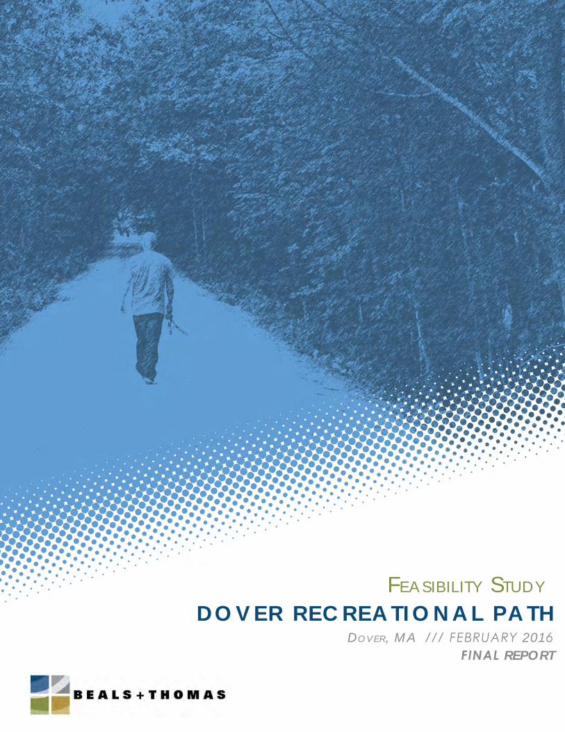
Report prepared by Beals and Thomas, Inc. for the Town of Dover, 2016 Cover Image: Holliston Rail Trail, Holliston, MA
Fig.1 Dedham Street CrossingFig.2 Springdale Avenue CrossingFig.3 Haven Street CrossingFig.4 Hunt Drive Crossing
CONTENTS
Executive Summary
List of Tables and Figures
Citations
Report Sections
Appendices
FEASIBILITY STUDY: DOVER RECREATIONAL PATH
A. INTRODUCTION & DATA GATHERING
B. PARKING AND ACCESS
C. AT-GRADE CROSSINGS
D. WETLANDS
E. DRAINAGE CONDITIONS
F. SITE ANALYSIS
G. LEASE CONSIDERATIONS
H. ENVIRONMENTAL CONSIDERATIONS
I. COST ESTIMATE
I. SITE ANALYSIS & CONCEPT PLANS
II. AT-GRADE CROSSING PLANS
III. DRTC PARKING ESTIMATES
IV. MBTA LEASE AGREEMENT
V. SOIL SAMPLING RECOMMENDATION
VI. COST ESTIMATE TABLE
VII. MAINTENANCE ACCOUNT BREAKDOWN
VIII. KNOLLWOOD DRIVE WELL ADDENDUM
08
10
12
15
19
24
28
30
34
40
54
59
60
82
83
84
85
04
39
07
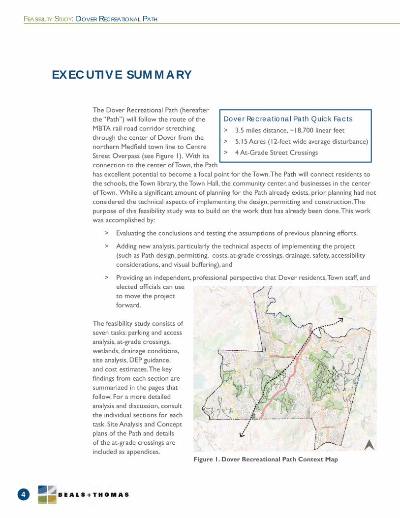
The Dover Recreational Path (hereafter the “Path”) will follow the route of the MBTA rail road corridor stretching through the center of Dover from the northern Medfi eld town line to Centre Street Overpass (see Figure 1). With its connection to the center of Town, the Path has excellent potential to become a focal point for the Town. The Path will connect residents to the schools, the Town library, the Town Hall, the community center, and businesses in the center of Town. While a signifi cant amount of planning for the Path already exists, prior planning had not considered the technical aspects of implementing the design, permitting and construction. The purpose of this feasibility study was to build on the work that has already been done. This work was accomplished by:
> Evaluating the conclusions and testing the assumptions of previous planning efforts,
> Adding new analysis, particularly the technical aspects of implementing the project (such as Path design, permitting, costs, at-grade crossings, drainage, safety, accessibility considerations, and visual buffering), and
> Providing an independent, professional perspective that Dover residents, Town staff, and elected offi cials can use to move the project forward.
The feasibility study consists of seven tasks: parking and access analysis, at-grade crossings, wetlands, drainage conditions, site analysis, DEP guidance, and cost estimates. The key fi ndings from each section are summarized in the pages that follow. For a more detailed analysis and discussion, consult the individual sections for each task. Site Analysis and Concept plans of the Path and details of the at-grade crossings are included as appendices.
FEASIBILITY STUDY: DOVER RECREATIONAL PATH
4
EXECUTIVE SUMMARY
> 3.5 miles distance, ~18,700 linear feet
> 5.15 Acres (12-feet wide average disturbance)
> 4 At-Grade Street Crossings
Dover Recreational Path Quick Facts
Figure 1. Dover Recreational Path Context Map

EXECUTIVE SUMMARY
FEASIBILITY STUDY: DOVER RECREATIONAL PATH
5
Beals and Thomas gathered data to identify the potential opportunities and constraints of developing the Path. We researched and reviewed existing plans from MassGIS, Town maps, railroad valuation maps, and prior studies; evaluated existing ownership, wetlands and permitting issues, potential abutter concerns and compliance with the Americans with Disabilities Act requirements at trail access points; reviewed Town regulations to identify potential considerations that may affect the design of the project; and prepared a base map of the study area for planning purposes.
Beals and Thomas reviewed the prior parking study. We agreed with the assessment that parking at the stated locations is adequate for the needs of the anticipated users of the Path. We recommend providing accessible parking at areas nearest to the Path and to include access paths from a number of these locations. We recommend an incremental approach to parking. Since the path will initially be promoted as a local path, parking needs will likely be minimal. If in the future parking does become an issue, other approaches, as noted, should be considered.
Beals and Thomas reviewed the at-grade street crossings of the Path. The Path crosses four roads at-grade. From south to north these are Hunt Drive, Springdale Avenue, Dedham Street, and Haven Street. We recommend that the Path crossings at Hunt Drive and Haven Street should include advanced warning signage and typical road signs. Due to the higher traffi c volumes on these streets and the uses and activities adjacent to the Path, we recommend that the Path crossings at Springdale Avenue and Dedham Street should include additional Rectangular Rapid Flashing Beacons (RRFB) to alert drivers to Path users at the crosswalks.
In addition to a site analysis by a professional wetland scientist, Beals and Thomas researched available information from MassGIS, FEMA fl ood maps, the Natural Heritage and Endangered Species Program, and local by-laws to determine potential resource areas and to consider design and permitting implications. Wetland and stream locations were generally consistent with MassGIS, although in certain areas wetlands were more extensive and closer to the rail bed. An approximately 1,300-foot-long section of the rail bed north of Hunt Drive is fl anked by railroad drainage ditches that now function as streams. With Conservation Commission concurrence, it may be appropriate to permit the majority, if not the entirety, of the Path through a Determination of Applicability process.
Section A: Introduction & Data Gathering
Section B: Parking & Access
Section C: At-Grade Crossings
Section D: Wetlands
Section E: Drainage ConditionsBeals and Thomas evaluated existing drainage conditions along the corridor, including existing culverts, and identifi ed areas with existing or potential drainage concerns. Culvert conditions
FEASIBILITY STUDY: DOVER RECREATIONAL PATH
6
SECTION A
were evaluated in the fi eld. Overall, the culverts were found to be in good condition; we recommend cleaning out those culverts requiring maintenance to prevent future fl ooding of the Path. Railroad drainage ditches have become intermittent streams over time and are now considered state and local jurisdictional resources. This will require narrowing the Path width, limiting vegetative removal to pruning and limbing the existing rail bed width, and incorporating a clear and appropriate construction sequence.
Beals and Thomas reviewed conditions along the corridor and evaluated adjacent uses to identify areas of potential concerns related to abutter impacts and mitigation, uses, access issues, steep slopes, and existing buffers. During site visits, areas where the Path is directly visible from adjacent residential properties were identifi ed. To address privacy and security concerns of abutters, we recommend these areas be planted to visually screen Path users from these residences. We recommend a minimum of 10 feet for paths with two-way travel. In certain instances, a reduced width of as much as 6 feet (for short distances) may be required. Where possible, a minimum 2-foot wide graded shoulder should be maintained adjacent to both sides of the Path. Where a slope of 2H:1V or greater exists within 5 feet of the edge of the Path and the height of the vertical drop is greater than 10 feet, we recommend installing a physical barrier or plantings near the top of the slope.
Beals and Thomas reviewed the requirements of the Massachusetts Bay Transportation Authority’s (MBTA) lease agreement to identify key issues affecting the acquisition, design, and maintenance of the corridor. The MBTA does not have written plan requirements, but plan reviews are expected to take 2 months. Although it is unlikely that the MBTA would require the Town to restore the corridor to the existing grade, we have estimated this cost. There are no specifi c submission requirements for as-built plans, but the MBTA generally expects a standard as-built plan along with the request for Notice of Project Completion.
Beals and Thomas researched available online databases from the MassDEP to determine potential sources of contamination within the study area and abutting properties. The purpose was to determine if there are obvious or known sources of contamination within the study area. Based on the fi ndings of our research, documented sources of contamination along the corridor, generally located in the downtown area, have been addressed. A review of the Valuation Maps showed there are no former battery vaults located along the proposed Path. The Valuation Maps depict two switches near Springdale Avenue, the former station, and an additional building. We recommended soil sampling protocols which include collecting regularly-spaced composite samples along the length of the rail trail corridor, as well as additional samples collected adjacent to former buildings and switches. Recommended sampling parameters include arsenic, lead, and
Section F: Site Analysis
Section G: Lease Considerations
Section H: Environmental Considerations
EXECUTIVE SUMMARY
Through the concept planning stages, Beals and Thomas researched and estimated relative “order-of-magnitude” costs for three alternatives: low-cost, a recommended option, and high-cost. The assumptions of each alternative are documented to justify estimated costs. Permitting costs and costs common to each of the alternatives are also discussed. The estimate ranges from $941,000 for the low-cost option to $1,373,400 for the high-cost option. The recommended alternative cost estimate is $1,074,600. The cost estimate also considered unlikely scenario and paved surface cost alternatives.
polycyclic aromatic hydrocarbons. This option entails a higher cost and provides the Town with a higher level of confi dence.
Section I: Cost Estimate
FEASIBILITY STUDY: DOVER RECREATIONAL PATH
7
Fig. 1 Dover Recreational Path Context MapFig. 2 Springdale Avenue and Dedham At-Grade CrossingsFig. 3 Hunt Drive Sight Distance Looking WesterlyFig. 4 Haven Street Sight Distance Looking WesterlyFig. 5 Dedham Street Sight Distance Looking WesterlyFig. 6 Springdale Avenue Sight Distance Looking WesterlyFig. 7/8 Drainage ditches now functioning as streamsFig. 9 Culvert 956 - 18” pipe requires cleaningFig. 10 Culvert 785 - 2.5’x2.5’ stone box in good conditionFig. 11 Existing “Valley” Condition Cross-SectionFig. 12 Proposed “Valley” Condition Path Cross-SectionFig. 13 Existing “Ridge” Condition Corridor Cross-SectionFig. 14 Proposed “Ridge” Condition Path Cross-SectionFig. 15 Existing “Narrow” (Steam) Condition Corridor Cross-SectionFig. 16 Proposed “Narrow” (Steam) Condition Path Cross-SectionFig. 17/18 Typical conditions where a physical barrier is recommendedFig. 19/20 Numerous private yards and homes are visible from the corridorFig. 21/22 Rail bridge crossings will require decking and hand railsFig. 23/24 Areas along Path with opportunity for scenic overlooksFig. 25/26 Dumping of snow & yard waste in a few areas along the PathFig. 27 Some rails have been removed along one section of the PathFig. 28 Graffi ti in the Centre Street underpass Fig. 29 Charles River Crossing AreaFig. 30 Rail crossing timber support structure is in sound condition but should be retreatedFig. 29 MADEP BMP Decision Tree
Table. 1 At-Grade Crossing Stopping Sight Distances Table. 2 Culvert ConditionsTable. 3 Paved Surface Alternative Costs
Figures
Tables
EXECUTIVE SUMMARY
LIST OF FIGURES AND TABLES
041213131414152020212122222323242526262627272727
32
131937
SECTION A
FEASIBILITY STUDY: DOVER RECREATIONAL PATH
SECTION A
8
INTRODUCTION & DATA GATHERING
> While a signifi cant body of planning for the Path already exists, prior planning had not considered the technical aspects of implementing the project such as path design, at-grade crossings, drainage, safety, accessibility considerations, and visual buffering.
> The purpose of this feasibility study was to evaluate the conclusions and test the assumptions of previous planning efforts, add new analysis, and provide an independent, professional perspective.
Key Findings
Drawing on years of experience designing, planning, permitting, and implementing rail trail projects, Beals and Thomas, Inc. knows these amenities offer signifi cant benefi ts to a community. The Path, with its connection to the center of Town, has excellent potential to become a focal point for the Town. The Path will connect residents to the schools, the Town library, the Town Hall, the community center, and businesses in the center of Town. It also provides the opportunity to inform the public of Dover’s history. The history of the railroad could be interpreted with images of the Dover Center Depot or tales of the Boston Girl Scouts riding the rail line to the camps in the area to take in the “fresh air.” Other unique natural features or historical information could also be showcased along the corridor.
A multi-use path is much different from a hiking trail. People who wouldn’t normally consider hiking in the woods will walk or ride on a multi-use path. Holliston—a nearby Town that recently implemented a rail trail project—has seen parents and empty nesters purchase bicycles and take up a healthy activity that they would not have considered otherwise due to the danger of riding on busy streets; now they take advantage of safer recreational opportunities provided by the Rail Trail. The fl at, even surface, with no obstructions, is ideal for all ages and abilities. Establishing the Path has the potential to serve as a spine to connect Dover’s signifi cant existing trail network, allowing Path users to explore natural areas and hiking trails off of the main Path.
Key components to planning and implementing a rail trail project are building consensus that the project is benefi cial for the Town and gaining community support for the project. Examples of this community-building process can be found locally with the Upper Charles Rail Trail in Holliston, Hopkinton, and Milford. These communities have created partnerships with numerous groups that have fostered activities and support. This process has already begun in Dover with the formation of the Dover Rail Trail Committee and the subsequent meetings and data gathering by that group which led to their 2014 report: Recreational Path Feasibility Study.
The purpose of this feasibility study was to build on the work that has already been done by:
> Evaluating the conclusions and testing the assumptions of previous planning efforts,
> Adding new analysis—particularly the technical aspects of implementing the project such
Introduction
The purpose of the data gathering phase was to identify the opportunities and constraints associated with constructing the Path. Data gathering included reviewing existing plans and relevant printed and electronic documentation, recording the existing conditions during numerous site visits, and researching relevant documentation related to right-of-way, legal issues, and permitting. Data gathering took place between May and July 2015. Spatial data was compiled into the base map (see Appendix I).
The documentation consulted includes, but is not limited to:
> Massachusetts Offi ce of Geographic Information (MassGIS) – used tax parcel boundary data, DEP wetland data, and LiDAR elevation data,
> Railroad Valuation Maps provided by the Town of Dover, with updated information to 1970, and review of the earlier, clearer original versions obtained online from the University of Connecticut Archives,
> Recreational Path Feasibility Study, prepared by the Dover Rail Trail Committee, Final Report, dated Spring 2014,
> MBTA Draft Lease, with a received date of April 8, 2013 from the Town of Dover,
> Wetlands Permitting and Construction Opinion memorandum from Paul McManus, EcoTec, Inc., dated July 24, 2012,
> Massachusetts Department of Environmental Protection’s Best Management Practices for Controlling the Exposure to Soil During the Development of Rail Trails, and
> Dover Wetlands Protection Bylaw, Chapter 181, dated 2005.
Data Gathering
SECTION A
FEASIBILITY STUDY: DOVER RECREATIONAL PATH
9
as path design, cost, at-grade crossings, drainage, safety, accessibility considerations, and visual buffering, and
> Providing an independent, professional perspective that Dover residents, Town staff, and elected offi cials can use to move the project forward.
FEASIBILITY STUDY: DOVER RECREATIONAL PATH
10
PARKING AND ACCESS ANALYSIS
SECTION B
> We generally agree with the assessment that parking areas at the various locations are viable for the intended localized use of the Path.
> We recommend providing accessible parking at various locations and to include access paths from a number of locations to direct the users to the Path.
> We recommend an incremental approach to parking. Since the path will be promoted as a local path, parking needs will likely be minimal. If in the future parking does become an issue, other approaches should be considered before constructing dedicated parking areas. This might include providing signage, public information, or websites to notify and direct users to park at other available parking areas.
Key Findings
The parking analysis included within the Dover Rail Trail Committee’s Study (the “DRTC study”) recommended that no additional parking capacity is required to support the Path’s usage. This was based on the anticipated low weekday demand and due to the fi nding that many local users are expected to arrive at trailheads by bicycling or walking.
The DRTC Study states that 155 parking spaces are available at various locations, with additional parking at Dedham Street, Caryl Park, and Chickering Fields. Observations of other rail trails indicate that the availability of suffi cient parking can become a signifi cant issue when the Path is considered a regional attraction. Another key consideration is the features that are available along the corridor, including scenic areas, restaurants, museums, parks, or other mutually-benefi cial activities. Based on the understanding that the Path is not intended to connect with the Path in Needham, the relatively short length of the Path is not anticipated to constitute a regional attraction. The parking would therefore mainly be used by residents of Dover who live in the immediate area of the Path or by those who join walking groups or attend promoted events.
We contacted representatives from the various parking locations identifi ed in Appendix III of the DRTC Study to confi rm the number and availability of spaces for Path users.
> Mr. Jack Savage, Commander of the Dover Legion, stated on June 1, 2015, that the potential exists for providing a maximum of 15 parking spaces with use-conditions and that the fi nal decision or conditions of use would require committee vote. Mr. Savage discussed potential timing considerations, such as when the Legion is open and when parking is likely to be made available to Path users.
> Ms. Cheryl Abdullah, Director of the Dover Town Library, on June 5, 2015, stated that the parking lot at the Library is considered a municipal lot and is available for public parking. However, the Library currently holds very popular events that already exceed the available parking. Path users and Library attendees vying for parking could be
DRTC Study
FEASIBILITY STUDY: DOVER RECREATIONAL PATH
11
problematic during popular Library events. She mentioned that there are mutual benefi ts between the Library and the Path because the Library is currently the “Heart of the Community” bringing people to the downtown area. She spoke of an outdoor area that could attract Path users to picnic or to attend events. One recommendation is to provide signage to direct Path users to other parking areas at peak times.
Potential parking areas are identifi ed in the plans included in Appendix I.
SECTION B
To comply with Federal and State accessibility laws, we recommend providing a minimum of six accessible parking spaces at available locations along the Path. Potential locations include the Dover Public Works Garage, the Dover Library, and on-street parking areas downtown. Costs were estimated for signage, pavement striping, and accessible paths at the recommended locations.
Appendix III includes the Dover Rail Trail Committee’s summary of the number of parking spaces available at various identifi ed location close to the path.
Accessible Parking
> The Path crosses fi ve roads. From south to north these are Hunt Drive, Springdale Avenue, Dedham Street, Haven Street, and Centre Street.
> We recommend that the Path crossings at Hunt Drive and Haven Street should include advanced warning signage and typical road markings with signage.
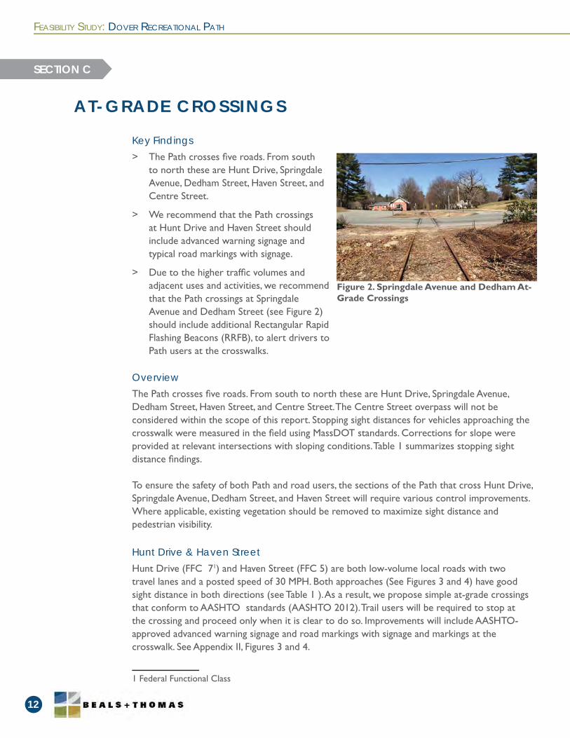
> Due to the higher traffi c volumes and adjacent uses and activities, we recommend that the Path crossings at Springdale Avenue and Dedham Street (see Figure 2) should include additional Rectangular Rapid Flashing Beacons (RRFB), to alert drivers to Path users at the crosswalks.
Key Findings
FEASIBILITY STUDY: DOVER RECREATIONAL PATH
12
AT-GRADE CROSSINGS
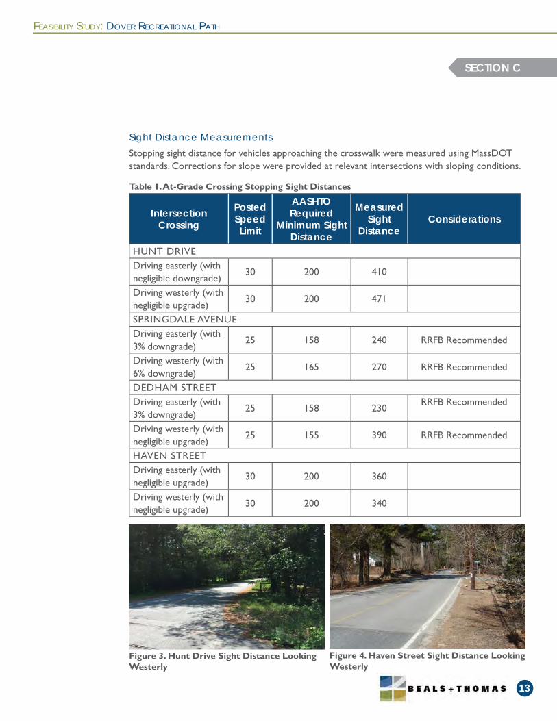
Hunt Drive (FFC 71) and Haven Street (FFC 5) are both low-volume local roads with two travel lanes and a posted speed of 30 MPH. Both approaches (See Figures 3 and 4) have good sight distance in both directions (see Table 1 ). As a result, we propose simple at-grade crossings that conform to AASHTO standards (AASHTO 2012). Trail users will be required to stop at the crossing and proceed only when it is clear to do so. Improvements will include AASHTO-approved advanced warning signage and road markings with signage and markings at the crosswalk. See Appendix II, Figures 3 and 4.
1 Federal Functional Class
The Path crosses fi ve roads. From south to north these are Hunt Drive, Springdale Avenue, Dedham Street, Haven Street, and Centre Street. The Centre Street overpass will not be considered within the scope of this report. Stopping sight distances for vehicles approaching the crosswalk were measured in the fi eld using MassDOT standards. Corrections for slope were provided at relevant intersections with sloping conditions. Table 1 summarizes stopping sight distance fi ndings.
To ensure the safety of both Path and road users, the sections of the Path that cross Hunt Drive, Springdale Avenue, Dedham Street, and Haven Street will require various control improvements. Where applicable, existing vegetation should be removed to maximize sight distance and pedestrian visibility.
Hunt Drive & Haven Street
Overview
SECTION C
Figure 2. Springdale Avenue and Dedham At-Grade Crossings
FEASIBILITY STUDY: DOVER RECREATIONAL PATH
13
SECTION C
IntersectionCrossing
Posted SpeedLimit
AASHTO Required
Minimum Sight Distance
Measured Sight
DistanceConsiderations
HUNT DRIVEDriving easterly (with negligible downgrade)
30 200 410
Driving westerly (with negligible upgrade)
30 200 471
SPRINGDALE AVENUEDriving easterly (with 3% downgrade)
25 158 240 RRFB Recommended
Driving westerly (with 6% downgrade)
25 165 270 RRFB Recommended
DEDHAM STREETDriving easterly (with 3% downgrade)
25 158 230RRFB Recommended
Driving westerly (with negligible upgrade)
25 155 390 RRFB Recommended
HAVEN STREETDriving easterly (with negligible upgrade)
30 200 360
Driving westerly (with negligible upgrade)
30 200 340
Figure 4. Haven Street Sight Distance Looking Westerly
Figure 3. Hunt Drive Sight Distance Looking Westerly
Table 1. At-Grade Crossing Stopping Sight Distances
Stopping sight distance for vehicles approaching the crosswalk were measured using MassDOT standards. Corrections for slope were provided at relevant intersections with sloping conditions.
Sight Distance Measurements
Due to their proximity, Springdale Avenue and Dedham Street will be considered together. Springdale Avenue is considered a minor arterial road (FFC 4) and will need more advanced roadway signaling and control to ensure the safety of both Path and road users.
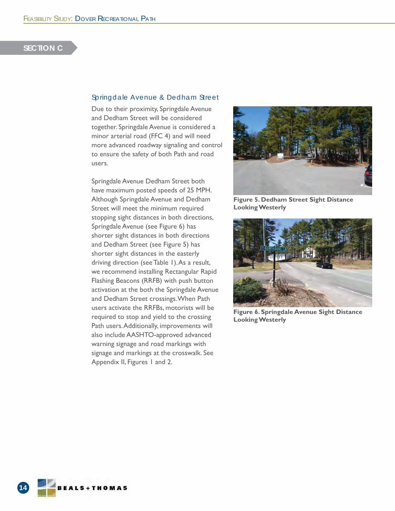
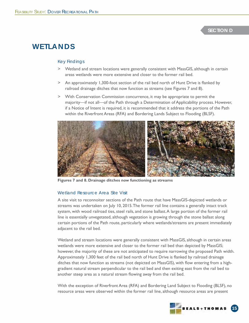
Springdale Avenue Dedham Street both have maximum posted speeds of 25 MPH. Although Springdale Avenue and Dedham Street will meet the minimum required stopping sight distances in both directions, Springdale Avenue (see Figure 6) has shorter sight distances in both directions and Dedham Street (see Figure 5) has shorter sight distances in the easterly driving direction (see Table 1). As a result, we recommend installing Rectangular Rapid Flashing Beacons (RRFB) with push button activation at the both the Springdale Avenue and Dedham Street crossings. When Path users activate the RRFBs, motorists will be required to stop and yield to the crossing Path users. Additionally, improvements will also include AASHTO-approved advanced warning signage and road markings with signage and markings at the crosswalk. See Appendix II, Figures 1 and 2.
Springdale Avenue & Dedham Street
FEASIBILITY STUDY: DOVER RECREATIONAL PATH
14
SECTION C
Figure 5. Dedham Street Sight Distance Looking Westerly
Figure 6. Springdale Avenue Sight Distance Looking Westerly
> Wetland and stream locations were generally consistent with MassGIS, although in certain areas wetlands were more extensive and closer to the former rail bed.
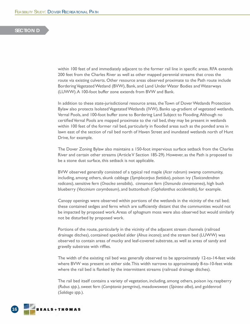
> An approximately 1,300-foot section of the rail bed north of Hunt Drive is fl anked by railroad drainage ditches that now function as streams (see Figures 7 and 8).
> With Conservation Commission concurrence, it may be appropriate to permit the majority—if not all—of the Path through a Determination of Applicability process. However, if a Notice of Intent is required, it is recommended that it address the portions of the Path within the Riverfront Areas (RFA) and Bordering Lands Subject to Flooding (BLSF).
Key Findings
FEASIBILITY STUDY: DOVER RECREATIONAL PATH
15
WETLANDS
SECTION D
Figures 7 and 8. Drainage ditches now functioning as streams
A site visit to reconnoiter sections of the Path route that have MassGIS-depicted wetlands or streams was undertaken on July 10, 2015. The former rail line contains a generally intact track system, with wood railroad ties, steel rails, and stone ballast. A large portion of the former rail line is essentially unvegetated, although vegetation is growing through the stone ballast along certain portions of the Path route, particularly where wetlands/streams are present immediately adjacent to the rail bed.
Wetland and stream locations were generally consistent with MassGIS, although in certain areas wetlands were more extensive and closer to the former rail bed than depicted by MassGIS; however, the majority of these are not anticipated to require narrowing the proposed Path width. Approximately 1,300 feet of the rail bed north of Hunt Drive is fl anked by railroad drainage ditches that now function as streams (not depicted on MassGIS), with fl ow entering from a high-gradient natural stream perpendicular to the rail bed and then exiting east from the rail bed to another steep area as a natural stream fl owing away from the rail bed.
With the exception of Riverfront Area (RFA) and Bordering Land Subject to Flooding (BLSF), no resource areas were observed within the former rail line, although resource areas are present
Wetland Resource Area Site Visit
within 100 feet of and immediately adjacent to the former rail line in specifi c areas. RFA extends 200 feet from the Charles River as well as other mapped perennial streams that cross the route via existing culverts. Other resource areas observed proximate to the Path route include Bordering Vegetated Wetland (BVW), Bank, and Land Under Water Bodies and Waterways (LUWW). A 100-foot buffer zone extends from BVW and Bank.
In addition to these state-jurisdictional resource areas, the Town of Dover Wetlands Protection Bylaw also protects Isolated Vegetated Wetlands (IVW), Banks up-gradient of vegetated wetlands, Vernal Pools, and 100-foot buffer zone to Bordering Land Subject to Flooding. Although no certifi ed Vernal Pools are mapped proximate to the rail bed, they may be present in wetlands within 100 feet of the former rail bed, particularly in fl ooded areas such as the ponded area in lawn east of the section of rail bed north of Haven Street and inundated wetlands north of Hunt Drive, for example.
The Dover Zoning Bylaw also maintains a 150-foot impervious surface setback from the Charles River and certain other streams (Article V Section 185-29). However, as the Path is proposed to be a stone dust surface, this setback is not applicable.
BVW observed generally consisted of a typical red maple (Acer rubrum) swamp community, including, among others, skunk cabbage (Symplocarpus foetidus), poison ivy (Toxicondendron radicans), sensitive fern (Onoclea sensibilis), cinnamon fern (Osmunda cinnamomea), high bush blueberry (Vaccinium corymbosum), and buttonbush (Cephalanthus occidentalis), for example.
Canopy openings were observed within portions of the wetlands in the vicinity of the rail bed; these contained sedges and ferns which are suffi ciently distant that the communities would not be impacted by proposed work. Areas of sphagnum moss were also observed but would similarly not be disturbed by proposed work.
Portions of the route, particularly in the vicinity of the adjacent stream channels (railroad drainage ditches), contained speckled alder (Alnus incana); and the stream bed (LUWW) was observed to contain areas of mucky and leaf-covered substrate, as well as areas of sandy and gravelly substrate with riffl es.
The width of the existing rail bed was generally observed to be approximately 12-to-14-feet wide where BVW was present on either side. This width narrows to approximately 8-to-10-feet wide where the rail bed is fl anked by the intermittent streams (railroad drainage ditches).
The rail bed itself contains a variety of vegetation, including, among others, poison ivy, raspberry (Rubus spp.), sweet fern (Comptonia peregrina), meadowsweet (Spiraea alba), and goldenrod (Solidago spp.).
FEASIBILITY STUDY: DOVER RECREATIONAL PATH
16
SECTION D
FEASIBILITY STUDY: DOVER RECREATIONAL PATH
17
Dry swales adjacent to the rail bed were observed to contain upland vegetation such as sassafras (Sassafras albidum) and exhibited non-hydric soils with no evidence of fl ow; whether these constitute intermittent streams will be evaluated in more detail when the resource area delineation is undertaken.
Invasive species observed within and adjacent to the portions of the former rail line reconnoitered include bittersweet (Celastrus orbiculata), common reed (Phragmites australis), and glossy buckthorn (Rhamnus frangula). An EcoTec, Inc. letter dated July 24, 2012 (the EcoTec Letter) that summarizes a reconnaissance of the entire route additionally notes tartarian honeysuckle (Lonicera tatarica), winged euonymus (Euonymus alatus), and Japanese barberry (Berberis thunbergii).
SECTION D
With Conservation Commission concurrence, it may be appropriate to permit the majority if not the entirety of the Path through a Determination of Applicability process. However, if a Notice of Intent is required it is recommended that it address the portions of the Path within RFA and BLSF, and possibly the sections that lie immediately adjacent to streams and other areas where buffer zone setback exceptions from the Rules and Regulations for the Dover Wetlands Protection Bylaw are required (see further discussion below). Additionally, an evaluation of whether a wildlife habitat evaluation for work in RFA and BLSF is required should be undertaken subsequent to delineation of these resource areas and evaluation of the total area of impact.
Specifi cally, given the location and disturbed nature of the proposed route, it is anticipated to be feasible to construct the Path without direct impacts to BVW, Bank or LUWW resource areas that are present adjacent to the route. Additionally, at certain “pinch” points where the former rail bed is fl anked by streams (railroad drainage ditches), it is anticipated to be feasible to construct the Path such that work within the buffer zone will not indirectly adversely affect adjacent resource areas. Achieving this will require:
> Narrowing the Path width,
> Limiting vegetative removal and pruning/limbing to the existing rail bed width, such that potential changes in shading regime are avoided, and
> Incorporation of a clear and appropriate construction sequence.
Furthermore, in areas where the proposed Path lies within RFA, the streams are already crossed by existing culverts, the proposed work may qualify as redevelopment of previously developed RFA if measures to improve existing conditions are included, and even if not undertaken as redevelopment, the proposed work is not anticipated to signifi cantly alter the character of the RFA.
Regulatory Considerations (Conservation Commission)
Similarly, work within BLSF will not signifi cantly change the existing elevations within that resource area, and with incorporation of the previously-listed measures for constrained areas the work will meet the applicable state and local performance standards for BLSF.
Additionally, even if Vernal Pools are present within 100 feet of the proposed route, the conversion of the former rail bed to a stone dust path will not impair their capacity to function, including allowing migration of animals to and from the pools. The Rules and Regulations for the Dover Wetlands Protection Bylaw presume that work within undeveloped and unimproved areas within 100 feet of a Vernal Pool will impair the pool’s capacity to function. Given the existing disturbed and previously developed nature of the rail bed and the anticipated insignifi cant change in character from the existing rail bed to the proposed path, it is anticipated that compliance with the Vernal Pool presumption and performance standards will be achieved.
Finally, although some of the work within the 100-foot buffer zone will occur in close proximity to resource areas, the work is not anticipated to adversely affect soil stabilization, wildlife habitat cover, shading, or other contributions of the buffer zone to these resource areas. The Rules and Regulations for the Dover Wetlands Protection Bylaw require that no more than 50 percent tree cover be removed for any one-hundred-foot long section of buffer zone, which is anticipated to be met. The Regulations also maintain disturbance and structure setbacks, the distance of which depends upon slope (30 feet for steep slopes and 25 feet for shallow slopes). Exceptions to the disturbance setback will be necessary. Note that the Regulations specify that exceptions to the structure setback may be granted, but the Regulations are silent with regard to disturbance setback exceptions.
It will be necessary to demonstrate compliance with state and local performance standards in the fi ling(s) with the Conservation Commission, and as previously noted, coordination with the Conservation Commission to confi rm the preferred permitting approach is recommended.
FEASIBILITY STUDY: DOVER RECREATIONAL PATH
18
SECTION D
FEASIBILITY STUDY: DOVER RECREATIONAL PATH
19
DRAINAGE CONDITIONS
SECTION E
> Culvert conditions were evaluated in the fi eld. Overall, culverts were found to be in good condition; we recommend cleaning out those culverts requiring maintenance to prevent future fl ooding of the Path.
> Railroad drainage ditches have become intermittent streams overtime and are now considered state and local jurisdictional resources. This will require narrowing the Path width, limiting vegetative removal and pruning/limbing to the existing rail bed width, and incorporating a clear and appropriate construction sequence.
Key Findings
During site visits culvert conditions were noted (see Figures 9 and 10) along with any identifi ed drainage concerns. Culvert conditions are noted below in Table 2:
Culvert Condition Inspections
Val Map Feature Number
Structure Condition Notes Action Needed
Handrail Needed
770+133.5'x4' Stone box
Good Clear None Yes
978 1'x1' Stone box Not found
974 6'x5' Stone box Good ClearRetreat Timber, install decking
Yes
968 2'x2' Stone box PoorFilled with sediment, 11" clear
Clear sedimentYes
96310'x5.5' rail top crossing
FairSome surface rot at base of posts, but structurally sound
Retreat Timber, install decking Yes
95618" Cast Iron pipe
Poor
Filled with sediment, 11" clear; stones on west side have collapsed
Clear sediment; reset stones
Yes
948 2'x2' Stone box PoorFilled with sediment, 10" clear
Clear sediment Yes
921 3'x3' Stone box PoorFilled with sediment and debris, 5" clear
Clear sediment and debris
No
835 3'x3' Stone box Good Clear None No
Table 2. Culvert Conditions
FEASIBILITY STUDY: DOVER RECREATIONAL PATH
20
SECTION E
Val Map Feature Number
Structure Condition Notes Action Needed
Handrail Needed
7852.5'x2.5' Stone box
Good Clear None No
7703.5'x3.5' Stone box
Good Clear None No
7452.5'x3' Stone box
Good 2'-3" clear None No
Figure 10. Culvert 785 - 2.5’x2.5’ stone box in good condition
Figure 9. Culvert 956 - 18” pipe requires cleaning
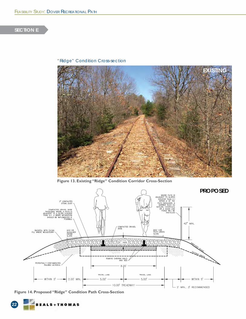
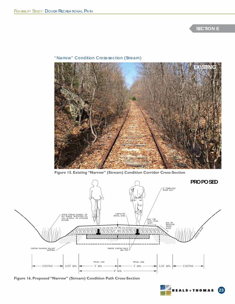
There are three typical Path cross-sections that respond to the rail bed’s existing condition: a “valley” condition where the terrain rises up from the edges of the rail bed (see Figure 11), a “ridge” condition where the terrain drops off from the rail bed (see Figure 13), and a “narrow”condition (see Figure 15). The “narrow” condition contain a section of the Path where intermittent streams along the rail bed constrain the width of the path and cannot be fi lled because they are considered jurisdictional resources. Each of these Path cross-section conditions is represented below, showing the dimensions of the travel lanes, shoulders, and other design elements (see Figures 12, 14, 16).
In the “narrow” condition where the former rail bed is fl anked by intermittent streams (railroad drainage ditches), it is anticipated to be feasible to construct the Path so that work within the buffer zone will not indirectly adversely affect adjacent resource areas. To achieve this, the Path width will have to narrow to as little as 6 feet. Vegetation removal in this area will be limited to pruning and limbing of the existing rail bed width to avoid potential changes in shading. See Section D for in-depth discussion of wetland issues.
Path Cross-Sections
Figure 11. Existing “Valley” Condition Corridor Cross-Section
Figure 12. Proposed “Valley” Condition Path Cross-Section
FEASIBILITY STUDY: DOVER RECREATIONAL PATH
21
“Valley” Condition Cross-section
SECTION E
EXISTING
PROPOSED
FEASIBILITY STUDY: DOVER RECREATIONAL PATH
22
SECTION E
Figure 13. Existing “Ridge” Condition Corridor Cross-Section
“Ridge” Condition Cross-section
PROPOSED
EXISTING
Figure 14. Proposed “Ridge” Condition Path Cross-Section
FEASIBILITY STUDY: DOVER RECREATIONAL PATH
23
SECTION E
Figure 15. Existing “Narrow” (Stream) Condition Corridor Cross-Section
Figure 16. Proposed “Narrow” (Stream) Condition Path Cross-Section
“Narrow” Condition Cross-section (Stream)
PROPOSED
EXISTING
FEASIBILITY STUDY: DOVER RECREATIONAL PATH
24
SECTION F
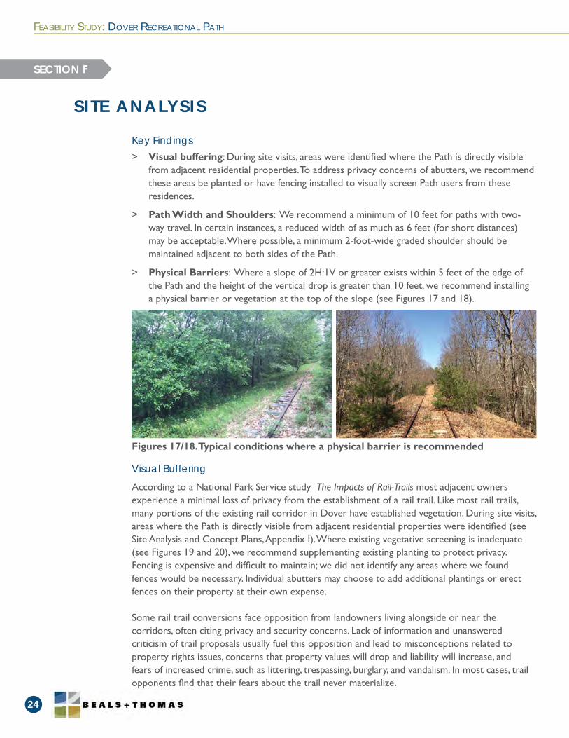
Figures 17/18. Typical conditions where a physical barrier is recommended
> Visual buffering: During site visits, areas were identifi ed where the Path is directly visiblefrom adjacent residential properties. To address privacy concerns of abutters, we recommendthese areas be planted or have fencing installed to visually screen Path users from theseresidences.
> Path Width and Shoulders: We recommend a minimum of 10 feet for paths with two-way travel. In certain instances, a reduced width of as much as 6 feet (for short distances)may be acceptable. Where possible, a minimum 2-foot-wide graded shoulder should bemaintained adjacent to both sides of the Path.
> Physical Barriers: Where a slope of 2H:1V or greater exists within 5 feet of the edge ofthe Path and the height of the vertical drop is greater than 10 feet, we recommend installinga physical barrier or vegetation at the top of the slope (see Figures 17 and 18).
Key Findings
SITE ANALYSIS
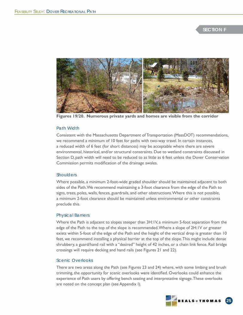
According to a National Park Service study The Impacts of Rail-Trails most adjacent owners experience a minimal loss of privacy from the establishment of a rail trail. Like most rail trails, many portions of the existing rail corridor in Dover have established vegetation. During site visits, areas where the Path is directly visible from adjacent residential properties were identifi ed (see Site Analysis and Concept Plans, Appendix I). Where existing vegetative screening is inadequate (see Figures 19 and 20), we recommend supplementing existing planting to protect privacy. Fencing is expensive and diffi cult to maintain; we did not identify any areas where we found fences would be necessary. Individual abutters may choose to add additional plantings or erect fences on their property at their own expense.
Some rail trail conversions face opposition from landowners living alongside or near the corridors, often citing privacy and security concerns. Lack of information and unanswered criticism of trail proposals usually fuel this opposition and lead to misconceptions related to property rights issues, concerns that property values will drop and liability will increase, and fears of increased crime, such as littering, trespassing, burglary, and vandalism. In most cases, trail opponents fi nd that their fears about the trail never materialize.
Visual Buffering
FEASIBILITY STUDY: DOVER RECREATIONAL PATH
25
SECTION F
Consistent with the Massachusetts Department of Transportation (MassDOT) recommendations, we recommend a minimum of 10 feet for paths with two-way travel. In certain instances, a reduced width of 6 feet (for short distances) may be acceptable where there are severe environmental, historical, and/or structural constraints. Due to wetland constraints discussed in Section D, path width will need to be reduced to as little as 6 feet unless the Dover Conservation Commission permits modifi cation of the drainage swales.
Where possible, a minimum 2-foot-wide graded shoulder should be maintained adjacent to both sides of the Path. We recommend maintaining a 3-foot clearance from the edge of the Path to signs, trees, poles, walls, fences, guardrails, and other obstructions. Where this is not possible, a minimum 2-foot clearance should be maintained unless environmental or other constraints preclude this.
Where the Path is adjacent to slopes steeper than 3H:1V, a minimum 5-foot separation from the edge of the Path to the top of the slope is recommended. Where a slope of 2H:1V or greater exists within 5-foot of the edge of the Path and the height of the vertical drop is greater than 10 feet, we recommend installing a physical barrier at the top of the slope. This might include dense shrubbery, a guard/hand rail with a “desired” height of 42 inches, or a chain link fence. Rail bridge crossings will require decking and hand rails (see Figures 21 and 22).
There are two areas along the Path (see Figures 23 and 24) where, with some limbing and brush trimming, the opportunity for scenic overlooks were identifi ed. Overlooks could enhance the experience of Path users by offering bench seating and interpretative signage. These overlooks are noted on the concept plan (see Appendix I).
Path Width
Shoulders
Physical Barriers
Scenic Overlooks
Figures 19/20. Numerous private yards and homes are visible from the corridor

FEASIBILITY STUDY: DOVER RECREATIONAL PATH
26
SECTION F
Figures 21/22. Rail bridge crossings will require decking and hand rails
Figures 23/24. Areas along Path with opportunity for scenic overlooks
Figures 25/26. Dumping of snow and yard waste in a few areas along the Path
FEASIBILITY STUDY: DOVER RECREATIONAL PATH
27
SECTION F
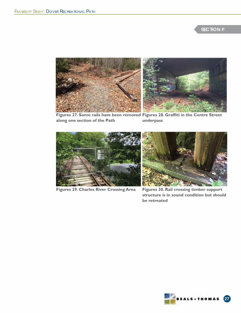
Figures 27. Some rails have been removed along one section of the Path
Figures 29. Charles River Crossing Area
Figures 28. Graffi ti in the Centre Street underpass
Figures 30. Rail crossing timber support structure is in sound condition but should be retreated
The Massachusetts Bay Transportation Authority (the “MBTA”) has provided a draft lease agreement to the Town of Dover, entitled Alternative Transportation Corridor Lease Agreement between MBTA and the Town of Dover, dated 2013 (Appendix IV) . This Agreement includes terms that we understand are not open to modifi cation. The Dover Board of Selectmen obtained a Summary of Lease Terms and Environmental Issues memorandum, prepared by M. Anderson & Krieger LLP, dated September 12, 2012, relative to this draft lease agreement. The memorandum identifi es important lease terms and environmental considerations.
As discussed in the section “Experience of Other Communities” in the memorandum, special conditions were included in leases between MBTA and the Cities of Malden and Everett that had known pre-existing contaminated sites. Beals and Thomas performed research, as noted in Task 8, to determine if any pre-existing contaminated sites are known along or adjacent to the corridor.
We contacted Ms. Pat Fitzgibbon, Massachusetts Realty Group on June 9, 2015 to discuss the lease considerations. The following discusses the issues clarifi ed based on that discussion.
1. The lease states that “a failure to undertake efforts to secure funds may negate themunicipal liability exemption.” A question was raised based on the potential for Doverto phase or segment the project over a longer duration. Ms. Fitzgibbon stated that theMBTA realizes that the projects typically take time to be implemented, and specifi cally, based on the time to secure funds, that they may be phased.
2. There is a provision in the lease, Condition 12, that may require “Dover” to restorethe Premises to the grade existing at the commencement of this lease. This essentiallymeans that the MBTA could require the removal of all imported gravel and stone dustsurface material if the lease is terminated. The clause is in the lease, but it is not likelyto be enforced by the MBTA, and Ms. Fitzgibbon stated that she is not aware of anytimes that this has occurred. Given that this is not likely to occur, we have neverthelessestimated costs for removal of material, in today’s prices, in the unlikely event that it maybe required.
Key Findings
Background
FEASIBILITY STUDY: DOVER RECREATIONAL PATH
28
LEASE CONSIDERATIONS
SECTION G
> Funding for the Path may be phased without negating the municipal liability exemption.
> Although it is unlikely that the MBTA would require the Town to restore the Premises to thegrade existing at the commencement of this lease, we have estimated this cost.
> MBTA does not have specifi c plan or submission requirements, but plan reviews are expectedto take 2 months.
> There are no specifi c submission requirements for as-built plans, but the MBTA generallyexpects a standard as-built plan along with the request for Notice of Project Completion.
FEASIBILITY STUDY: DOVER RECREATIONAL PATH
29
3. Condition 3 of the Lease agreement states that the “Corridor is to be used for purposesof installation, operation, maintenance and use of a rail trail…” The question was askedwhether or not sections of the corridor may remain unused (undeveloped for purposesof a rail trail). Ms. Fitzgibbon stated that this would need to be answered by legal counsel.
4. The MBTA is not aware of any specifi c plan or submission requirements. Ms. Fitzgibbonstated that the plans once submitted to MBTA for review will be distributed to variousoffi ces including Safety, Design and Construction, and the Railroad group to approveor disapprove the plans. Generally, these groups expect fully surveyed plans, accuratelymapped wetlands, and adequate design and safety improvements. Even though theprocess takes a minimum of one month, two months should be anticipated for MBTAreview.
5. Ms. Fitzgibbon is not aware of specifi c submission requirements for as-built plans, but theMBTA generally expects a standard as-built plan along with the request for Notice ofProject Completion, rather than a contractor’s record drawing.
SECTION G
> Based on the fi ndings of our research, documented sources of contamination along thecorridor, generally located in the downtown area, have been addressed.
> Based on a review of the Valuation Maps, there are no battery vaults located along theproposed Path. The Valuation Maps depict two switches near Springdale Street, the formerstation, and an additional building.
> Recommended protocols for soil sampling include collection of regularly-spaced compositesamples along the length of the rail trail corridor, as well as additional samples collectedadjacent to former buildings and switches. Recommended sampling parameters includearsenic, lead, and polycyclic aromatic hydrocarbons. This option entails a higher cost.
> Due to the corridor’s location in historically residential, rural and signifi cant areas ofundeveloped land, a reduced sampling program could be considered.
> We recommended path design and development follow MADEP’s Best Management Practicesfor Controlling Exposure to Soil during the Development of Rail Trails.
Key Findings
FEASIBILITY STUDY: DOVER RECREATIONAL PATH
30
ENVIRONMENTAL CONSIDERATIONS
SECTION H
The purpose of this section is to identify potential contamination issues within or in close proximity to the project corridor.
Contamination along a former rail corridor is typically the result of either residual contamination from railroad operations or contamination associated with adjacent uses along the corridor.
The most common contamination found along a rail corridor is residual contamination from railroad operations. According to the Rails-to-Trail Conservancy’s study on “Understanding Environmental Contaminants” (October 2004), the most commonly reported contaminants along rail corridors include arsenic, which was used as an herbicide to control weeds, metals and constituents of oil or fuel (petroleum products), which likely dripped from the rail cars as they passed over the corridor. Coal ash is also considered residual contamination. In addition, any existing railroad ties along a corridor were likely treated with creosote and therefore need to be removed and transported in accordance with local, state, and federal hazardous waste disposal requirements.
There is also the possibility that use histories of adjacent properties may have resulted in contamination along the corridor. Such histories could include improper disposal actions along the rail corridor or a release of oil or hazardous material on an adjacent site.
On June 5, 2015, Beals and Thomas reviewed the Waste Site/Reportable Release Look Up and Release Lists for the Town of Dover. We reviewed fi les for four releases in the vicinity of the proposed Path. Please note that only the most recent MassDEP fi le with comprehensive site information was reviewed for each site where fi les were available.
Introduction
MADEP Research

FEASIBILITY STUDY: DOVER RECREATIONAL PATH
31
SECTION H
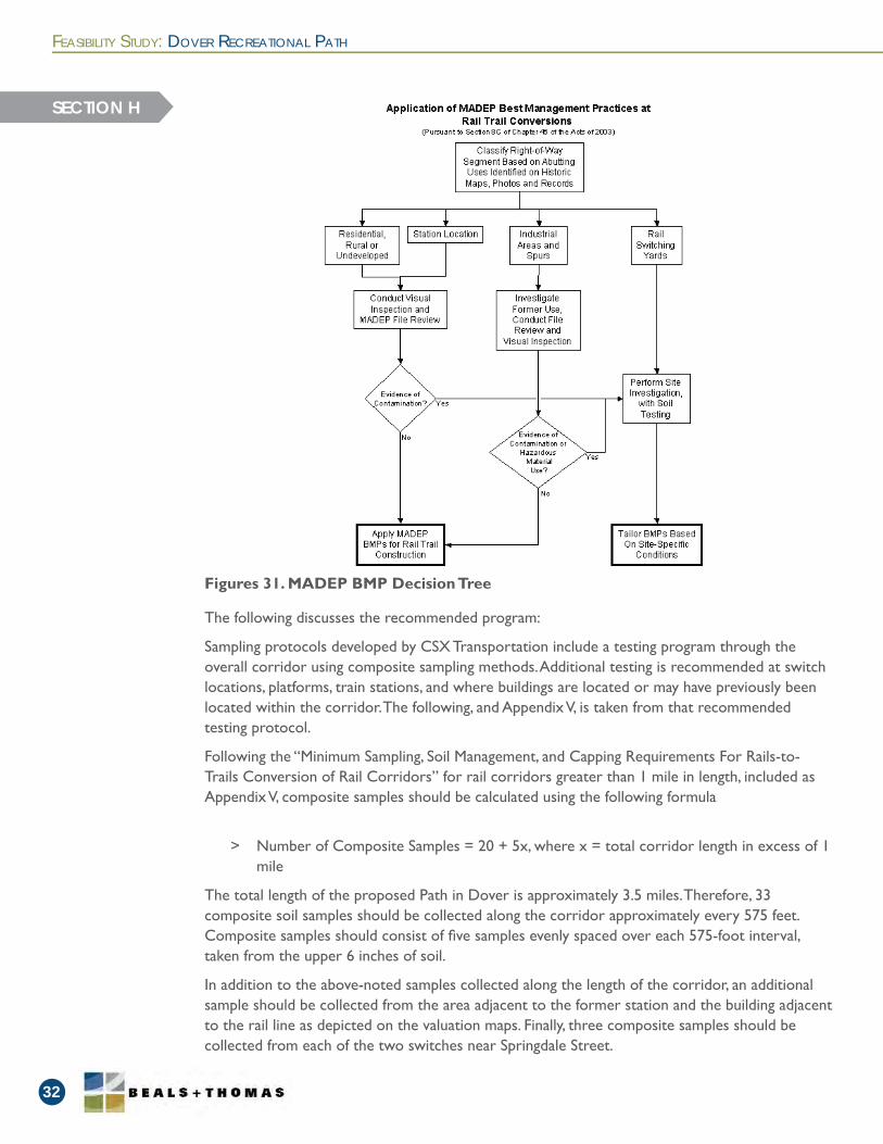
MADEP Best Management Practices at Rail Trail Conversions employ a decision tree (see Figure 31) for assessing when testing is reccommended. Visual inspection of the site did not identifyobvious signs of contamination. To better understand the potential for contaminants to existwithin the railbed, we recommend a limited testing program that samples the soils at variousintervals in the corridor and at former switch locations.
Recommended Testing
> Dover Highway Department, 2 Dedham Street, RTN 3-0003865: According totheResponse Action Outcome Statement dated August 1, 1997, methyl-tert butylether(MTBE) and ethylene dibromide (EDB) were detected in municipal wells onChurchStreet. The source of contamination was presumed to be from a Mobile Oilservicestation and the DPW. A Phase I report with the conclusion that the HighwayDepartmentGarage, located adjacent to the western boundary of the proposed Path, wasnot thesource of EDB was submitted to MassDEP in 1993. The site achieved closure inAugust1997 with a Class B1 Response Action Outcome, indicating that remedial actionswerenot conducted because a level of No Signifi cant Risk exists.
> Dover Garage, 4 Whiting Road, RTN 3-0010973: The only fi le available online fromtheMassDEP Bureau of Waste Site Cleanup for this site was a Release AmendmentFormdated February 26, 2009 which did not describe the release. According totheSite Information page for the site, a number of chemicals (1,1,2-trichloroethane; 1,1-dichloroethane; 1,2-dichloroethane; 2-butanone; 2-pentanone, 4-methyl-; benzene; benzene, dimethyl-, benzene, ethyl-; ethane, tetrachloro; ethane, trichloro-; toluene, andwaste oil) from an unknown source were detected in May 1994 approximately 200feetto the east of the proposed Path. An Immediate Response Action was conducted. Thesiteachieved closure in May 1995 with a Class A2 Response Action Outcome, indicatingthata permanent solution had been achieved and a level of No Signifi cant Risk existed, butcontamination had not been reduced to background.
> Off Haven Street, 9 Haven Terrace, RTN 3-0012906: According to the ResponseActionOutcome Statement Supporting Information, dated January 6, 1996, approximately200to 300 gallons of no. 2 fuel oil from a fuel supply line were released beneath theconcretefl oor in the basement of a residence located approximately 100 feet to the westof theproposed Path. Approximately 100 cubic yards of soil were removed, stockpiled, anddisposed of under an Immediate Response Action Plan. The site achieved closure inJanuary 1996 with a Class A2 Response Action Outcome.
> Intersection with Springdale Ave, 2 Whiting Road, RTN 3-0018654: The only fi leavailableonline from the MassDEP Bureau of Waste Site Cleanup for this site was aReleaseNotifi cation Form dated September 16, 1999 which only indicated that 14,600mg/kgof no. 2 fuel oil was released approximately 200 feet to the east of the proposedPathon July 30, 1999. According to the Site Information page for the site, the siteachievedclosure in January 2000 with a Class A2 Response Action Outcome.
According to MassGIS, there are no underground storage tanks, Solid Waste Land Disposal sites, or Bureau of Waste Prevention Major Facilities within the general vicinity of the proposed Path.
FEASIBILITY STUDY: DOVER RECREATIONAL PATH
32
SECTION H
The following discusses the recommended program:
Sampling protocols developed by CSX Transportation include a testing program through the overall corridor using composite sampling methods. Additional testing is recommended at switch locations, platforms, train stations, and where buildings are located or may have previously been located within the corridor. The following, and Appendix V, is taken from that recommended testing protocol.
Following the “Minimum Sampling, Soil Management, and Capping Requirements For Rails-to-Trails Conversion of Rail Corridors” for rail corridors greater than 1 mile in length, included as Appendix V, composite samples should be calculated using the following formula
> Number of Composite Samples = 20 + 5x, where x = total corridor length in excess of 1mile
The total length of the proposed Path in Dover is approximately 3.5 miles. Therefore, 33 composite soil samples should be collected along the corridor approximately every 575 feet. Composite samples should consist of fi ve samples evenly spaced over each 575-foot interval, taken from the upper 6 inches of soil.
In addition to the above-noted samples collected along the length of the corridor, an additional sample should be collected from the area adjacent to the former station and the building adjacent to the rail line as depicted on the valuation maps. Finally, three composite samples should be collected from each of the two switches near Springdale Street.
Figures 31. MADEP BMP Decision Tree

FEASIBILITY STUDY: DOVER RECREATIONAL PATH
33
SECTION H
The total estimated sampling quantity is thus 41 samples.
The following parameters are recommended for testing:> Arsenic,> Lead, and> Polycyclic Aromatic Hydrocarbons (PAH).
Coal AshA recent concern across the state has been the presence of coal ash along former railroad corridors. Coal ash is residual contamination from former railroad operations. This by-product is exempt from the Massachusetts Contingency Plan (MCP). The MCP (310 CMR 40.0000) is the set of regulations that governs the reporting, assessment and cleanup of oil and hazardous material spills in Massachusetts.
While, it is acceptable to both leave and re-use soil containing coal ash along a corridor, the DEP’s antidegradation policy restricts off-site reuse to a similar setting. Consequently, leftover materials may need to be transported to an approved landfi ll at additional costs to the Contractor, which ultimately increases the overall cost of the trail project to the Town. It is therefore important for the trail design to balance cut and fi ll volumes to minimize any transportation of material off-site. We recommend following a plan to minimize cut within the corridor and instead use the gravel and stone dust as fi ll over the existing grade to the maximum extent possible with no soil material to be removed from the site.
We recommended the proposed path design and development conforms to MADEP’s Best Management Practices for Controlling Exposure to Soil during the Development of Rail Trails. Our proposed design recommendations are based on BMPs.
These BMPs were developed by MADEP to eliminate or minimize potential exposures to residual oil or hazardous materials commonly found along railroad rights-of-way being converted to rail trails. MADEP notes that these BMPs, by themselves, are insuffi cient for use without more extensive site investigation in industrial areas with known or likely non-railroad sources, or in rail yards. As a result, the purpose of additional sampling using the CSX sampling method is:
1. To identify potential areas of contamination that exceed residual levels and require moreextensive environmental remediation before path development
2. Rule out areas with no contamination or residual contamination levels in order to tailorthe application of BMPs to site-specifi c conditions
It should be noted that the rail trail construction would not introduce any hazardous waste or contaminated materials to the project area. Design plans and specifi cations should contain spill prevention plans and protocols, EPA standards, and contain specifi c BMPs from the MADEP Best Management Practices for Controlling Exposure to Soil during the Development of Rail Trails.
Design Implications
> Through the concept planning stages, Beals and Thomas researched and estimated relative“order-of-magnitude” costs for three alternatives: low-cost, a recommended option, and high-cost. The assumptions of each alternative are documented to justify estimated costs.
> Permitting costs and costs common across each of the alternatives are also discussed.
> The estimate ranges from $941,000 for the low-cost option to $1,373,400 for the high-costoption. The recommended alternative cost estimate is $1,074,600.
> The paved alternative signifi cantly increases the cost of the project.
Key Findings
FEASIBILITY STUDY: DOVER RECREATIONAL PATH
34
COST ESTIMATE
SECTION I
Costs for implementing rail trail projects vary greatly depending on various factors including the need for soft costs like design and permitting, the availability of volunteer labor and donated materials, local labor costs for contracted labor, and market prices for salvaging rails. Town agencies could supply labor and town-owned machinery to help reduce the cost of implementing the project. Actual hard and soft costs will depend on the Town’s design and implementation preferences. Considering this variability in cost, we will present alternative cost estimates and the assumptions underlying each estimate.
The Town should also consider maintenance costs over time, such as cleaning out culverts, trimming vegetation, removal of material dumped by abutters, repairing surface conditions, and replacing decking and handrails, etc. A breakdown of 10 year maintenance costs is included in Appendix VII.
The cost estimate does not assume phasing costs. The soft costs, if phased, can increase considerably. Also materials costs can increase over time, affecting the total costs.
The costs do not consider grants, donations, and other sources to reduce the overall costs. For example, under the Massachusetts Department of Conservation and Recreation’s Recreational Trails Program (RTP), funding can be provided for 80 percent of the costs for the Path-specifi c construction. The Town could use volunteer or donated labor and equipment as part of the 20 percent match. This can signifi cantly reduce the costs to the Town for the implementation of the project. As observed on other trail projects, signifi cant volunteerism results in further cost reductions as sections of the path are constructed and these individuals and groups want to contribute to the full implementation of the project.
It is anticipated that the project will be funded entirely with local, private funds, and RTP funds, will not require federal aid, and will not be constructed through the Massachusetts Department of Transportation (MassDOT). Therefore, review by the Federal Highway Authority (FHWA)
Cost Estimates
Permitting Costs
FEASIBILITY STUDY: DOVER RECREATIONAL PATH
35
pursuant to the National Environmental Policy Act (NEPA) is not anticipated. Should NEPA review be required, the FHWA maintains a Categorical Exemption (CE) for “Construction of bicycle and pedestrian lanes, paths, and facilities,” which would exempt the project from more detailed environmental review. The costs for NEPA review are not considered in the estimate.
SECTION I
A number of costs related to the safety of Path users and/or the protection of environmental resources apply to all scenarios. These common costs include:
> Legal,
> MBTA requirements for design, review , approval and As-built Survey Permitting,
> Environmental testing,
> Stormwater Pollution Prevention Plan (SWPPP),
> Rail salvage costs roughly equal to tie removal and disposal costs (value of salvaged railspays for tie removal and disposal),
> Surface construction and erosion controls,
> Gravel material imported to project site,
> At-grade crossings,
> Limited areas of parking expansion,
> Accessible parking requirements,
> Erosion control,
> Construction administration and permitting oversight (for the Town)
> Contracted labor for vegetation clearing and surface maintenance, and
> Traffi c signage maintenance and equipment.
> The topographic plan is not based on a full topographic survey, wetland mapping, orproperty survey. It includes LiDAR topography for areas outside of the work area, wetland mapping at narrow profi le of Path, limited topography of the boundaries of thework area, limited property survey at key locations, and use of approximate wetlandareas based on visual and Mass GIS sources for other areas,
> No environmental insurance since the town indemnifi es MBTA,
> Volunteers (or Massachusetts Mosquito Control Project) perform limited drainageimprovements, vegetative barrier and chain link fence enhancements at slope area, handrails only at bridge and relevant culvert crossings (i.e. areas with a vertical drop), and
> No additional vegetative screening.
Costs Common to All Alternatives
Low-Cost Alternative Assumptions
> The topographic plan is not based on a full topographic survey, wetland mapping, orproperty survey. It includes LiDAR topography for areas outside of the work area, wetland mapping at narrow profi le of Path, limited topography of the boundaries of thework area, limited property survey at key locations, and use of approximate wetlandareas based on visual and Mass GIS sources for other areas,
> No environmental insurance since the town indemnifi es MBTA,
> Volunteers (or Massachusetts Mosquito Control Project) perform limited drainageimprovements,
> Vegetative barrier enhancements at slope area, handrails only at bridge and relevantculvert crossings (i.e. areas with a vertical drop), and
> Limited vegetative screening.
> The topographic plan is based on full topographic and property line survey, wetlandmapping of work area, LiDAR topography for areas outside of the work area, and use ofapproximate wetland areas based on visual and Mass GIS sources for other areas,
> Environmental Insurance is included,
> More substantial erosion controls, if required through permitting,
> Full vegetative and handrail barrier enhancements, and
> Full vegetative screening in visibility areas.
> MBTA salvages rails but leaves ties when possible within lease agreement and
> Cost associated with restoring elevations prior to rail and tie removal if MBTA exerciseslease condition to restore rail service.
Recommended Alternative Assumptions
High-Cost Alternative Assumptions
Addition Costs of Unlikely Scenarios:
FEASIBILITY STUDY: DOVER RECREATIONAL PATH
36
SECTION I
FEASIBILITY STUDY: DOVER RECREATIONAL PATH
37
The prior studies for the Dover Recreational Path identifi ed that a soft surface was the most desirable surface for the Path’s intended uses and site conditions. The potential for a paved path was requested to be considered. The following discusses the costs and benefi ts of the paved alternative.
A paved path is constructed with Hot Mix Asphalt (HMA), also known as Bituminous Concrete. HMA paths have numerous advantages over stone dust paths. HMA is a more durable surface and resists wear, weathering, and deterioration from aging while requiring minimal maintenance. HMA surfaces also offer more traction than stone dust and, as a result, are better suited for promoting access. However, HMA paths have several drawbacks. HMA paths are signifi cantly more expensive to design, permit, and construct than stone dust paths and the paved surface is impervious: increasing more stormwater runoff and triggering the need for additional permitting. A signifi cant consideration with HMA surface paths is heaving and damage caused by tree roots, especially when the path is enclosed within a canopy of trees, as is much of the conditions along the path in Dover. Also, the user experience of stone dust versus HMA paths is also very different. Stone dust paths evoke a more naturalistic experience and are often preferred by walkers and runners because it has a lower impact on joints. Paved paths encourage more road bikes and higher bicycle speeds which often make these paths less desirable for walkers and runners.
Another factor to consider for a HMA path is the timing for the design and construction. If it is decided to move forward with the paved alternative, the project could potentially be funded through Federal sources. Federal sources of funding place a priority on regional and transportation-oriented projects. The history of the project planning for the Dover path is that there is a strong desire to keep the path local and not reconstruct the bridge over the Charles River. In order to be considered for funding under the Federal sources, the Town of Dover would need to work with the Town of Needham to coordinate the construction of the bridge connection. This would be needed to increase the priority of the regional planning agency to fund the path. The benefi t of using the Federal sources of funding is that the Town is required to fund 10% of the design and construction costs. The remainder is funded by State and Federal sources. The drawback to using Federal sources is that the process involves a lengthy design sequence administered through the Massachusetts Department of Transportation (MassDOT). Unfortunately, the steps involved with the design and review process with MassDOT can take years to complete. A sampling of high priority projects were done in 3-4 years, others, more typically can take 10 or more years. Additionally, the availability and release of construction funding could also take years due to the extreme competitiveness for the funding.
Paved Surface Alternative
SECTION I
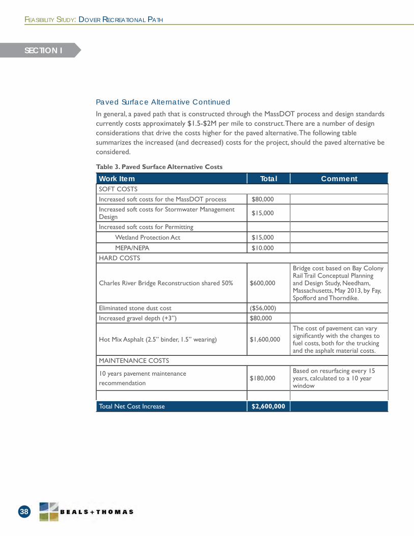
In general, a paved path that is constructed through the MassDOT process and design standards currently costs approximately $1.5-$2M per mile to construct. There are a number of design considerations that drive the costs higher for the paved alternative. The following table summarizes the increased (and decreased) costs for the project, should the paved alternative be considered.
Paved Surface Alternative Continued
FEASIBILITY STUDY: DOVER RECREATIONAL PATH
38
SECTION I
Work Item Total CommentSOFT COSTSIncreased soft costs for the MassDOT process $80,000Increased soft costs for Stormwater Management Design $15,000
Increased soft costs for Permitting
Wetland Protection Act $15,000
MEPA/NEPA $10.000HARD COSTS
Charles River Bridge Reconstruction shared 50% $600,000
Bridge cost based on Bay Colony Rail Trail Conceptual Planning and Design Study, Needham, Massachusetts, May 2013, by Fay, Spofford and Thorndike.
Eliminated stone dust cost ($56,000)Increased gravel depth (+3”) $80,000
Hot Mix Asphalt (2.5” binder, 1.5” wearing) $1,600,000
The cost of pavement can vary signifi cantly with the changes to fuel costs, both for the trucking and the asphalt material costs.
MAINTENANCE COSTS
10 years pavement maintenance recommendation
$180,000Based on resurfacing every 15 years, calculated to a 10 year window
Total Net Cost Increase $2,600,000
Table 3. Paved Surface Alternative Costs
FEASIBILITY STUDY: DOVER RECREATIONAL PATH
39
Guide for the Development of Bicycle Facilities, 2012. Washington, DC: American Association of State Highway and Transportation Offi cials, 2012.
Massachusetts Offi ce of Geographic Information (MassGIS) – used tax parcel boundary data, DEP wetland data, and LiDAR elevation data.
Railroad Valuation Maps provided by Town of Dover, with updated information to 1970, and review of the earlier, clearer original versions obtained online from the University of Connecticut Archives.
Recreational Path Feasibility Study, prepared by Dover Rail Trail Committee, Final Report, dated Spring 2014.
MBTA Draft Lease, with a received date of April 8, 2013 from the Town of Dover.
Wetlands Permitting and Construction Opinion memorandum from Paul McManus, EcoTec, Inc., dated July 24, 2012.
Massachusetts Department of Environmental Protection’s Best Management Practices for Controlling the Exposure to Soil During the Development of Rail Trails.
Dover Wetlands Protection Bylaw, Chapter 181, dated 2005.
National Park Service/ The Impacts of Rail-Trails: A Study of the Users and Property Owners. 1992. http://www.nps.gov/ncrc/programs/rtca/helpfultools/impact_railtrail_fi nal.pdf.
CITATIONS
Reservoir Corporate Center144 Turnpike RoadSouthborough, MA 01772
www.bealsandthomas.com
508.366.0560