Embed Size (px)
Citation preview

Cultural heritage impact assessment for THE PROPOSED SWAZILAND RAIL LINK, WESTERN SECTION,
MPUMALANGA REGION

Cultural Heritage Impact Assessment Swaziland Rail Link, Mpumalanga
i
CULTURAL HERITAGE RESOURCES IMPACT ASSESSMENT FOR THE PROPOSED SWAZILAND RAIL LINK, WESTERN SECTION, MPUMALANGA REGION Report No: 2013/JvS/063 Status: Final Revision No: 0 Date: September 2013 Prepared for: Aurecon Representative: Dr P Botha Postal Address: Aurecon Centre, Lynnwood Bridge Office Park, 4 Daventry St.,
Lynnwood Manor, 0081 Tel: 012 427 2529 E-mail: [email protected] Prepared by: J van Schalkwyk (D Litt et Phil), Heritage Consultant ASAPA Registration No.: 168 Principal Investigator: Iron Age, Colonial Period, Industrial Heritage Postal Address: 62 Coetzer Avenue, Monument Park, 0181 Mobile: 076 790 6777 Fax: 012 347 7270 E-mail: [email protected] Declaration: I, J.A. van Schalkwyk, declare that I do not have any financial or personal interest in the proposed development, nor its developers or any of their subsidiaries, apart from the provision of heritage assessment and management services.
J A van Schalkwyk (D Litt et Phil) Heritage Consultant September 2013

Cultural Heritage Impact Assessment Swaziland Rail Link, Mpumalanga
ii
EXECUTIVE SUMMARY
CULTURAL HERITAGE RESOURCES SCOPING ASSESSMENT FOR THE PROPOSED SWAZILAND RAIL LINK, WESTERN SECTION, MPUMALANGA REGION Currently, much of the coal from the South African inland coalfields is transported via the existing Coal Line through Ermelo to Richards Bay. Transnet commissioned a feasibility study to evaluate the possibility of a rail link from Ermelo utilising the Buhrmanskop - Lothair branch-line to connect with the Swaziland rail network, and eventually to the Port of Richards Bay or Maputo, a strategic rail link with 20t minimum axle loading making the best use of installed infrastructure. In summary, the study identified a technically feasible route between Davel (Dalo) linking into the Swaziland network at Sidvokodvo, provided that the connecting networks are upgraded. Upgrading will involve doubling (in places), new alignments outside the reserve (deviations), and realignment within the reserve and formation repairs on a large scale. The study concluded that the project holds significant advantages in relieving the pressure on the Coal Line, attracting traffic from the Maputo Corridor (longer and heavier traffic), providing a strategic link to export – critical South African export Ports, as well as encouraging economic and rail transport growth in Swaziland. South Africa’s heritage resources, also described as the ’national estate’, comprise a wide range of sites, features, objects and beliefs. According to Section 27(18) of the National Heritage Resources Act (NHRA), Act 25 of 1999, no person may destroy, damage, deface, excavate, alter, remove from its original position, subdivide or change the planning status of any heritage site without a permit issued by the heritage resources authority responsible for the protection of such site.
In accordance with Section 38 of the NHRA, an independent heritage consultant was therefore appointed by Aurecon to conduct a Heritage Impact Assessment (HIA) to determine if any sites, features or objects of cultural heritage significance occur within the boundaries of the area where it is planned to upgrade/develop the railway line. This report deals only with the Mpumalanga section, i.e. from Davel to the Swaziland border. The cultural landscape qualities of the larger region essentially consist of two components. The first is a rural area in which the human occupation is made up of a pre-colonial element (Stone Age and limited Iron Age) as well as a much later colonial (farmer/plantation) component. The second component is an urban landscape dating to the colonial period and is linked to the rural colonial landscape. The following sites, objects and structures of cultural heritage significance were identified:
Old silos adjacent to the railway line and station.
o Dependant on the number of similar structures in the region (according to function, age and architectural features), the feature is viewed to have high significance on a regional level.
o Although this building has been abandoned for some time, it is still in a good state of repair. It is unclear if it would be impacted on by the proposed. If that is to be the case, it should be documented (architectural drawings, descriptions and full photographic documentation) unless such information can be access from Transnet Heritage Foundation. After acceptance of this documentation by SARHA, application for a permit for its destruction can be applied for.

Cultural Heritage Impact Assessment Swaziland Rail Link, Mpumalanga
iii
o If there is no impact on this structure, no further action would be required.
Part of the old station at Estancia. Consists of two semi-detached houses. Probably used as accommodation for the station personnel. The station building, located across the track from this building, has been demolished.
o Dependant on the number of similar structures (according to function, age
and architectural features) in the region, the feature is viewed to have medium significance on a regional level.
o This building is still in a good state of repair. It is unclear if it would be impacted
on by the proposed. If that is to be the case, it should be documented (architectural drawings, descriptions and full photographic documentation) unless such information can be access from Transnet Heritage Foundation. After acceptance of this documentation by SARHA, application for a permit for its destruction can be applied for.
o If there is no impact on the station building, no further action would be required.
The station at Burgerspan. Although the various building have been demolished, the water tanks and water intake point is still standing. This is reminiscent of the by-gone days of steam locomotives.
o Dependant on the number of similar structures (according to function, age
and architectural features) in the region, the feature is viewed to have high significance on a regional level.
o The buildings that made up this station have been demolished and vandalised. The water tanks and water point is still in a good condition. As these features are inside the railway lines, the probability that it would be impacted on is very high. If that is to be the case, it should be documented (architectural drawings, descriptions and full photographic documentation) unless such information can be access from Transnet Heritage Foundation. After acceptance of this documentation by SARHA, application for a permit for its destruction can be applied for.
o If there is no impact on the station building, no further action would be required.
The station building at Lothair. It is still in use and as a result is in a good condition.
o Dependant on the number of similar structures (according to function, age and architectural features) in the region, the feature is viewed to have medium significance on a regional level.
o This building is still in a good state of repair. It is unclear if it would be impacted
on by the proposed. If that is to be the case, it should be documented (architectural drawings, descriptions and full photographic documentation) unless such information can be access from Transnet Heritage Foundation. After acceptance of this documentation by SARHA, application for a permit for its destruction can be applied for.
o If there is no impact on the station building, no further action would be required.
A large number of culverts built with dressed sandstone were identified on all sections of the existing line. Some of these have already being upgraded, being strengthen with concrete.

Cultural Heritage Impact Assessment Swaziland Rail Link, Mpumalanga
iv
o Dependant on the number of similar structures (according to function, age and architectural features) in the region, the feature is viewed to have medium significance on a regional level.
o As these features are inside the railway lines, the probability that it would be
impacted on is very high. If that is to be the case, at least one of each of the different identified types should be documented (architectural drawings, descriptions and full photographic documentation) unless such information can be access from Transnet Heritage Foundation. After acceptance of this documentation by SARHA, application for a permit for its destruction can be applied for.
o If there is no impact on the culverts, no further action would be required.
A three span metal truss bridge across the Vaal River has been identified. At present it is unsure when the bridge was constructed as all the name-plates have been removed, probably by collectors.
o Dependant on the number of similar structures (according to function, age
and architectural features) in the region, the feature is viewed to have high significance on a regional level.
o In all probability this feature is older than 60 years, although it might have been
upgraded in the past. As this feature is inside the railway lines, the probability that it would be impacted on is very high. If that is to be the case, it should be documented (architectural drawings, descriptions and full photographic documentation) unless such information can be access from Transnet Heritage Foundation. After acceptance of this documentation by SARHA, application for a permit for its destruction can be applied for.
o If there is no impact on the culverts, no further action would be required.
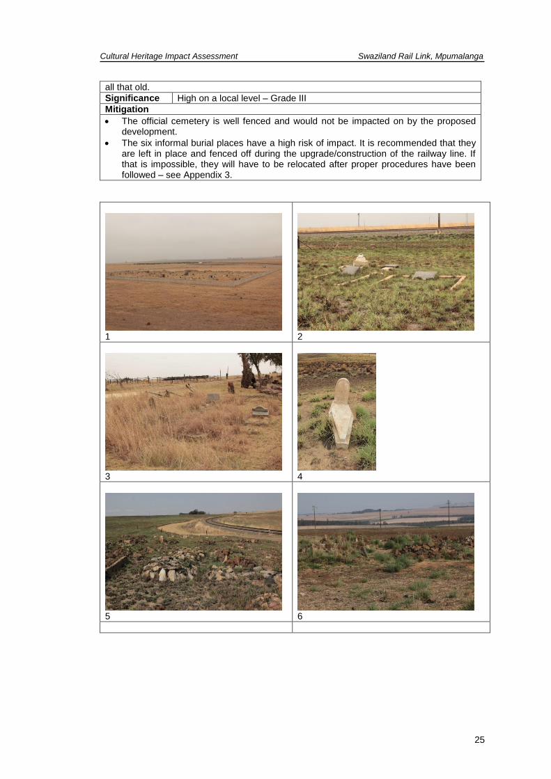
One formal cemetery has been identified. In addition six informal burial places have been identified. The latter six are all located inside or directly adjacent to the railway servitude.
o Dependant on the number of similar features in the region, these burial
places is viewed to have high significance on a local level.
o The official cemetery is well fenced and would not be impacted on by the proposed development.
o The six informal burial places have a high risk of impact. It is recommended that
they are left in place and fenced off during the upgrade/construction of the railway line. If that is impossible, they will have to be relocated after proper procedures have been followed – see Appendix 3.
J A van Schalkwyk Heritage Consultant September 2013

Cultural Heritage Impact Assessment Swaziland Rail Link, Mpumalanga
1
TABLE OF CONTENTS Page
EXECUTIVE SUMMARY ........................................................................................................... II
TABLE OF CONTENTS ............................................................................................................. 1
LIST OF FIGURES ..................................................................................................................... 1
1. INTRODUCTION .................................................................................................................. 4
2. STUDY APPROACH .............................................................................................................. 4
3. HERITAGE RESOURCES .................................................................................................... 7
4. STUDY APPROACH AND METHODOLOGY ..................................................................... 8
5. DESCRIPTION OF THE AFFECTED ENVIRONMENT ...................................................... 9
6. SITE SIGNIFICANCE AND ASSESSMENT ...................................................................... 26
7. CONCLUSIONS ................................................................................................................. 29
8. REFERENCES .................................................................................................................... 32
APPENDIX 1. RELEVANT LEGISLATION .............................................................................. 35
APPENDIX 2: CONVENTIONS USED TO ASSESS THE SIGNIFICANCE OF CULTURAL HERITAGE RESOURCES ....................................................................................................... 36
APPENDIX 3: RELOCATION OF GRAVES ............................................................................ 37
LIST OF FIGURES
Page
Fig. 1. The proposed railway line going through plantations. .................................................... 6
Fig. 2. Example of how the railway line would pass through settled areas. .............................. 6
Fig. 3. Track log of the field survey. ........................................................................................... 9
Fig. 4. The study area in relation to the existing rail network. .................................................. 10
Fig. 5. Different views of the study area................................................................................... 11
Fig. 6. Late Iron Age stone walled sites identified by means of aerial photographs. ............... 14
Fig. 7. “Traditional” Swazi homestead in the former Swazi homeland of KaNgwane. ............. 14
Fig. 8. Outbuildings at an abandoned farmstead adjacent to the railway line. ........................ 15
Fig. 9. Typical farm labourer homestead adjacent to the railway line. ..................................... 16
Fig. 10. The date when the relevant sections of the railway line were developed. ................. 17
Fig. 11. The proposed railway line through Swaziland. ........................................................... 17
Fig. 12. A previous alignment of the railway line in the Davel region. ..................................... 18
Fig. 13. Location of the identified stations................................................................................ 18
Fig. 14. Various identified stations. .......................................................................................... 20
Fig. 15. Location of the culverts on this section of the line. ..................................................... 21
Fig. 16. Types of culverts on this section of the line. ............................................................... 21
Fig. 17. Location of the culverts on this section of the line. ..................................................... 22
Fig. 18. Types of culverts on this section of the line. ............................................................... 23

Cultural Heritage Impact Assessment Swaziland Rail Link, Mpumalanga
2
Fig. 19. Location of the bridge on this section of the line......................................................... 23
Fig. 20. The bridge across the Vaal River ................................................................................ 24
Fig. 21. Location of the identified burial places. ....................................................................... 24
Fig. 22. The identified burial places. ........................................................................................ 26

Cultural Heritage Impact Assessment Swaziland Rail Link, Mpumalanga
3
GLOSSARY OF TERMS AND ABBREVIATIONS
Study area: Refers to the entire study area as indicated by the client in the accompanying Fig. 1 - 2. Stone Age: The first and longest part of human history is the Stone Age, which began with the appearance of early humans between 3-2 million years ago. Stone Age people were hunters, gatherers and scavengers who did not live in permanently settled communities. Their stone tools preserve well and are found in most places in South Africa and elsewhere.
Early Stone Age 2 000 000 - 150 000 Before Present Middle Stone Age 150 000 - 30 000 BP Late Stone Age 30 000 - until c. AD 200
Iron Age: Period covering the last 1800 years, when new people brought a new way of life to southern Africa. They established settled villages, cultivated domestic crops such as sorghum, millet and beans, and they herded cattle as well as sheep and goats. As they produced their own iron tools, archaeologists call this the Iron Age.
Early Iron Age AD 200 - AD 900 Middle Iron Age AD 900 - AD 1300 Late Iron Age AD 1300 - AD 1830
Historical Period: Since the arrival of the white settlers - c. AD 1840 - in this part of the country LIST OF ABBREVIATIONS ADRC Archaeological Data Recording Centre
ASAPA Association of Southern African Professional Archaeologists
EIA Early Iron Age
ESA Early Stone Age
LIA Late Iron Age
LSA Later Stone Age
HIA Heritage Impact Assessment
MSA Middle Stone Age
NASA National Archives of South Africa
NHRA National Heritage Resources Act
PHRA Provincial Heritage Resources Agency
SAHRA South African Heritage Resources Agency

Cultural Heritage Impact Assessment Swaziland Rail Link, Mpumalanga
4
CULTURAL HERITAGE IMPACT ASSESSMENT FOR THE PROPOSED SWAZILAND RAIL LINK, WESTERN SECTION, MPUMALANGA REGION 1. INTRODUCTION Currently, much of the coal from the South African inland coalfields is transported via the existing Coal Line through Ermelo to Richards Bay. Transnet commissioned a feasibility study to evaluate the possibility of a rail link from Ermelo utilising the Buhrmanskop - Lothair branch-line to connect with the Swaziland rail network, and eventually to the Port of Richards Bay or Maputo, a strategic rail link with 20t minimum axle loading making the best use of installed infrastructure. In summary, the study identified a technically feasible route between Davel (Dalo) linking into the Swaziland network at Sidvokodvo, provided that the connecting networks are upgraded. Upgrading will involve doubling (in places), new alignments outside the reserve (deviations), and realignment within the reserve and formation repairs on a large scale. The study concluded that the project holds significant advantages in relieving the pressure on the Coal Line, attracting traffic from the Maputo Corridor (longer and heavier traffic), providing a strategic link to export – critical South African export Ports, as well as encouraging economic and rail transport growth in Swaziland. South Africa’s heritage resources, also described as the ’national estate’, comprise a wide range of sites, features, objects and beliefs. According to Section 27(18) of the National Heritage Resources Act (NHRA), Act 25 of 1999, no person may destroy, damage, deface, excavate, alter, remove from its original position, subdivide or change the planning status of any heritage site without a permit issued by the heritage resources authority responsible for the protection of such site.
In accordance with Section 38 of the NHRA, an independent heritage consultant was therefore appointed by Aurecon to conduct a Heritage Impact Assessment (HIA) to determine if any sites, features or objects of cultural heritage significance occur within the boundaries of the area where it is planned to upgrade/develop the railway line. This report deals only with the Mpumalanga section, i.e. from Davel to the Swaziland border. This HIA report forms part of the Environmental Impact Assessment (EIA) as required by the EIA Regulations in terms of the National Environmental Management Act, 1998 (Act No. 107 of 1998) and is intended for submission to the South African Heritage Resources Agency (SAHRA). 2. STUDY APPROACH
This report does not deal with development projects outside of or even adjacent to the study area as is presented in Section 5 of this report. The same holds true for heritage sites, except in a generalised sense where it is used to create an overview of the heritage potential in the larger region.

Cultural Heritage Impact Assessment Swaziland Rail Link, Mpumalanga
5
2.1 Scope of work The scope of work for this study consisted of:
Conducting of a desk-top investigation of the area, in which all available literature, reports, databases and maps were studied – this material was presented in an earlier scoping report (Van Schalkwyk 2013); and
A visit to the proposed development area. The objectives were to
Identify possible archaeological, cultural and historic sites within the proposed development area;
Evaluate the potential impacts of construction, operation and maintenance of the proposed development on archaeological, cultural and historical resources;
Recommend mitigation measures to ameliorate any negative impacts on areas of archaeological, cultural or historical importance.
2.2 Limitations The investigation has been influenced by the following factors:
The unpredictability of archaeological remains occurring below the surface.
Even though a number of publications dealing with aspects of the heritage of this region appeared recently, very little published information regarding the location of heritage sites exists;
The knowledge on location of heritage sites is largely informed by development projects. Areas where there is not much development, is therefore under researched.
In the east the large-scale development of plantations might have had a devastating effect on heritage resources in an era prior to their legislative protection. The dense tree cover also makes the detection of possible sites very difficult (e.g. Fig. 1).
In other areas the proposed line cut through rural communities (e.g. Fig. 2). As no information on public participation with regard to the development of the railway line is available, it was difficult to access these areas as the concern is that questions in this regard might lead to the development of unnecessary stress, and therefore resistance, in these communities.
2.3 Assumptions
It is assumed that a Paleontological Review will be done by a suitably qualified specialist.

Cultural Heritage Impact Assessment Swaziland Rail Link, Mpumalanga
6
Fig. 1. The proposed railway line going through plantations. (Photo: Google Earth)
Fig. 2. Example of how the railway line would pass through settled areas. (Photo: Google Earth)

Cultural Heritage Impact Assessment Swaziland Rail Link, Mpumalanga
7
3. HERITAGE RESOURCES 3.1 The National Estate The NHRA (No. 25 of 1999) defines the heritage resources of South Africa which are of cultural significance or other special value for the present community and for future generations that must be considered part of the national estate to include:
places, buildings, structures and equipment of cultural significance;
places to which oral traditions are attached or which are associated with living heritage;
historical settlements and townscapes;
landscapes and natural features of cultural significance;
geological sites of scientific or cultural importance;
archaeological and palaeontological sites;
graves and burial grounds, including- o ancestral graves; o royal graves and graves of traditional leaders; o graves of victims of conflict; o graves of individuals designated by the Minister by notice in the Gazette; o historical graves and cemeteries; and o other human remains which are not covered in terms of the Human Tissue Act,
1983 (Act No. 65 of 1983);
sites of significance relating to the history of slavery in South Africa;
movable objects, including- o objects recovered from the soil or waters of South Africa, including archaeological
and palaeontological objects and material, meteorites and rare geological specimens;
o objects to which oral traditions are attached or which are associated with living heritage;
o ethnographic art and objects; o military objects; o objects of decorative or fine art; o objects of scientific or technological interest; and o books, records, documents, photographic positives and negatives, graphic, film
or video material or sound recordings, excluding those that are public records as defined in section 1(xiv) of the National Archives of South Africa Act, 1996 (Act No. 43 of 1996).
3.2 Cultural significance In the NHRA, Section 2 (vi), it is stated that ‘‘cultural significance’’ means aesthetic, architectural, historical, scientific, social, spiritual, linguistic or technological value or significance. This is determined in relation to a site or feature’s uniqueness, condition of preservation and research potential. According to Section 3(3) of the NHRA, a place or object is to be considered part of the national estate if it has cultural significance or other special value because of
its importance in the community, or pattern of South Africa's history;
its possession of uncommon, rare or endangered aspects of South Africa's natural or cultural heritage;
its potential to yield information that will contribute to an understanding of South Africa's natural or cultural heritage;
its importance in demonstrating the principal characteristics of a particular class of South Africa's natural or cultural places or objects;

Cultural Heritage Impact Assessment Swaziland Rail Link, Mpumalanga
8
its importance in exhibiting particular aesthetic characteristics valued by a community or cultural group;
its importance in demonstrating a high degree of creative or technical achievement at a particular period;
its strong or special association with a particular community or cultural group for social, cultural or spiritual reasons;
its strong or special association with the life or work of a person, group or organisation of importance in the history of South Africa; and
sites of significance relating to the history of slavery in South Africa.
A matrix was developed whereby the above criteria were applied for the determination of the significance of each identified site (see Appendix 2). This allowed some form of control over the application of similar values for similar identified sites.
4. STUDY APPROACH AND METHODOLOGY 4.1 Extent of the Study This survey and impact assessment covers the area as presented in Section 5 and as illustrated in Figures 2 & 4. 4.2 Methodology 4.2.1 Survey of the literature A survey of the relevant literature was conducted with the aim of reviewing the previous research done and determining the potential of the area. In this regard, various reports, anthropological, archaeological and historical sources were consulted. Two publications stand out. In 1906 L.V. Praagh produced his encyclopaedic work, The Transvaal and its Mines. In this publication he give detailed information of the state of development in the region, as well as discussing topics such as geology, ethnography, zoology, etc. This source serves as baseline for determining heritage features dating to colonial times. The other, more recent source is the work of Delius (2007), Mpumalanga: History and Heritage, which is an effort to produce a more inclusive view on the history of the region. It was later reworked into a more popular format Delius & Hay (2009).
Information on events, sites and features in the larger region were obtained from these sources.
4.2.2 Databases The Heritage Sites Database and the Environmental Potential Atlas was consulted. Some documents were tracked down in the various databases of the National Archives of South Africa (NASA), especially in the SAB and TAB holdings. Other sources include the Chief Surveyor General, and the various lists produced by the South African Heritage Resources Agency (SAHRA).

Cultural Heritage Impact Assessment Swaziland Rail Link, Mpumalanga
9
Database surveys produced a number of sites located in the larger region of the proposed development.
4.2.3 Other sources Topocadastral and other maps were also studied - see the list of references below. Aerial photographs, where available, were used. 4.2.2 Field survey The area that had to be investigated was identified by Aurecon Consulting Engineers by means of maps and .kmz files. As this is a linear development and it follows the existing railway line over most of the distance, the survey was conducted by following the existing and proposed line as close as possible. The section where there is no railway track yet was accessed on foot. This excluded the areas which were covered with pine trees (see Section 2.2. above) – see the track log of the site survey presented in Fig. 3. The field survey was conducted on two days: 23 September 2013 and 3 October 2013.
Fig. 3. Track log of the field survey. 5. DESCRIPTION OF THE AFFECTED ENVIRONMENT 5.1 Site location The study area is a linear development running from Davel in Mpumalanga, via Sidvokdvo in Swaziland to the deep water port of Richards Bay. This report deals only with the Mpumalanga section, i.e. from Davel to the Swaziland border.

Cultural Heritage Impact Assessment Swaziland Rail Link, Mpumalanga
10
The topography of the study area can be described as grassland, changing from slightly undulating plains in to west, to undulating hills and lowlands. Most of the grassland has disappeared due to agricultural, forestry and mining activities. The average height above sea level is approximately 1400 m. Some of the larger perennial rivers crossing the area are the Waterval, Vaal, Ngwempisi and Phongola Rivers. 5.2 Development proposal The routing for the study includes the following areas and is depicted below in Figure 3 below.
Davel to Breyton (incl. the re-establishment of the link between Estansia and Breyton)
Breyton to Burmanskop
Burmanskop to Lothair (i.e. the Lothair branchline)
Lothair to KaDake to Matsapha – new alignment
Lothair to Matsapha – new alignment
Matsapha to Phuzumoya
Phuzumoya to Beluluane (Maputo)
Phuzumoya to Golela
Golela to Nsese (Richard’s Bay)
Fig. 4. The study area in relation to the existing rail network.

Cultural Heritage Impact Assessment Swaziland Rail Link, Mpumalanga
11
1
2
3
4
5
6
7
8
Fig. 5. Different views of the study area.

Cultural Heritage Impact Assessment Swaziland Rail Link, Mpumalanga
12
5.3 Overview of the cultural heritage of the region 5.3.1 Stone Age The larger region has been inhabited by humans since Early Stone Age (ESA) times. Tools dating to this period are mostly, although not exclusively, found in the vicinity of watercourses. The original dating and evolutionary scheme for the development of tools during this early period, was based on a study of the river terrace gravels of the Vaal River in the Vereeniging region, referred to as the Older, the Younger and the Youngest gravels (Söhnge, Visser & Van Riet-Lowe1937; Breuil 1948). However, on subsequent investigation, the findings derived from this proved to be unacceptable as it was based on incorrect interpretations of the river gravels. It was only with the excavation of similar material from sealed, stratified sites, that it was realised that the material from the river gravels was not in is its primary context, having been uncovered and washed about over many millennia. Consequently, artefacts derived from such surface collections are now seen to have little significance. The oldest of these tools are known as choppers, crudely produced from large pebbles found in the river. Later, Homo erectus and early Homo sapiens people made tools shaped on both sides, called bifaces. Biface technology is known as the Acheulean tradition, from St Acheul in France, where bifaces were first identified in the mid-19th century. During Middle Stone Age (MSA) times (c. 150 000 – 30 000 BP), people became more mobile, occupying areas formerly avoided. According to Thakeray (1992) the MSA is a period that still remains somewhat murky, as much of the MSA lies beyond the limits of conventional radiocarbon dating. However, the concept of the MSA remains useful as a means of identifying a technological stage characterized by flakes and flake-blades with faceted platforms, produced from prepared cores, as distinct from the core tool-based ESA technology. Open sites were still preferred near watercourses. These people were adept at exploiting the huge herds of animals that passed through the area, on their seasonal migration. As a result, tools belonging to this period also mostly occur in the open or in erosion dongas. Similar to the ESA material, artefacts from these surface collections are viewed not to be in a primary context and have little or no significance. Late Stone Age (LSA) people had even more advanced technology than the MSA people and therefore succeeded in occupying even more diverse habitats. Also, for the first time we now get evidence of people’s activities derived from material other than stone tools. Ostrich eggshell beads, ground bone arrowheads, small bored stones and wood fragments with incised markings are traditionally linked with the LSA. LSA people preferred, though not exclusively, to occupy rock shelters and caves and it is this type of sealed context that make it possible for us to learn much more about them than is the case with earlier periods. A number of sites with rock art are known from the Chrissiesmeer region. 5.3.2 Iron Age Iron Age people started to settle in southern Africa c. AD 300, with one of the oldest known site at Silver Leaves south east of Tzaneen dating to AD 270. Having only had cereals (sorghum, millet) that need summer rainfall, Early Iron Age (EIA) people did not move outside this rainfall zone, and neither did they occupy the central interior highveld area. Because of their specific technology and economy, Iron Age people preferred to settle on the alluvial soils near rivers for agricultural purposes, but also for firewood and water. The occupation of the larger geographical area (including the study area) did not start much before the 1500s. To understand all of this, we have to take a look at the broader picture.

Cultural Heritage Impact Assessment Swaziland Rail Link, Mpumalanga
13
Towards the end of the first millennium AD, Early Iron Age communities underwent a drastic change, brought on by increasing trade on the East African coast. This led to the rise of powerful ruling elites, for example at Mapungubwe. The abandonment of Mapungubwe (c. AD 1270) and other contemporaneous settlements show that widespread drought conditions led to the decline and eventual disintegration of this state Huffman (2005). By the 16th century things changed again, with the climate becoming warmer and wetter, creating condition that allowed Late Iron Age (LIA) farmers to occupy areas previously unsuitable, for example the Witwatersrand and the treeless, wind swept plains of the Free State and the Mpumalanga highveld. This period of consistently high rainfall started in about AD 1780. At the same time, maize was introduced from Maputo and grown extensively. Given good rains, maize crops yield far more than sorghum and millets. This increase in food production probably led to increased populations in coastal area as well as the central highveld interior by the beginning of the 19th century. This wet period came to a sudden end sometime between 1800 and 1820 by a major drought lasting 3 to 5 years. The drought must have caused an agricultural collapse on a large, subcontinent scale. This was also a period of great military tension. Armed Griqua and Korana raiders on horseback were active in the northern Cape and Orange Free State by about 1790. The Xhosa were raiding across the Orange River about 1805. Military pressure from Zululand spilled onto the highveld by at least 1821. Various marauding groups of displaced Sotho-Tswana moved across the plateau in the 1820s. Mzilikazi raided the plateau extensively between 1825 and 1837. The Boers trekked into this area in the 1830s. Due to their specific settlement requirements, Late Iron Age people preferred to settle on the steep slope of a mountain, possibly for protection, or for cultural considerations such as grazing for their enormous cattle herds. Because of the lack of trees they built their settlements in stone. A number of stone-walled archaeological sites, which are dated to the Late Iron Age (c. AD 1640 - AD 1830s), were identified west of the study area, and some of them have been excavated (Taylor 1979, Pelser et al 2007) (Fig. 6). These sites are conventionally associated with Tswana-speaking people. 5.3.3 Ethno-history Whereas it is impossible to correlate any living group of people to Early Iron Age communities, it is possible, by using ethnographic evidence, to identify some of the groups of people that entered the region in pre-colonial times (i.e. the Later Iron Age) and are currently settled in the larger region. The Tswana-speakers were located to the south and west in the study area, with the Ndzundza Ndebele (Nguni-speakers) to the north. The eastern section of the study area was occupied by Swazi-speakers (Fig. 7), also of Nguni origin.

Cultural Heritage Impact Assessment Swaziland Rail Link, Mpumalanga
14
Fig. 6. Late Iron Age stone walled sites identified by means of aerial photographs. (Photo: Google Earth).
Fig. 7. “Traditional” Swazi homestead in the former Swazi homeland of KaNgwane. (Photo: Google Earth)

Cultural Heritage Impact Assessment Swaziland Rail Link, Mpumalanga
15
5.3.4 Historic period Things were set to change drastically during the early part of the 19
th century. Not only was it
a time of population movement resulting from events to the south and east, but it was also the arrival of the first white settlers in the area. Currently, a large number of towns exist in the area, with Balfour, Secunda, Standerton and Piet Retief the larger ones. All of these date to the latter half of the 19
th century and each has
its own history as each developed for a particular reason. As they were small and largely served farming communities, they did not expand rapidly. Consequently, all of them retained many buildings (shops, houses, churches, schools) and other features (cemeteries) of heritage significance. The various battles and skirmishes resulting from the conflict during the Anglo-Boer War (1899-1902) had a huge impact on heritage resources in the area, as many farms were burned down. Conversely, it also left a legacy of heritage sites scattered across the veld: fortifications and war cemeteries occur all over. Although most of the conflict centred on the railway line to Lourenço Marques (Maputo), located to the north, incidents also took place in other areas, e.g. Bakenlaagte (Cloete 2000). However, the area remained up till today, a largely farming orientated community. Much of the heritage potential of the study area is therefore located within the many farmsteads in the area. Farmhouses and related structures (e.g. barns, sheds, etc.), as well as cemeteries, dot the landscape. Equally important, are the homesteads, related structures and cemeteries of the farm labourers living on these farms. Industrial and mining activities also took place in the region, on an ever increasing scale. Coal mining dates to the beginning of the 20
th century, although there is written evidence that it
was exploited by farmers prior to that. Forestry also became a big operation, going back as far as the early 1900s.
Fig. 8. Outbuildings at an abandoned farmstead adjacent to the railway line.

Cultural Heritage Impact Assessment Swaziland Rail Link, Mpumalanga
16
Fig. 9. Typical farm labourer homestead adjacent to the railway line. 5.3.5 The existing railway line The history of railway development in South Africa is very much in tandem with similar events throughout the world. However, the discovery of diamonds and gold gave big impetus to the development various lines, all of which played out in the context of nationalism, colonial dominance and greed (Van Schalkwyk in preparation). The main thrust of these developments was to find the shortest and least expensive route towards the coast and the available ports. The Pretoria – Lourenço Marques (Maputo) line, the Cape Town via Bloemfontein to Johannesburg and the Durban via Charlestown to Johannesburg line all developed as a result. Sections of the existing line were constructed in 1905 (Bethal to Breyten) and the section from Breyten southwards via Piet Retief in 1908. The section from Ermelo to Lothair was completed in 1925 (Fig. 10). As shorter alternative, linking Breyten to Lourenço Marques, via Bremersdorp in Swaziland was already proposed in 1922, but never constructed (Fig. 11). Undoubtedly sections of these early lines have been upgraded over time. This is for example noticeable in the change of alignments (e.g. Fig. 12) as well as in the heightening and strengthening of some of the smaller culverts. In addition dates ranging between 1936 to 1973 were noticed on some of the rails that were laid in the track.

Cultural Heritage Impact Assessment Swaziland Rail Link, Mpumalanga
17
Fig. 10. The date when the relevant sections of the railway line were developed. (Map: South African Railways 1925)
Fig. 11. The proposed railway line through Swaziland.

Cultural Heritage Impact Assessment Swaziland Rail Link, Mpumalanga
18
Fig. 12. A previous alignment of the railway line in the Davel region. (Photo: Google Earth) 5.4 Identified sites The following sites and features of cultural heritage significance were identified. Attention was given to the existing servitude as well as to the areas where new development is to take place. In addition, sites located in close proximity of the servitude were also included as a pro-active measure to prevent possible future damage. 5.4.1 Stations
Fig. 13. Location of the identified stations.

Cultural Heritage Impact Assessment Swaziland Rail Link, Mpumalanga
19
NHRA Category Buildings, structures, places and equipment of cultural significance
Protection status
General Protection - Section 34: Structures older than 60 years
Location No. 1 No. 2 No. 3 No. 4
S 26.44110 S 26.33651 S 26.45863 S 26.39239
E 29.67070 E 29.87956 E 30.17245 E 30.43188
Description
No. 1: Old silos adjacent to the railway line and station. This type of silo was developed during the 1940s. It is an all concrete structure. Although it has been abandoned when a larger, more modern facility was constructed some distance away, it is still in a sound condition. No. 2: Part of the old station at Estancia. Consists of two semi-detached houses. Probably used as accommodation for the station personnel. It is currently being used as a school. The station building, located across the track from this building, has been demolished. No. 3: The station at Burgerspan. Although the various building have been demolished, the water tanks and water intake point is still standing. This is reminiscent of the by-gone days of steam locomotives. No.4: The station building at Lothair. It is still in use and as a result is in a good condition
Significance Medium/high on a regional level – Grade III
Mitigation
No. 1: Although this building has been abandoned for some time, it is still in a good state of repair. It is unclear if it would be impacted on by the proposed. If that is to be the case, it should be documented (architectural drawings, descriptions and full photographic documentation) unless such information can be access from Transnet Heritage Foundation. After acceptance of this documentation by SARHA, application for a permit for its destruction can be applied for.
If there is no impact on this structure, no further action would be required. No. 2: This building is still in a good state of repair. It is unclear if it would be impacted on by the proposed. If that is to be the case, it should be documented (architectural drawings, descriptions and full photographic documentation) unless such information can be access from Transnet Heritage Foundation. After acceptance of this documentation by SARHA, application for a permit for its destruction can be applied for.
If there is no impact on the station building, no further action would be required. No. 3: The buildings that made up this station have been demolished and vandalised. The water tanks and water point is still in a good condition. As these features are inside the railway lines, the probability that it would be impacted on is very high. If that is to be the case, it should be documented (architectural drawings, descriptions and full photographic documentation) unless such information can be access from Transnet Heritage Foundation. After acceptance of this documentation by SARHA, application for a permit for its destruction can be applied for.
If there is no impact on the station building, no further action would be required. No. 4: This building is still in a good state of repair. It is unclear if it would be impacted on by the proposed. If that is to be the case, it should be documented (architectural drawings, descriptions and full photographic documentation) unless such information can be access from Transnet Heritage Foundation. After acceptance of this documentation by SARHA, application for a permit for its destruction can be applied for.

Cultural Heritage Impact Assessment Swaziland Rail Link, Mpumalanga
20
If there is no impact on the station building, no further action would be required.
1
2
3
4
Fig. 14. Various identified stations. 5.4.2 Culverts
NHRA Category Buildings, structures, places and equipment of cultural significance
Protection status
General Protection - Section 34: Structures older than 60 years
Davel - Breyten Section

Cultural Heritage Impact Assessment Swaziland Rail Link, Mpumalanga
21
Fig. 15. Location of the culverts on this section of the line.
Location Davel - Breyten Section
Description
Approximately 20 culverts were identified on this section of the line. Some of these have already being upgraded, being strengthen with concrete. Three different versions were identified:
A large single span sandstone culvert, that, due to earlier realignment of the line, is now located some distance off the existing line;
Small single span culverts of dressed sandstone;
Small two span culverts of dressed sandstone.
Significance Medium on a regional level – Grade III
Mitigation
As these features are inside the railway lines, the probability that it would be impacted on is very high. If that is to be the case, at least one of each of the two types should be documented (architectural drawings, descriptions and full photographic documentation) unless such information can be access from Transnet Heritage Foundation. After acceptance of this documentation by SARHA, application for a permit for its destruction can be applied for.
If there is no impact on the culverts, no further action would be required.
1
2
3
Fig. 16. Types of culverts on this section of the line.

Cultural Heritage Impact Assessment Swaziland Rail Link, Mpumalanga
22
Breyten - Ermelo Section
Location Breyten - Ermelo Section
Description
Approximately 5 culverts were identified on this section of the line. Some of these have already being upgraded, being strengthen or having being rebuilt. Two different versions were identified:
Small single span culverts of dressed sandstone.
Small single span culverts of dressed sandstone, into which have been inserted a pre-cast concrete pipe
Significance Medium on a regional level – Grade III
Mitigation
As these features are inside the railway lines, the probability that it would be impacted on is very high. If that is to be the case, at least one of each of the two types should be documented (architectural drawings, descriptions and full photographic documentation) unless such information can be access from Transnet Heritage Foundation. After acceptance of this documentation by SARHA, application for a permit for its destruction can be applied for.
If there is no impact on the culverts, no further action would be required.
Fig. 17. Location of the culverts on this section of the line.

Cultural Heritage Impact Assessment Swaziland Rail Link, Mpumalanga
23
Fig. 18. Types of culverts on this section of the line. 5.4.3 Bridges
Fig. 19. Location of the bridge on this section of the line.
NHRA Category Buildings, structures, places and equipment of cultural significance
Protection status
General Protection - Section 34: Structures older than 60 years
Location No. 1 S 26.45817 E 30.19306
Description
A three span metal truss bridge across the Vaal River. At present it is unsure when the bridge was constructed as all the name-plates have been removed, probably by collectors. The arched trussed for stabilizing the main section of the bridge is typical of what was developed for railway lines during the1940s and 1950s.
Significance High on a regional level – Grade III
Mitigation
In all probability this feature is older than 60 years, although it might have been upgraded in the past. As this feature is inside the railway lines, the probability that it would be impacted on is very high. If that is to be the case, it should be documented (architectural drawings, descriptions and full photographic documentation) unless such information can be access from Transnet Heritage Foundation. After acceptance of this documentation by SARHA, application for a permit for its destruction can be applied for.
If there is no impact on the culverts, no further action would be required.

Cultural Heritage Impact Assessment Swaziland Rail Link, Mpumalanga
24
Fig. 20. The bridge across the Vaal River 5.4.4 Burial places
Fig. 21. Location of the identified burial places.
NHRA Category Graves, cemeteries and burial grounds
Protection status
General Protection - Section 36: Graves or burial grounds
Location No. 1 No. 2 No. 3 No. 4 No. 5 No. 6 No. 7
S 26.45622 S 26.41601 S 26.35478 S 26.33783 S 26.43225 S 26.46697 S 26.41552
E 29.65954 E 29.67123 E 29.80725 E 29.88290 E 30.01639 E 30.06063 E 30.31988
Description
One formal cemetery (No. 1 above) has been identified. In addition six informal burial places (No. 2 – 7) have been identified. The latter six are all located inside or directly adjacent to the railway servitude. They range in size from a single grave to as many as fifty. Headstone on some of the graves indicates that they are older than 60 years. In most cases the graves are only marked with stone cairns, making it difficult to determine there age. However, it was also notes that some of the graves have recently been cleaned, indicating that they are still visited by family, which might be an indication that they are not
Cultural Heritage Impact Assessment Swaziland Rail Link, Mpumalanga
25
all that old.
Significance High on a local level – Grade III
Mitigation
The official cemetery is well fenced and would not be impacted on by the proposed development.
The six informal burial places have a high risk of impact. It is recommended that they are left in place and fenced off during the upgrade/construction of the railway line. If that is impossible, they will have to be relocated after proper procedures have been followed – see Appendix 3.
1
2
3
4
5
6

Cultural Heritage Impact Assessment Swaziland Rail Link, Mpumalanga
26
7
Fig. 22. The identified burial places. 6. SITE SIGNIFICANCE AND ASSESSMENT 6.1 Heritage assessment criteria and grading The NHRA stipulates the assessment criteria and grading of archaeological sites. The following categories are distinguished in Section 7 of the Act:
Grade I: Heritage resources with qualities so exceptional that they are of special national significance;
Grade II: Heritage resources which, although forming part of the national estate, can be considered to have special qualities which make them significant within the context of a province or a region; and
Grade III: Other heritage resources worthy of conservation on a local authority level. The occurrence of sites with a Grade I significance will demand that the development activities be drastically altered in order to retain these sites in their original state. For Grade II and Grade III sites, the applicable of mitigation measures would allow the development activities to continue. Sites regarded as having low significance is viewed as recorded in full after identification and would require no further mitigation. Impact from the development would be judged to be low. Sites with a medium to high significance would require mitigation. Mitigation, in most cases the excavation of a site, is in essence destructive and therefore the impact can be viewed as high and as permanent. 6.2 Statement of significance Based on current information regarding sites in the surrounding area, all sites expected to occur in the study region are judged to have Grade III significance and therefore would not prevent the proposed development for continuing after the implementation of the proposed mitigation measures and its acceptance by SAHRA.

Cultural Heritage Impact Assessment Swaziland Rail Link, Mpumalanga
27
Table 1. Summary of identified heritage resources.
Identified heritage resources
Category, according to NHRA Identification/Description
Formal protections (NHRA)
National heritage site (Section 27) None
Provincial heritage site (Section 27) None
Provisional protection (Section 29) None
Place listed in heritage register (Section 30) None
General protections (NHRA)
structures older than 60 years (Section 34) Yes
archaeological site or material (Section 35) None
palaeontological site or material (Section 35) None
graves or burial grounds (Section 36) Yes
public monuments or memorials (Section 37) None
Other
Any other heritage resources (describe) None
6.3 Impact assessment Impact analysis of cultural heritage resources under threat of the proposed development, are based on the present understanding of the development. Based on current knowledge and understanding of the area, one can evaluate the heritage sites in the area as follows:
Old silos adjacent to the railway line and station.
o Dependant on the number of similar structures in the region (according to function, age and architectural features), the feature is viewed to have high significance on a regional level.
o Although this building has been abandoned for some time, it is still in a good state of repair. It is unclear if it would be impacted on by the proposed. If that is to be the case, it should be documented (architectural drawings, descriptions and full photographic documentation) unless such information can be access from Transnet Heritage Foundation. After acceptance of this documentation by SARHA, application for a permit for its destruction can be applied for.
o If there is no impact on this structure, no further action would be required.
Part of the old station at Estancia. Consists of two semi-detached houses. Probably used as accommodation for the station personnel. The station building, located across the track from this building, has been demolished.
o Dependant on the number of similar structures (according to function, age
and architectural features) in the region, the feature is viewed to have medium significance on a regional level.

Cultural Heritage Impact Assessment Swaziland Rail Link, Mpumalanga
28
o This building is still in a good state of repair. It is unclear if it would be impacted on by the proposed. If that is to be the case, it should be documented (architectural drawings, descriptions and full photographic documentation) unless such information can be access from Transnet Heritage Foundation. After acceptance of this documentation by SARHA, application for a permit for its destruction can be applied for.
o If there is no impact on the station building, no further action would be required.
The station at Burgerspan. Although the various building have been demolished, the water tanks and water intake point is still standing. This is reminiscent of the by-gone days of steam locomotives.
o Dependant on the number of similar structures (according to function, age
and architectural features) in the region, the feature is viewed to have high significance on a regional level.
o The buildings that made up this station have been demolished and vandalised. The water tanks and water point is still in a good condition. As these features are inside the railway lines, the probability that it would be impacted on is very high. If that is to be the case, it should be documented (architectural drawings, descriptions and full photographic documentation) unless such information can be access from Transnet Heritage Foundation. After acceptance of this documentation by SARHA, application for a permit for its destruction can be applied for.
o If there is no impact on the station building, no further action would be required.
The station building at Lothair. It is still in use and as a result is in a good condition.
o Dependant on the number of similar structures (according to function, age and architectural features) in the region, the feature is viewed to have medium significance on a regional level.
o This building is still in a good state of repair. It is unclear if it would be impacted
on by the proposed. If that is to be the case, it should be documented (architectural drawings, descriptions and full photographic documentation) unless such information can be access from Transnet Heritage Foundation. After acceptance of this documentation by SARHA, application for a permit for its destruction can be applied for.
o If there is no impact on the station building, no further action would be required.
A large number of culverts built with dressed sandstone were identified on all sections of the existing line. Some of these have already being upgraded, being strengthen with concrete.
o Dependant on the number of similar structures (according to function, age
and architectural features) in the region, the feature is viewed to have medium significance on a regional level.
o As these features are inside the railway lines, the probability that it would be
impacted on is very high. If that is to be the case, at least one of each of the different identified types should be documented (architectural drawings, descriptions and full photographic documentation) unless such information can be access from Transnet Heritage Foundation. After acceptance of this documentation by SARHA, application for a permit for its destruction can be applied for.

Cultural Heritage Impact Assessment Swaziland Rail Link, Mpumalanga
29
o If there is no impact on the culverts, no further action would be required.
A three span metal truss bridge across the Vaal River has been identified. At present it is unsure when the bridge was constructed as all the name-plates have been removed, probably by collectors.
o Dependant on the number of similar structures (according to function, age
and architectural features) in the region, the feature is viewed to have high significance on a regional level.
o In all probability this feature is older than 60 years, although it might have been
upgraded in the past. As this feature is inside the railway lines, the probability that it would be impacted on is very high. If that is to be the case, it should be documented (architectural drawings, descriptions and full photographic documentation) unless such information can be access from Transnet Heritage Foundation. After acceptance of this documentation by SARHA, application for a permit for its destruction can be applied for.
o If there is no impact on the culverts, no further action would be required.
One formal cemetery has been identified. In addition six informal burial places have been identified. The latter six are all located inside or directly adjacent to the railway servitude.
o Dependant on the number of similar features in the region, these burial
places is viewed to have high significance on a local level.
o The official cemetery is well fenced and would not be impacted on by the proposed development.
o The six informal burial places have a high risk of impact. It is recommended that
they are left in place and fenced off during the upgrade/construction of the railway line. If that is impossible, they will have to be relocated after proper procedures have been followed – see Appendix 3.
7. CONCLUSIONS The aim of the survey was to locate, identify, evaluate and document sites, objects and structures of cultural heritage significance found within the area in which it is proposed to upgrade/develop the railway line. The cultural landscape qualities of the larger region essentially consist of two components. The first is a rural area in which the human occupation is made up of a pre-colonial element (Stone Age and limited Iron Age) as well as a much later colonial (farmer/plantation) component. The second component is an urban landscape dating to the colonial period and is linked to the rural colonial landscape. The following sites, objects and structures of cultural heritage significance were identified:
Old silos adjacent to the railway line and station.
o Dependant on the number of similar structures in the region (according to function, age and architectural features), the feature is viewed to have high significance on a regional level.

Cultural Heritage Impact Assessment Swaziland Rail Link, Mpumalanga
30
o Although this building has been abandoned for some time, it is still in a good state of repair. It is unclear if it would be impacted on by the proposed. If that is to be the case, it should be documented (architectural drawings, descriptions and full photographic documentation) unless such information can be access from Transnet Heritage Foundation. After acceptance of this documentation by SARHA, application for a permit for its destruction can be applied for.
o If there is no impact on this structure, no further action would be required.
Part of the old station at Estancia. Consists of two semi-detached houses. Probably used as accommodation for the station personnel. The station building, located across the track from this building, has been demolished.
o Dependant on the number of similar structures (according to function, age
and architectural features) in the region, the feature is viewed to have medium significance on a regional level.
o This building is still in a good state of repair. It is unclear if it would be impacted
on by the proposed. If that is to be the case, it should be documented (architectural drawings, descriptions and full photographic documentation) unless such information can be access from Transnet Heritage Foundation. After acceptance of this documentation by SARHA, application for a permit for its destruction can be applied for.
o If there is no impact on the station building, no further action would be required.
The station at Burgerspan. Although the various building have been demolished, the water tanks and water intake point is still standing. This is reminiscent of the by-gone days of steam locomotives.
o Dependant on the number of similar structures (according to function, age
and architectural features) in the region, the feature is viewed to have high significance on a regional level.
o The buildings that made up this station have been demolished and vandalised. The water tanks and water point is still in a good condition. As these features are inside the railway lines, the probability that it would be impacted on is very high. If that is to be the case, it should be documented (architectural drawings, descriptions and full photographic documentation) unless such information can be access from Transnet Heritage Foundation. After acceptance of this documentation by SARHA, application for a permit for its destruction can be applied for.
o If there is no impact on the station building, no further action would be required.
The station building at Lothair. It is still in use and as a result is in a good condition.
o Dependant on the number of similar structures (according to function, age and architectural features) in the region, the feature is viewed to have medium significance on a regional level.
o This building is still in a good state of repair. It is unclear if it would be impacted
on by the proposed. If that is to be the case, it should be documented (architectural drawings, descriptions and full photographic documentation) unless such information can be access from Transnet Heritage Foundation. After acceptance of this documentation by SARHA, application for a permit for its destruction can be applied for.
o If there is no impact on the station building, no further action would be required.

Cultural Heritage Impact Assessment Swaziland Rail Link, Mpumalanga
31
A large number of culverts built with dressed sandstone were identified on all sections of the existing line. Some of these have already being upgraded, being strengthen with concrete.
o Dependant on the number of similar structures (according to function, age
and architectural features) in the region, the feature is viewed to have medium significance on a regional level.
o As these features are inside the railway lines, the probability that it would be
impacted on is very high. If that is to be the case, at least one of each of the different identified types should be documented (architectural drawings, descriptions and full photographic documentation) unless such information can be access from Transnet Heritage Foundation. After acceptance of this documentation by SARHA, application for a permit for its destruction can be applied for.
o If there is no impact on the culverts, no further action would be required.
A three span metal truss bridge across the Vaal River has been identified. At present it is unsure when the bridge was constructed as all the name-plates have been removed, probably by collectors.
o Dependant on the number of similar structures (according to function, age
and architectural features) in the region, the feature is viewed to have high significance on a regional level.
o In all probability this feature is older than 60 years, although it might have been
upgraded in the past. As this feature is inside the railway lines, the probability that it would be impacted on is very high. If that is to be the case, it should be documented (architectural drawings, descriptions and full photographic documentation) unless such information can be access from Transnet Heritage Foundation. After acceptance of this documentation by SARHA, application for a permit for its destruction can be applied for.
o If there is no impact on the culverts, no further action would be required.
One formal cemetery has been identified. In addition six informal burial places have been identified. The latter six are all located inside or directly adjacent to the railway servitude.
o Dependant on the number of similar features in the region, these burial
places is viewed to have high significance on a local level.
o The official cemetery is well fenced and would not be impacted on by the proposed development.
o The six informal burial places have a high risk of impact. It is recommended that
they are left in place and fenced off during the upgrade/construction of the railway line. If that is impossible, they will have to be relocated after proper procedures have been followed – see Appendix 3.

Cultural Heritage Impact Assessment Swaziland Rail Link, Mpumalanga
32
8. REFERENCES 8.1 Data bases Chief Surveyor General Environmental Potential Atlas, Department of Environmental Affairs and Tourism. Heritage Atlas Database, Pretoria. National Archives of South Africa 8.2 Literature Acocks, J.P.H. 1975. Veld Types of South Africa. Memoirs of the Botanical Survey of South Africa, No. 40. Pretoria: Botanical Research Institute. Birkholtz, P.D. 2008. Phase 1 Heritage Impact Assessment for the Lothier Siding for Golfview Mining (Pty) Ltd. on the Farm Leliefontein 136 IT Portion 6 in the Vicinity of Ermelo, Mpumalanga Province, South Africa. An unpublished report by Archaeology Africa CC on file at SAHRA as: 2008-SAHRA-0162. Cloete, P.G. 2000. The Anglo-Boer War: a chronology. Pretoria: JP van der Walt. Pp. 243. Delius, P (ed.) 2007. Mpumalanga: History and Heritage. Scotsville: University of KwaZulu-Natal Press. Delius, P. & Hay, M. 2009. Mpumalanga: an illustrated history. Johannesburg: The Highveld Press. Holm, S.E. 1966. Bibliography of South African Pre- and Protohistoric archaeology. Pretoria: J.L. van Schaik. Huffman, T.N. 2005. Mapungubwe: ancient African civilisation on the Limpopo. Johannesburg: Wits University Press. Mason, R.J. 1968. Transvaal and Natal Iron Age settlements revealed by aerial photography and excavation. African Studies 27:1-14. Mason, R.J. 1969. Prehistory of the Transvaal. Johannesburg: Witwatersrand University Press. Moore, MPJ. 1987. The Transvaal's potential for the development of prehistoric site museums. Unpublished report. Pretoria: Transvaal Provincial Museum Service Pelser, A.J., Van Schalkwyk, J.A., Teichert, F. & Masiteng, I. 2007. The archaeological investigation of an Iron Age site on the farm Rietfontein 101IS, Emahlaleni district, Mpumalanga Province. NCHM Research Journal 2:1-24. Praagh, L.V. (ed.) 1906. The Transvaal and its mines. London: Praagh & Lloyd. Richardson, D. 2001. Historic sites of South Africa. Cape Town: Struik Publishers. Roodt, F. 2006. Heritage Resources Scoping Report Warburton Eco Estate Warburton: Mpumalanga. An unpublished report by R & R Cultural Resource Consultants on file at SAHRA as: 2006-SAHRA-0283.

Cultural Heritage Impact Assessment Swaziland Rail Link, Mpumalanga
33
Taylor, M.O.V. 1979. Wildebeestfontein: a Late Iron Age site in the southeastern Transvaal. In Van der Merwe, N.J. & Huffman, T.N. (eds.) 1979. Iron Age studies in Southern Africa. Goodwin Series No. 3. Cape Town: South African Archaeological Society. Van Schalkwyk, J. 1997. A survey of cultural resources in the proposed Kleinfontein mining area, Mpumalanga Province. Unpublished report 1997KH17. Pretoria: National Cultural History Museum. Van Schalkwyk, J.A. 1998. A survey of cultural resources for Secunda Collieries block 5 and Syferfontein mining area, Highveld Ridge District, Mpumalanga. Unpublished report 1998KH10. Pretoria: National Cultural History Museum. Van Schalkwyk, J.A. 1998. A survey of cultural resources for the proposed Escom Rail line, Highveld Ridge District, Mpumalanga. Unpublished report 1998KH11. Pretoria: National Cultural History Museum. Van Schalkwyk, J.A. 1999. A survey of cultural resources at a number of potential borrow pits along the N3 highway. Unpublished report 1999KH17. Pretoria: National Cultural History Museum. Van Schalkwyk, J. 2000. A survey of cultural resources for the Kriel South EMPR, Mpumalanga Province. Unpublished report 2000KH08. Pretoria: National Cultural History Museum. Van Schalkwyk, J.A. 2001. A survey of cultural resources for the Kriel Colliery haul road, Mpumalanga province. Unpublished report 2001KH01. Pretoria: National Cultural History Museum. Van Schalkwyk, J.A. 2002. A survey of cultural resources for the Koornfontein mining development, Middelburg district, Mpumalanga Province. Unpublished report 2002KH20. Pretoria: National Cultural History Museum. Van Schalkwyk, J.A. 2002. A survey of cultural resources for the Middelbult mining development, Highveld Ridge district, Mpumalanga Province. Unpublished report 2002KH26. Pretoria: National Cultural History Museum. Van Schalkwyk, J.A. 2003. Archaeological survey of a section of the Secunda-Mozambique gas pipeline, Bethal and Highveld Ridge districts, Mpumalanga. No. 10. Unpublished report 2003KH13. Pretoria: National Cultural History Museum. Van Schalkwyk, J. 2005a. Heritage impact assessment for the Vaal River eastern sub-system augmentation project, Gauteng and Mpumalanga. Unpublished report 2005KH58. Pretoria: National Cultural History Museum. Van Schalkwyk, J.A. 2005b. Heritage Impact Assessment: Proposed Development on the Farm Evergreen 425 IT, Piet Retief District, Mpumalanga. Unpublished report. Pretoria: National Cultural History Museum. Van Schalkwyk, J.A. 2006. Cultural heritage scoping report for the Elders/Ekaya mining development in the Middelburg and Bethal districts, Mpumalanga. Unpublished report 2006KH076. Pretoria: National Cultural History Museum. Van Schalkwyk, J.A. 2008. Heritage impact survey report for the proposed Bambisana Township development, Piet Retief magisterial district, Mpumalanga Province. Unpublished report 2008/JvS/060. Pretoria.

Cultural Heritage Impact Assessment Swaziland Rail Link, Mpumalanga
34
Van Schalkwyk, J.A. 2013. Cultural heritage resources scoping assessment for the proposed Swaziland Rail Link, Western Section, Mpumalanga region. Unpublished report 2008/JvS/045. Pretoria. Van Schalkwyk, J.A. n.d. Bridging the Country: a short history of nearly all South African bridges. Paper presented at the 2013 ASAPA bi-annual congress, Gaborone, Botswana. Van Vollenhoven, A. & Van den Bos, J. 1997. 'n Kultuurhulpbronstudie van die Britse blokhuisstelsel van die Tweede Anglo-Boere-oorlog (1899-1902) in die voormalige Transvaal (ZAR). Pretoria: Raad vir Geesteswetenskaplike Navorsing. Wadley, L & Turner, G. 1987. Hope Hill shelter: a Later Stone Age site in southern Transvaal. South African Journal of Science 83(3):98-105. 8.3 Maps and aerial photographs 1: 50 000 Topocadastral maps Google Earth

Cultural Heritage Impact Assessment Swaziland Rail Link, Mpumalanga
35
APPENDIX 1. RELEVANT LEGISLATION
All archaeological and palaeontological sites, and meteorites are protected by the National Heritage Resources Act (Act no 25 of 1999) as stated in Section 35: (1) Subject to the provisions of section 8, the protection of archaeological and palaeontological sites and material and meteorites is the responsibility of a provincial heritage resources authority: Provided that the protection of any wreck in the territorial waters and the maritime cultural zone shall be the responsibility of SAHRA. (2) Subject to the provisions of subsection (8)(a), all archaeological objects, palaeontological material and meteorites are the property of the State. The responsible heritage authority must, on behalf of the State, at its discretion ensure that such objects are lodged with a museum or other public institution that has a collection policy acceptable to the heritage resources authority and may in so doing establish such terms and conditions as it sees fit for the conservation of such objects. (3) Any person who discovers archaeological or palaeontological objects or material or a meteorite in the course of development or agricultural activity must immediately report the find to the responsible heritage resources authority, or to the nearest local authority offices or museum, which must immediately notify such heritage resources authority. (4) No person may, without a permit issued by the responsible heritage resources authority-
(a) destroy, damage, excavate, alter, deface or otherwise disturb any archaeological or palaeontological site or any meteorite; (b) destroy, damage, excavate, remove from its original position, collect or own any archaeological or palaeontological material or object or any meteorite; (c) trade in, sell for private gain, export or attempt to export from the Republic any category of archaeological or palaeontological material or object, or any meteorite; or (d) bring onto or use at an archaeological or palaeontological site any excavation equipment or any equipment which assist in the detection or recovery of metals or archaeological and palaeontological material or objects, or use such equipment for the recovery of meteorites.
In terms of cemeteries and graves the following (Section 36): (1) Where it is not the responsibility of any other authority, SAHRA must conserve and generally care for burial grounds and graves protected in terms of this section, and it may make such arrangements for their conservation as it sees fit. (2) SAHRA must identify and record the graves of victims of conflict and any other graves which it deems to be of cultural significance and may erect memorials associated with the grave referred to in subsection (1), and must maintain such memorials. (3) No person may, without a permit issued by SAHRA or a provincial heritage resources authority-
(a) destroy, damage, alter, exhume or remove from its original position or otherwise disturb the grave of a victim of conflict, or any burial ground or part thereof which contains such graves; (b) destroy, damage, alter, exhume, remove from its original position or otherwise disturb any grave or burial ground older than 60 years which is situated outside a formal cemetery administered by a local authority; or (c) bring onto or use at a burial ground or grave referred to in paragraph (a) or (b) any excavation equipment, or any equipment which assists in the detection or recovery of metals.
(4) SAHRA or a provincial heritage resources authority may not issue a permit for the destruction or damage of any burial ground or grave referred to in subsection (3)(a) unless it is satisfied that the applicant has made satisfactory arrangements for the exhumation and re-interment of the contents of such graves, at the cost of the applicant and in accordance with any regulations made by the responsible heritage resources authority.

Cultural Heritage Impact Assessment Swaziland Rail Link, Mpumalanga
36
APPENDIX 2: CONVENTIONS USED TO ASSESS THE SIGNIFICANCE OF CULTURAL HERITAGE RESOURCES Significance According to the NHRA, Section 2(vi) the significance of heritage sites and artefacts is determined by it aesthetic, architectural, historical, scientific, social, spiritual, linguistic or technical value in relation to the uniqueness, condition of preservation and research potential. It must be kept in mind that the various aspects are not mutually exclusive, and that the evaluation of any site is done with reference to any number of these. Matrix used for assessing the significance of each identified site/feature
1. Historic value
Is it important in the community, or pattern of history
Does it have strong or special association with the life or work of a person, group or organisation of importance in history
Does it have significance relating to the history of slavery
2. Aesthetic value
It is important in exhibiting particular aesthetic characteristics valued by a community or cultural group
3. Scientific value
Does it have potential to yield information that will contribute to an understanding of natural or cultural heritage
Is it important in demonstrating a high degree of creative or technical achievement at a particular period
4. Social value
Does it have strong or special association with a particular community or cultural group for social, cultural or spiritual reasons
5. Rarity
Does it possess uncommon, rare or endangered aspects of natural or cultural heritage
6. Representivity
Is it important in demonstrating the principal characteristics of a particular class of natural or cultural places or objects
Importance in demonstrating the principal characteristics of a range of landscapes or environments, the attributes of which identify it as being characteristic of its class
Importance in demonstrating the principal characteristics of human activities (including way of life, philosophy, custom, process, land-use, function, design or technique) in the environment of the nation, province, region or locality.
7. Sphere of Significance High Medium Low
International
National
Provincial
Regional
Local
Specific community
8. Significance rating of feature
1. Low
2. Medium
3. High

Cultural Heritage Impact Assessment Swaziland Rail Link, Mpumalanga
37
APPENDIX 3: RELOCATION OF GRAVES What follows below is a somewhat generic approach on the steps and procedures to follow if graves are to be relocated:
If the graves are younger than 60 years, an undertaker can be contracted to deal with the exhumation and reburial. This will include public participation, organising cemeteries, coffins, etc. They need permits and have their own requirements that must be adhered to.
If the graves are older than 60 years old or of undetermined age, an archaeologist must be in attendance to assist with the exhumation and documentation of the graves. This is a requirement by law.
SAHRA allows only archaeologists with an accreditation as Principal Investigator for the Relocation of Graves, to oversee such a process.
Once it has been decided to relocate particular graves, the following steps should be taken:
Notices of the intention to relocate the graves need to be put up at the burial site for a period of 60 days. This should contain information where communities and family members can contact the developer/archaeologist/public-relations officer/undertaker. All information pertaining to the identification of the graves needs to be documented for the application of a SAHRA permit. The notices need to be in at least 3 languages, English, and two other languages. This is a requirement by law.
Notices of the intention to relocate the graves needs to be placed in at least two local newspapers and have the same information as the above point. This is a requirement by law.
Local radio stations can also be used to try contact family members. This is not required by law, but is helpful in trying to contact family members.
During this time (60 days) a suitable cemetery need to be identified close to the development area or otherwise one specified by the family of the deceased.
An open day for family members should be arranged after the period of 60 days so that they can gather to discuss the way forward, and to sort out any problems. The developer needs to take the families requirements into account. This is a requirement by law.
Once the 60 days has passed and all the information from the family members have been received, a permit can be requested from SAHRA. This is a requirement by law.
Once the permit has been received, the graves may be exhumed and relocated.
All headstones must be relocated with the graves as well as any items found in the grave. Information needed for the SAHRA permit application
The permit application needs to be done by an archaeologist.
A map of the area where the graves have been located.
A survey report of the area prepared by an archaeologist.
All the information on the families that have identified graves.
If graves have not been identified and there are no headstones to indicate the grave, these are then unknown graves and should be handled as if they are older than 60 years. This information also needs to be given to SAHRA.

Cultural Heritage Impact Assessment Swaziland Rail Link, Mpumalanga
38
A letter from the landowner giving permission to the developer to exhume and relocate the graves.
A letter from the new cemetery confirming that the graves will be reburied there.
Details of the farm name and number, magisterial district, and GPS coordinates of the gravesite.