Embed Size (px)
Citation preview

CHAPTER 16Historic cultural heritage
BRISBANE METRODraft Design Report

Contents
16. Historic heritage ........................................................................................................................................... 1
16.1 Assessment methodology ........................................................................................................................... 1
16.2 Legislative and policy context ...................................................................................................................... 1
16.2.1 Burra Charter ............................................................................................................................................... 2
16.2.2 Environment Protection and Biodiversity Conservation Act 1999 ............................................................... 2
16.2.3 Queensland Heritage Act 1992 ................................................................................................................... 2
16.3 Existing environment ................................................................................................................................... 2
16.3.1 Historical context ......................................................................................................................................... 2
16.3.2 Historical heritage places in the study area ................................................................................................ 3
16.3.3 South Brisbane ............................................................................................................................................ 8
16.3.4 Brisbane CBD ............................................................................................................................................ 13
16.4 Potential impacts ....................................................................................................................................... 16
16.4.1 General construction impacts .................................................................................................................... 16
16.4.2 Potential impacts on specific heritage places ........................................................................................... 17
16.5 Mitigation and management measures ..................................................................................................... 22
16.6 Summary ................................................................................................................................................... 24

1
16. Historic heritage
This chapter assesses potential impacts on historical heritage. It provides an overview of existing historical heritage values within and near the Brisbane Metro alignment and assesses potential impacts of the construction and operation of Brisbane Metro on these values. Strategies to manage potential impacts are also recommended.
16.1 Assessment methodology
The study area for this assessment includes the Brisbane Metro alignment and construction worksites and laydown areas with a buffer of 50 metres. However, as much of the alignment will not be affected by construction of new infrastructure, this assessment particularly focuses on those areas subject to major construction works (e.g. metro depot, Buranda station, Cultural Centre precinct, North Quay and Adelaide Street).
This assessment involved a desktop review and analysis of historical heritage values and potential impacts on these values. In particular, it involved:
reviewing legislative requirements and guidelines applicable to historical heritage
reviewing previous heritage studies undertaken for other projects near the Brisbane Metro alignment (e.g. the proposed CRR project, BaT project, Northern Link and Airport Link)
reviewing relevant historical heritage databases and registers (August 2017), including the:
- Queensland heritage register
- Brisbane heritage register
- Australian heritage database, including World Heritage List, National Heritage List, Commonwealth Heritage List, and Register of the National Estate
reviewing conservation management plans for Queensland Cultural Centre1, and South Brisbane railway station2
assessing potential impacts of Brisbane Metro on historical heritage places, particularly associated with the construction of new or modified infrastructure
identifying measures to manage potential impacts on historic heritage places.
16.2 Legislative and policy context
The importance of cultural heritage to the community is reflected in both Queensland and Commonwealth legislation and policy, which seeks to recognise, protect and conserve cultural heritage items, places and values. This includes:
The Australia ICOMOS Charter for Places of Cultural Significance 2013 (Burra Charter)
EPBC Act
Queensland Heritage Act 1992 (Qld) (QH Act).
The Brisbane heritage register includes places and precincts that are important to the City’s or local area’s history and heritage. The City Plan heritage overlay code applies to places on the Brisbane heritage register. The South Bank Corporation Area Approved Development Plan also applies to certain parts of the study area, particularly for development in and around the South Brisbane railway station3.
Further information on relevant legislation and policy is provided in Chapter 22.
1 Conrad Gargett (2017) Queensland Cultural Centre Conservation Management Plan, prepared for Arts Queensland 2 Buchanan Architects (2004) South Brisbane Railway Station: A Conservation Management Plan, prepared for Queensland Rail 3 South Bank Corporation (1998) South Bank Corporation Approved Development Plan (section 14.6)

2
16.2.1 Burra Charter
The Australian branch of the International Council of Monuments and Sites (ICOMOS) created the Burra Charter in 1979. The Burra Charter provides the standard for cultural heritage management in Australia and guidance on managing and conserving places in order to preserve this significance. In accordance with the Burra Charter, a place is of cultural heritage significance if it possesses aesthetic, historic, scientific, social or spiritual value for past, present or future generations4. The Burra Charter also provides guidance on the development of conservation policy including conservation management plans.
16.2.2 Environment Protection and Biodiversity Conservation Act 1999
The EPBC Act identifies world heritage properties and national heritage places as MNES. The EPBC Act also establishes the Commonwealth Heritage List and the National Heritage List. The Commonwealth Heritage List is a list of properties owned or operated by the Commonwealth that have been assessed as having significant heritage value. The National Heritage List is a list of places with outstanding heritage value to Australia.
16.2.3 Queensland Heritage Act 1992
The QH Act provides for the protection and conservation of Queensland’s non-Indigenous historical cultural heritage and is administered by the DES. The QH Act establishes and regulates the Queensland heritage register. The development of heritage places is also regulated through the Planning Act (refer to Chapter 22).
16.3 Existing environment
16.3.1 Historical context
John Oxley was sent from Sydney in 1823 to search for a secondary penal establishment. Oxley widely explored the Moreton region and travelled up the Brisbane River where he identified an area near Breakfast Creek as a good location for a settlement. Establishing the settlement required extremely hard labour for the convicts sentenced to Moreton Bay, with the clearing of land, the establishment of farms and other primary industries, and the construction of buildings like the Commissariat Store on William Street5. In the 1830s, the convict transportation system was in decline, and in 1839 the Moreton Bay region was opened for free settlement. Land was first sold in 1842 with Brisbane regarded as the major centre of northern Australia. Land sales increased population growth leading to the establishment in 1859 of Moreton Bay as the colony of Queensland, independent of New South Wales6.
A horse-drawn tramway linking North Quay, Breakfast Creek, Teneriffe, West End and Woolloongabba via Bulimba Ferry and Victoria Bridge was established in the 1880s7. In 1884, an urban railway was constructed from South Brisbane to Corinda via Dutton Park and then to Cleveland in 1889. Irrespective of these developments, urban infrastructure was fragmented with some areas lacking sewerage and paved roads into the 1960s8. In 1969, tram services in Brisbane were replaced by buses9. Within the study area, tramways ran along Melbourne Street from West End, across Victoria Bridge, and along Adelaide Street from George Street towards Fortitude Valley. Brisbane continued to grow and underwent extensive redevelopment in the last decades of the 20th century, including the replacement of many early buildings in the CBD10.
Eight Mile Plains was proclaimed an agricultural reserve in 1864. The original small urban settlement was at the intersection of Logan and Miles Platting roads, between the tributaries of Bulimba Creek. A hotel, post office, and primary school were opened in the 1860s. A church was built in 1902 to service multiple denominations and
4 Australia ICOMOS Incorporated (2013) The Burra Charter, The Australia ICOMOS Charter for Places of Cultural Significance 5 Prangnell et al (2010) Proposed Cross River Rail Project: Cultural Heritage Report Part A and Part B, prepared for SKM Aurecon CRR JV, UQ
Culture and Heritage Unit, School of Social Science, The University of Queensland 6 TMR (2014) BaT project EIS, Chapter 12: Cultural heritage, report prepared by Jacobs AECOM Joint Venture 7 TMR (2014) 8 Centre for the Government of Queensland (2013) Brisbane and Greater Brisbane, Queensland Places, accessed March 2017 at
http://www.queenslandplaces.com.au/brisbane-and-greater-brisbane 9 SKM Connell Wagner JV (2008) Northern Link EIS, Chapter 12: Cultural Heritage, prepared for Brisbane City Council 10 TMR (2014)

3
still stands on Millers Road about 300 metres south of the proposed metro depot site. Until the 1970s, the area was largely rural and agricultural, before being developed for suburban residential subdivision11.
16.3.2 Historical heritage places in the study area
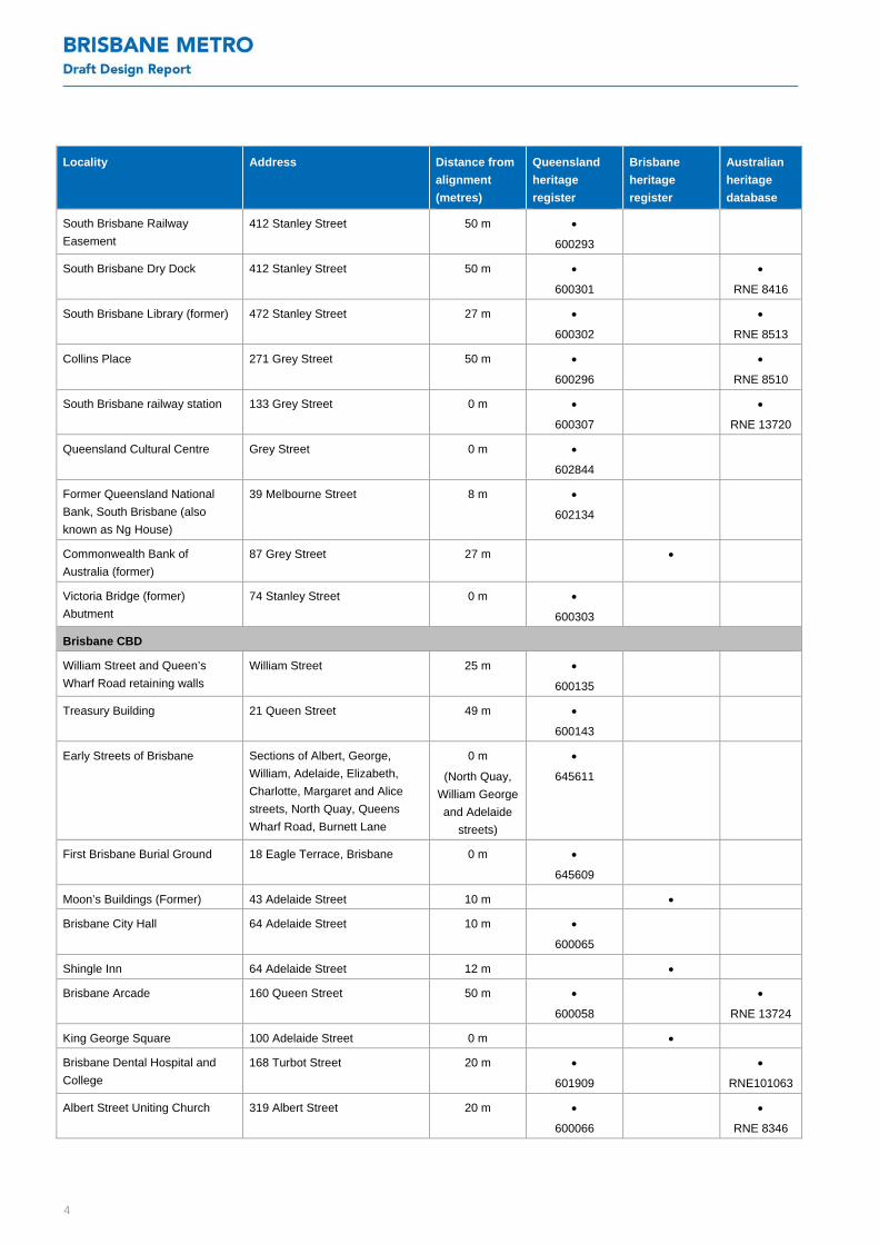
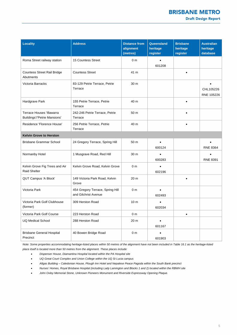
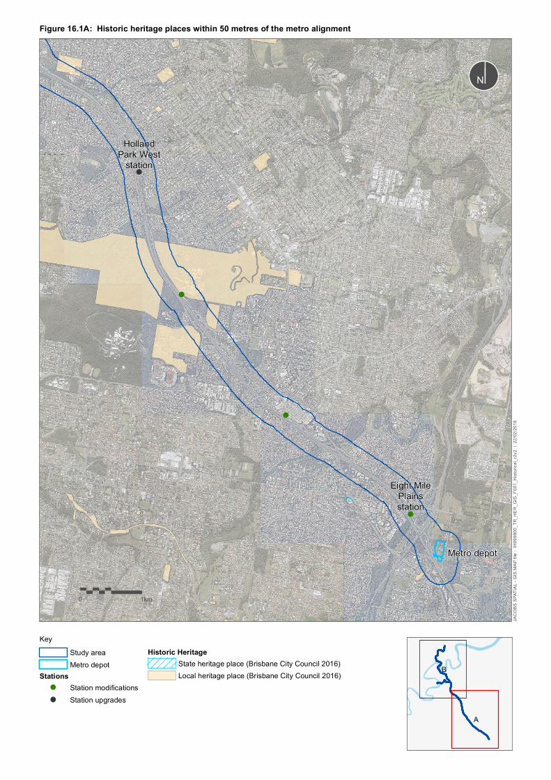
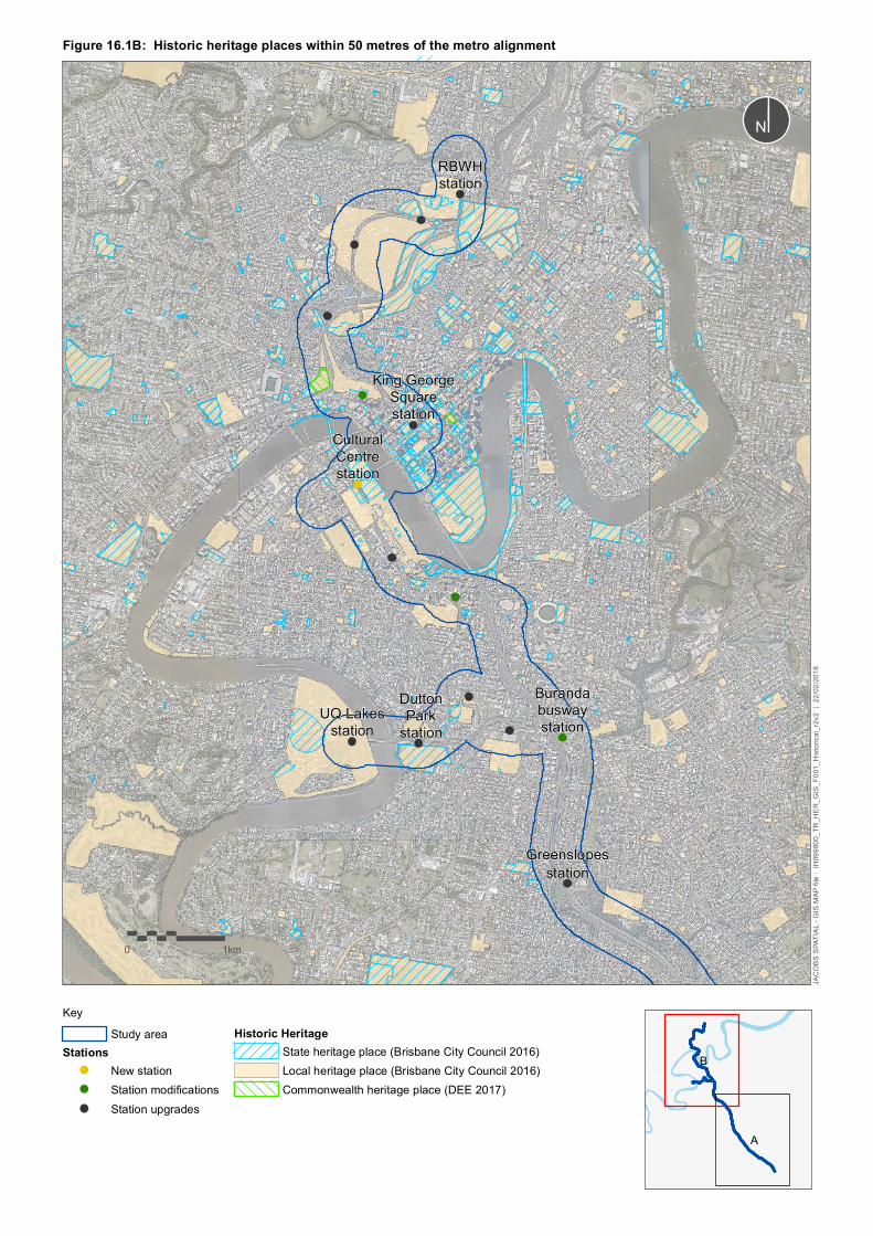
There are 49 historical heritage places within 50 metres of the alignment or proposed construction worksites and laydown areas. These are listed in Table 16.1 and shown Figure 16.1 and include:
one place listed on the Commonwealth heritage list
30 places listed on the Queensland heritage register
18 local heritage places listed on the Brisbane heritage register.
South Brisbane railway station and Roma Street railway station are also listed on Queensland Rail’s internal Queensland Rail heritage register.
A number of places at South Brisbane and within the CBD listed on the Queensland heritage register and one on the Brisbane heritage register are located immediately adjacent to new infrastructure or require works within their boundaries. These are discussed in further detail in section 16.3.3 and section 16.3.4.
Table 16.1: Historic heritage places within 50 metres of the alignment
Locality Address Distance from
alignment
(metres)
Queensland
heritage
register
Brisbane
heritage
register
Australian
heritage
database
Mt Gravatt to Greenslopes
Toohey Forest Park 600 Toohey Road, Salisbury 0 m
Woolloongabba to St Lucia
Norman Hotel 102 Ipswich Road 40 m (from
building)
602539
Morrison Hotel 640 Stanley Street 43 m
Shop 582 Stanley Street 45 m
Magee’s Drapery Emporium 588 Stanley Street 45 m
Shops 596-614A Stanley Street 45 m
Boggo Road Gaol: No 2 Division
and Remnant No 1 Division
150 Annerley Road 0 m
601033
Gair Park 181 Annerley Road 5 m
602429
South Brisbane Cemetery 21 Fairfield Road 6 m
602406
Dutton Park 359 Gladstone Road 24 m
South Brisbane
Westpac Building – Bank of New
South Wales (former)
496 Stanley Street 8 m
South Brisbane Memorial Park 459 Stanley Street 26 m
South Brisbane Municipal
Chambers (former)
263 Vulture Street 11 m
600306
RNE
Somerville House 253 Vulture Street 11 m
600305
RNE
11 Centre for the Government of Queensland (2015) Eight Mile Plains, Queensland Places, accessed June 2017 at
http://queenslandplaces.com.au/eight-mile-plains
4
Locality Address Distance from
alignment
(metres)
Queensland
heritage
register
Brisbane
heritage
register
Australian
heritage
database
South Brisbane Railway
Easement
412 Stanley Street 50 m
600293
South Brisbane Dry Dock 412 Stanley Street 50 m
600301
RNE 8416
South Brisbane Library (former) 472 Stanley Street 27 m
600302
RNE 8513
Collins Place 271 Grey Street 50 m
600296
RNE 8510
South Brisbane railway station 133 Grey Street 0 m
600307
RNE 13720
Queensland Cultural Centre Grey Street 0 m
602844
Former Queensland National
Bank, South Brisbane (also
known as Ng House)
39 Melbourne Street 8 m
602134
Commonwealth Bank of
Australia (former)
87 Grey Street 27 m
Victoria Bridge (former)
Abutment
74 Stanley Street 0 m
600303
Brisbane CBD
William Street and Queen’s
Wharf Road retaining walls
William Street 25 m
600135
Treasury Building 21 Queen Street 49 m
600143
Early Streets of Brisbane Sections of Albert, George,
William, Adelaide, Elizabeth,
Charlotte, Margaret and Alice
streets, North Quay, Queens
Wharf Road, Burnett Lane
0 m
(North Quay,
William George
and Adelaide
streets)
645611
First Brisbane Burial Ground 18 Eagle Terrace, Brisbane 0 m
645609
Moon’s Buildings (Former) 43 Adelaide Street 10 m
Brisbane City Hall 64 Adelaide Street 10 m
600065
Shingle Inn 64 Adelaide Street 12 m
Brisbane Arcade 160 Queen Street 50 m
600058
RNE 13724
King George Square 100 Adelaide Street 0 m
Brisbane Dental Hospital and
College
168 Turbot Street 20 m
601909
RNE101063
Albert Street Uniting Church 319 Albert Street 20 m
600066
RNE 8346
5
Locality Address Distance from
alignment
(metres)
Queensland
heritage
register
Brisbane
heritage
register
Australian
heritage
database
Roma Street railway station 15 Countess Street 0 m
601208
Countess Street Rail Bridge
Abutments
Countess Street 41 m
Victoria Barracks 83-129 Petrie Terrace, Petrie
Terrace
30 m
CHL105226
RNE 105226
Hardgrave Park 155 Petrie Terrace, Petrie
Terrace
40 m
Terrace Houses 'Illawarra
Buildings’/‘Petrie Mansions'
242-246 Petrie Terrace, Petrie
Terrace
50 m
Residence 'Florence House' 256 Petrie Terrace, Petrie
Terrace
40 m
Kelvin Grove to Herston
Brisbane Grammar School 24 Gregory Terrace, Spring Hill 50 m
600124
RNE 8364
Normanby Hotel 1 Musgrave Road, Red Hill 30 m
600283
RNE 8391
Kelvin Grove Fig Trees and Air
Raid Shelter
Kelvin Grove Road, Kelvin Grove 0 m
602196
QUT Campus 'A Block' 149 Victoria Park Road, Kelvin
Grove
20 m
Victoria Park 454 Gregory Terrace, Spring Hill
and Gilchrist Avenue
0 m
602493
Victoria Park Golf Clubhouse
(former)
309 Herston Road 10 m
602034
Victoria Park Golf Course 223 Herston Road 0 m
UQ Medical School 288 Herston Road 20 m
601167
Brisbane General Hospital
Precinct
40 Bowen Bridge Road 0 m
601903
Note: Some properties accommodating heritage-listed places within 50 metres of the alignment have not been included in Table 16.1 as the heritage-listed
place itself is located more than 50 metres from the alignment. These places include:
Dispenser House, Diamantina Hospital located within the PA Hospital site
UQ Great Court Complex and Union College within the UQ St Lucia campus
Allgas Building – Caledonian House, Plough Inn Hotel and Nepalese Peace Pagoda within the South Bank precinct
Nurses’ Homes, Royal Brisbane Hospital (including Lady Lamington and Blocks 1 and 2) located within the RBWH site
John Oxley Memorial Stone, Unknown Pioneers Monument and Riverside Expressway Opening Plaque.
Metro depot
Eight MilePlainsstation
HollandPark West
station
0 1km
JACO
BS S
PATIA
L - G
IS M
AP fil
e : IH
0998
00_T
R_HE
R_GI
S_F0
01_H
istori
cal_r
2v2
| 22/0
2/201
8
KeyStudy areaMetro depot
StationsStation modificationsStation upgrades
Historic HeritageState heritage place (Brisbane City Council 2016)Local heritage place (Brisbane City Council 2016)
¬«³³N
A
B
Figure 16.1A: Historic heritage places within 50 metres of the metro alignment
CulturalCentrestation
King GeorgeSquarestation
BurandabuswaystationUQ Lakes
station
Greenslopesstation
RBWHstation
DuttonPark
station
0 1km
JACO
BS S
PATIA
L - G
IS M
AP fil
e : IH
0998
00_T
R_HE
R_GI
S_F0
01_H
istori
cal_r
2v2
| 22/0
2/201
8
KeyStudy area
StationsNew stationStation modificationsStation upgrades
Historic HeritageState heritage place (Brisbane City Council 2016)Local heritage place (Brisbane City Council 2016)Commonwealth heritage place (DEE 2017)
¬«³³N
A
B
Figure 16.1B: Historic heritage places within 50 metres of the metro alignment
8
Areas of historical archaeological potential
Several areas of historical archaeological potential are located within the study area that are not specifically registered as archaeological places, however are subject to the provisions of the QH Act.
The proposed depot site at Rochedale has been subject to limited disturbance from development. There is potential for historical archaeological remains to be present related to the early settlement and agricultural use of the area, due to its proximity to the main early thoroughfare of Logan Road and the initial settlement of Eight Mile Plains.
Open areas near the alignment at South Brisbane may also have historical archaeological potential, given the early nature of non-Indigenous settlement of South Brisbane, and the limited deep development in these locations. South Brisbane’s earliest underground drains, including potentially convict-built structures, may still be present in the vicinity of the Queensland Cultural Centre and Melbourne Street. Brisbane’s former tramway system also operated along Melbourne Street and there is some potential for subsurface remains to be present related to this.
A section of open space at the corner of Peel and Grey Streets (Alexander Smith Place) has been identified as a proposed construction laydown area. This site is noted as the location from which one of Brisbane’s first free immigrants operated as a drayman between 1857 and 1884, helping to turn the abandoned penal settlement into a prosperous township (Council sign at site). The site has been an open space since at least 1947, and may potentially contain archaeological remains related to the early development of South Brisbane.
16.3.3 South Brisbane
South Brisbane railway station
South Brisbane railway station (QHR 6003007) was constructed in 1891 as the terminus for the new rail extension from Boggo Junction (now Dutton Park). The station was expanded to six platforms between 1914 and 1918. In 1930, a separate interstate platform, station, goods shed and shunting yards were constructed, although these were all demolished in 1986 for the Expo 88 redevelopment.
Since 1986, two of the circa 1918 island platforms have been removed and the station reverted to its original two platforms. These are level with the upper floor of the main building. The awning to the No 1 platform retains a tank roof on a steel frame, with cast-iron columns and brackets and a decorative timber frieze (1891). The No 2 platform has a cantilevered butterfly roof, which is supported by lattice iron girders (c1918). Both platforms include a number of early cast-iron framed seats, many of which were collected from other metropolitan stations for the Expo 88 refurbishment. The main building remains substantially intact, despite alteration. The turntable, two island platforms and the front park and garden have been removed.
The South Brisbane railway station is historically significant as a ‘reflection of the importance of South Brisbane as a commercial centre in the late 19th and early 20th centuries, and as a major terminal in the south-east Queensland regional rail network until 1986. It is a substantially intact masonry railway station complete with early platform furniture, one of only three erected in Brisbane by 1901’12.
A conservation management plan was prepared for South Brisbane railway station in 200413. The plan provides details of the history, significance, significant elements and conservation measures to manage impacts to the heritage significance of the place. Key elements of the railway station relevant to Brisbane Metro and their significance are presented in Table 16.2. Conservation recommendations relevant to the Brisbane Metro are presented in Table 16.3.
12 QHR (2017a) South Brisbane Railway Station, accessed March 2017 at https://environment.ehp.qld.gov.au/heritage-register/detail/?id=600307 13 Buchanan Architects (2004)

9
Table 16.2: Significance of key elements of South Brisbane railway station14
Element Significance
Remaining platform shades, including the bow chord shade to platform 1 and the butterfly shade to island
platforms 2 and 3, including cast iron columns
Primary significance
Subway entrances, including steps and balustrades from island platform 2 and 3 Primary significance
Old Queensland Rail platform seats, relocated from elsewhere for Expo 88 Some significance
Concrete platform copings Some significance
Timber picket fencing to top of retaining wall (platform 1) Some significance
Forecourt paving, including concrete unit pavers and bitumen No significance
Hoardings and modern development infrastructure within open space between station and Melbourne Street
intersection (125 Grey Street)
No significance
Table 16.3: Relevant conservation recommendations, South Brisbane railway station15
Number Recommendation
Recommendation 8:
Evidence of use as a
railway station
The surviving station building is demonstrative of the importance of the place, being a substantial two storeyed
masonry railway station with characteristic platform shades. Its remaining elements of cultural significance
should be carefully conserved.
Recommendation 9: New
buildings on the site
Any new buildings on the site should acknowledge the primary importance of the historic station building and its
platforms. They should not seek to replicate the traditional forms and details of the station building or its
platform shades, and should preferably be in an architectural language ‘of their own time’. They should also be
sited in such a way as to retain space around the historic building.
The parcel of land that includes the railway station and rail corridor also contains a substantial portion of open
site at the intersection of Melbourne and Grey streets, and to the south of the station along Grey Street. New
development [in these areas] should respect the nature of the urban context of which the station building is a
part. It should also be designed in such a way that pedestrians at the street level of Grey Street retain a view
towards the station. The station building was originally designed to provide a strong architectural statement
towards Grey Street, and there should be no new development that compromises the symmetry of that
statement.
Recommendation 13: The
urban context
South Brisbane railway station provides an interesting contrast, and a historical counterpoint within a radically
changed urban environment. The original streetscape has been lost, and an opportunity now remains to allow
the station to strengthen its relationship and contribution to the public realm of Grey Street and South Bank. At
the same time, the design challenge must accept the heritage significance of the station as part of the new
environment, and it should remain the centrepiece of any new buildings around it.
Former Queensland National Bank, South Brisbane Branch
The former Queensland National Bank (QHR 602134) (now known as Ng House) was constructed in 1929 and is evidence of the optimism about Queensland’s economy in the 1920s. This place is significant for its historical, aesthetic, social and associative significance and its rarity. Along with the adjacent former Commonwealth Bank Building, the building contributes to the Grey Street streetscape and is a prominent landmark in the South Brisbane area. It is also a rare surviving remnant of the former commercial scale of the South Brisbane area, which has been substantially altered due to development16.
Queensland Cultural Centre
The Queensland Cultural Centre (QHR 602844) was entered on the Queensland heritage register in 2015. It is important for its historical, architectural, aesthetic, social and associative significance, and its principal characteristics and rarity. It “combines an art gallery, museum, performing arts complex and associated ancillary
14 Buchanan Architects (2004) p34-36 15 Buchanan Architects (2004) p40-42 16 QHR (2017b) Queensland National Bank (former), South Brisbane Branch, accessed May 2017 at https://environment.ehp.qld.gov.au/heritage-
register/detail/?id=602134
10
facilities on the one site, interconnected by outdoor plazas and boulevards and is notable for its functionality, planning and finishes. The open space – between the river and cultural facilities, the forecourt and plazas, contribute to the landmark quality of the complex, facilitating views to and from the river, the Victoria Bridge, the central business district and the surrounding streets in South Brisbane”. The complex’s significant aspects include the integration between the buildings and their setting, the connection with the river, its monumental scale, prominent siting and distinctive architectural qualities17.
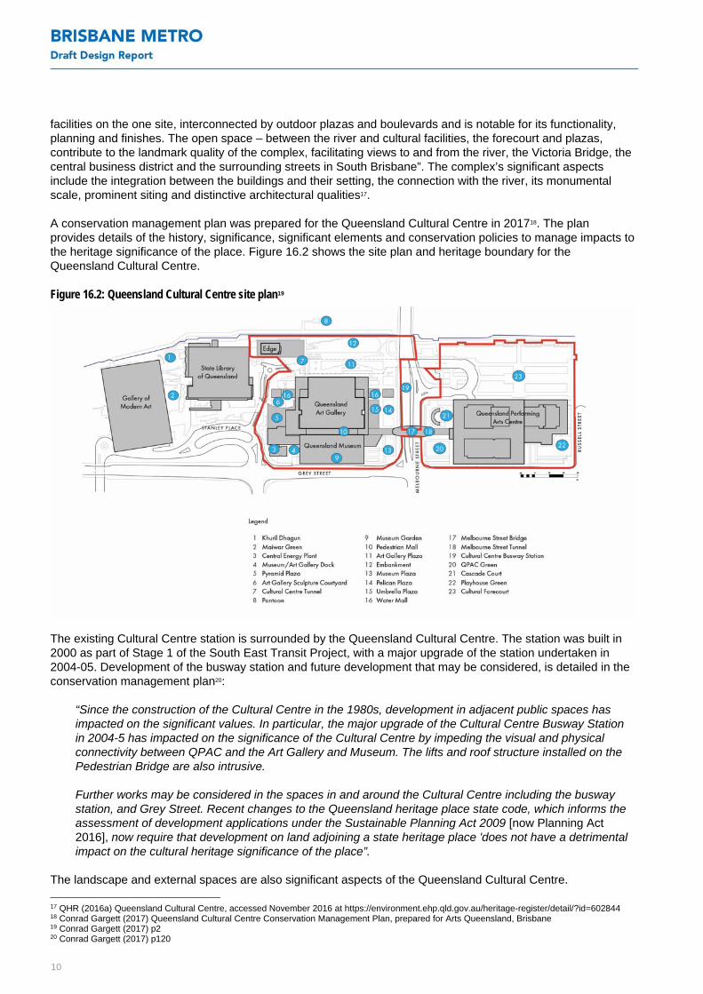
A conservation management plan was prepared for the Queensland Cultural Centre in 201718. The plan provides details of the history, significance, significant elements and conservation policies to manage impacts to the heritage significance of the place. Figure 16.2 shows the site plan and heritage boundary for the Queensland Cultural Centre.
Figure 16.2: Queensland Cultural Centre site plan19
The existing Cultural Centre station is surrounded by the Queensland Cultural Centre. The station was built in 2000 as part of Stage 1 of the South East Transit Project, with a major upgrade of the station undertaken in 2004-05. Development of the busway station and future development that may be considered, is detailed in the conservation management plan20:
“Since the construction of the Cultural Centre in the 1980s, development in adjacent public spaces has impacted on the significant values. In particular, the major upgrade of the Cultural Centre Busway Station in 2004-5 has impacted on the significance of the Cultural Centre by impeding the visual and physical connectivity between QPAC and the Art Gallery and Museum. The lifts and roof structure installed on the Pedestrian Bridge are also intrusive.
Further works may be considered in the spaces in and around the Cultural Centre including the busway station, and Grey Street. Recent changes to the Queensland heritage place state code, which informs the assessment of development applications under the Sustainable Planning Act 2009 [now Planning Act 2016], now require that development on land adjoining a state heritage place 'does not have a detrimental impact on the cultural heritage significance of the place”.
The landscape and external spaces are also significant aspects of the Queensland Cultural Centre.
17 QHR (2016a) Queensland Cultural Centre, accessed November 2016 at https://environment.ehp.qld.gov.au/heritage-register/detail/?id=602844 18 Conrad Gargett (2017) Queensland Cultural Centre Conservation Management Plan, prepared for Arts Queensland, Brisbane 19 Conrad Gargett (2017) p2 20 Conrad Gargett (2017) p120

11
“The four courtyards fronting Melbourne Street are a strong urban planning design concept, providing formal pedestrian entry points to QPAC, QM [Queensland Museum] and QAG [Queensland Art Gallery]. They also are an integral element of how the centre forms a 'gateway' to the Brisbane CBD when approached from Melbourne Street”21.
In conjunction with these courtyards, the pedestrian bridge over Melbourne Street also contributes to the symbolic gateway to the city centre. The lifts and roof structure on the pedestrian bridge are identified as intrusive elements within the conservation management plan22.
In relation to QPAC Green, the conservation management plan states that:
“The QPAC Green was initially an open turfed space with Tipuana trees on edges fronting Grey and Melbourne Streets. It was intended as a shady haven with large trees and lawns for more leisurely activities. It is a critical entry point to QPAC, being located on the corner of Melbourne and Grey Streets. As such it has become a highly activated space as pedestrian traffic in South Brisbane has increased. Furthermore, increasing demand for food and beverage outlets and informal performance spaces has also contributed to the activation of the space. To respond to these changes, various alterations have been made to the QPAC Green, most as temporary or interim solutions. A more considered and long-term solution needs to be addressed”23.
The Cultural Forecourt between the Brisbane River and QPAC (owned by South Bank Corporation and managed by Council) is also a key external space24. While it was constructed after Expo 88, the original Queensland Cultural Centre master plan envisaged this space as an external open space, although it was compromised by the reorientation of Stanley Street and as such was truncated by roadways. The landscape design and plant selections made within the Cultural Forecourt took cues from the Queensland Cultural Centre design. Its inclusion within the heritage boundary aligns with the perimeter of the sub-grade car park and enhances the curtilage and sightlines to QPAC from the river and city.
The key elements of the Queensland Cultural Centre relevant to Brisbane Metro are presented in Table 16.4, along with their level of significance as identified in the conservation management plan. Relevant conservation policies identified in the conservation management plan are presented in Table 16.5.
Table 16.4: Elements of the Queensland Cultural Centre relevant to Brisbane Metro25
Element Significance
Views to Cultural Centre from north bank including Southeast Freeway, Melbourne Street and Grey Street.
Unencumbered exposure to the Brisbane River, permitting views to the Cultural Centre from the city
Significant
Internal views from within original openings to external spaces and cityscape Significant
Elevated Pedestrian Mall as unifying circulation pathway
As the major pedestrian linkage between QPAC, Queensland Museum and Queensland Art Gallery this
element is a key organisational device for the complex.
Significant
Separation of pedestrian and vehicular traffic throughout the site Significant
Original material palette including concrete, glazing, bronze elements, and stone (travertine, Mt Coot-tha
bluestone)
Significant
Setting—relationship with Brisbane River and Taylor Range Significant
Principal external circulation routes including Pedestrian Mall (including Cultural Centre pedestrian bridge),
walkways adjacent to Art Gallery, tunnels, tunnel from towpath to Stanley Street adjacent to The Edge
Significant
Cultural Centre busway station and lifts (19) Intrusive/diminishes
significance of the place
Cultural Centre tunnel Significant
21 Conrad Gargett (2017) p122 22 Conrad Gargett (2017) p120, p124 23 Conrad Gargett (2017) p123 24 Conrad Gargett (2017) 25 Conrad Gargett (2017) p109-115

12
Element Significance
Melbourne Street tunnel Significant
Roof structure ('surfboard') over Melbourne Street pedestrian bridge (18) Intrusive/diminishes
significance of the place
Open space – Cultural forecourt
The Cultural Forecourt is significant primarily as an open space providing views to and from QPAC and not
for its landscape design.
Significant
Open space of QPAC Green Significant
QPAC Green components, including Grey Street entrance to QPAC Green, temporary stage, entry structure
from Grey Street and roof canopy, and cafe fit-out
Not significant
Lightweight timber fencing bounding QPAC Green Intrusive/diminishes
significance of the place
Ramp adjacent to Victoria Bridge Not significant
Table 16.5: Queensland Cultural Centre conservation policies relevant to Brisbane Metro26
Policy number Policy
Policy 2: Design
framework
All alterations, additions, repairs and maintenance on the Cultural Centre should respect and acknowledge
the framework of the original Gibson design:
simple palette of materials
geometry and structural grid
consistent colour
fusion of the landscape and architecture
horizontality and cubic form
hierarchy and visual relationship of spaces
use of natural light
Policy 6: Long-term
planning
In considering any major alterations and additions to the Cultural Centre, give careful consideration to the
long-term implications of change. Avoid solutions of inferior quality, that are ad hoc or that are of a limited
life span
Policy 8: Setting Conserve the significant relationships, including both visual and physical, that the Cultural Centre has with
its setting. These include:
The Brisbane River
Melbourne Street
Grey Street
Mount Coot-tha and Taylor Range
Policy 9: Development in
adjacent public spaces
Proponents of any works planned in public spaces immediately adjoining the Cultural Centre should ensure
that the development does not have a detrimental impact on the cultural heritage significance of the
Cultural Centre in compliance with the Planning Act 2016
Policy 14: Non-significant
elements
Non-significant elements may be removed or altered without diminishing the cultural heritage significance of
the place
Policy 15: Intrusive
elements
Consider the feasibility of removing intrusive elements when the opportunity arises in later works
Policy 17: Landscape
approach
Maintain the grade separation between vehicular and pedestrian circulation. Ensure the key landscape
principles are conserved in ongoing maintenance works and utilised in future works
Conserve significant views and vistas associated with the landscape by appropriate management of
plantings
Conserve built elements such as paving, steps, lighting, wall and planter boxes in a consistent form, using
materials that reflect the original design intent
26 Conrad Gargett (2017) p120-123

13
Policy number Policy
Policy 19: New landscape
elements
Any new landscape development should not conflict with or diminish the overall significance of the
landscape design, and its interrelated role with the architecture
Policy 21: QPAC Green Retain as an open space. The space could be developed with new facilities and amenities that allow its
continued use as an informal performance space as well as food and beverage services provided that the
original architectural and landscape design intent is respected
Consider replacing the temporary stage, fencing and turf with a high-quality, long-term solution
Policy 34: External
lighting and projected
lighting
External and projected lighting should respect the design qualities of the Cultural Centre
Policy 36: Cultural
Forecourt – open space
The Cultural Forecourt should be retained principally as an open space. The current use as an event space
with temporary structures is appropriate
Policy 37: Cultural
Forecourt – management
of vegetation
Ensure that vegetation in the Cultural Forecourt is maintained to provide shade and pedestrian amenity
Ensure existing trees within the Cultural Forecourt are managed to maintain tree health, and a balance
between canopy coverage, pedestrian amenity and significant views
Policy 38: Cultural
Forecourt – new
structures
New structures within the Cultural Forecourt should be consistent with a site-wide approach to new external
works and should not substantially obscure existing sightlines to Queensland Performing Arts Centre from
the river and city beyond
Policy 89: Expert advice Specialist advice must be sought from an expert panel for all proposals for alterations or additions proposed
to the Cultural Centre that would impact on the cultural heritage significance and the original design
principles, specifically as they relate to the architectural and landscape attributes
Policy 93: Records Keep and archive all relevant and important documents relating to the construction and maintenance of the
Cultural Centre
Former Victoria Bridge abutments
Victoria Bridge connects South Brisbane to the CBD at North Quay. The former Victoria Bridge Abutments (QHR 600300) are located immediately downstream of the existing Victoria Bridge and are the only remaining elements of the fourth bridge built at this location. The first bridge at this location was constructed from timber in 1865, but closed two years later due to marine borers. The second bridge was not completed until 1874, and was destroyed by flooding in 1893. A third, temporary bridge, was erected in 1893, but was destroyed by flooding in 1896. The fourth bridge was constructed in 1896-97 with impressive stone arches flanking the approaches. It remained the only permanent river crossing between the north and south banks of the river within Brisbane until the 1930s. This bridge was demolished in 1969 and replaced with the current Victoria Bridge. The former Victoria Bridge abutments were left in ruinous state following the demolition of the remainder of the bridge, with restoration work occurring for Expo 88. The southern abutment comprises a Brisbane Tuff podium, with the pedestrian footway arch, a section of roadway and tramways tracks atop. The northern abutment comprises the Brisbane Tuff podium structure only. The abutments are listed for their historical significance, potential to yield information, aesthetic significance, and social significance27.
Other Victoria Bridge components
The current Victoria Bridge was constructed in 1969 and is not registered on any statutory heritage register. Side scan sonar in the Brisbane River has indicated that there are archaeological remains of the first and second Victoria Bridges within the Brisbane River downstream of the current bridge28.
16.3.4 Brisbane CBD
William Street and Queens Wharf Road retaining walls
The William Street and Queens Wharf Road retaining walls (QHR 600135) (also known as the North Quay porphyry wall), were built in 1889 (southern side of William Street) and 1936 (southern side of Queens Wharf 27 QHR (2016b) Former Victoria Bridge Abutments, accessed October 2016 at https://environment.ehp.qld.gov.au/heritage-register/detail/?id=600303 28 Urbis (2017) Queen's Wharf Brisbane Archaeological Management Plan, report prepared for Destination Consortium Brisbane
14
Road). Constructed of Brisbane Tuff with sandstone coping and decorative metal railings, the walls extend approximately 70 metres between Queen and Elizabeth streets. They include several original features and later additions including a lamp base, former closet recess, stairwell, men’s toilets and a World War II air raid shelter. The William Street and Queens Wharf Road retaining walls have historical significance, potential to yield information, representativeness, and its aesthetic significance29.
Early Streets of Brisbane
The Early Streets of Brisbane (QHR 645611) include sections of Albert Street, George Street, William Street, North Quay, Queens Wharf Road, Adelaide Street, Burnett Lane, Elizabeth Street, Charlotte Street, Margaret Street and Alice Street in the CBD. These streets have the potential to contain archaeological artefacts that are an important source of information about Queensland’s history, including the establishment, evolution and pattern of settlement of early Brisbane as a penal colony30. Sections of the Early Streets of Brisbane along the alignment are the road reserves and footpaths at:
North Quay, between Adelaide and Queen streets, including the Adelaide Street intersection
a small area at the northwest end of Queens Wharf Road and William Street at the intersection with North Quay, Victoria Bridge and Queen Street (including Lot 209 SP289465)
Adelaide Street, between George and Albert Streets, excluding the Albert Street intersection.
Stone kerbing
While not listed on any statutory heritage register, heritage stone kerbing is situated within the Early Streets of Brisbane, particularly along North Quay and Adelaide Street, and may occur elsewhere along the alignment. Heritage stone kerbing is protected by the Brisbane City Plan Infrastructure Design Planning Scheme Policy (SC6.16, 3.8 Heritage kerb). The heritage kerbing includes kerbs, crossovers, channel stones and margin stones or other stone features made from either Brisbane Tuff or granite. It provides important evidence of Brisbane’s early road development and changing road building and drainage methods. It also provides streetscape character and aesthetic settings of significant buildings and structures31.
Brisbane City Hall
The site for the City Hall (QHR 600065) was chosen in the early 20th century, mainly due to it being Council land and that minimal resumptions were required. An original design in 1909 was not constructed, and a second design was developed in 1919, with construction commencing to modified plans in 1924. While the building commenced use in 1927, the building was not completed until 1930.
King George Square was opened in 1975 after Albert Street was closed in front of City Hall in 1966. City Hall was renovated and partly converted into a community centre in the mid-1970s32. Substantial renovation works were undertaken between 2010 and 2013, including excavation at basement level, which revealed a cobblestone drain and paving dating to the late 1880s, when the site was converted from swamp land into Council yards. The archaeological features were revealed approximately three metres below the main auditorium floor level33.
Moon’s Buildings
Moon’s Buildings is listed on the Brisbane heritage register. Constructed in 1900 for the general merchant Alfred Moon as a shop and office building, its construction marked the expansion of retail businesses to Adelaide Street. Multiple notable Queensland businesses occupied the building throughout the 20th century including
29 QHR (2017c) William Street and Queens Wharf Road retaining walls, accessed July 2017 at https://environment.ehp.qld.gov.au/heritage-
register/detail/?id=600135 30 QHR (2016c) Early Streets of Brisbane, accessed September 2016 at https://environment.ehp.qld.gov.au/heritageregister/detail/?id=645611 31 Brisbane City Council (2013) Centres Detail Design Manual (superseded) 32 QHR (2017d) Brisbane City Hall, accessed July 2017 at https://environment.ehp.qld.gov.au/heritage-register/detail/?id=600065 33 Brisbane City Council (2015) City Hall Archaeological Discoveries, accessed July 2017 at https://www.brisbane.qld.gov.au/facilities-
recreation/parks-venues/brisbane-city-hall/city-hall-history-heritage/city-hall-archaeological-discoveries

15
Brisbane’s first commercial radio station 4BC, The Sun newspaper, and Cannon and Cripps undertakers. It was also the site of Queensland’s first Chandlers electrical store34.
Roma Street railway station
Roma Street was largely undeveloped until the construction of the Brisbane rail terminus (present day Roma Street railway station (QHR 601628)) in 1875 for use on the Brisbane end of the south-western railway line from Toowoomba35. The station and surrounding rail yards have been dramatically altered over the years. The most recent and significant change to the railway station occurred in the 1980s with construction of the Brisbane Transit Centre, incorporating the Travelodge Hotel (now Hotel Jen). This development led to the demolition of the 1940s railway station building. In the 1990s, additional re-arrangement and extension of the platforms to the north and south of the early station building was carried out.
The Roma Street railway station is listed for its historical significance, representativeness, aesthetic significance and social significance. The Queensland heritage register listing includes the substantial 1873-1875 rendered masonry building, situated between the new Roma Street station behind the modern tower on Roma Street and the platform structures to the rear36.
The Inner Northern Busway, opened in 2008, runs through the Roma Street railway station, with the Roma Street busway station located adjacent to and part of the Roma Street railway station.
Victoria Barracks
Victoria Barracks is located between Petrie Terrace and Countess Street, east of the Roma Street railway yard. The Barracks is listed on the Commonwealth heritage list and is historically important for its long associated with Queensland and Australia’s defence. Works for Brisbane Metro in this section of the alignment will involve new line marking for a metro layover and turnaround facility and will not involve any new construction works. As such, no impacts on the heritage values of Victoria Barracks are anticipated from Brisbane Metro.
First Brisbane Burial Ground
The First Brisbane Burial Ground (QHR 645609) located at Skew Street is the first European burial ground in Queensland. The cemetery was established in 1825 with the establishment of the Moreton Bay Penal Settlement in Brisbane. It operated until the North Brisbane Burial Ground, situated at the current location of Lang Park/Suncorp Stadium, opened in 1843. At least 220 convicts, soldiers, women and children are known to have been interred in the First Brisbane Burial Ground, accounting for most of the people who died in the Moreton Bay Penal Settlement between 1825 and 1843. The archaeological integrity and potential for site preservation of the First Brisbane Burial Ground is high37.
Although there is no surface evidence of the burial ground, the documented history and an understanding of the previous usage of the area, particularly a lack of major development, indicates potential for both human remains and archaeological artefacts to exist within the place. Archaeological investigations on the site have the potential to answer important research questions about Queensland's history relating to the importation of materials; decay processes; colonial burial practices; gender, class and denominational differences; differential treatment of officers, soldiers, convicts and civilians; and health, nutrition and causes of death in the early colony38. While the site is a public park, it has previously been used, as a temporary construction laydown area for various projects.
34 Brisbane City Council (2016a) City Plan Heritage Register, Moon’s Buildings (Former), accessed August 2017 at
https://heritage.brisbane.qld.gov.au/heritage_register/placeDetail.do?action=read&placeId=2016&fullDetail=true&navParam=startBasic 35 TMR (2014) 36 QHR (2016d) Roma Street Railway Station, accessed October 2016 at https://environment.ehp.qld.gov.au/heritage-register/detail/?id=601208 37 QHR (2017e) First Brisbane Burial Ground, accessed August 2017 at https://environment.ehp.qld.gov.au/heritage-register/detail/?id=645609 38 QHR (2017e)
16
16.4 Potential impacts
This section assesses potential impacts on heritage values in the study area from the siting or construction of Brisbane Metro infrastructure. It describes general impacts (refer to section 16.4.1) as well as impacts on specific heritage places (refer to section 16.4.2).
Potential risks for historical heritage values generally relate to the siting or construction of new or modified infrastructure and impacts are not expected to occur where Brisbane Metro uses existing busway infrastructure. Impacts on heritage values are also not expected from the ongoing operation of Brisbane Metro.
16.4.1 General construction impacts
Siting or construction of infrastructure
The siting or construction of Brisbane Metro infrastructure is expected to directly impact the following heritage places.
South Brisbane railway station, Queensland Cultural Centre (including Cultural Centre pedestrian tunnel and pedestrian bridge, Cultural Centre tunnel and QPAC Green) due to the new underground Cultural Centre station, including the underpass of the existing railway corridor, station box and transition structure to Victoria Bridge
Early Streets of Brisbane and stone kerbing, and possibly Moon’s Buildings from construction of the Adelaide Street tunnel
First Brisbane Burial Ground, and subsurface historical archaeological deposits and features due to the location of construction laydown areas.
The siting or construction of project infrastructure also has potential to directly impact subsurface historical archaeological deposits and features associated with the early development of Brisbane.
Indirect physical impacts
Potential impacts on heritage places near Brisbane Metro infrastructure, construction works and construction laydown areas could result from dust deposition from construction activities resulting in possible corrosion of fabric, accidental damage from physical contact by construction materials or machinery/vehicles, and impacts which alter the setting of heritage places or streetscapes.
Further discussion of potential dust impacts is provided in Chapter 11. Environmental management measures will be implemented to minimise potential construction air quality impacts.
Settlement
Differential settlement from excavation has potential to impact on heritage places. Potential impacts from settlement at heritage places closest to excavation works are generally expected to be negligible, although the proposed jacked box construction of the underpass at South Brisbane railway station has potential to result in temporary settlement issues for the platforms.
Prior to construction, building condition surveys will be conducted for heritage places identified as potentially affected by settlement. Although not expected, any damage resulting from excavation will be repaired by a suitably qualified professional, in accordance with the requirements of the Burra Charter and any specific approvals conditions from the relevant heritage authority. This will assist in managing any potential settlement impacts on heritage places near the alignment.
17
Visual impacts
Surface infrastructure associated with Brisbane Metro may potentially have impacts on heritage places, either adversely or positively, by:
changing views to and from heritage places (e.g. new Cultural Centre station entrance, relocation of lifts on the Cultural Centre pedestrian bridge, transition structure)
introducing new built elements that are visually inconsistent with the nature and character of the surrounding area
removing intrusive built elements (e.g. existing Cultural Centre station, including the station’s central lift and stairwell connecting to the Cultural Centre pedestrian bridge).
Vibration
Vibration from construction activities has potential to result in physical damage to heritage structures. Vibration modelling undertaken for Brisbane Metro indicates that vibration levels from construction works at heritage listed properties near the alignment are generally predicted to be below the vibration goal relating to possible cosmetic damage and are not expected to cause damage to these buildings. However, some construction activities for the new underground Cultural Centre station have potential to exceed the stringent cosmetic damage goal at South Brisbane railway station and the former Queensland National Bank building (Ng House). Further discussion about potential vibration impacts on heritage buildings and proposed management measures is provided in section 16.4.2 and in Chapter 10.
16.4.2 Potential impacts on specific heritage places
As indicated in section 16.3.2, a number of places listed on the Queensland heritage register and Brisbane heritage register are within or near the alignment or construction worksites and laydown areas and may be subject to potential impacts from the siting or construction of Brisbane Metro. The following provides a more detailed discussion of potential impacts on these places.
South Brisbane railway station
The existing railway corridor and parts of the South Brisbane railway station will be subject to direct impacts from the construction of the underpass of the railway corridor connecting the existing South East Busway to the new underground Cultural Centre station.
Construction of the underpass by jacked box construction method would require the partial demolition of the gravity retaining wall, No 1 platform, including the concrete platform coping, and the temporary removal of heritage features such as timber picket fence at the top of the gravity retaining wall of No 1 platform, and the old Queensland Rail platform seats. Following construction, these features would be reinstated.
Measures will be implemented to minimise impacts on the heritage significance of the railway station during construction. These include:
detailed recording of the current condition of the concrete coping on No 1 platform, timber picket fence on No 1 platform/retaining wall, platform furniture, any other key heritage components to be removed, and the main station building
careful and planned removal and storage of the platform furniture, platform copings, and timber picket fence, to enable accurate reinstatement of these elements following construction
reconstruction of platform with new materials, but reinstatement of existing concrete coping.
Careful removal and reinstatement of these heritage elements is not expected to impact on the heritage significance of the South Brisbane railway station. While the reinstated platforms and gravity retaining wall will comprise new materials (apart from the concrete coping), this is also not expected to impact on the heritage significance of the station as the fabric of the platforms themselves is not of significance. Rather, their existence and the continuing operation of the station is important.
18
Brisbane Metro’s construction will not directly impact on the station building, although there is potential for vibration impacts from some construction activities for the rail underpass. Vibration levels at the main building of the South Brisbane railway station are predicted to be above the vibration criteria for cosmetic damage to heritage buildings during the installation of the vibratory sheet piling. Potential vibration impacts on the station are proposed to be managed by considering alternatives to vibratory sheet piling, undertaking building condition surveys prior to and post construction and conducting continuous vibration monitoring during the construction works. The pre-construction building condition surveys will document the existing condition of the station prior to construction commencing, while the vibration monitoring will allow the construction contractor to be alerted in the event of high vibration levels. Chapter 10 includes further details of potential vibration impacts on South Brisbane railway station and proposed management measures.
Construction of the underpass of the railway corridor by jacked box construction method has potential to result in settlement impacts at South Brisbane railway station, including of the No 2 platform. As indicated in section 16.4.1, building condition surveys will be conducted to assist manage any potential settlement impacts.
The new underground Cultural Centre station entrance and canopy at the corner of Melbourne and Grey Streets may change the visual setting of and views to the railway station. As indicated in section 16.3.3, the conservation management plan recommends that new development on this site should ‘respect the nature of the urban context of which the station building is a part’ (Recommendation 9) and be designed ‘in such a way that pedestrians at the street level of Grey Street retain a view towards the station’ (Recommendation 13). The design of the station entrance should also ensure that the South Brisbane railway station building ‘remain[s] the centrepiece of any new buildings around it’. The requirements of the South Bank Corporation Area Approved Development Plan (section 14.6) will also be applied during design. These potential visual impacts will be managed through appropriate architectural design, in accordance with Recommendation 9 and Recommendation 13 of the conservation management plan39. This will assist in minimising visual impacts on the railway station.
Development approval will be sought for any works on or near this Queensland heritage place that may affect its heritage values and trigger assessment under the Planning Act (refer to Chapter 22).
Former Queensland National Bank, South Brisbane Branch
Brisbane Metro will not directly impact on the bank building. Vibration levels at the Former Queensland National Bank are predicted to be above the vibration criteria for cosmetic damage to heritage buildings during installation of the vibratory sheet piling for the rail underpass. Alternatives to vibratory sheet piling will be considered and continuous vibration monitoring conducted during construction to allow the construction contractor to be alerted should vibration levels approach the vibration goal. Further discussion about potential vibration impacts is in Chapter 10.
Visual impacts may result from the new underground Cultural Centre station entrance at the corner of Melbourne and Grey Streets. The former Queensland National Bank building is one of the few remaining parts of the original streetscape of South Brisbane. Appropriate architectural design of the station entry to respect the nature of the urban context of which the station building and the former Queensland National Bank are a part would assist in minimising the visual impacts on the bank building. The surface bus stops at Melbourne Street are proposed to be located beneath the existing rail overpass and will be integrated with the public realm. This is not expected to impact on the heritage setting of the bank building.
Potential physical impacts from dust, or accidental damage from construction materials or machinery is expected to be managed through implementation of appropriate environmental management measures (refer to Table 16.6).
Queensland Cultural Centre
Direct physical impacts on the Queensland Cultural Centre will result from the siting and construction of Brisbane Metro infrastructure. In particular, construction of the new underground Cultural Centre station and transition structure along Melbourne Street will remove the Cultural Centre pedestrian tunnel. Partial demolition
39 Buchanan Architects (2004)

19
and reconstruction of the backspan to Victoria Bridge will also impact on the Cultural Centre tunnel, while physical impacts will occur during construction to the QPAC Green. There is also the potential for changes to the visual setting and views to/from the Queensland Cultural Centre, resulting in both adverse and positive impacts.
As indicated in section 16.3.3, the Cultural Centre pedestrian tunnel is a key element related to the pedestrian connectedness of the Queensland Cultural Centre and is identified as a ‘significant’ heritage element in the conservation management plan40. While the removal of the fabric of the tunnel is an impact, the main effect will relate to reduced opportunity for grade separation of pedestrians and vehicles, which is identified in the conservation management plan as another key aspect of the Queensland Cultural Centre’s heritage significance. Council has commenced consultation with Cultural Centre precinct stakeholders about the loss of this pedestrian tunnel and the approach to addressing connectivity across Melbourne Street, i.e. through the provision of a new at-grade pedestrian crossing of Melbourne Street beneath the existing Cultural Centre pedestrian bridge and scramble crossing at the upgraded intersection of Melbourne and Grey Streets. Further discussion about general access and connectivity is provided in Chapter 6.
The backspan of the existing Victoria Bridge forms part of the entrance to the Cultural Centre tunnel, which is identified as a significant element of the Queensland Cultural Centre. The partial demolition of the backspan will require replacement of the tunnel roof, but will be undertaken to minimise physical impact on the tunnel walls (works limited to the joins with the new backspan). Replacement of the backspan will reinstate the Cultural Centre tunnel entrance to be similar to the existing arrangement and is not expected to have any long-term impacts on the heritage significance of this element.
QPAC Green will be physically impacted during construction of excavation works for the new underground Cultural Centre station. This includes removal of some Tipuana trees that front Grey and Melbourne Streets. The conservation management plan designates some components of the QPAC Green as intrusive or not significant (e.g. the lightweight timber fencing, Grey Street entrance and temporary stage) although the open space of QPAC Green itself is identified as a ‘significant’ element. Following construction, QPAC Green will be reinstated in consultation with QPAC and relevant Cultural Centre precinct stakeholders. Brisbane Metro provides an opportunity to enhance this space through replacement of existing intrusive elements. Council will continue to consult with QPAC and other Cultural Centre precinct stakeholders about the reinstatement of QPAC Green following construction.
As indicated in section 16.3.3, the existing Cultural Centre station and lifts are identified in the conservation management plan as intrusive elements, which diminish the significance of the Queensland Cultural Centre. Brisbane Metro will remove the existing Cultural Centre station, including the central existing lift shaft, platforms and shelters. The lifts on the Cultural Centre pedestrian bridge at either side of Melbourne Street are proposed to be relocated away from the pedestrian footpath and within the existing Queensland Cultural Centre site. Ensuring that the ‘gateway’ to the city centre when viewed along Melbourne Street is maintained and that potential impacts on current access to the Museum Plaza (ramp) and Cascade Court (stairs) are minimised will be important in the siting of the relocated lifts.
While Brisbane Metro will introduce a transition structure in this location, the removal of these intrusive elements is expected to improve the visual and physical relationships between QPAC and the Queensland Museum across Melbourne Street. In conjunction with improvements to the public realm delivered as part of Brisbane Metro, this is expected to impact positively on the significance of the Queensland Cultural Centre. Further, careful design of above ground structures and works, including the relocation and design of the lifts, in accordance with the relevant policies of the conservation management plan will assist in conserving the significant visual and physical relationships that the Cultural Centre has with the Brisbane River, Melbourne Street, and Grey Street in particular41.
Vibration levels at the Queensland Cultural Centre, including QPAC, Queensland Museum and Queensland Art Gallery are predicted to be well below the vibration goal for cosmetic damage to heritage buildings. Further details on potential construction vibration impacts for the Queensland Cultural Centre is provided in Chapter 10.
40 Conrad Gargett (2017) 41 Conrad Gargett (2017)

20
Preliminary modelling undertaken for Brisbane Metro indicates potential impacts from settlement at QPAC from excavation works for the new underground Cultural Centre station would be negligible. As indicated in section 16.4.1, building condition surveys would be conducted to manage any potential settlement impacts.
While there is physical change proposed for the Queensland Cultural Centre, for example with the removal of the Cultural Centre pedestrian tunnel and relocation of the lifts on the pedestrian bridge, overall adverse impacts are expected to be off-set by the removal of existing intrusive elements such as the busway station, improvements to the surrounding public realm, and the consideration of views and visual setting as part of design. Implementation of the management measures will help to minimise adverse impacts on the heritage significance of the Queensland Cultural Centre. Brisbane Metro will reduce the number of buses and general traffic from Melbourne Street where it intersects the Queensland Cultural Centre and enhance the public realm along Melbourne and Grey Streets. This is expected to have beneficial impacts on the visual setting and use of outdoor spaces within the Queensland Cultural Centre.
Development approval will be sought for any works on or near this Queensland heritage place that may affect its heritage values and trigger assessment under the Planning Act. Consultation with the DES heritage branch, and the Arts Queensland expert panel for the Queensland Cultural Centre will be undertaken prior to any application for approval to undertake works regarding impacts on the Queensland Cultural Centre. Further information on approvals required for Brisbane Metro is in Chapter 22.
Former Victoria Bridge abutments
The proposed works will overlap with the Queensland heritage register boundary for the former bridge southern abutment, however the transition structure and changes to the existing surface roads will be located within the existing Melbourne Street and Victoria Bridge road reserve. The partial demolition and reconstruction of the existing Victoria Bridge backspan are not expected to directly impact the former bridge abutment.
Vibration levels at the Victoria Bridge abutment on the southern side of the Brisbane River from construction works at the Cultural Centre precinct are predicted to be below the vibration criteria for cosmetic damage to heritage buildings. However, continuous vibration monitoring will be conducted during construction to allow the construction contractor to be alerted should vibration levels approach the vibration goal. Further discussion about potential vibration impacts is in Chapter 10.
Potential physical impacts from dust, or accidental damage from construction materials or machinery would be managed through implementation of appropriate environmental management measures (refer to Table 16.6).
No impact is anticipated on the northern bridge abutment, or other Victoria Bridge components situated within the Brisbane River as no works are proposed in the vicinity.
William Street and Queens Wharf Road retaining walls
Any potential to impact on the William Street and Queens Wharf Road retaining walls from works associated with the closure of Queens Wharf Road at North Quay are expected to be managed through the design. Development approval will be sought for any works on or near this Queensland heritage place that may affect its heritage values and trigger assessment under the Planning Act (refer to Chapter 22).
Early Streets of Brisbane
Any archaeological remains of early Brisbane potentially situated within the Adelaide Street and North Quay road reserves have the potential to be subject to direct physical impact from construction of the Adelaide Street tunnel and transition structure to North Quay. This infrastructure will require the removal of material below the roadway. Potential remains related to Brisbane’s former tramway system along Adelaide Street may also be impacted.

21
An archaeological management plan will be prepared to manage impacts in accordance with Guideline: Archaeological Investigations42. This will include further historical research and archaeological assessment to identify areas of higher potential for archaeological remains to be present. The plan will also include a detailed archaeological investigation methodology and research design, most likely a program of archaeological monitoring, recording and recovery of artefacts during construction excavation. Implementing this measure will maximise the information obtained from the archaeological investigation of the Early Streets of Brisbane, contributing to an understanding of Queensland’s history. This will help to minimise the impact on its heritage significance by realising its potential.
Development approval will be sought for any works on or near this Queensland heritage place that may affect its heritage values and trigger assessment under the Planning Act (refer to Chapter 22).
Stone kerbing
Brisbane Metro has potential to impact on stone kerbing within the heritage boundaries of the Early Streets of Brisbane and possibly elsewhere along the alignment. In particular, the stone kerbing on either side of Adelaide Street and North Quay will require removal for construction of the Adelaide Street tunnel, transition structure and road widening. Following construction, this will be reinstated to the new kerb alignment.
Removal and reinstatement of the heritage stone kerbing along North Quay and Adelaide Street will be managed in accordance with City Plan planning scheme policy relating to heritage kerbing (section SC6.15, 3.8 Heritage kerb). This will be undertaken for all kerbs, crossovers, channel stones, margin stones or other stone features that are made from either Brisbane Tuff or granite impacted by Brisbane Metro.
Moon’s Buildings
Cut and cover construction of the Adelaide Street tunnel will require the temporary removal of awnings from buildings on the south-eastern side of Adelaide Street. The awnings will be reinstated following construction. The Moon’s Buildings at 41-43 Adelaide Street is located in this section of Adelaide Street. The removal and reinstatement of the awning of this building is expected to have minimal impact on the heritage significance of the building as it is not an original component of the building. Detailed recording of current condition of the awning and its attachment to the building will be undertaken prior to removal of the awning. Reinstatement of the awning will be undertaken to minimise impact on the building itself.
Potential physical impacts from dust, or accidental damage from construction materials or machinery are expected to be managed through implementation of appropriate environmental management measures (refer to Table 16.6).
Brisbane City Hall
Vibration levels at City Hall from excavation works for the Adelaide Street tunnel and connection to the Albert Street bus tunnel are predicted to be below the vibration criteria for cosmetic damage to heritage buildings. Further discussion about potential vibration impacts is in Chapter 10. Preliminary modelling undertaken for Brisbane Metro indicates potential impacts from settlement at City Hall from excavation works for the Adelaide Street tunnel would result in superficial damage only, if any.
Potential physical impacts from dust, or accidental damage from construction materials or machinery are expected to be managed through implementation of appropriate environmental management measures (refer to Table 16.6).
Roma Street railway station
Brisbane Metro is not expected to directly impact on the heritage listed station building and platform at Roma Street railway station. Potential physical impacts from dust, or accidental damage from construction materials or
42 DEHP (2013) Guideline: Archaeological Investigations, accessed August 2017,
http://www.ehp.qld.gov.au/assets/documents/land/heritage/archaeological-investigations-guideline.pdf

22
machinery are expected to be managed through implementation of appropriate environmental management measures (refer to Table 16.6). It is acknowledged that changes at this location will be undertaken as part of more widespread changes to the busway and railway station for the proposed CRR project.
First Brisbane Burial Ground
Any potential archaeological remains within the First Brisbane Burial Ground may be subject to disturbance or damage due to use of the site as a construction laydown area. The extent of disturbance or damage will depend on the specific activities and level of ground disturbance proposed. As indicated in section 16.3.4, this site has previously been used, as a temporary construction laydown area for various projects. It is anticipated that minimal ground disturbance below the current ground surface would be required and potential impacts on archaeological remains are unlikely. However, should deeper disturbance be required, additional archaeological assessment will be undertaken prior to use of the area for construction laydown, as this has greater potential to disturb archaeological remains.
An archaeological management plan will be prepared to manage impacts in accordance with Guideline: Archaeological Investigations. This will include measures for managing minor or shallow ground disturbance (e.g. protective barrier over the ground surface) and a process for more substantial/ deeper ground disturbance.
Areas of historical archaeological potential
Any historical archaeological remains in areas of archaeological potential have potential to be subject to direct impact from the construction of Brisbane Metro, particularly the depot, new underground Cultural Centre station, intersection of Queens Wharf Road and North Quay, and construction laydown at Alexander Smith Place, South Brisbane.
An archaeological management plan will be prepared to manage impacts in accordance with Guideline: Archaeological Investigations. This will include further historical research and archaeological assessment to identify areas of higher potential for archaeological remains to be present. The plan will also include a detailed archaeological investigation methodology and research design, which may be a program of archaeological monitoring, test excavation or salvage excavation.
Implementing this measure will maximise the information obtained from the archaeological investigation of these areas, contributing to an understanding of Queensland’s history. It will also ensure that the requirements regarding the archaeological discoveries are met in accordance with the QH Act while aiming to minimise Brisbane Metro disruption.
16.5 Mitigation and management measures
Table 16.6 details general management measures that may be required to minimise or manage impacts to historical heritage values during the design, construction and operation phases of Brisbane Metro. Measures specific to the individual heritage places identified are outlined in Table 16.7.
Development approval will be sought for any works on or near a Queensland heritage place that may affect its heritage values and trigger assessment under the Planning Act (refer to Chapter 22).
Table 16.6: General historical heritage management measures
Impact Project phase Management measures
Physical changes to the
historical heritage setting and
places
Detailed design Recognise and take into consideration the historical heritage values in the
design of Brisbane Metro infrastructure in order to minimise impacts on the
heritage values of directly impacted and adjoining heritage places.
Settlement and vibration effects
on historical heritage buildings
and places
Detailed design
Construction and
operation
Appropriate geotechnical and structural assessment of below ground
construction.
Appropriate assessment of potential vibration, depending on the specific
construction methods proposed.
Assessment of pre-construction condition of heritage places, where

23
Impact Project phase Management measures
appropriate.
Monitor vibration during construction of Brisbane Metro at key locations.
Assessing of post-construction condition of heritage places, where appropriate.
General impacts Construction Provide cultural heritage awareness training through worker induction
processes.
Development of a historical heritage management plan.
Direct impact – general, and
accidental
Construction Where practicable, avoid heritage places and impacts on heritage values.
Identify heritage places on construction plans and drawings.
Establish physical barrier fencing to designate no-go zones, where necessary.
Deterioration of historical
heritage buildings and places
from the deposition of dust
resulting in possible corrosion of
fabric
Construction Implement dust management measures (refer to Chapter 11) to minimise dust
levels at construction worksites, including implementation of appropriate dust
monitoring.
Avoid storage of construction materials (e.g. soils) on or adjacent to heritage
places where possible.
Implement appropriate traffic management around heritage places where
required, including directing site traffic away from heritage places where
possible.
Disturbance or destruction of
archaeological deposits
Pre-construction
Construction
Develop an archaeological management plan outlining:
further archaeological assessment required of areas identified as having
possible archaeological potential
appropriate strategies for the archaeological investigation of the site,
e.g. test excavation, monitoring of construction excavations or salvage
excavation
protocols for managing archaeological discoveries made during
construction.
Table 16.7: Management measures for specific historical heritage places and area of archaeological potential
Heritage place Project phase Management measure
South Brisbane railway station Detailed design
Construction
Plan removal and reinstatement of key heritage elements including condition
assessments, and measures for the planned removal, storage and
reinstatement.
Vibration management measures detailed in Chapter 10.
Appropriate architectural design of new underground station entrances and
canopy.
Consultation with Queensland Rail and DES heritage branch.
Former Queensland National
Bank
Detailed design
Construction
Vibration management measures detailed in Chapter 10.
Appropriate architectural design of new underground station entrances and
canopy.
Consultation with owner, and DES heritage branch.
Queensland Cultural Centre
Complex
Detailed design
Construction
Appropriate design and reinstatement of QPAC Green.
Appropriate architectural design of above ground structures.
Removal of intrusive elements related to existing busway station.
Consultation with independent heritage panel, stakeholders and DES heritage
branch.
Former Victoria Bridge
abutments
Construction Appropriate barriers and protection during partial demolition and reconstruction
of the existing Victoria Bridge backspan.
Vibration management measures detailed in Chapter 10.
Consultation with DES heritage branch.

24
Heritage place Project phase Management measure
William Street and Queens
Wharf Road retaining walls
Detailed design Appropriate design to minimise impacts.
Consultation with DES heritage branch.
Early Streets of Brisbane Construction Archaeological management plan, including historical research, archaeological
assessment and archaeological investigation.
Consultation with DES heritage branch.
Stone kerbing Construction Removal and reinstatement.
Moon’s Buildings Construction Removal and reinstatement of awning.
Consultation with owners and Council’s heritage staff.
Brisbane City Hall Construction Vibration management measures detailed in Chapter 10.
Roma Street railway station Construction Vibration management measures detailed in Chapter 10.
First Brisbane Burial Ground Construction If ground disturbance or excavation activities are proposed, development of
archaeological management plan, including historical research, archaeological
assessment, and archaeological investigation or other protective measures.
Consultation with DES heritage branch.
Areas of historical archaeological
potential
Construction Development of archaeological management plan, including historical
research, archaeological assessment, and archaeological investigation or
other protective measures.
Consultation with DES heritage branch.
16.6 Summary
There are 49 historical heritage places within 50 metres of the alignment or proposed construction worksites and laydown areas including one place listed on the Commonwealth heritage list, 30 places listed on the Queensland heritage register, and 18 local heritage places listed on the Brisbane heritage register. South Brisbane railway station and Roma Street railway station are also listed on Queensland Rail’s internal Queensland Rail heritage register.
A number of places at South Brisbane and within the CBD listed on the Queensland heritage register and one on the Brisbane heritage register are located immediately adjacent to new infrastructure or require works within their boundaries.
Potential risks for historical heritage values will generally relate to the siting or construction of new or modified infrastructure and impacts are not expected to occur where Brisbane Metro uses existing busway infrastructure. Impacts on heritage values are also not expected from the ongoing operation of Brisbane Metro.
Table 16.8 summarises potential impacts on heritage listed places within 50 metres of Brisbane Metro.
Table 16.8: Summary of potential impacts on heritage values
Place Potential impacts
Rochedale to Upper Mt Gravatt
Area of historical archaeological
potential at proposed depot site
Possible direct impacts to historical archaeological remains (if present).
Toohey Forest Park Construction of the bus turnaround at Griffith University station will directly impact a small area of land
within Griffith University Mt Gravatt, which is surrounded by Toohey Forest Park, requiring the clearing
of some vegetation. This is not expected to impact on the overall heritage values of this place.
Woolloongabba to St Lucia
Norman Hotel Unlikely as no new works proposed in this section of Brisbane Metro.
Morrison Hotel Unlikely as no new works proposed in this section of Brisbane Metro.
Shop Unlikely due to distance from Brisbane Metro and nature of proposed works in this area.

25
Place Potential impacts
Magee’s Drapery Emporium Unlikely due to distance from Brisbane Metro and nature of proposed works in this area.
Shops Unlikely due to distance from Brisbane Metro and nature of proposed works in this area.
Boggo Road Gaol: No 2 Division
and Remnant No 1 Division
Unlikely as no new works proposed in the section of Brisbane Metro near this heritage place.
Gair Park Unlikely due to distance from Brisbane Metro.
South Brisbane Cemetery Unlikely as no new works proposed in this section of Brisbane Metro.
Dutton Park Unlikely as no new works proposed in this section of Brisbane Metro.
South Brisbane
Westpac Building – Bank of New
South Wales (former)
Unlikely due to the distance from Brisbane Metro and nature of proposed works in this area.
South Brisbane Memorial Park Unlikely as no new works proposed in this section of Brisbane Metro.
South Brisbane Municipal
Chambers (former)
Unlikely as no new works proposed in this section of Brisbane Metro.
Somerville House Unlikely as no new works proposed in this section of Brisbane Metro.
South Brisbane Railway
Easement
Unlikely as no new works proposed in this section of Brisbane Metro.
South Brisbane Dry Dock Unlikely as no new works proposed in this section of Brisbane Metro.
South Brisbane Library (former) Unlikely as no new works proposed in this section of Brisbane Metro.
Collins Place Unlikely as no new works proposed in this section of Brisbane Metro.
South Brisbane railway station Direct impact on station platforms and other elements from the construction of the underpass of the
existing railway corridor. Vibration from construction of the underpass and new underground station.
Potential dust impacts or accidental damage from construction materials or machinery. Potential for any
historical archaeological deposits to be impacted. Visual impacts from the new underground station
entrance. Potential for settlement impacts from construction of the underpass of the railway corridor by
jacked box construction method.
Queensland Cultural Centre Direct impacts from the construction of the new underground station and transition structure on the
Cultural Centre pedestrian tunnel (removal), QPAC Green (excavation), relocation of the existing lifts on
the Cultural Centre pedestrian bridge and partial demolition and reconstruction of the existing Victoria
Bridge backspan (Cultural Centre tunnel). Improved visual amenity through removal of existing busway
station and public realm improvements. Possible visual impacts associated with the transition structure
at Melbourne Street. Potential settlement impacts are expected to be negligible.
Former Queensland National
Bank, South Brisbane
Potential dust impacts from construction of the tunnel, underground station and surface works for the
new underground Cultural Centre station. Potential vibration impacts from installation of vibratory sheet
piling for the new underground Cultural Centre station construction. Visual impacts from the entrance to
the new underground station.
Commonwealth Bank of
Australia (former) (Lot 1 and
Lot 2 on RP44996)
Potential dust impacts from construction of the tunnel, underground station and surface works for the
new underground Cultural Centre station.
Areas of historical archaeological
potential for South Brisbane
Direct impacts to possible historical archaeological remains (if present) from construction of the new
underground station, underpass of the railway corridor and transition structure, and worksite.
Former Victoria Bridge
Abutments
Potential impacts from dust or accidental damage from construction materials or machinery.
Brisbane CBD
William Street and Queens
Wharf Road retaining walls
Potential for physical impacts from works associated with the proposed closure of Queens Wharf Road
at North Quay.
Treasury Building Unlikely due to distance from proposed works.
Early Streets of Brisbane Direct impact from construction of a cut and cover tunnel and transition structure at Adelaide Street and

26
Place Potential impacts
surface works at North Quay.
Heritage stone kerbing Temporary removal of stone kerbing along North Quay and Adelaide Street.
First Brisbane Burial Ground Direct physical impacts (disturbance) to any potential archaeological remains from use of site as
laydown area.
Moon’s Buildings (former) Potential dust impacts from construction of the cut and cover tunnel at Adelaide Street. Physical impact
from temporary removal of awning.
Brisbane City Hall Potential dust impacts and accidental physical impacts from construction of the cut and cover tunnel at
Adelaide Street. Potential settlement impacts are expected to be very minor and result in superficial
damage only, if any.
Shingle Inn Potential dust impacts from construction of the cut and cover tunnel at Adelaide Street.
Brisbane Arcade Potential dust impacts from construction of the cut and cover tunnel at Adelaide Street.
King George Square Potential dust impacts from construction of the cut and cover tunnel at Adelaide Street connecting to
existing busway at King George Square station.
Brisbane Dental Hospital and
College
Unlikely due to the distance from proposed works.
Albert Street Uniting Church Unlikely due to distance from proposed works.
Roma Street railway station Potential dust impacts from construction due to modification of the busway station platforms.
Countess Street Rail Bridge
Abutments
Unlikely due to the nature of proposed works in this area (i.e. bus turnaround and line marking for bus
layover).
Victoria Barracks Unlikely due to the nature of proposed works in this area (i.e. bus turnaround and line marking for bus
layover).
Hardgrave Park Unlikely due to the nature of proposed works in this area (i.e. bus turnaround and line marking for bus
layover).
Terrace Houses 'Illawarra
Buildings'/'Petrie Mansions'
Unlikely due to the nature of proposed works in this area (i.e. bus turnaround and line marking for bus
layover).
Residence 'Florence House' Unlikely due to the nature of proposed works in this area (i.e. bus turnaround and line marking for bus
layover).
Kelvin Grove to Herston
Brisbane Grammar School Unlikely due to the distance from Brisbane Metro and the nature of proposed works in this area
(i.e. modification of existing customer facilities such as signage and ticketing).
Normanby Hotel Unlikely due to the distance from Brisbane Metro and the nature of proposed works in this area
(i.e. modification of existing customer facilities such as signage and ticketing).
Kelvin Grove Fig Trees and Air
Raid Shelter
Unlikely due to the distance from Brisbane Metro and the nature of proposed works in this area
(i.e. modification of existing customer facilities such as signage and ticketing).
QUT Campus 'A Block' Unlikely due to the distance from Brisbane Metro and the nature of proposed works in this area
(i.e. modification of existing customer facilities such as signage and ticketing).
Victoria Park Golf Clubhouse
(former)
Unlikely due to the nature of proposed works in this area (i.e. modification of existing customer facilities
such as signage and ticketing).
Victoria Park Unlikely due to the nature of proposed works in this area (i.e. modification of existing customer facilities
such as signage and ticketing).
UQ Medical School Unlikely due to the distance from Brisbane Metro and the nature of proposed works in this area
(i.e. modification of existing customer facilities such as signage and ticketing).
Brisbane General Hospital
Precinct
Unlikely due to the nature of proposed works in this area (i.e. modification of existing customer facilities
such as signage and ticketing).
Victoria Park Golf Course Unlikely due to the nature of proposed works in this area (i.e. modification of existing customer facilities
such as signage and ticketing).