Embed Size (px)
Citation preview

CSRC Director’s Report
Yehuda BockScripps Orbit and Permanent Array Center (SOPAC)
California Spatial Reference Center (CSRC)Scripps Institution of Oceanography
La Jolla
Presented by Greg HelmerCSRC Coordinating Council Spring Meeting
Santa Clara Valley Water DistrictMay 8, 2008

Director: Yehuda Bock Coordinator: Maria Turingan Analysis: Peng Fang, Linette Prawirodirdjo, Paul Jamason Web Administrator and Programmer: Paul Jamason System Administrator: George Wadsworth Programmer Analysts: Ruey-Juin Chang, Mindy Squibb GIS Programmer: Ian MacLeod SCIGN and CRTN Field Support Staff: Glen Offield, Ed Perez PGM Technician: Ryan Sapinoso
SOPAC/CSRC Staff: Onsite
CSRC Executive Manager: John Canas, PLS Geodetic Consultant: Cecilia Whitaker, PLS Project Support: Larry Fenske PLS
CSRC Consultants

Northern San Joaquin Valley Project 2006: Johnson-Frank & Associates (Roger & Alan Frank) Southern California Height Mod Project 2006: PSOMAS (Kari Launen) Central Coast Height Mod Project 2007: Towill (John Bloodgood, Trevor Greening) On-Call Contractors (4 contract areas), 2007- (Towill, PSOMAS, RBF, Penfield Smith)
CSRC Contractors

Severe reduction in FY2008 funding from NGS & SIOgovernment relations efforts for FY09 funding (Mariawill review) CRTN White Paper (draft distributed to EC) PGM upgrades Evaluation of HTDP 3.0 for NGS Central Coast Project North San Joaquin 2006 ortho adjustment (JohnCanas will review) Reference Frame Issues (ITRF2005 vs ITRF2000)
Highlights

Two related problems & solution:• The lack of an open, uniform and seamless statewidereal-time network in California. Our State with its size,population, unique spatial referencing environment, anddespite the tremendous resources at its disposal is farbehind in providing a real-time solution for precise spatialreferencing, a requirement for increased economicproductivity and innovation in private and public sectorsfor a growing number of interrelated applications.• The crisis in Federal funding of the California SpatialReference Center (CSRC), the absence of State supportand funding, and a lack of a clear vision for the future. Weare still guided by the CSRC’s Master Plan for a SpatialReference Network in California (“Master Plan”)published in 2002, which needs to be updated to accountfor technological advances, infrastructure enhancements,and societal priorities.• The premise of the white paper is that a slightlymodified model of the existing California Real TimeNetwork (CRTN) and its expansion throughout the Statewill provide a needed public utility, realign CSRCpriorities, enlarge our constituency, and enhance fundingopportunities for CSRC.
Proposed Statewide Expansion of CRTN

•Uses existing CGPS stations built for high-accuracy, longevity,and geophysical stability•Requires a partnership with existing geophysical networks(SCIGN, PBO) - discussions initiated with UNAVCO•Uses only CGPS stations that are part of the California SpatialReference Network (CSRN)•Is directly tied to the California Spatial Reference System (CSRS)and National Spatial Reference System (NSRS) through SECTORvector model and HTDP crustal motion model, providing seamlessepoch-date conversions•Is able to recover from large seismic events by instantaneousmonitoring of changing site positions, followed by rapidgeophysical modeling and updates to SECTOR and HTDP models•Contributes to and uses national real-time atmosphericpropagation models (troposphere and ionosphere)•Has a 20-80 km spacing, with 24/7 coverage and latency of 1second•Supports both kinematic and dynamic applications using inverse(server-side) network positioning, rather than a client-intensiveapproach•Provides on-the-fly geodetic coordinates, and orthometric heightsthrough national geoid models supplemented with localcorrections•Provides open access to CRTN network solution through publicprotocol using standard GNSS formats (RTCM, NMEA)•Is managed and operated by the CSRC•Requires no user fees but is subsidized by CSRC in-state partners
Proposed Statewide Expansion of CRTN

PGM Upgrades
design
plan
sessions
reobs
analysis
archive
recon
bluebook
ScrippsOnlineMap
Interface
Bluebook files now output from CSRC database
Enhancedfeatures inPGM StatusPage
Improved PGM ClientVersion 1.2

PGM Client Version 1.2
• PGM Client 1.2 has been released:http://troy.ucsd.edu/ubbcgi/ultimatebb.cgi?ubb=get_topic;f=35;t=000005
• Download site is:ftp://geopub.ucsd.edu/pub/public/PGM/2008/• Four versions:
PGMClient-MM-20080428-Installer.exe - manager version for desktop/laptopPGMClient-TM-20080428-Installer.exe - technician version for desktop/laptopPGMClient-PDA-MM-20080428.CAB - manager version for PDAPGMClient-PDA-TM-20080428.CAB - technician version for PDA

Evaluation of HTDP 3.0 for NGS
• Compared HTDP 3.0 valuesto SECTOR computedvelocities (see mm/yrdifferences in figure)
• Good agreement throughoutState – exceptions at short-lived PBO sites and
• Endorsed by CSRC
• Will be adopted by CSRCand improved in cooperationwith NGS
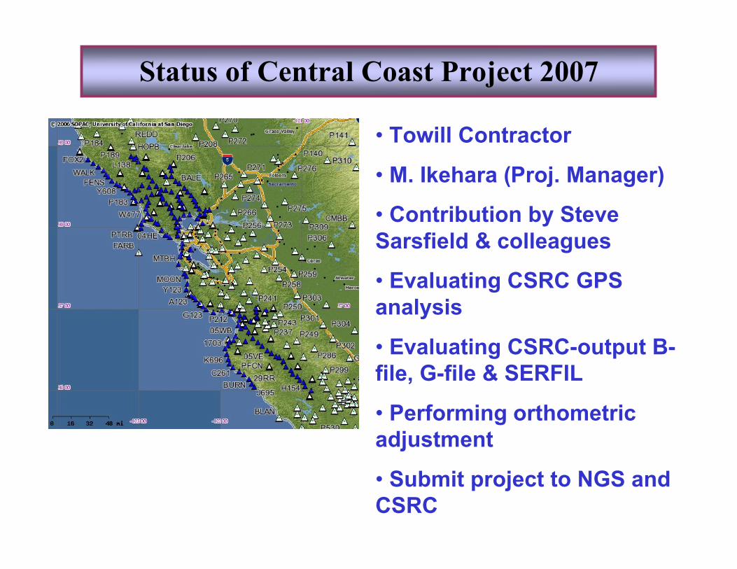
Status of Central Coast Project 2007
• Towill Contractor
• M. Ikehara (Proj. Manager)
• Contribution by SteveSarsfield & colleagues
• Evaluating CSRC GPSanalysis
• Evaluating CSRC-output B-file, G-file & SERFIL
• Performing orthometricadjustment
• Submit project to NGS andCSRC

Reference Frame Issues
• CSRC Epoch 2007.0 outputin ITRF2005, not ITRF2000 asposted.
• Feedback from MikePotterfield and others
• NGS notified
• CSRC web pages will bemodified accordingly
• Differences at the 5-10 mmlevel per coordinatecomponent