Embed Size (px)
Citation preview
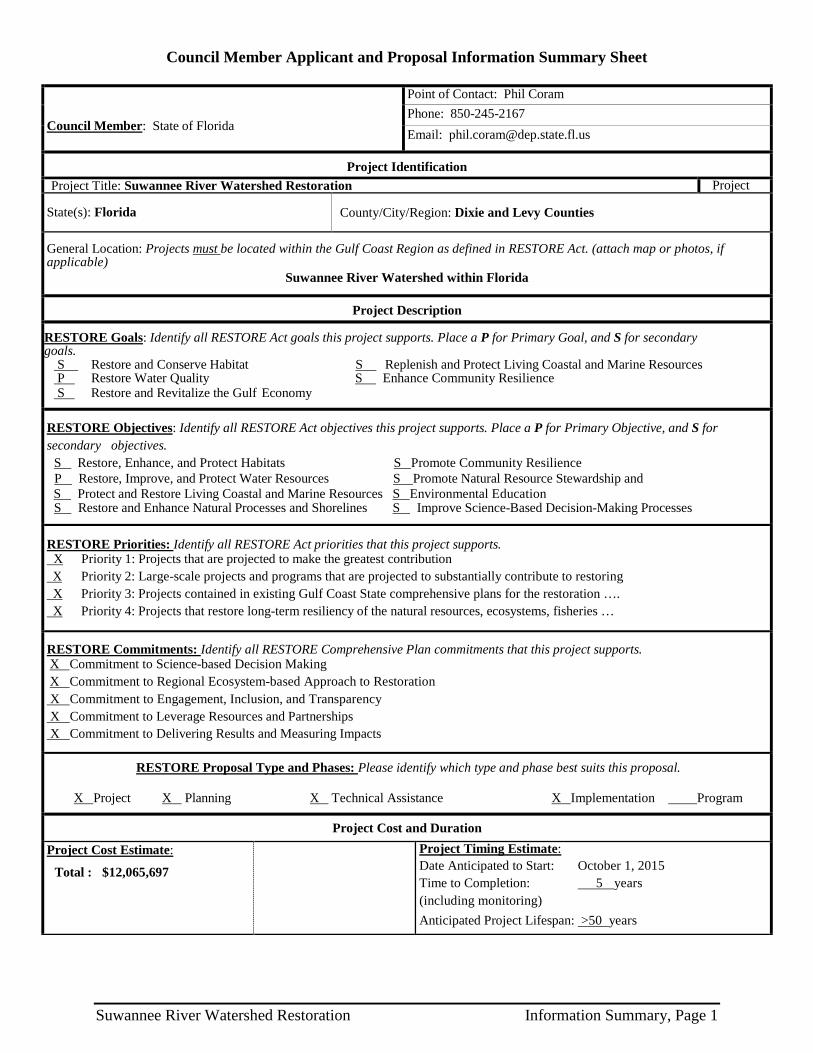
Council Member Applicant and Proposal Information Summary Sheet
Council Member: State of Florida
Point of Contact: Phil Coram Phone: 850-245-2167 Email: [email protected]
Project Identification Project Title: Suwannee River Watershed Restoration Project
State(s): Florida County/City/Region: Dixie and Levy Counties
General Location: Projects must be located within the Gulf Coast Region as defined in RESTORE Act. (attach map or photos, if applicable)
Suwannee River Watershed within Florida
Project Description
RESTORE Goals: Identify all RESTORE Act goals this project supports. Place a P for Primary Goal, and S for secondary goals.
S Restore and Conserve Habitat S Replenish and Protect Living Coastal and Marine Resources P Restore Water Quality S Enhance Community Resilience S Restore and Revitalize the Gulf Economy
RESTORE Objectives: Identify all RESTORE Act objectives this project supports. Place a P for Primary Objective, and S for secondary objectives.
S Restore, Enhance, and Protect Habitats S Promote Community Resilience P Restore, Improve, and Protect Water Resources S Promote Natural Resource Stewardship and
S Protect and Restore Living Coastal and Marine Resources S Environmental Education S Restore and Enhance Natural Processes and Shorelines S Improve Science-Based Decision-Making Processes
RESTORE Priorities: Identify all RESTORE Act priorities that this project supports. X Priority 1: Projects that are projected to make the greatest contribution X Priority 2: Large-scale projects and programs that are projected to substantially contribute to restoring X Priority 3: Projects contained in existing Gulf Coast State comprehensive plans for the restoration …. X Priority 4: Projects that restore long-term resiliency of the natural resources, ecosystems, fisheries …
RESTORE Commitments: Identify all RESTORE Comprehensive Plan commitments that this project supports. X Commitment to Science-based Decision Making X Commitment to Regional Ecosystem-based Approach to Restoration X Commitment to Engagement, Inclusion, and Transparency X Commitment to Leverage Resources and Partnerships X Commitment to Delivering Results and Measuring Impacts
RESTORE Proposal Type and Phases: Please identify which type and phase best suits this proposal.
X Project X Planning X Technical Assistance X Implementation Program
Project Cost and Duration
Project Cost Estimate:
Total : $12,065,697
Project Timing Estimate: Date Anticipated to Start: October 1, 2015 Time to Completion: 5 years (including monitoring) Anticipated Project Lifespan: >50 years
Suwannee River Watershed Restoration Information Summary, Page 1

Suwannee River Watershed Restoration and Preservation Proposal
Executive Summary
The Suwannee Watershed covers more than 7,700 square miles in north central Florida within all or part of 14 counties (Figure 1). Portions of the watershed extend into southern Georgia. It is one of Florida’s least populated areas and, for that reason, remains more biologically diverse and healthier than many other watersheds. The watershed encompasses the Upper Suwannee, Lower
Suwannee, Alapaha, Withlacoochee, Aucilla, Econfina–Steinhatchee, Santa Fe, and Waccasassa river basins. It contains a rich assortment of other surface waters—streams, springs, cypress ponds, swamps, and estuaries. There are many protected natural areas, including three national wildlife refuges, 10 state parks or preserves, other public lands, and the Big Bend Seagrasses Aquatic Preserve.
Unlike most of Florida, the coastal towns along the Big Bend have remained working waterfront communities. Horseshoe Beach, Suwannee, and Cedar Key are defined by their fishing families, who built
the industry in the early twentieth century and have kept it thriving, in part through aquaculture, until the present day. Shellfish harvesting and farming have enabled these communities to remain connected to the Gulf, allowing fishermen to continue to pass their water-related skills on to the next generation. The viability of the local aquatic economy, and the continuing vitality of the natural resources throughout the Big Bend, are critical to a vibrant tourist and eco-tourist economy into the future.
The Suwannee River Watershed proposal requests $12,065,697 and includes three projects that, collectively, will restore and protect water quality, water supplies and habitat; replenish living marine resources; and revitalize the local Gulf Coast economy—and the local communities that depend on those resources and that economy—and set them on a more sustainable, resilient footing for the future. Each project is briefly summarized below.
Figure 1. Suwannee River Watershed
Suwannee River Watershed Restoration Executive Summary, Page 1

Project 1. Restoring Resilience to Oyster Reefs in the Big Bend of Florida's Gulf Coast ($5,181,697)
Oyster Reefs play a critical role in keeping estuarine habitats healthy for fish and wildlife. The project targets restoration of oyster reef habitat along 7.2 miles of degraded coastline and 52,000 acres of salt marsh and seagrass beds to improve ecosystem function and services, including estuarine freshwater entrainment, living shoreline enhancement and fishery habitat improvement. Local materials that have a proven track record in restoring oyster reefs will be used for restoration, making them more resilient to changes in freshwater flows (Figure 2).
Project 2. Lower Suwannee & Gulf Watershed Conservation Easement ($4,000,000)
Acquiring conservation easements within this 46,500-acre component of the Florida Forever land acquisition program is a rare opportunity to protect a vast tract of land on Florida's Gulf Coast. The project will build on the success of the adjacent 32,000-acre California Lake Conservation Easement completed in 2001 and is directly adjacent to the Lower Suwannee National Wildlife Refuge and state conservation lands (Figure 3). It would protect a critical Gulf watershed along Florida’s nearly pristine Big Bend, enhance habitat for a variety of listed species and preserve an essential coastal wildlife corridor.
Project 3. Suwannee River Partnership Irrigation Water Enhancement Program ($2,884,000)
Nutrient loss from agricultural activities is a considerable environmental stressor to the Suwannee River and Estuary. This program builds on the Natural Resources Conservation Service’s (NRCS) Gulf of Mexico Initiative, which identified the middle Suwanee River as a priority area to reduce nutrient pollution. The Florida Department of Agriculture and Consumer Services will oversee and work with the Suwannee River Partnership to build on a successful pilot program to improve irrigation system efficiency similar to the NRCS’s Agricultural Water Enhancement Program. Improved irrigation systems reduce nutrient loading to water resources, improving water quality and, in turn, restoring and protecting
habitat (Figure 4). In addition, they conserve water and energy, which are essential to the viability of the agricultural operations and the local communities that depend on them for their livelihoods.
Figure 2. Oyster reef restoration
Figure 3. Conservation lands in the Lower Suwannee
Figure 4. Irrigation t
Suwannee River Watershed Restoration Executive Summary, Page 2

Proposal Narrative
The Suwannee Watershed covers more than 7,700 square miles in north central Florida within all or part of 14 counties, with portions of the watershed extending into Georgia. It is one Florida’s least populated areas and, for that reason, remains more biologically diverse and healthier than many watersheds. It contains a rich assortment of surface waters—rivers and streams, springs, cypress ponds, swamps, and estuaries—and an array of protected natural areas extending into the Gulf of Mexico and its seagrasses and oyster beds.
This proposal includes three projects that, collectively, will help restore and protect water quality, water supplies and habitat in the Suwannee Watershed; replenish living marine resources; and revitalize the local Gulf Coast economy—and the communities that depend on those natural resources and that economy—and set them on a more sustainable, resilient footing for the future. The three projects and requested funding amounts are:
1. Restoring Resilience to Oyster Reefs in the Big Bend of Florida's Gulf Coast ($5,181,697) 2. Lower Suwannee & Gulf Watershed Conservation Easement ($4,000,000) 3. Suwannee River Partnership Irrigation Water Enhancement Program ($2,884,000)
Each project extends the benefits of projects and programs already proven successful in the watershed. Collectively, their primary goal is to restore and conserve habitat with the corresponding primary objective to restore, enhance and protect habitat. They will accomplish these ends by restoring water resources, reducing excessive nutrients, and replenishing and protecting coastal and marine resources through conservation of coastal lands and restoration of oyster reef habitat—and in doing so, will achieve the complete set of Council goals and objectives. These actions in turn will help revitalize the local Gulf Coast economy, which depends on oystering and other marine-based products as well as tourism and silviculture, and promote the resilience and sustainability of local communities throughout the watershed.
The projects are interrelated. In the Suwannee River Basin, the economy is strongly based on silviculture, aquaculture, commercial and sport fishing, and ecotourism. Each depends on healthy river and estuary conditions, which are threatened by excessive nutrient levels, loss of habitat, altered coastal functions, and an imbalance of saline and freshwater in the estuaries. The main cause of oyster reef degradation is decreased freshwater flow from the Suwannee River, and the extensive coastal seagrass beds, a pillar of sport and commercial fishing, demand clean water and balanced estuarine conditions.
The Suwannee Watershed proposal represents a large-scale, regional approach to solving critical water resource and habitat threats to the Florida Gulf Coast. The projects address the problem in an integrated way, enhancing community resilience and sustainability. Restoration of oyster beds results in greater freshwater entrainment in the estuary, helps clean coastal waters and expands and protects nursery habitat for fisheries. Large scale conversion of irrigation to lower water volumes and less fertilizer use addresses both loss of freshwater and excess nutrient levels that cause water quality problems. The large tracts of forest targeted for conservation contribute directly to the freshwater budget of the coastal region without removing the market value of continuing sustainable silviculture. As the individual project summaries demonstrate, each one is founded on good scientific principles or other proven actions and methods that have achieved successful,
Suwannee River Watershed Restoration Proposal Narrative, Page 1

measurable results. They leverage other resources and build on past investments to extend their impact. Each project is summarized below.
Project 1. Restoring Resilience to Oyster Reefs in the Big Bend of Florida's Gulf Coast ($5,181,697)
As the most technically complicated of the three projects, oyster reef restoration requires the most extensive explanation.
Background – Oyster reefs are significant biological communities that support considerable biodiversity, provide keystone habitat for juvenile fish, forage fish, invertebrates, and birds, and support economically important fisheries (Coen et al. 2007). Oyster reefs function as barrier islands in many areas, dampening wave action to reduce coastal erosion and protect coastal communities from storm damage (Scyphers et al. 2011). Oyster reefs are probably the most highly impacted marine habitat in the world, and though populations in the Gulf of Mexico are degraded, they remain some of the best habitat globally (Beck et al. 2011). Oyster reefs in Florida’s Big Bend exist in a coastal region unique in the Gulf of Mexico because of low energy shoreline habitats dominated by seagrass meadows and oyster reefs, low human population density, and high percentage of coastline under state or federal management. Although this is the largest stretch of undeveloped coastline in the continental U.S., oyster reef area has been reduced by 66-88% during the past 30 years (Seavey et al. 2011). Because the area has such high conservation value and otherwise excellent habitat conditions, understanding and restoring these populations has high value for interpreting background conditions elsewhere in the Gulf.
Recent evidence (Seavey et al. 2011) suggests that reductions in freshwater flow triggers a cascading decline in oyster reef resilience mediated by high mortality rates due to disease and predation, eventual loss of oyster settlement substrate, and conversion of oyster reefs to sandbars. Once these reefs lose their covering of durable, living shell, they begin to break apart, spread out and rapidly (cf 15 cm/yr) lose elevation, and become shifting sandbars. Entire chains of reefs have become truncated, with less than half the original area remaining, and gaps between reefs have enlarged from 25 m to 900m. This general sequence has been repeated in over 30 long-term monitoring stations in the area and appears to be irreversible through natural dynamism. Re-establishment and maintenance of these historic oyster reefs (cf 3,500 years old, see Grinnell 1972) requires that 1) suitable, durable substrate is provided as foundation, and 2) oyster shell substrate accrues through constant recruitment and natural mortality (i.e., positive shell budget).
A resilient restoration strategy depends on understanding conditions resulting in loss. Decline of oyster reefs in this area has been linked to repeated episodes of reduced freshwater inputs, resulting in high salinity and associated mortality events from disease and predation (Seavey et al. 2011). While eastern oysters are capable of enduring wide variation in salinity (5-30 practical salinity units) for long portions of each year, there are temporal limits to their physiological endurance. In this region the major source of freshwater and estuarine conditions is the Suwannee River, and its levels also determine seepage and spring flow of fresh water across a wide section of coastline. Frequency of low river discharge events in the Suwannee River (< 1 standard deviation below period of record monthly means) has increased by approximately one order of magnitude during the period from 1995-2008 compared to the previous 55 years. Since annual rainfall has not
Suwannee River Watershed Restoration Proposal Narrative, Page 2
changed appreciably in the Suwannee drainage basin, human use of freshwater is most likely the driver of change in discharge (Seavey et al. 2011).
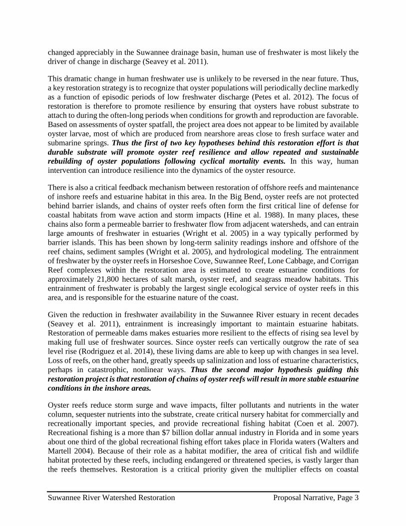
This dramatic change in human freshwater use is unlikely to be reversed in the near future. Thus, a key restoration strategy is to recognize that oyster populations will periodically decline markedly as a function of episodic periods of low freshwater discharge (Petes et al. 2012). The focus of restoration is therefore to promote resilience by ensuring that oysters have robust substrate to attach to during the often-long periods when conditions for growth and reproduction are favorable. Based on assessments of oyster spatfall, the project area does not appear to be limited by available oyster larvae, most of which are produced from nearshore areas close to fresh surface water and submarine springs. Thus the first of two key hypotheses behind this restoration effort is that durable substrate will promote oyster reef resilience and allow repeated and sustainable rebuilding of oyster populations following cyclical mortality events. In this way, human intervention can introduce resilience into the dynamics of the oyster resource.
There is also a critical feedback mechanism between restoration of offshore reefs and maintenance of inshore reefs and estuarine habitat in this area. In the Big Bend, oyster reefs are not protected behind barrier islands, and chains of oyster reefs often form the first critical line of defense for coastal habitats from wave action and storm impacts (Hine et al. 1988). In many places, these chains also form a permeable barrier to freshwater flow from adjacent watersheds, and can entrain large amounts of freshwater in estuaries (Wright et al. 2005) in a way typically performed by barrier islands. This has been shown by long-term salinity readings inshore and offshore of the reef chains, sediment samples (Wright et al. 2005), and hydrological modeling. The entrainment of freshwater by the oyster reefs in Horseshoe Cove, Suwannee Reef, Lone Cabbage, and Corrigan Reef complexes within the restoration area is estimated to create estuarine conditions for approximately 21,800 hectares of salt marsh, oyster reef, and seagrass meadow habitats. This entrainment of freshwater is probably the largest single ecological service of oyster reefs in this area, and is responsible for the estuarine nature of the coast.
Given the reduction in freshwater availability in the Suwannee River estuary in recent decades (Seavey et al. 2011), entrainment is increasingly important to maintain estuarine habitats. Restoration of permeable dams makes estuaries more resilient to the effects of rising sea level by making full use of freshwater sources. Since oyster reefs can vertically outgrow the rate of sea level rise (Rodriguez et al. 2014), these living dams are able to keep up with changes in sea level. Loss of reefs, on the other hand, greatly speeds up salinization and loss of estuarine characteristics, perhaps in catastrophic, nonlinear ways. Thus the second major hypothesis guiding this restoration project is that restoration of chains of oyster reefs will result in more stable estuarine conditions in the inshore areas.
Oyster reefs reduce storm surge and wave impacts, filter pollutants and nutrients in the water column, sequester nutrients into the substrate, create critical nursery habitat for commercially and recreationally important species, and provide recreational fishing habitat (Coen et al. 2007). Recreational fishing is a more than $7 billion dollar annual industry in Florida and in some years about one third of the global recreational fishing effort takes place in Florida waters (Walters and Martell 2004). Because of their role as a habitat modifier, the area of critical fish and wildlife habitat protected by these reefs, including endangered or threatened species, is vastly larger than the reefs themselves. Restoration is a critical priority given the multiplier effects on coastal
Suwannee River Watershed Restoration Proposal Narrative, Page 3

resources essential to the economy and ecology of the Big Bend. Within the project region, the ratio of restored reef to restored estuarine habitat is estimated at 1:670.
This project addresses a central problem for oyster reef management and restoration throughout the Gulf. Most large estuaries emptying into the Gulf receive reduced freshwater inputs because of upstream water use and management. Reductions may increase in the future and may be exacerbated by sea level rise (examples include Florida Bay, Charlotte Harbor, Tampa Bay, Suwannee Sound, Apalachicola Bay, Mobile Bay, Galveston Bay, Corpus Christi Bay, and Laguna Madre). Because freshwater loss has been isolated as the only major driver of oyster populations in the otherwise pristine Big Bend, it is a test location for making oyster populations resilient in salinizing estuaries. This project is foundational for future work in this and other Gulf locations because it tests two basic premises under conditions of reduced freshwater inputs and salinizing estuaries: 1) that highly durable substrate will allow repeated recruitment of oysters following episodic low freshwater flow events, and 2) that chains of oyster reefs can be used as aquascaping tools at large spatial scales to retain freshwater for inshore estuaries.
Implementation methodology – A broadly supported restoration strategy from industry, resource managers, and scientists for restoring these keystone ecological habitats in the Big Bend region is to 1) restore chains of reefs closest to sources of freshwater to promote persistence of oysters even during drought, and 2) provide durable substrate to promote resilience of oyster reefs which will enable oysters to recruit both now and in the wake of future mortality events. The interventions proposed here are based on restoring oyster reefs in locations where previous research suggests extant reefs have recently collapsed (Seavey et al. 2011). Data indicate that these reefs are currently not recruitment limited (there is sufficient juvenile oyster spat from nearshore oyster bars) and are not likely to regenerate to oyster reefs naturally due to the absence of stable substrate. Two pilot restoration projects during 2007-2014 and 2009-2014 suggest that this approach is very likely to be successful. The substrate used will also provide economic benefits to the local shellfish industry via rehabilitation of shellfish leases.
Two forms of durable substrate will be used: limerock boulders and recycled clam aquaculture bags containing shell cultch, living oysters, and other encrusting organisms. These ~180-kg mesh bags were used to grow cultured hard clams (Mercenaria mercenaria) on lands leased from the State of Florida by commercial clam farmers. During storm or extreme weather events, many of the clams die and the shell becomes colonized by oysters and other species – an average of 8,000 living oysters per bag has been recorded. The bags are often then abandoned by the clam industry because it is cheaper and easier to use new bags than to reclaim older, encrusted bags for re-use in clam farming. More than 20,000 encrusted bags are estimated to be currently available for use. These bags and their living contents therefore represent ready-made oyster reef building blocks that are extremely durable in the face of wave action.
The project will employ a traditional restoration approach of adding recycled shell material to increase available settlement substrate on oyster reefs. Using shell material as cultch to enhance oyster recruitment and survival has a long history in Florida (Berrigan et al. 1991). This high quality shell will be used to fill in spaces between lime rock boulders and in low energy sites where wave action is unlikely to move shell from deposition sites.
Suwannee River Watershed Restoration Proposal Narrative, Page 4
The third restoration substrate material is locally available limestone boulders. Florida’s west coast is a karst limestone platform, and exposed limestone is common in submerged habitat. Oysters commonly grow on the limestone and Hine et al. (1988) identified the rock outcroppings as key bases for development of oyster reefs. Local examples indicate that natural aggregations of limerock exist in areas of high wave action and can recruit oysters following periods of low freshwater input. In Suwannee Sound, however, oyster reefs are based primarily on riverine sediments (Wright et al. 2005) that are much less stable and do not provide the persistent nucleation site for oyster settlement provided by limestone (Hine et al. 1988). The project’s strategy combines both materials using a mix of clam bags and limestone to create stable structure with complex interstitial spaces to provide persistent nucleation sites for oyster settlement, growth, and reef formation. Using these materials also avoids competition with other projects for scarce stocks of natural or fossil shell.
The project team has also demonstrated the efficacy of these restoration techniques via pilot restoration projects. In 2007-2009, a 0.07-hectare oyster reef was built using 4,200 clam bags recovered from clam leases near the town of Cedar Key to help limit erosion of cultural sites at Aetsena Otie Key. This oyster reef has proved to be both ecologically viable, with a full suite of oyster reef-associated flora and fauna and robust growth of oysters, and resilient in a high wave action and high tidal flow zone. Oyster densities on this reef also remained high during and following a region-wide mortality event from 2011-2013.
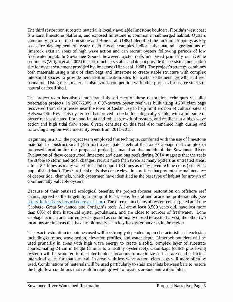
Beginning in 2013, the project team employed this technique, combined with the use of limestone material, to construct small (455 m2) oyster patch reefs at the Lone Cabbage reef complex (a proposed location for the proposed project), situated at the mouth of the Suwannee River. Evaluation of these constructed limestone and clam bag reefs during 2014 suggests that the reefs are stable to storm and tidal changes, recruit more than twice as many oysters as untreated areas, attract 2.4 times as many waterbirds, and support 18 times as many juvenile blue crabs (Frederick unpublished data). These artificial reefs also create elevation profiles that promote the maintenance of deeper tidal channels, which oystermen have identified as the best type of habitat for growth of commercially valuable oysters.
Because of their outsized ecological benefits, the project focuses restoration on offshore reef chains, agreed as the targets by a group of local, state, federal and academic professionals (see http://floridarivers.ifas.ufl.edu/oyster.htm). The three main chains of oyster reefs targeted are Lone Cabbage, Great Suwannee, and Corrigan’s reefs. All are at least 3,500 years old, have lost more than 80% of their historical oyster populations, and are close to sources of freshwater. Lone Cabbage is in an area currently designated as conditionally closed to oyster harvest; the other two locations are in areas that have traditionally been key for oyster harvests in the region.
The exact restoration techniques used will be strongly dependent upon characteristics at each site, including currents, wave action, elevation profiles, and water depth. Limerock boulders will be used primarily in areas with high wave energy to create a solid, complex layer of substrate approximating 24 cm in height (similar to a healthy oyster reef). Clam bags (cultch plus living oysters) will be scattered in the inter-boulder locations to maximize surface area and sufficient interstitial space for spat survival. In areas with less wave action, clam bags will more often be used. Combinations of materials will be used particularly to stabilize inlets between bars to restore the high flow conditions that result in rapid growth of oysters around and within inlets.
Suwannee River Watershed Restoration Proposal Narrative, Page 5
Rocks and bags will be moved to offshore restoration sites using a barge and placed using a small onboard trackhoe or crane with extended arm. Smaller sites in shallow water will be reached using local shallow draft fishing boats that are typically used to move large amounts of shell and clam aquaculture materials. Local oystermen will be subcontracted to help move materials when possible to reduce local underemployment and benefit from their expertise and equipment. Rock will most often be placed in the water during early and late summer when spatfall on the clean material is most likely to occur. Clam bags can be moved at any time of year since the cultch is already encrusted with oysters and meiofauna.
Monitoring and adaptive management – The project will monitor before, during, and after restoration, measuring size and elevation of reefs, densities and sizes of oysters, and rates of colonization, growth, and water flow. Since the full effects of oyster restoration may take at least two growing seasons to become measurable, monitoring will be for a minimum of 24 months following the cessation of restoration activities. The project is enhanced by previous scientific work conducted by University of Florida Institute of Food and Agricultural Services (IFAS) on oyster communities in the area, such that monitoring metrics and techniques have already been developed, elevations established, and comparisons made possible across a suite of 36 sampling sites that encompass gradients of salinity, elevation, and wave energy. This allows considerable ability to interpret results and separate effects of restoration from effects of weather and natural variation.
One of the most important predicted effects of this restoration project is that salinities will be reduced by comparison with no restoration, due to the damming effect of linear chains of restored reefs. The prediction will be assessed via two approaches. First, modeling already underway is directed at predicting salinities on the landward side of the restored chains with and without restored reef elevations and reef area. It is being validated through the use of salinity, tidal and river flow data collected onsite. Second, two of the main chains of reefs targeted for restoration (Lone Cabbage and Great Suwannee) effectively funnel entrained freshwater to the south and east, where the effect can be measured by the CLAMMRS (Clam Lease Assessment, Monitoring, And Modeling Using Remote Sensing) water quality monitoring site to the north and west of Cedar Key. This latter method, while direct, will require a long time series in order to match rainfall and flow events during restored and unrestored conditions.
A second key prediction is that restored sites will be more resilient following low flow events than unrestored sites. At least one low flow event is projected to occur during the course of this project (6 years); from 1998-2008, low flow events occurred during 4.23 months/year, on average (Seavey et al. 2011). The comparison of oyster densities, mortality, size, and areal coverage on restored and unrestored sites should therefore be adequate for testing the prediction.
Monitoring oyster reef success will rely on standardized measures used in other projects (Baggett et al. 2014), including monitoring unrestored wild reefs and pilot restoration projects in the project area. Measures include oyster densities, oyster sizes, and live:dead oyster ratios collected using random spatial sampling techniques (e.g. belt transects, random ¼ m2 quadrat throws). In addition, the project will monitor elevation change on oyster reefs using laser level measurements or RTK GPS surveys keyed to true elevation benchmarks established on reefs.
Suwannee River Watershed Restoration Proposal Narrative, Page 6
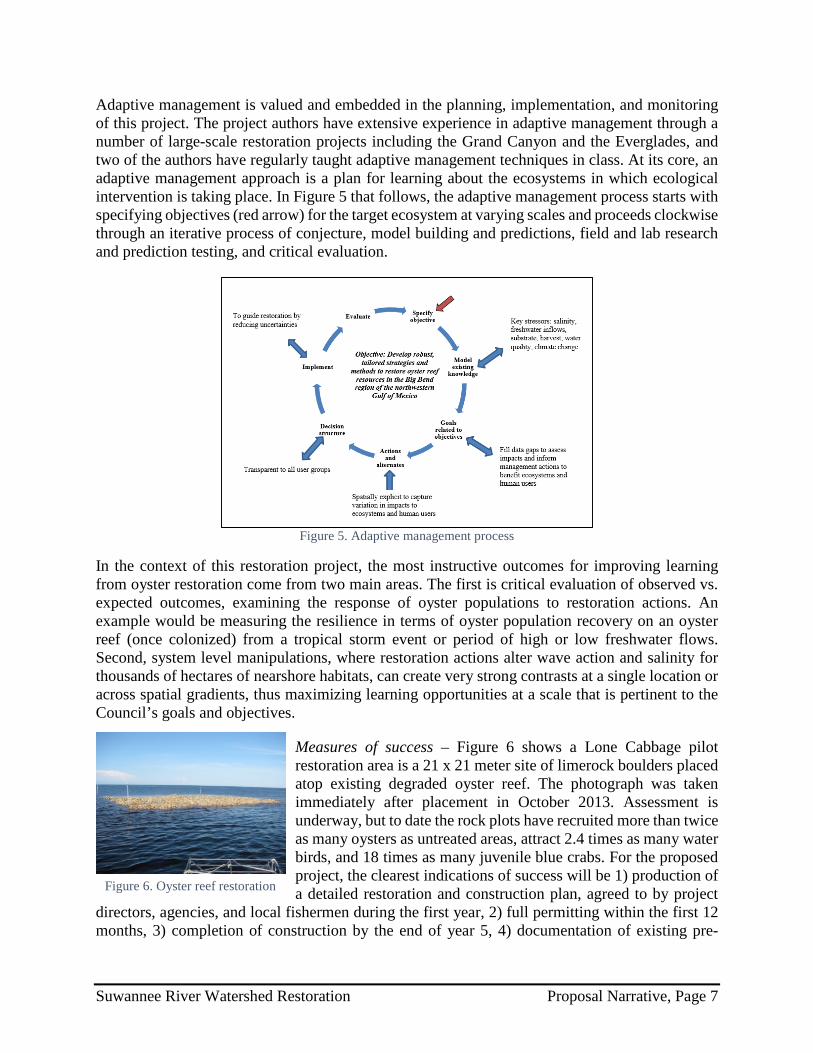
Adaptive management is valued and embedded in the planning, implementation, and monitoring of this project. The project authors have extensive experience in adaptive management through a number of large-scale restoration projects including the Grand Canyon and the Everglades, and two of the authors have regularly taught adaptive management techniques in class. At its core, an adaptive management approach is a plan for learning about the ecosystems in which ecological intervention is taking place. In Figure 5 that follows, the adaptive management process starts with specifying objectives (red arrow) for the target ecosystem at varying scales and proceeds clockwise through an iterative process of conjecture, model building and predictions, field and lab research and prediction testing, and critical evaluation.
Figure 5. Adaptive management process
In the context of this restoration project, the most instructive outcomes for improving learning from oyster restoration come from two main areas. The first is critical evaluation of observed vs. expected outcomes, examining the response of oyster populations to restoration actions. An example would be measuring the resilience in terms of oyster population recovery on an oyster reef (once colonized) from a tropical storm event or period of high or low freshwater flows. Second, system level manipulations, where restoration actions alter wave action and salinity for thousands of hectares of nearshore habitats, can create very strong contrasts at a single location or across spatial gradients, thus maximizing learning opportunities at a scale that is pertinent to the Council’s goals and objectives.
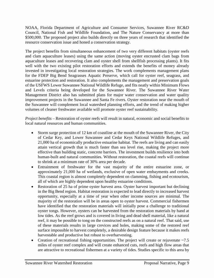
Measures of success – Figure 6 shows a Lone Cabbage pilot restoration area is a 21 x 21 meter site of limerock boulders placed atop existing degraded oyster reef. The photograph was taken immediately after placement in October 2013. Assessment is underway, but to date the rock plots have recruited more than twice as many oysters as untreated areas, attract 2.4 times as many water birds, and 18 times as many juvenile blue crabs. For the proposed project, the clearest indications of success will be 1) production of a detailed restoration and construction plan, agreed to by project
directors, agencies, and local fishermen during the first year, 2) full permitting within the first 12 months, 3) completion of construction by the end of year 5, 4) documentation of existing pre-
Figure 6. Oyster reef restoration
Suwannee River Watershed Restoration Proposal Narrative, Page 7

construction conditions within the first year, 5) achievement of a regular monitoring program for restored and comparable unrestored reefs and comprehensive salinity and water quality grids, and 6) documentation of restored conditions sufficient to test predictions of the two hypotheses stated in the background section.
Risks and uncertainties – This project is strongly supported by the results of two major pilot studies that have constructed reefs in the project area using the same techniques. Thus, the techniques are proven in the region where they will be deployed. The prediction that restored reef chains can entrain freshwater is supported strongly by salinity measurements and modeled results. If there is an uncertainty here, it is only the numerical prediction of how much freshwater will be entrained under specific conditions, which will require further measurement and model development. Nonetheless the conclusion about significant entrainment is robust.
The most important uncertainty has to do with the effects of oyster harvest on restored reefs. The Lone Cabbage site is within a closed harvest area, but the other two sites are harvestable. Examples around the Gulf have shown that even successfully restored sites can be devastated by poor harvest management. There is little uncertainty in the derivation of an appropriate harvest management plan—only the mechanism by which it will be effectively overseen.
Outreach and education opportunities – The project has received broad public acceptance in Suwannee and Cedar Key based on 1) response to four public talks given during the last 18 months, 2) results of a group meeting of state, federal, and private stakeholders (see http://floridarivers.ifas.ufl.edu/oyster.htm), 3) response to public notice of Lone Cabbage restoration, and 4) generally favorable response to construction of the Atsena Otie reef.
The project extends the partnership built through the Suwannee River Partnership in the mid-2000s, which resulted in the Atsena Otie reef project. The Partnership will function in much the same capacity now: organizational structure for cooperative relationships with governmental agencies, resource managers, universities and other educational institutions, clam farmers, oyster harvesters, and local businesses. The collaborating entities support the project and will be involved in an advisory or participatory manner. They include the Cedar Key Aquaculture Association, Cedar Key Oysterman’s Association, Suwannee Oystermen’s Association, Suwannee River Water Management District, Board of County Commissioners of Levy and Dixie Counties, and the City of Cedar Key (see letters of support in the Other section).
The project is a unique, powerful opportunity to educate the public and stakeholders about coastal restoration. It includes education and outreach to engage the public, volunteers, school groups, user groups, and media outlets through press publications, a web site, television and radio spots, educational events, and public involvement in restoration and monitoring activities. For example, a portion of the clean cultch will be collected locally during area festivals and from seafood restaurants in the form of oyster and clamshell, engaging festival-goers and restaurant owners, workers and clients. Public talks, school group visits to restoration sites, and media events are also planned at the beginning and completion of construction on each reef complex.
Leveraging of resources and partnerships – One restoration effort has been completed in the area (Atsena Otie reef) and another is underway (Lone Cabbage reef complex). These relatively small-scale demonstration projects have been funded by various state and federal agencies including
Suwannee River Watershed Restoration Proposal Narrative, Page 8
NOAA, Florida Department of Agriculture and Consumer Services, Suwannee River RC&D Council, National Fish and Wildlife Foundation, and The Nature Conservancy at more than $500,000. The proposed project also builds directly on three years of research that identified the resource conservation issue and honed a conservation strategy.
The project benefits from simultaneous enhancement of two very different habitats (oyster reefs and clam aquaculture leases) using the same action (moving oyster encrusted clam bags from aquaculture leases and recovering clam and oyster shell from shellfish processing plants). It fits well with the two existing pilot restoration efforts and extends the benefits of money already invested in investigating local restoration strategies. The work complements management plans for the FDEP Big Bend Seagrasses Aquatic Preserve, which call for oyster reef, seagrass, and estuarine protection and restoration. It also complements the management and preservation goals of the USFWS Lower Suwannee National Wildlife Refuge, and fits neatly within Minimum Flows and Levels criteria being developed for the Suwannee River. The Suwannee River Water Management District also has submitted plans for major water conservation and water quality improvement projects in the Suwannee and Santa Fe rivers. Oyster restoration near the mouth of the Suwannee will complement local watershed planning efforts, and the trend of making higher volumes of cleaner freshwater available will promote oyster reef sustainability.
Project benefits – Restoration of oyster reefs will result in natural, economic and social benefits to local natural resources and human communities.
• Storm surge protection of 12 km of coastline at the mouth of the Suwannee River, the City of Cedar Key, and Lower Suwannee and Cedar Keys National Wildlife Refuges, and 21,000 ha of economically productive estuarine habitat. The reefs are living and can easily attain vertical growth that is much faster than sea level rise, making the project more effective than building static, concrete barriers. The investment builds resilience into both human-built and natural communities. Without restoration, the coastal reefs will continue to shrink at a minimum rate of 30% area per decade.
• Entrainment of freshwater for the vast majority of the entire estuarine zone, or approximately 21,000 ha of wetlands, exclusive of open water embayments and creeks. This coastal region is almost completely dependent on clamming, fishing and ecotourism, all of which are highly dependent upon healthy estuarine conditions.
• Restoration of 25 ha of prime oyster harvest area. Oyster harvest important but declining in the Big Bend region. Habitat restoration is expected to lead directly to increased harvest opportunity, especially at a time of year when other income sources are minimal. The majority of the restoration will be in areas open to oyster harvest. Commercial fishermen have identified that the restoration materials will initially pose a challenge to traditional oyster tongs. However, oysters can be harvested from the restoration materials by hand at low tides. As the reef grows and is covered in living and dead shell material, like a natural reef, it may be possible to tong on the constructed reefs as on a natural reef. That said, use of these materials results in large crevices and holes, making some of the restored reef surface impossible to harvest completely, a desirable design feature because it makes reefs harvestable and productive but robust to overharvesting.
• Creation of recreational fishing opportunities. The project will create or rejuvenate ~7.5 miles of oyster reef complex and will create enhanced cuts, reefs and high flow areas that are attractive to recreational fishermen at a variety of tides. Studies specific to this area by
Suwannee River Watershed Restoration Proposal Narrative, Page 9
the Florida Fish and Wildlife Conservation Commission have demonstrated that recruitment of target sport fish (e.g., sea trout, redfish, grouper) are highly dependent on local inshore salinity regimes, with higher recruitment in more estuarine conditions. This indicates a clear link between the restoration of oyster reef chains that embay and hold fresh water near the coast, and the local production of sport fish.
• Reclamation of valuable state aquaculture leases. Producing hard clams on coastal submerged lands is an economically important industry in the Big Bend, with an impact to the area reported at $35 million in 2008. Over 200 acres, including a minimum of 100 shellfish aquaculture leases, are expected to be partially reclaimed through removal of clam bags. Removing these bags will provide positive services to the state and clam farmers by 1) restoring the ecological and commercial value of state-owned submerged lands, 2) assisting clam farmers in clearing and preparing the leases for replanting new crops, and 3) accelerating the recovery of farmers from crop losses.
• Local economic improvement. The project will provide employment for local workers and fishermen. The waters in the project area are extremely shallow and impossible to work in without local knowledge and local craft. It will typically be difficult and inefficient to employ outsiders in restoration, meaning the vast majority of employment stemming from the project is expected to be local. The longer term and sustainable effects to local businesses and workers will include enhanced oyster harvest, enhanced sport and commercial fishing, and more competitive clam aquaculture economics. Growth in local businesses that serve tourist, sportfish, clam aquaculture, and commercial oyster harvest industries are also expected to grow.
Project 2. Lower Suwannee & Gulf Watershed Conservation Easement ($4,000,000)
Background – The Lower Suwannee River & Gulf Watershed Conservation Easement is a rare opportunity to protect a vast tract on Florida’s Gulf coast. The property will be secured through the Florida Forever acquisition program (http://www.dep.state.fl.us/lands/fl_forever.htm), with property interest vested in the name of the Board of Trustees of the Internal Improvement Trust Fund of the State of Florida (Florida Cabinet).
The proposed 5,800-acre conservation easement is located within the Lower Suwannee River and Gulf Watershed Florida Forever project, which consists of 46,500 acres owned by Lyme Cross City Forest Company, LLC. The project ranks high under Florida Forever program priorities and represents a tremendous asset as a water and land conservation project in a priority tidewater watershed directly adjacent to the Lower Suwannee National Wildlife Refuge, Florida’s Big Bend Wildlife Management Area, and Suwannee River Water Management District’s California Lake conservation easement. It is immediately upstream of the Big Bend Seagrass Aquatic Preserve and will greatly expand the contiguous protected area along Florida’s pristine Big Bend.
Implementation methodology – Florida Forever program staff has researched the property and begun developing the easement. After easement language is agreed upon, appraisals will be requested to begin price negotiations. When a price is agreed upon, the contract is submitted to the Board of Trustees of the Internal Improvement Trust Fund at a regularly scheduled Cabinet meeting. Additional due diligence (title commitment, survey, if needed, and environmental site assessment/baseline documentation report) will be undertaken before a closing date is set.
Suwannee River Watershed Restoration Proposal Narrative, Page 10

The site will continue to be owned and managed by the private landowner and the easement will be monitored by the Suwannee River Water Management District or a partnership between the district and the state. Approximately half of the project (~24,000 acres) has been managed for commercial timber production. An almost equal area (~22,000 acres) comprises a matrix of forested wetlands, much of which has not been logged in recent history. The forested wetlands will never be harvested under the terms of the proposed easement.
Monitoring and adaptive management – Monitoring will be performed in cooperation between the Florida Department of Environmental Protection (Office of Environmental Services) and the Suwannee River Water Management District. The Florida Forever Program and the Division of State Lands already provides oversight for some 12 million acres of public lands. The perpetual oversight and monitoring of these state-owned or managed lands assures that they achieve the conservation goals and objectives that established their priority for acquisition
Measures of success – The direct measure of success is closing on the final acquisition of the conservation easement, bringing it under the purview of the Florida Forever Program, which will all the conservation values of the property to succeed.
Risks and uncertainties – There is little risk or uncertainty associated with the project. The property is owned by a single, willing, conservation-minded seller who understands the benefits the easement brings to the entire community. The Conservation Easement acquisition has widespread support in the local community. The project is adjacent to already successful natural areas, including the adjacent 32,000-acre California Lake Conservation Easement, the Lower Suwannee National Wildlife Refuge, and the Big Bend Wildlife Management Area, and will create a contiguous protected area of 196,000 acres. The tract is also adjacent to the Big Bend Seagrasses Aquatic Preserve, the largest contiguous area of seagrasses in the eastern Gulf of Mexico at 945,000 acres.
Outreach and education – A portion of the property along California Lake (~10 acres), where there is currently limited public access and a paddling trail that connects to the National Wildlife Refuge, will be conveyed to the state as a public park.
Leveraging of resources and partnerships – The Conservation Easement was approved as a Florida Forever project in 2010 and is listed as a high priority project in the 2013 work plan. The Suwannee River Water Management District was a co‐applicant on the Florida Forever application, along with The Conservation Fund, which prepared the application and continues to coordinate the project. Dixie County has been pursuing RESTORE Act funds for conservation and park access infrastructure and repairs. The following entities have expressed support for the project Dixie County, Dixie County Chamber of Commerce, Nature Coast Tourism Council, local hunt clubs, U.S. Fish & Wildlife Service, Florida Wildlife Federation, Florida Audubon Society, Florida Defenders of the Environment, Florida’s Nature Coast Conservancy, Friends of the Lower Suwannee National Wildlife Refuge, and the Florida Forestry Association.
The conservation easement will provide for pine uplands to be managed as a working forest and follow Florida’s silviculture best management practices. It will specify that hardwood hammocks, cypress, and wetland forests would no longer be harvested and become special natural areas.
Suwannee River Watershed Restoration Proposal Narrative, Page 11
Project benefits – The Lower Suwannee Conservation Easement will buffer and protect a vast swath of conservation lands, creating a contiguous protected area totaling 196,000 acres. It contains habitat for the Florida black bear, swallow‐tailed kite, Eastern indigo snake, Gulf sturgeon, a multitude of fish species, and an abundance of migratory birds. The area is within the national priority areas for waterfowl, water birds, and land birds and the project has also been selected as a priority gulf conservation project by National Audubon Society.
The project will also protect and enhance habitat within the Lower Suwannee National Wildlife Refuge and aquatic ecosystems located just off shore. These areas, including the Big Bend Seagrasses Aquatic Preserve, provide vital habitat for federally listed species like the Gulf sturgeon, West Indian manatee, green, loggerhead, and Kemp’s Ridley sea turtles, piping plover; and Wood stork, to name a few. The area is rich in creeks that flow across the subject tract and into the National Wildlife Refuge. It is also home to ecologically and economically important species, such as mullet, sea trout, red fish, scallops, oysters, Cedar Key clams, pink shrimp, blue crab, and others. The Suwannee River region contains essential fish habitat and the most viable population of the threatened Gulf sturgeon. The Aquatic Preserve’s seagrass beds and salt marshes provide nursery areas for finfish and shellfish, as well as foraging areas for those species and manatee, sea turtles, sturgeon, dolphin, and a host of birds.
The conservation easement will limit development and adverse land uses in perpetuity, while allowing the landowner to sustainably harvest timber in accordance with Florida’s silviculture best management practices. It will enhance eco‐tourism in the region by protecting the surface waters in which residents and visitors swim, fish, scallop, farm clams, oyster, and boat. As noted, a portion of the property along California Lake with a paddling trail that connects to the National Wildlife Refuge will be conveyed to the state as a public park.
The local communities realize that natural areas like this are not only ecologically important and worthy of restoration and preservation in their own right but also are significant economic drivers. The timber industry is Suwannee County’s largest employer, with the Suwannee Lumber Mill having an annual local payroll of more than $7 million. The project will ensure that important, sustainable forestry jobs stay in the community.
Project 3. Suwannee River Partnership Irrigation Water Enhancement Program ($2,884,000)
Background – The Suwannee River Partnership (Partnership), assisted by soil and water conservation districts throughout the Suwannee River Water Management District, received funding in 2009 from the USDA-NRCS to establish and develop an irrigation system efficiency improvement program under the Agricultural Water Enhancement Program. A small fraction of the producers that applied were funded due to overwhelming demand and a reduction in program funding. In 2011, the Suwannee River Water Management District declared four sub-basins of the Suwannee River as Water Use Caution Areas. The 2012 United States Census of Agriculture estimated that there are close to 90,000 irrigated acres in Suwannee Basin with an estimated 100 million gallons of water per day used for irrigation.
The project will help producers that have not received funding improve the efficiency of irrigation systems, reducing water use and nutrient loss to surface waters in the Suwannee Watershed. The work includes converting irrigation systems from high to low pressure; retrofitting center-pivot
Suwannee River Watershed Restoration Proposal Narrative, Page 12

irrigation systems with efficient spray nozzles; repairing leaks and end guns; installing end-gun shutoffs; and converting older diesel power units and pumps to more efficient diesel or electric power units for reduced air emissions and fuel savings, and upgrading irrigation controller equipment to allow for remote access.
Implementation methodology – Funding will supplement existing state and federal programs that operate on limited resources. The Florida Department of Agriculture and Consumer Services (FDACS) is responsible for developing and expanding the use of agricultural best management practices (BMP) to reduce water pollution and water use. FDACS will contract with local soil and water conservation district boards to administer cost-share funding to assist participating farmers in implementing state-adopted BMPs. FDACS staff and others help select applicable BMPs and provide technical assistance to landowners. Farmers interested in using the latest technology in nutrient and irrigation management receive priority for funding
The cost-share will be 75% for eligible practices, with producer contributing 25%. There is no limit on the number of systems a producer can apply to upgrade, but a separate application will be required for each system and each will be evaluated independently. Only permanent irrigation systems for which the producer can show irrigation history for at least two of the last five years will be eligible.
Producer applications will be ranked using a scoring system that includes the following considerations: whether producer has retrofitted the overhead irrigation system within the last 5 years with drop nozzles and upgraded nozzle packages to improve irrigation efficiency; whether producer participates in an FDACS BMP program or has a USDA-NRCS Conservation Plan with the irrigated acreage under application; the degree to which producer agrees to improve irrigation system efficiency by reducing overall system pressure; and whether producer upgrades an older diesel power unit to a Tier III or newer unit or to a new electric system to improve fuel efficiency and/or reduce air emissions.
Monitoring and adaptive management – FDACS and the Partnership will track implementation of the project and collect the data associated with the measures of success outlined immediately below. The irrigation best management practices employed are well understood and extremely effective in achieving the predicted results; it is unlikely that significant adaption of the project method will be required.
Measures of success – The number of farmers participating in BMPs, acres enrolled in the BMP program, irrigation systems retrofitted, nutrient load reductions, water savings, and energy savings are the project’s measures of success. The Suwannee River Partnership, as it has in past efforts in this same area and with the same BMP approach, will work with FDACS to track and quantify the information on the distribution of funds; number of retrofitted systems; acreage benefiting; and the nutrient reductions, water savings and energy savings benefits of the improved irrigation systems. Risks and uncertainties – There are no significant risks associated with this project and few uncertainties given that the demand and interest by farmers in this region to adopt new technologies exceeds current funding levels. Furthermore, the BMP technologies to be employed are tried and
Suwannee River Watershed Restoration Proposal Narrative, Page 13

true technologies developed by FDACS and the University of Florida IFAS and meeting NRCS standards.
Outreach and education – FDACS currently works with the University of Florida IFAS Extension service to provide water resource-related outreach and education to farmers through workshops, written materials, field-based BMP demonstrations, and other outreach. This project will be integrated into that continuing and successful outreach program.
In addition, extensive BMP information is made available on the FDACS website, http://www.freshfromflorida.com/Divisions-Offices/Agricultural-Water-Policy/BMP-Implementation and linked at the Suwannee River Partnership site.
Leveraging of resources and partnerships – The Suwannee River Partnership has 65 signatories representing public and private organizations from federal, state, and local levels, with the express mission to cooperatively address water quality and water quantity issues in the Suwannee Basin. Partners that will contribute either cost-share or technical assistance include USDA-NRCS, local soil and water conservation districts, the Suwannee River Water Management District, and the Florida Department of Environmental Protection. The project will build on existing programs and resources in assisting agricultural producers to implement nutrient reduction (water quality) and water conservation practices.
Project benefits – The project will result in more efficient agricultural operations, reduced nutrient loadings to the Suwannee Watershed, and increased water conservation. It will strengthen the economic viability and environmental compatibility of agriculture within the focus area. Documentation shows that improving irrigation system efficiency can conserve more than 56,000 gallons of water per pivot on a daily basis and result in more than 8,000 pounds less fertilizer being applied annually. Significant energy savings also result (see Other section for details).
Compliance and the NEPA Process
The environmental compliance status has been noted in each project’s narrative. All restoration activities implemented by the Suwannee River Watershed Restoration proposal will fully comply with Federal statutory and regulatory procedures and state and local permits prior to construction. The planning efforts, and design and permitting elements of this proposal will not trigger National Environmental Policy Act (NEPA) requirements for preparation of an Environmental Impact Statement (EIS) or Environmental Assessment (EA), and instead will be covered by a categorical exclusion. Any planning and design activities will support the development of an EIS or EA needed for any project.
Summary of Suwannee River Watershed Proposal and Gulf Coast Ecosystem Restoration Council Goals & Objectives
Implementation of the Suwannee River Watershed Restoration proposal will contribute to accomplishment of each of the Gulf Coast Ecosystem Restoration Council’s Comprehensive Plan Goals as well as the individual objectives as set forth in the table (see Other section).
Suwannee River Watershed Restoration Proposal Narrative, Page 14

Location Information
The Suwannee Watershed (Figure 7) covers more than 7,700 square miles in north central Florida within all or part of 14 counties. Portions of the basin extend into southern Georgia. It encompasses the Upper Suwannee, Lower Suwannee, Alapaha, Withlacoochee, Aucilla, Econfina–Steinhatchee, Santa Fe, and Waccasassa river basins.
The watershed is one of the least populated areas in Florida and, as a result, includes some of the state’s healthiest natural resources. Population is generally concentrated in the higher, drier counties east of the Suwannee River, around Lake City and Live Oak, and along the northern and western edge of Gainesville. Other population centers are Starke, Alachua, and Chiefland east of the river, and Madison and Perry to the west. Along the Suwannee River, the largest incorporated towns are White Springs, Branford, and Fanning Springs.
The Santa Fe sub-watershed is more developed than most of the
Suwannee Watershed and is the fastest growing because of its proximity to Gainesville and several other incorporated areas. The Waccasassa River sub-watershed is relatively undeveloped but includes Bronson, Cedar Key, Newberry, and Otter Creek.
The watershed contains a rich assortment of surface waters—rivers and streams, springs, cypress ponds, swamps, and estuaries. There also are vast protected natural areas, including three national wildlife refuges, 10 state parks or preserves, other public lands, and the Big Bend Seagrasses Aquatic Preserve.
To the west of the Suwannee River, the dominant land uses are tree plantations and agriculture. To the east of the river, these continue to dominate, but the amount of urbanized land is markedly greater. The region still has small farms that combine row crops with livestock, as well as large corporate dairies and irrigated row crop and forage operations.
Timber companies hold most of the coastal lowlands in large tracts of intensively managed, planted pine. Vast tracts of timber are also found in the wet flatwoods to the east of the Alapaha River and uppermost Suwannee River. Phosphate mining in southeastern Hamilton County has altered a large part of the original landscape. Aquaculture is increasing along the coast, particularly in Levy County (the Cedar Key area), following a reduction in other fisheries resulting from the
Figure 7. Suwannee Watershed
Suwannee River Watershed Restoration Location Information, Page 1

constitutional net ban amendment passed in 1994. Historically, oystering has been vitally important and its continuing viability depends on better water quality and the conservation and restoration of habitat. Submerged leases offshore from Cedar Key are used to raise littleneck clams for local, national, and international markets.
As of the mid-2000s, approximately 18 percent of the total land area in the Suwannee Watershed was publicly or privately owned as conservation lands. The remaining 82 percent was privately owned.
The three projects in the Suwannee River Watershed proposal are identified on the map below (Figure 8). The numbers underneath the shapes are keyed to the map legend. One project each is in Lafayette, Dixie and Levy counties. Additional information on the specific project locations is provided below.
Figure 8. Suwannee River Watershed Proposal Projects
Project 1. Restoring Resilience to Oyster Reefs in the Big Bend of Florida's Gulf Coast
This project includes the coastline from Horseshoe Beach, Dixie County, through Waccasassa Bay, Levy County, Florida. It targets restoration of oyster reef habitat along 7.2 miles of degraded coastline and 52,000 acres of salt marsh and seagrass beds. The area is influenced by the Suwannee and Waccasassa rivers and nearby coastal watersheds. The Suwannee Reef and Lone Cabbage Reef form an extensive non-contiguous, intertidal reef complex in the Suwannee Sound, and Corrigan’s Reef forms a similar complex in northern Waccasassa Bay. Additionally, this region of
Suwannee River Watershed Restoration Location Information, Page 2

the Gulf of Mexico supports extensive economically important hard clam aquaculture activities located on state lands in designated high-density lease areas. The project is roughly centered on Cedar Key, Florida (29.141182°N, 83.029076°W). The locations of the individual oyster restoration sites are identified on the map that follows (Figure 9).
Figure 9. Oyster restoration sites
Project 2. Lower Suwannee & Gulf Watershed Conservation Easement
The project is located in Dixie County, south of US 19 and Cross City, Florida. The 46,500-acre Lyme Cross City Forest Company, LLC ownership spans from the Steinhatchee River to the Suwannee River (Block #1-4 in Figure 10). The 5,800-acre parcel (Block #1) is adjacent to the Big Bend Wildlife Management Area close to the City of Steinhatchee. It also is close to the 32,000-acre California Lake Conservation Easement, acquisition of which was completed in 2001, and is directly adjacent to the Lower Suwannee National Wildlife Refuge. If all 46,500 acres are
acquired, the Conservation Easement will buffer and protect a vast swath of conservation lands, creating a contiguous protected area totaling 196,000 acres. The tract is also adjacent to the Big
Figure 10. Conservation lands in the Lower Suwannee
Suwannee River Watershed Restoration Location Information, Page 3
Bend Seagrasses Aquatic Preserve, which, at 945,000 acres, is the largest contiguous area of seagrasses in the eastern Gulf of Mexico, making it an important resource not only to Florida but nationally and internationally.
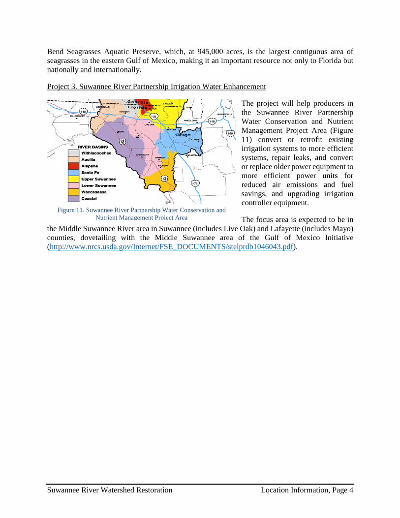
Project 3. Suwannee River Partnership Irrigation Water Enhancement
The project will help producers in the Suwannee River Partnership Water Conservation and Nutrient Management Project Area (Figure 11) convert or retrofit existing irrigation systems to more efficient systems, repair leaks, and convert or replace older power equipment to more efficient power units for reduced air emissions and fuel savings, and upgrading irrigation controller equipment.
The focus area is expected to be in the Middle Suwannee River area in Suwannee (includes Live Oak) and Lafayette (includes Mayo) counties, dovetailing with the Middle Suwannee area of the Gulf of Mexico Initiative (http://www.nrcs.usda.gov/Internet/FSE_DOCUMENTS/stelprdb1046043.pdf).
Figure 11. Suwannee River Partnership Water Conservation and Nutrient Management Project Area
Suwannee River Watershed Restoration Location Information, Page 4
High-Level Budget Narrative
Project Project Implementation
Project Contingency
Project Oversight
Project Administration
Total Funding
Requested 1. Restoring Resilience to Oyster Reefs in the Big Bend $4,428,801 $442,880 $177,152 $132,864 $5,181,697 2. Lower Suwannee River and Gulf Watershed Conservation Easement $4,000,000 $0 $0 $0 $4,000,000 3. Suwannee River Partnership Irrigation Water Enhancement Program $2,800,000 $0 $0 $84,000 $2,884,000
Proposal Proposal
Implementation Proposal
Contingency Proposal Oversight
Proposal Administration
Total Funding
Requested Suwannee River Restoration and
Preservation $11,228,801 $442,880 $177,152 $132,864 $12,065,697
Notes:
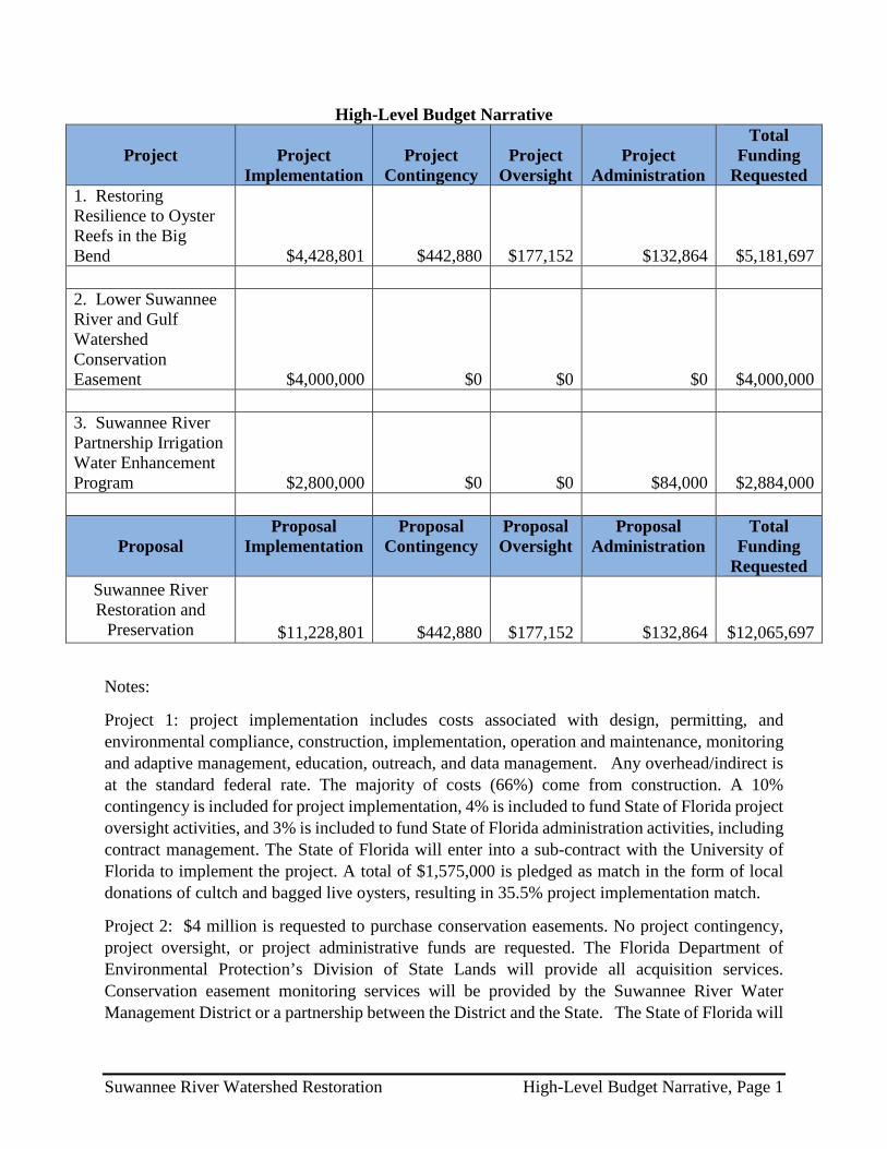
Project 1: project implementation includes costs associated with design, permitting, and environmental compliance, construction, implementation, operation and maintenance, monitoring and adaptive management, education, outreach, and data management. Any overhead/indirect is at the standard federal rate. The majority of costs (66%) come from construction. A 10% contingency is included for project implementation, 4% is included to fund State of Florida project oversight activities, and 3% is included to fund State of Florida administration activities, including contract management. The State of Florida will enter into a sub-contract with the University of Florida to implement the project. A total of $1,575,000 is pledged as match in the form of local donations of cultch and bagged live oysters, resulting in 35.5% project implementation match.
Project 2: $4 million is requested to purchase conservation easements. No project contingency, project oversight, or project administrative funds are requested. The Florida Department of Environmental Protection’s Division of State Lands will provide all acquisition services. Conservation easement monitoring services will be provided by the Suwannee River Water Management District or a partnership between the District and the State. The State of Florida will
Suwannee River Watershed Restoration High-Level Budget Narrative, Page 1

provide matching funds (estimated at $2 million) to acquire the 5,800 acre tract as noted in the proposal narrative.
Project 3: The project requests $2.8 million to supplement existing state and federal agricultural best management practices cost-share programs. The cost-share will be 75% for eligible practices, with producer contributing 25%. The Florida Department of Agriculture and Consumer Services (FDACS) will enter into contracts with local soil and water conservation district boards (Conservation Districts) to administer the cost-share funding program, and both will provide project monitoring services. No project contingency or project oversight funds are requested. Because of the cost share, the producers will be providing at least $700,000 in match. A 3% project administration amount to fund State of Florida administration activities is included because the FDEP will sub-contract with FDACS to implement this project.
Suwannee River Watershed Restoration High-Level Budget Narrative, Page 2
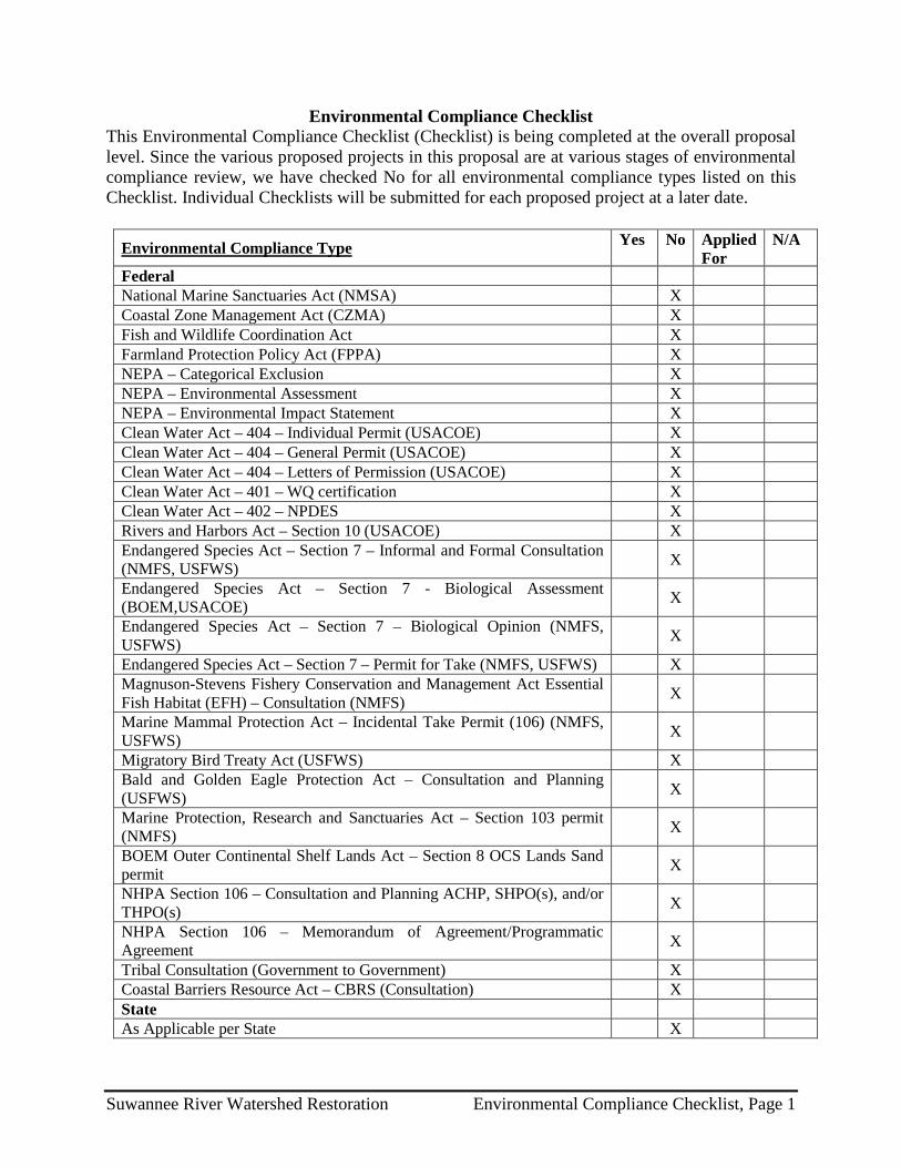
Environmental Compliance Checklist This Environmental Compliance Checklist (Checklist) is being completed at the overall proposal level. Since the various proposed projects in this proposal are at various stages of environmental compliance review, we have checked No for all environmental compliance types listed on this Checklist. Individual Checklists will be submitted for each proposed project at a later date.
Environmental Compliance Type Yes No Applied For
N/A
Federal National Marine Sanctuaries Act (NMSA) X Coastal Zone Management Act (CZMA) X Fish and Wildlife Coordination Act X Farmland Protection Policy Act (FPPA) X NEPA – Categorical Exclusion X NEPA – Environmental Assessment X NEPA – Environmental Impact Statement X Clean Water Act – 404 – Individual Permit (USACOE) X Clean Water Act – 404 – General Permit (USACOE) X Clean Water Act – 404 – Letters of Permission (USACOE) X Clean Water Act – 401 – WQ certification X Clean Water Act – 402 – NPDES X Rivers and Harbors Act – Section 10 (USACOE) X Endangered Species Act – Section 7 – Informal and Formal Consultation (NMFS, USFWS) X
Endangered Species Act – Section 7 - Biological Assessment (BOEM,USACOE) X
Endangered Species Act – Section 7 – Biological Opinion (NMFS, USFWS) X
Endangered Species Act – Section 7 – Permit for Take (NMFS, USFWS) X Magnuson-Stevens Fishery Conservation and Management Act Essential Fish Habitat (EFH) – Consultation (NMFS) X
Marine Mammal Protection Act – Incidental Take Permit (106) (NMFS, USFWS) X
Migratory Bird Treaty Act (USFWS) X Bald and Golden Eagle Protection Act – Consultation and Planning (USFWS) X
Marine Protection, Research and Sanctuaries Act – Section 103 permit (NMFS) X
BOEM Outer Continental Shelf Lands Act – Section 8 OCS Lands Sand permit X
NHPA Section 106 – Consultation and Planning ACHP, SHPO(s), and/or THPO(s) X
NHPA Section 106 – Memorandum of Agreement/Programmatic Agreement X
Tribal Consultation (Government to Government) X Coastal Barriers Resource Act – CBRS (Consultation) X State As Applicable per State X
Suwannee River Watershed Restoration Environmental Compliance Checklist, Page 1
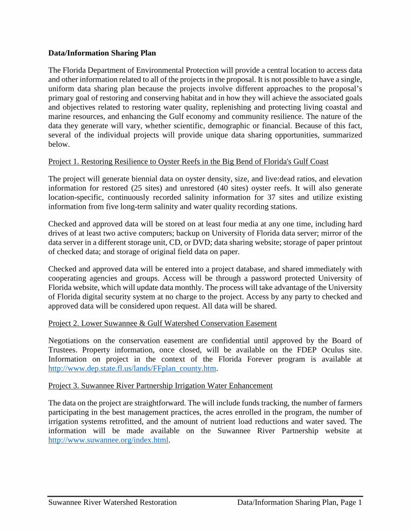
Data/Information Sharing Plan
The Florida Department of Environmental Protection will provide a central location to access data and other information related to all of the projects in the proposal. It is not possible to have a single, uniform data sharing plan because the projects involve different approaches to the proposal’s primary goal of restoring and conserving habitat and in how they will achieve the associated goals and objectives related to restoring water quality, replenishing and protecting living coastal and marine resources, and enhancing the Gulf economy and community resilience. The nature of the data they generate will vary, whether scientific, demographic or financial. Because of this fact, several of the individual projects will provide unique data sharing opportunities, summarized below.
Project 1. Restoring Resilience to Oyster Reefs in the Big Bend of Florida's Gulf Coast
The project will generate biennial data on oyster density, size, and live:dead ratios, and elevation information for restored (25 sites) and unrestored (40 sites) oyster reefs. It will also generate location-specific, continuously recorded salinity information for 37 sites and utilize existing information from five long-term salinity and water quality recording stations.
Checked and approved data will be stored on at least four media at any one time, including hard drives of at least two active computers; backup on University of Florida data server; mirror of the data server in a different storage unit, CD, or DVD; data sharing website; storage of paper printout of checked data; and storage of original field data on paper.
Checked and approved data will be entered into a project database, and shared immediately with cooperating agencies and groups. Access will be through a password protected University of Florida website, which will update data monthly. The process will take advantage of the University of Florida digital security system at no charge to the project. Access by any party to checked and approved data will be considered upon request. All data will be shared.
Project 2. Lower Suwannee & Gulf Watershed Conservation Easement
Negotiations on the conservation easement are confidential until approved by the Board of Trustees. Property information, once closed, will be available on the FDEP Oculus site. Information on project in the context of the Florida Forever program is available at http://www.dep.state.fl.us/lands/FFplan_county.htm.
Project 3. Suwannee River Partnership Irrigation Water Enhancement
The data on the project are straightforward. The will include funds tracking, the number of farmers participating in the best management practices, the acres enrolled in the program, the number of irrigation systems retrofitted, and the amount of nutrient load reductions and water saved. The information will be made available on the Suwannee River Partnership website at http://www.suwannee.org/index.html.
Suwannee River Watershed Restoration Data/Information Sharing Plan, Page 1

Reference List of Literature Cited
All projects: Gulf Coast Ecosystem Restoration Council. 2013. Restoring the Gulf Coast’s Ecosystem and Economy. 32 pp. http://www.restorethegulf.gov/
Baggett, L.P., S.P. Powers, R. Brumbaugh, L.D. Coen, B. DeAngelis, J. Green, B. Hancock, and S. Morlock, 2014. Oyster habitat restoration monitoring and assessment handbook. The Nature Conservancy, Arlington, VA, USA, 96pp.
Beck, M.W., R.D. Brumbaugh, L. Airoldi, A. Carranza, L.D. Coen, C. Crawford, O. Defeo, G.J. Edgar, B. Hancock, M.C. Kay, H.S. Lenihan, M.W. Luckenbach, C.L. Toropova, G.F. Zhang, and X.M. Guo. 2011. Oyster reefs at risk and recommendations for conservation, restoration, and management. Bioscience 61: 107-116.
Berrigan, M., T. Candies, J. Cirino, R. Dugas, C. Dyer, J. Gray, T. Herrington, W. Keithly, R. Leard, J.R. Nelson, and M. van Hoose. 1991. The oyster fishery of the Gulf of Mexico, United States: a regional management plan. Gulf States Marine Fisheries Commission. Ocean Springs, Mississippi.
Coen, L.D., R.D. Brumbaugh, D. Bushek, R. Grizzle, M.W. Luckenbach, M.H. Posey, S.P. Powers, and S.G. Tolley. 2007. Ecosystem services related to oyster restoration. Marine Ecology Progress Series 341: 303-307.
Florida Department of Agriculture and Consumer Services, Office of Agricultural Water Policy, http://www.freshfromflorida.com/Divisions-Offices/Agricultural-Water-Policy, particularly information on BMP implementation (http://www.freshfromflorida.com/Divisions-Offices/Agricultural-Water-Policy/BMP-Implementation), BMP Research (http://www.freshfromflorida.com/Divisions-Offices/Agricultural-Water-Policy/BMP-Research), and Evaluate Your Irrigation System (http://www.freshfromflorida.com/Divisions-Offices/Agricultural-Water-Policy/Evaluate-Your-Irrigation-System).
Florida Department of Environmental Protection. Division of State Lands, Tallahassee, FL, http://www.dep.state.fl.us/lands/.
Florida Department of Environmental Protection. Division of Environmental Assessment and Restoration, Tallahassee, FL, www.dep.state.fl.us/water/basin411/suwannee/index.htm.
Florida Forever land acquisition program, http://www.dep.state.fl.us/lands/fl_forever.htm.
Florida Institute of Agricultural Sciences, http://ifas.ufl.edu/.
Grinnell, Jr., R.S. 1972. Structure and development of oyster reefs on the Suwannee River delta, Florida. Ph.D. Dissertation, State University New York, Binghamton, New York.
Hine, A.C., D.F. Belknap, J.G. Hutton, E.B. Osking, and M.W. Evans. 1988. Recent geological history and modern sedimentary processes along an incipient, low-energy, epicontinental-sea coastline: Northwest Florida. Journal of Sedimentary Petrology 58:567–579.
Suwannee River Watershed Restoration Reference List of Literature Cited, Page 1

Petes, L.E., A.J. Brown, and C.R. Knight. 2012. Impacts of upstream drought and water withdrawals on the health and survival of downstream estuarine oyster populations. Ecology and Evolution 2(7): 1712-1724.
Rodriguez, A.B., F.J. Fodrie, J.T. Ridge, N.L. Lindquist, E.J. Theuerkauf, S.E. Coleman, J.H. Grabowski, M.C. Brodeur, R.K. Gittman,D.A. Keller, and M.D. Kenworthy. 2014. Oyster reefs can outpace sea-level rise. Nature Climate Change 4(6): 493-497.
Scyphers, S.B., S.P. Powers, K.L. Heck, Jr., and D. Byron. 2011. Oyster reefs as natural breakwaters mitigate shoreline loss and facilitate fisheries. PLoS ONE 6: e22396.
Seavey, J.R., W.E. Pine III, P. Frederick, L. Sturmer, and M. Berrigan. 2011. Decadal changes in oyster reefs in the Big Bend of Florida’s Gulf Coast. Ecosphere 2: 114.
Suwannee River Partnership, http://www.suwannee.org/index.html.
Walters, C.J. and S.J. Martell. 2004. Fisheries ecology and management. Princeton University Press.
Wright, E.E., A.C. Hine, S.L. Goodbred, and S.D. Locker. 2005. The effect of sea-level and climate change on the development of a mixed siliciclastic-carbonate, deltaic coastline: Suwannee River, Florida, USA. Journal of Sedimentary Research 75:621– 635.
Suwannee River Watershed Restoration Reference List of Literature Cited, Page 2

Other
As referenced in the narrative, the table below summarizes the Comprehensive Plan goals and objectives fulfilled by the projects in the Suwannee River Watershed Restoration proposal.
Comprehensive Plan Goal Proposal Contributions Comprehensive
Plan Objective Project Contributions
1. Restore and Conserve Habitat – Restore and conserve the health, diversity and resilience of key coastal, estuarine and marine habitats.
All three projects will contribute to the restoration and conservation of coastal ecosystem health, diversity, and resilience through restoration of oyster reefs, acquisition of conservation lands, and reduction of excessive nutrients degrade coastal waters.
1. Restore, Enhance, and Protect Habitats.
All three projects will contribute to the restoration and conservation of coastal ecosystem health, diversity, and resilience directly through habitat restoration and protection and improvement of water quality.
2. Restore Water Quality – Restore and protect water quality of the Gulf Coast region’s fresh, estuarine and marine waters.
Project 3 will directly improve water quality by reducing nutrients from agricultural discharges in the watershed; the hydrologic and habitat benefits of the other projects will also improve water quality.
2. Restore, Improve, and Protect Water Resources.
Project 3 will directly improve water quality by reducing nutrients from agricultural discharges in the watershed; the hydrologic and habitat benefits of the other projects will also improve water quality.
3. Replenish and Protect Living Coastal and Marine Resources – Restore and protect healthy, diverse and sustainable living coastal and marine resources.
Project 1 will directly restore oyster reefs. Water quality improvement and the acquisition of contiguous conservation lands that protect habitat and improve water quality will contribute directly to restoring and protecting coastal and marine resources.
3. Protect and Restore Living Coastal and Marine Resources.
Protection and restoration of water quality and coastal and wetland habitats will directly protect and restore living coastal resources.
4. Enhance Community Resilience – Build upon and sustain communities with capacity to adapt to short- and long-term changes.
Better water quality; restored wetland, floodplain, and coastal functions; and replenishment of living marine resources will enhance the resilience of the Big Bend ecosystems and the human communities that depend on them, making them more adaptable to change.
4. Restore and Enhance Natural Processes and Shorelines.
The projects improve water quality; restore wetland, floodplain, and coastal functions; and replenish living marine resources and natural coastal processes.
5. Restore and Revitalize the Gulf Economy – Enhance the sustainability and resiliency of the Gulf economy.
The Suwannee Watershed’s economy and quality of life are tied to ecosystem health and quality. Restoring and preserving water quality and living habitat will benefit the oyster harvesters, fisherman and the entire eco-tourist economy the area depends on.
5. Promote Community Resilience.
Better water quality; restored wetland, floodplain, and coastal functions; and replenishment of living marine resources and natural coastal processes directly promote community resilience in the Suwannee Watershed.
6. Promote Natural Resource Stewardship and Environmental Education.
Public engagement, education and outreach are fundamental components of all three projects and will contribute to long-term resource stewardship.
7. Improve Science-Based Decision-Making Processes.
Projects will use professionally accepted scientific methods and best management practices to assure quality project implementation and to expand on the existing knowledge base.
Suwannee River Watershed Restoration Other, Page 1

The following additional information helps to further characterize the importance of these projects to the Suwannee Watershed and to explain how they meet the goals, objectives, priority criteria, and commitments of the Restore Council.
Project 1. Restoring Resilience to Oyster Reefs in the Big Bend of Florida's Gulf Coast
The pictures of the Atsena Otie oyster reef (Figure 12), nearby Cedar Key, Florida, were taken two years after project construction. Note oysters growing through the recovered clam bags and American oystercatchers
foraging on Atsena Otie oyster reef. The project was built with oyster-encrusted clam bags and has shown successful growth over time and resiliency in the face of region-wide oyster mortality events.
The Big Bend project in the current proposal includes significant in-kind cost sharing. Cultch will be collected in the form of discarded clam and oyster shell from local shellfish processing plants and restaurants. It is expected to form the bulk of the cultch material and is being donated free to the project. High quality shell cultch is growing increasingly difficult to find and costs from $30 to $60 per cubic yard. At these rates, the expected contribution of locally collected cultch may be from $0.4 to $0.8 million.
Oyster-encrusted aquaculture bags are also donated by growers. These bags typically contain 8,000 live oysters
each, as well as associated epifauna. Counting the cost of the cultch within bags ($4.5/bag at a cost of $30/cubic yard of shell) and the cost of live oysters ($80/bag at a cost of $10/1000 oyster seed), these bags have been valued in prior federally funded projects at $85 per bag. With approximately 20,000 bags utilized in this project, the value of contribution is $1.69 million.
According to the Florida Fish and Wildlife Research Institute, the Big Bend Oyster Restoration project also offers a tremendous opportunity to complement its ongoing oystercatcher project (“American Oystercatcher Habitat Restoration in Florida”). The birds already demonstrate a strong positive response to the recent oyster reef restoration efforts. The extent of the proposed Big Bend work is expected to substantially improve the ability to predict avian responses to future reef restorations. It will also help address how restoration influences population trends at scales relevant to statewide and national conservation efforts. The avian research leader at the Institute judges the project’s probably of success with respect to birds as high, and the degree to which that is the case it will go a long way in helping design similar projects in the future.
Letters of Support
See attached letters of support from commissioners of Levy and Dixie counties, Cedar Key Aquaculture Association, Cedar Key Oysterman’s Association.
Figure 12. Atsena Otie oyster reef restoration
Suwannee River Watershed Restoration Other, Page 2

Suwannee River Watershed Restoration Other, Page 3

Suwannee River Watershed Restoration Other, Page 4

Suwannee River Watershed Restoration Other, Page 5

Suwannee River Watershed Restoration Other, Page 6
Suwannee River Watershed Restoration Other, Page 7

Project 2. Lower Suwannee & Gulf Watershed Conservation Easement
Suwannee River Watershed Restoration Other, Page 8
Suwannee River Watershed Restoration Other, Page 9
Project 3. Suwannee River Partnership Irrigation Water Enhancement
In addition to the water resource, water conservation and habitat protection benefits of the irrigation retrofits implemented through this project, air emissions can be significantly reduced by upgrading the power plants for irrigation motors. Given today's energy costs, tremendous economic and resource savings can result, lending to the sustainability of agriculture in the Suwannee Basin. Based on USDA-NRCS energy calculators and information from private engineers, converted systems will reduce energy use by 40%. Water use permits require that producers be as efficient as possible when irrigating crops, and low-pressure systems are strongly recommended to ensure maximum efficiency in applying irrigation water. The estimated 40% reduction in energy use will result in an approximate reduction of 2.1 tons of NOx associated with crop irrigation.
Suwannee River Watershed Restoration Other, Page 10

PROPOSAL TITLE PROPOSAL NUMBER
LOCATION
SPONSOR(S)
TYPE OF FUNDING REQUESTED (Planning, Technical Assistance, Implementation)
REVIEWED BY: DATE:
Suwannee River Watershed Restoration FL-3
Suwannee River Watershed within Florida
Florida
Planning/Technical Assistance/Implementation
Bethany Carl Kraft/ Ben Scaggs 11-18-14

1. Does the project aim to restore and/or protect natural resources, ecosystems, fisheries, marine and wildlife habitat, beaches, coastal wetlands and economy of the Gulf Coast Region?
YES NO
Notes:
2. Is the proposal a project?
YES NO
If yes, is the proposed activity a discrete project or group of projects where the full scope of the restoration or protection activity has been defined?
YES NO
Notes:
Proposal seeks funding for projects that, collectively, will restore and protect habitat and water resources; replenish livingmarine resources; and revitalize the local economy.

3. Is the proposal a program?
YES NO
If yes, does the proposed activity establish a program where the program manager will solicit, evaluate, select, and carry out discrete projects that best meet the program's restoration objectives and evaluation criteria?
YES NO
Notes:
4. Is the project within the Gulf Coast Region of the respective Gulf States?
YES NO
If no, do project benefits accrue in the Gulf Coast Region?
YES NO
Notes:

Eligibility Determination
Additional Information
Proposal Submission Requirements
1. Is the project submission overall layout complete? Check if included and formatted correctly.
A. Summary sheet F. Environmental compliance checklist
B. Executive summary G. Data/Information sharing plan
C. Proposal narrative H. Reference list
D. Location information I. Other
E. High level budget narrative
If any items are NOT included - please list and provide details
ELIGIBLE
✔ ✔
✔ ✔
✔ ✔
✔ ✔
✔

2. Are all proposal components presented within the specified page limits (if applicable)?
YES NO
Notes: