Embed Size (px)
Citation preview

Corporate NO: __________
Report COUNCIL DATE: __________
REGULAR COUNCIL
TO: Mayor & Council DATE: September 26, 2005
FROM: General Manager, Planning and Development FILE: 6520-20 (South Port Kells)
SUBJECT: South Port Kells General Land Use Plan – Bothwell Drive Neighbourhood Delegation to Council from Ms. Jennifer Chen
RECOMMENDATION
It is recommended that Council:
1. Receive this report as information; and 2. Instruct the City Clerk to forward a copy of this report and Council’s resolution,
related to this report, to Ms. Jennifer Chen, representative of residents in the Bothwell Drive area of South Port Kells.
INTENT
The purpose of this report is to respond to questions raised at the July 25, 2005, Council-in-Committee meeting by Ms. Jennifer Chen, on behalf of residents of Bothwell Drive, regarding the provisions of the South Port Kells General Land Use Plan related to the properties in the vicinity of Bothwell Drive.
BACKGROUND
On June 13, 2005, Council ratified the May 30, 2005 Council-in-Committee decision to approve the South Port Kells General Land Use Plan (attached as Appendix I to this report) as the basis for preparing Neighbourhood Concept Plans ("NCP"s) for the community of South Port Kells. The General Land Use Plan identifies three major neighbourhood areas, Anniedale, Tynehead and Port Kells, for the purpose of preparing detailed NCPs.

- 2 -
On July 25, 2005, Council received a delegation from Ms. Jennifer Chen, on behalf of 13 properties in the west Tynehead area. The delegation requested an amendment to the General Land Use Plan to increase the density proposed for lands along Bothwell Drive and to request that the Tynehead area proceed to the NCP planning stage in the immediate future.
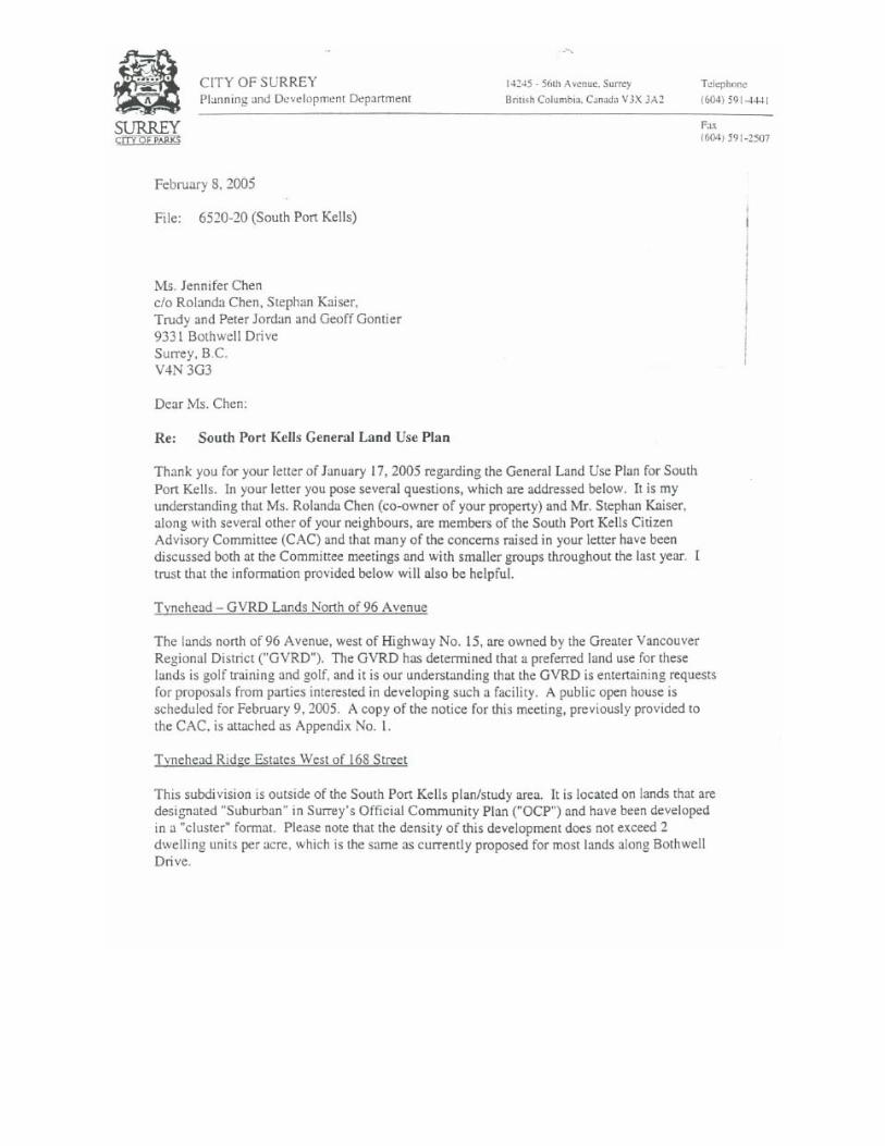
Prior to the July 25, 2005 appearance before Council-in-Committee, the delegation had submitted a series of letters to the Planning and Development Department, requesting an expedited NCP process for the Tynehead area, higher density land use designations for their neighbourhood, a reduction in the width of the Agricultural Land Reserve ("ALR") buffer in Tynehead, engineering servicing options, the validity of watercourse classifications and the classification of environmentally sensitive areas. The specific area to which the delegation’s requests relate, is shown on the map attached as Appendix II to this report. Staff responded in writing to each of the letters (attached as Appendix III to this report) and held meetings with the group on three occasions (May 28, 2004, September 23, 2004 and June 1, 2005) to discuss the group’s concerns, issues and inquiries, and to explain the environmental, servicing and development constraints in Tynehead, which limit the potential density of development and the timing of an NCP process for the area.
DISCUSSION
At the July 25, 2005 presentation to Council, the delegation provided a handout (attached as Appendix IV to this report), outlining three issues of concern in relation to the densities in the subject area: waterways, the ALR buffer and setbacks. Council requested that staff use the handout as the basis for preparing a report back to Council.
Watercourses The delegation advised Council that watercourse sensitivity in the Tynehead area has not been confirmed by a physical assessment of all watercourses in the area. The delegation advised that the presence of watercourses was based on aerial photographs and that all potential watercourses should be ground-truthed by the City of Surrey to confirm their sensitivity. The delegation further requested that if the potential watercourses are found to be less sensitive than originally evaluated, the South Port Kells General Land Use Plan should be amended to provide for a higher density designation. A complete ground inspection of all watercourses is not performed in preparing a General Land Use Plan, such as the one recently completed for South Port Kells. The process of a more detailed investigation (ground-truthing) of all watercourses in the Tynehead area will be performed at the NCP planning stage and an even more detailed review will be undertaken at the time of development application review on a site-by-site basis. This is the process that the City has followed for communities throughout the City over the last several years. For the purposes of the South Port Kells General Land Use Plan, an environmental assessment of the South Port Kells area was undertaken by a qualified environmental consultant (Phoenix Environmental Services Ltd.). The consultant examined the City’s
- 3 -
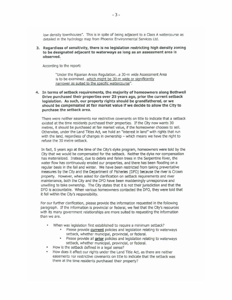
stream (fish) classification maps (which are developed from aerial photographs), contour mapping interpretation, and some field inspections. The stream classification maps serve as a general guideline/reference tool for determining stream sensitivity. Although watercourses identified from aerial photographs are not absolute, staff has found the photographs to be a reasonable gauge of watercourses throughout the City. The consultant’s report identified, in the Tynehead area, the Class "A" Serpentine River creek system between 96 Avenue, 172 Street, 92 Avenue and 168 Street. The City of Surrey’s Fisheries Watercourse Classification system, which is used to classify the potential presence of fish and fish nutrients, identifies Class "A" watercourses as watercourses that are inhabited year-round by salmonids (salmon, trout) or have potential to be inhabited year-round by salmonids. In response to this classification for the subject creek, the General Land Use Plan identifies that a lower density form of residential development would be appropriate for this area. This area has been treated in the same manner as the lands surrounding the Latimer Creek headwaters in the eastern section of the South Port Kells General Land Use Plan. The City will retain a professional environmental consultant to perform a detailed review of the watercourses and other environmental features of the Tynehead area at the NCP planning stage. Staff, however, is relatively confident that the stream classifications in this area are reasonable and a significant change to the classification of the stream is not expected at the NCP planning stage.
ALR Buffer The delegation noted that the ALR lands adjacent to Tynehead, south of 92 Avenue, between 168 Street and 176 Street, have not been actively farmed in the last 30 years, and that the extent of protection of the ALR should depend on the extent to which the land is being farmed. It was suggested that a physical assessment of the ALR lands south of 92 Avenue be performed to evaluate their agricultural sensitivity and that the size of the ALR land buffer on the General Land Use Plan should change if the lands are found to be less sensitive than previously thought. It was also noted that the ALR buffer for this portion of Tynehead (between 168 Street and 176 Street) appears larger than the ALR buffer between 180 Street and 184 Street in the General Land Use Plan. Council Policy O-23 stipulates that within the transition area of a minimum of one-quarter mile in depth away from the ALR boundary, development should occur at suburban densities (i.e., a maximum density of two units per acre) and where possible, this transition should be extended to one-half mile. In some areas covered by the South Port Kells General Land Use Plan primarily involving lands on steep slopes with substantial vegetation (e.g. between 180 and 184 Streets), clustered development is proposed within the one-quarter mile buffer area adjacent to the ALR, subject to substantial buffer areas being retained immediately adjacent to the ALR boundary where no development at all will take place. This will provide for a different form of development that respects the overall densities anticipated by Council Policy O-23.
- 4 -
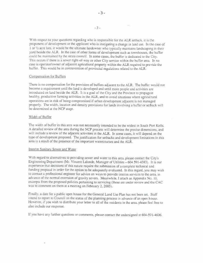
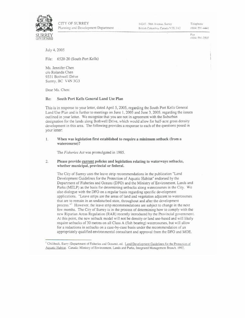
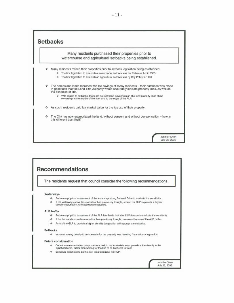
Setbacks The delegation commented that riparian and ALR setback requirements are restrictive and reduce property values in Tynehead, which may have been increased with a higher density designation. Compensation for property loss resulting from setback legislation was requested, noting that many residents purchased their properties prior to the establishment of watercourse and agricultural setback legislation. The delegation noted that the properties represent the life savings of many property owners in Tynehead. Riparian setback requirements exist under Provincial and Federal legislation. Although the Federal Fisheries Act was not adopted until 1985, prior to that date Federal Fisheries Officers often recommended setbacks and fish habitat protection in riparian areas. The intent of the Federal Fisheries Act is to prohibit the "harmful alteration, disruption, or destruction" of fish habitat. The Land Development Guidelines, developed by the Department of Fisheries and Oceans ("DFO") and used by the City, outline a setback model that, if adhered to, provides reasonable assurance that land development projects comply with the Fisheries Act. DFO's fish protection policy led to the creation of the Provincial Streamside Protection Regulation and now to the new Riparian Areas Regulation ("RAR") that has been developed by Provincial and Federal environment officials. Currently, the City uses the Land Development Guidelines, but is exploring use of the new RAR. The RAR would require a 30-metre setback along all vegetated Class A watercourses, which could be reduced on a case-by-case basis, based on the recommendations of a qualified environmental professional. Under the RAR, this evaluation process will take place at the time of consideration of a development application for a site along a Class A watercourse. Riparian area setback designations are the responsibility of the Provincial and Federal governments. Any relaxations or variances must be approved by officials of these senior levels of government. Lands contained within a riparian area setback within a lot can, in most circumstances, be used in the calculation of overall gross density of development allowed on the lot. "Grandfathering" does not apply to the application of fisheries-related setbacks and other fisheries-related requirements established by the Provincial and Federal governments, regardless of the duration of property ownership.
There is no compensation for the provision of buffers adjacent to the ALR or required riparian setbacks along creeks and streams. It is a goal of the City and the Province to propagate healthy, productive farming activities in the ALR, and to avoid situations where agricultural operations are in risk of being compromised if urban development adjacent to the ALR is not managed properly. The width and design of buffers and riparian setbacks and final density provisions will be determined at the NCP planning stage.

- 5 -
Timing of an NCP for the Tynehead Area Under "Future Considerations" in the presentation to Council, the delegation requested: • Once the main sanitation pump station is built in the Anniedale area, provide a
line directly to the Tynehead area, rather than waiting for the line to be built east to west; and
• Schedule Tynehead to be the next area to receive an NCP. As the approved South Port Kells General Land Use Plan notes, there is currently no sewer capacity available for the South Port Kells area. Urban development cannot occur until the North Surrey Interceptor is constructed by the Greater Vancouver Sewer and Drainage District, (GVS&DD) generally along the future alignment of the South Fraser Perimeter Road to about 176 Street and 104 Avenue. This interceptor is not expected to be constructed until at least 2007. Once this trunk sewer is extended south across Highway No. 1 into South Port Kells, the trunk sewer mains within South Port Kells, including the Tynehead area, would normally be constructed sequentially to provide for gravity flow as far as possible. At this time, it is anticipated that Anniedale Areas "A" and "B" and the Port Kells areas would be serviced with sanitary sewer first, with the sewer main then looping towards the west to service the Tynehead area (see map attached as Appendix V to this report). This sequence/phasing of sanitary sewer servicing follows the General Land Use Plan’s intent of maximizing areas serviced by gravity sewer and minimizing pumping costs. Based on the normal extension of gravity sewer systems, the Tynehead area would be the last of the South Port Kells neighbourhood areas to receive sanitary sewer servicing. Interim servicing strategies may be considered at the owners'/developers' expense, as long as ultimate servicing is not encumbered or delayed as a result.
NCPs are prepared and development is managed, based on the feasibility of providing engineering servicing, including transportation management, and on the property owners’/developers’ ability to demonstrate that the "front-end" costs of development can be managed. Should proponents of development in the Tynehead neighbourhood wish to advance the servicing of the Tynehead community through the construction of a pump station and forcemain, this would need to be undertaken at the cost of the proponents, as this would be an interim servicing scheme.
General Comments Regarding Land Use Designations for the Tynehead Area The approved South Port Kells General Land Use Plan is intended to act as a guide for the development of neighbourhood specific NCPs in the South Port Kells area. The land use designations, as proposed in the General Land Use Plan, are not "cast in stone". They can be revisited as part of any NCP planning process and changes could be considered at that time, where planning rationale supports such changes. The more detailed information that is compiled through the NCP planning process will assist in establishing whether any changes to the land use designations are appropriate.

- 6 -
Community Involvement in the General Land Use Planning Process
The South Port Kells General Land Use Plan is a culmination of one and one-half years of planning and community consultation process, with 11 Citizens Advisory Committee ("CAC") meetings and four open houses. The General Land Use Plan as approved by Council, including the proposed designation of the Bothwell Drive area, had the overall support of the CAC.
CONCLUSION
It is recommended that Council instruct the City Clerk to forward a copy of this report and Council’s resolution, related to this report, to the delegation that appeared before Council on behalf of some residents in the Bothwell Drive area of South Port Kells.
Murray Dinwoodie General Manager Planning and Development
FW/kms/saw Attachments Appendix I South Port Kells General Land Use Plan Appendix II Map of the Tynehead area of South Port Kells identifying lands represented
by the delegation Appendix III Correspondence between the delegation and the City Appendix IV Submission by the delegation presented at the July 25, 2005 CIC Meeting Appendix V Conceptual Servicing Map for South Port Kells v:\wp-docs\admin & policy\05data\july-sept\09231138.fw.doc SAW 10/7/05 9:52 AM
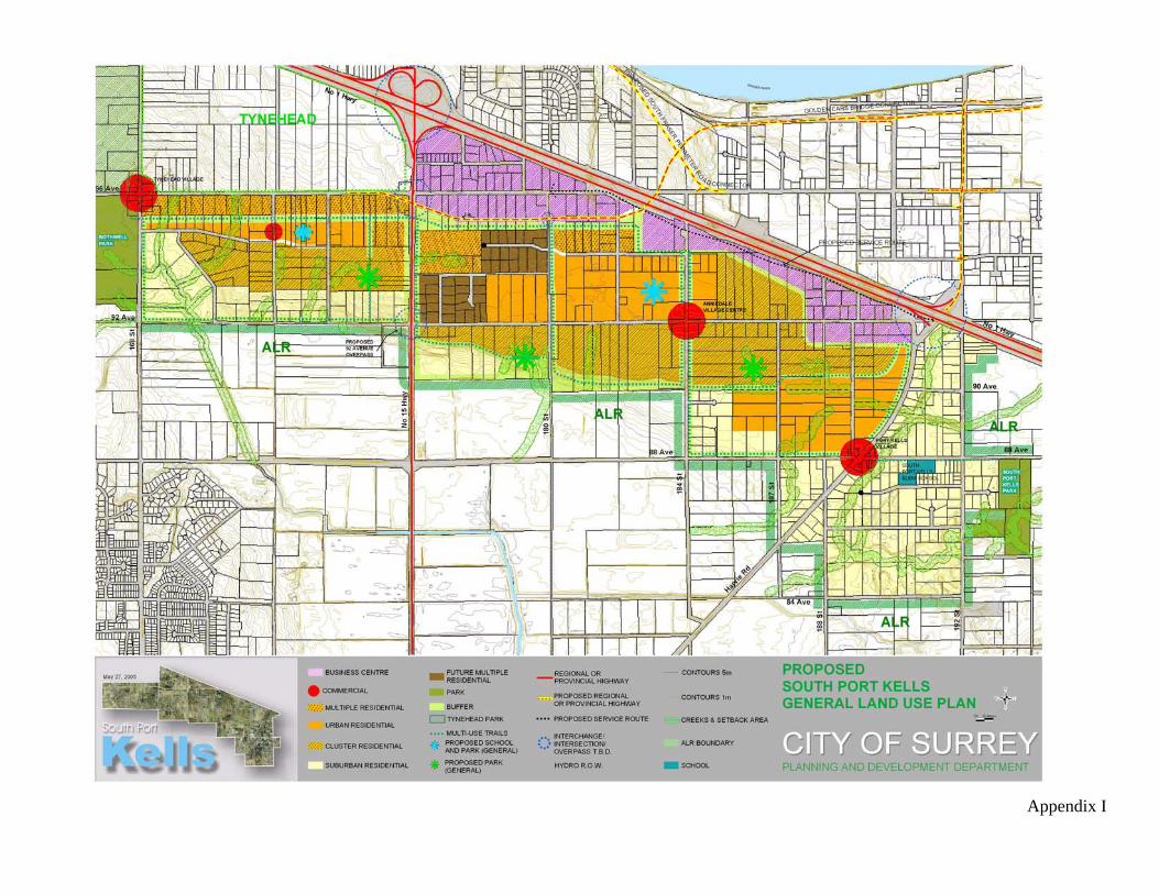
Appendix I

Appendix II
Map of the Tynehead Area of South Port Kells Identifying Lands Represented by the Delegation
Shaded Area Indicates Lands Represented by the Delegation

Appendix III

- 2 -

- 3 -

- 2 -
- 3 -

- 4 -


- 2 -
- 3 -

- 4 -

- 5 -


- 2 -


- 2 -

- 2 -

- 3 -

- 4 -

Appendix IV

- 2 -

- 3 -

- 4 -

- 5 -

- 6 -

- 7 -

- 8 -

- 9 -

- 10 -
- 11 -

Appendix V
v:\wp-docs\admin & policy\05data\july-sept\09231138.fw.doc SAW 10/7/05 9:52 AM