Embed Size (px)
Citation preview

Trans. geol. Soc. S. Afr., 83 (1980), 5-16
CONTINUATION OF THE PAN AFRICAN DAMARA BELT INTO ANGOLA: A PROPOSED CORRELA TION OF THE CHELA GROUP IN SOUTHERN ANGOLA WITH THE NOSIB
GROUP IN NORTHERN NAMIBIA/SW A
by
A. KRONER and H. CORREIA
ABSTRACT The Pan African Damara orogenic belt continues from north-western Namibia across the Kunene
River into south-western Angola. Its northern margin is characterized by miogeosynclinal rock assemblages of the Damara Supergroup which were deposited in late Precambrian times along the margin of the Congo Craton and which rest unconformably on ca. 1 060 Ma old or older basement.
The Nosib Group constitutes the basal sequence of the Damara Supergroup in northern Namibia and its lithology, stratigraphy and depositional environment are described from five selected areas surrounding the Etosha basin. These rocks as well as the overlying strata of the Otavi and Mulden groups can be followed from the Baines Mountains of the Kaokoveld into the Tchamalindi Mountains of southern Angola. In view of the excellent lithostratigraphic correlations we propose to include the Tchamalindi sequence into the Damara Supergroup and to adopt the nomenclature introduced in Namibia for the equivalent strata, at least at subgroup and group level.
Rocks of the Chela Group and overlying Leba Formation constitute mixed sedimentary-volcaniclastic platform deposits which are exposed in four areas of south-western Angola. The lithology, stratigraphy and age of these strata are reviewed on the basis of detailed work in the Humpata Plateau near Sa da Bandeira and we propose a correlation with the Nosib and Otavi groups of northern Namibia.
Our proposed ocrrelations imply that the Damara belt extends well into south-western Angola, perhaps as far as Porto Alexandre, and that the Chela Group was deposited in a stable cratonic environment east of the area affected by Pan African tectono-ther,mal activity.
CONTENTS Page I. INTRODUCTION ...... , ............................................................. 5
II. THE NOSIB GROUP IN NORTHERN NAMIBIA ...................................... 7 A. Otavi Mountains and Area South of Grootfontein .................................... 7 B. Khorixas (Welwitschia) Area and Summas Mountains ............. , .................. , 7 C. Kowares Region .................................................................. 9 D, North-eastern Kaokoveld Between Ruacana and West of Ohopoho ..................... 9 E. North-western Kaokoveld (Baines and Otjihipa Mountains) ............................ 9 F Depositional Environment .................... , , ................................... 10
III. THE DAMARA SEDIMENTS IN THE IONA-ESPINHEIRA AREA OF SOUTHERN ANGOLA, .. , .. , ... , .................................................... 10 A. The Area South of lona (Tchamalindi Mountains) .................................... 10 B. The Area South and North of Espinheira ............................................ 12
IV. THE CHELA GROUP OF THE HUMPATA PLATEAU REGION ....................... 12 A. Tundavala Formation ..................................... " ...................... 13 B. Humpata Formation .............................................................. 13 C. Bruco Formation ................................................................. 14 D. Cangalongue Formation ........................................................... 14 E. Leba Formation, ................... , ..... , ....................................... 14
V. CORRELATION, AGE AND PALAEOMAGNETISM .................................. 14 VI. CONCLUSIONS ................................. , ... , ................................ 15
ACKNOWLEDGMENTS .............................................................. 16 REFERENCES ....................................................................... 16
I. INTRODUCTION The Pan African Damara orogenic belt of south-west
ern Africa consists of two branches, one trending in a nearly 400 km wide zone across the central and northern part of Namibia, the other following the Atlantic coastline from Namibia into southern Angola (Fig. 1). The precise relationships between these two branches are still open to considerable debate and it has been suggested that the geometrical configuration resembles that of a triple junction (Kroner, 1977a; Martin and Porada, 1977).
The northern margin of the Damara belt in Namibia is occupied by a miogeosynclinal assemblage which is exposed from Grootfontein and Tsumeb in the east via the Otavi Mountains to the Kamanjab region, where the general east-west strike changes gently in a wide arc to north-north-west into the eastern Kaokoveld and into the lona region of southern Angola (Fig. 1). In this way the miogeosynclinal succession forms a broad basin with its centre in the Etosha basin of Ovamboland.
The stratigraphic sequence in northern Namibia consists of the basal Nosib Group (Hedberg, 1975) (previously Nosib beds, Stahl, 1926; Nosib Formation, Martin, 1965, and Hundskopf Formation, Stahl, 1940), followed conformably or unconformably by the Otavi Group (previously Otavi Facies of the Damara System, Martin, 1965, or Outjo Facies of the Otavi System, Clifford, 1967) and the Mulden Group (previously Mulden Formation, Martin, 1965). All these units are now part of the Damara Supergroup and reflect various stages in the geotectonic evolution of the Damara orogenic belt. The present lithostratigraphic nomenclature in the Damara belt is given in Table I.
The Nosib Group rocks represent the basal unit of the Pan African sequence and rest unconformably on considerably older gneisses and granitoid rocks that constitute the south-western margin of the Congo Craton. They can be followed from the low grade miogeosynclinal realm into the high grade central zone of the Damara belt (Martin, 1965) and are also recognized along the highly
Rep
rodu
ced
by S
abin
et G
atew
ay u
nder
lice
nce
gran
ted
by th
e Pu
blis
her (
date
d 20
10)

6 TRANSACTIONS OF THE GEOLOGICAL SOCIETY OF SOUTH AFRICA
A n 9 o a
Ruacana Falls ._._._._._._._._._._._._._._._._._._._._._._._._._._.-. c-..,:oar:;;;;..-r..
,-, , ' , , , , , , ,
. '\ .
"
I
\ , , N a mi b a ( South West Africa)
. >'\, \l1\G:e __ o_u~~r-o_~_, . '>---:-----·---- _______ -',~ep!?~J~~~~}~~~~;~~_s:~/ . . .',
o 50 100km ==-~:::::::.-
D Younger cover
1\./'1 ~osib & Swak~p Groups In eugeosyncline
D Otavi & Mulden Groups in miogeocline
_ Nosib Group
rn Pre Damara Basement
Figure 1 Simplified map of the northern margin of the Damara belt in Namibia showing distribution of major outcrops of Nosib Group rocks and the approximate boundary between the miogeosynclinal and eugeosynclinal facies of the Damara Supergroup. 1 =. Otavi Mountains and Grootfontein area, 2 = Khorixas (Welwitschia) area and Summas Mountains. 3 = Kowares region, 4 = north-eastern Kaokoveld (Ruacana-Ohopoho-Giraffenberge-Steilrandberge),5 = north-western Kaokoveld (Baines and Otjihipa Mountains).
tectonized southern margin of the orogen (Schalk, 1972). Towards the north, beyond the Kunene River in south
ern Angola, correlations have so far been less certain (Torquato, 1971), mainly because only few people have seen the Damaran strata in both territories and detailed mapping in the critical areas of the Baines Mountains and the hills south of lona has never been completed in detail.
Beetz (1933) first observed several occurrences of flatlying sedimentary sequences in south-western Angola between the Humpata Plateau south of Sa da Bandeira and the Kunene River. To these he gave the name Chela Formation and considered them to be of lower Palaeozoic age. Mouta (1951) renamed these strata into Chela Series
and correlated them with the Bembe System of northwestern Angola, now incorporated in the West Congo System (Stanton et al., 1963) or West Congo Supergroup (Cahen, 1978). Vale (1971, 1973a, b) mapped the Chela occurrences in the Humpata Plateau and also regarded these rocks as an essentially sedimentary sequence of early Palaeozoic age. A more detailed and revised stratigraphy was proposed by Correia (1976) and these data are discussed in this paper.
The Chela sediments of Beetz (1933) in the area south and south-east of lona north of the Kunene River were mapped by Messrs. Longyear Company in 1955 and are shown on the official geological map of Angola, 1 : 250 000, sheet lona (1961). Again a Palaeozoic age
TABLE I Lithostratigraphic Subdivision of the Damara Supergroup in the Northern (Miogeoclinal) Domain of the Damara Belt.
Old nomenclature of Damara System (Outjo System of Clifford et al., Proposed new nomenclature for Damara Supergroup 1962) in northern and transitional area of Damara Belt (Martin, 1965) in northern and transitional areas (SACS- Pre-Cape
Working Group)
Series Facies or Stage Substage Group Subgroup Formation
Formation MULDENI KHOMAS MULDEN SERIES
Unconformity Unconformity Outjo (Otavi of Clifford Tsumeb ~ Tsumeb et al., OTAVI OTAVI 1962) SERIES Tillite Chuos
Discordance Discordance Abenab Abenab Unconformity Unconformity
NOSIB NOSIB FORMATION
Major Unconformity Major Unconformity
Rep
rodu
ced
by S
abin
et G
atew
ay u
nder
lice
nce
gran
ted
by th
e Pu
blis
her (
date
d 20
10)

CORRELATION OF DAMARA BELT IN ANGOLA AND NAMIBIA/SW A 7
was suggested and Longyear proposed a correlation of their Series "A" with what is presently known as the Otavi Group of the Damara Supergroup in Namibia.
Subsequent reports resulted in considerable confusion as to the age and correlation of the Chela sequence. Torquato (1971) correlated strongly deformed chlorite and sericite schists north of lona with the Nosib "Formation" of Namibia and suggested that the overlying unfolded Chela quartzites correspond to the Outjo Facies of the Damara belt. De Villiers (1972) supported this suggestion and furthermore proposed to equate the Chela sequence with the Mulden (i.e. uppermost Damara) Formation and Nama Group (pers. comm., 1972) of Namibia.
Carvalho (1972) was the first to suggest a late Precambrian age for the Chela on account of a K-Ar whole rock age of 777 ± 41 Ma for a noritic dyke cutting the sediments south of the Humpata Plateau near Sa da Bandeira (Torquato and Amaral, 1973). He further correlated the quartzites of the lower Chela with the Nosib sequence and the upper Chela carbonates with those of the Otavi Group. An upper age limit for the Chela was given by Rb-Sr biotite ages of 1 023-1 040 ± 60 Ma for granites in the pre-Chela basement (Mendes, 1968, cited in Carvalho, 1972). Torquato and Amaral (1973) further dated a granodiorite associated with the post-Chela norite dykes at 800 ± 13 Ma (K-Ar whole rock) and considered this to be the minimum age for the Chela strata. Later Torquato (1974) suggested the Chela age to be in excess of 1 488 Ma on account of a conventional age calculation for an apparently intrusive granite, based on one single whole rock measurement. He also dated another noritic dyke, in his view cutting the Chela near the village Vila Arriaga, at 1 481 ± 39 Ma (K-Ar, whole rock). If these ages and the inferred intrusive relationship are correct the correlation proposed by Carvalho (1972) must be erroneous since the Nosib of Namibia is known to be younger than about 1 000 Ma (Kroner, 1977b).
In this paper we present strong stratigraphic and palaeomagnetic evidence supporting the Nosib-Chela correlation and we also reinterpret previous data and suggest that the Pan African Damara belt continues into south-western Angola as far as Porto Alexandre.
II. THE NOSIB GROUP IN NORTHERN NAMIBIA Rocks now included in the Nosib Group occur in a
broad zone of the northern miogeosynclinal domain of the Damara belt extending from the Okavango River in the Caprivi Strip to the Kunene River and beyond (Fig. 1). The main outcrop areas are the Otavi Mountains and environs near the towns of Tsumeb, Otavi and Grootfontein, the Khorixas (formerly Welwitschia) area of Damaraland, the area around Kowares along the north-western margin of the Fransfontein basement inlier in the Kaokoveld, and the extensive occurrences in the northern Kaokoveld west of Opuwa (formerly Ohopoho) in the Steilrandberge and Giraffenberge, south of the Kunene Basic Complex and in the Baines Mountains.
The term Nosib Group was proposed by Hedberg (1975) for the dominantly clastic rocks that accumulated during the first stages of Damaran geosynclinal evolution and overlie the older metamorphic or granitoid basement with a profound unconformity. Although the succession consists largely of sandstones, quartzites and conglomerates, considerable variations are encountered in detail, including such rock types as phyllite, carbonate, mixtite as well as a variety of volcanic flows and pyroclastics. The latter are particularly prominent in the southern areas near the transition to the eugeosynclinal domain of the Damara belt.
A slight angular unconformity usually separates the Nosib from the overlying carbonates of the Abenab Subgroup (Otavi Group), but in some areas the contact is
transitional. Near Welwitschia the lower Nosib strata are intruded by the Oas Syenite whereas the carbonates of the Otavi Group rest unconformably on this igneous complex (Frets, 1969). This relationship may support a significant hiatus between the two units; on the other hand, Miller (1972, 1974) found acid volcanic flows intercalated with Damaran carbonates and the Chuos mixtite and concluded that Nosib felsic volcanicity continued from Nosib into Otavi/Swakop times.
The stratigraphy and lithology of the Nosib around the Etosha basin was recently described in considerable detail by Hedberg (1975). Further descriptions are by Frets (1969) for the Welwitschia area, Guj (1970) for the southwestern Kaokoveld and Schalk (pers. comm., 1975) for the north-western Kaokoveld. The following brief account summarizes these data, including own observations, and a schematic comparison of the stratigraphic units and their interrelationships is given in Fig. 2 after Hedberg (1975).
A. Otavi Mountains and Area South of Grootfontein The base of the Nosib is a conglomerate of extremely
variable thickness (O--~ 100 metres) with basement and quartzite cobbles set in a matrix of feldspathic grit. To the west this rock is increasingly replaced by sandstone with scattered lenses of conglomerate and sandstone with a general upward reduction in coarseness, and intercalations of shale and graywacke also occur in the higher portion of the sequence. Hedberg (1975) also noted an upward increase in the iron oxide content and found a noticeable amount of rock fragments, including shale, siltstone and volcanics. The upper Nosib is again clastic and consists of poorly sorted ferruginous arkose, graywacke, sandstone and siltstone. A considerable percentage of andesite fragments suggests a tuffaceous origin for some of these beds which may be contemporaneous with the epidosite lavas and pyroclastics to the south (Fig. 2).
South of the Otavi Mountains the basal Nosib consists of conglomerate and quartzite, followed by about 45 metres of thinly bedded sericitic dolomite (Nab is Formation). The upper part of the sequence (Askevold Formation) comprises some 300 metres of epidotized amygdaloidal andesite lava flows interbedded with tuff and agglomerate.
Hedberg (1975) estimates a maximum thickness of 1 200 metres in the Otavi Mountains and suggested deposition in an intermontane basin or basins with irregular relief.
B. Khorixas (Welwitschia) Area and Sum mas Mountains The Nosib Group rocks are exposed on the southern
flank of the Fransfontein basement inlier (Fig. 1) and consist of the lower sedimentary Austerlitz Formation and the upper almost exclusively volcanogenic Naauwpoort Formation (Frets, 1969; new nomenclature after Hedberg, 1975; see also Fig. 2). The Austerlitz strata are up to 2500 metres thick and consist of conglomerate, quartzite, graywacke and thin lenses of dolomite at the top. They are overlain conformably by up to 1 200 metres of volcanic flows and tuffs and thin intercalated beds of graywacke and carbonate rock (Fig. 2). The volcanics consist of porphyritic trachyandesite and andesite and a variety of acid differentiates including flow-laminated feldspar rhyolite, vitreoclastic flows and welded tuffs, and felsic crystal tuff.
On the farm Oas 486, Damaraland, the Austerlitz quartzites were intruded by the Oas Syenite for which a 7-point Rb-Sr whole rock isochron indicates an emplacement age of 840 ± 12 Ma (Kroner" 1980). Since Frets (1969) considered the syenite to represent the intrusive equivalent of the Naauwpoort volcanics the above date may be regarded as a minimum age for the Nosib Group.
Rep
rodu
ced
by S
abin
et G
atew
ay u
nder
lice
nce
gran
ted
by th
e Pu
blis
her (
date
d 20
10)

8
E -'" 0 0 <D
0 0 (""")
<t Z <t U <t ::::l Ct:
TRANSACTIONS OF THE GEOLOGICAL SOCIETY OF SOUTH AFRICA
Z
Z
....J (/)
« u
CD Z
>-« :r: C/)
(/)
0 0
~ Lu w
(!)
0
"-
~
-»> -1--
./
..> u
-t.. 7"
if)
0
u.l
<9
:::> 7
7 7
7 LL1
7
/
o±----------------------------------------------------------,------------------------------.------~ o 0 6E
o 0-'" (""") ~
Figure 2 Stratigraphic units within the Nosib Group of northern Namibia and their interrelationships (stratigraphic columns not to scale). Modified after Hedberg (1975) and including new lithostratigraphic nomenclature.
Rep
rodu
ced
by S
abin
et G
atew
ay u
nder
lice
nce
gran
ted
by th
e Pu
blis
her (
date
d 20
10)
CORRELATION OF DAMARA BELT IN ANGOLA AND NAMIBIA/SWA 9
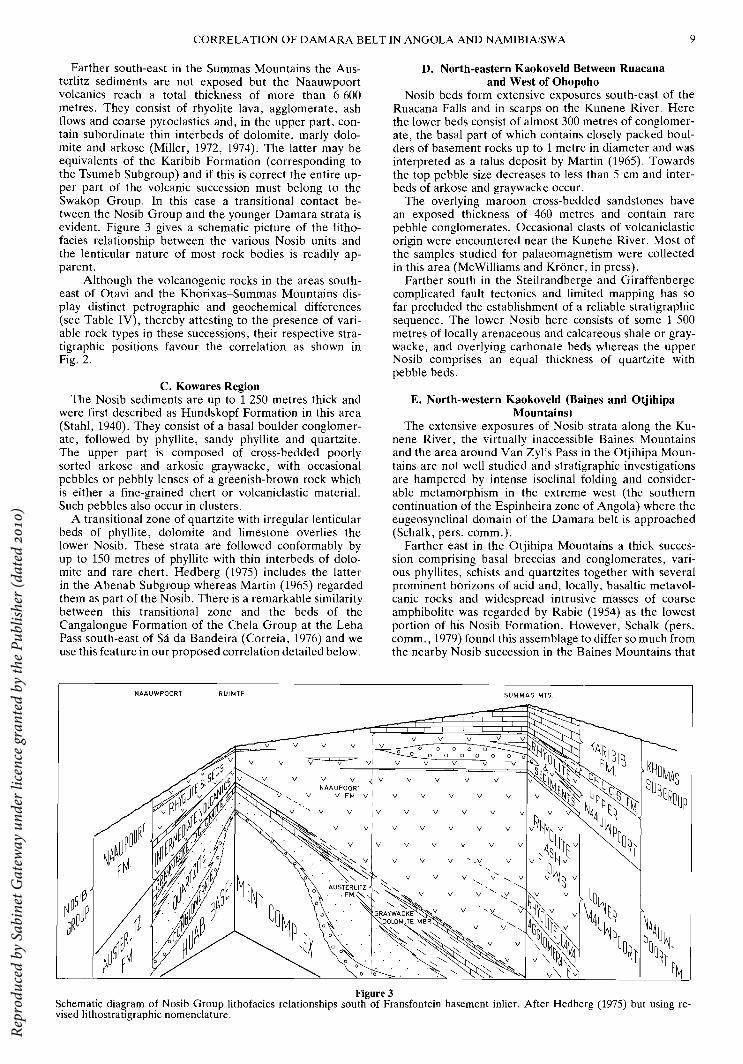
Farther south-east in the Summas Mountains the Austerlitz sediments are not exposed but the Naauwpoort volcanics reach a total thickness of more than 6 600 metres. They consist of rhyolite lava, agglomerate, ash flows and coarse pyroclastics and, in the upper part, contain subordinate thin interbeds of dolomite, marly dolomite and arkose (Miller, 1972, 1974). The latter may be equivalents of the Karibib Formation (corresponding to the Tsumeb Subgroup) and if this is correct the entire upper part of the volcanic succession must belong to the Swakop Group. In this case a transitional contact between the Nosib Group and the younger Damara strata is evident. Figure 3 gives a schematic picture of the lithofacies relationship between the various Nosib units and the lenticular nature of most rock bodies is readily apparent.
Although the volcanogenic rocks in the areas southeast of Otavi and the Khorixas-Summas Mountains display distinct petrographic and geochemical differences (see Table IV), thereby attesting to the presence of variable rock types in these successions, their respective stratigraphic positions favour the correlation as shown in Fig. 2.
C. Kowares Region The Nosib sediments are up to 1 250 metres thick and
were first described as Hundskopf Formation in this area (Stahl, 1940). They consist of a basal boulder conglomerate, followed by phyllite, sandy phyllite and quartzite. The upper part is composed of cross-bedded poorly sorted arkose and arkosic graywacke, with occasional pebbles or pebbly lenses of a greenish-brown rock which is either a fine-grained chert or volcaniclastic material. Such pebbles also occur in clusters.
A transitional zone of quartzite with irregular lenticular beds of phyllite, dolomite and limestone overlies the lower Nosib. These strata are followed conformably by up to 150 metres of phyllite with thin interbeds of dolomite and rare chert. Hedberg (1975) includes the latter in the Abenab Subgroup whereas Martin (1965) regarded them as part of the Nosib. There is a remarkable similarity between this transitional zone and the beds of the Cangalongue Formation of the Chela Group at the Leba Pass south-east of Sa da Bandeira (Correia, 1976) and we use this feature in our proposed correlation detailed below.
NAAUWPOORT RUIMTE
v
~
v v NAAUPOORT
v v FM
V
V
v
v
V
V
V
V
D. North-eastern Kaokoveld Between Ruacana and West of Ohopoho
Nosib beds form extensive exposures south-east of the Ruacana Falls and in scarps on the Kunene River. Here the lower beds consist of almost 300 metres of conglomerate, the basal part of which contains closely packed boulders of basement rocks up to 1 metre in diameter and was interpreted as a talus deposit by Martin (1965). Towards the top pebble size decreases to less than 5 cm and interbeds of arkose and graywacke occur.
The overlying maroon cross-bedded sandstones have an exposed thickness of 460 metres and contain rare pebble conglomerates. Occasional clasts of volcaniclastic origin were encountered near the Kunehe River. Most of the samples studied for palaeomagnetism were collected in this area (McWilliams and Kroner, in press).
Farther south in the Steilrandberge and Giraffenberge complicated fault tectonics and limited mapping has so far precluded the establishment of a reliable stratigraphic sequence. The lower Nosib here consists of some 1 500 metres of locally arenaceous and calcareous shale or graywacke, and overlying carbonate beds whereas the upper Nosib comprises an equal thickness of quartzite with pebble beds.
E. North-western Kaokoveld (Baines and Otjihipa Mountains)
The extensive exposures of Nosib strata along the Kunene River, the virtually inaccessible Baines Mountains and the area around Van Zyl's Pass in the Otjihipa Mountains are not well studied and stratigraphic investigations are hampered by intense isoclinal folding and considerable metamorphism in the extreme west (the southern continuation of the Espinheira zone of Angola) where the eugeosynclinal domain of the Damara belt is approached (Schalk, pers. comm.).
Farther east in the Otjihipa Mountains a thick succession comprising basal breccias and conglomerates, various phyllites, schists and quartzites together with several prominent horizons of acid and, locally, basaltic metavolcanic rocks and widespread intrusive masses of coarse amphibolite was regarded by Rabie (1954) as the lowest portion of his Nosib Formation. However, Schalk (pers. comm., 1979) found this assemblage to differ so much from the nearby Nosib succession in the Baines Mountains that
SUM MAS MTS.
v v v 0 0
v v v
v v v
V V V V
V V V
V V V V
V V V
V V V , ,~
v v v
v
v
Figure 3 Schematic diagram of Nosib Group lithofacies relationships south of Fransfontein basement inlier. After Hedberg (1975) but using revised lithostratigraphic nomenclature.
Rep
rodu
ced
by S
abin
et G
atew
ay u
nder
lice
nce
gran
ted
by th
e Pu
blis
her (
date
d 20
10)
10 TRANSACTIONS OF THE GEOLOGICAL SOCIETY OF SOUTH AFRICA
he described it as the "Okapuka Formation" of pre-Nosib age, probably correlatable with the ca. 1 800 Ma old Khoabendus Group farther south. It appears under this name on the new Geological Map of N amibia/SW A 1980. We agree with this interpretation since the continuation of the Okapuka strata across the Kunene River in Angola clearly forms part of the pre-Nosib basement. This furthermore suggests a correlation of the Okapuka (=Khoabendus) sequence with the MuvaAnkole Series in southern Angola.
Still farther east, in the Baines Mountains, the Nosib sequence is lithologically very similar to that in the Kowares region and is overlain unconformably by the upper Damara Tsumeb Subgroup. The Abenab sequence is missing here.
F. Depositional Environment In spite of the many local variations in the miogeosyn
clinal Nosib facies it is clear that the lower part of the sequence is a fluviatile to shallow water marine deposit. Moderate to strong relief of the pre-Nosib floor is evident from the coarse boulder conglomerates of local derivation. Conglomerates higher in the succession indicate the existence of basement highs, and it is therefore most likely that the Group is time-transgressive (Hedberg, 1975). The thick quartzite units are probably of fluviatile origin and represent filling in of considerable topographic relief, perhaps associated with the formation of several graben systems (Martin and Porada, 1977).
Farther into the Damara basin pelitic and calcareous intercalations are indicative of reduction in relief and transition to marine conditions.
The deposits in the transition zone to the Damara eugeosyncline are more varied and indicate frequent marine transgressions as well as sedimentation from basement ridges such as the Fransfontein inlier. Volcanism is prominent in this zone and may be related to periodic magmatic activity accompanying more rapid subsidence along the early Damara continental margin. This is particularly evident in the western Kaokoveld where volcanics of the Noeroep Formation interfinger with shales aI).d rhythmites possibly laid down by turbidity currents (Guj, 1970; Hedberg, 1975).
III. THE DAMARA SEDIMENTS IN THE IONAESPINHEIRA AREA OF SOUTHERN ANGOLA
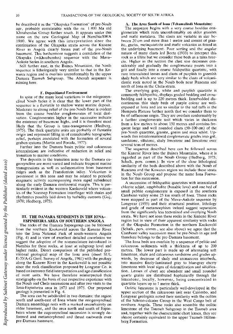
The rocks of the Damara Supergroup can be followed from the northern Kaokoveld across the Kunene River into the lona National Park of south-western Angola (Fig. 4) and in view of excellent detailed correlation we suggest the adoption of the nomenclature introduced in Namibia for these rocks, at least at subgroup level and higher ranks. Direct comparison of the published provisional geological map of the lona area (sheet SUL E-33/A-G Geol. Survey of Angola, 1961) with the geology along the Kunene River in the Kaokoveld is not possible since the rock classification proposed by Longyear Co. is based on incorrect field interpretation and age classification of most units. We have therefore reinterpreted their stratigraphy on the basis of our respective experience with the Nosib and Chela successions and after two visits to the lona-Espinheira area in 1973 and 1975. Our proposed geology is presented in Fig. 4.
The area can be subdivided in two domains: the region south and south-east of lona where the miogeosynclinal Damara assemblage rests with a marked unconformity on older basement, and the area north and south of Espinheir a where the eugeosynclinal succession is strongly deformed and metamorphosed and thrust eastwards over pre-Damara basement.
A. The Area South of lona (Tchamalindi Mountains) The sequence begins with a very coarse boulder con
glomerate which rests unconformably on older granites and mafic metalava. The clasts are variable in size between 20 cm and more than 1 metre and consist of granite, gneiss, metaquartzite and mafic volcanics as found in the underlying basement. Poor sorting and the angular nature of many clasts led Beetz (1933) to interpret this rock as a tillite but we consider these beds as a talus breccia. Higher in the section the clast size decreases considerably and gradually the conglomerate passes into a grit and finally into a coarse feldspathic quartzite, with rare intercalated lenses and clasts of purplish to greenish shaly beds which are very similar to the clasts of volcaniclastic rock noted in the Nosib beds near Ruacana and north of lona in the Chela strata.
The overlying gray, white and purplish quartzite is commonly feldspathic, displays graded bedding and crossbedding and is up to 220 metres thick. Interbedded discontinuous thin shaly beds of purple colour are wellexposed at lona and are so similar to the red tuffs in the Humpata Plateau farther north that we consider them to be of tuffaceous origin. They are overlain conformably by a further conglomerate unit which varies in thickness from a few metres to about 150 metres and contains frequent large and well rounded clasts (50-100 cm) of the pre-Nosib quartzite, granite, gneiss and mica schist. Upwards this intraformational conglomerate grades into grit, sandstone, siltstone, shaly limestone and limestone over several tens of metres.
The sequence described here can be followed across the Kunene River into the Baines Mountains, where it is regarded as part of the Nosib Group (Hedberg, 1975; Schalk, pers. comm.). In view of the close lithological similarity of the beds described above with the Nosib of Ruacana an.d the Kowares region we include these strata in the Nosib Group and propose the name lona Formation for this succession.
A succession of feldspathic quartzites with intercalated chlorite schist, amphibolite (basaltic lava) and one bed of small pebble conglomerate is exposed in the southern Cambeno valley some 25 km south of lona. These rocks were mapped as part of the Muva-Ankole sequence by Longyear (1955) and their structural position, lithology and grade of metamorphism indeed suggest separation from the significantly less tectoni-zed and overlying Nosib strata. We have not seen these rocks in the Kunene River region but in view of their apparent similarity with rocks of the Okapuka Formation in the northern Kaokoveld (Schalk, pers. comm., see also above) we agree that the Cambeno valley succession must be pre-No sib in age and therefore belongs to the pre-Damara basement.
The lona beds are overlain by a sequence of pelitic and calcareous sediments with a thickness of up to 200 metres. The lower part is made up of alternating soft limestone, shale and calcareous sandstone and grades upwards, by dec~ease of shaly and arenaceous interbeds, into massive finely-laminated gray to blue-gray cherty limestone with local signs of dolomitization and silicification. Lenses of chert are abundant and small rounded quartz grains are distributed haphazardly through the limestone, locally, however, being concentrated in quartzite layers up to 1 metre thick.
Oolitic limestone is particularly well-developed in the upper section of the calcareous unit near Caiombo, and Longyear geologists noted their similarity with the oolites of the Schisto-calcaire Group in the West Congo belt of northern Angola. These rocks also resemble the oolitic limestone of the Tsumeb Subgroup in the Tsumeb area and, together with the characteristic chert lenses, they are almost certainly equivalent to the upper Tsumeb Hiittenberg Formation. R
epro
duce
d by
Sab
inet
Gat
eway
und
er li
cenc
e gr
ante
d by
the
Publ
ishe
r (da
ted
2010
)

K a
12° 15'
I' \ \to Mo~amedes I X
S ,-----ESPlnhelr~a \ 1,\
\ A \
filr\\ ~~0 \ ~ '/(l \
g }) 0 \ \
1&
o k o
12"30'
x
x
X
X X
X
x
e
X
X
x
d
x
X( --
I /
x O(\Co~ )O .... ,;sz-
I I
I X 0
45'
X X x
x
X x x
x
45'
Figure 4
10 20 km
x a x
x
x x
x Legend:
c=J SAND, GRAVEL
~ MIXTITE, GRIT, SANDSTONE
[[JJ PORPHYROBLAST! C GNE I SS, BIOTITE SCHIST, QUARTZITE, AMPH I BOll TE, MARBLE (-)
~ CONGLOMERATE, SANDSTONE, SILTSTONE
~ LIMESTONE, DOLOMI TE, CHERT, SANDSTONE, SHALE
D CONGLOMERATE (0), GRIT, PEBBLY QUARTZITE, ARKOSE, MI NOR SHALE
0 BRECCIA, CONGLOMERATE, QUARTZI TE, SCHI ST, COARSE AMPHIBOLITE, METALAVA (v)
[2U GRANITE, GNEISS, SCHI ST METAVOLCAN I CS
METAMORPH IC EQU IVALENTS OF NOS I B & SWAKOP GROUPS IN AI,GOLA AND NAM I B I A
CAIOMBE FORMATION IN ANGOLA, UND I FF, MULDEN GROUP I N NAMIBIA
TCHAt-IALI ND I FORMAT! ON IN ANGOLA, UND I FF, TSUI~EB SUBGROUP IN NAM I B I A
laNA FORMATION IN ANGOLA, UNDI FF NOSIB GROUP IN NAMIBIA
MUVA-ANKOLE SEQUENCE IN ANGOLA, OKAPUKA FORMATION IN NAM I B I A
DWYKA GROUP
MULDEN GROUP
OTAVI GROUP
NOSIB GROUP
KHOA-BENDUS GROUP
I rrl
G>
co
II Based on maps of Longyear Company(1961}J Martin (1950}J
Hedberg (1975) as well as own observations
and photointerpretation Zchg. M.5chmlcklng, 1979
Geological sketch map showing distribution of miogeoclinal facies of Damara Supergroup and margin of high-grade Damara mobile belt in the north-western Kaokoveld of Namibia and the lona Game Park of south-western Angola.
Rep
rodu
ced
by S
abin
et G
atew
ay u
nder
lice
nce
gran
ted
by th
e Pu
blis
her (
date
d 20
10)

12 TRANSACTIONS OF THE GEOLOGICAL SOCIETY OF SOUTH AFRICA
The predominantly calcareous sequence described here is best developed in the rugged Tchamalindi Mountains south-east of lona and we suggest the name Tchamalindi Formation for these rocks. We have not seen the contact with the underlying lona Formation but on the official geological map it appears to be an unconformity. South of the Kunene River the equivalent strata rest unconformably on Nosib quartzite and are included in the Tsumeb Subgroup (Hedberg, 1975; Schalk, pers. comm.).
The above two sequences are overlain with a marked unconformity by the Caiombo Formation which consists of a discontinuous basal conglomerate followed by siltstone, shale as well as minor sandstone and quartzite. These beds display a remarkable increase in recrystallization and structural overprinting from north-east to southwest and are involved in complicated faulting and northwest-directed low angle thrusting. Due to these structural complexities Longyear geologists interpreted these rocks to be older than the lona and Tchamalindi beds and regarded them as Precambrian in age.
However, the Caiombo beds belong to the upper Damaran Mulden Group and are directly continuous across the Kunene River into the Kaokoveld where they are less deformed and rest unconformably on the carbonates of the Tsumeb Subgroup (Hedberg, 1975). The conglomerate exposed south of Caiombo constitutes the base of the Mulden Group and continues into the Omborombonga syncline in the Kaokoveld. It contains dolomite and chert fragments of the Tchamalindi Formation but was erroneously mapped by Longyear as part of the basal lona succession.
In conclusion we see little difficulty in recognizing the strata south of lona as lithostratigraphic units of the Damara Supergroup and our proposed correlation is shown in the legend of Fig. 4.
B. The Area South and North of Espinheira The rocks in this region differ markedly from the Dam
aran sediments only 20 km farther east at lona and constitute a strongly tectonized assemblage of schists and gneisses with intercalated bands of marble. The greenishgrey gneisses around Espinheira are composed of quartz, K-feldspar, biotite and hornblende and may represent the recrystallized equivalents of the Nosib Group or lower Swakop Group metasediments and associated mafic sills and dykes found farther south in the Kaokoveld. These rocks display a strong axial plane foliation dipping at shallow angles to the west, and through complete overprinting of earlier structures this foliation may develop into a regular banding.
The gneisses are thrust eastwards onto the older basement along a major thrust zone with shallow dip to the west (parallel to the foliation in the gneisses) which can be followed from the Kunene River northwards to Espinheira and then farther north-west in the direction of Porto Alexandre until it disappears under the dunes of the coastal desert.
The rocks mapped as "Desert gneisses" west of Espinheira by Longyear and classified as the Archaean basement complex of south-western Angola consist of a variety of metamorphic units with a predominance of dark grey biotite-garnet schist or biotite-garnet-feldspar gneiss. Kyanite is occasionally present in these rocks which are most probably derived from graywacke sediments and represent the high-grade metamorphic equivalent of the Khomas Subgroup schists in the Kaokoveld. The tightly infolded marble bands may correlate with the calcareous metasediments of the eugeosynclinal Karibib Formation or they represent layers within the lower Khomas succession as also found along the southern margin of the Damara belt.
The strongly deformed Damaran metasediments of the
coastal region of south-western Angola as far east as Espinheira are not directly comparable and correlatable with the much less tectonized to completely undeformed strata south of lona. The former are now considered part of the Pan African Damara orogenic belt and were subjected to the same degree of folding and metamorphism as the eugeosynclinal Damara strata in the central region of the orogen of Namibia. The latter rocks were deposited along the very margin of the Damara basin under fluviatile to shallow water conditions and suffered much less or no deformation because the underlying basement remained comparatively rigid during the Damaran Orogeny. The tectonic margin of the Damara belt in southern Angola should therefore be placed along the thrust zone described above.
IV. THE CHELA GROUP OF THE HUMPATA PLATEAU REGION
To the north of the lona region there are several scattered occurrences of undeformed rocks that rest nearly horizontally on the granitoid and gneissic basement and were originally included into the Chela Formation by Beetz (1933). Figure 5 shows the distribution of these occurrences in south-western Angola and the following description concentrates on the best studied area, namely the Humpata Plateau south of Sa da Bandeira, for which three detailed maps were published (Vale, 1971, 1973a, b).
Vale (op. cit.) subdivided the succession into three series with a lithology as summarized in Table II. The two lower units were regarded as Cambrian whereas a Silurian age was assigned to the upper stromatolite-bearing carbonates.
A detailed reinvestigation of the Chela stratigraphy led to the discovery of a hitherto unrecognized thick volcaniclastic unit (Correia, 1973) and resulted in a
~_'O~O ~200km
Z
<!
UJ
U
0
U
Z <1-
<! :0':1.\
",0'"
<!
'? 0, "0 <! l'
Cll
:=£
« N
( SOUTH WEST AFRICA)
c:::;:::] ~~;~~~~:~( :la?fo~~r~acles ) CI:JJ Damara Supergroup
in high -grade mobile belt
[ZLl Schisto-greseux & } Schisto -calcaire Groups West Congo
LJ Sansikwa Group Supergroup
Figure 5 Geographic distribution of Chela Group in Angola and margin of high-grade Pan African Damara mobile belt. Also shown is situation of West Congo belt in northern Angola. 1 = Humpata Plateau,2 = Pocolo, 3 = Curoca, 4 = lona-Baines Mountains, 5 = Ediva, 6 = Calueque. Small square across Kunene River shows location of Figure 4.
Rep
rodu
ced
by S
abin
et G
atew
ay u
nder
lice
nce
gran
ted
by th
e Pu
blis
her (
date
d 20
10)

CORRELATION OF DAMARA BELT IN ANGOLA AND NAMIBIA/SW A 13
TABLE II Lithostratigraphic Subdivision of the Chela-Leba Sequence in the Humpata Plateau Region of Southern Angola, after Vale and
Correia.
Vale (1971, 1973a, b) Form. Series Lithology
Bedded dolomitic limestone,
UPPER frequently silicified. Com-mon flint formation parallel to stratification. In some places stromatolites.
"'Angular Unconformity N\NVV
Brown, red, yellow and gray shale
Red siltstone
Ferruginous red sandstone
tHE LA
MIDDLE White feldspathic sandstone
White, pink or grayish quartzite grading into sandstone and vice versa. Some chert intercalations.
LOWER Basal conglomerate with quartzite matrix
Vvv-Major unconformity""""""'"
Igneous Precambrian basement
complete reVlSlon of the Humpata Plateau stratigraphy (Correia, 1976). The succession as now defined consists of four formations making up the Chela Group and representing a complete tectono-sedimentary cycle. The carbonate sequence of Vale (op. cit.) has been separated from the Chela Group and constitutes a formation which can be related to a younger graben-controlled sedimentary cycle. Its full original thickness is not exposed in the area. The new formal subdivision (Correia, 1976) is given in Table II.
The Chela Group rests with a marked unconformity on an igneous basement of undifferentiated Precambrian age whose morphology was irregular (Faber, 1926) and thus contributed to the remarkable thickness variations in the overlying Chela beds. Mendes (1968) reported a considerable number of Rb-Sr mineral and whole rock ages from the basement west and south of the Chela Plateau which range from ca. 1 060 Ma to more than 2 500 Ma (recalculated with )YRb = 1,42 x 1O-11a- 1
). The youngest of these are biotite and whole rock model ages based on only one determination per rock unit and are therefore extremely unreliable. They vary between 1 060 and 1 112 Ma and may date a metamorphic event in the preChela basement or may reflect an igneous episode (Carvalho, 1972). However, since the Chela is completely unmetamorphosed and not orogenically deformed we suggest that its deposition post-dates the event reflected by the above ages.
The Chela basin is fault-bounded in the east and has a wedge-shape with two main thickening components to the south and east. We think that this asymmetry is a primary feature due to synsedimentary fault tectonics in the mar-
Correia (1976) Member and lithology Formation Group
Dolo-algal boundstone (stromato-litic), dolo-wackestone and pack- LEBA stone, chert.
~Paraconformity C3 Red shale and siltstone with
sandstone intercalations CANGA-
C2 Red feldspathic sandstone LONGUE
C1 Gray shale, arenite and limestone
B3 Fine-grained arenite and silt-stone
B2 Fine-grained arenite
B1 Medium-grained arenite with a BRUCO red-weathered lapillitic tuff
~, Bo BlOPE RUDITE MEMBER __
H2 Red acidic welded tuff CHELA
H1 Volcaniclastic unit with sand-stone intercalations at the HUMPATA base
Ho Red acidic tuff T2 TECHALUNDIANGA ARENITE
MEMBER
T1 SENHORA DO MONTE QUARTZ-~~MEMBER
TUNDAVALA To HUNGUERIA
CONGLOMERATE MEM~ ~Major unconformity
Igneous basement of undifferentiated Precambrian age
ginal part of the cratonic platform of the Congo Shield but temporally related to early subsidence in the Damaran geosyncline farther south-west.
The lithostratigraphic units of the Humpata Plateau are shortly characterized from bottom to top as follows:
A. Tundavala Formation This basal sequence of the Chela Group has a thickness
of 20-80 metres and consists of local conglomerate, quartzarenite and lithic to feldspathic arenites with finegrained red volcaniclastic intercalations. Cross-bedding is common. Correia (1976) proposed a subdivision into three members as shown in Table II. Since the base of the Chela is diachronous the middle quartzarenite member locally rests directly on basement.
B. Humpata Formation Resting conformably on the Tundavala arenites this se
quence consists of grey-green fine-grained acid volcaniclastic rocks with two persistent beds of red acidic tuff at the base and top. The thickness varies between 100 and 300 metres.
The volcaniclastic beds, first recognized and described in detail by Correia (1973), are extremely fine-grained, highly siliceous and look like chert in hand specimen. Under the microscope well-preserved divitrified glass shards can be recognized. The rocks show good stratification and display well-preserved sedimentary structures such as graded bedding (normal and reverse), convolute bedding, small-scale alpha cross-bedding and ripple marks. These features attest to the subaqueous origin of the pyroclastic succession whereas ignimbritic flow structures in the uppermost red tuff may indicate deposition above sea level.
Rep
rodu
ced
by S
abin
et G
atew
ay u
nder
lice
nce
gran
ted
by th
e Pu
blis
her (
date
d 20
10)

14 TRANSACTIONS OF THE GEOLOGICAL SOCIETY OF SOUTH AFRICA
C. Bruco Formation A sharp boundary separates this mixed volcano-sedi
mentary unit with a maximum thickness of about 100 metres from the Humpata Formation. The basal part is conglomeratic in places and the intra basinal origin of the clasts (largely from the topmost red siliceous voicaniclastic horizon of the Humpata sequence) suggests a minor erosional unconformity. The basal rudite member is overlain by arenites which may overlap directly on the Humpata volcaniclastics and which contain a characteristic persistent bed of lapillitic tuff.
The arenites are cross-bedded and the sequence as a whole has characteristics suggesting a fluvial enviroriment of deposition (Correia, 1976).
D. Cangalongue Formation This unit constitutes the top of the Chela Group and
has a maximum thickness of 72 metres. Its lower contact with the Bruco Formation is transitional and the boundary was placed where shales and limestones appear in the sequence. Grey lutitic rocks and limestones with thin intercalations of arenites and highly ferruginous sandstones in the lower part are overlain by red sandstones and flaggy red shales and siltstones.
The upper boundary is defined by a sharp lithological discontinuity between red lutites and overlying carbonate rocks of the Leba Formation. The regional study of Correia (1976) suggests a significant time break between these units so that a paraconformity may be inferred at the top of the Chela Group.
E. Leba Formation This unit has been separated from the Chela Group on
account of its contrasting lithology and the inferred time break referred to above. Vale (1971, 1973a, b) described a low angle unconformity at the base of the Leba sequence but our field observations do not substantiate this interpretation. The thickness varies around 20-30 metres but can reach 60 metres in places; the succession is incomplete and a substantial upper part may have been removed by erosion.
The formation consists of a homogeneous carbonate unit with dolostone as the dominant rock type. Towards the top flaggy chert .layers are common. Ripple marks and graded bedding are common and cross-bedding as well as micro-cross-lamination indicate strong variability of palaeocurrent directions. Stromatolitic structures are nearly everywhere present in the dolostones. The most frequent forms are LLH types of Logan et al. (1964) but SH-V and SS-C types also occur. The thin lamination of the rocks has an algal origin and may have been produced by "mode P" stromatolites of Aitken (1967).
The presence of anhydrite may be taken as evidence for a primary evaporitic origin of the dolomite and the syngenetic chert bands may reflect seasonal variations in the depositional milieu. The Leba Formation rocks are interpreted as a stromatolitic biostrome formed in a tidal flat environment.
V. CORRELATION, AGE AND PALAEOMAGNETISM
The descriptions so far presented suggest a correlation of the sequences exposed south of lona with the Nosib, Otavi and Mulden Groups in Namibia. In fact the continuity of outcrop from one territory to the other across the Kunene River justifies inclusion of these strata into the formal lithostratigraphic units of subgroup and group rank as established for the Damara Supergroup and no separate name is therefore necessary for the lona succession as a whole.
The Chela and Leba rocks of the Humpata Plateau cannot be followed conti~uously to the south as far as
lona and the internal stratigraphy and lithology is sufficiently different from that of the Nosib to warrant separate names. However, we regard the combined Chela and Leba sequences so similar to the Damaran Supergroup in their general setting, broad stratigraphy, evolution, age and palaeomagnetism that the conclusion seems inescapable to correlate these units as has already been proposed by Carvalho (1972) and Correia (1976). More particularly we suggest the correlation of the Chela Group as here defined with the Nosib Group of lona and northern Namibia and the Leba Formation with the Tsumeb Subgroup of the Otavi Group as shown in Table III.
TABLE III Suggested Lithostratigraphic Correlation Between Nosib and Otavi Groups of Northern Namibia and Chela Group and Leba
Formation of the Humpata Plateau in Southern Angola.
Group Subgroup Formation Formation Group
Hiittenberg
Otavi Tsumeb Elandshoek
Maieb~ Chuos
Unconformity
r---Leha--
Paraconformi ty
Varianto and
Nosib Hundskopf Naauwpoort Austerlitz and Nabis
Cangalongue Bruco
Humpata Chela
Tundavala
The Nosib-Chela correlation is based on the following arguments: Both sequences represent the initial infilling of a basin or basins with considerable relief on the Congo Craton during the early stages of Pan African crustal evolution. They represent fluviatile to shallow water marine deposits and thickness variations, facies changes over short distances, interspersed conglomerates and intermittent, predominantly acid volanic activity all point to an evolution in graben-controlled troughs which developed in a tensional crustal environment, probably initiating rifting which finally led to the formation of the Damara geosyncline farther south-west and south (Martin and Porada, 1977).
The basal conglomerates of the Chela and Nosib sequences are directly comparable. Both are of local derivation and in many cases represent talus deposits. A glacial origin as inferred by Beetz (1933) and Vale (1971, 1973a, b) can be denied. The feldspathic quartzites of both units are identical in appearance and largely represent fluviatile deposits. The volcanic and volcaniclastic rocks document intermittent and localized magmatic activity that may not always have been contemporaneous over the entire area of Nosib-Chela deposition. The short-distance facies change and extreme thickness variations in the Welwitschia-Summas Mountains region of Namibia as depicted in Fig. 2 illustrates this point. It is therefore not surprising to find extensive areas of Nosib sediments without intercalated volcanic rocks. However, clasts of what we consider to be volcaniclastic material are frequently present in the Nosib arenites of the Kowares region, the north-eastern Kaokoveld and the lona area and may indicate variable intensity of widespread volcanic activity during Nosib times. The thick felsic volcanics of the Naauwpoort Formation are predominantly rhyolitic in composition whereas the volcaniclastic beds of the Humpata Formation have a high-K rhyolite affinity (Table IV), although strong silicification and leaching of Na20 is apparent. The latter process can be ascribed to secondary devitrification of glassy tuff which frequently results in loss of sodium and gain of potassium (Lipman, 1965).
Rep
rodu
ced
by S
abin
et G
atew
ay u
nder
lice
nce
gran
ted
by th
e Pu
blis
her (
date
d 20
10)

CORRELATION OF DAMARA BELT IN ANGOLA AND NAMIBIA/SWA 15
TABLE IV Average Chemical Composition of Acid Volcanisclastic and Volcanic Rocks from Chela Group, Angola, and Nosib Group,
Namibia.
Oxide 1 2 3 SiOz 74,29 74,36 74,00 TiOz 0,35 0,16 0,30 Alz0 3 14,28 11,66 12,72 Fez0 3 2,56 0,92 3,36 FeO 0,18 0,63 0,29 MnO 0,01 0,05 0,02 MgO 1,10 0,12 0,85 CaO 0,13 0,22 0,75 NazO 0,08 1,89 7,94 KzO 4,90 7,49 0,22 PzOs 0,12 n.d. 0,06 LOI 2,43 0,92 0,32 HzO- 0,27 0,05 0,14
Total 100,70 98,47 100,97 1. Average of fIve an lyses of volcaniclastic rocks from Humpata
Formation, Chela Group (Correia, 1973). 2. Average of four analyses of rhyolite lava and ash flows,
Naauwpoort Formation, Nosib Group (Miller, 1972). 3 Average of two analyses of feldspar rhyolite lava, Naauwpoort
Formation, Nosib Group (Frets, 1969).
Considerable similarities are again apparent in the lithology of the uppermost Nosib of the Kowares region (p. 9), the higher units of the lona Formation and the Cangalongue Formation in the Humpata Plateau. In all three areas interbeds of calcareous shale, phyllite and limestone are found in the frequently micaceous arenites, and this may indicate a gradual change from fluviatile to shallow marine depositional environments.
The Leba Formation has many similarities with the Tsumeb Subgroup carbonates of the Otavi Group, particularly on account of the presence of chert bands and the ubiquitous presence of stromatolite structures. The oolitic chert marker of the uppermost Tsumeb succession was, however, not found in the Humpata Plateau and we suggest that the Leba Formation corresponds to the middle Tsumeb Maieberg and Elandshoek formations. This correlation also agrees well with the stratigraphy of the Tchamalindi Formation near lona and the Tsumeb beds in the Kunene area of the Kaokoveld. In all these regions the basal Tsumeb Chuos mixtite is not developed and it is likely that this characteristic unit wedges out in the Kaokoveld before reaching the Kunene River. In view of the apparent absence (i.e. non-deposition) of the entire Abenab Subgroup and Chuos Formation in the Humpata Plateau and in the lona region, our interpretation of a significant hiatus between the Chela-Nosib and the Leba-Tchamalindi successions gains considerable weight.
Geochronological correlation of the Nosib and Chela groups is less convincing at present, due to the lack of reliable age data for these units themselves. The rhyolite lavas of the upper Nosib Naauwpoort Formation have so far yielded ambiguous 207PbP06Pb zircon dates of 742 ± 40 Ma and 770 ± 30 Ma respectively which must be interpreted as minimum ages (Burger, p~rs. comm., and Kent, 1973). Kroner (1980) has dated the Oas Syenite near Khorixas (Welwitschia) at 840 ± 12 Ma (Rb-Sr whole rock 9-point isochron) and this is again a minimum age for the Nosib since the Oas complex intruded the Nosib sediments.
The Chela succession as well as the overlying Leba carbonates were intruded in the Humpata Plateau by a considerable number of dykes and sills of noritic to doleritic composition. The whole rock K-Ar age of 800 ± 13 Ma of an associated granodiorite (Torquato and Amaral, 1973) gives a minimum age for the Chela and this is comparable to the ages obtained for the Nosib in Namibia. Rb-Sr whole rock measurements on some of the volcaniclastic rocks of the Humpata Formation by one of us
GEOL 83/1 - 8
(A.K.) have so far not yielded acceptable results and it is suspected that detrital components in these rocks retained their pre-Chela isotopic "memory". Work on the fine clay fractions <2 !l is now in progress and preliminary data indicate an age between 860 and 910 Ma.
The upper age limit for the Chela is given by the basement mineral ages of 1 060-1 080 ± 60 Ma mentioned earlier (p. 13). It is therefore difficult to accept the statement of Torquato (1974) that the Chela should be older than 1 490 Ma and we suspect that the granitic rocks dated by Torquato are not intrusive into the Chela Group sediments but into older quartzites which were erroneously correlated with the Chela, the more so since Torquato (1974) mentions that the rocks dated by him are intrusive into folded quartzites.
Also uncertain are the precise field relationships of the apprently 1 481 ± 43 Ma old Vila Arriaga mafic dyke with the flat-lying Chela strata. According to Torquato (1974) this dyke is intrusive but we have not been able to find the direct contact with the Chela rocks and it is possible that the dyke pre-dates the Chela Group. We are presently investigating other mafic dykes cutting Chela rocks in the Humpata Plateau by the Rb-Sr method and preliminary data indicate Karoo ages (ca. 210 Ma).
Palaeomagnetic data for both the Nosib and Chela are also available and show excellent agreement. McWilliams and Kroner (in press) report a primary Nosib pole at 28°S, 143°E for sediments sampled near Ruacana and Kowares in the Koakoveld, whereas preliminary data for the Chela Group of the Humpata Plateau suggest a pole at 30oS, 143°E (Jones, Kroner and Correia, in prep.). Both poles are situated on the apparent polar wander path for Africa and indicate a magnetization age between 900 and 1 000 Ma (McWilliams and Kroner, op. cit.).
We are therefore confident that our proposed correlation scheme as detailed in this paper is correct and that the Chela occurrences of southern Angola can thus be regarded as an integral part of Pan African depositional history along the margin of the Congo Craton. It is furthermore significant that the Chela and Nosib deposition appears to be contemporaneous with the early clastic sediments of the Pan African Gariep belt in southern Namibia and South Africa (Kroner, 1975) and the West Congo belt of northern Angola and lower ZaIre (Cahen, 1978; Jones, Kroner and Correia, in prep.). The lithological similarity of all these sequences over a distance of more than 3 000 km suggests to us that comparable crustal processes involving tensional movements, faulting and graben formation - all probably related to rifting - affected virtually the entire west coast of present central and southern Africa. We speculate that these features may be related to an attempt of crustal separation in Precambrian Gondwanaland, thereby initiating the Pan African event.
VI. CONCLUSIONS 1. The Nosib Group of northern Namibia and the Chela
Group of southern Angola constitute part of the early Pan African sedimentary cycle associated with the development of the Damaran geosyncline. Both sequences can be correlated on lithostratigraphic, geochronologic and palaeomagnetic grounds.
2. The sediments of the lona area are direct correlates of the Nosib, Otavi and Mulden groups of the Damara Supergroup and should therefore be included in these units. There is no tillite at the base of this succession.
3. Geochronology and palaeomagnetism suggest a depositional age of ~870-1 020 Ma for the Nosib and Chela groups and an age younger than ~850 Ma for the overlying Otavi Group and Leba Formation. An early Palaeozoic age is no longer tenable.
Rep
rodu
ced
by S
abin
et G
atew
ay u
nder
lice
nce
gran
ted
by th
e Pu
blis
her (
date
d 20
10)

16 TRANSACTIONS OF THE GEOLOGICAL SOCIETY OF SOUTH AFRICA
4. The highly tectonized northern part of the Damara belt extends into southern Angola west of lona and can be followed in the direction of Porto Alexandre before it disappears under younger cover. The belt does not continue along the Angolan coastline and link up with the West Congo belt farther north as frequently suggested in the literature. Instead it seems to trend obliquely across the coast and a possible continuation may be sought in the time-equivalent Ribeira or Brasilia belts of coastal Brazil (Torquato, 1976).
5. The remarkable age and lithologic correlation of early Pan African deposits over more than 3 000 km along the west coast of Africa between South Africa and Gabon may signify contemporaneous crustal activity related to incipient rifting and possible breakup of Gondwana segments in late Precambrian times.
ACKNOWLEDGMENTS We thank the University of Luanda for financial sup
port during fieldwork in Angola in 1973 and A.K. further gratefully acknowledges funding, logistic support and hospitality of Dr. J. de Villiers and his field staff of Johannesburg Consolidated Investment Company during a second fieldtrip to southern Angola in 1975. H. Martin and K.E.L. Schalk kindly reviewed the text and we appreciate their suggestions which considerably improved the manuscript. M. Schmicking prepared most figures.
REFERENCES Aitken, J.D. (1967). Classification and environmental signifi
cance of crypt algal limestones and dolomites with illustrations from the Cambrian and Ordovician of southwestern Alberta. J. Sed. Petrol., 37,1163-1178.
Beetz, P.F.W. (1933). Geology of South West Angola between Cunene and Lunda axis. Trans. geol. Soc. S. Afr., 36, 137-178.
Cahen, L. (1978). Vue d'ensemble sur la base du Supergroupe Ouest-Congolien et la stratigraphie du Groupe de la Sansikwa. Rapp. anu. 1977, Mus. roy. Afr. centr., Dept. Geol. Min. Tervuren, 65-79.
Carvalho, H. de (1972). Chronologie des formations geologiques Precambriennes de la region centrale du Sud-Ouest de I' Angola et essai de correlation avec celles du Sud-Ouest Africain. 24th Int. Geol. Congr. Montreal, 1, 187-194.
Clifford, T.N. (1967). The Damaran episode in the upper Proterozoic-lower Paleozoic structural history of southern Africa. Spec. Pap. geol. Soc. Amer., 92, 100 pp.
- - - -, Nicolaysen, L.O., and Burger, A.J. (1962). Petrology and age of the pre-Otavi basement granite at Fransfontein, northern South West Africa, J. Petrol., 3, 244-278.
Correia, H. (1973). Sobre a existencia de rochas vulcanoclasticas na Formacao da Chela (Regiao do Planalto da Humpata). Cien. Geol., Cursos de Ciencias, Univ. Luanda, 1,27-32.
- - - - (1976). 0 grupo Chela e a formacao Leba como novas unidades litoestratigrMicas result antes da redfinicao da Formacao da Chela na regiao do planalto da Humpata (Sudoeste de Angola). Bol. Soc. Geol, Portugal, 20,65-130.
De Villiers, J. (1972). The younger Precambrian. 7th-9th Ann. Rep., Precambrian Res. Unit, Univ. Cape Town, 48-51.
Faber, F.J. (1926). Bijdrage tot de geologie van Zuid Angola. Ph.D. thesis (unpubl.), Technische Hoogeschool Delft, Netherlands.
Frets, D.e. (1969). Geology and structure of the Huab-Welwitschia area, South West Africa. Bull. Precambrian Res. Unit, Univ. Cape Town. 5,235 pp.
Germs, G.J.B. (1975). Silification structures from the upper Otavi Group, and the signifance of chert in this unit. Trans. geol. Soc. S. Afr., 78,67-70.
Guj, P. (1970). The Damara mobile belt in the southern Kaokoveld, South West Africa. Bull. Precambrian Res. Unit, Univ. Cape Town, 8, 168 pp.
Hawkesworth, e.J., Miller, R. McG., and Roddick, J.e. (1977). Geochronology in the Damarides. Abstr.-vol., 9th Coll. Afr. Geol. Gottingen, 44.
Hedberg, R. (1975). Stratigraphy of the Ovamboland basin, South West Africa. Ph.D. thesis (unpubl.), Harvard Univ., Cambridge, Mass.
Jones, D.L., Kroner, A., and Correia, H. Palaeomagnetism of Late Precambrian sequences and the recognition of new Karoo Strata in Angola (in prep.).
Kent, L.E. (Editor) (1973). Geochronology. In: Ann. geol. Surv. S. Afr., 9, (1971-72),20-21.
Kroner, A. (1975). Late Precambrian formations in the western Richtersveld, northern Cape Province. Trans. roy. Soc. S. Afr., 41,375-433.
- - - - (1977a). Precambrian mobile belts of southern and eastern Africa - ancient sutures or sites of ensialic mobility? A case for crustal evolution towards plate tectonics. Tectonophysics, 40, 101-135.
- - - - (1977b). Non-synchroneity of Late Precambrian glaciations in Africa. Jour. Geol., 85, 289-300.
- - - - (1980) Chronologic evolution of the Pan African Damara belt in Namibia southwestern Africa. In: H. Closs, K.v. Gehlen, H. Illies, E. Kuntz, J. Neumann, and E. Seibold (Eds.), Mobile Earth, International Geodynamics Project, Final Report of the Federal Republic of Germany, Harald Boldt Verlag, Boppard, 221-224.
Lipman, P.W. (1965). Chemical comparison of glassy and crystalline volcanic rocks. Bull U.S. Geol. Surv., 1201-D, 24 pp.
Logan, B.W., Rezak, R., and Ginsburg, R.N. (1964). Classification and environmental significance of algal stromatolites. Jour. Geol., 72,68-83.
Longyear, E.J. (1955). Report to the Government of Portugal on the Curoca area, Angola, Portuguese West Africa (unpubl.). Condensed version in: Noticia explicativa das folhas (provisorias) Iona e Oncogua, escala 1 : 250.000, Servo Geol. Minas Angola, 22 pp. (1961).
Martin, H. (1950). Unpublished geological map of the northern Kaokoveld, South West Africa. Precambrian Res. Unit, Univ. Cape Town.
- - - - (1965). The Precambrian geology of South Africa and Namaqualand. Precambrian Res. Unit, Univ. Cape Town.
- - - - , and Porada, H. (1977). The intracratonic branch of the Damara orogen in South West Africa. I. Discussion of geo-dynamic models. Precambrian Res., 5,311-338. .
McWilliams, M.O. and Kroner, A. (in press). PaleomagnetIsm and tectonic evolution of the Pan-African Damara belt, southern Africa. J. Geophys. Res.
Mendes, F. (1968). Mesures geochronologiques en Angola. Deuxieme these, Univ. Clermont-Ferrand, 23 pp.
Miller, R. McG. (1972). The geology of a portion of southern Damaraland, South West Africa, with particular reference to the petrogenesis of the Salem granite. Ph.D. thesis (unpubl.), Univ. Cape Town.
- - - - (1974). The stratigraphic significance of the Naauwpoort Formation of east central Damaraland, South West Africa. Trans. geol. Soc. S. Afr., 77,363-367.
Mouta, F. (1951). Carte geologique de l'Angola (Notice explicative). 18th Int. Geol. Congr., London 1948, 14, 118-130.
Rabie, L.P. (1954). Unpublished map of the Bethlehem Steel Corporation. Geol. Surv. South West Africa, Windhoek.
Schalk, K.E.L. (1972). Some Late Precambrian formations in central South West Africa. Ann. geol. Surv. S. Afr., 2, (for 1970),29-47.
Stahl, A. (1926). Geologische Grundziige des nordlichen Siidwestafrika und Erzlagerstiitten des Otaviberglandes. Zeitschr. prakt. Geol., 34, 145-160.
- - - - (1940). Die Otaviformation des Etoschabogens (Siidwestafrika). Beitr. geol. Erforsch. dt. Schutzgeb., H. 22.
Stanton, W.I., Schermerhorn, L.J.G., and Korpershoek, H.R. (1963). The West Congo System. Servo Geol. Minas Angola, Bol. 8,69-78.
Torquato, J .R. (1971). The Damara System in Angola (some preliminary observations on the existence of two geosyncline facies). Rel. Com. Inst. Inv. Cient. Angola, 13,27 pp.
- - - - (1974). Algumas consideracoes sobre a idade do Grupo Chela. Mem. Servo Geol. Minas Angola, 14, 10 pp.
- - - - (1976). Geotectonic correlation between SE Brazil and SW Africa. An. Acad. bras. Cienc., 48,353-363.
- - - - , and Amaral, G. (1973). Idade K/Ar em rochas das regioes de Catanda e Vila de Almoster. Inst. Inv. Cient. Angola, Bol., 10, 7 pp.
Vale, F.S. (1971). Noticia explicativa da carta geol6gica de Angola, folha 336 (Sa da Bandeira), 1 : 100.000. Servo Geoi. Minas Angola, 36 pp.
- - - - (1973a). Noticia explicativa da carta geol6gica de Angola, folha 355 (Humpata-Cainde), 1 : 100.000. Servo Geoi. Minas Angola, 45 pp.
- - - - (1973b). Noticia explicativa da carta geol6gica de Angola, folha 356 (Vila Joao de Almeida), 1 : 100.000. Servo Geoi. Minas, Angola, 42 pp.
A. Kroner, lnstitut fur Geowissenschaften, lohannes-Gutenberg-Universitat, Postfach 3980, 6500 Mainz, West Germany.
H. Correia, Instituto de Geociencias dos Acores, 2 Rua de S. Miguel, Ponta Delgada, Ilha de S. Miguel, Acores, Portugal.
Accepted for publication by the Society on 7.6.1980.
Rep
rodu
ced
by S
abin
et G
atew
ay u
nder
lice
nce
gran
ted
by th
e Pu
blis
her (
date
d 20
10)