Embed Size (px)
Citation preview

Conferences Program and Information
3rd International Conference on Smart Data and Smart Cities
4 – 5 October
ISPRS Technical Commission IV Symposium
1 – 5 October
6th International FIG Workshop on 3D Cadastres
2 – 4 October
13th 3D GeoInfoConference
1 - 2 October

GeoConnexion
O R G A N I S E D B Y :
M E D I A P A R T N E R S :
S U P P O R T E D B Y :
S P O N S O R E D B Y :
Content 5 Local Organising Committee
6 Aulafloormap
7 Word of welcome
8 Welcome to Delft – Practical information
10 Program at a Glance
11 Conferences Program
12 Keynotes
14 Fieldtrips
16 ISPRSfullprogram
23 3DGeoInfofullprogram
33 3DCadastresfullprogram
38 Smart Data Smart Cities
42 Notes
G O L D S I L V E R B R O N Z E
3

L O C A L O R G A N I S I N G C O M M I T T E E G E O D E L F T C O N F E R E N C E S 2 0 1 8
Peter van OosteromDelft University of Technology, the NetherlandsChair 6th International FIG Workshop on 3D Cadastres
Sisi ZlatanovaUNSW Sydney, Australia Chair ISPRS Technical Commission IV Symposium
Volker CoorsHochschule für Technik Stuttgart, GermanyChair 3rd International Conference on Smart Data and Smart Cities
Mila KoevaUniversity of Twente, the NetherlandsCo-chair 13th 3D GeoInfo Conference
Jantien StoterDelft University of Technology, the NetherlandsCo-chair 13th 3D GeoInfo Conference
Hendrik WesterbeekGeo-informatie Nederland, the NetherlandsExhibition & Sponsoring and Representative GIN/Kadaster
Elfriede FendelDelft University of Technology, the NetherlandsPractical conference organisation
Maarten Sauter Delft University of Technology, the Netherlands Practical conference organisation
DenisevanAsperenDelft University of Technology, the Netherlands Support conference organisation
5

Aula floor map
FRANS VAN HASSELTZAAL
SECOND FLOOR
FIRST FLOOR
GROUND FLOOR
LINKS TO THE OPEN AND ON-LINE PROCEEDINGS
The ISPRS TC IV ‘Spatial Information sciences’ Symposium (1 – 5 October 2018):l https://www.isprs-ann-photogramm-remote-sens-spatial-inf-sci.net/IV-4/l https://www.int-arch-photogramm-remote-sens-spatial-inf-sci.net/XLII-4/
The 13th International 3D GeoInfo Conference (1 – 2 October 2018):l https://www.isprs-ann-photogramm-remote-sens-spatial-inf-sci.net/IV-4-W6/l https://www.int-arch-photogramm-remote-sens-spatial-inf-sci.net/XLII-4-W10/
The 6th International FIG Workshop on 3D Cadastres (2 – 4 October 2018):l http://www.gdmc.nl/3DCadastres/workshop2018/programme/
The 3rd International Conference on Smart Data and Smart Cities (4 – 5 October 2018):l https://www.isprs-ann-photogramm-remote-sens-spatial-inf-sci.net/IV-4-W7/l https://www.int-arch-photogramm-remote-sens-spatial-inf-sci.net/XLII-4-W11/
Word of welcome Delft, October, 2018
Dear participants,
A warm welcome to the Geo Delft Conferences 2018 in the Aula Congress Center at Delft University of Technology! By organizing together four renowned geo-information events, there is a lot of great content to choose from. We hope and expect that the interaction between the four communities will be highly appreciated. The four events are: 1. the ISPRS (International Society for Photogrammetry and Remote Sens-ing) Technical Commission IV Spatial Information Science Symposium, 2. the 13th 3D GeoInfo Conference, 3. the 6th International FIG (International Federation of Surveyors) Workshop on 3D Cadastres, and 4. the 3rd International Con-ference on Smart Data and Smart Cities by the Urban Data Management Society (UDMS). Never before did these four events join forces. This programme booklet contains all practical information needed to find your optimal route through the conferences. Based on open call for contributions, authors have submitted their proposals to one of the four events. The contributions have been reviewed by the members of the relevant Pro-gramme Committees. Based on the reviews the programme chairs have selected the papers, which we asked to submit a revised full paper considering the review comments. The scientific content has been collected in proceedings, which are all open access. The FIG publishes the proceedings of the 3D Cadastres workshop. Copernicus publishes in the ISPRS Annals and ISPRS Archives the proceedings of the three other events. In total 500 participants are expected, attending the confer-ences and the related activities, such as the exhibition, field trips, posters, joint plenary sessions, best paper awards, and various social events. The plenary opening is combined with a session ‘Best of the Netherlands’, in which we proudly present a range of advanced geo-information solutions. The keynote presentations are all planned in plenary session, where the
different event mingle. A range of exiting field trips are organ-ized, including: Delft Spoorzone (the first ever real 3D parcels registered by Dutch Cadastre), Monitoring tilting Old Church in Delft (by Sweco), Maeslantkering (and visit to Datalab Rijk-swaterstaat), 3D Rail corridor modelling (by Fugro), 3D-SDI/ SmartCity (Rotterdam).The partner organizations are acknowledged for their en-thusiastic collaboration during the preparation of the Geo Delft 2018 Conferences: University of New South Wales, Hochschule für Technik Stuttgart, University of Twente, In-ternational Society for Photogrammetry and Remote Sens-ing, International Federation of Surveyors, Geo-Informatie Nederland, Open Geospatial Consortium, and Delft University of Technology. Further thanks to the following media partners for announcing the workshop via their various channels. We are grateful to the generous contributions of our sponsors. We are extremely proud that our event is supported by the Royal Netherlands Academy of Arts and Sciences (KNAW)!Finally, we would like to thank all authors for their submission, the Programme Committee members for their diligent work in assessing the quality of the contributions. We are very much looking forward to great content and stimulating interactions within the Geo Delft 2018 Conferences!
Peter van Oosterom, Delft University of Technology, the Netherlands, 3D Cadastres Sisi Zlatanova, University of New South Wales, Sydney, Australia, ISPRS,Jantien Stoter, Delft University of Technology, the Nether-lands, Co-chair 3D GeoInfo Mila Koeva, University of Twente, the Netherlands, Co- chair 3D GeoInfo Volkers Coors, Hochschule für Technik Stuttgart, Germany, Smart Data Smart Cities
76
Welcome to Delft Creating History, is the slogan of Delft. The city has a lot of history for example the famous painter Johannes Vermeer, the Old and New church in the city center and Museum Prinsenhof. It is also home of the Technical University. The university is well known for its diverse studies. Every year thousands of (inter)national students come to Delft to start their bachelor, masters or their PhD. Together with the historical city center and the University, Delft is creating history.
PRACTICAL INFORMATION
WIFI
Network: GeoDelft2018Password: tudelft2018
TRANSPORT
TaxiFor a taxi you can call:Deltax, +31 (0)15 219 19 19 or visit www.dtdeltax.nlTaxi Delft +31 (0)15 261 21 21 or visit www.ataxidelft.nl
Dam Delft shuttleCruise to your next destination in an electronical tuk tuk in Delft. From Monday to Friday they are available from 10:00 in the morning until 18:00 in the evening. For more information you can call +31 (0)6 211 42 987 or you can visit www.dam-nederland.nl
Public transportationThe auditorium is accessible via public transport. The follow-ing busses will bring you from the Central Train Station Delft to the Auditorium of the TU n Bus 69 (direction TU Zuid): alight at stop “TU Aula”n Bus 40 (direction Rotterdam Centraal): alight at stop “TU
Aula”n Bus 55 (direction Zoetermeer): alight at stop “TU Aula”.
MoBikeSince March Delft has a sharing bike concept. At the campus of the TU Delft and in the city centre you can find grey and orange bikes. This is the MoBike, you download an app and fill in your contact- and credit card details. After that you can scan your bike and go. Per 30 mins you pay €0,50.
ADDITIONAL CONFERENCES INFORMATION
Certificate of attendanceCertificate of Attendance can be received at the registration desk when you hand in the completed evaluation form
Badges/TicketsAll participants will receive a personal badge upon registration.Please be so kind to wear your badge during all Conference sessions and social events.Accompanying persons are not allowed to attend the scientific programme, coffee breaks and/or lunches or social events if not paid for.
Lunches and coffee breaksDuring the conferences, the coffee breaks and lunches will be held in the Foyer on the first floor. Coffee/tea and lunches are included in the registration fee.
Mobile phonesAs a courtesy to speakers, we kindly request you to switch off your mobile phones beforeentering conference sessions.
Conference languageThe official conference language is English. There will be no simultaneous interpretation available.
ExhibitionThe exhibition will start on Tuesday 2 October and will end on Thursday 4 October 18:00. Several companies will present or promote their products or will provide you with information. The companies that will on the exhibition floor are: Kadaster, CGI, Slagboom & Peeters Luchtfotografie B.V., Sweco, Pix4D and Bentley Systems. Geo Information Netherlands (GIN) will also have an exhibition.
ISPRS Poster displayPosters will be displayed in the foyer during the whole dura-tion of the conference.
PresentingAuthors are kindly requested to be present at their poster for presentation on:Tuesday October 2 from 12:30-13:30Dismantling on: Friday, October 5 - as of 17:00.Posters not removed after 18:00 will be discarded
First AidAt the reception desk at the entrance of the Aula Conference Centre a first aid station is available.
Emergency contact informationAt the conference venue a certified first aid worker is avail-able.
Delft Police DepartmentJacoba van Beierenlaan 12613 HT DelftPhone: 0900 – 8844 (general phone number in the Nether-lands)Emergencies: 112 which will connect you to the police, ambu-lance or fire department.
HospitalReinier de Graaf GasthuisReinier de Graafweg 52625 AD DelftPhone: +31 15 260 30 60
LiabilityThe Organising Committee cannot accept any responsibility for personal accidents or loss / damage of private property of the participants. Participants are advised to take out insurance as they consider necessary.
Lost and foundFor lost and found objects please go to the reception desk at the entrance of the Aula Conference Centre.
PLANNING yOuR JOuRNEy
For planning your transportation you can use the site www.9292.nl and you can download the app. Here you can plan your journey within Delft.
SOCIAL EVENTS
Welcome reception Monday 1 October 18:30 - 20:30To start the conferences there will be a welcome reception for all participants. There are several speakers during this reception to welcome you at the Technical University of Delft, the conferences and to welcome you in Delft.n Prof. dr.ir. Tim van der Hagen, Rector Magnificus & Presid-
ent Delft University of Technology;n Prof. dr. Sisi Zlatanova, President Technical Commission
IV Spatial Information Science – International Society for Photogrammetry and Remote Sensing & University of New South Wales, Sydney, Australia;
n Ir. Bas Vollebregt of the Municipality of Delft. He is the alder-man of Economy, Culture, Real Estate and Land Issues.
Conference dinner Tuesday 2 October 19:00 The first conference dinner is on Tuesday 2 October and will be at Lijm and Culture on the TU Campus. It is a 10 minute walk from the auditorium. You head to the Cornelis Drebbel-weg, then at the Cornelis Drebbelweg you turn right. Walk for 350 meter straight and when you are on the Rotterdamseweg you turn left. Walk for 270 meter and Lijm and Culture will be on your right hand. A pre-registration is required for this conference dinner. On site registration is not possible.Trans-portation from the auditorium to the dinner location will not be organized.
UNSW reception Wednesday 3 October 17:30On Wednesday there will be a UNSW reception. This recep-tion will also take place in the foyer of the Aula. The Dean of UNSW will also say a few words on video.
Conference dinner Thursday 4 october 19:00The second conference dinner will be held on the 4th of October on Thursday at X- TU Delft. This location also has a walkable distance from the auditorium. If you head to the Cornelis Drebbelweg you walk 750 meter an you are there!. A pre-registration is required for this conference dinner. On site registration is not possible. Transportation from the auditorium to the dinner location will not be organized.
ADDRESSES
Geo Delft 2018 Conferences will take place in the AulaMekelweg 5 2628 CC Delft
The first conference dinner will take place at Lijm and CultureRotterdamseweg 2722628 AT Delft
The second conference dinner will take place at X-DelftMekelweg 8 -102628 CD Delft
98
Best of NL-session Monday 1 October 09:00 - 10:30Municipality of Rotterdam
Joris Goos, Digital City Rotterdam: new technologies, smart collaborations
Conferences program
There is a world of endless hard work behind our transition from suboptimal business silos to the effective use of virtual (3D and 4D) cities. Our business cases slowly shift from “keeping the secret” to “sharing the knowledge”. Our users become proficient and ask for complex self-service solutions that crossover many domains.
The city of Rotterdam has been working with digital data for 40 years. Companies and governments worldwide have intro-duced common languages and open standards and many of the traditionally expensive information (on just about anything)
have become open data or at the very least easily accessible. We’ve collected and organized huge amounts of data and the skills to transform it into information and knowledge… now is the time to enjoy the benefits.
Think digital cities, smart assets and smart citizens, digital col-laborations, building information management and the merger of geo-information and business intelligence. Rotterdam is one of the most dynamic and action happy local governments in the Netherlands – well aware of the changing roles of local government – and we are ambitious.
CGI
Robert Voûte, One world to live in
Geocraft,geoinformationaccessibeleforeveryone
The environment we live in is a continuous space. Whether you will look at it as a globe, or more locally, you will always find a 3D way to describe or measure this world. So far geodesy and surveying were merely looking at the outdoor parts of our world stopping the description at the front door and walls of buildings. Architects though looked at the (more private) parts behind these walls. But for a human it is all part of one world, with doors and windows connecting the two usable parts. Now we are pushed to connect the descriptions as well, be-
cause we do not want to use two separate systems anymore: two apps, two coordinates systems and intermittent naviga-tion. Buildings become larger and more complex so they will behave just like an outdoor world at the same time.CGI is focused on combining the two worlds, trying to use out-door methods of measuring in buildings, experimenting with geodetic principles in indoor surveying and making seamless navigation available. So we participate in scientific research because many issues will have to be solved.
Teenagers build the future of the Netherlands in Minecraft.Geo information is not only for adults. Children in The Neth-erlands organise themselves in a Minecraft community with their own rules in the game. They developed Geocraft it has become a platform which plays an important role in education
and epoch-making projects. The kids on stage will let every-one know that geo information is accessible for everyone. Thanks to GeoFort this concept is implemented. During the Best of the Netherland session the children will come up.
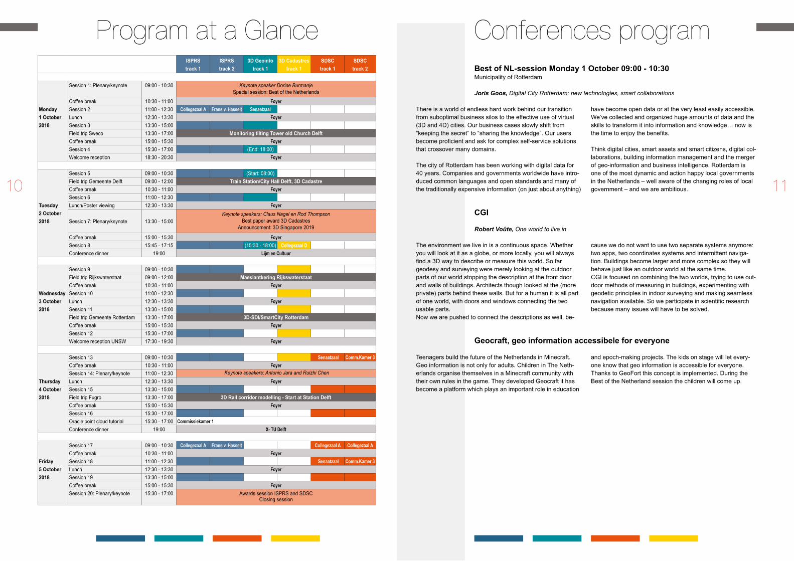
Program at a Glance ISPRStrack 1
ISPRStrack 2
3D Geoinfotrack 1
3D Cadastrestrack 1
SDSCtrack 1
SDSC track 2
Monday 1 October 2018
Session 1: Plenary/keynote 09:00 - 10:30 Keynote speaker Dorine BurmanjeSpecial session: Best of the Netherlands
Coffee break 10:30 - 11:00 FoyerSession 2 11:00 - 12:30 Collegezaal A Frans v. Hasselt SenaatzaalLunch 12:30 - 13:30 FoyerSession 3 13:30 - 15:00 Field trip Sweco 13:30 - 17:00 Monitoring tilting Tower old Church DelftCoffee break 15:00 - 15:30 FoyerSession 4 15:30 - 17:00 (End: 18:00)Welcome reception 18:30 - 20:30 Foyer
Tuesday 2 October 2018
Session 5 09:00 - 10:30 (Start: 08:00)Field trip Gemeente Delft 09:00 - 12:00 TrainStation/CityHallDelft,3DCadastreCoffee break 10:30 - 11:00 FoyerSession 6 11:00 - 12:30 Lunch/Poster viewing 12:30 - 13:30 Foyer
Session 7: Plenary/keynote 13:30 - 15:00Keynote speakers: Claus Nagel en Rod Thompson
Best paper award 3D CadastresAnnouncement: 3D Singapore 2019
Coffee break 15:00 - 15:30 FoyerSession 8 15:45 - 17:15 (15:30 - 18:00) Collegezaal DConference dinner 19:00 Lijm en Cultuur
Wednesday 3 October 2018
Session 9 09:00 - 10:30Field trip Rijkswaterstaat 09:00 - 12:00 Maeslantkering RijkswaterstaatCoffee break 10:30 - 11:00 FoyerSession 10 11:00 - 12:30Lunch 12:30 - 13:30 FoyerSession 11 13:30 - 15:00Field trip Gemeente Rotterdam 13:30 - 17:00 3D-SDI/SmartCity RotterdamCoffee break 15:00 - 15:30 FoyerSession 12 15:30 - 17:00Welcome reception UNSW 17:30 - 19:30 Foyer
Thursday 4 October 2018
Session 13 09:00 - 10:30 Senaatzaal Comm.Kamer 3Coffee break 10:30 - 11:00 FoyerSession 14: Plenary/keynote 11:00 - 12:30 Keynote speakers: Antonio Jara and Ruizhi ChenLunch 12:30 - 13:30 FoyerSession 15 13:30 - 15:00 Field trip Fugro 13:30 - 17:00 3D Rail corridor modelling - Start at Station DelftCoffee break 15:00 - 15:30 FoyerSession 16 15:30 - 17:00 Oracle point cloud tutorial 15:30 - 17:00 Commissiekamer 1Conference dinner 19:00 X- Tu Delft
Friday 5 October 2018
Session 17 09:00 - 10:30 Collegezaal A Frans v. Hasselt Collegezaal A Collegezaal ACoffee break 10:30 - 11:00 FoyerSession 18 11:00 - 12:30 Senaatzaal Comm.Kamer 3Lunch 12:30 - 13:30 FoyerSession 19 13:30 - 15:00 Coffee break 15:00 - 15:30 FoyerSession 20: Plenary/keynote 15:30 - 17:00 Awards session ISPRS and SDSC
Closing session
1110

THURSDAY 4 OCTOBER 11:00 – 12:30:RUIZHI CHEN AND ANTONIO JARA
Ruizhi ChenSmartphonepositioningand3DMappingIndoors
Dr. Ruizhi Chen is currently the Director of the State Key Laboratory of Information Engineering in Surveying, Mapping and Remote Sensing, Wuhan University. He used to work an Endowed Chair and Professor in Texas A&M University Corpus Christ, U.S. and Head & Professor of the Department of Navigation and Posi-tioning at the Finnish Geodetic Institute, Finland. He has published two books: Geospatial Computing in Mobile Devices and Ubiquitous Positioning and Mobile Location-Based Services in Smart Phones. He is an author/co-author of more than 170 scientific papers and 5 book chapters. His research results have been selected twice as cover stories in “GPS Worlds”. His Ph.D. students have received 7 inter-national student paper awards, including 3 times of student-wining papers in the Institute of Navigation for 2010, 2012 and 2013. Dr. Chen is the general chair of the IEEE conferences “Ubiquitous Positioning, Indoor Navigation and Location-based Services” Editor-in-Chief the Journal of Global Positioning Systems and associate editor of the Journal of Navigation. Dr. Chen was the President of the International Association of Chinese Professionals in Global Positioning Systems (2008) and board member of the Nordic Institute of Navigation (2009-2012). Dr. Chen’s research interests include smartphone positioning indoors/outdoors, context awareness and satellite navigation. Antonio JaraSmartDestinations:challengesandopportunitiestocreatesustainablesmartcities in the data economy
Antonio J. Jara (CEO), founder of HOP Ubiquitous S.L. (www.hopu.eu), vice-chair of the IEEE Communications Society Internet of Things Technical Committee, and adjoint scientifique in the University of Applied Sciences Western Switzerland. He did his PhD (Cum Laude) at the University of Murcia (UMU), Spain. These PhD res-ults present a novel way to connect objects to Internet-enabled platforms in an easy, secure and scalable way. He also carried out a MBA and entrepreneurship forma-tion in the ENAE business school and UCAM (2012). He received entrepreneurship awards from ENAE (sponsored by SabadellCAM financial services), emprendeGo (sponsored by Spanish government), IPSO Alliance Award (Sponsored by Google) for its disruptive innovation in the IoT, selected and mentored by the acceleration program FABULOUS (part of the FIWARE EU project). Antonio Jara as part of HOP Ubiquitous is focused on the Smart Cities market with solutions for citizens engagements, tourism, active participation, physical web and environmental monitoring (air quality sensors) in projects such as ENIAC SAFESENS, interoperability / pilots (SmartSDK, Synchronicity, Organicity, BeinCPPS) and also in several actions related to security/privacy (INPUT and FORTIKA). Antonio Jara has also participated in over 100 international events about Internet of Things as Speaker, over 100 international publications / papers (~2700 citations and impact factor h=28), he holds several patents in the IoT domain and finally he has advised in the IoT domain to companies such as Microsoft and Fujitsu.
MONDAY 1 OCTOBER 9:10 – 9:35: DORINE BURMANJE
Dorine BurmanjeNewDimensions,BetterInformation
Keynotes
RodThompson3DCadastres:30yearsback,30yearsahead
TUESDAY 2 OCTOBER 13:30 – 15:00: CLAUS NAGEL AND ROD THOMPSON
Claus Nageluse Cases of 3D City Information Models
Dr. Claus Nagel is CTO of the company virtualcitySYSTEMS GmbH located in Ber-lin, Germany. virtualcitySYSTEMS is a leading expert in the field of 3D city model-ling and provides software solutions for the management, distribution, web-based presentation as well as analysis and simulation of massive 3D geo data based on open standards and interfaces. Dr. Claus Nagel graduated as Master of Science at the University of Applied Sciences Karlsruhe in 2007, and worked on early methods for the conversion from BIM/IFC to OGC CityGML in his Master’s thesis. From 2007 to 2013, he was research assistant in the research group of Prof. Dr. Thomas H. Kolbe at the Institute for Geodesy and Geoinformation Science at Technische Uni-versität Berlin. In his PhD thesis “Spatio-Semantic Modelling of Indoor Environments for Indoor Navigation”, Dr. Nagel presented a framework for the representation of indoor spaces addressing indoor navigation challenges such as context-aware path planning, localization, tracking and guidance. Concepts of this research work were adopted for the OGC IndoorGML standard. Since 2008, he is vice chair of the CityGML Standards Working Group at OGC and co-editor of the CityGML and IndoorGML standards. Dr. Nagel is a core developer and head of the steering group of the open source CityGML database solution 3D City Database.
Dorine Burmanje is the CEO of Kadaster, the Netherlands’ Cadastre, Land Registry and Mapping Agency which collects and registers administrative and spatial data on property and the rights involved. This also goes for ships, aircraft and telecom networks. Doing so, Kadaster protects legal certainty. Kadaster is also responsible for national mapping and maintenance of the national reference coordinate system. Furthermore, it is an advisory body for land-use issues and national spatial data infrastructures. Dorine Burmanje’s international orientation is reflected in her active involvement as Co-Chair of the United Nations initiative on Global Geospatial Information Manage-ment (UN-GGIM).
In the early 1980’s, Rod Thompson was presented with a challenge. The Depart-ment of Mapping and Surveying was in the process of capturing the cadastral maps for the state of Queensland in digital form. The challenge was what to do with the data – how and where to store it, and how to make it accessible. He implemented a 2D+t solution using a relational database, which at the time was counter to conven-tional wisdom, but is now considered “best practice”. This began an interest he still has in the storage and representation of spatial data, leading to a PhD, and con-tinuing research in the field. He is active in the 3D Cadastral research community through Delft University of Technology and the University of Southern Queensland. He is author (or co-author) of large number of publications, of which 25 are associ-ated with the storage of Cadastral data.
1312

Sweco: Monitoring tilting Old Church DelftMonday 1 October 2018, 13:30 - 17:00Max 25 participantsRegistration fee: € 25,00 Meeting point:LobbyTUDelftAulaCongressCentre.Transportationwillbearranged.Departuretime:13:30
The tower of the Oude Kerk was built at the end of the 13th century on a subdued part of the canal. Already during con-struction, the tower collapsed, after which the builders have finished the tower as much as possible. The tilt is currently almost 3 m at the tip of the tower. The municipality of Delft is the manager of the tower and has been commissioned by TNO and Deltares to conduct re-search into the stability of the tower. This has shown that the tower can remain in motion for centuries, with the inclination increasing even further. Sweco has been carrying out meas-urements since 2001 to monitor the tilt.During the construction of the railway tunnel in Delft, at 140 m distance, the tower fell outside the area that was monitored by the contractor. That is why the monitoring of the inclined position has been intensified by the use of continuous meas-uring systems. With sensors, Sweco measures the inclination and setting of the tower every ten minutes with high accuracy, to signal changes in the dislocation movement early and thus inform the municipality about the condition of the tower.
MunicipalityDelft,Spoorzone/3DCadastreTuesday 2 October 2018, Tuesday, 9:00-12:00Max 25 participantsRegistration fee: € 25,00
Meeting point: LobbyTUDelftAulaCongressCentre.Transportationwillbearranged.Departuretime:08:45
We will take you to the heart of the Delft Railway Area project (“Spoorzone Delft”), the new building of the combined railway station/municipal offices of the city of Delft. TU Delft and the Dutch Cadastre carried out a pilot in 2016 in which the 3D map of the new building was registered with the Cadastre. Never before had a three dimensional map been legally registered. The building ownership is with three different proprietors and covers a relatively small surface. This made the structure uniquely suitable for the pilot. During the excursion a present-ation will be given about the pilot, followed by a tour of the municipal offices and the new railway station, including the underground bicycle park for 5000 bicycles and the railway platforms in the tunnel.
Rijkswaterstaat,MaeslantkeringDatalabWednesday 3 October 2018, 8:30 - 12:30Max 35 participantsRegistration fee: € 25,00
Meeting point: LobbyTUDelftAulaCongressCentre.Transportationwillbearranged.Departuretime:8:30
The Maeslantkering is a storm surge barrier on the Nieuwe Waterweg, Netherlands, controlled by a supercomputer. It closes if the city of Rotterdam is threatened by floods and is part of the Delta Works. It is one of largest moving structures on Earth, rivalling the Green Bank Telescope in the United States and the Bagger 288 excavator in Germany. On 10 May 1997, after six years of construction, Queen Beatrix opened the Maeslantkering. The Maeslantkering is expected to be closed once every ten years due to a storm surge. The barrier is closed for testing once a year, usually in the end of September or the beginning of October, just before the beginning of the storm season mid-October. The software that drives it is written in C++ and consists of 200,000 lines of code for the operational system and 250,000 lines of code for the simulation systems. The barrier is designed to withstand a storm that has an occurrence of only once in 10,000 years.
The program consists of a guided tour at Maeslantkering and a presentation on the Maeslantkering and Datalab.
MunicipalityRotterdam:3D-SDI/SmartCity RotterdamexperienceWednesday 3 October 2018, 14:00 - 17:30 Max 20 participantsRegistration fee: € 25,00Pleasebringyourpassport
Meeting point: LobbyTUDelftAulaCongressCentre.Transportationwillbearranged.Departuretime:13:15
We are happy to welcome you in our modern and innovative city; Rotterdam. During this afternoon we will discuss themes like 3D city modelling, Smart Cities and the merger of geo-in-formation and business intelligence. We will show results, present our vision but will also facilitate discussions, answer questions and we are also curious to learn from your experi-ences! We will provide an informative but informal setting on the 35th floor of our office located in “the Rotterdam”; with 160.000 m2 the largest building in the Netherlands. From here you will have a fantastic panoramic view of the city.
Note: This program will elaborate on the presentation of Joris Goos during the planar program of Geo-Delft entitled: Digital City Rotterdam: new technologies, smart collaborations (Scheduled on Monday morning 1st of October)
High-accuracy3Dmappingofthecompleterailway corridorThursday 4 October 2018, 14:00 - 17:00Max 25 participantsRegistration fee: € 25,00 Meeting point:LobbyTUDelftAulaCongressCentre.Transportationwillbearranged.Departuretime:13:30
With the Rila technology a digital twin of the railinfrastructure can be produced efficiently.Capturing of the data is possible without disturbing the exist-ing train operation. Instead of that, the existing train operation is used.The dataset produced brings the railway to the desktop of rail professionals, giving them the opportunity to engineer and manage the rail assets in the most efficient way.During the excursion the operation op Rila in passenger ser-vice will be demonstrated. The technology used and results will be further explained and presented.
Fieldtrips
1514

ISPRSMONDAY 1 OCTOBER – FRIDAY 5 OCTOBER
Organising Committee
Hussein M. Abdulmuttalib Dubai Municipality, Deira, Dubai UAEGiorgio Agugiaro Austrian Institute of Technology, Vienna, AustriaThomas Blaschke University of Salzburg, Salzburg, AustriaPawel Boguslawski Wroclaw University of Science and Technology, Wroclaw, PolandMartin Breunig Karlsruhe Institute of Technology, Karlsruhe, GermanyMaria Antonia Brovelli Politecnico di Milano, Milan, ItalySidonie Christophe IGN-France, Paris, FranceArzu Coltekin University of Zurich, Zurich, SwitzerlandMahmoud R. Delavar University of Tehran, Tehran, IranMulhim Al Doori American University, Dubai, UAESuzana Dragicevic Simon Fraser University, Burnaby, CanadaEric Guilbert Université Laval, Québec, CanadaJames Haworth University College London, London, United KingdomGuoman Huang Chinese Academy of Surveying and Mapping, Beijing, ChinaUmit Isikdag Mimar Sinan Fine Arts University Istanbul, Istanbul, TurkeyMikhail Kanevski University of Lausanne, Lausanne, SwitzerlandZhizhong Kang China University of Geosciences, Beijing, ChinaKourosh Khoshelham University of Melbourne, Melbourne, AustraliaMila Koeva University of Twente, Enschede, The NetherlandsMargarita Kokla National Technical University of Athens, Athens, GreeceKlaus Komp EFTAS Remote Sensing, Transfer of Technology, Muenster, GermanyBart De Lathouwer Open Geospatial Consortium, Kontich, BelgiumHeather Leason OSM, QatarYaolin Liu Wuhan University, Wuhan, ChinaMarguerite Madden University of Georgia, Athens, Georgia, USAMir Abolfazl Mostafavi Université Laval, Quebec, CanadaGerhard Navratil Technical University Wien, Vienna, AustriaDev Raj Paudyal University of Southern Queensland, Toowoomba, AustraliaGeorge Percivall Open Geospatial Consortium, Maryland, USAMichael Peter University of Twente, Enschede, The NetherlandsChris Pettit University of New South Wales, Sydney, AustraliaGeorge Sithole University of Cape Town, Cape Town, South AfricaSisi Zlatanova University of New South Wales, Sydney, Australia
MONDAY 1 OCTOBER
session 1 PLENARy/KEyNOTE 9:00 – 10:30 Auditorium OPENING / BEST OF NL SESSION
Chair: Peter van Oosterom
WelcomebyISPRSpresidentChristian HeipkeNewDimensions,BetterInformationDorine BurmanjeDigitalCityRotterdam:newtechnologies,smartcollaborationsJoris GoosOne world to live inRobert VoûteGeocraft,geoinformationaccessibleforeveryoneGeo kids
Coffee breAk 10:30 – 11:00 foYer
session 2/1 11:00 – 12:30 CollegezAAl ACOLLABORATIVE CROWDSOuRCED CLOuD MAPPING (WG4)Chair: Maria A Brovelli
EnhancedclassificationmodelformultispectralobservationsfromtheearthIvan E. Villalon-TurrubiatesUAVphotogrammetryforfeatureextractionandmappingofcorrugatedindustrialrooftopsKarun Reuel Dayal and Inder Mohan ChauhanAgrassrootorientedurbanplanningapproachtoupliftthesocio-economicfacetofacityusing2Dand3DGIS:casestudyonMehmedabadCity,IndiaSaurabh Gupta, Chiranjay Shah, Devshri Shah, Prithvi Deore, Sayantan Majumdar, Abhisek Maiti, Shashwat Shukla, Jignesh Mehta and Mansi ShahTime-related quality dimensions of urban remotely sensed big dataZsófia Kugler, György Szabó, Hussein Abdulmuttalib, Guoman Huang, Árpád Barsi and Carlo BatiniValidationoftheglobalhigh-resolutionglobeland30landcovermapinEuropeusinglandcoverfieldsurveydatabase–LUCASGorica Bratic, Monia Elisa Molinari and Maria Antonia Brovelli
session 2/2 11:00 – 12:30 frAns vAn HAsseltSPATIALDATAANALySIS,STATISTICSANDUNCERTAINTyMoDELLING(WG3)Chair: Gerard Heuvelink
Keynote:QualityassessmentofgeospatialbigdatawithouttraditionalreferencedataJohn ShiDefinitionofcontourlinesinterpolationoptimalmethodsfore-GovermentsolutionsAlexey Noskov and Alexander ZipfQualityassessmentofanextendedinterferometricradardataprocessingapproachWinhard TampubolonPrototypeofnationaldigitalelevationmodelinIndonesiaDanang Budi Susetyo, Yustisi Ardhitasari Lumban Gaol and Ibnu Sofian
lunCH 12:30 – 13:30 foYer
session 3/1 13:30 – 15:00 CollegezAAl AWORKSHOP: CAPACITy BuILDING ISPRS CHALLENGE (WG4)Theme:CapacityBuildingforHighResolutionLandCoverIntercomparisonandValidation.
The workshop focuses on the presentation of the training/educational material about the intercomparison/validation of global Land Cover maps developed within the ISPRS Capacity Building Initiative. The dataset used in the training is GlobeLand30. Desktop, web and mobile collaborative geospatial applications are presented in the workshop. The training material is immediately reusable, being based on Freeware or Free and Open Source Software (FOSS) and being released under a Creative Commons Attribution 3.0 License (CC BY 3.0). The workshop is open to any participants; no specific or technical background is required.
FullprogrammeISPRS
LINKS TO THE OPEN AND ON-LINE PROCEEDINGS
The ISPRS TC IV ‘Spatial Information sciences’ Symposium (1 – 5 October 2018):l https://www.isprs-ann-photogramm-remote-sens-spatial-inf-sci.net/IV-4/l https://www.int-arch-photogramm-remote-sens-spatial-inf-sci.net/XLII-4/
1716

session 3/2 13:30 – 15:00 frAns vAn HAsselt GEOSPATIAL BIG DATA AND uRBAN STuDIES (ICWG III/IVB AND WG4)Chair: Hussein Mohammed Abdulmuttalib
MigrationofdigitalcartographytoCityGML;aweb-basedtoolforsupportingsimpleETL proceduresFrancesco Pirotti and Francesca FissoreVisualizationonfossil-fuelcarbondioxide(Co2)emissionsfrombuildingsinTokyometropolisRichao Cong, Makoto Saito, Akihiko Ito, Ryuichi Hirata and Shamil MaksyutovDynamicalpredictiontechniqueforGeosimulationusingmultispectralremotesensingdataIvan E. Villalon-TurrubiatesAsemanticgraphdatabaseforBIM-GISintegratedinformationmodelforanintelligenturbanmobilitywebapplicationAbdel-Hadi Hor, Gunho Sohn, Pio Claudio, Afnan Ahmad and Mojgan JadidiAnalysisofthefloatingcardataofTurinpublictransportationsystem:firstresultsRoberta Ravanelli and Mattia Crespi
Coffee breAk 10:30 – 11:00 foYer
session 4/1 15:30 – 17:00 CollegezAAl A WORKSHOP: MAPATHON (WG4)
Theme:openStreetMapmapathon. A step-by-step mapping exercise for beginners, focusing on a humanitarian mapping task proposed by
the Humanitarian OpenStreetMap Team (HOT). HOT coordinates humanitarian mapping in the after-math of disasters and in prevention of humanitarian crises all over the world. A web-based tool created by HOT, the Tasking Manager, will be used during the mapathon. Participants are required to bring their own laptop with wi-fi connection enabled. No specific software will be used during the mapathon; only a browser is required (suggested browsers: Firefox and Chrome).
session 4/2 15:30 – 17:00 frAns vAn HAsseltGLOBAL MAPPING: uPDATING VERIFICATION AND INTEROPERABILITy (ICWG IV/III)Session Chair: Hao WU
Quadtreespatialindexmethodwithinclusionrelationsfortheincrementalupdatingofvectorland cover databaseXiaoguang Zhou and Hongsong Wang AComparisonofgeometriccorrectionschemesforgeostationaryoceanColorimagerslotswithoutGCPsJonghwan Son, Han-Gyeoul Kim and Taejung KimAutomated road breaching to enhance extraction of natural drainage networks from elevation modelsthroughdeeplearningLarry Stanislawski, Tyler Brockmeyer and Ethan ShaversRemotesensinganalyticalgeospatialoperationsdirectlyinthewebbrowserJoan Masó, Alaitz Zabala, Ivette Serral and Xavier PonsImplementingSIFTandBi-triangularplanetransformationforintegratingdigitalterrainmodelsIdo Massad, Sagi Dalyot and Yerach Doytsher
TUESDAY 2 OCTOBER
session 5/1 9:00 – 10:30 CollegezAAl ASPATIALDATAANALySIS,STATISTICSANDUNCERTAINTyMoDELLING(WG3)Session Chair: John Si
Keynote:UncertaintypropagationinspatialmodellingGerard HeuvelinkNewinsightsintosolarwindimplantedvolatilesforlunarregolithcharacterization:asimulationbasedapproachShashwat Shukla, Sayantan Majumdar, Abhisek Maiti and Shashi KumarIntegrationofmultiplecollectedpolygonswitharaster-basedapproachVolker WalterIdentificationofsimilaritiesandpredictionofunknownfeaturesinanurbanstreetnetworkUdo Feuerhake, Oskar Wage, Monika Sester, Nicolas Tempelmeier and Elena Demidova
session 5/2 9:00 – 10:30 frAns vAn HAsseltCOLLABORATIVE CROWDSOuRCED CLOuD MAPPING (WG4)Session Chair: Bert Veneendaal
DeeplearningstudyofextractingnavigationareafromcadblueprintsLei Niu, Yiquan Song, Jie Su and Hongmin Zhang A Thepicturepiletoolforrapidimageassessment:ademonstrationusinghurricaneMatthewOlha Danylo, Inian Moorthy, Tobias Sturn, Linda See, Juan Carlos Laso Bayas, Dahlia Domian, Dilek Fraisl, Cristiano Giovando, Blake Girardot, Ravi Kapur, Pierre Philippe Matthieu and Steffen FritzSolutiontofleetsizeofdocklessbike-sharingstationbasedonmatrixanalysisYong Zhai, Jin Liu, Juan Du and Jie ChenPreliminaryanalysisandcomparisonofthepotentialofVGIavailableinsocialmediaforemer-gencyresponseandmunicipalmanagementCidália C. Fonte, Joaquim Patriarca, Jacinto Estima, José Paulo Almeida and Alberto CardosoUsergeolocatedcontentanalysisforurbanstudies:investigatingmobilityperceptionandhubsusing TwitterMonia Elisa Molinari, Daniele Oxoli, Candan Eylül Kilsedar and Maria Antonia Brovelli
Coffee breAk 10:30 – 11:00 foYer
session 6/1 11:00 – 12:30 CollegezAAl ASDI: INTERNET OF THINGS AND SPATIAL DECISION SuPPORT (WG6)Session Chair: Marguerite Madden
Sponsorpresentation:IoTsupportfordecisionmaking,using3DcitymodelsJan Blaauboer, Bentley SystemsResearch on geometric change detection algorithm for vector surface feature setLining Zhu, Chengming Li, Li Liu, Jianming Shen, Lina Yang and Zhendong LiuAmachinelearningapproachtooccupantnumberpredictionforindoorspacesUmit Isikdag, Kemal Şahin and Sergen CansizUrbantrafficflowanalysisbasedondeeplearningcardetectionfromCCTVimageseriesMaria Valasia Peppa, Daniel Bell, Tom Komar and Wen Xiao
session 6/2 11:00 – 12:30 frAns vAn HAsseltGEOCOMPuTATION AND GEOSIMuLATION (WG8)Session Chair: James Haworth
onaknowledge-basedapproachtotheclassificationofmobilelaserscanningpointcloudsMathias LemmensAnagent-basedmodeltorepresentthespace-timepropagationofforest-firesmokeAlex Smith and Suzana DragicevicInfluenceofword-of-mouthcommunicationonlarge-scaleevacuationafterasevereearthquakeToshihiro Osaragi and Takuya TsuchiyaThecomparisonofdrainagenetworkextractionbetweensquareandhexagonalgrid-basedDEMLu Wang and Tinghua Ai
1918

Streamsdowork:measuringtheworkoflow-orderstreamsonthelandscapeusingpointcloudsEthan Shavers and Lawrence Stanislawski
lunCH 13:30 – 15:00 foYerPOSTER PRESENTATIONS
session 7 13:30 – 15:00 AuditoriumPLENARy SESSION Session Chairs: Mila Koeva / Jantien Stoter
use cases of 3D City Information ModelsClaus Nagel3DCadastres:30yearsback,30yearsaheadRod ThompsonAnnouncement:3DSingapore2019-SingaporeLandAuthority(SLA)andNationalUniversityofSingapore(NUS),Victor Khoo3DCadastresBestpaperAward
Coffee breAk 15:00 – 15:45 foYer
session 8/1 15:45 – 17:15 CollegezAAl ASPATIALDATAANALySIS,STATISTICSANDUNCERTAINTyMoDELLING(WG3)Session Chair: Mahmoud Reza Delavar
IdentificationoflowaccuracyregionsinlandcovermapsusinguncertaintymeasuresandclassificationconfidenceCidália C. Fonte and Luísa M. S. Gonçalves Approachestodistinguish‘real’changesfrom‘unreal’changesbasedonmulti-temporal2DbuildingfootprintdataMartin Schorcht, Robert Hecht and Gotthard MeinelDevelopmentandcomparisonofuncertaintymeasuresintheframeworkofadataclassificationJochen SchiewePlay-basedhydrocarbonexplorationunderspatialuncertaintyusingevidentialtheorySahand Seraj and Mahmoud Reza DelavarAchievingthestateofresearchpertainingtoGISapplicationsforculturalheritagebyasystem-atic literature reviewPatricia Ferreira Lopes
session 8/2 15:45 – 17:15 frAns vAn HAsseltSDI: INTERNET OF THINGS AND SPATIAL DECISION SuPPORT (WG6)Session Chair: Giuseppina Vacca
Sponsorpresentation:RespondEffectively.Pix4DforPublicSafetyFlorian Muehlschlegel, Pix4DNMStream:ascalableevent-drivenETLframeworkforprocessingheterogeneousstreamingdataFei Xiao, Chengming Li, Zheng Wu, Jianming Shen, Lining Zhu and Yinghao Wu
GIS and fuzzy AHP based area selection for electric vehicle charging stationsDogus Guler and Tahsin Yomralioglu operationalnearrealtimericeareamappingusingmulti-temporalsentinel-1SARobservationsJayantrao Mohite, Suryakant Sawant, Abhinav Kumar, Mehul Prajapati, Subhadra Varma Pusapati, Dineshkumar Singh and Srinivasu Pappula
WEDNESDAY 3 OCTOBER
session 9/1 9:00 – 10:30 CollegezAAl ATHEMESESSIoN1:VIRTUAL&AUGMENTEDREALITy:TECHNoLoGy,DESIGN&HUMANFACTORSIn this double-session, we (ISPRS Working Group IV/9) explore the current state of the art in technology, design and human factors knowledge on virtual and augmented reality systems through presentations and moderated discussions. The main objective of the session is to identify the research gaps and discuss the solutions to existing problems.
session 9/2 9:00 – 10:30 frAns vAn HAsseltGEO- DATA MANAGEMENT (WG7)Session Chair: Martin Breunig Workshop: Virtual and Augmented reality (WG9)
ClusteringandindexinghistoricvesselmovementdatawithspacefillingcurvesMartijn MeijersTrajectorycompressionwithconstraintsofroadnetworksLing ZhangEfficientandpracticalhandlingofspatio-temporaldatabasedontime-dependentnet componentsPaul Vincent KuperA6-dimensionalHilbertapproachforindexingfullwaveformlidardatainadistributedcomputingenvironment Anh Vu VoSupportingwideuser-baseinrasteranalysis-GeocubesfinlandLassi Lehto
Coffee breAk 10:30 – 11:00 foYer
session 10/1 11:00 – 12:30 CollegezAAl AWORKSHOP: VIRTuAL AND AuGMENTED REALITy (WG9)Themesession2:Virtual&AugmentedReality:Technology,Design&HumanFactors
In this double-session, we (ISPRS Working Group IV/9) explore the current state of the art in technology, design and human factors knowledge on virtual and augmented reality systems through presentations and moderated discussions. The main objective of the session is to identify the research gaps and dis-cuss the solutions to existing problems.
session 10/2 11:00 – 12:30 frAns vAn HAsseltGEO-DATA MANAGEMENT (WG7)Session Chair: Mulhim Al Doori
Managementoflargeindoorpointclouds:aninitialexplorationHaicheng Liu, Peter van Oosterom, Martijn Meijers and Edward VerbreeAgeospatialanalysisframeworkforfinescaleurbaninfrastructurenetworksQingyuan Ji, Stuart Barr, Phil James and David FairbairnTowardsanintelligentplatformforbig3DgeospatialdatamanagementNima Mazroob Semnani, Paul Vincent Kuper, Martin Breunig and Mulhim Al-DooriIntegratingGISandBIMtosupportthemanagementoflargebuildingstocksGiuseppina Vacca, Emanuela Quaquero, Davide Pili and Mauro BrandoliniA restful API for the extended What3Words encodingWen Jiang and Emmanuel Stefanakis
lunCH 12:30 – 13:30 foYer
session 11/1 13:30 – 15:00 CollegezAAl AMuLTI-DIMENSIONAL MODELLING (WG1)Session Chair: Pawel Boguslawski
BuildingGeneralizationusingDeepLearningMonika Sester, Yu Feng and Frank ThiemannOn volume data reduction for lidar datasetsKazimierz Becek and Pawel Boguslawski
2120
IndoormeshclassificationforBIMLavinia Stefania Runceanu and Norbert HaalaMultilevelsemanticmodellingofurbanbuildingspacebasedonthegeometriccharacteristicsin3D environmentXuan SunThree-DimensionalDataModellingforUndergroundUtilityNetworkMappingJingya Yan, Siow Wei Jaw, Rob Van Son, Kean Huat Soon and Gerhard Schrotte
session 11/2 13:30 – 15:00 frAns vAn HAsseltCOLLABORATIVE CROWDSOuRCED CLOuD MAPPING (WG4)Session Chair: Marco Minghini
ClassificationofbuildingfunctionusingavailablesourcesofVGICidália C. Fonte, Marco Minghini, See Linda, Antoniou Vyron and Patriarca JoaquimLanduseclassificationfromcombineduseofremotesensingandsocialsensingdataAdindha Surya Anugraha and Hone-Jay ChuImprovedclassificationofsatelliteimageryusingspatialfeaturemapsextractedfromsocialmediaArtem Leichter, Dennis Wittich, Franz Rottensteiner, Martin Werner and Monika SesteropensourcesoftwareandopeneducationalmaterialonLandCovermapsintercomparisonandvalidationMaria Antonia Brovelli, Marco Minghini, Monia Elisa Molinari, Candan Eylül Kilsedar, Hao Wu, Xinyan Zheng, Jun Chen and Peng ShuIntegrationofhumanparticipatorysensingandarchivesofremotesensingobservationsforfieldlevelcropphenologyestimationSuryakant Sawant, Jayant Mohite and Srinivasu Pappula
Coffee breAk 15:00 – 15:30 foYer
session 12/1 15:30 – 17:00 CollegezAAl AINDooR/oUTDooRSEAMLESSMoDELLING,LBSANDMoBILITy(WG5)Session Chair: Zhizhong Kang
An evaluation framework for benchmarking indoor modelling methodsKourosh Khoshelham, Ha Tran, Lucia Díaz-Vilariño, Michael Peter, Zhizhong Kang and Debaditya Acharya GeometricalnetworkmodelgenerationusingpointclouddataforindoornavigationMasafumi Nakagawa and Riku Nozaki Indoor semantic segmentation from RGB-D images by integrating fully convolutional network withhigher-ordermarkovrandomfieldJuntao Yang and Zhizhong Kang Towardsautomaticreconstructionofindoorscenesfromincompletepointclouds:doorandwindow detection and regularizationM. Previtali, Lucia Díaz-Vilariño and Marco Scaioni RoomshapesandfunctionalusespredictedfromsparsedataYouness Dehbi, Nazrin Gojayeva, Anna Pickert, Jan-Henrik Haunert and Lutz Plümer
session 12/2 15:30 – 17:00 frAns vAn HAsseltSPATIALDATAANALySIS,STATISTICSANDUNCERTAINTyMoDELLING(WG3)Session Chair: Cidalia Fonte
HistoricalSDI,thematicmapsandanalysisofacomplexnetworkofmedievaltowers(13th-15thcentury)intheMoorishstripPatricia Ferreira-Lopes and Juan Francisco RozalemExploringgeospatialvariationindiabetes-relatedprimaryhealthcareserviceutilisationandpotentiallypreventablehospitalisationsinWesternAustraliaBert Veenendaal, Richard Varhol, Alex Xiao, Colleen Koh, Bella Mai, Yudan Liu and Saleem AshtyAnalysis of uAV image quality using edge analysisPyung-Chae Lim and Taejung KimEnrichmentandpopulationofageospatialontologyforsemanticinformationextractionMargarita Kokla, Vagelis Papadias and Eleni TomaiInformationcontentanalysisfromveryhighresolutionopticalspaceimageryforupdatingspatialdatabaseMehmet Alkan
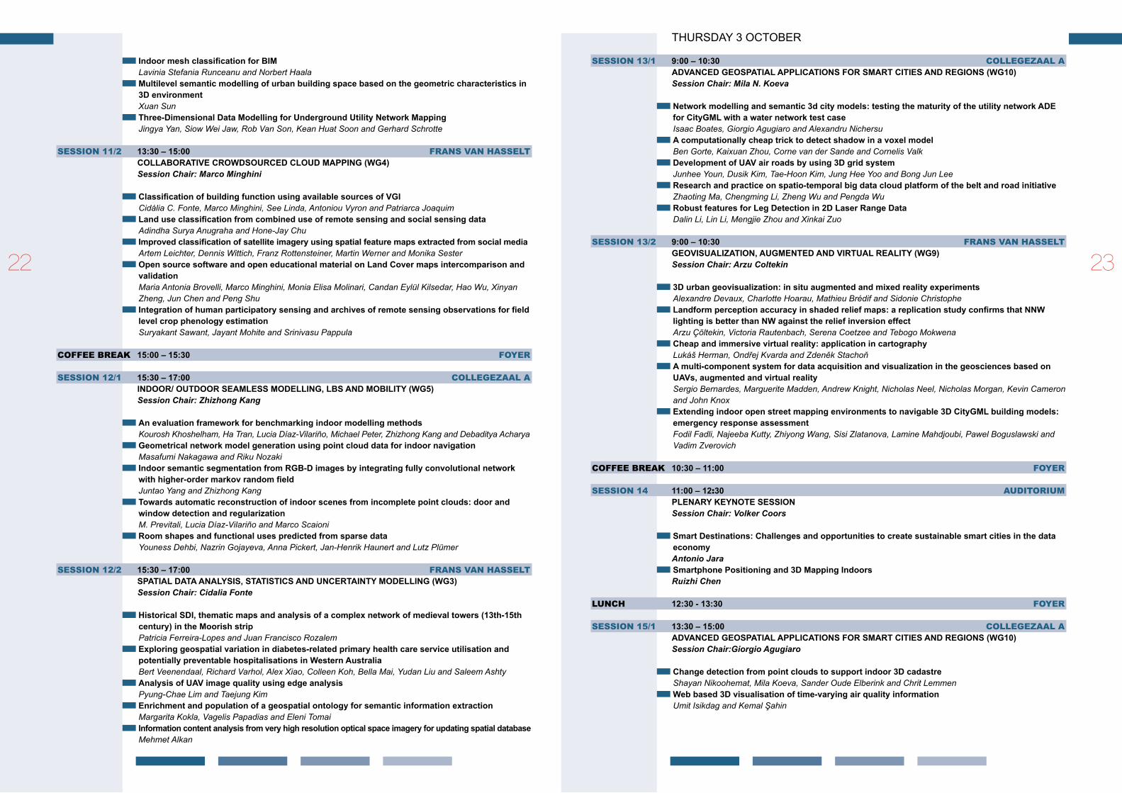
THURSDAY 3 OCTOBER
session 13/1 9:00 – 10:30 CollegezAAl AADVANCED GEOSPATIAL APPLICATIONS FOR SMART CITIES AND REGIONS (WG10)Session Chair: Mila N. Koeva
Network modelling and semantic 3d city models: testing the maturity of the utility network ADE for CityGML with a water network test caseIsaac Boates, Giorgio Agugiaro and Alexandru NichersuAcomputationallycheaptricktodetectshadowinavoxelmodelBen Gorte, Kaixuan Zhou, Corne van der Sande and Cornelis ValkDevelopmentofUAVairroadsbyusing3DgridsystemJunhee Youn, Dusik Kim, Tae-Hoon Kim, Jung Hee Yoo and Bong Jun LeeResearchandpracticeonspatio-temporalbigdatacloudplatformofthebeltandroadinitiativeZhaoting Ma, Chengming Li, Zheng Wu and Pengda WuRobust features for Leg Detection in 2D Laser Range DataDalin Li, Lin Li, Mengjie Zhou and Xinkai Zuo
session 13/2 9:00 – 10:30 frAns vAn HAsseltGEoVISUALIzATIoN,AUGMENTEDANDVIRTUALREALITy(WG9)Session Chair: Arzu Coltekin
3Durbangeovisualization:insituaugmentedandmixedrealityexperimentsAlexandre Devaux, Charlotte Hoarau, Mathieu Brédif and Sidonie ChristopheLandformperceptionaccuracyinshadedreliefmaps:areplicationstudyconfirmsthatNNWlighting is better than NW against the relief inversion effectArzu Çöltekin, Victoria Rautenbach, Serena Coetzee and Tebogo MokwenaCheapandimmersivevirtualreality:applicationincartographyLukáš Herman, Ondřej Kvarda and Zdeněk StachoňAmulti-componentsystemfordataacquisitionandvisualizationinthegeosciencesbasedonUAVs,augmentedandvirtualrealitySergio Bernardes, Marguerite Madden, Andrew Knight, Nicholas Neel, Nicholas Morgan, Kevin Cameron and John KnoxExtendingindooropenstreetmappingenvironmentstonavigable3DCityGMLbuildingmodels:emergencyresponseassessmentFodil Fadli, Najeeba Kutty, Zhiyong Wang, Sisi Zlatanova, Lamine Mahdjoubi, Pawel Boguslawski and Vadim Zverovich
Coffee breAk 10:30 – 11:00 foYer
session 14 11:00 – 12:30 AuditoriumPLENARy KEyNOTE SESSIONSession Chair: Volker Coors
SmartDestinations:ChallengesandopportunitiestocreatesustainablesmartcitiesinthedataeconomyAntonio JaraSmartphonePositioningand3DMappingIndoorsRuizhi Chen
lunCH 12:30 - 13:30 foYer
session 15/1 13:30 – 15:00 CollegezAAl AADVANCED GEOSPATIAL APPLICATIONS FOR SMART CITIES AND REGIONS (WG10)Session Chair:Giorgio Agugiaro
Changedetectionfrompointcloudstosupportindoor3DcadastreShayan Nikoohemat, Mila Koeva, Sander Oude Elberink and Chrit LemmenWeb based 3D visualisation of time-varying air quality informationUmit Isikdag and Kemal Şahin
2322

UrbanmicroclimateimprovementusingENVI-METclimatemodelEfi Chatzinikolaou, Christos Chalkias and Efi DimopoulouC-AQM: A crowdsourced air quality monitoring systemM. Eulàlia Parés Calaf and Francisco Vázquez-GallegoMicroclimate analysis of different urban forms in cold climates and the effect of thermal comfortDogan Dursun and Merve Yavas
session 15/2 13:30 – 15:00 frAns vAn HAsseltGEoVISUALIzATIoN,AUGMENTEDANDVIRTUALREALITy(WG9)Session Chair: Chris Pettit
ImplementingaugmentedrealitysandboxinGeodesign:afutureforGeodesignAida Afrooz, Hrishikesh Ballal and Christopher Pettit Evaluatingroutelearningperformanceofolderandyoungeradultsindifferently-designedvirtualenvironments: a task-differential analysisIsmini Eleni Lokka and Arzu Çöltekin Geogameonthepeat:designingeffectivegameplayinGeogamesappforhazemitigationTrias Aditya and Dany Laksono Towards“tourismforall”-improvingmapsforpersonswithreducedmobilityJoanna Nowak Da Costa and Conrad BielskiEffectivecartographicmethodsforassistingtacticschoiceandindoordeploymentsduringbuildingfires-acasestudytoaidtheDutchfirebrigadeTom van der Meer, Edward Verbree and Peter van Oosterom
Coffee breAk 15:00 – 15:30 foYer
session 16/1 15:30 – 17:00 CollegezAAl AADVANCED GEOSPATIAL APPLICATIONS FOR SMART CITIES AND REGIONS (WG10)Session Chair: Francesco Pirotti
Traveltimeestimationusingspatio-temporalindexbasedonCassandraZheng Wu, Chengming Li, Yinghao Wu, Fei Xiao, Lining Zhu and Jianming ShenAccessibilityassessmentofemergencyvehiclesinTokyometropolitanareaafteralargeearth-quakeMaki Kishimoto and Toshihiro OsaragiGeospatialdataforenergyefficiencyandlowcarboncities-overview,experiencesandnewperspectivesAnna Nowacka and Fabio RemondinoLinkinginteractiveoptimizationforurbanplanningwithasemantic3DcitymodelNils Schüler, Giorgio Agugiaro, Sébastien Cajot and François MaréchalFirststepstowardslinkingsemantic3Dcitymodellingandmulti-domainco-simulationforenergy modelling at urban scaleEdmund Widl, Giorgio Agugiaro and Pablo Puerto
session 16/2 15:30 – 17:00 frAns vAn HAsseltoNToLoGIES,SEMANTICSANDKNoWLEDGEREPRESENTATIoNFoRGEoSPATIAL INFORMATION (WG2)Session Chair: Margarita Kokla
The Maasai of Southern Kenya Domain Model of Land useMina Karamesouti, Carl Schultz, Malumbo Chipofya, Sahib Jan, Cristhian Eduardo Murcia Galeano, Angela Schwering and Christian TimmEnrichmentandPopulationofaGeospatialontologyforSemanticInformationExtractionMargarita Kokla, Vagelis Papadias and Eleni TomaiSemanticLinkingSpatialRDFDatatoTheWebDataSourcesDeniztan Ulutas Karakol, Gulten Kara, Cemre Yilmaz and Cetin ComertAproposaltouseSemanticWebTechnologiesforimprovedroadnetworkinformationexchangeMichael G. Niestroj, David A. McMeekin, Petra Helmholz and Michael KuhnHigh-Level-of-DetailSemantic3DGISforRiskandDamageRepresentationofArchitecturalHeritageElisabetta Colucci, Francesca Matrone, Francesca Noardo, Antonia Spanò and Andrea Lingua
FRIDAY 5 OCTOBER
session 17/1 9:00 – 10:30 CollegezAAl AOPEN GEOSPATIAL STANDARDS
OGC-SDSC-ISPRSSession Chair: Bart de Lathouwer
TheuseofoGC-standardsina3DproductionenvironmentRob van Welsenaere (Avineon)FromspacegeodeticstoappliedgeomaticsEsteban Aguilera (Sensar)Interoperablevisualizationof3DcitymodelsusingoGC’sstandard3dportrayalserviceAthanasios Koukofikis, Volker Coors and Ralf GutbellImprovementsinautomatedderivationofoWLontologiesfromgeospatialUMLmodelsKnut JetlundI3SSceneLayers,StreamingLargeHeterogeneous3DDatasetsSeán William Morrish
session 17/2 9:00 – 10:30 frAns vAn HAsseltIndoor/outdoorSeamlessModelling,LBSandMobility(WG5)
Session Chair: Lucía Díaz Vilariño
Anextractionapproachofthetop-boundedspaceformedbybuildingsforpedestriannavigationJinjin Yan, Abdoulaye Diakité and Sisi ZlatanovaIndoorspaceroutinggraphs:visibility,encoding,encryptionandattenuationGeorge Sithole Indoorrouteplanningunderhexagonnetworkconsideringmulti-constrainsWeicai Wang, Tinghua Ai and Chongya Gong Scanplanningandrouteoptimizationforcontrolofexecutionofas-designedBIMLucía Díaz-Vilariño, Ernesto Frías, Jesus Balado Frias and Higinio Gonzalez-Jorge TheglobaloptimalplacementofBLEbeaconforlocalizationbasedonindoormapRuan Ling, Ling Zhang and Yi Long
Coffee breAk 10:30 – 11:00 foYer
session 18/1 11:00 – 12:30 CollegezAAl AMuLTI-DIMENSIONAL MODELLING (WG1)Session Chair: Eric Guilbert
DetectionandEvaluationofTopologicalConsistencyinCityGMLDatasetsAnna Katarina Giovanella, Patrick Erik Bradley and Sven WursthornTowardsgeneratingsemantically-richIndoorGMLdatafromArchitecturalplansSrishti Srivastava, Nishith Maheshwari and K S RajanModelingcitiesfor3DGISpurposesElaine Gomes Vieira de Jesus, Arivaldo Leão de Amorim, Natalie Johanna Groetelaars and Vivian de Oliveira FernandesThalwegdetectionforrivernetworkcartographyinforestfromhigh-resolutionlidardataEric Guilbert, Sylvain Jutras and Thierry BadardData integration of different domains in geo-information management: a railway infrastructure case studyManuela Corongiu, Grazia Tucci, Enzo Santoro and Olympia Kourounioti
session 18/2 11:00 – 12:30 frAns vAn HAsseltINDooR/oUTDooRSEAMLESSMoDELLING,LBSANDMoBILITy(WG5)Session Chair: Sagi Dalyot
UsingthecombinedLADM-IndoorGMLmodeltosupportbuildingevacuationAbdullah Alattas, Peter Van Oosterom van Oosterom, Sisi Zlatanova, Dick Hoeneveld and Edward Verbree
2524

Frompointcloudsto3DIsovistsinindoorenvironmentsLucía Díaz-Vilariño, Luis Miguel González-Desantos, Edward Verbree, Gina Michailidou and Sisi Zlatanova Image-basedmethodforthepairwiseregistrationofmobilelaserscanningpointcloudsAntria Christodoulou and Peter van Oosterom Highaccuratepointwise(geo-)referencingofaK-TLSbasedmulti-sensor-systemJens Hartmann, Philipp Trusheim, Hamza Alkhatib, Jens-André Paffenholz, Dmitri Diener and Ingo Neu-mann DesignandimplementationofdynamicupdatesystemforgeographicalnamesandaddressesYang Liu, Wei Sun, Chengming Li, Xiaoli Liu and Chiyu Fang
lunCH 12:30 – 13:30 foYer
session 19/1 13:30 – 15:00 CollegezAAl AMuLTI-DIMENSIONAL MODELLING (WG1)Session Chair: Umit Isikdag
openAgentbasedRunoffandErosionSimulation(oARES):AGenericCrossPlatformToolforSpatio-TemporalWatershedMonitoringusingClimateForecastSystemReanalysisWeatherDataSayantan Majumdar, Shashwat Shukla and Abhisek MaitiTowardsascaledependentframeworkforcreatingvario-scalemapsMartijn Meijers, Peter van Oosterom, Radan Šuba and Dongliang PengObject-core oriented data modelling for tracking behaviours of urban heat islandsRui Zhu, Éric Guilbert and Man-Sing WongComparingstereoimagematchingperformancebymulti-dimensionalsearchwindowsSooahm Rhee, Soohyeon Kim, Hee-Ran Ahn and Taejung Kim
session 19/2 13:30 – 15:00 frAns vAn HAsselt
oNToLoGIES,SEMANTICSANDKNoWLEDGEREPRESENTATIoNFoRGEoSPATIAL INFORMATION (WG2)Session Chair: Mir Abolfazl Mostafavi
BootstrappedCNNsforBuildingSegmentationonRGB-DAerialImageryClint Sebastian, Bas Boom, Thijs van Lankveld, Egor Bondarev and Peter H.N. de WithCritical review of the integration of BIM to semantic web technologyBjørn Arild GodagerTowardsanontologyfortheStructurationofRemoteSensingoperationsSharedbyDifferentProcessing ChainsGilles-Antoine Nys, Jean-Paul Kasprzyk, Pierre Hallot and Roland BillenAnalysisofHeavyRainfromTyphoonNumber3(2017)UsingX-BandMultiparameterRadarData,Kyushu,JapanMasahiro Nishio and Masatoshi MoriOverview of standards towards road asset information exchange Michael G. Niestroj, David A. McMeekin and Petra Helmholz
Coffee breAk 15:00 – 15:45 foYer
session 20 15:45 – 16:30 AuditoriumISPRS SCIENTIFIC INITIATIVE AWARDS
Bestpaperaward–SmartDataSmartCities CLOSING
TUESDAY - THURSDAY
Poster PresentAtionsWG1 objectboundariesregularizationusingthedynamicpolylinecompressionalgorithmOmer Saud Azeez, Bahareh Kalantar, Husam Abdulrasool H. Al-Najjar, Alfian Abdul Halin, Naonori Ueda and Shattri MansorWG1 MultigridcellshapeevaluationinDTMfilteringfrommobilelidarpointcloudsLuis Gézero and Carlos AntunesWG3 Quantitative assessment of social vulnerability for landslide disaster risk reduction using GIS approach(casestudy:Cilacapregency,provinceofCentralJava,Indonesia)Arwan Putra Wijaya and Jung-Hong HongWG3 BuildingclassificationofVHRairbornestereoimagesusingfullyconvolutionalnetworksandfreetrainingsamplesYizi Chen, Weixiao Gao, Elyta Widyaningrum, Mingxue Zheng and Kaixuan ZhouWG4 IndoorpositioningusingWLANfingerprintmatchingandpathassessmentwithretroactiveadjustment on mobile devicesEros Gulo, Gunho Sohn and Afnan AhmadWG5 ThepathfromBIMtoa3Dindoorframework-arequirementanalysisLiu Liu, Bofeng Li, Sisi Zlatanova and Hua LiuWG5 3DgeospatialindoornavigationfordisasterriskreductionandresponseinurbanenvironmentTarun Ghawana, Mitko Aleksandrov and Sisi Zlatanova WG7 CoastalmappingofJinu-dowithUAVinNakdongriverEsturay,KoreaChang Ill Yoo, Yoo Sang Oh and Yeon Jung ChoiWG8 Designandimplementationofreal-timeloganalysissystemofmapworldplatformHongping Zhang, Wei Huang and Jing YangWG8 Efficientandaccuratefusionofmassivevectordataon3DterrainZhendong Liu, Chengming Li, Zhanjie Zhao, Dong Zhang, Fei Wang and Ying WangWG10 AnewhierarchicalclusteringapproachforsparsemobilephonetrajectoriesWeixi Wang, Zhaoliang Luan, Biao He, Xiaoming Li, Dejing Zhang, Zhendong Huang and Wei TuICWG III/IVb and WG 4 EstimatinghourlyPM2.5concentrationsfromHimawari-8AoDoverHubeiprovinceJiangping Chen and Xiao Huang ICWG III/IVb and WG 4 Explorationonquantifyingcarbondioxide(Co2)emissionfromroadtrafficinmegacityRichao Cong, Makoto Saito, Ryuichi Hirata, Akihiko Ito and Shamil MaksyutovICWG IV/III GeospatialdatabaseupdatingsystemwithWMSanddirectconnectionmethodBekir Yuksel and Altan Yilmaz
2726

3D GeoInfoMONDAY 1 OCTOBER AND TUESDAY 2 OCTOBER
Organising Committee
Jantien Stoter (co-chair) Delft University of Technology, the Netherlands Mila Koeva (co-chair) University of Twente, the NetherlandsGiorgio Agugiaro Delft University of Technology, the Netherlands Ken Arroyo Ohori Delft University of Technology, the Netherlands Anna Labetski Delft University of Technology, the Netherlands Stelios Vitalis Delft University of Technology, the Netherlands
Full Programme 3D GeoInfo MONDAY 1 OCTOBER
session 1 9:00 – 10:30 Auditorium OPENING / BEST OF NL SESSION
Chair: Peter van Oosterom
WelcomebyISPRSpresidentChristian HeipkeNewDimensions,BetterInformationDorine BurmanjeDigitalCityRotterdam:newtechnologies,smartcollaborationsJoris GoosOne world to live inRobert VoûteGeocraft,geoinformationaccessibleforeveryoneGeo kids
Coffee breAk 10:30 – 11:00 foYer
session 2 11:00 – 12:30 senAAtzAAlVISuALISATION & DISSEMINATIONSession Chair: Stelios Vitalis, 3D Geoinformation, Delft University of Technology
Communicating Multilevel Evacuation Context using Situated Augmented reality Ian Lochhead and Nick Hedley AnAugmentedViewshedAnalysisofComplex3-dimensionalEnvironmentsChen Shechter, Yarin Puor and Sagi Dalyot optimizedorganizationandAdaptiveVisualizationofComplicatedMountainDisaster3DScenesfor Diverse Terminals Yunhoa Zhang, Jun Zhu, Qing Zhu, Weilian Li, Junxiao Zhang, Mingwei Liu, Yun Li and Bin Feng CombinedVisualExplorationof2DGroundRadarAnd3DPointCloudDataforRoadEnviron-ments Johannes Wolf, Sören Discher, Leon Masopust, Sebastian Schulz, Rico Richter and Jürgen Döllner Visualisation of BIM Through Hololens Panagiotis Karydakis CityGML Restful Web Service: Automatic Retrieval of CityGML Data Based on Their Semantics. Principles,GuidelinesandBldgConceptualdesignIoannis Pispidikis and Efi Dimopoulou A3DTillingSchemeforWebBasedManagementof3DSpatialDataUsingonlyopenSourceComponentsandopenFormatsZiya Usta, Muhammet Emre Yıldırım and Çetin Cömert
lunCH 12:30 – 13:30 foYer
session 3 13:30 – 15:00 senAAtzAAlACQuISITION & RECONSTRuCTION Session Chair: Liangliang Nan, 3D Geoinformation, Delft University of Technology
EnhancingtheResolutionofUrbanDigitalTerrainModelsUsingMobileMappingSystemsYu Feng, Claus Brenner and Monika Sester AssessingtheAccuracyandPrecisionofImperfectPointCloudsFor3DIndoorMappingandModelling Jorge Chen, Keith Clarke and Omar Mora A Photogrammetry-based Structure from Motion Algorithm using Robust Iterative Bundle Adjustment Techniques Styliani Verykokou and Charalabos Ioannidis ASlidingWindowMethodforDetectingCornersofopeningsfromTerrestrialLiDARDataJiaqiang Li, Biao Xiong, Filip Biljecki and Gerhard Schrotter Automatic3DReconstructionofBuildingsRoofTopsinDenselyUrbanizedAreasMaria Gkeli and Charalabos Ioannidis
LINKS TO THE OPEN AND ON-LINE PROCEEDINGS
The 13th International 3D GeoInfo Conference (1 – 2 October 2018):l https://www.isprs-ann-photogramm-remote-sens-spatial-inf-sci.net/IV-4-W6/l https://www.int-arch-photogramm-remote-sens-spatial-inf-sci.net/XLII-4-W10/ 2928

ModellingTreesforVirtualSingapore:FromDataAcquisitiontoCityGMLModelsLike Gobeawan, Ervine Shengwei Lin, Abhishek Tandon, Alex Thiam Koon Yee, Victor Hock Soon Khoo, Sandy Shen Ni Teo, Su Yi, Chi Wan Calvin Lim, Sum Thai Wong, Daniel J Wise, Peng Cheng, Soo Chin Liew, Xiaojing Huang, Qihua Li, Lip Seng Teo, Gyula Szabolcs Fekete and Marton PoloIntegration of Tree Database Derived from Satellite Imagery and LiDAR Point Cloud Data Soo Chin Liew, Xiaojing Huang, Ervine Shengwei Lin, Chenghua Shi, Alex Thiam Koon Yee and Abhishek Tandon
Coffee breAk 15:00 – 15:30 foYer
session 4 15:30 – 16:55 senAAtzAAlEuROSDR/VOLTA SESSION: NMCAS I (3D GEOINFORMATION FOR NATIONAL AND CADASTRAL MAPPING AGENCIES I)Session Chair: Francesca Noardo, 3D Geoinformation, Delft University of Technology
Automated Reconstruction Of 3D Buildings in Historic City Centres from LIDAR Data And 2D BuildingFootprintsJens Ingensand, Marion Nappez, Timothée Produit and Thibaud Chassin HowCan3DGISBeUsedtoBetterStore,IntegrateandCommunicateResultsofEnvironmentalImpactAssessments?Monika Swiderska and Claire Ellul UserRequirementsGatheringforANational3DMappingProductinTheUnitedKingdomKelvin Wong and Claire Ellul AutomatedBuildingDetectioninDensePointCloudandUpdateofopenSourceDataBasesEria Aroni and Charalambos Ioannidis CombiningMethodologicalToolsforTheoptimum3DModellingofNTUACampusIoannis Pispidikis, Eva Tsiliakou, Dimitrios Kitsakis, Katerina Athanasiou, Eftychia Kalogianni, Tassos Labropoulos and Efi Dimopoulou WhatIstheNeedforBuildingParts?-AComparisonofCityGML,INSPIREBuildingandASwedish Building Standard Helen Eriksson, Lars Harrie and Jesper Paasch AnApplicativeApproachforSpatialRelationshipsDeterminationof3DVolumetricParcelsIn3DCadastral Systems Ruba Jaljolie, Yerach Doytsher, Kirsikka Riekkinen and Sagi Dalyot ChallengeswithobstacleDataforMannedandUnmannedAviationAlexandrePetrovsky,MalikDoole,JoostEllerbroek,JaccoHoekstraandFilippoTomasello
sHort breAk 16:55 – 17:00 foYer
session 4+ 17:00 – 18:00 senAAtzAAlEuROSDR/VOLTA SESSION: NMCAS II (3D GEOINFORMATION FOR NATIONAL AND CADASTRAL MAPPING AGENCIES II)Session Chair: Jantien Stoter, 3D Geoinformation, Delft University of Technology
TestingtheImpactof2DGeneralisationon3DCityModels–ExploringAnalysisoptionswithAnOff-the-shelf Software Package Estibaliz Muñumer Herrero, Claire Ellul and Jeremy Morley InvestigatingtheState-of-playofGeoBIMAcrossEuropeClaire Ellul, Jantien Stoter, Lars Harrie, Masoome Shariat, Avril Behan and Maria Pla TestbedforSupportingLifecycle3DGeodataandBIM-dataLars Harrie, Helen Eriksson, Thomas Lithén, Perola Olsson, Jing Sun, Örjan Falk and Väino Tarandi StandAlonePresentation-Satellite,AirborneAndCloseRangePhotogrammetryinHeraclesProject Gabriele Murchio and Cecilia Sciarretta DevelopmentandApplicationsofaNationwideobjectoriented3DDataSetVincent van Altena, Tom Commandeur and Marc Post
TUESDAY 2 OCTOBER
session 5– 8:00 – 9:00 senAAtzAAlMODELLING ISession Chair: Kavisha Kumar, 3D Geoinformation, Delft University of Technology
Floor Plans in CityGML Amol Konde, Helga Tauscher, Filip Biljecki and James Crawford ExploringSchemaMatchingtoCompareGeospatialStandards:ApplicationtoUndergroundutility Networks Jacynthe Pouliot, Suzie Larrivée, Claire Ellul and Alaa Boudhaim AProposalforAnImprovedTransportationModelinCityGMLAnna Labetski, Stefan van Gerwen, Guus Tamminga, Hugo Ledoux and Jantien Stoter Extension and Contextualisation for Linked Semantic 3D Geodata Claudine Métral and Gilles Falquet
sHort breAk 9:00 – 9:05 foYer
session 5 9:05 – 10:30 senAAtzAAlAPPLICATIONS I (GENERAL & HERITAGE)Session Chair: Mila Koeva, ITC, University of Twente
TheRotterdam3DCityModel,frominnovationtoimplementationJane Hermans- van Ree NewApproachestoDataVisualisation,AutomatedobjectRecognitionandUrbanManagementBased on Laser Scanning and Photo Panoramas Katerina Mekhlis AFrameworkforReliableThree-dimensionalUndergroundUtilityMappingforUrbanPlanningRob van Son, Siow Wei Jaw, Jingya Yan, Victor Khoo, Richard Loo, Sandy Teo and Gerhard Schrotter 3DCityModelsandPedestrianFlowDataAnalysisSystemforShoppingStreetRevitalizationEri Kawanago, Koutarou Ishizaki, Nobuaki Nagai and Yuji Yoshimura BIM-GIS Oriented Intelligent Knowledge Discovery Hamid Kiavarz, Mojgan Jadidi, Abbas Rajabifard and Gunho Sohn Increasing Awareness for urban Cultural Heritage Based On 3D Narrative System Benshuo Wang, Gamze Z. Dane and Bauke de Vries TheUrbanHeritageCharacterizationUsing3DGeographicInformationSystems.TheSystemofMedium-sized Cities in Andalusia.Daniel Navas-Carrillo, Blanca Del Espino Hidalgo, Francisco Javier Navarro de Pablos and María Teresa Pérez Cano Globe Based 3D GIS Solutions for Virtual Heritage Andrea Scianna and Marcello La Guardia
Coffee breAk 10:30 – 11:00 foYer
session 6 11:00 – 12:30 senAAtzAAlAPPLICATIONS II (ENVIRONMENT)Session Chair: Giorgio Agugiaro, 3D Geoinformation, Delft University of Technology
TheInfluenceofLevelsofDetail(LoD0-2)AndBufferSizesonParameterEffectivenessforFineDust Distribution Modelling Marc-Oliver Löwner and Yahya Ghassoun Visible Routes In 3D Dense City using Reinforcement Learning Oren Gal and Yerach Doytsher IntegrationofSemantic3DCityModelsAnd3DMeshModelsforAccuracyImprovementsofSolarPotential Analyses Bruno Willenborg, Martin Pültz and Thomas H. KolbeDynamic 3D Visualization of Floods: Case of The Netherlands Kavisha Kumar, Hugo Ledoux and Jantien Stoter Tunnelling-induced Ground Settlement Risk Assessment Based on The Integration of BIM with 3DGeospatialModellingToolsStylianos Providakis, Christopher Rogers and David Chapman AUsabilityEvaluationofA3DMapDisplayforPedestrianNavigationTrias Aditya, Dany Laksono, Heri Sutanta, Nur Izzahuddin and Febrian Fitryanik Susanta
3130
Asbestos Roof Detection in RGB Aerial Imagery Sven Briels UrbanHeatIslandMicro-mappingVia3DCityModelUznir Ujang, Suhaibah Azri, M. Zahir, Alias Abdul Rahman and Tan Liat Choon
lunCH 12:30 – 13:30 foYer
session 7 13:30 – 15:00 AuditoriumPLENARy SESSION Session Chairs: Mila Koeva / Jantien Stoter
use cases of 3D City Information ModelsClaus Nagel3DCadastres:30yearsback,30yearsaheadRod ThompsonAnnouncement:3DSingapore2019-SingaporeLandAuthority(SLA)andNationalUniversityofSingapore(NUS),Victor Khoo3DCadastresBestpaperAward
Coffee breAk 15:00 – 15:30 foYer
session 8 15:30 – 16:55 senAAtzAAlPROCESSINGSession Chair: Ravi Peters, 3D Geoinformation, Delft University of Technology
Topological3DElevationDataInterpolationofASTERGDEMBasedonContinuousDeformationAli Jamali and Francesc Antón Castro ASweep-planeAlgorithmforTheSimplificationof3DBuildingModelsinTheApplicationScenario of Wind Simulations Raul Piepereit, Martina Deininger, Martin Kada, Margitta Pries and Ursula Voß ShapeBasedClassificationofSeismicBuildingStructuralTypesRaphael Sulzer, Pirouz Nourian, Michele Palmieri and Jan van Gemert ContextualClassificationof3DTexturedMeshesforUrbanSceneInterpretationWeixiao Gao, Malgorzata Jarzabek-Rychard, Hugo Ledoux, Thijs van Lankveld, Jantien Stoter and Martin Kada PredictionBasedWorkloadPerformanceEvaluationforDisasterManagementSpatialDatabaseNanna Suryana, Muhamad Syaifur Rokman and Fandy Setio Utomo Segmentation Of 3D Photogrammetric Point Cloud For 3D Building Modelling Emre Özdemir and Fabio Remondino CreatingASimplifiedLargeScale3DModelinPostGISForNoise-calculations,BasedonLidarAnd Cadastral Data Tom van Tilburg ExtractingBuildingFootprintsfromAirborneLidarDataChris Lucas
sHort breAk 16:55 – 17:00 foYer
session 8+ 17:00 – 18:00 senAAtzAAlMODELLING IISession Chair: Ken Arroyo Ohori, 3D Geoinformation, Delft University of Technology
AFrameworkforTheRepresentationofTwoVersionsofA3DCityModelIn4DSpaceStelios Vitalis, Ken Arroyo Ohori and Jantien Stoter UrbanCo2Fab:ComprehensionofConcurrentViewpointsofUrbanFabricBasedonGITJohn Samuel, Sylvie Servigne and Gilles Gesquière InvestigatingInteroperabilityCapabilitiesBetweenIFCAndCityGMLLoD4-RetainingSemanticInformation George Floros, Claire Ellul and Efi Dimopoulou Combining urban Metabolism Methods and Semantic 3D City Models Ihab Hijazi, Vanessa Ebert, Andreas Donaubauer and Thomas Kolbe CellComplexesTopologicalLinksforBuildingsinCityGMLSyahiirah Salleh, Uznir Ujang, Suhaibah Azri and Tan Liat Choon
3D Cadastres TUESDAY 2 OCTOBER – THURSDAY 4 OCTOBER
Program Committee
Peter van Oosterom (Chair), Delft University of Technology, the NetherlandsAlias Abdul-Rahman Universiti Teknologi MalaysiaTrias Aditya Gadjah Mada University, IndonesiaAli Aien University of Melbourne, AustraliaAbdullah Alattas Delft University of Technology, the NetherlandsAlaa Ashmawy American University in Dubai, UAEHelena Aström Boss Federal Office of Topography, SwitzerlandLars Bodum Aalborg University, DenmarkMartin Breunig Karlsruhe Institute of Technology, GermanyFrançois Brochu Laval University, CanadaJarosław Bydłosz AGH University of Science & Technology, PolandVolkan Çağdaş Yildiz Technical University, TurkeyVolker Coors Hochschule für Technik Stuttgart, GermanyYakup Emre Coruhlu Karadeniz Technical University, TurkeySagi Dalyot Israel Institute of Technology, IsraelEfi Dimopoulou National Technical University of Athens, GreeceNeeraj Dixit Survey and Land Registration Bureau, Kingdom of BahrainYerach Doytsher Israel Institute of Technology, IsraelFatih Döner Gümüşhane University, TurkeyJosé-Paulo Duarte de Almeida University of Coimbra, PortugalPaul Egesborg Surveyor General Branch, Natural Resources CanadaElikkos Elia Department of Lands and Surveys, CyprusCorné van Elzakker University of Twente, the NetherlandsDiego Erba Ministry of Urban Development and Housing, EcuadorClaire Galpin International Group of French Land Surveyors, FranceMarc Gervais Laval University, CanadaTarun Ghawana Integrated Spatial Analytics Consultants, IndiaCharisse Griffith–Charles University of the West Indies, Trinidad and TobagoTrent Gulliver Land Information New ZealandRenZhong Guo Urban Planning, Land and Resources Commission of Shenzhen Municipality, ChinaHervé Halbout International Group of French Land Surveyors, FranceJoão Paulo Fonseca Hespanha de Oliveira University of Aveiro, PortugalThea Hilhorst World Bank, USAMike Horhammer Oracle Corporation, USAUmit Isikdag Mimar Sinan Fine Arts University, TurkeyGyula Iván Institute of Geodesy, Cartography & Remote Sensing, HungaryKarel Janecka University of West Bohemia, Czech RepublicLorenz Jenni Agencia de Implementación / BSF Swissphoto, SwitzerlandSaeid Mohsen Kalantari Soltanieh The University of Melbourne, AustraliaEftychia Kalogianni Delft University of Technology, the NetherlandsAbdullah Kara Yildiz Technical University, TurkeySudarshan Karki Queensland Government, AustraliaGili Kirschner Survey of IsraelDimitris Kitsakis National Technical University of Athens, GreeceMila Koeva University of Twente, the NetherlandsThomas Kolbe Technical University of Munich, GermanyYoungho Lee Shingu University, Korea Christiaan Lemmen Kadaster, the NetherlandsMateus Magarotto CICS.NOVA Interdisciplinary Centre of Social Science, PortugalTarja Myllymäki National Land Survey of Finland, FinlandGerhard Navratil Vienna University of Technology, AustriaPeter van Oosterom (Chair) Delft University of Technology, the NetherlandsJesper Paasch Lantmateriet, SwedenJenny Paulsson Royal Institute of Technology, SwedenHendrik Ploeger VU Amsterdam & Delft University of Technology, the NetherlandsJacynthe Pouliot Laval University, Canada
3332
Stella Psomadaki Fugro, the NetherlandsAbbas Rajabifard University of Melbourne, AustraliaSiva Ravada Oracle Corporation, USAMiodrag Roić University of Zagreb, CroatiaFrancis Roy Laval University, CanadaGerda Schennach Bundesamt für Eich- und Vermessungswesen, AustriaMarkus Seifert Bayerische Vermessungsverwaltung, GermanyDavood Shojaei University of Melbourne, AustraliaDavid Siriba University of Nairobi, KenyaKean Huat Soon Singapore Land Authority, SingaporeJantien Stoter Delft University of Technology & Kadaster, the NetherlandsErik Stubkjær Aalborg University, DenmarkMichael Sutherland University of the West Indies, Trinidad and TobagoYoav Tal Survey of IsraelRod Thompson Queensland Government, AustraliaAthina Trakas Open Geospatial Consortium, GermanyAmalia Velasco Spanish Directorate General for Cadastre, SpainNikola Vučić University of Zagreb, CroatiaOkan Yildiz Karadeniz Technical University, TurkeyShen Ying Wuhan University, ChinaSisi Zlatanova University of New South Wales, Australia
Full Programme 3D CadastresTUESDAY 2 OCTOBER
session 7 PLENARy 13:30 – 15:00 AuditoriumPLENARy SESSION Session Chairs: Mila Koeva / Jantien Stoter
use cases of 3D City Information ModelsClaus Nagel3DCadastres:30yearsback,30yearsaheadRod ThompsonAnnouncement:3DSingapore2019-SingaporeLandAuthority(SLA)andNationalUniversityofSingapore(NUS),Victor Khoo3DCadastresBestpaperAward
session 8 15:45 – 17:15 CollegezAAl d3D DATA ACQuISITION AND PROCESS MODELS Session chair: Efi Dimopoulou
Designing a 3D Cadastral System Demonstrator: A Case Study Matthew Smart and Russell PriebbenowLADM-basedCrowdsourced3DCadastralSurveying–PotentialandPerspectivesMaria Gkeli, Chryssy Potsiou and Charalabos IoannidisProcesses in Cadastre: Process Model for Serbian 3D Cadastre Dubravka Sladić, Aleksandra Radulović and Miro GovedaricaInitial3DCadastreRegistrationintheRepublicofCroatiabyCadastralResurveyMario Mađer, Nikola Vučić, Saša Vranić and Miodrag RoićConversionof2DAnalogueCadastralBoundaryPlansinto3DDigitalInformation–problemsandchallenges illustrated by a Swedish case Karolina Larsson, Jesper Paasch and Jenny Paulsson
LINK TO THE OPEN AND ON-LINE PROCEEDINGS
The 6th International FIG Workshop on 3D Cadastres (2 – 4 October 2018):l http://www.gdmc.nl/3DCadastres/workshop2018/programme/
3534
session 12 15:30 – 17:30 CollegezAAl dDEVELOPMENTS IN VARIOuS COuNTRIES Session chair: Karel Janecka
DevelopingSerbian3DCadastreSystem-ChallengesandDirectionsNenad Višnjevac, Rajica Mihajlović, Mladen Šoškić, Željko Cvijetinović, Stevan Marošan and Branislav BajatTheapplicationmodelof3DcadastreinpracticalregistrationforrealestateJiyi Zhang, Gang Li, Youzhi Liu, Pengcheng Yin, Jinyu Yu and Zhifeng ShiAn uniform real-estate registration model for China Shen Ying, Renzhong Guo, Lin Li, Naibin Chen and Yizhen JiaDesign and Determine 3D Cadastral Systems: A Case Study of Turkey Hicret Gursoy Surmeneli and Mehmet Alkan MovingTowardsaFullyoperational3DDigitalCadastre:Victoria,AustraliaDavood Shojaei, Hamed Olfat, Abbas Rajabifard, Mohsen Kalantari and Mark BriffaTowardsLADMVictoriacountryprofile–modellingthespatialinformationMohsen Kalantari and Eftychia Kalogianni
THURSDAY 4 OCTOBER
session 13 9:00 – 10:30 CollegezAAl d3D AND 4D MODEL VISuALIZATION Session chair: Mohsen Kalantari
DigitalCartographicModelof3DCadastre:AnInitialDesignandImplementationChen Wang and Chang-bin Yu FromFloorPlanstoCondominiumRightsThroughanAugmentedRealityApproachGerhard Navratil, Marco Schwai, Stefan Vollnhofer, Philip Konturek and Ioannis Giannopoulosusability testing of a web-based 3D Cadastral visualization system Barbara Cemellini, Rod Thompson, Peter van Oosterom and Marian de Vries3DDataforBetterPropertyValueEstimationinthecontextofLADMValuationInformationModelAbdullah Kara, Peter van Oosterom Volkan Çağdaş, Ümit Işıkdağ and Christiaan LemmenModeling Legal Land Object for water bodies in the context of n-dimensional cadastre Ramiro Alberdi and Diego Erba
Coffee breAk 10:30 – 11:00 foYer
session 14 11:00 – 12:30 AuditoriumPLENARy KEyNOTE SESSIONSession Chair: Volker Coors
SmartDestinations:ChallengesandopportunitiestocreatesustainablesmartcitiesinthedataeconomyAntonio JaraSmartphonePositioningand3DMappingIndoorsRuizhi Chen
WEDNESDAY 3 OCTOBER
session 9 9:00 – 10:30 CollegezAAl dINFRASTRuCTuRE AND uTILITIES 3D LEGAL SPACES Session chair: Rod Thompson
Towards3DUtilityNetworkCadastre:ExtendedSerbianLADMCountryProfileAleksandra Radulović, Dubravka Sladić, Miro Govedarica, Aleksandar Ristić and Dušan JovanovićLayerapproachtoownershipin3Dcadastre–asubwaycaseMarcin Karabin, Dimitrios Kitsakis, Mila Koeva, Gerhard Navratil, Jesper Paasch, Jenny Paulsson, Nikola Vučić, Karel Janečka and Anka LisecArialpowerline3DcadasterRigoberto Moreno Vázquez and Diego ErbaImplementationofthe3DCadastreinIsraelRachel Adi, Anna Shnaidman and Shimon BarazaniInvestigating3Dspatialunit’sasbasisforrefined3DspatialprofilesinthecontextofLADMrevision Eftychia Kalogianni, Efi Dimopoulou, Rod Thompson, Christiaan Lemmen and Peter van Oosterom
Coffee breAk 10:30 – 11:00 foYer
session 10 11:00 – 12:30 CollegezAAl dLEGALSPACES,3DBUILDINGSANDINDooRSession chair: Alias Abdul Rahman
ABIM-DrivenApproachtoManagingCommonPropertieswithinMulti-ownedDevelopmentsBehnam Atazadeh, Abbas Rajabifard, Mohsen Kalantari and Jihye ShinCo-ownershipsharesincondominium–AcomparisonacrossjurisdictionsandstandardsVolkan Çağdaş, Erik Stubkjær, Walter Timo de Vries, Cornelius van der Merwe, Jesper Paasch, Jenny Paulsson, Nadja Schwery, Hendrik Ploeger, Ümit Işıkdağ and Abdullah KaraA framework for assessing cadastral data as a source for 3D indoor modelling Jernej Tekavec and Anka LisecDevelopingadatabasefortheLADM-IndoorGMLmodelAbdullah Alattas, Peter van Oosterom, Sisi Zlatanova, Abdoulaye A. Diakité and Jinjin YanINTERLIS3developmentswith3Ddatatypesandbetterconstraintsupportfor3DCadastresMichael Germann, Jürg Lüthy and Peter van Oosterom
lunCH 12:30 – 13:30 foYer
session 11 13:30 – 15:00 CollegezAAl d3D LIFECyCLE: SPATIAL PLANNING – LAND ADMINISTRATION Session chair: Jesper Paasch
Determiningthe“true”environmentalimpactofPublicLawRestrictionsDimitrios Kitsakis and Efi DimopoulouExploring3DCadastresinIndia:EvaluatingthePotentialforLandPlanning,DevelopmentandManagement in Delhi Tarun Ghawana, Rohan Bennett, Jaap Zevenbergen, Pradeep Khandelwal and Subu RahmanDesigningopenSpatialInformationInfrastructureToSupport3DUrbanPlanningInJakartaSmart City Agung Indrajit, Hendrik Ploeger Bastian van Loenen and Peter van Oosterom3DCadastresforComplexExtra-LegalandInformalSituationsCharisse Griffith-Charles and Michael SutherlandContextualisingontologieswithImage,NumberandRationalityKean Huat Soon
Coffee breAk 15:00 – 15:30 foYer
3736

Smart Data Smart CitiesTHURSDAY 4 OCTOBER AND FRIDAY 5 OCTOBER
Program committee
Volker Coors (Chair), HFT Stuttgart, University of Applied Sciences , GermanyClaire Ellul, University College London, UKRobert Laurini, INSA Lyon, FranceMassimo Rumor, University of Padua, ItalySisi Zlatanova, University of New South Wales, Sydney, AustraliaPreston Rodrigues, HFT Stuttgart, University of Applied Sciences, Germany
FullprogrammeSDSCTHURSDAY 4 OCTOBER
session 13 9:00 – 10:30 senAAtzAAlOPENING + 3DSession Chair: Robert Laurini
DefiningSemanticLevelsofDetailsofIndoorMapsJorge ChenModelling Below-and Above-Ground utility Network Features with the CityGML utility Network ADE:ExperiencesfromRotterdamXander den Duijn, Giorgio Agugiaro and Sisi ZlatanovaLinking3DBuildingModels,Maps,andSensorDatainaWeb-basedVisualizationSystemtomonitor Energy-Related DataRosanny Sihombing and Volker Coors
Coffee breAk 10:30 – 11:00 foYer
session 14 11:00 – 12:30 AuditoriumPLENARy KEyNOTE SESSIONSession Chair: Volker Coors
SmartDestinations:ChallengesandopportunitiestocreatesustainablesmartcitiesinthedataeconomyAntonio JaraSmartphonePositioningand3DMappingIndoorsRuizhi Chen
lunCH 12:30 – 13:30 foYer
session 15/1 13:30 – 15:00 CommissiekAmer 3SuSTAINABLE MOBILITySession Chair: Dimos Pantazis
Identifying the Pedestrian Movement Behaviour using the Object Detection Methods and Land-use Agglomeration AnalysisSomsiri Siewwuttanagul, Yukuo Hayashida and Takuro InohaeInferringRoutingPreferencesofBicyclistsfromSparseSetsofTrajectoriesJohannes Oehrlein, Alina Förster, David Schunck, Youness Dehbi, Ribana Roscher and Jan-Henrik HaunertExploringSimilaritiesandVariationsofHumanMobilityPatternsintheCityofLondonPatrizia Sulis and Ed ManleyAnAnalysistoinvestigateSpatialCognitiveFactorswhichInfluenceCyclingPatternsinJohan-nesburgThembani Moyo, Walter Musakwa and Baleseng T Mokoena
session 15/2 13:30 – 15:00 senAAtzAAlDASHBOARDS/WEBGISSession Chair: Alias Rahman
CityProfile:UsingSmartDatatoCreativeDigitalurbanScienceYaxue Ma, Gang Li, Hui Xie and Hudan ZhangGeo-Visualisation and Visual Analytics for Smart Cities: A SurveyShubhi Harbola and Volker CoorsSmartCityWebGISApplications:ProofofWorkConceptforHigh-LevelQuality-of-ServiceAssuranceAlexey NoskovMobilityAtlasBooklet:AnUrbandashboardDesignandImplementationLorenzo Gabrielli, Maria Teresa Rossi, Salvatore Rinzivillo, Daniele Fadda and Fosca Giannotti
Coffee breAk 15:00 – 15:30 foYer
LINKS TO THE OPEN AND ON-LINE PROCEEDINGS
The 3rd International Conference on Smart Data and Smart Cities (4 – 5 October 2018):l https://www.isprs-ann-photogramm-remote-sens-spatial-inf-sci.net/IV-4-W7/l https://www.int-arch-photogramm-remote-sens-spatial-inf-sci.net/XLII-4-W11/ 3938

session 16 15:30 – 17:00 senAAtzAAlTRANSPORTSession Chair: Preston Rodrigues
AdaptiveTrafficLightCycleTimeControllerUsingMicrocontrollersandCrowdscourceDataofGoogleAPIsforDevelopingCountriesSumit Mishra, Devanjan Bhattacharya, Ankit Gupta and Vaibhav SinghShortTermUrbanTrafficForecastingusingDeepLearningGuido Albertengo and Waqar Hassan
TheCo.TR.I.SSystem:TowardsaSmarterCoastalTransportNetworkforSmartIslandsVassilios Moussas, Dimos Pantazis and Panagiotis Stratakis
AmethodtoDefinetheSpatialStationsLocationinaCarsharingSysteminSãoPaulo-BrazilMariana Lage, Claudia Machado, Fernando Berssaneti and José Alberto Quintanilha
FRIDAY 5 OCTOBER
session 17 9:00 – 10:30 CollegezAAl AISPRS,oGCJoINTSESSIoNSession Chair: Bart De Lathouwer
The use of OGC- Standards in a 3D Production EnviromentRob van Welsenaere (avineon)FromSpaceGeodeticstoAppliedGeomaticsEsteban Aguilera (Sensar)InteroperableVisualizationof3DCityModelsusingoGC’sStandard3DPortrayalServiceRalf Gutbell, Volker Coors and Athanasios KoukofikisImprovementsinAutomatedDerivationofoWLontologiesfromGeospatialUMLModelsKnut Jetlund
Coffee breAk 10:30 – 11:00 foYer
session 18/1 11:00 – 12:30 CommissiekAmer 3CITIZEN ENGAGEMENT AND PARTICIPATIONSession Chair: Claire Ellul
ASmartValleyinSouthCatalonia?TheTechno-SymbolicReconstructionofTarragonaCityJosep PuigboComputingFeedbackforCitizens’proposalsinparticipativeUrbanPlanningJens DambruchHotorNot–IdentifyingEmotional“HotSpots”intheCityLara Kohn, Habiburrahman Dastageeri, Thomas Bäumer, Susanne Moulin, Patrick Müller and Volker CoorsADecisionSupportToolonDerelictBuildingsforUrbanRegenerationIvan Blecic, Arnaldo Cecchini, Loredana Tedeschi, Maurizio Minchilli and Giuseppe A. Trunfio
session 18/2 11:00 – 12:30 senAAtzAAlSENSORSSession Chair: Giorgio Agugiaro
Multi-AgentLearningFrameworkforEnvironmentRedundancyIdentificationforMobileSensorsin an IOT ContextDavid Martínez, Eduardo Mojica-Nava, Kym Watson and Thomas UsländerAnultrasonic Sensor for Human Presence Detection to Assist Rescue Work in Large BuildingsTom van Groeningen, Hans Driessen, Jakob Söhl and Robert VoûteIntegrationandVisualizationofHeterogeneousSensorDataandGeospatialinformationThunyathep Santhanavanich, Sven Schneider, Preston Rodrigues and Volker Coors
lunCH 12:30 – 13:30 foYer
session 19 13:30 – 15:00 senAAtzAAluRBAN DECISION MAKINGSession Chair: Robert Laurini
A Novel Model and Tool for Energy Renovation Planning in French Residential Buildings and Districts Kahina Amokrane-Ferka and Amira Ben HamidaCapturingtheSoundsofanUrbanGreenspaceEwan Klein, Simon Chapple, Joachim Fainberg, Cat Magill, Martin Parker, Charles Raab and Jonathan SilvertownDesigningprecintsintheDensifyingCity–TheRoleofPlanningSupportSystemsOri Gudes, Stephen Glackin and Chris PettitInteractiveSpatialWeb-ApplicationsasNewMeansofSupportforUrbanDecision-MakingProcessesErnst Gebetsroither-Geringer, Romana Stollnberger and Jan Peters-Anders
Coffee breAk 15:00 – 15:30 foYer
AwArds session isPrs And sdsC And Closing session
4140

Notes
4342


![Chelsea Flower Show BLOSSOMS & BULBS … · city of Delft, home of Vermeer, and imagine what Amsterdam might have looked like centuries ago. [B] ... BLOSSOMS & BULBS SCANDINAVIA BY](https://img.dokumen.tips/doc/110x75/5f0a827a7e708231d42bfc3a/chelsea-flower-show-blossoms-city-of-delft-home-of-vermeer-and-imagine.jpg)