Embed Size (px)
Citation preview
CONCEPTUAL SCHEME
Rocky View countyDepartment of Planning and community Services
Bylaw ____________, Adopted _______________For Public circulationFebruary 2010


Ro
cky
View
co
un
ty n
o. 4
4By
LAw
___
____
____
____
____

ScH
eDu
Le ‘A
’Fo
RM
inG
PAR
t o
F By
LAw
___
____
____
____
____

Conceptual Scheme Consulting Team:
urban Systems Ltd.
RtkL Associates
carson Mcculloch Landscape Architects
cohos evamy integrated Design
Sass communications inc.
Independent Technical Support:
Mcintosh Lalani engineering Ltd.
Bison Historical Services
Base Property consultants
thomas consultants inc.
waterline Resources inc.

executive Summary
eS-1 Bingham crossing
conceptual Scheme
executive Summary
executive Summary
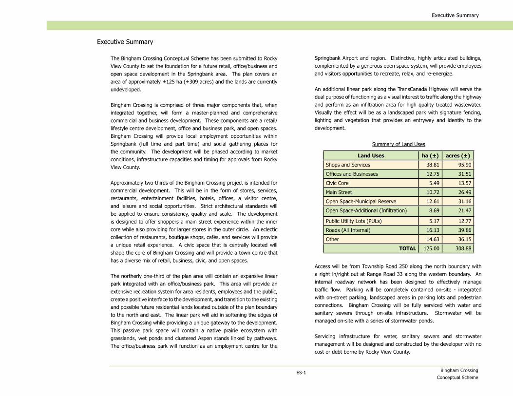
the Bingham crossing conceptual Scheme has been submitted to Rocky View county to set the foundation for a future retail, office/business and open space development in the Springbank area. the plan covers an area of approximately ±125 ha (±309 acres) and the lands are currently undeveloped.
Bingham crossing is comprised of three major components that, when integrated together, will form a master-planned and comprehensive commercial and business development. these components are a retail/lifestyle centre development, office and business park, and open spaces. Bingham crossing will provide local employment opportunities within Springbank (full time and part time) and social gathering places for the community. the development will be phased according to market conditions, infrastructure capacities and timing for approvals from Rocky View county. Approximately two-thirds of the Bingham crossing project is intended for commercial development. this will be in the form of stores, services, restaurants, entertainment facilities, hotels, offices, a visitor centre, and leisure and social opportunities. Strict architectural standards will be applied to ensure consistency, quality and scale. the development is designed to offer shoppers a main street experience within the inner core while also providing for larger stores in the outer circle. An eclectic collection of restaurants, boutique shops, cafés, and services will provide a unique retail experience. A civic space that is centrally located will shape the core of Bingham crossing and will provide a town centre that has a diverse mix of retail, business, civic, and open spaces.
the northerly one-third of the plan area will contain an expansive linear park integrated with an office/business park. this area will provide an extensive recreation system for area residents, employees and the public, create a positive interface to the development, and transition to the existing and possible future residential lands located outside of the plan boundary to the north and east. the linear park will aid in softening the edges of Bingham crossing while providing a unique gateway to the development. this passive park space will contain a native prairie ecosystem with grasslands, wet ponds and clustered Aspen stands linked by pathways. the office/business park will function as an employment centre for the
Springbank Airport and region. Distinctive, highly articulated buildings, complemented by a generous open space system, will provide employees and visitors opportunities to recreate, relax, and re-energize.
An additional linear park along the transcanada Highway will serve the dual purpose of functioning as a visual interest to traffic along the highway and perform as an infiltration area for high quality treated wastewater. Visually the effect will be as a landscaped park with signature fencing, lighting and vegetation that provides an entryway and identity to the development.
Summary of Land uses
Land Uses ha (±) acres (±)
Shops and Services 38.81 95.90
offices and Businesses 12.75 31.51
civic core 5.49 13.57
Main Street 10.72 26.49
open Space-Municipal Reserve 12.61 31.16
open Space-Additional (infiltration) 8.69 21.47
Public utility Lots (PuLs) 5.17 12.77
Roads (All internal) 16.13 39.86
other 14.63 36.15
TOTAL 125.00 308.88
Access will be from township Road 250 along the north boundary with a right in/right out at Range Road 33 along the western boundary. An internal roadway network has been designed to effectively manage traffic flow. Parking will be completely contained on-site - integrated with on-street parking, landscaped areas in parking lots and pedestrian connections. Bingham crossing will be fully serviced with water and sanitary sewers through on-site infrastructure. Stormwater will be managed on-site with a series of stormwater ponds.
Servicing infrastructure for water, sanitary sewers and stormwater management will be designed and constructed by the developer with no cost or debt borne by Rocky View county.

table of contents

Bingham crossing
conceptual Scheme
6.2 internal Road network .........................................................526.3 improvements and Phasing ...................................................54
7.0 PoLicy ReView ..........................................................................607.1 introduction .........................................................................617.2 Rocky View 2060 - Growth Management Strategy ...................617.3 north Springbank Area Structure Plan ....................................647.4 the Municipal Development Plan ...........................................657.5 intermunicipal Development Plan ..........................................677.6 economic Development Strategy ...........................................687.7 calgary Regional Partnership - calgary Metropolitan Plan ........687.8 Summary .............................................................................69
8.0 iMPLeMentAtion .......................................................................708.1 implementation ...................................................................718.2 north Springbank Area Structure Plan Amendment .................718.3 Land use Redesignation........................................................718.4 Phasing and timing ..............................................................73
9.0 PuBLic conSuLtAtion AnD coMMunity inVoLVeMent .............769.1 Public open Houses ..............................................................779.2 Results ................................................................................77
10.0 PoLicy SuMMARy .......................................................................78
11.0 cLoSinG ....................................................................................88
1.0 intRoDuction ..........................................................................11.1 Site History ..........................................................................11.2 conceptual Scheme Purpose .................................................21.3 conceptual Scheme objectives ..............................................2
2.0 PRoject AReA AnD DeScRiPtion ..............................................42.1 Location ..............................................................................52.2 Land ownership ...................................................................92.3 Physical Land Features .........................................................92.4 Background and Supporting Studies ......................................92.5 current Land uses ................................................................112.6 current Adjacent Land uses and Proposed Developments ......................................................................11
3.0 PRoject RAtionALe ..................................................................143.1 Project Vision .......................................................................173.2 Development Guiding Principles ............................................183.3 Project theming and identity ................................................193.4 Leadership in energy and environmental Design (LeeD) ..........203.5 triple Bottom Line Assessment ..............................................213.6 economic impact .................................................................223.7 Social impact .......................................................................233.8 Soil and Land Suitability Assessment......................................233.9 Springbank Airport Master Plan 2009-2029 .............................23
4.0 concePtuAL ScHeMe .................................................................244.1 commercial Development .....................................................274.2 office/Business District .........................................................284.3 Pedestrian circulation ...........................................................294.4 open Spaces........................................................................314.5 civic/Pedestrian core District ................................................374.6 Main Street District ...............................................................384.7 Shops and Services District ...................................................384.8 Architectural Design Guidelines .............................................394.9 interface Approach ...............................................................41
5.0 SeRVicinG AnD utiLitieS ..........................................................425.1 Domestic water Supply .........................................................435.2 wastewater collection, treatment and Disposal ......................465.3 Stormwater Management ......................................................475.4 Shallow utilities ....................................................................485.5 Solid waste Management ......................................................485.6 emergency and Postal Services .............................................49
6.0 tRAnSPoRtAtion.......................................................................506.1 Regional and Local Road network ..........................................51
table of contents
MAPS AnD FiGuReS Figure 2A Rocky View county Location Plan ..................................... 6Figure 2B Aerial Photo.................................................................... 7Figure 2c Legal Base Plan .............................................................. 8Figure 2D Land use Map ................................................................ 12Figure 4A concept Plan .................................................................. 26Figure 4B open Space and Pedestrian circulation Diagram ............... 30Figure 5A conceptual Location for Major water & Sanitary Facilities .. 45Figure 6A Primary Road network circulation Diagram ....................... 53Figure 6B Bingham crossing - Staged transportation improvement ... 55Figure 6c Section at transcanada Highway ..................................... 57Figure 6D Section at Range Road 33 ............................................... 58Figure 6e Section at township Road 250 ......................................... 59Figure 7A Growth Management Strategy Map .................................. 63Figure 8A Proposed Land use Districts ............................................ 72Figure 8B Phasing Plan Diagram ..................................................... 74
(i)

1.0 introduction

1 Bingham crossing
conceptual Scheme
known records of the land
date back to 1887 with
the first homesteader, Mr.
william Bingham.
1.1 Site History
this conceptual Scheme is intended to provide a foundation for the future
land use redesignation and subdivision of lands legally described as the
n½-34-24-3-w5M in Rocky View county containing ±125 ha (±309 acres)
and referred to as “Bingham crossing”. it provides a comprehensive policy
framework intended to guide and evaluate these future applications. it
also addresses details pertaining to servicing (stormwater management,
water servicing and sanitary sewers), open spaces, road linkages and
networks, definition of general future land uses, and development
guidelines.
on june 27, 2006, Rocky View county council directed the applicant
(on behalf of the landowner’s representative) to prepare a conceptual
Scheme for the subject lands. the conceptual Scheme would be adopted
by bylaw, as a prerequisite to any future council consideration(s) of land
use redesignation and subdivision for the lands.
1.1 Site History
known records of the land date back to 1887 with the first homesteader,
Mr. william Bingham, for the northeast quarter. the northwest quarter
was homesteaded by Mr. Howard Dick starting in 1899. in 1902, both
quarters were purchased by Mr. David johnson who built a home on the
site and resided there for several years.
over time, the lands have changed ownership and have always been
used for agricultural activity. the name Bingham crossing is a reflection
of the original homesteader, Mr. william Bingham, for which this project
is named.
introduction

2Bingham crossing
conceptual Scheme
1.2 conceptual Scheme Purpose
the Rocky View Municipal Development Plan (MDP) provides the
foundation for planning matters and directions in Rocky View county. it
allows council to direct applicants to undertake a conceptual Scheme
process to address the future form and function of a proposed plan.
the purpose of a conceptual Scheme is to ensure planning, engineering
and transportation items, and any other elements deemed by council,
are addressed prior to redesignation and subdivision of land. the county
defines a conceptual Scheme as:
“ A conceptual Scheme is not a statutory plan; however one may
be adopted by a council by bylaw in order to relate a subdivision
application to the future subdivision and development of adjacent
lands. A conceptual Scheme also provides policy direction; however
it is the developer’s vision, interests and commitment as to what
they will do which is captured in the policies. in essence conceptual
Schemes provide a much greater level of detail in terms of the
actual subdivision design, site specific technical analysis and how
the proposal will fit in with an area and most importantly relates the
proposed development to the policies of the MDP (or ASP, if one has
been adopted), to illustrate the proposal is in keeping with the overall
Municipal Goals for development within the Municipality.”
Source: Rocky View county website (http://www.rockyview.ca).
1.3 conceptual Scheme objectives
the objective of this conceptual Scheme is to determine the policies and
guidelines appropriate for developing the n½-34-24-3-w5M. this plan
will guide the future redesignation and subdivision of the plan area to
ensure consistency with its directives and the north Springbank Area
Structure Plan (as amended).
on june 27, 2006, a council motion directed the applicant to prepare a
conceptual Scheme document that addresses:
» tHe eXiStinG SituAtion
A baseline description and evaluation of matters such as:
• existing land use
• ownership
• existing development
• Springbank Airport
• topography
• Geotechnical evaluation
• Soils and vegetation
• Agricultural capability
• existing utilities and transportation routes
• Archaeological and historical consideration
• Adjacent land uses
• environmental sensitivity and significance
• Phase 1 environmental site assessment
• Any other matters requested by the municipality
» FutuRe DeVeLoPMent
An evaluation and description of the development within the conceptual
Scheme area relating to the following:
• the intended nature of the development
• the viability of the development
• How the development will contribute to Rocky View county
achieving its strategic goals
• How the development relates to the north Springbank Area
Structure Plan
introduction
1.2 conceptual Scheme Purpose

3 Bingham crossing
conceptual Scheme
introduction
1.3 conceptual Scheme objectives
• How the development will complement and be compatible with
the Springbank Airport Master Plan
• identification of any intermunicipal interests
• How the community will be innovative while efficiently using the
land base
• identification of open spaces and linkages
• identification of land dedication areas such as PuLs, MRs,
easements, etc.
• infrastructure capacity to support the land
• identification of technical development considerations such as
geotechnical evaluation, environmental assessment, historical
overview
• How the development will not adversely affect the viability of
existing uses on adjacent lands
• A utility servicing strategy to identify water supply, sewage
disposal system and solid waste system management
• A stormwater management strategy
• A traffic impact study
• A community services assessment
• Phasing of the development and anticipated build-out
• Addressing on-site and off-site visual impacts
• Location of community mailboxes
• Proposed road names
• consultation directly and indirectly with affected landowners
including a minimum of two public open houses
» ReGionAL MAtteRS
to evaluate and describe the following matters relating to areas outside
of the conceptual Scheme boundary:
• Analysis of the regional transportation network
• Regional socio-economic impacts
• the development’s impacts upon the surrounding north
Springbank community

2.0 Project Area and Description

5 Bingham crossing
conceptual Scheme
within Rocky View county,
the lands are identified
as being in a transition
area. Recent development
approvals and proposals are
contributing to additional
development activity in the
area and the area is viewed
as the gateway to the west.
Project Area and Description
2.1 Location
2.1 Location
the subject lands are located within Rocky View county approximately 4.8
km (three miles) west of the boundary of the city of calgary and adjacent
to the transcanada Highway (see Figure 2A-Rocky View county Location
Plan and Figure 2B-Aerial Photo). the area subject to the conceptual
Scheme is approximately ±125 ha (±309 acres) and currently contains
three single family residences.
the subject lands front onto the transcanada Highway and Range Road
33, which is the crossroad to two significant transportation corridors in
the county. current access to the site is from an existing road allowance
(known as township Road 250) along the entire north boundary of the
plan area which continues to the east and west.
the lands are identified as being in a Major Business corridor (nodal
Development) in the Rocky View county 2060 - Growth Management
Strategy report and is half a mile from the Springbank Airport, a
significant current and proposed employment area in Springbank. Recent
development approvals and proposals for the Harmony project, the
edge School and the Springbank Airport are contributing to additional
development activity in the area. Additional residential developments
proposed or approved in the area, such as Pradera Springs, Springbank
creek and Morgans Rise, will ensure this area functions as a gateway to
the west as it progresses to a diverse economic hub. the combination
of these varied uses will create a focal point that will serve as a landmark
bisecting the mountains and the city of calgary.

Figure 2A: Rocky View county Location Plan
6
Project Area and Description
Bingham crossing
conceptual Scheme
2.1 Location
Source: Rocky View county, 2007

Figure 2B: Aerial Photo
7
Project Area and Description
2.1 Location
Bingham crossing
conceptual Scheme
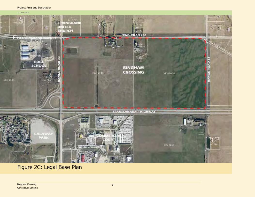
Figure 2c: Legal Base Plan
8
2.1 Location
Bingham crossing
conceptual Scheme
Project Area and Description

9 Bingham crossing
conceptual Scheme
2.2 Land ownership
the lands are currently shown on title as being under the ownership of
Bingham crossing Properties inc.
A summary of the legal descriptions and ownerships is represented in the
table below.
OWNER LEGAL DESCRIPTION
AREA (ha/ac)
Bingham crossing Properties inc.
nw¼-Sec.34-24-3-w5M
61.82 ha (152.98 ac)
Bingham crossingProperties inc.
ne¼-Sec.34-24-3-w5M
60.89 ha (150.59 ac)
Bingham crossingProperties inc.
Ptn. of ne¼-Sec.34-24-3-w5M
2.15 ha (5.30 ac)
TOTAL 124.86 ha (308.87 ac)
Legal descriptions on the plan are shown in Figure 2c–Legal Base Plan.
2.3 Physical Land Features
the conceptual Scheme area is approximately ±125 ha (309 acres) and is
relatively flat. the topography generally slopes from the east to the west
with an overall grade difference of 10 metres. it has been historically
used for agricultural uses, but has limitations regarding its agricultural
viability.
the site generally drains to the northwest and northeast corners.
there are three single family residences on the land, of which one was
constructed in approximately 1915.
Project Area and Description
2.4 Background and Supporting Studies
Several sub-consultant studies have been undertaken in support of
this conceptual Scheme. the complete copies of each study have
been submitted to Rocky View county under separate cover with the
conceptual Scheme application. However, summaries of each study are
provided below.
HiStoRicAL ReSouRceS oVeRView:
Bison Historical Services (December 4, 2006)
A Historical Resources overview (HRo) was completed by Bison
Historical Services. the purpose of the study was to determine the
potential for significant historical items, artifacts and/or events to have
occurred on the subject lands. the HRo undertook a comprehensive
review and concluded that the potential for encountering intact
historical resources on-site is low. the report recommended clearance
for the project and that no additional historical resources impact
assessments are required.
2.2 Land ownership

10Bingham crossing
conceptual Scheme
• identify the strengths and weaknesses of the site
• identify a trade area and the tourist market segment
• Assess the role and function of existing retail centres within the
trade area
• Determine the strategic positioning using the above data and
integrating global retail trends and concepts
• estimate the retail opportunity magnitude (i.e. supportable floor
space) and anchor store functions (such as retail, food/beverage,
entertainment, etc.) to set the stage for the overall development.
BinGHAM cRoSSinG econoMic iMPAct AnALySiS:
thomas consultants inc. (june 4, 2009)
the purpose of this report was to prepare a Retail impact Analysis
for Bingham crossing outlining any economic benefits and market
implications. the site was assessed in terms of:
• employment Generation - through both the development/
construction phases, as well as operating phase
• tax Revenue - for Rocky View county
• Retail Market impact - on the development potential, role and
function of other projects in the surrounding region.
in terms of employment generation, the report anticipates that Bingham
crossing will provide approximately 922 Fte (full time equivalent) jobs
during construction and approximately 1,868 Ftes subsequently for
operating the retail component of the site.
tax generation will benefit Rocky View county to estimated property
tax revenue of $1,448,701/annum for Phase 1. Additional tax benefits
include increased property values and desire/demand to live in an area
that has strong retail amenities.
the report took into consideration the impacts that Bingham crossing
would have on retail projects in proximity to the site, specifically
Harmony (Bordeaux Developments) and Heritage west (taradar
Developments). the retail market impact concludes that there is
PHASe 1 enViRonMentAL Site ASSeSSMent:
Base Property consultants (February 2, 2007)
A Phase one environmental Site Assessment (eSA) was completed by
Base Property consultants. the review considered historical uses on
the site, the possibility for certain contaminants, known environmental
records, and a site visit. the report concluded that no significant
environmental impairment exists on the subject site. the report
also recommended that specific measures be undertaken with future
demolition and clean up of existing buildings.
GeotecHnicAL Site AnALySiS:
Mcintosh Lalani engineering Ltd. (February 2007)
Mcintosh Lalani engineering completed a geotechnical evaluation
for the subject lands to assess the general subsurface soil conditions
and provide geotechnical construction guidelines for the proposed
development. the report concluded that, from a geotechnical
perspective, the lands are suitable for residential and commercial
development.
BinGHAM cRoSSinG RetAiL oPPoRtunity StuDy
- january 2009 update:
thomas consultants inc. (january 30, 2009)
the purpose of this report was to serve as an Appendix to the original
retail study (Springbank Retail opportunity Study) that was completed
in March 2007. this report updated local market conditions related to
new retail development, local market conditions related to new retail
development, new residential development, changes in consumer
expenditure patterns, and demographic trends.
SPRinGBAnk RetAiL oPPoRtunity StuDy:
thomas consultants inc. (March 14, 2007)
the purpose of this report was to identify the retail opportunity for the
proposed site by undertaking the following:
Project Area and Description
2.4 Background and Supporting Studies

11 Bingham crossing
conceptual Scheme
enough residual market for the three developments given reasonable
estimates on sales outflow, capture rates and performance in a partial
build-out in 2014 and full build-out in 2030.
Based on the comprehensive analysis, the report concluded that the
project has the capacity for approximately ±32,516 m2 (±350,000
ft2) of retail, leisure and entertainment uses for its initial Phase 1 of
development. to differentiate itself from competitors in the region, it
was recommended that the project adopt a Retail Village/main street
theme to provide a leisure and destination experience for customers.
Based on the thomas study in the first phase of development, the
project is anticipated to generate approximately $1,448,701 in annual
non-residential property tax for Rocky View county and create
approximately 1,241 jobs.
2.5 current Land uses
the plan area covers the majority of two quarter sections to comprise
approximately 125 ha (309 acres). Most of the plan area is designated as
Ranch and Farm District (RF) and approximately five acres is designated
as Farmstead District (F) and is the location of the existing residence on
the site. the land uses are shown in Figure 2D-Land use Map on Page 12.
2.6 current Adjacent Land uses and Proposed Developments
Adjacent lands on the north side of the transcanada Highway are primarily
residential with Residential two District (R-2) lands to the east of the site
representing residential uses on parcels of a minimum size of 4.0 acres.
Lands to the north of the site are designated as Ranch and Farm District
(RF) with two smaller parcels designated as Agricultural Business District
(B-5) and Agricultural Holdings District (A-H).
to the northeast are lands designated as R-2 and Residential one District
(R-1) which has a minimum parcel size of ±2.0 acres.
Project Area and Description
2.5 current Land uses

Figure 2D: Land use Map
12
Project Area and Description
2.6 current Adjacent Land uses and Proposed Developments
Bingham crossing
conceptual Scheme
Source: Rocky View county, 2009
13 Bingham crossing
conceptual Scheme
Project Area and Description
2.6 current Adjacent Land uses and Proposed Developments
Springbank Airport
the site is within the outer surface limits as defined by the Springbank
Airport Zoning Regulations. these limits state that there is an imaginary
horizontal plane located at 45.72 m (150 ft.) above the Springbank Airport
reference point (3930 ft. asl). no building heights may be greater than
this amount on the site. the Bingham crossing conceptual Scheme does
not contemplate building heights of this scale and so will meet the height
requirements.
Lands to the west are also designated as RF and there is a ±40 acre
parcel designated as Public Service District (PS) which is for the edge
School development.
Lands to the northwest are designated Dc (27) which represents an
existing church site, R-2, A-H, General Business District (B-2), and
Recreation Business District (B-4). Lands further to the northwest are
designated Airport District (AP) for the existing Springbank Airport facility.
Lands on the south side of the transcanada Highway have established
commercial and recreationally based uses, as well as some RF areas. to
the southwest of the subject lands is the calaway Park development which
is designated as B-4 and Dc-20. the Dc-20 land use is to accommodate a
factory outlet shopping centre which has not been developed on the site.
to the south of the development is a Highway Business District (B-1) and
sites designated as Dc-18 (amended), Dc-19, Dc-87, Dc-86 (amended),
PS, B-4, A-H, and Dc-105. Descriptions of the Dc sites are as follows:
• Dc-18 (amended): development of a western museum, limited range
of commercial uses, light manufacturing, storage and work areas, and
equine facilities.
• Dc-19: a range of rural industrial and rural commercial land uses
such as indoor storage of industrial vehicles, products and equipment,
distribution and storage facilities for industrial and commercial
pursuits, wholesale and retail sales, public buildings, offices for retail
and wholesale sales, and vehicle and equipment repair facilities.
• Dc-86: to provide for a range of general business uses in an area
requiring aesthetic considerations.
• Dc-87: to provide for the development of a recreational vehicle sales
and service facility.
• Dc-105: to provide for a range of general business uses in an area
requiring aesthetic considerations.
within the RF lands is a cell designated as F. Lands to the southeast of
the plan area are also designated as RF.

3.0 Project Rationale

15 Bingham crossing
conceptual Scheme
the subject lands are located within the intermunicipal Development
Plan area between Rocky View county and the city of calgary. with
the proposed commercial development uses on the site, it will serve
as a dual gateway for both communities. Bingham crossing, with its
signature theming of the Rockies meeting the prairies, will be a focal
point between calgary and Rocky View county. it will provide a meeting
place for both residents and visitors to gather while shopping or enjoying
the recreational amenities. the use of natural building materials such
as fieldstone, river rock, etc., will highlight the Rockies feeling, while the
wide expansive park spaces will reinforce the prairie experience. those
travelling eastbound into the city of calgary can experience a high quality
shopping area with an array of high quality retailers; those travelling
westbound to the foothills and beyond can appreciate the site for the
lifestyle amenities it offers.
the transcanada Highway (10 lane ultimate design) on the western
periphery of calgary is a major tourism corridor. Starting with canada
olympic Park within the city, to calaway Park within Rocky View county
and continuing westward with the abundance of year-round outdoor
recreational activities in the foothills and Rocky Mountains, this site is
well situated to enhance tourism opportunities within Rocky View county.
within the boundaries of the county, Rocky View council has endorsed
Rocky View 2060 - Growth Management Strategy to set a land use vision
for Rocky View that is based on principles of sustainability, Smart Growth,
and triple-bottom-line decision-making. the purpose of the document is
to establish a long term vision for Rocky View while respecting anticipated
growth over the next 50 years. “the land use vision portrayed in the
Growth Management Strategy supports substantial nodal growth and
a targeted development footprint associated with increased residential
and business development in focused areas throughout the Municipality”.
one of the growth management strategy themes includes “encouraging
business development that will provide jobs and strengthen the financial
sustainability of the Municipality.” Bingham crossing is located within the
Growth Management Strategy Map as within a “Major Business corridor”.
these corridors provide non-contiguous and nodal development
opportunities located along provincial highways, around interchanges and
Project Rationale
3.0 Project Rationale
the subject lands are
located within the
intermunicipal Development
Plan area between Rocky
View county and the city
of calgary…it will serve as
a dual gateway for both
communities.

16Bingham crossing
conceptual Scheme
highway access points. Proximity to the city of calgary, the town of
cochrane, transcanada Highway #1, and the Springbank Airport supports
business development in this area.
the subject site will provide much needed office, retail and commercial
services to the residents and businesses in Rocky View county in addition
to employment and open spaces for the enjoyment of area residents. the
western region of the county is experiencing growth with the development
of several approved and proposed large scale residential projects, as well
as opportunities for business park (employment) developments. the
subject site will keep “Rocky View dollars in Rocky View” and provide a
commercial tax base to support the overall property taxes collected in the
county and support municipal services provided.
the conceptual Scheme identifies approximately 31.85 ha (78.70 acres)
of land in the northerly one-third of the plan area for an office/business
campus and linear parkway. to respect the existing homeowners to
the north and east of the subject lands, uses will transition from higher
intensity uses in the core of the development to an expansive park along
the entire northerly property line.
the location of the site is in a transition zone where there is established
commercial and recreational development to the south, airport and
associated uses to the northwest, and proposed residential and business/
commercial developments also to the south, north and northwest.
this location will use two linear parks bordering the development as view
corridors that will enhance the experience of the visitor/employee by
providing substantial open spaces around Bingham crossing. this will
protect the area from buildings and will allow viewing opportunities to
the mountains. Buildings will be consciously designed and oriented to
consider views, natural light, wind, etc. the first phase is proposed to
be in the westerly portion of Bingham crossing and will consist of retail,
services, a stormwater pond and open spaces.
Project Rationale
3.0 Project Rationale

17 Bingham crossing
conceptual Scheme
Project Rationale
3.1 Project Vision
3.1 Project Vision
the lands are well-suited for commercial, office and business given the high visibility from the transcanada Highway, excellent access, current low agricultural land capability, and transitioning benefits for the community. the location, at the intersection of two major roadways, supports the development of the lands for office type employment uses and could become a natural central gathering place for the community to meet. Lifestyle opportunities are plentiful in Springbank with local recreational opportunities and the close proximity to the mountains which are both factors to attract employees and visitors to Bingham crossing.
Bingham crossing is a combined unique lifestyle centre, working and shopping destination. High end retailers and service providers will locate here to provide many goods and services that have not been available thus far in the Southern Alberta region. employers, employees and visitors will be comfortable walking through a pedestrian-scaled marketplace environment that will be attractively landscaped and enhanced with people-friendly urban design elements, such as meeting places, benches, outdoor patios, comprehensively themed architecture, and attractive low impact lighting. one-of-a-kind shops and day-to-day convenience services and stores will be available for area residents, employers/employees and tourists. Bingham crossing may be enhanced with such amenities as an outdoor recreation retailer, cinemas, personal services, a western historical museum, and civic uses such as a church or community support services to provide entertainment and lifestyle opportunities to surrounding residents.
employers contained within the office and business park will benefit from approximately 12.75 ha (127,500 m2) of office/business space within a campus-like setting. trails, pathways and open spaces will contribute to a relaxed, healthy environment with numerous amenities such as restaurants, cafés, and shopping close by.
open spaces will be abundant in Bingham crossing in the form of large green spaces, pedestrian linkages, skating rinks and small ponds, meeting places, and parks. walkability is enhanced with well-lit, maintained and visually appealing open spaces that effectively link to shops and services.
Bingham crossing will be a sustainable, quality shopping, service and employment centre for people in the region and beyond.

18Bingham crossing
conceptual Scheme
3.2 Development Guiding Principles
Bingham crossing will be developed by three guiding principles:
PRinciPLe 2:
A development that provides quality services
and furthers the economic growth directives
of Rocky View county
Shops, services and lifestyle opportunities
at Bingham crossing will be unique to those
seen elsewhere in southern Alberta. the
commercial area will be designed to attract
high quality, well respected retailers.
office and business uses will be located in
a campus-like setting which will positively
contribute to the health and well being of
employers and employees. the business park
will be designed for easy pedestrian access
management.
Phasing of Bingham crossing will be strategic
so as not to overload the region prematurely.
the development will be sustainable in terms
of long term economic viability.
the design, construction and maintenance
of water services and sanitary sewers will be
borne solely by the developers. Rocky View
county will not be requested to finance or
incur debt for these components.
Rocky View county will receive ongoing
taxation benefits from the commercial and
employment areas of Bingham crossing.
PRinciPLe 3:
A development that “fits” with our neighbours
and the region
Bingham crossing is located on the north side
of a developing commercial core area and
east of the airport-commercial area.
the conceptual Scheme is designed to meet
the needs of the adjacent community with
shops, services, office/business, gathering
places, and recreational opportunities. the
plan will transition the density from the central
hub outward with a linear parkway providing
an appropriate interface with the residential
acreage and agricultural neighbours.
there will be many open spaces integrated
within Bingham crossing with linkages to
connect lands to the east, north and west.
the utility servicing strategy will be part
of the area. Servicing and extensions will
provide logical connections for a communal
system with potential for integration into a
regional system.
PRinciPLe 1:
A development that is comprehensively
designed, environmentally sensitive and
sustainable
Bingham crossing is the result of the
contributions of experts in urban design, open
space programming, retail opportunities,
municipal servicing, and transportation
network planning and design. it is the
culmination of these efforts that has formed
the conceptual Scheme layout.
Architecturally, buildings will be
complementary and consistent in their
appearance. Details such as lighting, scale,
massing, and trimmings will be addressed.
the location of building sites in Bingham
crossing will be deliberately thought out to
address natural light, wind, shadows, and
connectivity. Details such as pedestrian scale
lighting to minimize light pollution and to
provide a human scale will be integrated.
walkability between stores will be easy, safe
and attractive. opportunities for meeting with
neighbours, friends, co-workers, etc., will be
provided in various areas, such as passive
parks, programmed recreational areas, patios,
and so on.
Project Rationale
3.2 Development Guiding Principles

19 Bingham crossing
conceptual Scheme
Project Rationale
3.3 Project theming and identity
3.3 Project theming and identity
Bingham crossing will be a completely unique offering for the Southern
Alberta area. Featuring the most innovative attributes of a dynamic
mixed-use retail and workplace function, Bingham crossing will have a
little bit of something for everyone.
A central open space at the core of Bingham crossing will be surrounded
by an office/business campus and a commercial centre. it will act as
the civic centre at the heart of the project and will be home to local
events on an outdoor central green with festivals, farmers markets and
family concerts envisioned. A series of parks and open spaces will provide
multiple areas for public recreation.
the central open space is surrounded by a business campus to the north
and a civic core/main street retail district to the south with shops and
services forming the outer layer. the retail area will offer a variety of
environments for people to shop, dine and relax, and is divided into three
distinct sub-precints:
• An outdoor-oriented civic core
• A village main street, featuring local, regional and first time international
retailers
• A comprehensively designed shops and services district
All of Bingham crossing is designed to be especially pedestrian-
friendly, with natural pathways and trailways conducive for walking and
biking, coordinated to connect to adjacent parks, water features and
developments. this prime amenity at Bingham crossing reinforces the
healthy lifestyle of employees and area residents. in addition to the 10%
required Municipal Reserve, significant areas will be available as open
space. upwards of 17% of the overall land is dedicated to open space,
which will maintain an important emotional connection to the landscape
surrounding the area. the overall development of Bingham crossing will
feature the latest in renewable design and sustainable technologies. this
very important balance of development and respect for the environment
will become a signature part of the project brand.

20Bingham crossing
conceptual Scheme
the style of the development will fit seamlessly with Rocky Mountain
themed architecture. the building façades are softened by wide walkways,
arcades and landscaping, creating an ambiance that encourages people
to enjoy the outdoors while being protected from the weather.
3.4 Leadership in energy and environmental Design (LeeD)
LeeD (Leadership in energy and environmental Design) was developed
by the united States Green Building council for the design, construction
and operation of high performance green buildings. the LeeD program
advocates a rating system which ranges from certified, to silver, gold, and
platinum depending on the number of possible points a project accrues.
Applying the LeeD system principles to Bingham crossing supports the
concept that the development will be environmentally sensitive and
sustainable. this will aid in contributing to a healthy environment.
Policy 3.4.1: commercial and office buildings should incorporate
LeeD equivalent standards or better during design and
development.
Policy 3.4.2: commercial and office buildings should apply the following
principles:
• Alternative transportation, bicycle storage and changing rooms
• Light pollution reduction• water efficient landscaping• innovative wastewater technologies• water use reduction• Maximizing open space• construction waste management• Low-emitting materials (adhesives, sealants, paints,
coatings, carpet systems, composite wood, and agrifiber products)
• indoor chemical and pollutant source control• optimize energy management• Recycled content• Heat island effect - roof• Green power
Project Rationale
3.4 Leadership in energy and environmental Design (LeeD)

21 Bingham crossing
conceptual Scheme
Project Rationale
3.5 triple Bottom Line Assessment
3.5 triple Bottom Line Assessment
the triple Bottom Line is a decision making framework that takes into
account economic, environmental and social issues for decision processes
to add additional levels of consideration towards creating communities
that can be safe, energetic, sustainable, healthy, and comfortable.
the Bingham crossing plan has incorporated this triple Bottom Line
approach and strives to integrate the economic, environmental and social
objectives. each has been addressed as follows:
• concentrate development in a recognized and established growth
corridor in Rocky View county; as a growth corridor in Rocky View
county, Bingham crossing will provide commercial services and offices
to meet local and regional demands
• efficient utilization of water, wastewater and stormwater facilities
through sensitive, low impact design
• contribute to the potential for future integration of a regional water
and wastewater infrastructure system for current and future users
• Reduce levels of vehicular dependency through provision of goods and
services in Springbank
• create additional retail and employment choices in the area
• Provide an effective transition and buffer from the core commercial
uses for established residential areas in the community
• integrate pedestrian linkages and open spaces for active and passive
recreation
• Develop a project that has commercial and office/business densities to
be sustainable for the long term

22Bingham crossing
conceptual Scheme
3.6 economic impact
Bingham crossing will be a retail, commercial use and office/business
park with significant economic benefits for Rocky View county. the
benefits will be realized through additional tax revenue from commercial
and office/business developments, increased spending dollars being
retained in the county, provision of jobs (full time and part time), and
improvements to both roads and underground utility structures.
the Phase 1 component of Bingham crossing is projected to develop
approximately ±32,516 m2 (±350,000 ft2) of retail, leisure and
entertainment functions. while not comparable in the style of
development, this size is similar to the westhills shopping district in
calgary. Based on findings in a retail study by thomas consultants
inc. completed specifically for this project, this will benefit Rocky View
county by generating approximately $1,448,701 in annual non-residential
property tax and creating up to 1,241 new retail jobs just for the first
phase proposed. it is expected that employees for the commercial areas
could be from the Springbank community (including future residents of
Harmony once it’s developed) and some westerly communities in calgary
(such as Valley Ridge, crestmont, cougar Ridge, Springbank Hill, etc.).
employees could be a broad cross section of the population, such as
students and seniors (for part time positions), local entrepreneurs, and
community business owners. employees for the office and business
component could be those who live in Springbank and wish to work close
to home or also possibly those in surrounding communities.
excluding the school tax component from the tax total, the municipal tax
revenue is projected to be $1,079,986 annually for Phase 1. Another
direct benefit for Rocky View county is that this furthers the county’s self-
sufficiency model in the creation of a more diversified tax base.
ultimate build-out of the commercial lands is expected to be approximately
20 years (by 2030). this is estimated to supplement Rocky View county’s
annual tax revenue for a non-residential use to $5,000,000 and provide
over 2,000 retail jobs and approximately 1,300 full time office jobs in the
community.
Project Rationale
3.6 economic impact

23 Bingham crossing
conceptual Scheme
Project Rationale
3.7 Social impact
the commercial uses at this location create municipal benefits:
• it is consistent with Rocky View county’s identification of this area as a
growth corridor (Rocky View 2060 - Growth Management Strategy)
• it contributes to Rocky View county’s economic growth strategy of
concentrated development in strategic locations
• it is a high-visibility site on a high-volume highway (the transcanada
Highway)
• it will serve as a transition area between urban uses to the east in the
city of calgary and rural uses further to the west in Rocky View county
• this project provides opportunities for people to work nearby where
they live
• it will generate non-residential property taxes for Rocky View county
3.7 Social impact
Bingham crossing will bring a positive social benefit to the region. the
development will influence people’s daily life, livelihood, culture, and
community by contributing an employment centre for the area allowing
people to live and work in proximity, and allowing opportunities for
social interaction which will contribute to people’s well-being. Having
retail and shopping close by will contribute to easy access to everyday
conveniences for residents in the area. Public spaces and art throughout
the development will provide a use and enjoyment that will allow people
to interact in a positive manner.
3.8 Soil and Land Suitability Assessment
the Alberta Soil information Viewer reveals that the Land Suitability
Rating for the Bingham crossing site is a 3Ht(100), meaning that the soil
conditions are poorly suited for cereal crop cultivation. the breakdown
of this rating, as per the Land Suitability Rating System for Agricultural
crops, is as follows:
Class 3: soils have moderately severe limitations that restrict the
range of crops and require special conservation practices.
Subclass H (Temperature): inadequate heat units for the
optimal growth of the specified crops.
Subclass T (Topography): made up of soils where topography
is a limitation - both the percentage of slope and the pattern
or frequency of slopes in different directions affect the cost of
farming and the uniformity of growth and maturity of crops, as
well as the hazard of erosion.
3.9 Springbank Airport Master Plan 2009-2029
the Springbank Airport Master Plan guides the planning and development
of the airport over the next 20 years. the airport currently functions
as a “satellite airport” which complements the operations of the calgary
international Airport. the Master Plan discusses that land development
initiatives are being proposed in the airport vicinity implying that this area
is in transition and will be experiencing additional development. Also,
as part of the Master Plan process, areas for future airport development
have been explored and integrated into the current airport. ultimately,
the Springbank Airport may be located within a much more urban
environment. in order for proposed developments to be compatible with
the airport, effective land use planning is important. coordination and
communication between all parties including local developers, residents,
business owners, and Rocky View county will aid in achieving the goal of
ensuring compatible land use in the area of Springbank Airport. continued
growth of the airport in terms of aircraft movements and the development
of land (for airport business) will be complementary to Bingham crossing,
as Bingham crossing will provide additional and supportive services for
employees, passengers, instructors, and trainees using and conducting
business with the airport through businesses locating in the office park
area. to further support these businesses, various options for shopping,
dining and recreating will be close by and easily accessible from the
airport and businesses in Bingham crossing. Bingham crossing with its
expansive green spaces also provides a suitable interface for the airport
buffering adjacent existing residential uses from the airport and airport
operations. Bingham crossing in combination with the Springbank Airport
will be a draw for the area offering a unique mix of opportunities and
services.

4.0 conceptual Scheme

25 Bingham crossing
conceptual Scheme
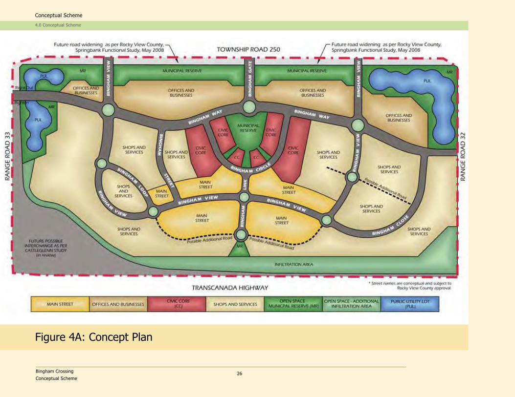
Previous sections of this conceptual Scheme have provided background
information and development rationale for the Bingham crossing project.
the project is comprised of three major components that, when integrated
together, will form a master planned and comprehensive development.
these components are commercial development, office/business and
open spaces; each will be discussed in more detail in this section and
are shown graphically in Figure 4A on the following page. this section
will also introduce policy directives which will be adopted with council’s
approval of the conceptual Scheme.
the project is comprised
of three major components
that, when integrated
together, will form a master
planned and comprehensive
development.
conceptual Scheme
4.0 conceptual Scheme
26Bingham crossing
conceptual Scheme
conceptual Scheme
4.0 conceptual Scheme
Figure 4A: concept Plan

27 Bingham crossing
conceptual Scheme
conceptual Scheme
4.1 commercial Development
4.1 commercial Development
Approximately two-thirds of the Bingham crossing project is intended
for commercial development (Figure 4A). this will be in the form of
stores, services, restaurants, hotels, entertainment facilities, offices, a
visitor centre, and leisure opportunities. At ultimate build-out, Bingham
crossing is anticipated to have ±146,136 m2 (±1,573,000 ft2) of the
aforementioned types of commercial services and generate over 2,000
jobs (full time and part time).
the vision for this project is a cohesive and comprehensive development
with strict architectural standards mandatory for buildings. Proposed
architectural guidelines will ensure consistency and scale of buildings
within the commercial area that aids in the overall visitor experience
and view from the neighbourhood. Although not finalized at this time,
preliminary site plans have been generated with careful attention to
building placement, spacing, type, form, footprint, and adjacent impact.
commercial buildings will be pedestrian scaled using elements such as
canopies, arcades, display windows, detailed entrances and projections,
peaked roofs, and articulated walls to encourage a street level presence.
while covering ±200 acres, the developers emphasize the importance
of human scale and pleasant pedestrian experiences while at Bingham
crossing. considering the highly visible location of Bingham crossing
from the transcanada Highway, hotels, accommodation and tourist
destinations may also be considered in the commercial areas.
commercial development will be developed as various retail formats and in specific locations. the formats will be a civic pedestrian core, a main street area, and shops and services. each will be well connected through the local roadway system, sidewalks and off-street pathways (for pedestrians and cyclists).
the commercial area will be screened from the transcanada Highway and not highly visible from the nearby residential areas. From the transcanada Highway, the adjacent open space will be landscaped with trees, shrubs and/or berms as possible. From the adjacent residential areas, the separation will be achieved by the addition of an expansive linear parkway with trees, pathways and ponds along the north and east property lines of the site.
Bingham crossing is envisioned to be a well-connected pedestrian
environment. connectivity between buildings and uses will be easy,
accomplished through block layouts, locations of key nodes, moderate
walking distances between businesses, and well designed landscaping
(such as tree-lined corridors) to encourage a safe and walkable public
environment.
the following policies apply to the commercial uses at Bingham crossing:
Policy 4.1.1: the Bingham crossing development shall provide
commercial uses in the area which could include uses
such as retail stores, services, restaurants, hotels,
entertainment, and leisure uses. opportunities for office/
employment uses to be developed within the commercial
area are to be encouraged where possible.
Policy 4.1.2: Architectural standards shall adhere to the “Bingham
crossing Architectural Design Guidelines - commercial”
established by the developer and shall be registered on
title to ensure a consistent, high quality development.

28Bingham crossing
conceptual Scheme
Policy 4.1.3: Based on the submitted Retail opportunity Study, the
Bingham crossing development’s commercial uses should
not exceed ±146,136 m2 (±1,573,000 ft2) at full build-out
in order to remain economically sustainable.
Policy 4.1.4: A re-evaluation of the maximum build-out size could occur
with a subsequent retail study.
Policy 4.1.5: commercial uses adjacent to Highway 1 (transcanada)
will be screened from the highway by a linear park and
pathways, and landscaped with trees, fencing, and/or
berms to ensure an effective visual barrier and transition
that is sensitive to existing viewsheds and landscape
character.
Policy 4.1.6: commercial uses will be located in three areas of the
community: civic core, main street, and Shops and
Services linked by a primary retail spine, as well as
pedestrian connections to form a comprehensively
designed commercial centre to the development. where
opportunity exists, office/employment uses should be
encouraged to locate in these three areas as well.
Policy 4.1.7: Pedestrian connectivity will be paramount to Bingham
crossing and will be accomplished through well defined
block layouts, key activity spaces, 5 to 15 minute walking
distances between businesses, and landscaping including
tree-lined corridors to create a safe and walkable public
environment.
Policy 4.1.8: A blend of large-scale retail (with maximum areas of
±15,794 m2 ( ±170,000 ft2 ) will be determined by future
land use applications), smaller independent shops and
mid-sized retailers will provide a range of high end goods
and services.
conceptual Scheme
4.2 office/Business District
Policy 4.1.9: commercial buildings will be pedestrian scaled using
elements such as canopies, arcades, display windows,
columns, detailed entrances, projections, peaked roofs,
and articulated walls to encourage street level presence.
Policy 4.1.10: natural light and pedestrian scaled lighting will be
integrated throughout the commercial area to ensure a
comfortable, positive experience.
4.2 office/Business District
the office/business development will be primarily located along the
primary east-west connection road, but office uses can be considered
within the shops and services and main street districts. the office/
business district is situated in a key central area of Bingham crossing,
numerous services and amenities will be available to employers and
employees to encourage them to locate here. A viable and successful
office park development is dependent upon local amenities and services
to support the needs of the employees, strengthen the local employment
base and to encourage other supportive businesses to locate nearby.
this district will feature a campus-like setting with buildings, pathways
and trails interwoven through an extensive open space system. Building
architecture will be distinctive and highly articulated. with retail and open
space in proximity, there will be ample opportunity for eating, shopping
and recreational pursuits ensuring Bingham crossing is an enjoyable
place to work.
Policy 4.2.1: office and business uses within the office/business district
will be located within a campus-like setting featuring
pedestrian connections and open spaces.
Policy 4.2.2: office uses may be integrated throughout the commercial and/or main street areas in accordance with the design principles for the district.
Policy 4.2.3: Building architecture will be of a high quality using distinctive elements (such as prominent entrances, architectural detailing and human scaled elements) to create a positive environment for employees.

29 Bingham crossing
conceptual Scheme
4.3 Pedestrian circulation
Pedestrian circulation is defined by a system of sidewalks, pathways, trails,
and roads. Based on historical experience, pedestrian circulation and
connectivity is enhanced when the route is obvious and reasonably direct,
and the walking time between destinations is limited to approximately
a 5 minute walk (400 metres). Figure 4B-open Space and Pedestrian
circulation Diagram identifies key activity spaces within Bingham crossing
with circles indicating a five minute walk. Pedestrian connections will be
designed to be well linked, safe, easy, and attractive to use. the plan
illustrates a network around activity spaces to tie the open spaces, the
office business campus and commercial areas together.
Policy 4.3.1: Prior to approval for subdivision or commercial and
business development, a pedestrian circulation plan
will be submitted that shows the following priorities are
implemented in the plan of subdivision or site plan:
• development is organized into units of a 400 metre
radius (5 minute walk) to facilitate walkable activity
spaces;
• layout of pedestrian features provides convenient, safe,
accessible, and attractive pedestrian routes for people
to park once and walk between businesses within
activity spaces; and
• open space features are integrated as detailed in
Section 4.3.2.
Policy 4.3.2: A pedestrian circulation network will utilize multi-use
regional pathways, traditional concrete sidewalks,
and multi-use rustic trails to create continuous, direct
pedestrian routes between the open spaces, office/
business campus and commercial area.
Policy 4.3.3: connect pedestrian-friendly activity centres to encourage
walking throughout the site and between the office/
business campus and commercial areas.
conceptual Scheme
4.3 Pedestrian circulation
Policy 4.3.4: Pedestrian routes must be accessible to the mobility
challenged citizens.
Policy 4.3.5: Plan for potential transit service by indicating approximate
future transit stops. ensure that street design will permit
these to function safely and allow for the provision of
transit amenities such as loading areas and bus shelters.

conceptual Scheme
4.3 Pedestrian circulation
Figure 4B: open Space and Pedestrian circulation Diagram
30Bingham crossing
conceptual Scheme

31 Bingham crossing
conceptual Scheme
conceptual Scheme
4.4 open Spaces
4.4 open Spaces
4.4.1 concept Summary
Bingham crossing proposes to allocate sufficient land for parks and
recreational needs. the open space network will be comprised of
privately owned (publicly accessible) and publicly owned areas, and will
take the form of two linear parks, one large central park, and a pocket
park. Municipal reserve will be dedicated as shown in Figure 4B-open
Space and Pedestrian circulation Diagram. the open space network
proposed within the project will support a sustainable, walkable and
visually appealing place to work, shop and play. it will also encourage
people to utilize the spaces as social gathering spots.
open spaces will be designed with various uses and users in mind. they
will range from active and programmed open spaces to passive, informal
and casual open spaces; all will be fully accessible to the public to promote
recreation, gathering and enjoyment. they will be well connected by
pathways, trails and sidewalks, and will converge into areas of softscape,
hardscape and public gathering places. Various forms of these open
spaces will be plazas, courtyards, linear parks and trails, active play areas,
and passive spaces.
conceptual north Linear Park - cross Section

32Bingham crossing
conceptual Scheme
open air concerts, skating, community events, and informal play/meeting
spaces. this space will serve as the central hub to the surrounding linear
park system, as well as for the extensive pedestrian network connecting
through and around the space.
the pocket park which lies to the south of the central open space provides
visual and physical connections to internal and external portions of the site.
Situated at the midpoint of the south linear park, it provides opportunities
for rest, for users of the rustic trail and provides a connection point along
the main civic axis. establishing a strong desire line through the site from
township Road 250, its incorporation creates a hierarchy of open space
and bolsters the prominence of the central civic open space.
A pedestrian circulation network (see Figure 4B-open Space and Pedestrian
circulation Diagram) will contain traditional concrete sidewalks, multi-use
regional pathways, and multi-use rustic trails. this network provides
for circulation within Bingham crossing and links key areas and open
spaces within the development. the paved sidewalks will be used by
pedestrians within the commercial areas. the multi-use regional pathway
will be located within the northern linear park and will provide for running,
cycling and in-line skating. the southerly linear park will contain a multi-
use rustic trail that will have a variety of uses (hiking, walking, running,
mountain biking, etc). trail and view nodes will be established throughout
the linear park system to provide opportunities for rest and for passive
interaction with the surrounding natural landscape. these nodes could
include a compliment of benches, informal gathering space or small built
structures such as a gazebo or similar.
in determining the design of the open space system, the existing site
conditions, topography and the proposed development were considered.
Figure 4B highlights the open space system and pedestrian circulation.
open spaces of various sizes, configurations and location will serve all
visitors of Bingham crossing.
within the open space network there are important contributors to the
overall quality of experience that Bingham crossing provides. this area
will account for 17% of the development not including small parks and
A natural environment philosophy will inspire the landscape and water
management design for the north perimeter linear park while maintaining
appropriate public uses. two naturalized wet ponds will be designed as
part of the stormwater facilities. A multi-use pathway will form part of a
regional linkage in the future. these facilities and the linear park system
as a whole will incorporate native vegetation (trees, shrubs, grasses,
and wildflowers) to ensure long term sustainability. the landscape will
feature prairie grasslands and native Aspen stands interconnected with
a pathway/trail system. Viewing decks, boardwalks and trail nodes will
allow opportunities for interaction and rest within the natural environment
in a serene setting. this park will be viewed along the length of township
Road 250 and will ensure a unique gateway to Bingham crossing. it
will provide a prairiescape entryway to the development and will buffer
the adjacent residents to the north and east from the development.
Residents’ views will be of an expansive green space that is available for
their passive leisure pursuits.
A second linear park located along the southerly boundary of Bingham
crossing, bordering the transcanada Highway will contain approximately
±8.0 ha (±20 acres) of park space. this green space will contain landscape
features, furnishings and thematic elements contributing positively to the
boundary interface. Signage, fencing, accent planting, and trail nodes will
complement an informal pathway corridor. this linear park system will
incorporate a natural plant palate with sweeping grassed berms accented
with clustered plantings of trees. it is envisioned that the pathways will
meander between berms revealing new perspectives in and out of the
site. natural swale areas with gravel beds will also be incorporated to
encourage infiltration and filtering of site surface water. An infiltration
bed located within the park will contain highly treated effluent water that
will be pumped from elsewhere on the site. these elements combined
will contribute to a positive aesthetic impression to travellers along the
transcanada Highway.
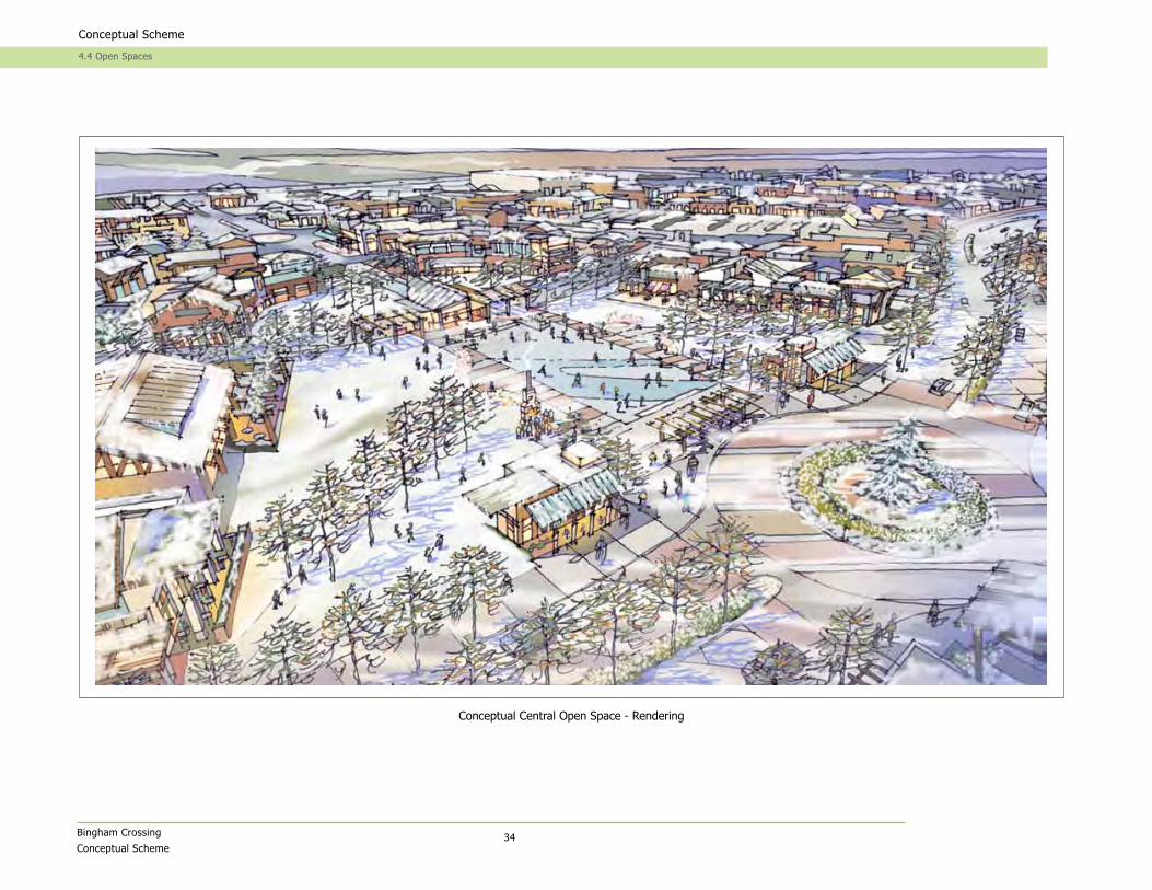
the central open space will function as the core of the development
and will be bordered by civic uses. this location will contribute to its
importance as the heart of the development. the concept is for a flexible
open space available for a venue of events such as farmer’s markets,
conceptual Scheme
4.4 open Spaces

33 Bingham crossing
conceptual Scheme
conceptual north Linear Park - Plan View
conceptual Scheme
4.4 open Spaces
conceptual South Linear Park and infiltration Bed - cross Section
34Bingham crossing
conceptual Scheme
conceptual central open Space - Rendering
conceptual Scheme
4.4 open Spaces

35 Bingham crossing
conceptual Scheme
conceptual Scheme
4.4 open Spaces
open spaces. open spaces are described in the following section – “key
Aspects of open Spaces” in the form of public spaces, semi-private/
communal spaces and streetscape.
4.4.2 key Aspects of the open Space System
open space can be defined as all land and water that offer some sense of
active or passive space for recreation. this can include parks, pathways,
plazas, paseos or areas that act as building buffers, quiet retreats,
children’s play area or social gathering spots. Main-street trees, plaza
trees, tree-lined boulevards, and key intersections are also integral to
the open space environment creating an ambience and highlighting key
features of Bingham crossing.
» Landscape:
• Plant mature trees to mitigate heat and glare from the sun
• use a rich and coordinated palette of landscape materials to provide
scale, texture, and colour
• encourage the use of drought tolerant / adapted species (not all
areas will be irrigated)
• use landscape to screen storage facilities, service areas, and
obscure parking
• Soften parking areas with landscaping
• trees and shrubs should provide year-round colour and interest
» outdoor Lighting:
• Provide pedestrian scaled light fixtures
• Space light fixtures at frequent intervals in active pedestrian zones
• incorporate lighting for use with public artwork and signage
• coordinate fixture design to contribute to open space identity
• Lighting at low heights to minimize light pollution (protect the
night-skies)
» Hardscape / Furniture:
• Provide ample outdoor furniture
• Group street furniture adjacent to points of interest (i.e., fountains,
artwork, landscaping, etc.)
• Locate street furniture to promote use; cluster items together to
facilitate gathering, socialization, etc.
• use paving to shape and embellish plazas
• water features that can be adapted for winter use (i.e. skating rinks
and ponds)
» Public Signage and Art:
• use art and signage to identify areas with a unique identity or
celebrate the entrance to a public place
• incorporate art into public infrastructure projects
• Present art to draw people through public spaces yet not impede
pedestrian flow (sculptures, murals, etc.)
• encourage works of civic art that reflect local history and culture
• Provide way finding (directional signage) and project identifiers
throughout
» Linear Parks:
• Active/passive leisure space
• wet ponds as landscape amenities
• educational opportunities
• use of native vegetation
• environmental and conservation
• Pathways
• Pedestrian corridor
• Visual entryway to development
• Signature lighting, planting and signage
» Plazas:
• Primary retail corridor
• Public green and pedestrian promenade
• Hardscape and softscape
• Multi-functional public space for festivals, farmer’s market, concerts,
etc.
» Paseos:
• narrow pedestrian passageway
• commercial activity

36Bingham crossing
conceptual Scheme
• Lighting, banners, trees, sculpture, etc., for accent
• Hardscaped
• Public or semi-private
» Pathways:
• Multi-use regional pathway
• Sidewalks
• Multi-use rustic trail
» Main-Street trees:
• traffic buffer between pedestrians and street
• Periodic planting of trees used to create pleasing rhythm
• trees provide micro-climate opportunities (i.e. protection from sun,
rain, wind, etc.)
» Plaza trees:• trees used to create an outdoor room effect• can be colourful or flowering trees
» tree-Lined Streets: • canopy trees create shade for pedestrians• creation of ambience for live/work residential streets
» key intersections:• Specialty paving• traffic calming• enhances district identity• Safety from oncoming traffic
» trail nodes:• Scattered throughout the network, placed at strategic intervals• envisioned to provide areas for rest and may incorporate such
elements as benches, small shade structures, gazebos, way-finding monuments, interpretive plaques, and programmable spaces, as well as garbage and recycling receptacles
• intended for both active and passive participation, the nodes will enhance the pedestrian experience along the path/trail network
• Provide opportunities for interaction within the natural environment in a serene setting
conceptual Scheme
4.4 open Spaces
conceptual central open Space - Plan View
conceptual South Pocket Park - Plan View

37 Bingham crossing
conceptual Scheme
conceptual Scheme
4.5 civic/Pedestrian core District
the following policies apply to open spaces within the Bingham crossing development:
Policy 4.4.1: the required municipal reserve will be provided and dedicated for parks, pathways and open spaces.
Policy 4.4.2: A Merchants’ Association is to be established to maintain open spaces.
Policy 4.4.3: until such time as the Merchant’s Association is established,
the developer shall be responsible for maintenance of all
open spaces.
Policy 4.4.4: Public open spaces such as parks, plazas, courtyards,
green roofs, and tree lined streets provide opportunities
for gathering, social interaction and play spaces as defined
in Section 4.4.2 key Aspects of the open Space System.
Policy 4.4.5: Streetscapes, referenced in 4.4.2 key Aspects of the open
Space System, are to be designed to create an ambience
and distinct identity in Bingham crossing.
Policy 4.4.6: the park, referenced in 4.4.2 key Aspects of the open
Space System - Linear Parks, along the south boundary
of Bingham crossing will function as an important entry
providing signature themed elements (signage, accent
planting, lighting, and fencing) to identify the development
while also serving as a regional pedestrian corridor and
infiltration bed.
Policy 4.4.7: the park referenced in 4.4.2 key Aspects of the open
Space System - Linear Parks, along the north boundary of
Bingham crossing is to be designed to create an extensive,
continuous green space that will serve as the gateway to
Bingham crossing. it will function as a multi-purpose
open space that serves a variety of needs and users by
providing opportunities for activities, gathering, passive
uses, and educational opportunities.
4.5 civic/Pedestrian core District
the civic core functions as the foundation of the community and will
contain main street type commercial uses, civic uses and parks. the
office/business park will be an additional land use to the civic core
district for longer term employment opportunities. the civic core will be
pedestrian oriented and include on-street parking, decorative sidewalks,
landscaping, trees, street theme elements (i.e. banners), and public art.
it will hold key events and allow for social and economic exchanges,
which will bring people together encouraging a sense of community.
community supportive services including non-profit groups should be
encouraged to locate in the civic core area. opportunities in the forms of
rent reduction, subsidies, services-in-kind (e.g. providing free or reduced
support services), and partnerships with local community groups should
be available to prospective organizations.
the following policies apply to the civic/pedestrian core district uses
within the Bingham crossing development:
Policy 4.5.1: the civic pedestrian core will contain a variety of uses that will include, but not be limited to:
• offices;• main street commercial uses (such as smaller
frontage, independent, etc.);• public open spaces and plazas; and• community services

38Bingham crossing
conceptual Scheme
the following policies apply to the main street uses within the Bingham
crossing development:
Policy 4.6.1: Main street uses will be located within a pedestrian
friendly, market environment that will allow opportunities
for interaction and socializing through the use of meeting
places, outdoor patios, landscaping, and other design
elements.
Policy 4.6.2: Buildings contained within the main street are to be
varied in height and appropriately articulated with façade
treatments on all sides using trellises, canopies, arcades,
and awnings to soften building edges materials such as
fieldstone, river rock, timber, copper, and slate.
Policy 4.6.3: Building frontages will be no greater than 30-40% of
the depth of the building to ensure a pedestrian scaled
environment.
4.7 Shops and Services District
Larger format retail uses are envisioned to be located as an outer layer to
the civic/pedestrian core and main street. these uses form an effective
buffer and transition from the heavy traffic volumes on the transcanada
Highway. Shops and services, as well as offices, could be interspersed
within the shopping area with landscaped parking lots, articulated
buildings, pedestrian connections, and low intensity lighting.
the following policies apply to the shops and services district within the
Bingham crossing development:
Policy 4.7.1: Large format retail uses will be located within a well
designed environment with pedestrian connections
between buildings.
Policy 4.5.2: the civic pedestrian core will serve as a central node within the development and will be designed to be pedestrian oriented using tree-lined corridors, public art, street furniture, and decorative elements and features to enhance its function.
Policy 4.5.3 the central open space will be a multi-purpose, easily adaptable area for a variety of uses such as: farmer’s markets, open air concerts, community events, and informal play and meeting spaces.
Policy 4.5.4: the developers of Bingham crossing should encourage
community-oriented or non-profit groups to locate within
the civic core area using incentives such as rent reduction,
subsidies, services-in-kind, and/or partnerships.
4.6 Main Street District
the main street commercial uses are the pedestrian focal point of
Bingham crossing. it is an area for shopping and socializing, and will
have buildings with varying heights and storefronts with the potential
for offices above the main floors. the buildings will be articulated on
all sides of the façades and will have street edges with small plazas to
enhance the pedestrian experience. Buildings will incorporate trellises,
canopies, arcades, and awnings to soften building edges. Building
materials will include organic and rustic materials. Shopping streets will
have restaurants, cafés and bistros to activate the walking corridors. the
combination of these elements will contribute to a unique atmosphere.
conceptual Scheme
4.6 Main Street District

39 Bingham crossing
conceptual Scheme
conceptual Scheme
4.8 Architectural Design Guidelines
Policy 4.7.2: Buildings will use pedestrian scaled elements such
as detailed entrances, projections, peaked roofs, and
articulated walls to encourage street level presence.
Policy 4.7.3: Landscaping, landscaped parking areas and low intensity
lighting will be integrated throughout this area to ensure a
comfortable, positive experience for pedestrians.
Policy 4.7.4: office and/or business campus uses can be considered
an appropriate use within the shops and services district
without amending this plan.
Policy 4.7.5: Accommodation and tourist destination uses may be
considered appropriate in the shops and services district
without amending this plan.
4.8 Architectural Design Guidelines
Bingham crossing is a retail shopping and business development set
in an urban pedestrian oriented environment. Development within
Bingham crossing will be consistent with the Design Guidelines in order to
ensure that it is sustainable, consistent, high quality, and human scaled.
emphasis is placed upon the building appearance and consistency.
Buildings, parking lots, social spaces, and open spaces shall be designed
to encourage ease of pedestrian movement and comfortable scale.
the Design Guidelines will be registered on the title of each lot.
Prospective tenants will be given a copy of the guidelines as part of the
lease agreement. Prior to submission of a Development Permit to Rocky
View county, the tenant will submit building plans to a tenant coordinator.
the tenant coordinator will review the plans to ensure that they comply
with the guidelines. if the plans comply, a letter will be provided to the
tenant from the tenant coordinator to be included with the Development
Permit application.
the Architectural Design Guidelines:
Policy 4.8.1: Shall be consistent with the design policies specified
throughout Section 4.0.
Policy 4.8.2: Should reinforce the design policies of Section 4.0 by
providing more detailed design guidance to existing policy.
Policy 4.8.3: Should provide detail to implement the following goals and
objectives:
• buildings that allow individuality while using quality
materials and finishes consistent with major regional
landscape features (Rocky Mountains meet the prairies);
• buildings will be pedestrian scaled using elements
such as canopies, arcades, display windows, detailed
entrances and projections, peaked roofs, and articulated
walls to encourage a street level presence;
• unique storefronts with ample transparency;
• simple and eye-catching themed signage to provide an
identity to the development;
• provide well established and comfortable areas for
outdoor dining with protection from the elements;
• create three activity centres, each with its own individual
character attributable to a mixture of uses, scales, open
spaces, and movement patterns;
• incorporate various open spaces such as plazas, green
spaces and outdoor rooms throughout the development;
• ensure visual and physical pedestrian connectivity
between sidewalks, pathways and open spaces;
• a Dark Sky Policy that requires lights to shine down and
have little or no light escaping upward; and
• building orientations and main entrances are
encouraged to focus on the street frontages.

40Bingham crossing
conceptual Scheme
conceptual Scheme
4.8 Architectural Design Guidelines
conceptual View from the northwest

41 Bingham crossing
conceptual Scheme
conceptual Scheme
4.9 interface Approach
Policy 4.8.4: Should implement the following sustainability goals:
• commercial and office buildings should incorporate
LeeD equivalent standards or better during design and
development;
• the location of building sites in Bingham crossing will be
deliberately thought out to address natural light, wind,
shadows, and connectivity; and
• water conservation measures such as water efficient
landscaping, low flush toilets and water use reduction.
4.9 interface Approach
Bingham crossing will be a good fit with the existing and future
communities in the region. Located along the transcanada Highway, it
is a location well-suited to retail development. Planning of the site has
considered the transition of uses and development density outwards to
the north boundary to respect current residents.
Access points are located in order to draw traffic to the collector road
network and not to encourage short-cutting or sight-seeing in the
development.
Phasing for development of Bingham crossing will start at the west
boundary and move eastward as market conditions and demand permit.
Following the eastward progression, it is anticipated that the final phases
of development will be the easterly portion of the site.
Adjacent uses to the east of the plan area contain country residential
development. these uses will be minimally impacted from an interface
perspective as a continuous linear parkway will be located along the north
boundary appropriately screening the adjacent development.
the following policies apply to the interface approach uses within the
Bingham crossing development:
Policy 4.9.1: An edge condition containing a linear greenbelt and
pathways, high quality building design materials,
landscaping, fencing, or berms along the transcanada
Highway will contribute to the entranceway to the city of
calgary and Rocky View county with respect to existing
view sheds and landscape corridors. As a gateway to
the Rockies, Bingham crossing will serve as an entryway
celebrating the surrounding environment of prairies
meeting the mountains.
Policy 4.9.2: An office and business park in a campus-like setting
combined with municipal reserve along the north boundary
of Bingham crossing will provide an effective buffer and
transition for the lands to the north.
Policy 4.9.3: Buildings along the easterly edge of Bingham crossing
will have enhanced architectural detail on each façade of
the building, fully screened garbage and loading areas,
low intensity, downward directed lighting, lower building
heights, and heavily landscaped side and rear yards to
effectively screen or transition uses to the east.conceptual civic Plaza - Rendering

5.0 Servicing and utilities

43 Bingham crossing
conceptual Scheme
Bingham crossing will be a fully serviced development and will include
a piped water supply, a fully charged hydrant system, sanitary sewer
servicing, and stormwater management facilities. A master water and
sanitary servicing plan will be prepared prior to initial subdivision approval,
and updates will be provided for each subsequent phase of development.
Phase 1 of the project will connect to a piped water supply provider and
will incorporate the collection and reuse of stormwater for irrigation
purposes within the site. the design, construction and maintenance of
utilities will be the sole responsibility and cost of the developer, with no
costs borne by Rocky View county.
this approach to servicing will further enhance the economic development
goals of Rocky View county because it can also benefit other current
and future developments in the region through roadway upgrades and
improvements, potential infrastructure availability (such as off-site water
lines, stormwater), and local population base.
5.1 Domestic water Supply
At full build-out of the Bingham crossing project, there may be a demand
of up to 215 acre-feet (265,000 cubic metres) of domestic water annually.
this water supply will be provided from the following sources:
• Phase 1 water demands of 47 acre-feet (58,000 cubic metres) will be
supplied by calalta waterworks Ltd. which operates a water supply
and treatment facility, located across the transcanada Highway, at the
calaway Park site. this volume of water is under contract between the
developer and calalta, and can be delivered to the Bingham site once a
treatment plant and storage reservoir are completed and a supply main
extended to the project. A transfer of license amendment has been
issued by Alberta environment for the 47 acre-feet.
• Bingham crossing Properties inc. is in the process of acquiring additional
water license transfers for their development. they currently have a
Memorandum of understanding with elbow Valley water corporation
for the transfer of 20 acre-feet to the site.
• Bordeaux Developments corporation has proposed to provide
additional treated water as required to the Bingham project site from
Servicing and utilities
5.1 Domestic water Supply
A comprehensive approach
to servicing furthers Rocky
View county’s economic
development goals
because it can also benefit
other current and future
developments in the region.

44Bingham crossing
conceptual Scheme
Servicing and utilities
5.1 Domestic water Supply
the water system that is being developed as part of the Harmony
project. Bordeaux would provide this treated water from a portion of
the preliminary certificate of water supply that Bordeaux has from the
Bow River. this additional water supply will satisfy the remainder of
the Bingham project, and complete the water demands for the project.
All of the above water supplies will feed a below ground treated water and
fire protection reservoir within the Bingham site, as shown on Figure 5A.
A distribution pumphouse will be located adjacent to the reservoir that will
supply water to a looped internal water system that will be developed as
part of the Bingham project.
Bingham crossing recognizes the value of water as a limited natural
resource and will implement low water consumption principles into the
design of landscaping. these will include low maintenance or xeriscape
landscaping, mandatory water meters, low flow water fixtures (for
example, toilets, sinks, showers, appliances), and rainwater collection
areas for irrigating open space.
All potable water, fire protection water and delivery components will be
paid for by the developer, and Rocky View county will not be requested to
finance or incur debt for these components.
the following policies will be applied to water services for Bingham crossing:
Policy 5.1.1: water services for all phases of Bingham crossing will be from an approved piped water supply system.
Policy 5.1.2: Fire suppression infrastructure shall be provided through
a charged hydrant system that is consistent with national
Fire Protection Association standards.
Policy 5.1.3: water conservation measures will be implemented through architectural controls and include, but are not limited to, low maintenance or xeriscape landscaping, mandatory water meters, low flow water fixtures, and rainwater collection areas.

Figure 5A: conceptual Location for Major water and Sanitary Facilities
Servicing and utilities
5.1 Domestic water Supply
45 Bingham crossing
conceptual Scheme

46Bingham crossing
conceptual Scheme
Servicing and utilities
5.2 wastewater collection, treatment and Disposal
Policy 5.1.4: A water servicing analysis will be submitted to Rocky View county at the time of subdivision approval.
Policy 5.1.5: An agreement relating to the Bingham crossing utility including system design criteria, overall water system ownership, ownership of lands accommodating utility components, system financing, and system operations will be executed between Bingham crossing Properties inc. and Rocky View county prior to the initial subdivision approval.
5.2 wastewater collection, treatment and Disposal
As mentioned in the previous section, water service will be provided by the
previously mentioned three sources. there will be no sanitary capacity
available from Harmony developments for the Bingham crossing project.
therefore, this conceptual Scheme is proposing a phased approach for
the sanitary treatment. Details of the proposed sanitary system are
described below and it is noted that all costs for the treatment works and
ground disposal system will be designed, constructed and financed by the
developer, with no costs or debt incurred by Rocky View county.
Sanitary servicing for the Phase 1 lands will be handled by a packaged
wastewater treatment plant. this wastewater treatment plant will be
located in Phase 1 with discharge to a disposal field located along the
south boundary of the site. the wastewater treatment plant will be sized
for the ultimate flows from the previously mentioned water licenses, with
expansions of the facility developed as the project phases proceed. the
treatment plant will have the appearance of a small commercial building
and will be designed to complement adjacent buildings. wastewater
will be treated to a quality that is in excess of that required to meet
existing provincial standards for ground disposal of effluent. the facility
will be an advanced wastewater treatment plant that will incorporate flow
equalization, biological treatment, membrane filtration, and ultraviolet
disinfection. effluent from the development will achieve the standards
dictated by Alberta environment in table 3.1 or 3.2 of the Standards and
Guidelines as determined by the Provincial Regulator.
the treated effluent will be released in subsurface disposal fields that are
located below frost level, whereby the effluent will be further filtered by the
native soils and existing soil bacteria. An infiltration area will be located in
the south linear park along the transcanada Highway. this green space
will be landscaped with signature trees, fencing and pathways providing a
prominent entry to the development. equalization storage will reduce and
moderate peak inflows and will optimize the size of the treatment works,
providing a more consistent flow rate and improved performance. the
treatment and disposal facilities will be componetized, thereby allowing
parallel expansions with future phases.
A preliminary hydrogeological report will be prepared by a qualified
hydrogeologist to understand the movement of the treated effluent
into underground aquifers and to ensure there is no negative impact
to neighbouring wells prior to conceptual Scheme approval. the
groundwater return must be approved by Alberta environment (AenV)
under the water Act in Alberta. the final hydrogeological report will be
prepared prior to subdivision approval of Phase 1.
the following policies will be applied to sanitary services for Bingham
crossing:
Policy 5.2.1: effluent for Phases 1, 2 and 3 lands will be accommodated
through an advanced wastewater treatment facility with
ground disposal.
Policy 5.2.2: effluent treatment and disposal works will be phased
and sized to accommodate the approved land use
redesignations. Sizing will be designed to accommodate
demands for each phase with subdivision or development
applications.
Policy 5.2.3: A sanitary servicing analysis will be provided to Rocky
View county prior to subdivision approval at each phase of
subdivision.

47 Bingham crossing
conceptual Scheme
Servicing and utilities
5.3 Stormwater Management
Policy 5.2.4: A final hydrogeological report will be prepared prior to
subdivision approval of Phase 1 of Bingham crossing.
5.3 Stormwater Management
An overall stormwater management plan has been undertaken to
accommodate and integrate the stormwater runoff in the Bingham
crossing project. the stormwater ponds and the entire underground
piping network associated with on-site stormwater will be designed,
constructed and financed by the developer. Rocky View county will not
be requested to finance or incur debt for these components.
the stormwater Master Drainage Plan considers on-site flow conveyance
and storage facilities that allow for the runoff leaving the site to be
consistent with the pre-development runoff rates.
the overall stormwater management system for the proposed
development consists of two basic components:
1) existing off-site drainage courses to convey site runoff to the downstream receiving water bodies.
2) on-site storage facilities to manage the quality of and rate at which runoff leaves the site.
Runoff from the site and adjacent public roads currently drains to
two different receiving water bodies via separate drainage courses.
Approximately ±54 ha (±133 acres) of land currently drains toward the
southwest corner of the site and enters the existing ditch/gully system
that ultimately reaches the elbow River. the remaining ±78 ha (±193
acres) of land currently drains toward the northeast corner of the site
and enters the ditch/gully system that ultimately reaches the Bow River.
the post-development drainage areas may vary slightly from the pre-
development areas and appropriate accommodation for runoff allowances
will be made.
each of the existing drainage courses noted above will be reviewed to
ensure the following:
• there are no existing downstream obstructions or erosion issues.
• Discharge from the Bingham crossing project will not directly cause
erosion to the existing drainage course or create flooding concerns.
the stormwater management system proposed for the Bingham crossing
project is to be designed using a minor (piped) and major (overland)
system. curb and gutter, and catchbasins along roadways and in parking
areas will convey runoff to one of two stormwater storage facilities (wet
ponds). A portion of the stormwater will be conveyed to green spaces for
irrigation purposes. the storage facilities will be located in the northeast
and northwest corners of the project area. each facility will be designed
to accommodate the 100 year storage and water quality requirements
established by Alberta environment. Additionally, the storage facilities
will be designed such that the post-development discharge rate from
them will be consistent with the pre-development rate. the Drainage
Strategies for Springbank, westhoff engineering Resources Ltd., january
2004 report established a pre-development discharge rate for the area
of 1.714 L/s/ha. this discharge rate applies to both the elbow River and
the Bow River.
the following policies will apply to the development of the stormwater
management system for the Bingham crossing project.
Policy 5.3.1: the project will have an urban minor/major stormwater
system that connects either storage facility (wet ponds
located on the east and west sides of the site). each pond
will be located in a PuL.
Policy 5.3.2: each wet pond will be designed to ensure that the
discharge rate from the pond will be required to meet
Subdivision Drainage Strategies (westhoff engineering,
2004) and Alberta environment water quality guidelines.
Policy 5.3.3: with the submission of the first and each subsequent
subdivision plan for the project, a Stormwater Management
Plan is to be submitted for review and approval by Rocky
View county.

48Bingham crossing
conceptual Scheme
Servicing and utilities
5.4 Shallow utilities
Policy 5.3.4: Development of individual commercial and institutional lots
will require a Site Drainage Plan and possibly an overland
Drainage Plan to be submitted for review and approval by
Rocky View county.
5.4 Shallow utilities
Bingham crossing will be fully serviced at each phase with shallow
utilities being natural gas, electricity, telephone, and fibre optic services.
connections to each utility will be provided by extensions from existing
services in the area.
the following policies will apply regarding the provision of shallow utilities:
Policy 5.4.1: each phase of the development will be fully serviced
with electrical, natural gas, telephone, and fibre optic
connections.
Policy 5.4.2: Locations for easements for shallow utility extensions will
be determined at the subdivision stage.
Policy 5.4.3: electrical power will be transmitted by underground power
cables.
5.5 Solid waste Management
Respecting the environment and minimizing waste will be encouraged at
Bingham crossing. examples will include the introduction of a recycling
program, composting opportunities and utilization of mulch.
During construction of the project, waste minimization will be encouraged
through building industry environmental practices.
the following policy will apply to waste management practices at Bingham
crossing:

49 Bingham crossing
conceptual Scheme
Servicing and utilities
5.6 emergency and Postal Services
Policy 5.5.1 : with each application for subdivision, a waste management
strategy is to be submitted which will address recycling,
composting and utilization of mulch.
5.6 emergency and Postal Services
Protective services for Bingham crossing will be provided through Rocky
View county and its urban neighbours. Policing services are provided
by county Peace officers who are responsible for enforcing municipal
bylaws and provincial statutes. in addition to county Protective Services,
there are three RcMP detachments that service the county. the closest
detachment to Bingham crossing is located in the town of cochrane.
Private security and closed circuit cameras will further enhance on-site
security for Bingham crossing.
Ambulance service within the county is the responsibility of Alberta Health
Services. Fire service to Bingham crossing will be provided by Rocky View
Fire Services at Station 71 located at the Springbank Airport and Station
74 in elbow Valley. Mail will be delivered by canada Post via a commercial
and office system.

6.0 transportation

51 Bingham crossing
conceptual Scheme
the Bingham crossing project is located directly on the transcanada
Highway and has tremendous exposure to this corridor. A detailed traffic
impact Assessment (tiA) has been prepared in support of this conceptual
Scheme and submitted to Rocky View county under separate cover.
Recommendations from the tiA have provided direction for internal road
sizings and the regional road network improvements.
6.1 Regional and Local Road network
Bingham crossing is well served by an established network of regional
roads as shown graphically on Figure 6A.
the transcanada Highway is adjacent to the south boundary of the plan
area. it is a four lane divided highway with limited access points. Range
Road 33 runs along the west side of the site and is under the jurisdiction
of Rocky View county. it is currently developed as a paved two lane
rural road. the site is bound on its north boundary by township Road
250 which is also currently a paved two lane rural road. Lastly, the site is
bound on the east side by Range Road 32 which is an undeveloped road
allowance.
Bingham crossing is well
served by an established
network of regional roads.
transportation
6.1 Regional and Local Road network

52Bingham crossing
conceptual Scheme
6.2 internal Road network
Bingham crossing will have a road network designed to provide safe,
efficient and quick access within the development. Because this is a
large scale comprehensive development, all internal roads could be
privately owned and maintained by the landowner(s) under a bareland
condominium arrangement. Alternatively, the internal roads could be
public roads owned by Rocky View county. Road right-of-way ownership
is to be decided at the subdivision stage. in either case, all roads would
be fully accessed to the public at all times. the internal road network is
designed to contain commercial traffic, to control possible congestion and
minimize shortcutting.
there are several accesses proposed to the site from the adjacent Rocky
View county roadways. note that Bingham crossing is not considering
any direct access from the transcanada Highway.
the right-in/right-out access on Range Road 33 which will be spaced
approximately 160 metres from the north right-of-way boundary on
township Road 250 at the intersection with Range Road 33. Discussions
have occurred with At and Rocky View county regarding this access and
will continue in the future.
Along township Road 250, there are three entrances proposed to access
the future phases of commercial and business development. All three will
be all-turns accesses. Lastly, there is one east access proposed along
Range Road 32. these access and internal road patterns are illustrated
in Figure 6A.
Rocky View county and the area developers jointly commissioned a study
of the regional road network in the Springbank area. the Regional Road
network study established the long-term road network needed to support
development in the area. Direction for growth areas were provided
by Rocky View county planning staff using approved or proposed
developments to calculate growth probabilities.
the study provided Rocky View county and the development community
guidance on major and collector roadway locations, needs, and right-of-
way requirements. it established anticipated intersection configurations,
intersection control, and estimated construction costs. Rocky View
county will use this information to guide development as it proceeds, as
well as to develop cost sharing policies and cost monitoring procedures
so the cost for the necessary infrastructure is equitably shared amongst
area developers.
castleGlenn consulting recently completed a functional study of the
Highway 1/Range Road 33 interchange as commissioned by Alberta
transportation. the functional study has been completed and recently
presented to Rocky View county’s infrastructure and operations
committee who accepted the findings and recommendations of the
study. A staged improvement plan has been recommended for the
interchange that will reflect ongoing needs and growth in the region. the
study has considered access options to Bingham crossing relating to the
staged improvements to the Highway 1/Range Road 33 interchange. A
recommendation for allowance of a right-in/right-out access on Range
Road 33 was presented as part of the study conclusions.
the Bingham crossing development will require upgrades to the regional
and local road network. these improvements are detailed in Section 6.3.
transportation
6.2 internal Road network

transportation
6.2 internal Road network
Figure 6A: Primary Road network circulation Diagram
53 Bingham crossing
conceptual Scheme

54Bingham crossing
conceptual Scheme
transportation
6.3 improvements and Phasing
the roadway classifications of the access roads are as follows:
• west Development Access (on Range Road 33) – Primary collector
Road (10,000 vehicles per day)
• First north Development Access (on township Road 250) – Major Road
(12,500 vehicles per day)
• Second north Development Access (on township Road 250) – Major
Road (15,000 vehicles per day)
• third north Development Access (on township Road 250) – Primary
collector Road (7,000 vehicles per day)
• east Development Access (on Range Road 32) – collector Road (4,500
vehicles per day)
within the development there will be two main spine roads: an east-to-
west road through the central area of the site and a gateway entrance
running north-south also through the central area of the site. Smaller
commercial access roads will run through the site from these main spine
roads to individual buildings and parking lots. this internal network
is shown on the conceptual Scheme, but will be finalized with future
development permit applications.
the following policies shall apply to the local road network for Bingham
crossing:
Policy 6.2.1: there shall be no direct access to the transcanada
Highway.
Policy 6.2.2: Accesses to the Bingham crossing project shall be
generally as shown on the conceptual Scheme.
Policy 6.2.3: A roadside development permit shall be applied for before
access is granted for new approaches.
Policy 6.2.4: the development shall implement all recommendations
related to internal road improvements identified in the tiA
or as otherwise required by Rocky View county.
Policy 6.2.5: All internal roads are to be constructed and maintained in
accordance with Rocky View county’s Servicing Standards,
as amended, at the developer’s expense should they
ultimately be dedicated as public road rights-of-way to the
county. Alternatively, should the road remain privately
owned by the Merchant’s Association as a bareland
condominium, ownership and maintenance will be the
responsibility of the Merchant’s Association after the
maintenance period by the developer.
Policy 6.2.6: All roads within Bingham crossing shall be fully accessible
to the public regardless if they are a public right-of-way or
a private road allowance.
6.3 improvements and Phasing
Details of the transportation network improvements are defined in the
tiA. the summary of improvements and implementation year are shown
in Figure 6B and are described below.
For Phase 1 of Bingham crossing, the following improvements are
recommended by 2012:
• traffic signals at the following intersections:
- Range Road 33/Highway 1 interchange (south intersection)
- Range Road 33/township Road 250
- township Road 250/north Development Access (first access east
of Range Road 33)
• construction of the ultimate westbound to northbound interchange
ramp on the northeast corner of the Range Road 33 and Highway
1 interchange which allows only for the westbound to northbound
movement as the existing westbound to southbound loop ramp on
the northwest corner is maintained for the right turn movement only.
this is subject to Alberta transportation approvals.
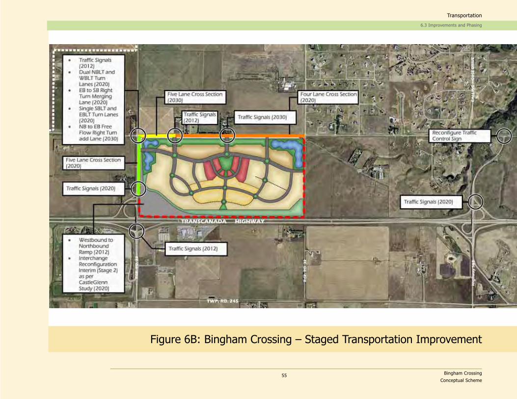
transportation
55
6.3 improvements and Phasing
Bingham crossing
conceptual Scheme
Figure 6B: Bingham crossing – Staged transportation improvement

56Bingham crossing
conceptual Scheme
Further road network improvements are recommended as Bingham
crossing builds out. the improvements required by the 2020 (10 year)
and 2030 (20 year) horizons are indicated as follows:
2020
• Reconfiguration of the Range Road 33/Highway 1 interchange
to Stage ii as per castleGlenn’s draft Highway 1/Range Road 33
Functional Study for Alberta transportation.
• traffic signals at the following intersections (beyond those identified
for Phase 1):
- Range Road 33/Highway 1 interchange (north intersection)
- Highway 563/Highway 1 interchange (north intersection)
• Five lane divided roadway (three northbound and two southbound)
on Range Road 33 from the end of the westbound to northbound
Range Road 33/Highway 1 interchange ramp to township Road 250.
• Four lane divided roadway on township Road 250 from Range Road
33 to just east of Range Road 32.
• At the intersection of Range Road 33 and township Road 250:
- northbound to westbound, and westbound to southbound dual
left turn lanes
- Southbound to eastbound, and eastbound to northbound single
left turn lanes
- exclusive eastbound to southbound right turn merging lane
• Reconfiguration of signage at township Road 250/Range Road 31 to
have northbound to westbound, and eastbound to southbound as
free flow main movement.
2030• Five lane divided roadway (three eastbound and two westbound)
on township Road 250 from Range Road 33 to the first north Development Access east of Range Road 33. the additional eastbound lane on township Road 250 is an auxiliary lane for northbound to eastbound right turn traffic coming from Range Road 33 and drops at the first north Development Access.
• Additional traffic signals at township Road 250/north development access (second access east of Range Road 33).
6.3 improvements and Phasing
transportation
conceptual cross sections for the transcanada Highway, Range Road 33
and township Road 250 are shown in Figures 6c, 6D and 6e, respectively.
the following policies shall apply to the Bingham crossing development
regarding improvements and phasing:
Policy 6.3.1: transportation network improvements shall be as
recommended in the tiA or as otherwise required by
Rocky View county.
Policy 6.3.2: timing and cost obligations for improvements shall be
determined at the subdivision stage for each phase of
development.
Policy 6.3.3: Recommendations for traffic network improvements in
the tiA may be revisited if development scenarios in the
region are significantly modified from the models utilized
in the tiA.

transportation
57
6.3 improvements and Phasing
Figure 6c: Section at transcanada Highway
Bingham crossing
conceptual Scheme
n.t.S* concept Drawing

transportation
58
6.3 improvements and Phasing
Figure 6D: Section at Range Road 33
Bingham crossing
conceptual Scheme
//
* concept Drawingn.t.S

59
6.3 improvements and Phasing
transportation
6.3 improvements and Phasing
Bingham crossing
conceptual Scheme
Figure 6e: Section at township Road 250
n.t.S* concept Drawing

7.0 Policy Review

61 Bingham crossing
conceptual Scheme
7.1 introduction
the Bingham crossing conceptual Scheme falls within several municipal
policy areas including the Municipal Development Plan, the MD of Rocky
View/city of calgary intermunicipal Development Plan, the MD of
Rocky View economic Development Strategy, and the north Springbank
Area Structure Plan. these policies provide guidance for planning and
development in the subject area. this section explores how the Bingham
crossing conceptual Scheme meets the goals and intent of these policy
documents.
7.2 Rocky View 2060 - Growth Management Strategy
on june 18, 2009, the final Growth Management Strategy was presented
to Rocky View council. it has been developed to provide a land use vision
for Rocky View county that uses the principles of sustainability, smart
growth and triple bottom line decision making. it takes into consideration
current planning that is underway, such as the calgary Regional
Partnership and the Provincial Land use Framework. the purpose of
the document is to establish a long term vision for Rocky View while
respecting anticipated growth over the next 50 years.
the county endorses policy that uses Smart Growth principles to guide
development. Smart Growth endeavours to improve our quality of
life, preserve the environment and be economically responsible. the
principles encourage growth that is fiscally, environmentally and socially
sustainable, and acknowledges the linkages between development and
quality of life. Bingham crossing is located in proximity to country
residential development, as well as the planned concentrated complete
community of Harmony. the location of local residential communities
will support the commercial and employment nature of the development.
Bingham crossing will contain a mix of uses including commercial, office/
business and open spaces integrated with pathways, trails and potential
transit stops that will provide employment opportunities, transportation
choices and pedestrian linkages to surrounding areas. the development
will use green building strategies to assist in protection of the environment.
these policies provide
guidance for planning and
development in the subject
area. this section explores
how the Bingham crossing
conceptual Scheme meets the
goals and intent of these policy
documents.
Policy Review
7.1 introduction
62Bingham crossing
conceptual Scheme
the combination of providing a well-planned commercial development
and office campus will contribute a strong property tax base to Rocky
View county.
the compilation of the values of residents and Smart Growth principles
with municipal background reports and best practice research led to
the development of Rocky View county’s Growth Management Strategy
themes. Specific themes regarding existing infrastructure and economic
viability relate to Bingham crossing. Bingham crossing is located at the
intersection of the transcanada Highway and Range Road 33. the road
infrastructure, consisting of an established network of regional roads,
currently exists to support the development. other infrastructure such
as water, power, natural gas, electricity, etc., is readily available through
extensions from existing services in the area. the development will
provide retail and office employment opportunities that will assist in
strengthening the economic sustainability of the county.
these themes relate to the triple bottom line approach that will be
used to analyze future developments. the triple Bottom Line Approach
uses social, environmental and economic indicators as measures of
sustainability. the following explores the measures as they correlate to
the development:
SociAL
• Bingham crossing will provide retail and office employment
opportunities, increasing job prospects in the area.
• Bingham crossing will be attractively designed containing a mix of uses
that includes retail, office/business, extensive open spaces and wet
ponds integrated with pathways and trails. walkable street design
in the core of the development combined with civic parks and open
spaces will provide places for people to bump into one another and
contribute to a sense of community.
• Local recreational opportunities such as walking and cycling trails, wet
ponds, skating rinks, gathering spaces, and plazas will be available to
residents in the area.
enViRonMentAL• Bingham crossing will respect the environment through the application
of such things as LeeD design, water usage restrictions and energy management. wastewater will be handled by an on-site packaged wastewater treatment plant that will treat effluent to a quality that is in excess of that required to meet existing provincial standards for ground disposal of effluent.
econoMic • A mix of uses including retail and office/business will contribute
positively to Rocky View county’s tax base as the development proposes an increase in commercial and office business development for the area.
the Growth Management Strategy Map (Figure 7A) identifies four Major Business corridors. the location of Bingham crossing is consistent with the location of the Major Business corridor along the transcanada Highway (Highway 1) west of the city of calgary.
Bingham crossing is consistent with the vision for a Major Business corridor. it is designed as a concentrated node adjacent to the interchange at the intersection of the transcanada Highway and Range Road 33. the location has prominent visibility from Highway 1, which is a busy corridor to the Rockies and beyond. Signature theming will celebrate and enhance this location, taking advantage of the visibility from the highway.
Development will integrate into the landscape by using various elements
such as prairie like parks, extensive green spaces, native trees and
vegetation, wet ponds, and articulated buildings that use organic and
rustic materials present in the landscape. extensive linear parks along
the north and south boundaries of the development provide recreational
opportunities and sensitive transition to adjacent existing residential
dwellings and the transcanada Highway.
Adjacent uses and developments such as the edge School, commercial court, Harmony, and the Springbank Airport offer a market base for the area and the prominent location along the transcanada Highway provides access to regional and provincial markets. Bingham crossing will play a role in diversifying the tax base within Rocky View county providing retail and employment opportunities for residents in the area.
Policy Review
7.2 Rocky View 2060 - Growth Management Strategy

Policy Review
63
7.2 Rocky View 2060 - Growth Management Strategy
Figure 7A: Growth Management Strategy Map
Bingham crossing
conceptual Scheme
Source: Rocky View 2060 Growth Management Strategy

64Bingham crossing
conceptual Scheme
appropriately located along the transcanada Highway which is a heavily
used and busy corridor.
one of the nSASP Plan objectives states that a goal is “to establish a
framework of land use, subdivision and development policies to guide
and manage development in the vicinity of the Springbank Airport,
which ensures restrictions around the airport are minimized and provides
alternative land uses for restricted areas” (Section 3.5). the Bingham
crossing conceptual Scheme endeavours to provide an alternative to
residential land use in an area already impacted by both the Springbank
Airport and the transcanada Highway. this alternative may also be more
in keeping with the nSASP Plan objective that states a goal is “to establish
policies for lands adjacent to Highway #1 which respect and preserve the
functional integrity of this transportation corridor” (Section 3.7).
the proposed Bingham crossing conceptual Scheme is deemed to be
inconsistent with policy 5.1.4 of the nSASP which states that “commercial
based business development shall be restricted to these areas already
designated south of Highway 1, those lands impacted by airport operations
as described in Section 5.1.3 and on the airport itself”. therefore, a
site specific amendment process, being undertaken concurrent with the
conceptual Scheme, is in conformance with Section 5.4.6 of the nSASP
and council’s direction of june 27, 2006.
nSASP policy also indicates that the Plan was intended to be reviewed
regularly “….in order to verify that the Plan objectives and policies are
current, effective and consistent with other statutory plans…”, but no
review has occurred in the intervening eight years.
7.3 north Springbank Area Structure Plan
the north Springbank Area Structure Plan (nSASP) is a statutory plan
regulated by the Municipal Government Act. it accompanies the broad
based objectives of the Municipal Development Plan and is a more detailed
framework for the pattern of development in an area. it sets the strategy
for redesignation, subdivision and development applications, and has
provision to undertake an amendment to the plan when it is technically
deemed to be non-conforming. Section 1.4 of the nSASP indicates that
as a guideline for development, the nSASP should be revisited when
land use planning issues emerge as time progresses. Further to this, the
nSASP cannot contemplate all future impacts and, therefore, allows for
the flexibility of requesting a further review of policies that may require
further study.
the proposed Bingham conceptual Scheme is consistent with the nSASP’s
general objectives in terms of ensuring standards and development
guidelines for commercial based business development and preserving
the functional integrity of the transcanada corridor.
the future land use concept in the nSASP for Bingham crossing
contemplates this land as potential residential. the conceptual Scheme
proposes commercial uses in a comprehensively designed development
which will attract people who work, shop and recreate close to home
thereby contributing to a more sustainable way of life.
7.3.1 Business Land use
the nSASP supports a general idea that stand-alone commercial
developments may provide goods and services to the local community, the
travelling public or a recreational market. the conceptual Scheme aligns
with this idea by suggesting a development that will enhance the lifestyle
of area residents and support the increased growth of the Springbank
Airport. the northerly portion of the plan area, consisting of an office/
business campus and linear parkway, will buffer existing residential to the
northeast. it will also aid in transitioning the site to the commercial uses,
Policy Review
7.3 north Springbank Area Structure Plan

65 Bingham crossing
conceptual Scheme
7.4 the Municipal Development Plan
the broadest statutory policy document relevant to this proposal is the
Municipal Development Plan (MDP).
Relevant MDP goals include:
• “ to accommodate growth and change in the Municipality with sound
land use planning; and
• encourage and facilitate appropriately-located business development,
which contributes to the economy of the Municipality.”
7.3.2 Highway 1 interface
Bingham crossing is located within the Highway 1 interface. the lands
within this area are subject to specific provisions in order to ensure the
safety and function of the highway are not impeded and that future
land uses do not impair its function. Bingham crossing will respect
these policies. in conjunction with Rocky View county and other area
developers, a study of the regional road network in the Springbank area
has been commissioned. Further to this, the study will also consider
ultimate access/egress to the site. A green perimeter will be located
adjacent to the transcanada Highway. this will contain a linear greenbelt
consisting of pathways, landscaping, fencing, and berming along the
length of the site. this visual amenity will provide a safety zone between
the site and the transcanada Highway.
Policy Review
7.4 the Municipal Development Plan

66Bingham crossing
conceptual Scheme
7.4.2 open Space and Recreation
the open space and recreation goal stated within the MDP is “to support
the retention and enhancement of open spaces and recreational facilities
in the Municipality”.
Further policies include:
• “the Municipality will encourage the amalgamation and linking of open
spaces where appropriate; and
• through the development of a regional recreational trail system, the
Municipality encourages trails as passive recreational opportunities
within existing and developing communities.”
these goals have been instilled in Bingham crossing. Significant open
spaces have been designed to provide connectivity as part of an integrated
open space system throughout the county to provide both active and
passive recreation spaces.
7.4.1 Business Development
Regarding business development, the MDP states its goal is “to encourage
and facilitate business opportunities which enhance and strengthen the
economy of the Municipality”.
Promotion of a diversified business base is beneficial to the economy of
the county and should allow for the growth of a variety of commercial
uses. Specifically, highway commercial may be considered as long as it
respects the safety and efficiency of the highway corridor and considers
the rural character of the area.
one of the main business development policies is that “the Municipality
supports the development of its commercial and industrial land base
and will continue to identify and facilitate commercial and industrial
development opportunities in the Municipality through:
a) continued economic development initiatives;
b) cooperative ventures with neighbouring urban and rural municipalities
that strengthen the regional economy; and
c) undertaking a locational study to identify appropriate areas for
business development, as time permits”.
Phase 1 of the proposed business portion of Bingham crossing will
contribute approximately ±32,516 m2 (±350,000 ft2) of retail, service,
entertainment, and leisure opportunities. Benefits to Rocky View county
will be attained through the direct impact of having services available
within the county and also the economic spin-off effects of employment
and related spending within the local economy. this development will
contribute to the economic well-being of the county and also provide
direct benefit in the form of additional non-residential tax base.
Policy Review
7.4 the Municipal Development Plan

67 Bingham crossing
conceptual Scheme
7.5 intermunicipal Development Plan
the intermunicipal Development Plan (iDP) was approved by both
of Rocky View county and the city of calgary councils in 1996 as a
collaborative document. the iDP policies are designed to ensure that
planning within areas of mutual interest is conducted appropriately and in
a collaborative manner.
the proposed Bingham crossing development is located within the Area B
notification zone of the iDP. while detailed joint planning is not required
in this area, the iDP indicates the city of calgary must be provided an
opportunity to comment and provide recommendations for land use
policies and applications. the involvement of the city of calgary will
occur through the formal circulation process, as well as being invited to
attend public engagement opportunities.
in addition to being located within a notification area, the proposed
Bingham crossing site is within a Primary Highways Zone. Relevant
policies within the iDP indicate that development should address the
development guidelines and design themes in the “improving calgary’s
entranceways” study (e.g., landscaping, signage, architectural treatment,
screening of outside storage). these guidelines will form part of the
foundation for Bingham crossing’s design guidelines and will be enhanced
through the design process.
Policy Review
7.5 intermunicipal Development Plan

68Bingham crossing
conceptual Scheme
7.7 calgary Regional Partnership - calgary Metropolitan Plan
the calgary Metropolitan Plan (cMP) is a view of the region developed
collaboratively between stakeholders and member municipalities. the
cMP is a required element of the South Saskatchewan Regional Plan
which is part of the Provincial Land use Framework.
the Plan’s goals “balances the need to protect our regional landscape
(environment), with the growth of our developed area (regional settlement
pattern) and the need for regional infrastructure and services (such as
transit and water) in an intentional, proactive way. the cMP will support
improved and expanded access to services, minimize the extent of our
growing human footprint and improve our residents’ mobility”.
1. Regional Landscape
Protection of five key elements of the natural system:
• wetlands
• Riparian buffers
• Regional corridors
• natural vegetation
• Ridges and escarpments
Land is protected through conservation strategies and directing growth
away from sensitive areas.
2. Regional Settlement Pattern
increasing development in existing communities and proposing future
growth in urban growth nodes which are compact, transit friendly
communities.
7.6 economic Development Strategy
the economic Development Strategy is a general reference document
approved by council (updated in 2003) to guide and facilitate economic
growth. this document is particularly relevant to the proposed Bingham
crossing development because it identifies the Springbank Airport and
surrounding area as a growth node for economic development. this
Strategy highlights the roles played by the transcanada Highway and
the proximity to both the city of calgary and the town of cochrane as
significant economic opportunities. while the report does not specify
what type of development would be appropriate for this area, it does
include tourism, retail, entertainment, and business parks, among other
industries, as potential opportunities for the county identified through a
public process.
Bingham crossing has a diversity of retail, service, entertainment, and
leisure opportunities, and is in keeping with the economic Development
Strategy. this proposal will also complement, rather than duplicate,
the existing business uses in the area. the proposed businesses are
significantly different from:
• the Highway commercial business park to the south of the transcanada;
• the calaway Park entertainment facility; and
• the Springbank Airport and associated businesses on-site.
the proposed Bingham crossing businesses are distinctive from these
local businesses and will provide services to local employees and residents
that may only be served within the city of calgary currently. thus, the
proposed Bingham crossing development will be a local benefit to the
existing community.
Policy Review
7.6 economic Development Strategy

69 Bingham crossing
conceptual Scheme
Policy Review
7.8 Summary
3. Regional infrastructure and Servicing
increasing regional infrastructure to better connect and service residents.
new development will be directed to areas that can be supported by
effective delivery of regional water, wastewater, transportation, transit,
solid waste, and other services while existing development is intensified.
4. Regional economic Development
A regional economic development strategy will be developed as part of
the cMP. this strategy will look at the local economic opportunities as a
basis for existing strengths and identify new and innovative opportunities.
the cMP includes the following considerations:
• Recognizing the physical natural systems that define the calgary
region’s character (land, water, air, vegetation, habitats, and land
forms).
• Relating the natural systems to built systems – communities, settlement
patterns, economic activities, transportation networks, municipal
infrastructure, and services.
• Providing improved access to better infrastructure and services
for more people and economic activities by documenting regional
water, wastewater, stormwater, transportation, transit, and waste
management.
the Bingham crossing development fits into the cMP strategy:
• it is locating its commercial uses near a major corridor, the transcanada
Highway.
• the cMP recognizes that new rural employment areas may not currently
be recognized in the plan and proposes that a cMP amendment will be
required.
• the cMP also recognizes the conceptual nature of the areas
identified and approved in the cMP as compact urban nodes and
rural employment/commercial industrial area and that the long term
planning horizon underlying the plan requires further regional planning
to refine the specific areas. this will take place within two years
following approval of the plan and subsequent amendment of the plan
will be carried out.
the cMP is supported by the Provincial Land use Framework which has a
purpose to manage growth, while sustaining Alberta’s growing economy,
and balancing this with Albertans’ social and environmental goals.
Bingham crossing is further supported by Rocky View 2060 - Growth
Management Strategy, discussed in the previous section. currently, the
county has withdrawn from the calgary Regional Partnership (cRP) and
has excluded itself from the cMP.
7.8 Summary
the Bingham crossing conceptual Scheme is consistent with many of
Rocky View county’s policies, but will require an amendment to the north
Springbank Area Structure Plan to accommodate business/commercial
uses.

8.0 implementation

71 Bingham crossing
conceptual Scheme
implementation
8.1 implementation
this will allow Rocky
View county to maintain
control over the servicing,
appearance, development
form, infrastructure
improvements and timing,
and size of the phase.
8.1 implementation
the Bingham crossing conceptual Scheme sets the foundation for future
redesignation and subdivision applications. it covers an area of ±125 ha
(±309) acres. the proposed phasing plan is shown as Figure 8A in this
report and the exact boundaries of the phasing areas will be determined
with future redesignation and subdivision applications.
8.2 north Springbank Area Structure Plan Amendment
on june 27, 2006, Rocky View county council directed county Staff to prepare an accompanying site specific amendment to the north Springbank ASP in conjunction with the Bingham crossing conceptual Scheme.
8.3 Land use Redesignation
the proposed land use amendment area is shown on the attached page as Figure 8A and proposes B-Bc Business-Business campus, c-Rc commercial-Regional commercial and PS Public Services Districts. uses proposed include:
• Retail stores• Restaurants/cafeterias• Grocery stores• Hotels• Drinking establishments• utilities• Public open spaces• civic pedestrian core uses• offices• Supportive services
the Rocky View county Land use Bylaw and architectural controls will allow the servicing, appearance, development form, infrastructure improvements and timing, and size of the phase to be effectively planned. it is proposed that this first phase of development be approximately 32,516 m2 (350,000 ft2) for the commercial/retail components, storm pond and open spaces.

Figure 8A: Proposed Land use Districts
implementation
72
8.1 Phase 1 Land use Amendment Application
Bingham crossing
conceptual Scheme

73 Bingham crossing
conceptual Scheme
implementation
8.4 Phasing and timing
8.4 Phasing and timing
the Bingham crossing development is anticipated to be developed in five
phases over approximately 20 years (Figure 8B-Phasing Plan Diagram),
giving time for construction and marketing of future phases, as well as
a required population massing in the identified trade area. Also, the
development and extension of relevant regional infrastructure may
influence the phasing and timelines.
Policy 8.4.1: Phasing of Bingham crossing should be generally consistent with Figure 8B.
Policy 8.4.2: notwithstanding Policy 8.4.1, office and business uses anticipated in Phase 5 may proceed at any time.
Policy 8.4.3: Detailed interim landscape plans for Phase 5 lands will be submitted to Rocky View county with applications for subdivision or development on lands for adjacent phases to the north when those applications require landscape plans.
Policy 8.4.4: Permit(s) for stripping and grading may be approved in advance of requirement for additional infrastructure.
Detailed landscape plans will be submitted to Rocky View county prior
to construction outlining the surface treatment (or interim use) for lands
being held for future phases. the adjoining boulevards to these areas
may feature street tree plantings, sod, mulches, and fence panels in
strategic locations. the interior of the parcels may employ such landscape
elements as native crops and grasses, berming and fencing in maintaining
the appropriate character for the development and ensuring a suitable
interface with the existing developed portions of the site.

implementation
8.4 Phasing and timing
Figure 8B: Phasing Plan Diagram
74Bingham crossing
conceptual Scheme

75 Bingham crossing
conceptual Scheme
implementation
8.4 Phasing and timing
conceptual Main Street District - Rendering

9.0 Public consultation and community involvement

77 Bingham crossing
conceptual Scheme
9.1 Public open Houses
Prior to the application for conceptual Scheme direction to Rocky View
county in March 2007, the developers initiated two workshops for the
community. the intent of the open houses was to initiate dialogue with
the community at the earliest stages of the project. these open houses
were held on november 23, 2005 and March 27, 2006.
with formal submission of the conceptual Scheme, the developer hosted
a third open house on May 16, 2007.
9.2 Results
the results, comments and responses from all of the open
houses are presented in the meeting section of the web site at:
www.binghamcrossing.com.
Public consultation and community involvement
the intent of the open
houses was to initiate
dialogue with the community
at the earliest stages of the
project.
9.1 Public open Houses

10.0 Policy Summary

79 Bingham crossing
conceptual Scheme
Policy Summary
Strict architectural standards
shall be applied by the
developer to ensure a
consistent high quality
development form.
3.4 Leadership in energy and environmental Design (LeeD)
Policy 3.4.1: commercial and office buildings should incorporate
LeeD equivalent standards or better during design and
development.
Policy 3.4.2: commercial and office buildings should apply the following
principles:
• Alternative transportation, bicycle storage and changing
rooms
• Light pollution reduction
• water efficient landscaping
• innovative wastewater technologies
• water use reduction
• Maximizing open space
• construction waste management
• Low-emitting materials (adhesives, sealants, paints,
coatings, carpet systems, composite wood, and
agrifiber products)
• indoor chemical and pollutant source control
• optimize energy management
• Recycled content
• Heat island effect - roof
• Green power
4.1 commercial Development
Policy 4.1.1: the Bingham crossing development shall provide
commercial uses in the area which could include uses
such as retail stores, services, restaurants, hotels,
entertainment, and leisure uses. opportunities for office/
employment uses to be developed within the commercial
area are to be encouraged where possible.

80Bingham crossing
conceptual Scheme
Policy 4.1.2: Architectural standards shall adhere to the “Bingham
crossing Architectural Design Guidelines - commercial”
established by the developer and shall be registered on
title to ensure a consistent, high quality development.
Policy 4.1.3: Based on the submitted Retail opportunity Study, the
Bingham crossing development’s commercial uses should
not exceed ±146,136 m2 (±1,573,000 ft2) at full build-out
in order to remain economically sustainable.
Policy 4.1.4: A re-evaluation of the maximum build-out size could occur
with a subsequent retail study.
Policy 4.1.5: commercial uses adjacent to Highway 1 (transcanada)
will be screened from the highway by a linear park and
pathways, and landscaped with trees, fencing, and/or
berms to ensure an effective visual barrier and transition
that is sensitive to existing viewsheds and landscape
character.
Policy 4.1.6: commercial uses will be located in three areas of the
community: civic core, main street, and Shops and
Services linked by a primary retail spine, as well as
pedestrian connections to form a comprehensively
designed commercial centre to the development. where
opportunity exists, office/employment uses should be
encouraged to locate in these three areas as well.
Policy 4.1.7: Pedestrian connectivity will be paramount to Bingham
crossing and will be accomplished through well defined
block layouts, key activity spaces, 5 to 15 minute walking
distances between businesses, and landscaping including
tree-lined corridors to create a safe and walkable public
environment.
Policy 4.1.8: A blend of large-scale retail (with maximum areas of
±15,794 m2 ( ±170,000 ft2 ) will be determined by future
land use applications), smaller independent shops and
mid-sized retailers will provide a range of high end goods
and services.
Policy 4.1.9: commercial buildings will be pedestrian scaled using
elements such as canopies, arcades, display windows,
columns, detailed entrances, projections, peaked roofs,
and articulated walls to encourage street level presence.
Policy 4.1.10: natural light and pedestrian scaled lighting will be
integrated throughout the commercial area to ensure a
comfortable, positive experience.
Policy Summary

81 Bingham crossing
conceptual Scheme
4.2 office/Business District
Policy 4.2.1: office and business uses within the office/business district
will be located within a campus-like setting featuring
pedestrian connections and open spaces.
Policy 4.2.2: office uses may be integrated throughout the commercial
and/or main street areas in accordance with the design
principles for the district.
Policy 4.2.3: Building architecture will be of a high quality using
distinctive elements (such as prominent entrances,
architectural detailing and human scaled elements) to
create a positive environment for employees.
4.3 Pedestrian circulation
Policy 4.3.1: Prior to approval for subdivision or commercial and
business development, a pedestrian circulation plan
will be submitted that shows the following priorities are
implemented in the plan of subdivision or site plan:
• development is organized into units of a 400 metre
radius (5 minute walk) to facilitate walkable activity
spaces;
• layout of pedestrian features provides convenient, safe,
accessible, and attractive pedestrian routes for people
to park once and walk between businesses within
activity spaces; and
• open space features are integrated as detailed in
Section 4.3.2.
Policy 4.3.2: A pedestrian circulation network will utilize multi-use
regional pathways, traditional concrete sidewalks,
and multi-use rustic trails to create continuous, direct
pedestrian routes between the open spaces, office/
business campus and commercial area.
Policy Summary

82Bingham crossing
conceptual Scheme
Policy Summary
Policy 4.3.3: connect pedestrian-friendly activity centres to encourage
walking throughout the site and between the office/
business campus and commercial areas.
Policy 4.3.4: Pedestrian routes must be accessible to the mobility
challenged citizens.
Policy 4.3.5: Plan for potential transit service by indicating approximate
future transit stops. ensure that street design will permit
these to function safely and allow for the provision of
transit amenities such as loading areas and bus shelters.
4.4 open Spaces
Policy 4.4.1: the required municipal reserve will be provided and
dedicated for parks, pathways and open spaces.
Policy 4.4.2: A Merchants’ Association is to be established to maintain
open spaces.
Policy 4.4.3: until such time as the Merchant’s Association is established,
the developer shall be responsible for maintenance of all
open spaces.
Policy 4.4.4: Public open spaces such as parks, plazas, courtyards,
green roofs, and tree lined streets provide opportunities
for gathering, social interaction and play spaces as defined
in Section 4.4.2 key Aspects of the open Space System.
Policy 4.4.5: Streetscapes, referenced in 4.4.2 key Aspects of the open
Space System, are to be designed to create an ambience
and distinct identity in Bingham crossing.
Policy 4.4.6: the park, referenced in 4.4.2 key Aspects of the open
Space System - Linear Parks, along the south boundary
of Bingham crossing will function as an important entry
providing signature themed elements (signage, accent
planting, lighting, and fencing) to identify the development
while also serving as a regional pedestrian corridor and
infiltration bed.
Policy 4.4.7: the park referenced in 4.4.2 key Aspects of the open
Space System - Linear Parks, along the north boundary of
Bingham crossing is to be designed to create an extensive,
continuous green space that will serve as the gateway to
Bingham crossing. it will function as a multi-purpose
open space that serves a variety of needs and users by
providing opportunities for activities, gathering, passive
uses, and educational opportunities.
4.5 civic/Pedestrian core District
Policy 4.5.1: the civic pedestrian core will contain a variety of uses that
will include, but not be limited to:
• offices;
• main street commercial uses (such as smaller
frontage, independent, etc.);
• public open spaces and plazas; and
• community services
Policy 4.5.2: the civic pedestrian core will serve as a central node
within the development and will be designed to be
pedestrian oriented using tree-lined corridors, public art,
street furniture, and decorative elements and features to
enhance its function.
Policy 4.5.3 the central open space will be a multi-purpose, easily
adaptable area for a variety of uses such as: farmer’s
markets, open air concerts, community events, and
informal play and meeting spaces.
Policy 4.5.4: the developers of Bingham crossing should encourage
community-oriented or non-profit groups to locate within
83 Bingham crossing
conceptual Scheme
Policy Summary
the civic core area using incentives such as rent reduction,
subsidies, services-in-kind, and/or partnerships.
4.6 Main Street District
Policy 4.6.1: Main street uses will be located within a pedestrian
friendly, market environment that will allow opportunities
for interaction and socializing through the use of meeting
places, outdoor patios, landscaping, and other design
elements.
Policy 4.6.2: Buildings contained within the main street are to be
varied in height and appropriately articulated with façade
treatments on all sides using trellises, canopies, arcades,
and awnings to soften building edges materials such as
fieldstone, river rock, timber, copper, and slate.
Policy 4.6.3: Building frontages will be no greater than 30-40% of
the depth of the building to ensure a pedestrian scaled
environment.
4.7 Shops and Services District
Policy 4.7.1: Large format retail uses will be located within a well
designed environment with pedestrian connections
between buildings.
Policy 4.7.2: Buildings will use pedestrian scaled elements such
as detailed entrances, projections, peaked roofs, and
articulated walls to encourage street level presence.
Policy 4.7.3: Landscaping, landscaped parking areas and low intensity
lighting will be integrated throughout this area to ensure a
comfortable, positive experience for pedestrians.
Policy 4.7.4: office and/or business campus uses can be considered
an appropriate use within the shops and services district
without amending this plan.
Policy 4.7.5: Accommodation and tourist destination uses may be
considered appropriate in the shops and services district
without amending this plan.
4.8 Architectural Design Guidelines
Policy 4.8.1: Shall be consistent with the design policies specified
throughout Section 4.
Policy 4.8.2: Should reinforce the design policies of Section 4 by
providing more detailed design guidance to existing policy.
Policy 4.8.3: Should provide detail to implement the following goals and
objectives:
• buildings that allow individuality while using quality
materials and finishes consistent with major regional
landscape features (Rocky Mountains meet the prairies);
• buildings will be pedestrian scaled using elements
such as canopies, arcades, display windows, detailed
entrances and projections, peaked roofs, and articulated
walls to encourage a street level presence;
• unique storefronts with ample transparency;
• simple and eye-catching themed signage to provide an
identity to the development;
• provide well established and comfortable areas for
outdoor dining with protection from the elements;
• create three activity centres, each with its own individual
character attributable to a mixture of uses, scales, open
spaces, and movement patterns;
• incorporate various open spaces such as plazas, green
spaces and outdoor rooms throughout the development;
84Bingham crossing
conceptual Scheme
• ensure visual and physical pedestrian connectivity
between sidewalks, pathways and open spaces;
• a Dark Sky Policy that requires lights to shine down and
have little or no light escaping upward; and
• building orientations and main entrances are
encouraged to focus on the street frontages.
Policy 4.8.4: Should implement the following sustainability goals:
• commercial and office buildings should incorporate
LeeD equivalent standards or better during design and
development;
• the location of building sites in Bingham crossing will be
deliberately thought out to address natural light, wind,
shadows, and connectivity; and
• water conservation measures such as water efficient
landscaping, low flush toilets and water use reduction.
4.9 interface Approach
Policy 4.9.1: An edge condition containing a linear greenbelt and
pathways, high quality building design materials,
landscaping, fencing, or berms along the transcanada
Highway will contribute to the entranceway to the city of
calgary and Rocky View county with respect to existing
view sheds and landscape corridors. As a gateway to
the Rockies, Bingham crossing will serve as an entryway
celebrating the surrounding environment of prairies
meeting the mountains.
Policy 4.9.2: An office and business park in a campus-like setting
combined with municipal reserve along the north boundary
of Bingham crossing will provide an effective buffer and
transition for the lands to the north.
Policy 4.9.3: Buildings along the easterly edge of Bingham crossing
will have enhanced architectural detail on each façade of
the building, fully screened garbage and loading areas,
low intensity, downward directed lighting, lower building
heights, and heavily landscaped side and rear yards to
effectively screen or transition uses to the east.
5.1 Domestic water Supply
Policy 5.1.1: water services for all phases of Bingham crossing will be
from an approved piped water supply system.
Policy 5.1.2: Fire suppression infrastructure shall be provided through
a charged hydrant system that is consistent with national
Fire Protection Association standards.
Policy 5.1.3: water conservation measures will be implemented through
architectural controls and include, but are not limited to,
low maintenance or xeriscape landscaping, mandatory
water meters, low flow water fixtures, and rainwater
collection areas.
Policy 5.1.4: A water servicing analysis will be submitted to Rocky View
county at the time of subdivision approval.
Policy 5.1.5: An agreement relating to the Bingham crossing utility
including system design criteria, overall water system
ownership, ownership of lands accommodating utility
components, system financing, and system operations
will be executed between Bingham crossing Properties
inc. and Rocky View county prior to the initial subdivision
approval.
Policy Summary

85 Bingham crossing
conceptual Scheme
Policy Summary
5.2 wastewater collection, treatment and Disposal
Policy 5.2.1: effluent for Phases 1, 2 and 3 lands will be accommodated
through an advanced wastewater treatment facility with
ground disposal.
Policy 5.2.2: effluent treatment and disposal works will be phased
and sized to accommodate the approved land use
redesignations. Sizing will be designed to accommodate
demands for each phase with subdivision or development
applications.
Policy 5.2.3: A sanitary servicing analysis will be provided to Rocky
View county prior to subdivision approval at each phase of
subdivision.
Policy 5.2.4: A final hydrogeological report will be prepared prior to
subdivision approval of Phase 1 of Bingham crossing.
5.3 Stormwater Management
Policy 5.3.1: the project will have an urban minor/major stormwater
system that connects either storage facility (wet ponds
located on the east and west sides of the site). each pond
will be located in a PuL.
Policy 5.3.2: each wet pond will be designed to ensure that the
discharge rate from the pond will be required to meet
Subdivision Drainage Strategies (westhoff engineering,
2004) and Alberta environment water quality guidelines.
Policy 5.3.3: with the submission of the first and each subsequent
subdivision plan for the project, a Stormwater Management
Plan is to be submitted for review and approval by Rocky
View county.
Policy 5.3.4: Development of individual commercial and institutional
lots will require a Site Drainage Plan and possibly an
overland Drainage Plan to be submitted for review and
approval by Rocky View county.
5.4 Shallow utilities
Policy 5.4.1: each phase of the development will be fully serviced
with electrical, natural gas, telephone, and fibre optic
connections.
Policy 5.4.2: Locations for easements for shallow utility extensions will
be determined at the subdivision stage.
Policy 5.4.3: electrical power will be transmitted by underground power
cables.
5.5 Solid waste Management
Policy 5.5.1 : with each application for subdivision, a waste management
strategy is to be submitted which will address recycling,
composting and utilization of mulch.
6.2 internal Road network
Policy 6.2.1: there shall be no direct access to the transcanada
Highway.
Policy 6.2.2: Accesses to the Bingham crossing project shall be
generally as shown on the conceptual Scheme.
Policy 6.2.3: A roadside development permit shall be applied for before
access is granted for new approaches.
Policy 6.2.4: the development shall implement all recommendations
related to internal road improvements identified in the tiA
or as otherwise required by Rocky View county.

86Bingham crossing
conceptual Scheme
Policy 6.2.5: All internal roads are to be constructed and maintained in
accordance with Rocky View county’s Servicing Standards,
as amended, at the developer’s expense should they
ultimately be dedicated as public road rights-of-way to the
county. Alternatively, should the road remain privately
owned by the Merchant’s Association as a bareland
condominium, ownership and maintenance will be the
responsibility of the Merchant’s Association after the
maintenance period by the developer.
Policy 6.2.6: All roads within Bingham crossing shall be fully accessible
to the public regardless if they are a public right-of-way or
a private road allowance.
6.3 improvements and Phasing
Policy 6.3.1: transportation network improvements shall be as
recommended in the tiA or as otherwise required by
Rocky View county.
Policy 6.3.2: timing and cost obligations for improvements shall be
determined at the subdivision stage for each phase of
development.
Policy 6.3.3: Recommendations for traffic network improvements in
the tiA may be revisited if development scenarios in the
region are significantly modified from the models utilized
in the tiA.
Policy Summary
8.4 Phasing and timing
Policy 8.4.1: Phasing of Bingham crossing should be generally
consistent with Figure 8B.
Policy 8.4.2: notwithstanding Policy 8.4.1, office and business uses
anticipated in Phase 5 may proceed at any time.
Policy 8.4.3: Detailed interim landscape plans for Phase 5 lands will
be submitted to Rocky View county with applications for
subdivision or development on lands for adjacent phases
to the north when those applications require landscape
plans.
Policy 8.4.4: Permit(s) for stripping and grading may be approved in
advance of requirement for additional infrastructure.

87 Bingham crossing
conceptual Scheme
Policy Summary
conceptual typical Main Street and open Space - Rendering

11.0 closing

89 Bingham crossing
conceptual Scheme
Bingham crossing will
contribute to the economic
development objectives of
Rocky View county.
closing
this conceptual Scheme provides direction and policy for future
redesignation and subdivision applications on the Bingham crossing
development. the development will be phased over many years, and
when completed, the project will provide approximately ±146,136 m2
(±1,573,000 ft2) of retail service, entertainment and leisure opportunities.
Bingham crossing will contribute to the economic development objectives
of Rocky View county with this development in an identified growth
corridor and as an appropriate transitional use between established rural
and urban areas.

90Bingham crossing
conceptual Scheme
the developers have assembled a team of consultants to prepare this
conceptual Scheme report and to implement the plan following council
approval. For reference, the team contact information is as follows:
Rencor Developments inc. (Developer)220-4954 Richard Road Swcalgary, Albertat3e 6L1403-263-4449Ron Renaud ([email protected])
united communities (Developer)200-808 4th Avenue Swcalgary, Albertat2P 3e8403-265-6180Paul Douglas ([email protected])
urban Systems Ltd. (Planning, engineering, transportation consultants)101-2716 Sunridge way necalgary, Albertat1y 0A5403-291-1193jane Power ([email protected])terry Gowing ([email protected])Marcia eng ([email protected])
Base Property consultants Ltd. (environmental consultant)45 Deer River Green Secalgary, Albertat2j 7A2403-660-6284Brian chikmoroff ([email protected])
carson Mcculloch Associates Ltd. (Landscape Architect)203-603 11th Avenue Swcalgary, Albertat2R 0e1403-234-8544jonathan Sagi ([email protected])
Bison Historical Services Ltd. (Historical Resources)1A-215 36th Avenue necalgary, Albertat2e 2L4403-283-8974tom Head ([email protected])
Mcintosh Lalani engineering Ltd. (Geotechnical engineer)10-4604 13th Street necalgary, Albertat2e 6P1403-291-2345Marty ward ([email protected])
thomas consultants inc. (Retail Development Strategists)1650-400 Burrard StreetVancouver, British columbiaV6c 3A6604-687-2110Michael Penalosa ([email protected])
RtkL Associates (Design Architect)c-200, 333 South Hope StreetLos Angeles, california90071213-633-6123norman Garden ([email protected])
cohos evamy (Architect of Record)300-134 11th Avenue Secalgary, Albertat2G 0X5403-245-5501David Miner ([email protected])
Sass communications inc. (communications)724 24th Avenue Secalgary, Albertat2G 1P3403-802-0200Sarah Geddes ([email protected])
closing