Embed Size (px)
Citation preview

Volume IIComplete Streets Recommendations

118 • Kern Council of Governments
This page intentionally left blank.

7 Introduction to Complete Streets and Best Practices
Complete Streets Recommendations • 119
7. Introduction to Complete Streets and Best Practices
7.1 Definition and OverviewThe concept of a Complete Street is about developing a route for all transportation modes. It is less about the street itself, and more about a designated route for transportation. Complete Streets are streets for everyone. They are designed for access, mobility, and safety for all users, regardless of travel mode. Complete Streets are not about hindering the automobile, but enabling transit, pedestrians, and bicyclists to travel with automobiles.
Complete streets do not have a cookie-cutter design. Most vary widely in design and appearance. However, all complete streets are comfortable and safe for any user that travels along one. When designing a complete street, the planner or engineer must consider the entire roadway right-of-way. This may mean that the physical roadway only consumes half of the overall right-of-way. An off-street multi-use trail may encompass a large portion of the right-of-way or extra wide sidewalks may be needed in a high pedestrian corridor (e.g. central business districts).
Creating Complete Streets requires a change in thinking for many public agencies as well as the general public. Public agencies must revise the age-old concept that streets are all about the automobile. In many cases this requires minor modifications to adopted standards. A bicycle lane, or sidewalk, or bus turnout can sometimes be accommodated within existing roadways or planned for in areas of new development. However, larger projects may require significant planning and engineering efforts to provide the best transportation system for all users. In well developed areas, retrofitting existing infrastructure may meet barriers that seem difficult to overcome.
The general public must also learn to navigate
Complete Streets. For the most part, the general motoring public has become used to the concept that cars rule the road. Although this is not the case (legally), most motorists believe that the vehicle has control of all that happens between the curb lines. As planners and engineers seek to incorporate Complete Streets projects, they must bear in mind that the motoring public must sometimes be reminded that each transportation mode has its place and they must all share the space.
7.2 LegislationComplete Streets legislation has been enacted from the federal level down to community levels throughout the United States. A current Federal statute, United States Code, Title 23, Chapter 2, Section 217 (23 USC 217), mandates that:
“Bicycle transportation facilities and pedestrian walkways shall be considered, where appropriate, in conjunction with all new construction and reconstruction of transportation facilities, except where bicycle and pedestrian use are not permitted.”
Source: Ian Lockwood

7 In
trod
uctio
n to
Com
plet
e St
reet
s an
d Be
st P
ract
ices
120 • Kern Council of Governments
The Complete Streets Act (Assembly Bill 1358) passed in the State of California and requires the following:
“This bill would require, commencing January 1, 2011, that the legislative body of a city or county, upon any substantive revision of the circulation element of the general plan, modify the circulation element to plan for a balanced, multimodal transportation network that meets the needs of all users of streets, roads, and highways, defined to include motorists, pedestrians, bicyclists, children, persons with disabilities, seniors, movers of commercial goods, and users of public transportation, in a manner that is suitable to the rural, suburban, or urban context of the general plan. By requiring new duties of local officials, this bill would impose a state-mandated local program.” 24
The California Department of Transportation has also issued Deputy Directive 64 (DD-64-R1), which states:
“The Department views all transportation improvements as opportunities to improve safety, access, and mobility for all travelers in California and recognizes bicycle, pedestrian, and transit modes as integral elements of the transportation system.” 25
Together, these mandates serve as the overarching guidance for the development of Complete Streets in Kern County.
7.3 Related Planning and Design Concepts
There are several sources of planning and design guidance for Complete Streets. A variety of public and private entities research and provide guidance through manuals and recommended practices:
• Federal Highway Administration (FHWA)• United State Department of Transportation
(Caltrans) • American Association of State Highway and
24 Assembly Bill No. 1358, State of California, April 2007.25 Deputy Directive 64-R1, California Department of Transportation, October 2008.
Transportation Officials (AASHTO) • Transportation Research Board (TRB) • Institute of Transportation Engineers (ITE) • National Complete Streets Coalition • California Transportation Commission
(CTC) • California Department of Transportation
(Caltrans) Several of the above entities provide direction in the planning, analysis, and design of Complete Streets through the following publications:
• FHWAGuidance–BicycleandPedestrianProvisions of Federal TransportationLegislation(2008)
□ This publication provides guidance on the planning and funding sources for non-motorized transportation projects.
• AASHTO–APolicyonGeometricDesignofHighwaysandStreets(2011)
□ This publication provides guidance on the design of roadways, including non-motorized transportation modes.
• AASHTO–GuideforthePlanning,Design,and Operation of Pedestrian Facilities(2004)
□ This Publication provides guidance on pedestrian facilities.
• Transportation Research Board (TRB) –2010HighwayCapacityManual
□ This publication provides guidance on analysis of operations for all modes of travel.
• Caltrans–CaliforniaMUTCD(2012) □ This publication provides signing,
striping, and design criteria for all transportation modes.
• Caltrans–HighwayDesignManual(SixthEdition)
□ The Highway Design Manual provides guidance on all design features for state highways.
□ Caltrans has recently revised the

7 Introduction to Complete Streets and Best Practices
Complete Streets Recommendations • 121
7.5 Plans and PoliciesThe adoption of plans and policies is a key implementation strategy for creating complete streets in Kern County. In 2010 the National Complete Streets Coalition produced a Complete Streets Policy Analysis, which provides 10 elements that make an ideal complete streets policy to assist jurisdictions in producing strong, effective ordinances. The elements are:
• Includes a vision for how and why the community wants to integrate Complete Streets concepts and principles
• Specifies that ‘all users’ includes pedestrians, bicyclists, and transit passengers of all ages and abilities, as well as trucks, buses and automobiles
• Encourages street connectivity and aims to create a comprehensive, integrated, connected network for all modes
• Is understood by all agencies to cover all roads
• Applies to both new and retrofit projects, including design, planning, maintenance, and operations, for the entire right of way
• Makes any exceptions specific and sets a clear procedure that requires high-level approval
• Directs the use of the latest and best design
Highway Design Manual pursuant to their Complete Streets Directive (DD 64).
• ITE–Numerouspublications □ Urban Street Geometric Design □ Traffic Engineering Handbook □ Designing Walkable Urban
Thoroughfares □ Neighborhood Street Design Guidelines □ Promoting Sustainable Transportation
Through Site Design Additionally, there are numerous other public and private organizations that have conducted research and prepared guidance for the planning, design, and implementation of Complete Streets projects throughout the world.
7.4 Best PracticesA roadway network that is dominated by automobile traffic deters commuters from using alternative forms of transportation including bicycling, walking, and public transportation. These streets often lack bicycle and pedestrian facilities and make it challenging for persons with disabilities and those without access to private automobiles to commute. Complete Streets is a concept that envisions roadways that can concurrently support multiple users, modes, and abilities.
Depending on the urban or rural context, Complete Streets designs can look very different among jurisdictions and can be implemented in various ways. Some of the common elements of Complete Street designs include:
• Pedestrian infrastructure: Sidewalks or crosswalks
• Bicycle infrastructure: Lanes and parking• Coordinated transit facilities: Bus pull-outs
or transit right of way• Aesthetic and safety improvements:
Landscaping, contrasting pavement colors and signage

7 In
trod
uctio
n to
Com
plet
e St
reet
s an
d Be
st P
ract
ices
122 • Kern Council of Governments
criteria and guidelines while recognizing the need for flexibility in balancing user needs
• Directs that complete streets solutions will complement the context of the community
• Establishes performance standards with measurable outcomes
• Includes specific next steps for implementation of the policy
The following are examples of best practices in plans and legislation adopted by jurisdictions throughout the country to implement Complete Streets in their city or community:
New Jersey Department of Transportation– Complete Streets Policy
The New Jersey Department of Transportation defines its Complete Streets vision as providing safe access for all users using comprehensive, integrated, and multi-modal transportation options. This policy provides a 15 step implementation process that identifies the current best available standards and practices, and recognizes the evolving, growing, and future needs of pedestrians, cyclists and other road users. Using funding as an incentive, the New Jersey Department of Transportation strongly encourages local jurisdictions to adopt similar policies.
Seattle, Washington – Complete Streets OrdinanceThe City of Seattle is using a multifaceted approach to the development of a complete multimodal transportation network. The Complete Streets ordinance directs the Department of Transportation to ensure that all roadway projects provide for multiple modes. The resulting implementation of the ordinance prioritizes projects that have the most impact on network completion for all modes. An internal complete streets steering committee clarifies the daily operational practices that the Department of Transportation takes to implement the policy.
Bloomington/Monroe County, IN Metropolitan Planning Organization – Complete Streets Policy
This Complete Streets Policy acts as a catalyst for implementation specifying that its purpose is to empower citizens, local governmental agencies, planners, engineers, architects and others to incorporate Complete Street designs in all projects funded by the Bloomington and Monroe County Metropolitan Planning Organization. It requires that all new and reconstruction projects accommodate all modes of transportation and be accessible by all levels of users. Its flexibility allows communities to incorporate designs fitting for its residents and character.
Louisville, Kentucky Metro – Complete Streets Resolution and Manual
The Louisville, Kentucky Complete Streets Manual combines land use character and street types to develop preferred roadway designs for rural, suburban, traditional and downtown districts. Developers select cross sections appropriate for their project area, all of which include accommodations for multiple modes. For example, rural roadways are now required to have paved shoulders at a minimum to accommodate pedestrians and bicyclists. In addition, the complete streets manual has helped Louisville Metro to articulate regional complete streets goals for design of roads to the state DOT and incorporated cities. This means that there is greater consistency in the network for all road users.
San Francisco, California – Transit First PolicyThe city’s charter explicitly states that transit, bicyclists, and pedestrians should be prioritized when allocating limited right of way within the city. The policy directly ties the provision of complete streets to economic, environmental, and personal vitality. In addition, the policy provides explicit direction to prioritize transit movement, and bicycle and pedestrian safety and mobility over automobile mobility when necessary.

7 Introduction to Complete Streets and Best Practices
Complete Streets Recommendations • 123
7.6 Infrastructure TreatmentsTreatments to existing roadways can provide better safety and connectivity for multiple modes of transportation and provide support for road users with different levels of ability. This section provides best practices to improve current infrastructure and help create fully functional complete streets in Kern County. The infrastructure treatments include enhanced pedestrian, bicycle, transit, and road conditions.
7.6.1 Pedestrian TreatmentsPedestrian treatments enhance the walking environment and improve access for persons with disabilities. The design of a sidewalk and streetscape varies by the street context, functionality, classification, and demand of the pedestrians or community, so it is important to assess the current pedestrian activity before implementing treatments. On main corridors, it is beneficial to have streetscapes with amenities that promote safety, accessibility, and civic engagement, such as street trees, furniture, lighting, and other green features. These amenities provide an enjoyable experience for all types of users including seniors, children, and persons with disabilities.
SidewalksSidewalks are the most fundamental element of a pedestrian network as they provide a separate, well established path for people to walk. Well-designed sidewalks are adequate in width so that at least two people can pass each other; provide access for all users, including people with disabilities; have landscaping and pedestrian amenities (trees, lighting, proper drainage); and provide safety and comfort to their users.
High Visibility CrosswalksHigh visibility crosswalks, which are typically ladder or continental style, should be used for all marked crossings at which pedestrians and
automobiles may intersect. These crosswalk styles increase visibility of pedestrians to drivers since the markings are in the same direction as the motorist path of travel. The appropriate location to mark crosswalks usually depends on the amount of pedestrian activity the intersection has. In areas near schools, shopping centers, or other nodes of pedestrian activity, crosswalks should be placed no further than 200-300 feet apart and no closer than 150 feet.
Pedestrian SignalsSignalized or controlled crossings can be used to provide further protection for pedestrians. Pedestrian-only signals help people cross the street by requiring motorists to yield to them. Pedestrian Hybrid Beacons (also known as “HAWKs”), for example, may be installed if roadway speed and/or volumes are excessive for pedestrian travel. These signals face vehicle traffic and use a unique ‘wig-wag’ signal to alert oncoming traffic that pedestrians are crossing. After stopping, traffic is allowed to continue if there are no pedestrians in the crosswalk, unlike with conventional traffic signals.
Full traffic signal installations must meet MUTCD pedestrian, school, or modified warrants. Conditions for hybrid beacon placements or other signalized crossings are:

7 In
trod
uctio
n to
Com
plet
e St
reet
s an
d Be
st P
ract
ices
124 • Kern Council of Governments
• Located more than 300 feet from an existing signalized intersection
• Roadway travel speeds of 40 mph and above• Roadway ADT exceeds 15,000 vehicles
Street FurniturePedestrian facilities should be accompanied with amenities to enhance the users’ experience. Providing street furniture on sidewalks acts as a buffer between pedestrians and vehicular traffic. Benches and water fountains, for example, are recommended types of street furniture because they address needs that a pedestrian may have, such as a place to rest. Street furniture should be placed outside of the walking zone so that it does not create a hazard or barrier to pedestrians.
LandscapingInstalling sidewalk landscaping also creates a buffer between pedestrians and vehicular traffic. Landscaping can make a streetscape more visually
appealing and street trees can provide shade for people walking and gathering. Sidewalk landscaping requires additional water and maintenance, which can be a challenge for implementation. Drought tolerant plants can reduce maintenance costs since they require less water.
Street LightingStreet lighting improves streetscapes by increasing security for pedestrians and increasing visibility for both bicyclists and pedestrians. Street lights should be installed on both sides of the street and the level of lighting should be consistent throughout the segment. Providing pedestrian scale lighting creates a more aesthetically pleasing and comfortable environment to walk in. Intersections often require additional lighting to allow motorists to see pedestrians crossing.
DrivewaysImproving the design and minimizing the frequency of driveways can reduce conflicts between vehicles and pedestrians. Reducing driveway width and tightening curb radii causes motorists to drive more slowly. Converting driveways to a “right-in right-out” design reduces the number of conflict points between automobiles and pedestrians. Providing a level sidewalk across driveways improves access for persons with disabilities.

7 Introduction to Complete Streets and Best Practices
Complete Streets Recommendations • 125
are especially recommended for wide streets and arterials that pedestrians may have trouble crossing before the end of the signal phase.
Triangular Median IslandsInstalling triangular or “porkchop” median islands provides increased safety and convenience for pedestrians crossing right turn slip lanes. Pedestrians can cross the slip lane and wait in the median until they have the right-of-way to cross the street. Striping crosswalks in combination with triangular median islands increases the visibility of pedestrians to motorists. Triangular median islands should only be used when right-turn slip lanes cannot be removed and when curb radii cannot be reduced, such as when there are high volumes of trucks.
Curb ExtensionsA curb extension is a portion of the sidewalk that is extended into the parking lane at intersections. This reduces the distance that pedestrians need to walk to cross the street, makes pedestrians more visible to motor vehicles, and causes drivers to reduce speeds by narrowing the roadway. Curb extensions must be installed with curb ramps (see below) that comply with ADA standards. Curb extensions are typically constructed with concrete, but can have decorative pavers and landscaping, as well.
Curb RampsCurb ramps allow persons in wheelchairs, with walkers, with strollers, and with disabilities convenient access to the sidewalk from the street. The Americans with Disabilities Act (ADA) requires curb ramps to be installed at all locations where pedestrians cross. Curb ramps for each crossing approach are recommended, rather than one curb cut per corner, so that visually and range of motion impaired people have better orientation. Warning strips should be installed on all ramps.
Pedestrian Refuge IslandsMedians are elevated barricades that divide the roadway down the center. Pedestrian refuge islands can provide a protected space for pedestrians crossing the street and allow pedestrians to focus on crossing one direction of traffic at a time. They

7 In
trod
uctio
n to
Com
plet
e St
reet
s an
d Be
st P
ract
ices
126 • Kern Council of Governments
increase safety and therefore interest in bicycling in the County by:
• Defining road space for bicyclists and motorists, reducing the possibility that motorists will stray into the bicyclists’ path.
• Discouraging bicyclists from riding on the sidewalk.
• Reducing the incidence of wrong way riding.
• Reminding motorists that bicyclists have a right to the road.
Adding support facilities like signage and pavement stencils to existing bicycle infrastructure is a good way to enhance bike travel in the region.
Striped and Buffered Bike LanesBike lanes are one-way striped travel lanes for exclusive use by bicyclists on a street or highway. Bike lanes should be at least five feet wide and can be located adjacent to a curb or on-street parking. Bike lanes should be kept clear of debris and well-maintained to increase safety of bicyclists.
Buffered bike lanes are a type of bike lane with a striped or paver delineated buffer either between the bicycle path of travel and the motor vehicle path of travel or a parking lane. A buffered bike lane can encourage bicyclists with less confidence by providing an increased level of safety that standard bike lanes do not offer. Buffers between the bicycle and motor vehicle path of travel are useful for high-speed, high-volume arterials or collectors, while buffers between the bicycle path of travel and a parking lane are appropriate for areas with high parking turnover that put bicyclists at risk of riding in the door zone.
Cycle TracksA cycle track is a bike facility that functions as a separated bicycle path located within the roadway right-of-way. It is physically separated from vehicular traffic by bollards, medians, on-street
Pedestrian Push ButtonInstalling pedestrian push buttons at signalized intersections allows pedestrians to trigger the signal when motor vehicles are not present. Push buttons are appropriate for arterial and congested streets because they can allot more time to pedestrians only when they are present and thus reduce vehicular delay. Push buttons can be enhanced with audible messages for visually impaired persons.
Pedestrian Countdown SignalPedestrian countdown signals display to pedestrians crossing the street when they have enough time to enter the crosswalk and how much time they have left to cross the street. Countdown signals improve pedestrian safety by helping pedestrians to finish crossing before the end of the signal phase.
7.6.2 Bicycle TreatmentsIntegrating bicycle facilities onto roadways can create a safer and more comfortable bicycling environment. Separated bikeways, such as bike lanes, buffered bike lanes, and cycle tracks, are most appropriate on arterial and collector streets where higher traffic volumes and speed warrant greater separation between modes. Separated bikeways can

7 Introduction to Complete Streets and Best Practices
Complete Streets Recommendations • 127
• On downhill segments, preferably paired with an uphill bike lane
• On streets where the traffic signals are timed for a bicycling travel speed of 12 to 15 miles per hour
• Along front-in angled parking, where a bike lane is undesirable
• To fill a gap in an otherwise continuous bike path or bike lane, generally for a short distance
• To transition bicyclists from across traffic lanes or from conventional bike lanes or cycle tracks to a shared lane environment
Shoulder BikewaysShoulder bikeways are appropriate for roads that do not have curbs or gutters and are typically found in less dense, suburban, or rural areas. Shoulder bikeways include striped four feet (or more) lanes for bicycle travel and are often used as holding places or temporary bike lanes until roads can be widened and full bike lanes can be constructed. These lanes most often, but do not always, include signage. For further safety treatments, some cities have placed rumble strips to alert motorists when they have crossed into the shoulder where cyclists could be riding. The design of the rumble strips have recently been altered so that it is safe for cyclists to cross if needed.26
26 Federal Highway Administration (FHWA) Technical Advisory: Shoulder and Edge Line Rumble Strips (T5040.39, Revision 1, 2011)
parking or other treatments, and is different from sidewalks. Where there is on-street parking, cycle tracks are typically placed adjacent to the curb, in contrast to bike lanes, which are located between the on-street parking and the vehicle travel lane. Cycle tracks can be one-way or two-way, and can be at street level or raised.
Shared RoadwaysA shared roadway is typically used where the existing street does not have available roadway right-of-way to support a dedicated striped bike lane. Shared roadways are recommended to be accompanied by shared lane markings, also known as sharrows, that indicates the lane is shared between automobiles and bicycles. Shared lane markings should be placed on the outside lane (furthest right lane) approximately 14 feet from the curb to properly accommodate both modes.
As shared lane markings are a relatively new bikeway marking in American cities, guidance on application will continue to evolve over time. Shared lane markings should not be considered a substitute for bike lanes, cycle tracks, or other separation treatments where these types of facilities are otherwise warranted or space permits. Desirable shared lane marking applications include:
• To indicate a shared lane situation where the speed differential between bicyclist and motorist travel speeds is very low (designed speed of < 35 mph)

7 In
trod
uctio
n to
Com
plet
e St
reet
s an
d Be
st P
ract
ices
128 • Kern Council of Governments
Bicycle DetectionBicycle detection at signalized intersections allows bicyclists to trigger the signal when motor vehicles are not present. Detection can be in the form of bicycle loop detectors, microwave detection, or video detection with higher sensitivity.
Intersection Crossing MarkingsPavement markings through intersections help bicyclists with proper lane positioning and alert motorists to the presence and path of bicyclists. Since intersection crossing markings make bicyclist movements more predictable, they also have the potential to reduce collisions between bicyclists and motorists.
Bike BoxesBike boxes allow bicyclists to position themselves in front of the traffic queue while waiting for the light to turn green. When the signal changes to green, bicyclists can move first into the intersection and thus reduce conflicts with vehicles going straight through the intersection or turning right.
Bicycle SignalsBicycle signals can be installed where bicycle facilities with high volumes of bicyclists intersect other roadways, such as at the terminus of a bicycle path. Bicycle signals provide a bicycle only signal phase so that bicyclists can enter and exit the bicycle facility without conflicts with motorized vehicles and provide adequate timing for bicyclists to cross an intersection.
7.6.3 Transit Facilities
ShelterProviding a shelter at high activity transit stops and stations allows commuters protection from the sun and from inclement weather. Shelters should be established outside of the pedestrian walking zone and with sufficient room for bus wheelchair lifts to load and unload passengers. If there is not adequate space to install a dedicated shelter, there should be awnings or overhangings on the surrounding buildings for commuters to stand beneath.

7 Introduction to Complete Streets and Best Practices
Complete Streets Recommendations • 129
such as a bicyclist with a flat tire in an unfamiliar location. For major transit stations and terminals, providing passengers with real time information on arriving transit vehicles is a valuable customer service improvement.
7.6.4 Roadway Treatments
Advance Stop Bar / Yield LineAdvance stop bars or yield lines are installed up to 50 feet prior to marked crosswalks. Striping advance stop bars and yield lines helps show motorists where they should stop in relation to the crosswalk to provide pedestrians with increased safety while crossing the street. They also make pedestrians crossing more visible to drivers. Both treatments should be installed in combination with signage to make motorists more aware of crosswalks.
Curb Radii ReductionWide curb radii can often result in motorists traveling at high speeds when initiating turns. Reducing the curb radius at intersections causes motorists to slow down, minimizes the distance pedestrians must cross, increases the visibility of pedestrians to drivers, and reduces the risk of right hook collisions between bicyclists and vehicles.
SeatingBenches or seats should be provided at high activity transit stops and stations for commuters to rest while waiting for the bus or train. Elderly and disabled passengers often have difficulty standing for long periods. Seating should be installed within close proximity of transit stops and stations and under the provided shelter if feasible.
Bicycle StorageProviding bicycle storage at transit stops and stations allows commuters to combine their trips with greater convenience. Short-term bicycle racks are appropriate for bus stops where storage space in the public right-of-way is limited. Long-term storage facilities, such as lockers or enclosed storage rooms, should be provided at train stations in addition to bicycle racks for commuters that require all-day storage. Both short- and long-term parking facilities should be located near loading zones and, when possible, in view of station attendants.
Trip InformationAt a minimum, all transit stops and stations should provide signage displaying the route number. Providing timetables and maps are recommended to increase convenience for commuters with transfers and those that are less familiar with the network,

7 In
trod
uctio
n to
Com
plet
e St
reet
s an
d Be
st P
ract
ices
130 • Kern Council of Governments
Traffic CirclesTraffic circles are circular islands in the center of intersections that control the flow of traffic. Drivers that enter the traffic circle must travel in a counter clockwise direction around the island to get to the other side. Intersections with traffic circles can be signalized, stop-controlled, or yield-controlled. Traffic circles slow the flow of vehicular traffic into intersections, which creates a more safe and comfortable environment for bicyclists and pedestrians.
On-Street ParkingStreets with bicycle facilities should be designed to enhance the comfort and safety of bicyclists. On-street parking should be in the form of parallel parking or back-in angled parking to reduce conflicts between bicyclists and motor vehicles. Typical head-in diagonal parking creates potential conflicts as it is challenging for drivers to see bicyclists when backing out of spaces. Back-in diagonal parking, as pictured below, is safer for bicyclists as motorists have a better line of sight when pulling out of this type of parking. Removing on-street parking can also enhance streets for bicyclists, though can be challenging to implement in high-demand areas.
Wayfinding SignageWayfinding signage can help guide bicyclists, pedestrians, and other road users to key destinations, such as transit stops and stations, and can orient
Speed Humps / Speed TablesSpeed humps and speed tables are raised, paved portions of the street that extend from curb to curb and are intended to slow vehicle speeds. Speed tables have flat tops and can be used as raised crosswalks, which both slow traffic speeds, make pedestrians more visible to drivers, and remove the need to install curb ramps. Speed humps and speed tables can be constructed with asphalt, concrete, or decorative pavers. The cost to install speed humps and speed tables varies by size and material.
Chicanes / ChokersChicanes and chokers are curb extensions that alternate from one side of the street to the other. These treatments can reduce vehicle speeds by visually narrowing the roadway and requiring vehicles to shift their positions horizontally. If supplemented with landscaping, chicanes and chokers can also create a more pleasant walking environment and a buffer between the sidewalk and the street.
Speed Feedback SignsSpeed feedback signs display a driver’s speed as compared to the posted speed limit on a particular segment. By showing when motorists are exceeding the posted speed limit, speed feedback signs can cause drivers to slow their speeds.

7 Introduction to Complete Streets and Best Practices
Complete Streets Recommendations • 131
bicyclists with the bicycle network. Wayfinding signage should be placed at decision points and intersecting facilities, and should be highly visible and consistent throughout the jurisdiction. To ease navigation at night, wayfinding signage should also be appropriately reflective.
Road DietOn streets that lack the available width to install bikeways and/or pedestrian facilities, it may be appropriate to implement a road diet, which is a reduction in the number of travel lanes to better accommodate bicycle and pedestrian treatments. Road diets are typically implemented on roadways with volumes of 20,000 vehicles per day or less, though volumes can be higher if there is a parallel street that can accommodate the displaced vehicles.
Roadway WideningIf reducing the number of travel lanes is not an option due to heavy vehicle volumes, roadways can be widened to accommodate bicycle and pedestrian facilities. This may be challenging to implement in urban areas where much of the built environment has been constructed, but may be possible on rural or suburban roads.
7.7 Safety ConsiderationsConventional roadway cross-sections often prioritize vehicular travel and lack accommodations for bicyclists, pedestrians, and transit riders. Many
streets have multiple wide travel lanes in each direction without frequent signals or stop signs, which create challenges for pedestrians crossing, especially those with disabilities. Sidewalks can be narrow and placed adjacent to vehicular travel lanes, not only creating a safety concern of pedestrian exposure to motor vehicle traffic, but reducing the attractiveness of walking as a mode of transportation. High numbers of driveways increase potential conflict points between vehicles and pedestrians and wide curb radii allow motorists to drive fast while reducing the visibility of pedestrians.
Streets that prioritize motor vehicles also generally lack bikeways. Roads that have bicycle facilities may still create barriers to bicycling as there are often high volumes of vehicles traveling at high speeds with minimal separation between the two modes. Transit riders begin their trips as pedestrians and/or bicyclists and thus are also affected by a lack of accommodations.
Complete streets allow for the safe transportation of all road users regardless of age or ability. Through the infrastructure treatments presented in section 7-6, complete streets encourage travel by walking, biking, and riding transit without compromising the safety and efficiency of travel by motorized vehicles. Complete streets treatments complement each other to improve safety for all road users. For example, installing bicycle facilities, such as bike lanes, can creates a separated space for bicyclists while also creating a buffer from the street for pedestrians.
Planners and designers should be mindful when implementing complete streets to not jeopardize the safety of road users by trying to “squeeze in” facilities. For example, installing bike lanes that are too narrow so as to maintain the number of travel lanes may create a false sense of security and put the bicyclist at greater risk than he/she would be without a designated bikeway.

132 • Kern Council of Governments
This page intentionally left blank.

8 Opportunities and ConstraintsComplete Streets Recommendations • 133
8. Complete Streets Opportunities and Constraints
8.1 Review of Existing Local PoliciesLocal policies on transportation come from a variety of sources within Kern County. The following adopted plans were considered for Policy Review:
• 2009 Kern County Circulation Element • 2011 Federal Transportation Improvements
Program (FTIP) • 2011 Final Regional Transportation Plan
(RTP) These adopted plans largely control the placement, design, and funding of the transportation system within Kern County. Numbering and naming conventions from each plan are continued in this report for clarification. The goals, policies, objectives, and measures referenced in this report include those that enhance or detract directly to the potential implementation of Complete Streets principles in Kern County.
8.1.1 Kern County Circulation ElementThe Kern County Circulation Element is a state mandated element of the County’s General Plan. According to the Circulation Element,
“The purpose of a circulation element is to set up local Goals and guiding Policies about building transportation improvements. A circulation element introduces planning tools essential for achieving the local transportation Goals and Policies.
A circulation element consists of the general location and extent of existing and proposed major thoroughfares, transportation routes, terminals, and other local public utilities and facilities, all correlated with the land use element of the plan.”28
The Kern County Circulation Element provides 28 Kern County Circulation Element, Kern County Planning Department, September 2009, Page 79.
the broadest plan for improvements and policies for the County’s transportation system. Table 8-1 presents the Goals, Policies, and Implementation Measures from the Circulation Element that pertain to the implementation of Complete Streets in Kern County. Not all Goals, Policies, and Implementation Measures from the Circulation Element are included in this review, as many pertain to individual areas or types of circulation not relevant.
8.1.2 Federal Transportation Improvement Program`
The FTIP is included based on the reference included in the Circulation Element (Section 2.5 Other Modes). However, the FTIP includes project identification and funding based on the policies and improvements identified in the RTP.
“The FTIP establishes a systematic, realistic approach to programming capital improvement projects over a five-year term. Projects listed in the FTIP are designed to be consistent with, and implement, the Regional Transportation Plan (RTP). The RTP is a long-range plan for transportation in the region, and includes the Capital Improvement Program (CIP) within the financial element. The FTIP is subject to continual review and modifications to assure timely delivery of programs and projects identified in the RTP and Congestion Management Program.”29
8.1.3 Regional Transportation Plan“The 2011 Regional Transportation Plan (RTP) is a 24-year blueprint that establishes a set of regional transportation goals, policies and actions intended to guide development of the planned multimodal transportation systems in Kern County.”30
The RTP includes a number of Elements, encompassing all modes of transportation (highways, aviation, bicycle, etc.) as well congestion management, sustainable land use, and intelligent 29 2011Federal Transportation Improvement Program, Kern COG, July 2010, page 1.30 2011 Regional Transportation Plan, Kern COG, July 2010, Page 1-1.

8 O
ppor
tuni
ties
and
Cons
trai
nts
134 • Kern Council of Governments
2.1 IntroductionObjectives
3) To plan for transportation modes available to all segments of the
population, including people with restricted mobility.
Comment: Alternative modes of travel are encompassed within this
objective
4) Kern County will plan for a reduction of environmental effects
without accepting a lower quality of life in the process.
Comment: Cycling and walking are chief amongst the quality of life
transportation options. Many cyclists and pedestrians choose their
mode of travel solely for recreational purposes and the enjoyment it
brings.
5) Maintain a minimum Level of Service (LOS) D for all roads
throughout the County.
Comment: Often minimum vehicular LOS requirements can prohibit
the incorporation infrastructure for alternative modes of travel due the
requirements of space or lower delay for vehicular traffic. Minimum
LOS standards should expand to include other modes (bicycle,
pedestrian, transit) within corridors or areas where these modes are
utilized and/or needed for daily travel.
2.3.3 Highway PlanGoals
2) This plan proposes to improve access to Kern County using all
available methods of transportation.
Comment: All roadway design should include at a minimum an
assessment of the overall needs of each roadway. Not every mode of
travel is needed or desired for every roadway. The needs of the user
shall dictate the design of the roadways.
3) This plan sets up a simple way for protecting road right-of-way.
Protecting corridors for future transportation facilities is the most
important transportation planning activity in any high growth area.
Comment: The simple method for protecting roadway right-of-way
does not always include alternative modes of travel.
Policies
3) This plan’s road width standards are listed below. These standards do
not include State highway widths that would require additional right-of-
way for rail transit, bike lanes and other modes of transportation. Kern
County shall consider these modifications on a case-by-case basis.
• Expressway [Four Travel Lanes] Minimum 110 foot right-
of-way
• Arterial [Major Highway] Minimum 110 foot right-of-way;
County Standard 110 feet
• Collector [Secondary Highway] Minimum 90 foot right-of-
way; County Standard 90 feet
• Commercial-Industrial Street Minimum 60 foot right-of-
way; County Standard 60 feet
• Local Street [Select Local Road] Minimum 60 foot right-of-
way; County Standard 60 feet
Comment: As specifically stated, alternative modes of travel are not
expressly included in the standard right-of-way designations. The
standard roadway right-of-way and cross sections is discussed in
Section 6.2.
Table 8-1: Kern County Circulation Element Goals, Policies, and Objectives

8 Opportunities and ConstraintsComplete Streets Recommendations • 135
8.2.1 Pedestrian InfrastructureEach of the standard roadway designations for Type “A” roadways (Arterial Highways through Local Roads) includes a cross-section with and without sidewalk, curb, and gutter. All Type “B” roadways are shown without sidewalks. All cross-sections which call for sidewalks require a minimum of 5’ width (excluding the curb). This provides a larger area than required by ADA standards and increases the level of comfort and capacity for pedestrians.
All sidewalks are shown within a 10-12 foot area between the edge of right-of-way and the face of curb for roadways larger than the 60’ Type “A” Commercial Street. However, each of these cross-sections calls for the deletion of the sidewalk, curb, and gutter when fronting lots are larger than 2.5 acres (tract maps).
The 60’ Type “A” Commercial Street provides an 8’ sidewalk area between the edge of right-of-way and the curb face. This provides additional pedestrian comfort within areas most likely to see heavy pedestrian activity. However, this sidewalk may be reduced to a minimum of 5’ where landscaping is present and maintained by others.
transportation systems (ITS), among others. For each Element, the RTP discussed policies, planning, investments (actions), financing, and monitoring.
Table 8-2 presents a review of the relevant policies from the RTP which pertain to the development of Complete Streets within Kern County.
8.2 Review of Existing Cross SectionsThe County of Kern’s Engineering Department develops and maintains Development Standards which provide a base for the planning and construction of all public facilities. The Design Standards dictate the minimum design standards for streets, water supply, sewer, landscaping, and other public infrastructure. Division One of the Design Standards includes the required street typical sections based on the roadway designation and the adjacent land use. Figure 8-1 thru Figure 8-8 show several of the County’s standard roadway cross sections. Each of the figures includes comments on the potential for Complete Streets incorporation.
2.3.10 Congestion Management ProgramsImplementation Measures
B) The elements within the Kern Congestion Management Program are
to be implemented by each incorporated city and the County of Kern.
Specifically, the land use analysis program, including the preparation
and adoption of deficiency plans is required. Additionally, the adoption
of trip reduction and travel demand strategies are required in the
Congestion Management Program.
Comment: The Congestion Management Program is included as an
Element within the RTP, with further discussion of alternative modes of
travel to reduce vehicle congestion.
2.5 Other ModesThe Kern County Federal Transportation Improvement Plan
(FTIP) prepared by The Kern Council of Governments, provides an
examination of long-range transportation issues, opportunities, and
needs for Kern County. The FTIP provides enough focus on “Other
Modes” of transportation in Kern County. To provide uniformity and
consistent information, the FTIP is hereby incorporated into this
Plan. This incorporation specifically addresses mass transit, materials
movement, traffic congestion management, pedestrian, bicycle,
airports, and rail.
Comment: The Circulation Element makes no specific recommendations
for policies on transit, bicycle, or pedestrian travel. The FTIP further
defers policies for these modes of travel to the RTP.

8 O
ppor
tuni
ties
and
Cons
trai
nts
136 • Kern Council of Governments
Goals1. Mobility Improve the mobility of people and freight
2. Accessibility Improve accessibility to, and the economic well being of, major
employment and other regional activity centers
3. Reliability Improve the reliability and safety of the transportation system
4. Efficiency Maximize the efficiency and cost effectiveness of the existing and future
transportation system
5. Livability Promote livable communities and satisfaction of consumers with the
transportation system
6. Sustainability Provide for preservation and expansion of the system while minimizing
effects on the environment
7. Equity Ensure an equitable distribution of the benefits among various
demographic and user groups
Comment: Each of the above goals presents an opportunity to provide not only for motorists, but all transportation users.
Policies5. Seek additional funding to help maintain existing bikeways. Comment: Maintaining existing bicycle facilities should receive the
level of attention as roadway maintenance.
6. Seek funding for new bicycle projects from local, state and federal
sources.
Comment: By actively seeking bicycle improvement funds, rather than
incorporating them in to typical roadway projects, Complete Streets
projects may be advanced through funding unavailable to typical
roadway improvements.
9. Encourage Kern COG member jurisdictions to implement their adopted
local bicycle plans and to incorporate bicycle facilities into local
transportation projects.
Comment: Implementation of projects by individual agencies provides
a ground level approach to providing bicycle facilities where they are
needed most within each community.
10. Periodically update the Kern Regional Bicycle Plan. Comment: The regional bicycle plan is needed to deliver large projects
within and between communities, specifically unincorporated areas
without typical transportation funding sources. The bicycle network will
also benefit from long-range planning of facilities to ensure that projects
are delivered with the same level of planning as typical roadway
projects.
43. Expand the accident reduction campaigns on Kern’s rural highways. Comment: Safety improvements to all roadways will enhance the
viability and attractiveness of alternative modes of travel, especially
those areas without dedicated facilities.
52. Promote sustainable community design that supports transit
use and increases nonmotorized transportation while still meeting the
mobility needs of residents and employees.
Comment: As with all transportation planning, proper land use
planning will provide increased opportunities, enhanced viability and
attractiveness, and increased demand for the use of alternative and
non-motorized modes of travel.
Table 8-2: Regional Transportation Plan Relevant Policies

8 Opportunities and ConstraintsComplete Streets Recommendations • 137
Figure 8-1: Kern County Roadway Standards, Arterial Highway
Figure 8-2: Kern County Roadway Standards, Collector Highway

8 O
ppor
tuni
ties
and
Cons
trai
nts
138 • Kern Council of Governments
Figure 8-3: Kern County Roadway Standards, Local Street (<5 acres)
Figure 8-4: Kern County Roadway Standards, Local Street (>3 <20 acres)

8 Opportunities and ConstraintsComplete Streets Recommendations • 139
Figure 8-5: Kern County Roadway Standards, Commercial Street
Figure 8-6: Kern County Roadway Standards, Collector Highway

8 O
ppor
tuni
ties
and
Cons
trai
nts
140 • Kern Council of Governments
Figure 8-8: Kern County Roadway Standards, Bus Turn Out
Figure 8-7: Kern County Roadway Standards, Turn Lane Transitions
8 Opportunities and ConstraintsComplete Streets Recommendations • 141
8.2.2 Bicycle InfrastructureKern County’s roadway cross-sections do not specifically identify bicycle facilities or designated areas within the right-of-way for their placement. The Design Standards provide the following guidance:
“When bike lanes are required along a highway, the curb line shall be extended (3) feet and the parkway area reduced three (3) feet.”
This guidance allows for the installation of bicycle lanes by reducing the parkway width by three feet (which does not reduce the sidewalk area) and travel lanes within the roadway are similarly reduced (although not expressly shown). This installation is further demonstrated in the standard arterial transition at an intersection (Plate R-35). This Design Standard shows a bicycle lane’s effect on the roadway and parkway. For a six-lane arterial, the middle lane is reduced from 12’ to 11’, the outside lane from 14’ to 12’ and the parkway reduced from 10’ to 7’.* This Standard also details the transition of a bicycle lane through an intersection when a separate right-turn lane is present.
8.2.3 Transit InfrastructureBus turnouts are detailed in the Design Standards (Plate R-66). The Design Standards require bus turnouts at all Golden Empire Transit (GET) and Kern Regional Transit (KRT) bus stops as required by those entities. The bus turnouts provide a separate loading and unloading zone outside the normal roadway right-of-way to provide for uninterrupted flow of bicycles and vehicles on the roadway.
8.3 Current and Potential Barriers for Implementation
Current and future barriers to Complete Streets
implementation come from several sources, including existing infrastructure, policies, and design standards.
8.3.1 Existing InfrastructureMuch of the existing roadway infrastructure within Kern County was not designed to accommodate bicycles, pedestrians, or transit. Often times, the demand for these modes of travel increase around older facilities through new development. Or the demand was always there ; however, the infrastructure was built to standards not incorporating other nodes of transportation. The retrofitting of existing infrastructure (and the funding to do so) is often more of a barrier than creating brand new facilities. Acquisition of right-of-way, relocation of structures and utilities, and reduction of automobile space all create significant hurdles to implementation of Complete Streets.
8.3.2 PoliciesAs previously identified in Section 8.1, Kern County’s existing policy documents provide guidance and recommend goals for the implementation of Complete Streets. However, there are policies which create obstacles to the development of Complete Streets.
A minimum LOS policy, for vehicular travel, on roadways has always been an accepted and required part of any agency’s transportation planning. However, this standard often leads to the over-construction of roadways to meet a peak threshold that may leave the roadway nearly deserted during a large portion of the day. The space to construct wider roads typically comes at the expense of infrastructure for alternative modes of travel since this is cheaper than acquiring additional right-of-way from adjacent property. An additional lane of travel will require approximately 12’ of paved roadway. This equates to more space than is necessary for a bicycle lane and sidewalk, or as much space as a Class I bicycle path.
Further, there is no adopted LOS policy for
* Note: Sidewalk patterns below 10 feet may create sight distance problems for drivers, cyclists and pedestrians at driveways.

8 O
ppor
tuni
ties
and
Cons
trai
nts
142 • Kern Council of Governments
pedestrian, bicycle or transit users. These transportation modes are often not analyzed quantitatively in transportation planning studies. The most current 2010 Highway Capacity Manual (HCM2010) provides detailed and accepted practices for analyzing LOS for each of these modes. Until these modes are analyzed quantitatively, they are not likely to receive the space or attention that they require to become viable transportation options.
Neither the Circulation Element nor the RTP include policies for the proper planning and development of pedestrian facilities. Often pedestrian facilities are included only where they are typically assumed to be needed, such as:
• Commercial retail areas• Residential areas• Schools• Parks
However, pedestrian facilities connecting these uses can often be ignored, especially in rural areas. Pedestrian Master Plans within incorporated and unincorporated communities should be undertaken, along the lines of the Bicycle Plan, to address the planning and needs of future pedestrian facilities. In order to make walking a viable and attractive mode of transportation, the infrastructure must be in place for people to feel safe and comfortable. And in order to provide these facilities for the future, they must be planned in the present.
8.3.3 Design StandardsThe Kern County Design Standards for bicycle and pedestrian facilities are less than comprehensive. Section 8.2 discusses the County’s currently adopted standards for the construction of transportation facilities.
There is a lack of guidelines on the installation of bicycle facilities along the County’s standard roadways. Only one type of roadway, Arterial, is shown with the proper location of bicycle lanes at or near an intersection. Each roadway type, from Arterial Highway to Local Street should be shown with the implementation of bicycle lanes, shared use markings, or other commonly utilized bicycle facilities. Furthermore, transitions for bicycles through various conflicts are not included (intersections, driveways, ramps, roundabouts, etc.).
There is also a lack of design standards for off-street trails and paths. Off-street facilities are not recommended in all areas and are typically reserved for large volume areas or special cases, despite being one of the best facilities for bicycle and pedestrian travel. They are used for both intra and inter-community travel and provide the highest level of safety and comfort for users.
8 Opportunities and ConstraintsComplete Streets Recommendations • 143
model is a large project, but would allow easier and better analysis of these modes. When comparing transportation improvement projects, this will allow a direct quantitative analysis of the various modes. This type of comparison will also allow the County to accept lower vehicular LOS when the LOS for alternative modes of travel is improved.
The County should incorporate clear pedestrian policies for County roadways. These policies should direct the placement of connecting facilities within communities and complimentary land uses. They should also address the usefulness of the pedestrian facilities. Sidewalks are of little use when a large portion of their functional area is occupied by poles, equipment, street furniture, landscaping, or other obstructions.
The County’s roadway standards should be modified to include clear direction for the construction of bicycle facilities within County roadways. Bicycle signing and striping through intersections, ramps, driveways, etc. must all be properly designed if cyclists are to feel comfortable and know their place on the roadway.
The County should also maintain standards for the development of off-street bicycle and/or pedestrian facilities. At a minimum, these should include recommended widths, striping, offsets from buildings and roadways, and roadway crossing details. The County should also establish policies to incorporate off-street trails wherever possible along waterways, utility alignments or railroads (active or abandoned).
8.4 Analysis of Opportunities for Complete Streets
Despite the above barriers to Complete Street implementation, there are abundant opportunities within Kern County. The following recommendations include several methods for achieving these opportunities both from a planning and design standpoint.
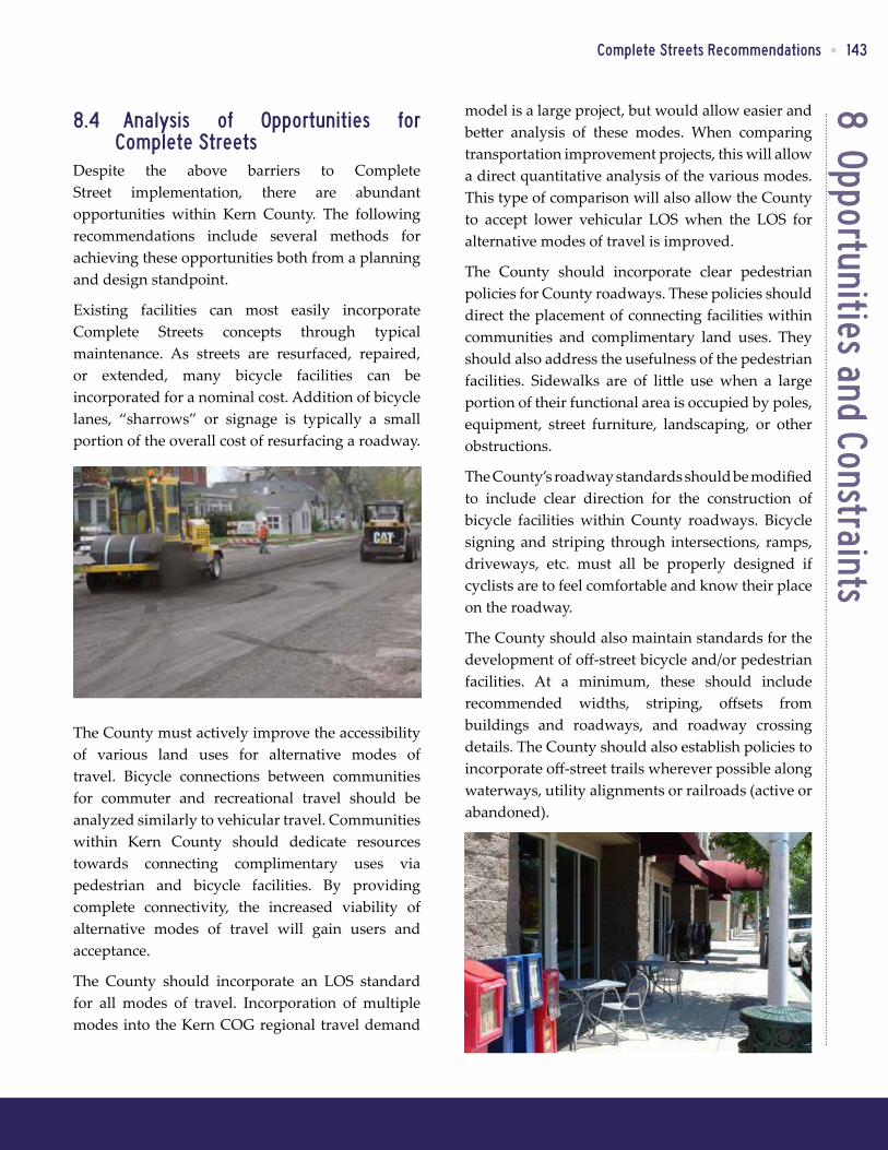
Existing facilities can most easily incorporate Complete Streets concepts through typical maintenance. As streets are resurfaced, repaired, or extended, many bicycle facilities can be incorporated for a nominal cost. Addition of bicycle lanes, “sharrows” or signage is typically a small portion of the overall cost of resurfacing a roadway.
The County must actively improve the accessibility of various land uses for alternative modes of travel. Bicycle connections between communities for commuter and recreational travel should be analyzed similarly to vehicular travel. Communities within Kern County should dedicate resources towards connecting complimentary uses via pedestrian and bicycle facilities. By providing complete connectivity, the increased viability of alternative modes of travel will gain users and acceptance.
The County should incorporate an LOS standard for all modes of travel. Incorporation of multiple modes into the Kern COG regional travel demand

144 • Kern Council of Governments
This page intentionally left blank.

9 Recomm
endations and Design GuidelinesComplete Streets Recommendations • 145
9. Complete Streets Recommendations and Design Guidelines
9.1 Policy RecommendationsThe following policies are recommended for the implementation of Complete Streets in Kern County:
• Develop a comprehensive bikeway and pedestrian network that is feasible, fundable over the life of the Plan, and that serves bicyclist’s needs for all trip purposes.
• Prepare and maintain a Bicycle Master Plan that identifies existing and future needs, provides specific recommendations for facilities and programs, and identifies priorities and funding sources for implementation.
• Update the Bicycle Master Plan to meet requirements of Bicycle Transportation Account (BTA) funding at least every five years.
• Maintain and improve the quality, operation, and integrity of the bicycle and pedestrian network and support facilities.
• Increase public awareness of the benefits of bicycling and of available bicycle and trail facilities and programs.
• Bicycle signage and route maps should be made readily available and accessible to the public.
• As land uses within undeveloped areas of unincorporated communities are developed, bicycle, pedestrian, and transit facilities should be considered as a joint effort between the City and private development.
• These facilities should be required when connecting existing or planned facilities.
• The County should work with development to provide bicycle parking within reasonable walking distances to all destinations within Downtown. Bicycle parking should be as
convenient as, or more so than, automobile parking.
• Coordinate roadway and development projects with the transit agency serving each area to provide the necessary amenities prior to construction.
• Incorporate bicycle, pedestrian, and transit improvements into Transportation Impact Fee programs when not solely used for recreation.
• Closure of gaps in pedestrian, bicycle, or transit network
• Prioritize Complete Streets projects based on the following criteria:
□ Expand existing network □ Ease of implementation □ Access to activity centers,
neighborhoods, or regional network □ Promote alternative travel use
9.2 Infrastructure and Facility Treatments
Chapter 7 of this report includes a number of facility treatments to incorporate pedestrian, bicycle, transit and safety enhancements to roadways. These treatments provide an added measure of comfort and safety for these modes while retaining the ability for vehicles to travel without significant encumbrance. The goal of any Complete Street should be the mobility and safety of all roadway users.
These treatments provide varied levels of effectiveness, safety, and cost. Tables 9-1 through 9-4 provide weighting of each of these treatments and factors.
9.2.1 Pedestrian TreatmentsTreatments such as landscaping, pedestrian signals, and curb extensions all provide high levels of protection for pedestrians as well as enhance the experience of pedestrian travel. Landscaping may be used only as an aesthetic treatment, or

9 R
ecom
men
datio
ns a
nd D
esig
n Gu
idel
ines
146 • Kern Council of Governments
9.2.2 Bicycle TreatmentsAs with pedestrian enhancements, some treatments increase safety and are highly effective, while others may provide improvements in only one area. All treatments that result in a significant change in the roadway solely to the benefit of the cyclist, (e.g., bicycle signals and cycle tracks) should be installed with care and satisfaction of applicable criteria (warrants). Bicycle improvements installed without meeting minimum warrants may cause drivers to disregard them due to minimal use or installation in an area that significantly alters travel behavior.
Regarding costs, the largest factor in many bicycle enhancements is the availability of right-of-way. Many pavement marking enhancements (e.g. bicycle lanes, shared roadways, bike boxes) can be installed at minimal cost during a typical roadway resurfacing project. However, when additional right-of-way is needed, the cost to purchase land and install additional paved area can result in significant costs. A solution to this in many cases is the removal or reduction of on-street parking or travel lane widths.
when placed between the street and sidewalk, a buffer zone for an additional level of safety. Curb extensions typically increase safety and comfort, except when designed without a grade separation from the roadway and vehicles may cut across them for tighter turns. Other treatments such as street furniture curb ramps, and push buttons (at signals) enhance the level of comfort for pedestrians, but by themselves, do not provide a significant level of safety improvement.
Costs vary for each type of implementation, and often the largest factor is the incorporation of the treatments into existing infrastructure. For instance, curb extensions may typically affect not only right-of-way, but drainage and parking as well. Reducing the number of driveways may be easily accomplished in undeveloped areas, but modifying existing access may prove difficult and costly in developed areas. Installation of pedestrian push buttons is less when installed with the traffic signal, but can increase dramatically when added to existing signals.
Table 9-1: Effectiveness of Pedestrian Facility TreatmentsTreatment Reduces Vehicle
SpeedSafety Increase Level of
Effectiveness*Cost
Sidewalk No Moderate Moderate Low
High Visibility Crosswalks Yes Moderate-High Moderate Low
Pedestrian Signals Yes High High High
Street Furniture No Low Low Low
Landscaping Maybe Low-High Moderate-High Low-Moderate
Street Lighting No Moderate Moderate Moderate
Limit Driveways Maybe Moderate-High High Low-High
Curb Extensions Yes High High High
Curb Ramps No Moderate Moderate-High Low-Moderate
Pedestrian Refuge Islands Maybe High High Moderate
Triangular Median Islands Maybe High High Moderate-High
Pedestrian Push Buttons No Low-Moderate Moderate Low-Moderate
Pedestrian Countdown Signal No High High Moderate*Note: Level of effectiveness refers to the enhancement of pedestrian experience and level of compliance (safety, comfort, reaction of other modes of travel, etc.)

9 Recomm
endations and Design GuidelinesComplete Streets Recommendations • 147
uncertain benefits, but is more effective when installed in or near destination areas where users are more likely to switch to short length trips. Trip information is also helpful to some passengers, but the majority of transit users will research or know their planned route ahead of time.
9.2.4 Roadway TreatmentsAs previously mentioned, curb extensions, reduced curb radii and chicanes/chokers can provide highly effective treatments, except when a grade separation or barrier (planter, etc.) is not present to prohibit wheel paths from encroaching onto the pedestrian traveled way. Speed feedback signs provide an active reminder to motorists of the speed limit which increases the likelihood of compliance. Rumble strips alert motorists when they are drifting off of the roadway and can be an effective safety measure for motorist and bicycle conflicts.
9.2.3 Transit TreatmentsThe transit facility treatments shown in Table 9-3 provide little in the way of safety by themselves. The level of safety is determined more by the separation of these enhancements from the roadway as well as the adjacent pedestrian and bicycle facilities. For instance, a shelter by itself provides a small safety increase through visibility when installed on an unimproved roadway shoulder, and little to no safety increase when installed on a sidewalk in a bus turnout.
However, all of the transit facility treatments provide improved experiences for the transit user. Shelters and seating provide comfort to the waiting passengers and may attract users; whereas, a bus stop with no amenities may cause riders to find an alternate mode of travel, especially in inclement weather conditions. Bicycle storage provides
Table 9-2: Effectiveness of Bicycle Facility TreatmentsTreatment Reduces
Vehicle SpeedSafety Increase Level of
Effectiveness*Cost
Striped Bike Lanes Maybe Moderate Moderate Low-Moderate
Buffered Bike Lanes Yes High High Moderate
Cycle Tracks Yes High High Moderate-High
Shared Roadways Maybe Low-Moderate Moderate Low-Moderate
Shoulder Bikeways No Low-Moderate Low-Moderate Low
Bicycle Detection No Moderate High Moderate
Intersection Crossing Markings Maybe Moderate-High High Moderate
Bike Boxes Maybe Moderate High Low
Bicycle Signals Yes High High High *Note: Level of effectiveness refers to the enhancement of the cyclists’ experience and level of compliance (safety, comfort, reaction of other modes of travel, etc.)
Table 9-3: Effectiveness of Transit Facility TreatmentsTreatment Reduces Vehicle
SpeedSafety Increase Level of
Effectiveness*Cost
Shelter Maybe Moderate High Moderate
Seating No Low Moderate Low
Bicycle Storage No Low Low-High Moderate
Trip Information No Low Moderate Low *Note: Level of effectiveness refers to the enhancement of experience and level of compliance (safety, comfort, reaction of other modes of travel, etc.)

9 R
ecom
men
datio
ns a
nd D
esig
n Gu
idel
ines
148 • Kern Council of Governments
in the latest Highway Capacity Manual update.” (Kern COG Regional Transportation Plan, p 4-109.) Most are familiar with “level of service” as applied to traffic conditions as a measure of the motorist’s perception of traffic operations along roadways and at intersections. Multimodal level of service (MMLOS) expands those measures to evaluate all major modes of travel: walking, biking, taking transit, and driving. MMLOS also provides a means to better understand the trade-offs among travel modes as they share the public right-of-way, while “non-motorized mode”-specific measures provide a means of measuring the performance or quality of the bicycling and walking environment. This effort provides an opportunity to expand the current performance measures of peak hour traffic congestion and frequencies and routes of transit service to include measures that address bicycling and walking conditions.
Performance measures for bikes and pedestrians have been developed, providing several options for multimodal level of service standards for consideration:
Costs of roadway treatments are typically high due to demolition of existing facilities to install the planned enhancement. Installation of chicanes or traffic circles may also require significant traffic control costs during demolition and installation. Costs for speed humps can vary significantly depending on the material used. Striping and signage treatments are typically low and may be completed along with routine maintenance. Advance stop bars and yield lines may be installed at minimal expense except when they require the relocation of traffic signal detectors.
9.3 Multimodal Level of Service Recommendations
One of the biggest barriers in the implementation of Complete Streets is the current practice of using traffic level of service (LOS) standards to measure traffic congestion on the roadway network as often times the only performance measure. However, within Kern County, “jurisdictions are encouraged to incorporate multimodal level of service standards as appropriate for each community facility type, place type, and corridor type, as recommended
Table 9-4: Effectiveness of Roadway Facility TreatmentsTreatment Reduces Vehicle
SpeedSafety
IncreaseLevel of
Effectiveness*Cost
Advance Stop Bar / Yield Line Maybe Moderate-High High Low-High
Curb Radii Reduction Yes Moderate High Moderate-High
Speed Humps / Speed Tables Yes Moderate-High High Moderate
Chicanes / Chokers Yes High High High
Speed Feedback Signs Maybe Moderate-High Moderate-High Low-Moderate
Traffic Circles Yes High Moderate-High Moderate-High
On-Street Parking Yes Negative1-Moderate Moderate Moderate-High
Wayfinding Signage No Low Moderate Low-Moderate
Road Diet Maybe Moderate High Moderate
Roadway Widening Yes Low-High Low-High2 High*Note: Level of effectiveness refers to the enhancement of pedestrian experience and level of compliance (safety, comfort, reaction of other modes of travel, etc.) 1Negative = reduced safety to cyclists in some instances2 Depends upon the pedestrian/bicycle facility installed as a part of the widening, widening traffic lanes may reduce these factors.

9 Recomm
endations and Design GuidelinesComplete Streets Recommendations • 149
9.3.1 2010 Highway Capacity Manual Multimodal LOS
Recently, the National Cooperative Highway Research Program (NCHRP) developed and calibrated a method for evaluating the multimodal level of service (MMLOS) provided by different urban street designs and operations. The method provides an LOS grade for each user type – motorist, transit passenger, bicyclist, and pedestrian – for a roadway corridor based on the user’s perceptions of the quality of service provided by the street. The MMLOS method is designed for evaluating “complete streets,” context-sensitive design alternatives, and smart growth from the perspective of all major roadway users on the urban street.
The 2010 Highway Capacity Manual adopted much of the NCHRP report for its multimodal level of service methodology. For bicyclists and pedestrians, the LOS grades correspond to numerical scores, which are calculated using a variety of inputs that cover the facility design, facility controls, and volumes. The thresholds for each LOS grade are shown in Table 9-5 with a general description of what the scores represent for these alternative modes.
By applying the MMLOS methodology, the Bicyclist LOS is a weighted combination of the bicyclists’ experience at intersections and on street segments in between the intersections. LOS A represents the best performance, with bicyclists feeling the most safe and comfortable as they travel through the intersections and along the segment, whereas LOS F represents the worst performance with bicyclists feeling the least safe and comfortable as they travel through the intersections and along the segment. The numerical score is dependent upon the width of the paving between the outside lane stripe and the edge of pavement (which includes parking lane and bike lane, if present) as well as the pavement condition. Vehicle speeds and volumes will also affect the bicycle segment LOS as well as the number
• Pedestrian Performance Measures – Several factors come into play when considering the pedestrian environment: ease at which a street can be crossed, including wait time and crossing distances; sidewalk presence and continuity; street density; vehicle volumes and speeds; percent of heavy vehicles; and topography. The 2010 Highway Capacity Manual, in addition to multimodal procedures, includes procedures to evaluate pedestrian LOS based on capacity and pedestrian density for areas of high pedestrian volumes, and on shared-use trails based on bicycle and pedestrian volumes. Pedestrian measures could apply across an entire district, be specific to a corridor, or measure the quality of a walk trip to access transit. The measures consider physical characteristics, location factors, and user factors. Others, like the Pedestrian Environmental Quality Index, measure the quality of walk trips.
• Bicycle Performance Measures – Bicycle LOS or other methods, such as the Bicycle Environmental Quality Index (BEQI), or Bicycle Compatibility Index (BCI), are based on measurable traffic and roadway factors, such as vehicle speed, volumes, and surface conditions. They provide a means for quantifying bicyclists’ comfort level for specific roadway geometries and traffic conditions. “Compatibility” can be defined by factors such as bike lane presence and width, roadway width, traffic volumes, pavement surface conditions, motor vehicle’s speed and type, and on-street parking.
This list touches upon some of the various measures available when considering multimodal level of service standards for Kern County. The County could adopt multimodal LOS standards using the latest 2010 Highway Capacity Manual or these other quality of service standards that have been developed for bicyclists and pedestrians.

9 R
ecom
men
datio
ns a
nd D
esig
n Gu
idel
ines
150 • Kern Council of Governments
included in the latest 2010 Highway Capacity Manual is most sensitive to traffic volumes, buffer width between sidewalk and traffic, number of street trees, and parking occupancy. As with the Bicyclist LOS, LOS A represents the best performance with pedestrians feeling the most safe and comfortable as they travel along the segment, whereas LOS F represents the worst performance with pedestrians feeling the least safe and comfortable as they travel along the segment. Using this methodology, a pedestrian LOS C standard might be represented by a tree-lined street where the traffic lane is separated from the sidewalk by parked cars.
While detailed collision data is not specifically incorporated as part of the 2010 HCM bicycle and pedestrian LOS calculations, the perceived safety factors are accounted for by the lateral separation of the walkway from moving vehicles, buffer zone elements, and the number of potential conflicts from turning vehicles at intersections.
9.3.2 Issues with Development of Multimodal Performance Measures
Issues that arise in the development of the multimodal performance standards include:
• Consistency with current traffic LOS standards and transit performance measures.
of access points (driveways and unsignalized cross streets) they encounter. For example, a Bicyclist LOS C for a roadway with a bike lane will require good pavement conditions.
Pedestrian LOS is based on the worst LOS between two methods: pedestrian density, as described in Chapter 18 of the Highway Capacity Manual, or a weighted combination of non-density factors related to pedestrians’ experience on the street segment and at intersections, as well as roadway crossing difficulty. The density-based LOS thresholds are shown in Table 9-6.
Table 9-6: Pedestrian LOS Thresholds for Walkway DensityLOS Walkway Density
(in square feet per person)
Numerical Score
A >60 ≤2.00
B >40 >2.00 and ≤2.75
C >24 >2.75 and ≤3.50
D >15 >3.50 and ≤4.25
E >8 >4.25 and ≤5.00
F ≤8 >5.00
As a measure of the quality of the pedestrian’s experience, the Pedestrian LOS methodology
Table 9-5: Definition of Multimodal Level of Service (MMLOS)LOS Numerical Score Bicycle Pedestrian
A ≤2.00Few driveway and cross street conflicts, good pavement condition, ample width of outside lane, including parking and bike lanes
Low traffic volumes, wide buffer separating sidewalk from traffic, numerous street trees, high parking occupancy
B >2.00 and ≤2.75
C >2.75 and ≤3.50
D >3.50 and ≤4.25
E >4.25 and ≤5.00
F >5.00Poor pavement condition, narrow width of outside lane, frequent driveways and cross streets
High traffic volumes, limited buffer separating sidewalk from traffic, few street trees, low parking occupancy
Source: 2010 Highway Capacity Manual

9 Recomm
endations and Design GuidelinesComplete Streets Recommendations • 151
9.4 Level of Service Analysis for Bicycle Design Standards
For the purposes of this working paper, a link level analysis was performed using the 2010 Highway Capacity Manual MMLOS methodology to analyze the compatibility of the model design standards presented in the appendices. Using the cross-sections, the bicycle LOS and pedestrian LOS were determined for existing and proposed conditions. A range of directional traffic volumes from 250 to 2,000 vehicles per hour and speeds of 25 mph and 45 mph for the facilities were tested for each bike lane design standard to indicate the potential change in bicycle and pedestrian levels of service with and without the proposed bike lane. Tables 9-7, 9-8, 9-9, and 9-10 summarize the results of the link level analysis for each of the design standards detailed in the appendices section “Class II Bikeway: Retrofitting Existing Streets” assuming an average vehicle speed of 45 mph.
9.4.1 Class II Bikeway: Retrofitting Existing Streets, Roadway Widening
Table 9-7 shows Pedestrian and Bicyclist LOS results when the roadway is widened to accommodate the Class II bikeway and a sidewalk when compared to existing conditions without a bike lane and/or sidewalk. It also shows the results with and without on-street vehicle parking. Key findings are that this design:
• Improves the Bicyclist LOS by at least one letter grade depending upon the directional vehicle volumes.
• Improves the Pedestrian LOS dramatically by providing the sidewalk, especially with the additional separation from moving vehicles with the on-street parking.
The roadway widening benefits both the bicyclist and pedestrian, particularly on lower volume two lane roadways.
• Prioritization of modes based on the user’s need.
• Context for using bike and pedestrian LOS standards.
Each of these issues is discussed below.
Maintaining LOS standards would provide consistency with the current traffic LOS and transit measures in the RTP, but could be augmented with bicycle and pedestrian measures. The Bicyclist LOS and Pedestrian LOS standards could apply to all arterial and collector roadways, key roadways, such as designated multimodal corridors or CMP roadways, or a subset of the Congestion Management System. However, defining standards for these other modes may result in situations where a corridor meets the standard for some modes, but not all modes.
Flexible LOS standards would take into account motorist LOS but only as one of a number of context-related factors to better understand the trade-offs among travel modes inherent in street design. One approach may be to establish mode priorities. Some roadways serve as key development corridors, but also as the main through route for both motorists and bicyclists. As such, there will need to be a balance of priorities that can be measured using MMLOS to quantify the trade-offs among these competing modes. For example, for arterials serving mixed use, higher density development, the priority could be established for pedestrian LOS that would allow for a substandard motorist LOS.
In establishing multimodal LOS standards, the context needs to be considered. MMLOS may best be applied to specific corridors that serve multiple modes of travel and are constrained by development, such that roadway widening is not feasible. A Bicyclist LOS may only apply to corridors with existing or proposed bike lanes as a way to measure the effects of investment in bike lanes or Pedestrian LOS may be applied in areas with high pedestrian activity, such as downtown or near schools.

9 R
ecom
men
datio
ns a
nd D
esig
n Gu
idel
ines
152 • Kern Council of Governments
9.4.3 Class II Bikeway: Retrofitting Existing Streets, Lane Reconfiguration
Table 9-9 shows Pedestrian and Bicyclist LOS results when the travel lanes are reconfigured to accommodate the Class II bikeway when compared to existing conditions without a bike lane. Key findings are that this design:
• Improves the Bicyclist LOS by two letter grades for the range of direction vehicle volumes.
• Degrades the Pedestrian LOS, particularly at higher volumes.
The lane reconfiguration benefits only the bicyclist. The road diet, which consolidates traffic to a single travel lane, results in a degraded Pedestrian LOS due to more vehicles traveling in closer proximity to the walkway.
9.4.2 Class II Bikeway: Retrofitting Existing Streets, Lane Narrowing
Table 9-8 shows Pedestrian and Bicyclist LOS results when the vehicle lane is narrowed to accommodate the Class II bikeway when compared to existing conditions without a bike lane. Key findings are that this design:
• Improves the Bicyclist LOS by at least one letter grade depending upon the directional vehicle volumes.
• Results in minor changes to the Pedestrian LOS at low vehicle volumes and no changes to Pedestrian LOS at higher volumes.
The lane narrowing primarily benefits the bicyclist. In this case, pedestrians already have a sidewalk without the changes to accommodate the bike lane.
Road
way
Wid
enin
g
Cross SectionVolume
250 500 750 1000 1250 1500 1750 2000Bike (EB)
with parking
Existing 3.80 (D) 4.15 (D) 4.35 (E) 4.50 (E) 4.61 (E) 4.71 (E) 4.78 (E) 4.85 (E)
Proposed 2.82 (C) 3.17 (C) 3.38 (C) 3.52 (D) 3.64 (D) 3.73 (D) 3.81 (D) 3.88 (D)
Ped (EB) with
parking
Existing 4.10 (D) 4.67 (E) 5.24 (F) 5.81 (F) 6.38 (F) 6.94 (F) 7.51 (F) 8.08 (F)
Proposed 1.96 (A) 2.53 (B) 3.09 (C) 3.66 (D) 4.23 (D) 4.80 (E) 5.37 (F) 5.94 (F)
Bike (WB) no
parking
Existing 3.80 (D) 4.15 (D) 4.35 (E) 4.50 (E) 4.61 (E) 4.71 (E) 4.78 (E) 4.85 (E)
Proposed 2.04 (B) 2.39 (B) 2.60 (B) 2.75 (B) 2.86 (C) 2.95 (C) 3.03 (C) 3.10 (C)
Ped (WB) no
parking
Existing 4.10 (D) 4.67 (E) 5.24 (F) 5.81 (F) 6.38 (F) 6.94 (F) 7.51 (F) 8.08 (F)
Proposed 2.45 (B) 3.01 (C) 3.58 (D) 4.15 (D) 4.72 (E) 5.29 (F) 5.86 (F) 6.43 (F)
Table 9-7: Class II Bikeway: Retrofitting Existing Streets, Roadway WideningLa
ne N
arro
win
g
Cross SectionVolume
250 500 750 1000 1250 1500 1750 2000
Bike (EB)Existing 4.14 (D) 4.49 (E) 4.70 (E) 4.84 (E) 4.96 (E) 5.05 (F) 5.13 (F) 5.20 (F)
Proposed 3.21 (C) 3.56 (D) 3.77 (D) 3.91 (D) 4.03 (D) 4.12 (D) 4.20 (D) 4.27 (E)
Ped (EB)Existing 2.00 (B) 2.57 (B) 3.14 (C) 3.71 (D) 4.28 (E) 4.85 (E) 5.42 (F) 5.99 (F)
Proposed 1.98 (A) 2.55 (B) 3.12 (C) 3.68 (D) 4.25 (E) 4.82 (E) 5.39 (F) 5.96 (F)
Bike (WB)Existing 4.14 (D) 4.49 (E) 4.70 (E) 4.84 (E) 4.96 (E) 5.05 (F) 5.13 (F) 5.20 (F)
Proposed 3.21 (C) 3.56 (D) 3.77 (D) 3.91 (D) 4.03 (D) 4.12 (D) 4.20 (D) 4.27 (E)
Ped (WB)Existing 2.00 (B) 2.57 (B) 3.14 (C) 3.71 (D) 4.28 (E) 4.85 (E) 5.42 (F) 5.99 (F)
Proposed 1.98 (A) 2.55 (B) 3.12 (C) 3.68 (D) 4.25 (E) 4.82 (E) 5.39 (F) 5.96 (F)
Table 9-8: Class II Bikeway: Retrofitting Existing Streets, Lane Narrowing

9 Recomm
endations and Design GuidelinesComplete Streets Recommendations • 153
The parking reduction benefits the bicyclist. The reduction of parking on one side shifts the center line which affects the separation of pedestrian from moving traffic resulting in a degraded Pedestrian LOS.
9.5 County Design StandardsAs noted in Chapter 6, the Kern County Design Standards provide information including cross sectional details for each roadway type and more information on incorporating bicycle facilities than many adjacent city and county documents. Following on from the recommendation made in previous sections and to address the few gaps in bicycle facility design, new and modified designs shown in Figures 9-1 through 9-6 are proposed for incorporation into the standards.
9.4.4 Class II Bikeway: Retrofitting Existing Streets, Parking Reduction
Table 9-10 shows Pedestrian and Bicyclist LOS results when on-street parking occupancies are reduced or removed to accommodate the Class II bikeway when compared to existing conditions without a bike lane. Key findings are that this design:
• Improves the Bicyclist LOS by one or more letter grades depending upon the vehicle volumes and parking by direction.
• Results in minor changes to the Pedestrian LOS at low vehicle volumes, no changes to Pedestrian LOS at higher volumes for the side with on-street parking.
• Results in no change to or degrades the Pedestrian LOS, depending upon the vehicle volume for the side without on-street parking.
Lane
Rec
onfig
urat
ion
Cross SectionVolume
250 500 750 1000 1250 1500 1750 2000
Bike (EB)Existing 3.97 (D) 4.32 (E) 4.52 (E) 4.67 (E) 4.78 (E) 4.87 (E) 4.95 (E) 5.02 (F)
Proposed 2.50 (B) 2.85 (C) 3.06 (C) 3.21 (C) 3.32 (C) 3.41 (C) 3.49 (C) 3.56 (D)
Ped (EB)Existing 2.39 (B) 2.68 (B) 2.96 (C) 3.25 (C) 3.53 (D) 3.82 (D) 4.10 (D) 4.38 (E)
Proposed 2.48 (B) 3.05 (C) 3.62 (D) 4.19 (D) 4.76 (E) 5.33 (F) 5.90 (F) 6.46 (F)
Bike (WB)Existing 3.97 (D) 4.32 (E) 4.52 (E) 4.67 (E) 4.78 (E) 4.87 (E) 4.95 (E) 5.02 (F)
Proposed 2.50 (B) 2.85 (C) 3.06 (C) 3.21 (C) 3.32 (C) 3.41 (C) 3.49 (C) 3.56 (D)
Ped (WB)Existing 2.39 (B) 2.68 (B) 2.96 (C) 3.25 (C) 3.53 (D) 3.82 (D) 4.10 (D) 4.38 (E)
Proposed 2.48 (B) 3.05 (C) 3.62 (D) 4.19 (D) 4.76 (E) 5.33 (F) 5.90 (F) 6.46 (F)
Table 9-9: Class II Bikeway: Retrofitting Existing Streets, Lane ReconfigurationPa
rkin
g Re
duct
ion
Cross SectionVolume
250 500 750 1000 1250 1500 1750 2000Bike (EB)
with parking
Existing 4.56 (E) 4.91 (E) 5.12 (F) 5.26 (F) 5.38 (F) 5.47 (F) 5.55 (F) 5.62 (F)
Proposed 3.39 (C) 3.74 (D) 3.95 (D) 4.09 (D) 4.21 (D) 4.30 (E) 4.38 (E) 4.45 (E)
Ped (EB) with
parking
Existing 2.06 (B) 2.63 (B) 3.20 (C) 3.77 (D) 4.34 (E) 4.91 (E) 5.48 (F) 6.05 (F)
Proposed 1.99 (A) 2.56 (B) 3.13 (C) 3.70 (D) 4.27 (E) 4.84 (E) 5.41 (F) 5.97 (F)
Bike (WB) no
parking
Existing 4.56 (E) 4.91 (E) 5.12 (F) 5.26 (F) 5.38 (F) 5.47 (F) 5.55 (F) 5.62 (F)
Proposed 2.72 (B) 3.07 (C) 3.27 (C) 3.42 (C) 3.53 (D) 3.63 (D) 3.70 (D) 3.77 (D)
Ped (WB) no
parking
Existing 2.06 (B) 2.63 (B) 3.20 (C) 3.77 (D) 4.34 (E) 4.91 (E) 5.48 (F) 6.05 (F)
Proposed 2.50 (B) 3.07 (C) 3.64 (D) 4.21 (D) 4.77 (E) 5.34 (F) 5.91 (F) 6.48 (F)
Table 9-10: Class II Bikeway: Retrofitting Existing Streets, Parking Reduction

9 R
ecom
men
datio
ns a
nd D
esig
n Gu
idel
ines
154 • Kern Council of Governments
Figure 9-1: Kern County Roadway Standards, Commercial Street Alternatives
Figure 9-2: Kern County Roadway Standards, Arterial Highway Bike Route
Note: Sidewalk patterns below 10 feet may create sight distance problems for drivers, cyclists and pedestrians at driveways.

9 Recomm
endations and Design GuidelinesComplete Streets Recommendations • 155
Figure 9-3: Kern County Roadway Standards, Arterial Highway Bike Trail
Figure 9-4: Kern County Roadway Standards, Off-Street Trail Standards
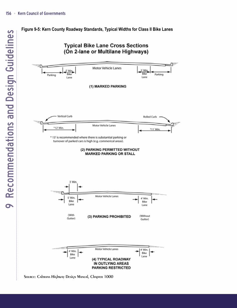
9 R
ecom
men
datio
ns a
nd D
esig
n Gu
idel
ines
156 • Kern Council of Governments
Figure 9-5: Kern County Roadway Standards, Typical Widths for Class II Bike Lanes

9 Recomm
endations and Design GuidelinesComplete Streets Recommendations • 157
Figure 9-6: Kern County Roadway Standards, Bike Lane Transitions at Intersections

9 R
ecom
men
datio
ns a
nd D
esig
n Gu
idel
ines
158 • Kern Council of Governments
9.6 Innovative FacilitiesThis section presents design guidelines for innovative complete streets treatments. The following guidelines should be assessed and implemented on a case-by-case basis depending on the existing conditions of the project site. They are organized by pedestrian facilities, bicycle treatments, transit treatments, and roadway treatments.
9.6.1 ApplicabilityThese guidelines are recommendations and do not constitute a standard which must be followed, or suggest that the treatments are necessarily approved by Kern County. They represent the most innovative practices now being undertaken elsewhere in the United States. Guidelines may be used alongside sound traffic engineering judgment to inform the provisions for bicycling. Where there is a discrepancy with a requirement outlined in an applicable California manual, then that manual takes precedence over the guideline.
For geometric design and layout of bicycle facilities on state highways, the California Streets and Highways Code Section 890.6 specifies that the California Department of Transportation (Caltrans) “in cooperation with county and city governments, shall establish minimum safety design criteria for the planning and construction of bikeways and roadways where bicycle travel is permitted. The criteria shall include, but not be limited to, the design speed of the facility, minimum widths and clearances, grade, radius of curvature, pavement surface, actuation of automatic traffic control devices, drainage, and general safety.” These criteria are contained within the California Highway Design Manual (HDM) Chapter 1000. Although the HDM applies to state highways only (not local streets), Section 891 currently requires cities, counties, and other agencies to utilize the HDM safety design criteria for bikeways or roadways where bicycle
travel is permitted. The HDM “is neither intended as, nor does it establish, a legal standard...the standards, procedures and requirements...herein are for the information and guidance of the officers and employees of the Department.” In other words, the HDM is not a substitute for the application of sound engineering judgment.
For signs and markings, Section 890.8 specifies that Caltrans “shall establish uniform specifications and symbols for signs, markers, and traffic control devices to designate bikeways, regulate traffic, improve safety and convenience for bicyclists, and alert pedestrians and motorists of the presence of bicyclists on bikeways and on roadways where bicycle travel is permitted.” These specifications are contained within the California Manual of Uniform Traffic Control Devices (CA-MUTCD). The CA-MUTCD is applicable to all public streets, highways, pedestrian facilities and bikeways in the state, but not to private roads.
Section 18 of the CA-MUTCD states that “in cases involving Federal-aid projects for new highway or bikeway construction or reconstruction, the traffic control devices installed (temporary or permanent) shall be in conformance with the most recent edition of the National MUTCD before that highway is opened or re-opened to the public for unrestricted travel [23 CFR 655.603(d)(2) and (d)(3)].”
Some of the designs presented in this chapter are currently approved or in trial at the federal or state level. If adopted at the federal level, the Code of Federal Regulations requires that the CA-MUTCD be in substantial conformance with changes to the National MUTCD within 2 years of the effective date of the Final Rule for the changes.
Innovations could be implemented through an experimental trial, which generally requires the collection of before and after treatment data and a potentially lengthy approval process. Assembly Bill 819: Bikeways was enrolled on August 22, 2012. If signed and chartered, this legislation would establish procedures for granting exceptions to the HDM and CA-MUTCD.

9 Recomm
endations and Design GuidelinesComplete Streets Recommendations • 159
SidewalksDesign Summary
Discussion
Recommended widths enables two pedestrians (including wheelchair
users) to walk side-by-side, or to pass each other comfortably.
Proposed sidewalk guidelines apply to new development and depend
on available street width, motor vehicle volumes, surrounding land
uses, and pedestrian activity levels. Standardizing sidewalk guidelines
for different areas of the region, dependent on the above listed
factors, ensure a minimum level of quality for all sidewalks. As part of
a roadway reconstruction project on a street with a narrow sidewalk
corridor, planners should analyze the impact of reclaiming a portion
of the existing right-of-way. If this proves impractical, the feasibility
of acquiring additional right-of-way should be examined. Acquisition
should be considered where cost is reasonable in proportion to the
overall project cost.
Guidance
Ū United States Access Board. (2002). Accessibility Guidelines for Buildings and Facilities.
Ū United States Access Board. (2007). Public Rights-of-Way Accessibility Guidelines (PROWAG).
Curb Planting Strip (buffer)*
Sidewalk Width
Arterials and Collectors
1 ft 6-8 ft 8 ft †
Local Streets 0-1 ft 6-8 ft 5 ft †
Bus Stops 1 ft varies 5’ x 8’ area ‡
Commercial Walkways
1 ft 6-8 ft 6-10 ft
Mixed Use Center Streets
1 ft 6-8 ft 10-12 ft
* In constrained locations, the full sidewalk width should be provided, with a reduced-width planting strip/buffer. † Note: short sidewalk segments can have narrower widths in physically-constrained areas.‡ Required minimum by ADA† Sidewalk patterns below 10 feet may create sight distance problems for drivers, cyclists and pedestrians at driveways.
A well-designed sidewalk provides plenty of pedestrian space.
A landscaping buffer between the sidewalk and the street provides the pedestrian with a protected space from motor vehicle traffic.
9.6.2 Design Guidelines for Pedestrian Facilities

9 R
ecom
men
datio
ns a
nd D
esig
n Gu
idel
ines
160 • Kern Council of Governments
High Visibility CrosswalksDesign Summary
Ū See MUTCD for pavement marking spacing.
Ū Mark all crosswalks at signalized intersections. At un-signal-ized intersections, mark crosswalks under the following conditions:
Ū At a complex intersection, to orient pedestrians in finding their way across.
Ū At an offset intersection, to show pedestrians the shortest route across traffic with the least exposure to vehicular traffic and traffic conflicts.
Ū At an intersection with visibility constraints, to position pedestrians where they can best be seen by oncoming traffic.
Ū At mid-block locations, mark crosswalks where:
Ū There is a demand for crossing AND
Ū There are no nearby marked crosswalks.
DiscussionMarking crosswalks, especially high visibility crosswalks, signals
to drivers that they should stop for pedestrians, and encourages
pedestrians to cross at safer locations. Crosswalk markings also
indicate to pedestrians the appropriate route across traffic, to
facilitate crossing by the visually impaired and remind turning drivers
of potential conflicts with pedestrians.
Use ladder pavement markings at crossings with high pedestrian use or
where vulnerable pedestrians are expected, including:
Ū School crossings.
Ū Across arterial streets for pedestrian-only signals.
Ū At mid-block crosswalks.
Guidance
Ū United States Access Board. (2007). Public Rights-of-Way Accessibility Guidelines (PROWAG).
Ū FHWA. (2005). Safety Effects of Marked Versus Unmarked Crosswalks at Uncontrolled Locations Final Report and Recommended Guidelines. http://www.fhwa.dot.gov/publications/research/safety/04100/
Ladder / zebra style crosswalks increase the visibility of pedestrians to drivers because the striping is in the same direction
as the motorist path of travel.
Marking high visibility crosswalks at schools help children cross at safer locations.
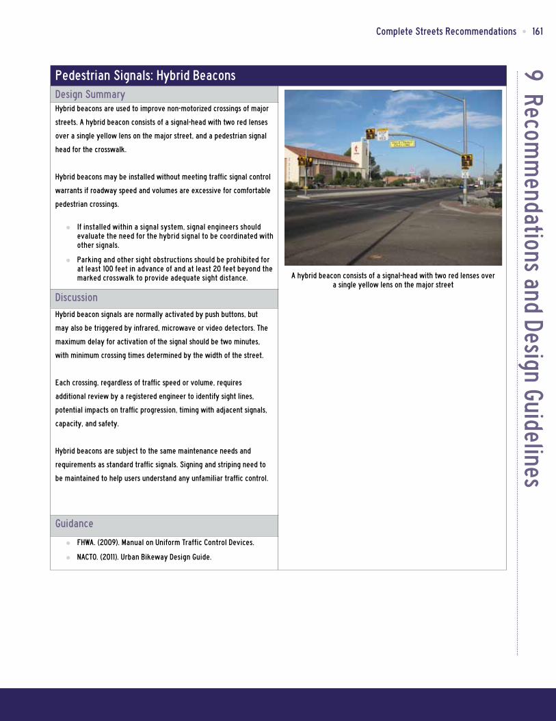
9 Recomm
endations and Design GuidelinesComplete Streets Recommendations • 161
Pedestrian Signals: Hybrid BeaconsDesign SummaryHybrid beacons are used to improve non-motorized crossings of major
streets. A hybrid beacon consists of a signal-head with two red lenses
over a single yellow lens on the major street, and a pedestrian signal
head for the crosswalk.
Hybrid beacons may be installed without meeting traffic signal control
warrants if roadway speed and volumes are excessive for comfortable
pedestrian crossings.
Ū If installed within a signal system, signal engineers should evaluate the need for the hybrid signal to be coordinated with other signals.
Ū Parking and other sight obstructions should be prohibited for at least 100 feet in advance of and at least 20 feet beyond the marked crosswalk to provide adequate sight distance.
DiscussionHybrid beacon signals are normally activated by push buttons, but
may also be triggered by infrared, microwave or video detectors. The
maximum delay for activation of the signal should be two minutes,
with minimum crossing times determined by the width of the street.
Each crossing, regardless of traffic speed or volume, requires
additional review by a registered engineer to identify sight lines,
potential impacts on traffic progression, timing with adjacent signals,
capacity, and safety.
Hybrid beacons are subject to the same maintenance needs and
requirements as standard traffic signals. Signing and striping need to
be maintained to help users understand any unfamiliar traffic control.
Guidance
Ū FHWA. (2009). Manual on Uniform Traffic Control Devices.
Ū NACTO. (2011). Urban Bikeway Design Guide.
A hybrid beacon consists of a signal-head with two red lenses over a single yellow lens on the major street

9 R
ecom
men
datio
ns a
nd D
esig
n Gu
idel
ines
162 • Kern Council of Governments
Pedestrian Signals: Active Warning BeaconsDesign SummaryActive warning beacons are user actuated illuminated devices
designed to increase motor vehicle yielding compliance at crossings of
multi lane or high volume roadways. Types of active warning beacons
include conventional circular yellow flashing beacons, in-roadway
warning lights, or Rectangular Rapid Flash Beacons (RRFB).
Ū Warning beacons shall not be used at crosswalks controlled by YIELD signs, STOP signs, or traffic signals.
Ū Warning beacons shall initiate operation based on pedestrian or bicyclist actuation and shall cease operation at a predetermined time after actuation or, with passive detection, after the pedestrian or bicyclist clears the crosswalk.
DiscussionRectangular rapid flash beacons have the most increased compliance
of all the warning beacon enhancement options.
A study of the effectiveness of going from a no-beacon arrangement
to a two-beacon RRFB installation increased yielding from 18 percent
to 81 percent. A four-beacon arrangement raised compliance to 88
percent. Additional studies over long term installations show little to
no decrease in yielding behavior over time.
Guidance
Ū NACTO. (2011). Urban Bikeway Design Guide. FHWA. (2009).
Ū Manual on Uniform Traffic Control Devices. FHWA. (2008).
Ū MUTCD - Interim Approval for Optional Use of Rectangular Rapid Flashing Beacons (IA-11)
Example of Rectangular Rapid Flash Beacons (RRFB)

9 Recomm
endations and Design GuidelinesComplete Streets Recommendations • 163
Pedestrian AmenitiesDesign SummaryAmenities can make a pedestrian zone more inviting to users. Costs
vary depending on the design and materials selected for each amenity.
Amenities should be designed and located so as not to impede
accessibility, and should be placed to create a buffer between the
sidewalk and the street.
DiscussionBenches
Providing benches at key rest areas encourages people of all ages
to walk by ensuring that they have a place to rest along the way.
Benches can be simple (e.g., wood slates) or more ornate (e.g., stone,
wrought iron, concrete).
Water Fountains
Water fountains provide water for people (and pets, in some cases),
encouraging pedestrians to take a longer trip and improving user
comfort.
Trash Receptacles
Litter receptacles should be placed frequently along sidewalks. Litter
should be picked up regularly (at least once per week) to ensure a
clean and inviting environment.
Guidance
Ū United States Access Board. (2002). Accessibility Guidelines for Buildings and Facilities.
Ū United States Access Board. (2007). Public Rights-of-Way Accessibility Guidelines (PROWAG).
Benches, water fountains, and trash receptacles help to create a clean and comfortable pedestrian environment, thus encouraging
people to walk more often.

9 R
ecom
men
datio
ns a
nd D
esig
n Gu
idel
ines
164 • Kern Council of Governments
Limit DrivewaysDesign SummaryDriveways can cause conflicts between pedestrians and drivers when
pedestrians cross the motor vehicle path of travel. Bicyclists riding on
the sidewalk are also at risk of being involved in collisions with motor
vehicles. Limiting the number of driveways pedestrians must cross and
relocating them to rear parking lot entrances can improve safety for
all road users.
Discussion Ū The maximum width of driveways across sidewalks should be
12 feet
Ū Driveways should not be located within four feet of any crosswalk
Ū There should only be one driveway per parcel of land (with some exceptions)
Ū There should be a minimum distance of at least 24 feet between driveways on one property
Guidance
Ū Davis, Calif., Municipal Code § 35.05.0. Available at: http://cityofdavis.org/cmo/citycode/printsection.cfm?chapter=35§ion=05.
Both bicyclists and pedestrians are at risk of being involved in a collision when drivers enter and exit driveways across sidewalks

9 Recomm
endations and Design GuidelinesComplete Streets Recommendations • 165
Reducing Cross Distance: Curb Extensions and Pedestrian Refuge IslandsDesign SummaryMinimize pedestrian exposure to travel lanes by shortening the
crossing distance; 50-feet or four travel lanes is generally the longest
uninterrupted crossing of an unsignalized crosswalk.
DiscussionCurb Extension
Curb extensions may be constructed where there is a parking lane
adjacent to the curb. They can be used as bus stop locations to
improve safety for transit riders. However, if there is no parking lane,
the extensions may impede bicycle travel (where no bike lane is
striped). Guidelines for use include:
Ū Design curb extensions to transition between the extended curb and the running curb in the shortest practicable distance.
Ū For street sweeping, use the minimum radius for the reverse curves of 10 feet and balance the two radii to be nearly equal.
Ū Stop the curb extensions one foot short of the parking zone for bicycle safety.
Pedestrian Refuge Island
In addition to narrowing the crossing distance, pedestrian refuge
islands provide a crossing refuge, allowing pedestrians to gauge safe
crossing of “one direction” of traffic at a time, and slowing motor
vehicle traffic. The refuge island must be accessible, preferably
with an at-grade passage through the island rather than ramps and
landings. Refuge islands can include median islands and triangular or
“porkchop” islands.
A pedestrian refuge island should be at least six-feet wide between
travel lanes and at least 20-feet long. On streets with posted speeds
over 25 mph, include double centerline marking, reflectors, and “KEEP
RIGHT” signs.
If a refuge island is landscaped, the landscaping should not
compromise the visibility of pedestrians crossing in the crosswalk. Tree
species should be selected for small diameter trunks and tree branches
should be no lower than 14 feet. Shrubs and ground plantings should be
no higher than one foot, six inches.
Guidance
Ū United States Access Board. (2007). Public Rights-of-Way Accessibility Guidelines (PROWAG).
Curb extensions improve visibility of pedestrians and provide additional sidewalk space at street corners.
Pedestrian refuge islands break up a crossing and allow pedestrians to cross one side of a street at a time

9 R
ecom
men
datio
ns a
nd D
esig
n Gu
idel
ines
166 • Kern Council of Governments
ADA-Compliant Curb RampsDesign Summary
Ū Provide a landing at the top of every curb ramp that:
Ū Is at least 4’ long
Ū Is at least the same width as the ramp itself
Ū Slopes no more than 1:50 (2.0%) in any direction
Ū Maximum ramp slope: 1:12 (8.3%) with a cross slope of no more than 1:50 (2.0%).
Ū Minimum width of a ramp: 3’
DiscussionThe 2010 ADA Standards (Section 405) define a curb ramp as, “a short
ramp cutting through a curb or built up to it.” Curb ramps provide a
transition from the street to the sidewalk at a street corner. Properly
designed curb ramps ensure that the sidewalk is accessible to all types
of pedestrians from the roadway. A sidewalk without a curb ramp
can be useless to someone in a wheelchair, forcing them back to a
driveway and out into the street for access.
The ADA defines two types of curb ramp systems, “perpendicular
ramps” and “parallel ramp,” shown right. Diagonal curb ramps, which
are a single ramp at a corner, are not recommended because they
place the pedestrian in the middle of the intersection, rather than at
the crosswalk.
Guidance
Ū 2010 ADA Accessibility Standards, http://www.ada.gov/regs2010/2010ADAStandards/2010ADAstandards.htm
Ū United States Access Board. (2007). Public Rights-of-Way Accessibility Guidelines (PROWAG).
ADA Standards for Curb Ramps
Curb ramp options identified by the U.S. Access Board
Example of an ADA-compliant perpendicular curb ramp

9 Recomm
endations and Design GuidelinesComplete Streets Recommendations • 167
ADA-Compliant Curb Ramps: Raised Tactile Devices Used as Detectable WarningsDesign Summary
Ū Raised tactile devices (also known as truncated domes) alert people with visual impairments to changes in the pedestrian environment and should be used at:
Ū The edge of depressed corners.
Ū The border of raised crosswalks and intersections.
Ū The base of curb ramps.
Ū The border of medians.
Ū The edge of transit platforms where railroad tracks cross the sidewalk.
DiscussionContrast between the raised tactile device and the surrounding
infrastructure is important so that the change is readily evident. These
devices are most effective when adjacent to smooth pavement so the
difference is easily detected. The devices must provide color contrast
so partially sighted people can see them.
Raised Tactile Devices Used for Wayfinding
Raised tactile devices can also be used for wayfinding along a
pathway or across a road. This is particularly useful to visually
impaired pedestrians in areas where the pedestrian environment is
unpredictable. Complex intersections, roundabouts, wide intersections
and open plazas are areas where raised tactile devices could be
considered. No standards or guidelines for these devices have been
adopted nationally. Raised devices with bar patterns can indicate
the proper walking direction. Textured pavement that provides
enough material and color contrast can be used to mark the outside of
crosswalks, in addition to white paint or thermoplastic.
Guidance
Ū 2010 ADA Accessibility Standards, http://www.ada.gov/regs2010/2010ADAStandards/2010ADAstandards.htm
Ū United States Access Board. (2007). Public Rights-of-Way Accessibility Guidelines (PROWAG).
A diagonal curb ramp with detectable warning

9 R
ecom
men
datio
ns a
nd D
esig
n Gu
idel
ines
168 • Kern Council of Governments
Pedestrian Push ButtonsDesign Summary
Ū Locate so that someone in a wheelchair can reach the button from a level area of the sidewalk without deviating signifi-cantly from the natural line of travel into the crosswalk.
Ū Mark (for example, with arrows) so that it is clear which signal is affected.
Ū Raise buttons above or flush with their housing.
Ū Provide buttons that are large enough for people with visual impairments to see, minimum 2”.
Ū The U.S. Access Board recommends the force to activate the signals should be no more than 22.2 Newtons.
DiscussionPedestrian push buttons are used to permit the signal controller to
detect pedestrians desiring to cross. They can be used at an actuated
or semi-actuated traffic signal at intersections with low pedestrian
volumes, and at mid-block crossings.
Accessible pedestrian signals should be installed whenever major
signalized intersection upgrades are undertaken or when new signals
are installed.
Signalized crossings in areas of high pedestrian use may automatically
provide a pedestrian crossing phase during every signal cycle,
excluding the need for pedestrian push-buttons. In high pedestrian use
areas, there should be a demonstrated benefit for actuated signals
before push buttons are installed. The following are some criteria for
that benefit:
Ū The main street carries through traffic or transit, such as a major city traffic or transit street, or a district collector.
Ū Traffic volumes on the side street are considerably lower than on the main street.
Ū The pedestrian signal phase is long (for example, on a wide street) and eliminating it when there is no demand would significantly improve the level of service of the main street.
Where push buttons must be installed in high pedestrian use areas,
designers should consider operating the signal with a regular
pedestrian phase during off-peak hours.
Guidance
Ū United States Access Board. (2007). Public Rights-of-Way Accessibility Guidelines (PROWAG).
Example standard pedestrian push button
Pedestrian push buttons can be accompanied by informational signage

9 Recomm
endations and Design GuidelinesComplete Streets Recommendations • 169
Pedestrian Countdown SignalsDesign SummaryWhen timing signals with pedestrian countdown heads:
Ū Assume a pedestrian walking speed of three feet per second to provide sufficient time for a pedestrian to safely cross during the signal phase (per MUTCD guidance).
Ū Assume slower crossing speeds at crossings where older pedestrians or pedestrians with disabilities are expected.
DiscussionPedestrian signal indicators use a symbol to indicate when to cross
at a signalized crosswalk. All traffic signals are now required to be
equipped with pedestrian signal indications except where pedestrian
crossing is prohibited by signage. Countdown pedestrian signals are
particularly beneficial, as they indicate whether a pedestrian has time
to cross the street before the signal phase ends.
Audible Pedestrian Traffic Signals
Audible pedestrian traffic signals provide crossing assistance to
pedestrians with vision impairment at signalized intersections. To be
considered for audible signals, the location must:
Ū Be suitable to the installation of audible signals (safety, noise level, and neighborhood acceptance).
Ū Have a need, demonstrated through a user request.
Audible signals should be activated by a pedestrian push-button with
at least a one second-delay to activate the sound.
Guidance
Ū United States Access Board. (2007). Public Rights-of-Way Accessibility Guidelines (PROWAG).
Ū Manual on Uniform Traffic Control Devices (2008)
A pedestrian countdown signal displays the time remaining for pedestrians to cross
Traffic signals should provide sufficient time for pedestrians of all ages and abilities to cross the street
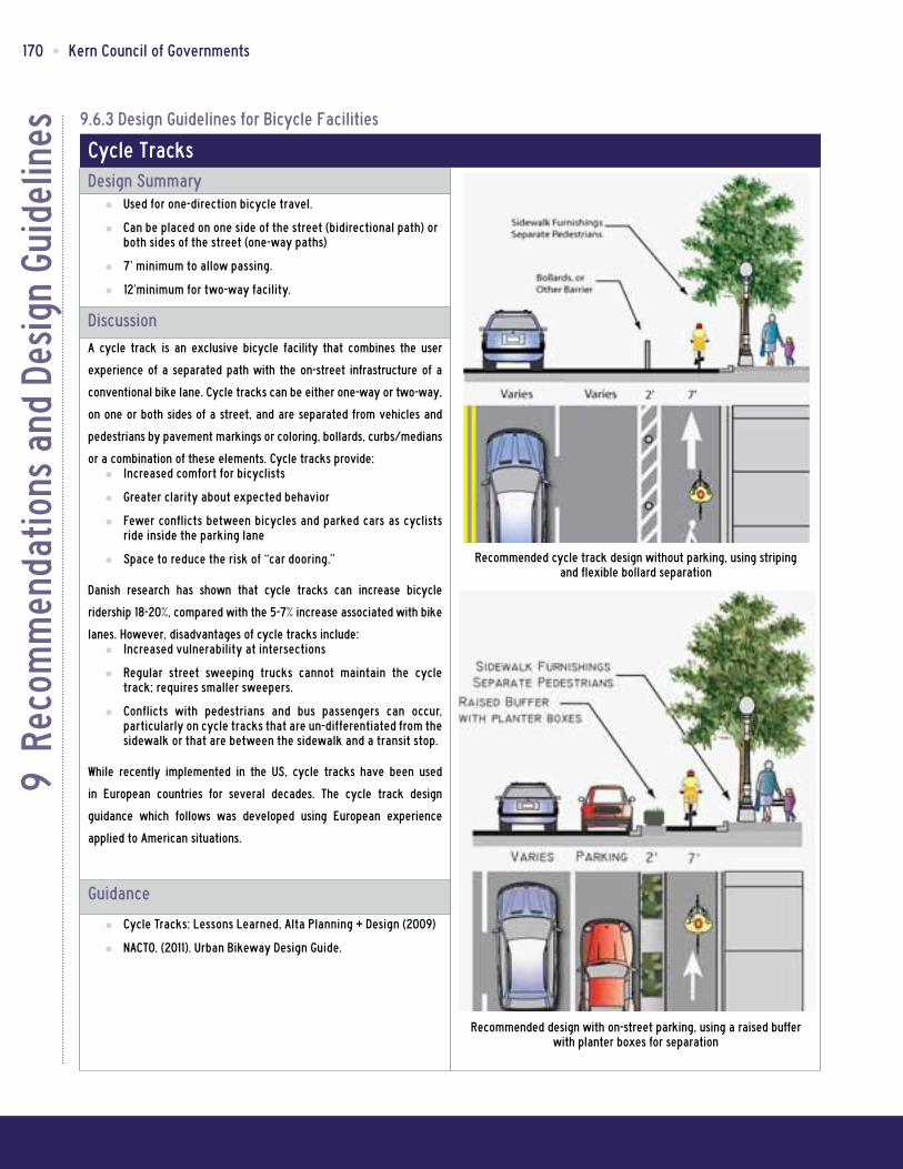
9 R
ecom
men
datio
ns a
nd D
esig
n Gu
idel
ines
170 • Kern Council of Governments
9.6.3 Design Guidelines for Bicycle Facilities
Cycle TracksDesign Summary
Ū Used for one-direction bicycle travel.
Ū Can be placed on one side of the street (bidirectional path) or both sides of the street (one-way paths)
Ū 7’ minimum to allow passing.
Ū 12’minimum for two-way facility.
DiscussionA cycle track is an exclusive bicycle facility that combines the user
experience of a separated path with the on-street infrastructure of a
conventional bike lane. Cycle tracks can be either one-way or two-way,
on one or both sides of a street, and are separated from vehicles and
pedestrians by pavement markings or coloring, bollards, curbs/medians
or a combination of these elements. Cycle tracks provide: Ū Increased comfort for bicyclists
Ū Greater clarity about expected behavior
Ū Fewer conflicts between bicycles and parked cars as cyclists ride inside the parking lane
Ū Space to reduce the risk of “car dooring.”
Danish research has shown that cycle tracks can increase bicycle
ridership 18-20%, compared with the 5-7% increase associated with bike
lanes. However, disadvantages of cycle tracks include: Ū Increased vulnerability at intersections
Ū Regular street sweeping trucks cannot maintain the cycle track; requires smaller sweepers.
Ū Conflicts with pedestrians and bus passengers can occur, particularly on cycle tracks that are un-differentiated from the sidewalk or that are between the sidewalk and a transit stop.
While recently implemented in the US, cycle tracks have been used
in European countries for several decades. The cycle track design
guidance which follows was developed using European experience
applied to American situations.
Guidance
Ū Cycle Tracks: Lessons Learned, Alta Planning + Design (2009)
Ū NACTO. (2011). Urban Bikeway Design Guide.
Recommended cycle track design without parking, using striping and flexible bollard separation
Recommended design with on-street parking, using a raised buffer with planter boxes for separation

9 Recomm
endations and Design GuidelinesComplete Streets Recommendations • 171
Intersection Crossing MarkingsDesign SummaryBicycle pavement markings through intersections indicate the intended
path of bicyclists through an intersection or across a driveway or ramp.
They guide bicyclists on a safe and direct path through the intersection
and provide a clear boundary between the paths of through bicyclists
and either through or crossing motor vehicles in the adjacent lane.
Discussion Ū See MUTCD Section 3B.08: “dotted line extensions”
Ū Crossing striping shall be at least six inches wide when adjacent to motor vehicle travel lanes. Dotted lines should be two-foot lines spaced two to six feet apart.
Ū Chevrons, shared lane markings, or colored bike lanes in conflict areas may be used to increase visibility within conflict areas or across entire intersections. Elephant’s Feet markings are common in Europe and Canada.
Additional markings such as chevrons, shared lane markings, or
colored bike lanes in conflict areas are strategies currently in use in
the United States and Canada. Cities considering the implementation
of markings through intersections should standardize future designs to
avoid confusion.
Because the effectiveness of marked crossings depends entirely on
their visibility, maintaining marked crossings should be a high priority.
Guidance
Ū FHWA. (2009). Manual on Uniform Traffic Control Devices. (3A.06)
Ū NACTO. (2011). Urban Bikeway Design Guide.
Crossing marking treatments from left to right: chevrons, shared lane markings, colored conflict areas, and elephant’s feet
Example of dotted line extensions

9 R
ecom
men
datio
ns a
nd D
esig
n Gu
idel
ines
172 • Kern Council of Governments
Bike BoxesDesign Summary
Ū Bike box dimensions: 14’ deep to allow for bicycle positioning.
Ū Use appropriate signs as recommended by the MUTCD. Signs should prohibit ‘right turn on red’ and indicate where the motorist must stop.
DiscussionA bike box is generally a right angle extension of a bike lane at the
head of a signalized intersection. The bike box allows bicyclists to
move to the front of the traffic queue on a red light and proceed first
when that signal turns green. Motor vehicles must stop behind the
white stop line at the rear of the bike box.
Bike boxes can be combined with dashed lines through the intersection
for green light situations to remind right-turning motorists to be
aware of bicyclists traveling straight, similar to a colored bike lane
treatment. Bike boxes can be installed with striping only or with
colored treatments to increase visibility. Use of coloration substantially
increases costs of maintenance over uncolored (striping, bicycle
symbol, and text only) treatments.
Bike boxes should be located at signalized intersections only, and
right turns on red should be prohibited. Bike boxes should be used at
locations that have a large volume of cyclists, and are often utilized
in central areas where traffic is usually moving slowly. Reducing right
turns on red improves safety for cyclists and does not significantly
impede motor vehicle travel.
On roadways with one travel lane in each direction, the bike box also
facilitates left turning movements for cyclists.
Guidance
Ū Evaluation of Innovative Bike Box Application in Eugene, Oregon, Author: Hunter, W.W., 2000
Ū NACTO. (2011). Urban Bikeway Design Guide. Recommended design of a bike box

9 Recomm
endations and Design GuidelinesComplete Streets Recommendations • 173
Bike SignalsDesign SummaryBicycle signals are authorized in California under the California
Vehicle Code Sections 21450, 21456.2 and 21456.3. Bicycle signals
have commonly been actuated by a pedestrian push-button with
supplementary signage plate. However, since 2007 AB-1581 mandated
that Caltrans develop enhanced loop detectors. Caltrans conducted
numerous studies which resulted in a preferred loop detector Type
“D” as shown in Caltrans Standard Plan ES-5B. An additional “bike”
pavement logo may also be placed over the loop detector to help
bicyclists and motorcyclists properly position themselves over the
detectors. Bicycle signals are used for bicycle-only movements or at
bicycle path crossings of roadways. In California, minimum bicycle
timing is set on a 14.7 ft/sec travel speed (10 mph).
DiscussionSpecific locations where bicycle signals have had a demonstrated
positive effect include:
Ū Those with high volume of bicyclists at peak hours
Ū Those with high numbers of bicycle/motor vehicle crashes, especially those caused by turning vehicle movements
Ū At T-intersections with major bicycle movement along the top of the “T.”
Ū At the confluence of an off-street bike path and a roadway intersection
Ū Where separated bike paths run parallel to arterial streets
Local municipal code should be checked or modified to clarify that
at intersections with bicycle signals, bicyclists should only obey the
bicycle signal heads. For improved visibility, smaller (4 inch lens)
near-sided bicycle signals should be considered to supplement far-side
signals.
Guidance
Ū CA-MUTCD Section 4C Bicycle Signal Warrant; Section 4D Bicycle Signals; Figure 4D-112(CA); Section 9B.13 Bicycle Signal Actuation Sign (R10-22); Section 9D.02 Signal Operations for Bicycles
1/2 size near-side bicycle signal for greater visibility
Visual variation in signal head housing may increase awareness
Bicycle signals must utilize appropriate detection and actuation
Signage may clarify proper usage
Bicycle signal guidance
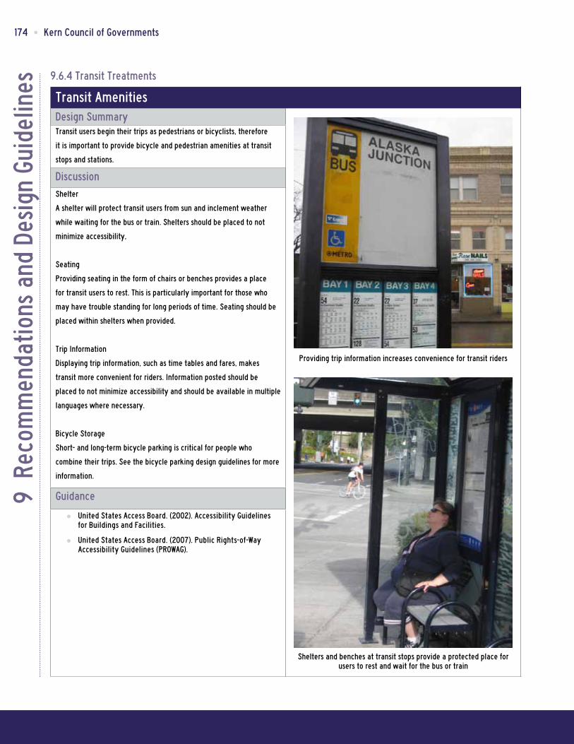
9 R
ecom
men
datio
ns a
nd D
esig
n Gu
idel
ines
174 • Kern Council of Governments
9.6.4 Transit Treatments
Transit AmenitiesDesign SummaryTransit users begin their trips as pedestrians or bicyclists, therefore
it is important to provide bicycle and pedestrian amenities at transit
stops and stations.
DiscussionShelter
A shelter will protect transit users from sun and inclement weather
while waiting for the bus or train. Shelters should be placed to not
minimize accessibility,
Seating
Providing seating in the form of chairs or benches provides a place
for transit users to rest. This is particularly important for those who
may have trouble standing for long periods of time. Seating should be
placed within shelters when provided.
Trip Information
Displaying trip information, such as time tables and fares, makes
transit more convenient for riders. Information posted should be
placed to not minimize accessibility and should be available in multiple
languages where necessary.
Bicycle Storage
Short- and long-term bicycle parking is critical for people who
combine their trips. See the bicycle parking design guidelines for more
information.
Guidance
Ū United States Access Board. (2002). Accessibility Guidelines for Buildings and Facilities.
Ū United States Access Board. (2007). Public Rights-of-Way Accessibility Guidelines (PROWAG).
Providing trip information increases convenience for transit riders
Shelters and benches at transit stops provide a protected place for users to rest and wait for the bus or train

9 Recomm
endations and Design GuidelinesComplete Streets Recommendations • 175
9.6.5 Roadway Treatments
Advance Stop Bar / Yield LineDesign SummarySeparating pedestrians and motor vehicles at intersections improves
safety and visibility.
DiscussionAdvance stop bars and yield lines increase pedestrian comfort and
safety by stopping motor vehicles well in advance of marked crosswalks,
allowing drivers a better line of sight of pedestrians.
They give drivers in the traffic inner lane time to yield to
pedestrians, minimizing the risk of a multiple threat crash. Without
an advance yield bar, the driver in the outer lane may yield
to the pedestrian, but the vehicle in the inner lane proceeds,
increasing the possibility of a vehicle-pedestrian conflict.
Pedestrians may also feel more comfortable since motor vehicles are
not stopped adjacent to the crosswalk.
Advanced stop bars should be used: Ū On streets with at least two travel lanes in each direction.
Ū Prior to a marked crosswalk
Ū In one or both directions of motor vehicle travel
Ū Recommended 30-feet in advance of the crosswalk.
Ū A “Yield Here for Pedestrians” sign must accompany the advance yield line.
Guidance
Ū United States Access Board. (2007). Public Rights-of-Way Accessibility Guidelines (PROWAG). Advance stop bars and yield lines alert motorists of pedestrians
and provide increased visibility for persons crossing the street
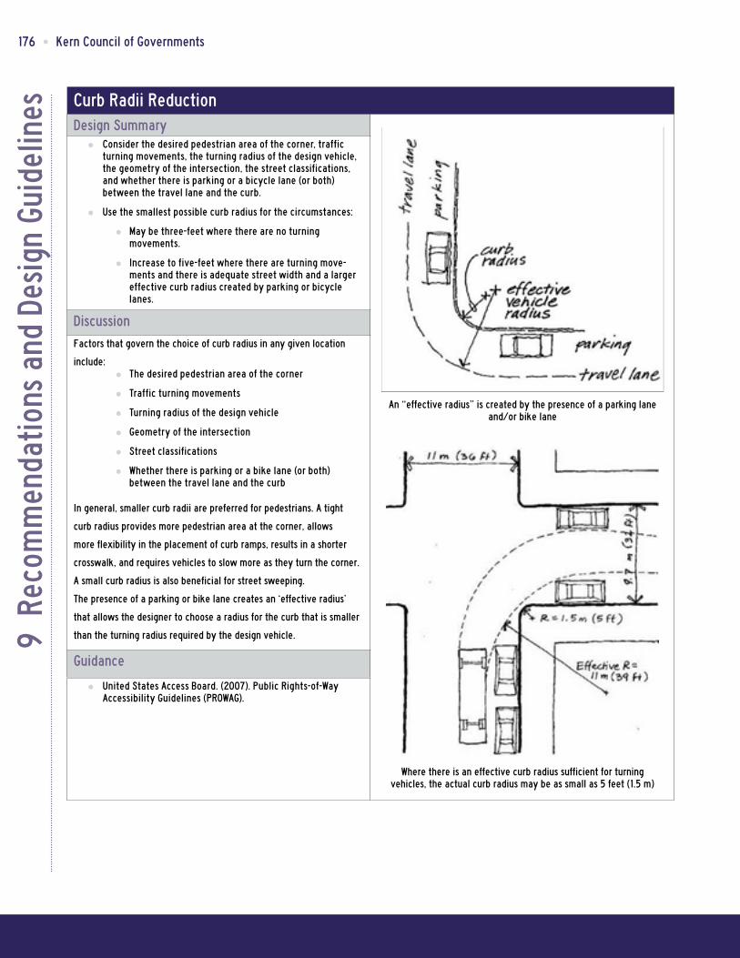
9 R
ecom
men
datio
ns a
nd D
esig
n Gu
idel
ines
176 • Kern Council of Governments
Curb Radii ReductionDesign Summary
Ū Consider the desired pedestrian area of the corner, traffic turning movements, the turning radius of the design vehicle, the geometry of the intersection, the street classifications, and whether there is parking or a bicycle lane (or both) between the travel lane and the curb.
Ū Use the smallest possible curb radius for the circumstances:
Ū May be three-feet where there are no turning movements.
Ū Increase to five-feet where there are turning move-ments and there is adequate street width and a larger effective curb radius created by parking or bicycle lanes.
DiscussionFactors that govern the choice of curb radius in any given location
include: Ū The desired pedestrian area of the corner
Ū Traffic turning movements
Ū Turning radius of the design vehicle
Ū Geometry of the intersection
Ū Street classifications
Ū Whether there is parking or a bike lane (or both) between the travel lane and the curb
In general, smaller curb radii are preferred for pedestrians. A tight
curb radius provides more pedestrian area at the corner, allows
more flexibility in the placement of curb ramps, results in a shorter
crosswalk, and requires vehicles to slow more as they turn the corner.
A small curb radius is also beneficial for street sweeping.
The presence of a parking or bike lane creates an ‘effective radius’
that allows the designer to choose a radius for the curb that is smaller
than the turning radius required by the design vehicle.
Guidance
Ū United States Access Board. (2007). Public Rights-of-Way Accessibility Guidelines (PROWAG).
An “effective radius” is created by the presence of a parking lane and/or bike lane
Where there is an effective curb radius sufficient for turning vehicles, the actual curb radius may be as small as 5 feet (1.5 m)

9 Recomm
endations and Design GuidelinesComplete Streets Recommendations • 177
Traffic Calming FeaturesDesign Summary
Ū To reduce the speed of motor vehicles traveling on a roadway in order to enhance the safety and comfort of pedestrians and bicyclists
DiscussionSpeed Humps / Speed Tables
Speed humps and speed tables reduce speeds by causing motorists
to slow when approaching. Slopes should be between 1:10 and 1:25.
Tapers should be no greater than 1:6 to reduce the risk of bicyclists
losing their balance. The vertical lip should be no more than a 1/4”
high.171
Chicanes/Chokers
Chicanes and chokers shift the driver’s paths, which result in reduced
speeds. Where possible, provide a bicycle route outside of the element
so bicyclists have a direct path away from the pinch point.
Speed Feedback Signs
Speed feedback signs display the driver’s speed on a digital display.
The signs will flash when a driver is over the posted speed limit and
will show a blank screen otherwise.
Neighborhood Traffic Circles or Roundabouts
These intersection designs require drivers and bicyclists to yield and
merge around a circular island. This increases awareness of road users
and decreases speeds. Circles, which have stop control or no control,
have generally been replaced by roundabouts, which require entering
vehicles to yield to circulating vehicles.
Traffic calming can deter motorists from driving on a street. Anticipate
and monitor vehicle volumes on adjacent streets to determine whether
traffic calming results in inappropriate volumes. Traffic calming can be
implemented on a trial basis.
Guidance
Ū BikeSafe. (No Date). Bicycle countermeasure selection system.
Ū Ewing, Reid. (1999). Traffic Calming: State of the Practice.
Ū Ewing, Reid and Brown, Steven. (2009). U.S. Traffic Calming Manual.
Ū NCHRP. (2010) Roundabouts: An Informational Guide
Speed humps
Traffic circle
Chicane

9 R
ecom
men
datio
ns a
nd D
esig
n Gu
idel
ines
178 • Kern Council of Governments
On-Street ParkingDesign Summary
Ū Improve the safety of bicyclists traveling adjacent to on-street parking by increasing visibility
DiscussionBack-In Angle Parking and Parallel Parking
In areas with high parking demand such as urban commercial areas,
diagonal parking can be used to increase parking supply. Conventional
“head-in” diagonal parking is not recommended in conjunction with
high levels of bicycle traffic or with the provision of bike lanes as
drivers backing out of conventional diagonal parking spaces have poor
visibility of approaching bicyclists.
Back-in angle parking benefits include: improved sight distance
between drivers and bicyclists, cargo access occurs at the curb rather
than in the street, passengers (including children) are directed by
open doors towards the curb, and no door conflict with bicyclists. While
there may be a learning curve for some drivers, using back-in diagonal
parking is typically an easier maneuver than conventional parallel
parking. Spaces should be at least 9’6” wide and explanatory signage
may be needed initially. Parallel parking is also preferred as it can
provide sufficient space for adjacent bikeway facilities.
Parking Control
Parking restrictions improve visibility in the vicinity of the crosswalk.
Prohibit parking within all intersections and crosswalks unless
otherwise signed. At “T” and offset intersections, where the boundaries
of the intersection may not be obvious, this prohibition should be
emphasized with signage.
Guidance
Ū Currently slated for inclusion in the upcoming AASHTO Guide for the Development of Bicycle Facilities.
Ū Nelson Nygaard Consulting Associates. (2005). Back-in/Head-out Angle Parking.
Recommended design of bike lanes next to back-in diagonal parking
Back-in diagonal parking provides increased safety for bicyclists as compared to head-in diagonal parking due to drivers’ improved
visibility as they exit the parking spot

9 Recomm
endations and Design GuidelinesComplete Streets Recommendations • 179
Roadway WideningDesign Summary
Although opportunities to add bike lanes through roadway widening
may exist in some locations, other major streets in Kern County pose
physical and other constraints requiring street retrofit measures within
existing curb-to-curb widths. As a result, many of the recommended
measures effectively reallocate existing street width through striping
modifications to accommodate dedicated bike lanes.
DiscussionBike lanes could be accommodated on many streets with excess right-
of-way through shoulder widening. Although street widening incurs
higher expenses compared with re-striping projects, bike lanes could
be added to streets currently lacking curbs, gutters and sidewalks
without the high costs of major infrastructure reconstruction.
As a long-term measure, Kern County should find opportunities to add
bike lanes to other major streets where they are needed. Opportunities
include adding bike lanes as streets and bridges are widened for
additional auto capacity or as property development necessitates
street reconstruction.
Guidance
Example of roadway widening to accommodate bike lanes
Roadway widening is preferred on streets lacking curbs, gutter, and sidewalks

180 • Kern Council of Governments
This page intentionally left blank.