Embed Size (px)
Citation preview
KrzysztofSośnica,GrzegorzBury,RadosławZajdel,KamilKaźmierski,MateuszDrożdżewski,TomaszHadaś
Combinedmulti-GNSS+LAGEOSsolutionswiththefocusonSLRstationcoordinates,Earthrotationparameters,
geocenterandthescaleofthereferenceframe
Institute ofGeodesy andGeoinformatics,WUELS,Poland
ILRS2017TechnicalWorkshop“Improving ILRS Performance to Meet Future GGOS Requirements”Riga,Latvia,2017

Motivation
• Currently,theSLRreferenceframeisbasedon2LAGEOSand2Etalon satellites.ThecontributionofEtalonisalmostnegligible.
• All new GNSSsystems are equipped withlaserretroreflector arrays.• Noactivesatellites,suchasGNSS,areusedfortheITRFdefinition,e.g.,fortheestimation ofGNSSstation
coordinates,geocenter coordinates or Earthrotation parameters.• Some stations,e.g.,fromtheRussianSLRnetwork,provide muchmore SLRobservations toGNSSthan to
LAGEOS.• Between 2014and2017,ILRSconducted aseries ofintesive campaings tracking GNSS.• Today,there are about 60active GNSSsatellites tracked byILRSstations.
LAGEOS-1/2
Standard SLR solution
This study
LAGEOS-1/2
1 GPS
31 GLONASS
18 Galileo
4 BeiDou
1 QZSS

Stationcoordinates - core stations
Matera(Italy):
RMS:9.07.96.7mmforNorth,East,Up,resp.inLAGEOS-1/2RMS:5.1 4.85.6 mmforNorth,East,Up,resp.inLAGEOS+GNSSfix143solutions inLAGEOS-1/2144solutions inLAGEOS+GNSS
Herstmonceux (UK):
RMS:4.03.83.6 mmforNorth,East,Up,resp.inLAGEOS-1/2RMS:3.93.7 3.4mmforNorth,East,Up,resp.inLAGEOS+GNSSfix170solutions inLAGEOS-1/2170solutions inLAGEOS+GNSS
->Minorimprovement forhigh-performingSLRstations

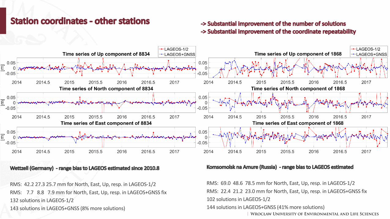
Stationcoordinates - other stations
Altay (Russia):
RMS:31.1 19.8 24.3 mmforNorth,East,Up,resp.inLAGEOS-1/2RMS:17.1 16.5 16.6 mmforNorth,East,Up,resp.inLAGEOS+GNSSfix132solutions inLAGEOS-1/2161solutions inLAGEOS+GNSS(23%more solutions)
Brasilia(Brazil):
RMS:11.6 11.5 11.2mmforNorth,East,Up,resp.inLAGEOS-1/2RMS:15.1 16.8 14.3 mmforNorth,East,Up,resp.inLAGEOS+GNSSfix79solutions inLAGEOS-1/2103solutions inLAGEOS+GNSS(30%more solutions)
Stationcoordinates - other stations
Wettzell (Germany)- range bias toLAGEOSestimated since 2010.8
RMS:42.227.325.7 mmforNorth,East,Up,resp.inLAGEOS-1/2RMS:7.7 8.8 7.9 mmforNorth,East,Up,resp.inLAGEOS+GNSSfix132solutions inLAGEOS-1/2143solutions inLAGEOS+GNSS(8%more solutions)
KomsomolsknaAmure (Russia)- range bias toLAGEOSestimated
RMS:69.0 48.6 78.5 mmforNorth,East,Up,resp.inLAGEOS-1/2RMS:22.4 21.2 23.0 mmforNorth,East,Up,resp.inLAGEOS+GNSSfix102solutions inLAGEOS-1/2144solutions inLAGEOS+GNSS(41%more solutions)
->Substantialimprovementofthenumberofsolutions->Substantialimprovementofthecoordinaterepeatability

Earthrotation parameters w.r.t.IERS-C04-14
Xpole[μas] Ypole[μas] LOD[μs]Solution mean RMS mean RMS mean RMSLAGEOS-only 77.8 157.2 52.9 143.2 -81.6 122.5LAGEOS+GNSS(GNSSorbitsfreelyestimated)
81.8 153.6 55.1 142.7 25.5 68.7
LAGEOS+GNSS(orbitsfixedtomicrowaveGNSS)
73.5 149.0 51.3 140.7 0.5 43.0
Draconitic yearofLAGEOS-2
SLR observations to GNSS allow for the transfer of the network orientationfrom GNSS to SLR solutions.
No significant improvementfor the X and Y pole coordinates, becausein both solutions the no-net-rotation constraint isimposed on the same setof core SLR stations, whosestation coordinates improveonly slightly in LAG+GNSS.Pole: 150 μas = 5 mmLoD: 40 μs = 20 mm.
Such high-quality LoD from SLR could not be earlierobtained without estimatinggravity field, especially C20.

Back-upslides

Number ofsolutions fordifferent SLRstations
Theoccurence ofSLRstations in7-daysolutions fortheperiod2014.0-2017.5in%.
• Number ofstations in7-daysolutions is:3909(LAGEOS-only),3476(GNSS-only),4170(LAGEOS+GNSS).• Some stations (Haleakala,Hawaii,7119,Arequipa,Peru,7403)donotobserve GNSSsatellites.However,mostoftheSLRstations observe GNSSontheregular
basis (7090,7840,7237,7825,7105,7941,8834).• Some stations provide byfarmore observations toGNSSthan toLAGEOS(Altay,Russia,1879,Shanghai,China,7821,Komsomolsk,Russia1868,Arkhyz,Russia,
1886,Brasilia,Brazil,7407,Beijing,China,7249,Mendeleevo,Russia,1874,Wettzell,Germany,7827).

Stationcoordinate repeatability
Mean improvement ofLAGEOS+GNSSfix wrt LAGEOS-1/2:6.9,6.4,15.7%,forN,E,U,resp.

Stationcoordinates- other stations
Zelenchuksakya (Russia):
RMS:49.6 56.3 27.9 mmforNorth,East,Up,resp.inLAGEOS-1/2RMS:21.6 18.4 15.4 mmforNorth,East,Up,resp.inLAGEOS+GNSSfix108solutions inLAGEOS-1/2123solutions inLAGEOS+GNSS(14%more solutions)
Arkhyz (Russia):
RMS:77.2 30.2 94.7 mmforNorth,East,Up,resp.inLAGEOS-1/2RMS:28.0 22.3 19.9 mmforNorth,East,Up,resp.inLAGEOS+GNSSfix100solutions inLAGEOS-1/2139solutions inLAGEOS+GNSS(39%more solutions)

Scale ofthereference frame w.r.t.ITRF2014(SLRF2014)
Draconitic yearofLAGEOS-2
LAGEOS-2orbitalaliaswithP1 tide
Drift ofLAGEOS-2perigee wrtecliptical longitude
Secondharmonicofthedrift ofLAGEOS-1perigee wrt ecliptical
longitude
Scale difference w.r.t.ITRF2014:
6.05± 3.14mmforLAGEOS-1/25.73± 3.22mmforLAGEOS+GNSSest5.16± 2.71mmforLAGEOS+GNSSfixFixingGNSSorbitsalignsbetterthescaletoITRF2008,becauseGNSSsolutionsarenotaffectedbytheblue-skyeffect(inthissolutionatmosphericpressureloadingcorrections are notapplied)
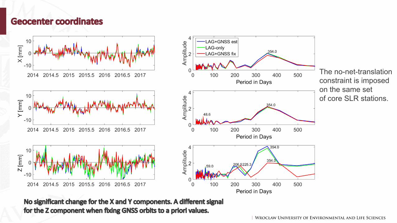
Geocenter coordinates
Nosignificant change fortheXandYcomponents.Adifferent signalfortheZcomponentwhen fixing GNSSorbits toapriorivalues.
The no-net-translationconstraint is imposedon the same setof core SLR stations.

LAGEOSorbits
SLR observations to GNSS satellites can also indirectlyimprove the LAGEOS orbitsthanks to providing a betterorientation of the network.As a result, especially the orientation parameters, inclination, node, perigee, areimproved in the LAGEOS+GNSS solutions.