Embed Size (px)
Citation preview

Combating Land Degradation by Minimal Intervention:The Connectivity Reduction Approach
Sixth Framework Programme
Written and Edited by the RECONDES Project Team

COMBATING LAND DEGRADATION BY MINIMAL INTERVENTION: THE CONNECTIVITY REDUCTION APPROACH 1
Introduction and context
Desertifi cation and its related problems of soil erosion and land degradation are identifi ed by the European Union as becoming one of their largest environmental problems as a result of global change.
Soil erosion and land degradation have negative ‘on-site’ and ‘off-site’ effects: on the fi elds the topsoil is being removed by water fl owing over the soil surface. These ‘on-site’ processes lead to a decrease in soil quality as most nutrients are present in the topsoil. So erosion leads to impoverishment of the soil, but it also deteriorates the water absorbing properties of the soil, reducing infi ltration of water into the soil. Therefore, eroded soils often give higher amounts of runoff than non-degraded soils.
The soil material, including the nutrients it contains, as well as the increased amounts of water, are transported downwards through the catchment, where the soil may be deposited in reservoirs, eventually silting them up. In the case of fl ooding, the sediment may also be deposited in urban areas causing direct damage to buildings and roads and even to humans. These ‘off-site’ effects are a second negative effect of land degradation in upland areas.
The aim of these guidelines is to present novel and effective sustainable measures to reduce the on-site problems of land degradation in two ways:• identifi cation of ‘hotspots’ in the landscape where runoff occurs, increasing soil
degradation.• application of environmentally sound and effective revegetation strategies on the
identifi ed hotspots using suitable plant species.
This approach is different from other approaches in that it identifi es hotspots and focuses on the application of appropriate vegetation species to these areas, whereas in other approaches measures are applied across the entire landscape.
Vegetation has several positive effects: its roots reduce erosion by holding the soil together, the stems and leaves obstruct water fl ow so lowering fl ow velocities and the ability to carry sediments, and furthermore infi ltration of water into the soil is enhanced under the vegetation. The placement of vegetation in hotspots should be adjusted in such a way that these positive effects are maximized. Also, the most suitable vegetation species should be selected, which are adapted to the environment where they are being applied, and that also have the largest effects with regard to their rooting system and their above-ground canopy and stem structure. The resistance and resilience of the vegetation to fl ow conditions is also considered as the vegetation application should be a sustainable strategy to reduce on-site degradation problems. In this way, not only ‘on-site’ degradation is being reduced, but also ‘off-site’ problems are being reduced. Furthermore, this remediation strategy is a ‘green’ and environmentally sound solution to degradation problems in dryland regions.

2 COMBATING LAND DEGRADATION BY MINIMAL INTERVENTION: THE CONNECTIVITY REDUCTION APPROACH
Processes of land degradation
Land degradation is a reduction or loss of the biological productivity and complexity resulting from land uses or from natural and human driven processes such as soil erosion caused by wind and/or water; deterioration of soil properties; and loss of natural vegetation. When land degradation occurs in arid to dry sub-humid areas then it is called desertifi cation. More specifi cally, land degradation includes soil erosion, soil acidifi cation/salinization, fertility depletion, soil crusting, compaction, reduction in soil organic carbon, in biomass and loss of biodiversity. Here, we will examine some of the aspects related to processes of runoff generation, sediment production and export and the role of vegetation in counteracting these processes.
Runoff generation and soil erosionIn arid to dry sub-humid areas overland fl ow normally occurs when rainfall intensity exceeds the rate at which water infi ltrates into the soil. This process can be promoted by the destruction of soil aggregates (if present) and the packing of soil particles (sealing and crusting). One of the main factors in causing this decrease in infi ltration rate is raindrop impact on bare soils with low vegetation cover. When rain exceeds infi ltration, water begins to move following local slope gradient. During this phase soil splashed by raindrops is entrained by the fl ow and removed from the spot, so that mineral particles and organic matter are exported. Once concentrated, runoff moves faster and can erode the soil, incising the landscape. Now the level of damages is increased. Mineral particles and organic matter are exported in larger quantities, while the incision further facilitates concentrated fl ow to erode and transport more sediment. In this way rills and gullies can form.
When thunderstorms occur, even if they are rare, they can produce a large amount of water in a short time span across local areas. This excess of water, assisted by a network of small rills, gullies, and channels, can produce fl ooding. Of course, this occurs in all climates, but the problems are more severe in dryland areas where soil is often bare and more exposed to erosion. Moreover, dryland areas require more time to recover from the shock of intense rainfalls because all the processes of soil formation and of vegetation re-establishment in severely eroded sites are slower than in more humid environments, counteracted as they are by scarcity of water and recurrent droughts.
It is evident that vegetation plays an important role in opposing these processes of erosion and land degradation. Plants locally protect the soil surface from the impact of rain drops, their canopy reducing or completely wiping out their destructive and erosive power (no aggregate destruction, no raindrop splashed soil lost to overland fl ow). Moreover plants protect the soil from direct solar radiation. This is benefi cial for the local ecosystem which can host more biological activity which means in the long run, more active soil forming processes, particularly the formation of new stable soil aggregates. The roots, with both their physical action and positive infl uence on soil mineral and nutrient levels, further improve soil resistance to erosion. All this also promotes porosity and macro-porosity with strong benefi cial effects on infi ltration rate (and water availability to plants on the site). Finally, plants locally increase hydraulic resistance to water movement causing sediment deposition and decreasing the erosivity of runoff.

COMBATING LAND DEGRADATION BY MINIMAL INTERVENTION: THE CONNECTIVITY REDUCTION APPROACH 3
HotspotsHotspots are places that, unless properly managed, can be severely eroded (or receive excessive sedimentation) and begin a process of export of unwanted sediment. Examples are river and gully banks where river processes, wall collapse and runoff from upslope areas can trigger the creation of a new headcut that will then retreat upslope and/or sidewise to the main water course (Figure 1).
As another example, semi-arid agricultural terraces with a counter slope at the end of their sub-horizontal surfaces work as collector of runoff from large areas. If not properly managed, water can spill over the counter-slope (or undercut the system by tunnelling), concentrating large amounts of runoff and increasing connectivity (Figure 2).
Generally hotspots can be managed locally by, for example, protecting them with vegetation. This can decrease the amount of water that will be transmitted downslope and even stop sediment transport. Other protection measures can be based on reducing the amount of runoff and sediment from upslope, for example intercepting runoff and sediment in several places where local fl ux concentration can still be managed effectively and possibly at a lower cost. Most of the sediment is lost from these hotspots in the landscape. Therefore, if they can be identifi ed they can be targeted for action.
Figure 2 Example of hotspot: Spill over of water at terrace counter-slope, leading to export of sediments.
Figure 1 Example of hotspot: Gully headcut retreating upslope into fi eld.

4 COMBATING LAND DEGRADATION BY MINIMAL INTERVENTION: THE CONNECTIVITY REDUCTION APPROACH
Principles of approach and methods
SustainabilityAny techniques of land, water or soil management that are applied need to be sustainable. This means that they can be maintained and continued over a long time without causing detrimental consequences, without decreasing quality of life or environment, and without causing markedly increased costs that would not otherwise be incurred. Ideally, they should be self-maintaining. They should allow the use of the land in a way that suits the conditions and landuse. The methods may need to allow for adaptation as conditions change, for example due to global warming.
ConnectivityThis is a term which means the extent to which parts of the landscape are connected, or the extent to which there are pathways which can be identifi ed in the landscape. These pathways or connections are primarily the fl ow of water and the movement of sediment. Water will naturally fl ow down slope and down through channels and it will transport sediment with it if it can pick up sediment (erosion) and has suffi cient energy to carry it. Pathways of water will continue until the water runs out or it reaches an end point of the catchment. Sediment will be carried until the water runs out or until all the sediment is deposited due to the setting. These endpoints represent ends of pathways. If this is part way down a slope or down a channel then this means the pathways are not continuous throughout the drainage basin (catchment). The longer these pathways, the further away water and sediment will be removed from the slopes, causing a decrease in fertility of the soil, and causing problems downstream.
The main aim of the conservation practices recommended here is to minimise connectivity, particularly of sediment, so reducing soil loss. Many modern land use practices have tended to increase the connectivity, causing increased soil erosion problems. The idea here is to use vegetation in these pathways to reduce the connectivity.
Vegetation effectsThe main idea is to identify the locations and conditions where vegetation could be increased or could be encouraged to grow. Suitable types of plants also need to be identifi ed. Vegetation is used because it can prevent erosion or soil loss by increasing the resistance of the soil to removal. Again, many of the problems are due to a lack of vegetation cover or a decrease from former conditions. The presence of vegetation can also encourage infi ltration of water into soil, keeping the water on the slope. Once vegetation is established it can help to create better conditions for further growth by adding organic matter. This also increases the stability of the soil to erosion.
Strategic placement of vegetationThe idea of the use of vegetation to manage soil erosion as part of conservation management is not new. What is new here is the idea of placing the vegetation in particular locations. These are the locations where it will have maximum effect. They are in the pathways of fl ow of water and sediment. The methods involve identifying where in the landscape it would be most benefi cial to establish vegetation. This will be cheaper to establish than trying to plant everywhere, as has been done in many reforestation schemes. It also means the rest of the land can still be used.
Scales of applicationThese planting strategies can be applied at a variety of scales, as is shown in the next section. They can be applied at the scale of a fi eld or part of a terraced slope, or in an area of existing reforestation. They can be assessed also at the scale of the whole hillslope. The link between the hillslope and the channel is an important point of potential control. Strategies may also be applied within channels, though mostly small channels.

COMBATING LAND DEGRADATION BY MINIMAL INTERVENTION: THE CONNECTIVITY REDUCTION APPROACH 5
Types of environmentThese approaches and techniques are deigned for application in areas which are prone to soil erosion and in which vegetation tends to be sparse but can grow. Obviously, vegetation can be made to grow where there is an adequate supply of water and other resources and environmental conditions are not limiting. The approach should be sustainable so that the vegetation will grow under natural rainfall and water supply conditions of the location. The initial designs are suited to dryland environments of the Mediterranean region of southern Europe, particularly on soft rock areas such as marl bedrock. These are areas with a long tradition of agriculture and much traditional use of agricultural terraces on steeper slopes. This is the type of landscape which is used in the illustrations. It is based on research in southern Spain.
Steps in approachIn the following pages, further details are given on the problems of erosion arising in different areas of the landscape and vegetation strategies which may be taken to address these problems. Using the information presented in this booklet, the following steps are recommended for developing a revegetation plan:
1. Identify pathways or connectivity within area
2. Identify particular locations or hotspots where erosion tends to occur
3. Assess the conditions for growth of plants in relation to a few factors
4. Identify the types of plants that would grow there
5. Identify additional techniques that are needed to enable plants to grow or establish
6. Implement the techniques
7. Plant seeds or seedlings
Step 1. Identify pathways or connectivity within area
Step 2. Identify particular locations or ‘hotspots’ where
erosion tends to occur
Step 3. Assess the conditions for growth of plants in
relation to a few factors
Step 4. Identify the types of plants that would grow there
Step 5. Identify additional techniques that are needed to
enable plants to grow or establish
Step 6. Implement the techniques
Step 7. Plant seeds or seedlings

6 COMBATING LAND DEGRADATION BY MINIMAL INTERVENTION: THE CONNECTIVITY REDUCTION APPROACH
Reforested land
Problems of soil erosion and land degradation on reforested landExtensive reforestation works have been carried out across Spain and other parts of the Mediterranean using terracing to reduce runoff and improve soil water availability for plants with the objective of controlling soil erosion in degraded areas. As a consequence, large areas have been topographically altered and covered by homogeneous, even-aged coniferous forest (primarily Pinus halepensis). However, reforestation has not always been successful and it is now realised that past methods of construction may contribute to the development of erosional problems. Defective terraces, which are not perpendicular to the slope, act as fast runoff pathways (Figure 3). Local defaults in terraces act as points for fl ow to concentrate, resulting in further erosion. With time, old reforestation terraces collapse, increasing connectivity in these lands (Figure 4).
The construction of terraces and side banks not only dramatically alters the topography of the landscape, but also negatively impacts the establishment of plant cover and plant biodiversity.
A
Figure 3 Terracing can increase hydrological connectivity of reforested lands:(A) Terraces not-perpendicular to slope act as collector and fast runoff paths.(B) Failures of terrace embankments are the origin of headwater gullies.
Figure 4 Torrential runoff events and active headwater erosion processes can destroy terraces and trigger land degradation.
B

COMBATING LAND DEGRADATION BY MINIMAL INTERVENTION: THE CONNECTIVITY REDUCTION APPROACH 7
A medium term survival rate of 50% has been reported in studies of Pinus halepensis reforestations in semiarid Mediterranean environments. While some studies suggest that planted forest may improve soil properties in decades, others have found lower soil organic content and nutrient concentration under Pinus plantations than in adjacent shrublands. Vegetation colonization on the side banks is also very low (Figure 5).
Studies in SE Spain reveal that after 30 years the side bank is hardly colonized, and bare soil is 12 times more frequent than on the terrace. The species pool is also severely depleted, species richness is less than half than in original slopes (Figure 6). The layer of litter which forms under Pinus halepensis also inhibits the germination of seeds and growth of seedlings, hence hampering the development of an understorey layer.
Vegetation strategies to mitigate erosion and reduce connectivityThe following three vegetation strategies are recommended to correct negative impacts and reduce connectivity in Reforested Lands.
1. Vegetation should be planted where the rills originate, where terraces are collapsing or across terraces not perpendicular to slope as these will form zones of runoff during rainfall events.
2. Side banks are much more extensive structures. Massive plantations of vegetation are expensive, and mostly unsuccessful because of the harsh conditions. Encouraging spontaneous or induced colonization should be the focus of the works. Microstructures built with natural barriers like wood, debris and stones should be established on the side banks in order to promote the trapping of water, nutrients and seeds. Conditions could be further improved by local addition of organic amendments (to improve soil infi ltration and nutrient status) and seeding with side-bank adapted species.
3. In mature forests, some manipulation of litter layer and seeding of shrubs and grasses should encourage understorey development. This should be especially targeted at areas between trees that function as contributing headwater areas of rills and gullies.
A B
Figure 5 Example of poor, slow re-colonization process on side bank caused by terracing: (A) Contrasting view of reforested and natural slopes. (B) Detail of planted terrace (Te); side bank (artifi cial talus Tn) and non-altered natural slope (Ta).
Figure 6 Planted forests show a low species diversity. The common hypothesis that planted forest will foster vegetation dynamics fails in dry semi-arid environments.

8 COMBATING LAND DEGRADATION BY MINIMAL INTERVENTION: THE CONNECTIVITY REDUCTION APPROACH
Rainfed croplands
Problems of soil erosion and land degradation on croplandsOverland fl ow removes soil material from the fi eld and causes the collapse of terraces: the sparse vegetation cover fails to protect the soil against intense rainfall. On shallow soils, prolonged erosion may lead to a decrease in soil productivity and yield. Runoff concentrates in the valley bottom, on dirt roads and on access tracks of terraces.
Vegetation strategies to mitigate erosion and reduce connectivityAn effective way to reduce erosion problems is to cover the soil during the rainy season. Depending on the water availability, cover crops can be grown throughout the fi eld, limited to strips perpendicular to the slope or in buffer strips along the fi eld border (Figure 10).
In semi-arid areas, where competition for water with the main crop is crucial, it may be necessary to limit the growth of cover crops to terrace/fi eld access tracks and valley bottoms. The cover crops can be killed by tillage in spring. In the case of chemical weeding, the plant residue is left as mulch, keeping the soil covered as much as possible.
Figure 10 Different types of cover crops can be considered, including (A) weeds, (B) legumes and (C) grass species.
A B C
Figure 7 Erosion in fi eld and export of sediments.
Figure 8 Gully formed in bare fi eld. Figure 9 Erosion along track connecting two fi elds.

COMBATING LAND DEGRADATION BY MINIMAL INTERVENTION: THE CONNECTIVITY REDUCTION APPROACH 9
The selection and application of specifi c vegetation measures should be done at the sub-catchment level, taking into account the local climate, landscape and cropping systems. Figure 11 shows priority areas to be protected during the rainy season. The side bank of earth terraces can be stabilised by natural vegetation. This is a common and quite effective practice in many areas.
Table 1 Major benefi ts of vegetation strategies.
Water availability for cover cropsThe water availability for cover crops in rainfed cropping systems strongly depends on the local climate. Figure 12 shows the effect of climate on the tree canopy cover in olive orchards. The possibilities for cover crops are clearly more restricted in, for example, Southeast Spain (300 mm annual rainfall) than in Central Italy (700 mm annual rainfall).
Vegetation strategies Benefi ts
Cover crops/vegetation strips • Effective protection against soil degradation and loss of soil productivity
• Increased infi ltration of rain water• Improvement of soil structure• The mulch left after chemical weeding prolongs the period of soil
protection and decreases water loss by evaporation
Grassed waterways • Reduced risk of gully formation• Reduction of runoff volume and peak discharge at (sub)catchment
level
Figure 11 Priority areas to be protected during the rainy season: terraced orchards/vineyards when competition for water is high (left), orchards on steep slopes (middle) and sloping cereal fi elds (right).
Figure 12 Effect of climate on tree canopy cover in orchards.

10 COMBATING LAND DEGRADATION BY MINIMAL INTERVENTION: THE CONNECTIVITY REDUCTION APPROACH
Abandoned and semi-natural areas
Problems of soil erosion and land degradation on abandoned and semi-natural areasThe focus of the section is on abandoned lands, since these are more disturbed and are therefore more prone to land degradation. However, also in semi-natural areas land degradation can be a problem, although most erosion is considered to be ‘natural erosion’, which is almost inevitable because of the topographic position or erodible substrate. An example of degraded semi-natural areas is Stipa shrublands on marls (Figure 13). Semi-natural lands may especially be vulnerable to accelerated degradation when rills and gullies encroach from surrounding arable and abandoned fi elds. This expansion should be prevented as much as possible.
Abandoned fi elds in semi-arid areas can be vulnerable to erosion because of the slow vegetation recovery and unfavourable soil properties. The combination of a low vegetation cover and the absence of ploughing lead to the formation of soil crusts (Figure 14), which decreases the infi ltration capacity of the soil. This causes an increase in overland fl ow and may lead to rill and gully erosion when the runoff becomes concentrated. Many fi elds are terraced or have earth dams to retain water and once the fi elds are abandoned these soil and water conservation structures are no longer maintained. This increases the risk of terrace failure due to gully erosion (Figure 15) and piping (Figure 16) and once the terrace structures are broken the connectivity increases, which increases the risk that lower lying terrace walls will also collapse.
Figure 13 Degraded Stipa shrubland. Figure 14 Soil crust on recently abandoned fi eld.
Figure 15 Gully initiation on abandoned fi eld. Figure 16 Piping on abandoned grape fi eld.

COMBATING LAND DEGRADATION BY MINIMAL INTERVENTION: THE CONNECTIVITY REDUCTION APPROACH 11
Vegetation strategies to mitigate erosion and reduce connectivityTwo types of vegetation strategies can be distinguished to mitigate the degradation processes in these lands: (1) increase of vegetation cover on the fi eld, which should decrease the occurrence of concentrated runoff, and (2) planting of vegetation on critical spots with concentrated fl ow. The fi rst strategy also includes the maintenance of soil and water conservation structures until the vegetation on the terraces has suffi ciently recovered, e.g. restoration of terrace walls after heavy rainfall and construction of small dikes around existing gullies (Figure 17).
A vegetation cover of more than 30% already decreases runoff considerably. To obtain a quick establishment of vegetation cover perennial species with a fast growth rate, good vegetation cover and the ability to improve the soil properties should be used. Additional seeding and amendment of organic material can stimulate vegetation recovery.
The second strategy focuses on the prevention of terrace failure and development or expansion of gully and rill erosion by planting vegetation on spots where concentrated fl ow can be expected. The water fl ow pattern can be easily identifi ed in the landscape. The locations where lines of concentrated fl ow coincide with a change in gradient (e.g. terrace wall) are hotspots for erosion (Figure 18). To mitigate concentrated fl ow erosion the root system of the vegetation is very important and especially grass roots appear to be very effective. Some native species that may be planted in these hotspots are grasses like Lygeum spartum, Brachypodium retusum and Stipa tenacissima in combination with deeper rooted shrubs like Anthyllis cytisoides, Atriplex halimus or Salsola genistoides.
Figure 18 Map of abandoned terraced fi elds with fl ow paths and observed terrace failures (red points). These can be mitigated by planting vegetation, e.g. Lygeum spartum (right), in areas with concentrated fl ow just before the terrace wall.
Figure 17 Small dike around deep gully.

12 COMBATING LAND DEGRADATION BY MINIMAL INTERVENTION: THE CONNECTIVITY REDUCTION APPROACH
Hillslopes and gullies
Problems of gully erosionConcentrated fl ow zones are hotspots in the landscape where gullies can develop and where large volumes of sediment can be eroded. Several studies indicate that gully erosion may be responsible for up to 80% of total soil losses due to water erosion, whereas the area affected by gully erosion often only operates on less than 5%. In addition, once developed, gullies increase runoff and sediment connectivity in landscapes, thereby transferring runoff and sediment rapidly from uplands to lowlands. The location of potential gullies is controlled by local topography (i.e. slope gradient and drainage area). Hotspot areas in the landscape where gully erosion is often a problem include existing channels, abandoned croplands and steep badland slopes under semi-natural vegetation.
Vegetation strategies to mitigate erosion and reduce connectivity
On croplandsIn addition to grass stems, which reduce runoff velocity, grass roots increase the topsoil resistance to concentrated fl ow erosion to a large extent and also prevent soil blocks from sliding by increasing the soil cohesion (Figure 20). It is therefore recommended to establish grass buffer strips or grassed waterways where runoff concentrates or at the downslope border of a fi eld.
Figure 19 Illustration of a bank gully (A), which developed in an abandoned terrace and a permanent gully (B) in rangeland on loam soils.
A B
Figure 20 Illustration of Brachypodium retusum roots reinforcing the topsoil and preventing shallow mass movements on the gully wall.
Figure 21 Plan view of fi eld with concentrated fl ow zone and erosion channel (bold line). Double drilling the zone of concentrated fl ow in an ideal situation: i.e. the zone of concentrated fl ow is drilled fi rst, then the entire fi eld.
Downslope direction
COMBATING LAND DEGRADATION BY MINIMAL INTERVENTION: THE CONNECTIVITY REDUCTION APPROACH 13
Double drilling of wheat or cover crops increases the resistance of topsoils to concentrated fl ow erosion (Figure 21). Studies have shown an average reduction in soil loss of 25% for double-drilled compared to single-drilled topsoils.
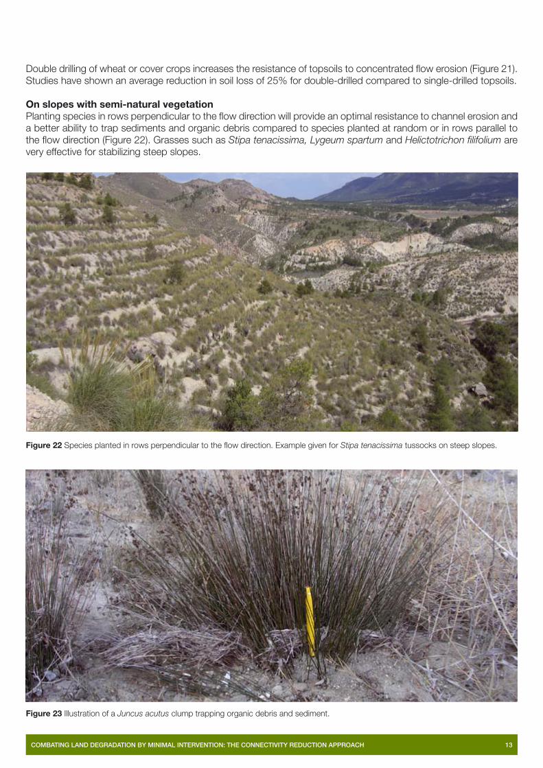
On slopes with semi-natural vegetationPlanting species in rows perpendicular to the fl ow direction will provide an optimal resistance to channel erosion and a better ability to trap sediments and organic debris compared to species planted at random or in rows parallel to the fl ow direction (Figure 22). Grasses such as Stipa tenacissima, Lygeum spartum and Helictotrichon fi lifolium are very effective for stabilizing steep slopes.
• Establish vegetation on gully fl oors. Gullies covered with at least 50% vegetation with high trapping effectiveness (e.g. Juncus acutus, Figure 23) in the gully fl oor as a percentage of total gully fl oor surface become inactive.
• Establish vegetation barriers in gullies to further prevent soil loss. For example, vegetation barrier downslope, covering only 20% of a marly plot, can be suffi cient to trap all the sediments eroded upslope.
Figure 22 Species planted in rows perpendicular to the fl ow direction. Example given for Stipa tenacissima tussocks on steep slopes.
Figure 23 Illustration of a Juncus acutus clump trapping organic debris and sediment.

14 COMBATING LAND DEGRADATION BY MINIMAL INTERVENTION: THE CONNECTIVITY REDUCTION APPROACH
Channels
Problems of soil erosion and land degradation in channelsChannels form major pathways for sediments eroded from agricultural lands by gullies. The erosional activity of gullies and channels are closely linked. As the channel erodes its bed, this erosion migrates upstream, leading to the extension of gully networks and creation of new gullies. Gullies may also form through the channel eroding its banks and adjacent valley walls. Four erosion hotspots are identifi ed in channels: bank gullies, valley walls, tributaries and the channel bed itself (Figure 24). In order to reduce the occurrence of erosion in channels, vegetation strategies need to be effective in decreasing excessive sediment supply from source areas, however also maintain suffi cient balance of runoff and sediment supply so as not to create new erosion areas.
Figure 24 Hotspots of erosion that develop in association with channels.
Vegetation strategies to mitigate erosion and reduce connectivitySome prior understanding of relations in the channel is required in order to assess suitable locations for strategies. The present status of the channel can be assessed by dividing it into a number of reaches, and classifying each reach into one of three zones:
• Erosion zones are characterised as sediment supply areas.
• Transfer zones link erosion and deposition zones; whilst they may also be a source of sediments their major function is to fl ush supplied sediments downstream.
• Deposition zones are areas where sediments are deposited.
Consideration needs to be given to:
• the nature of sediment supply and magnitude of fl ows within each zone, as this will guide plant selection;
• the infl uence increased vegetation may have in reducing fl ow capacity of the channel and decreasing sediment supply to downstream areas (potential to cause a fl ood or erosion problem).
A number of different vegetation strategies may be applied to the identifi ed erosion hotspots. These are outlined in Table 2 with reference to Figure 25.
Eroding banks and valley walls
Eroding channel bed
Incoming gully

COMBATING LAND DEGRADATION BY MINIMAL INTERVENTION: THE CONNECTIVITY REDUCTION APPROACH 15
Table 2 Potential vegetation strategies applied to hotspots.
Hotspot Vegetation strategies
Bank gullies • Reduce fl ows through diversion of runoff from gully. Check condition of terrace banks and repair if necessary. Plant with grasses like Lygeum spartum, Brachypodium retusum and Stipa tenacissima in combination with more deeper rooted shrubs like Anthyllis cytisoides, Atriplex halimus or Salsola genistoides. Increase ground cover in fl ow lines to create grassed waterways and consider planting cover crops in fi elds.
• Encourage deposition of fans and sedimentation before channel. Vegetate fans at base of gully walls. Plant Lygeum spartum.
Valley walls • Encourage deposition of fans and sedimentation at base of valley walls. Vegetate fans and base of valley walls. Plant with Stipa tenacissima, Lygeum spartum and Juncus acutus.
Tributaries • Encourage vegetation at base of channel. Vegetate on raised areas of the bed. Plant Nerium oleander on coarse gravels and Tamarix canariensis on fi ne substrates. Build small log boulder structures to trap sediments and vegetate with Lygeum spartum and Tamarix canariensis.
• Divert fl ow at confl uences. Build small log/boulder structures to trap sediments and vegetate with Lygeum spartum and Tamarix canariensis.
Channel bed
• Encourage more vegetation in areas with sediment. Where there is no sediment deposited, but obvious sources and transfer in zone, encourage deposition by planting vegetation upstream. This may need additional obstructions to cause initial deposition e.g. boulders or logs. Plant Nerium oleander on coarse gravels and combination of Lygeum spartum and Tamarix canariensis on fi ne substrates.
Vegetate fans and base of valley/gully walls
Check condition of terrace banks and increase ground cover in fl ow lines
Build small log/boulder structures to trap sediments and vegetate
Figure 25 Landscape diagram showing distribution of vegetation measures to reduce erosion and sediment connectivity along channels.
16 COMBATING LAND DEGRADATION BY MINIMAL INTERVENTION: THE CONNECTIVITY REDUCTION APPROACH
Small catchments
Problems of soil erosion and land degradation in small catchmentsWhilst erosion may start as a very small feature in the landscape (i.e. bank collapse, rilling across a fi eld) if nothing is done to control the erosion, it can quickly develop into a major problem that has signifi cant on-site (soil impoverishment) and off-site impacts (silting up of reservoirs, increased fl ooding). Once pathways begin to form, they serve to further concentrate erosive fl ows. Small isolated areas of erosion (bank failure and rills) may link up and form larger erosion problems (gullies) that are much more diffi cult to control.
Developing vegetation strategies to address problemsHotspots and pathways need to be identifi ed in the landscape. This identifi cation should begin at the smallest scale of the individual fi eld/terrace bank but should extend up to the scale of the small catchment. Vegetation strategies should be applied to hotspots and pathways with the aim of increasing the resistance of the soils to erosion and reducing the supply of sediments to downstream areas.
Identification of hotspots and pathwaysHotspots are locations of concentrated erosion and appear as points of high soil loss. The location of hotspot areas and pathways may be easily recognised by the landowner as they will often coincide with areas where continued maintenance is required after there has been signifi cant rainfall. The following is a list of some of the areas in the landscape where erosion hotspots and pathways tend to develop:
• Natural depressions/drainage areas and where there is a marked increase in gradient.
• Terraces where bank failures frequently occur or terraces that generate signifi cant runoff leading to the formation of rills/gullies.
• Tracks and hardened areas where signifi cant runoff takes place during a rainfall event.
• Abandoned lands where terrace/bank structures are in a state of decay due to lack of maintenance.
Vegetation strategies to mitigate erosion and reduce connectivityAs preceding sections have shown, a range of vegetation strategies may be applied to these hotspots and pathways. In the following example, these hotspots and pathways are identifi ed and a series of vegetation strategies are suggested to address the erosional problems associated with these areas.
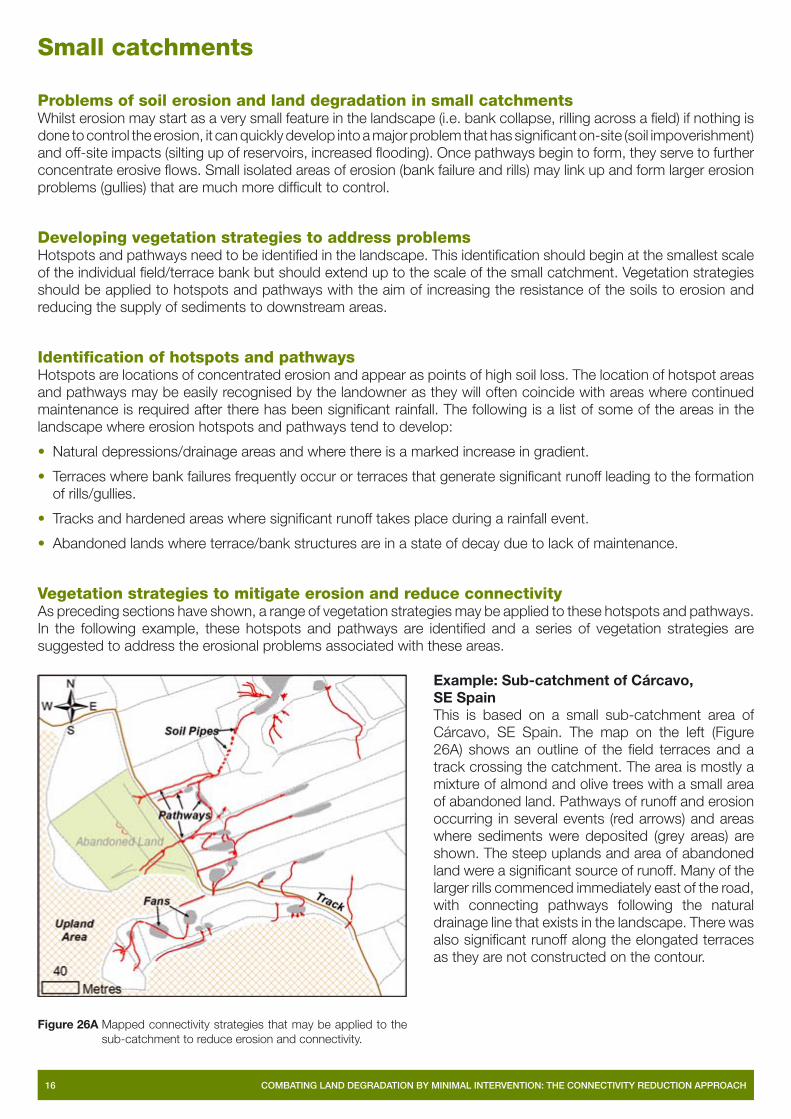
Example: Sub-catchment of Cárcavo, SE SpainThis is based on a small sub-catchment area of Cárcavo, SE Spain. The map on the left (Figure 26A) shows an outline of the fi eld terraces and a track crossing the catchment. The area is mostly a mixture of almond and olive trees with a small area of abandoned land. Pathways of runoff and erosion occurring in several events (red arrows) and areas where sediments were deposited (grey areas) are shown. The steep uplands and area of abandoned land were a signifi cant source of runoff. Many of the larger rills commenced immediately east of the road, with connecting pathways following the natural drainage line that exists in the landscape. There was also signifi cant runoff along the elongated terraces as they are not constructed on the contour.
Figure 26A Mapped connectivity strategies that may be applied to the sub-catchment to reduce erosion and connectivity.

COMBATING LAND DEGRADATION BY MINIMAL INTERVENTION: THE CONNECTIVITY REDUCTION APPROACH 17
The map on the right (Figure 26B) gives an outline of the suggested strategies that should be applied to the hotspot areas and pathways to reduce the potential connectivity in the landscape. These can be summarised as follows:
• Establish more vegetation on terrace banks. Suitable species include grasses like Lygeum spartum, Brachypodium retusum and Stipa tenacissima in combination with more deeper rooted shubs like Anthyllis cytisoides, Atriplex halimus or Salsola genistoides.
• Plant vegetation on fl at terraces of abandoned lands and vegetate banks. Suitable species include Lygeum spartum, Brachypodium retusum and Stipa tenacissima.
• Plant cover crops in tree lanes of all fi elds in winter time (cover up to 50% of fi eld area). Planted cover crops should follow the contour as much as possible. Recommend planting winter annuals and weeds.
• Plant vegetation at sides of tracks. Suitable species include Brachypodium retusum.
• Plant vegetation along the natural drainage line (grassed waterway). Suitable grass species include Brachypodium retusum. Where water accumulates plant Juncus sp.
Types of plants, strategies for planting and growth
Selection of plantsIn choosing plants and developing a vegetation strategy to reduce erosion and sediment connectivity, consideration is given to the characteristics of the plants themselves and the location of the hotspots in the landscape where the strategy is to be applied. Desirable plant characteristics are: dense rooting system; high threshold for removal; ability to trap water and sediments; perennial or persistent; quick growth rate; germinates or propagates easily; endemic species that are not invasive; ability to withstand drought and an ability to grow in a range of substrates. Based on detailed studies, a list of plants which may be considered for developing vegetation strategies has been developed and is outlined in Table 3, overleaf.
Suitability for different types of locationWhile a mixture of grasses and shrubs are recommended for stabilising side-banks and increasing cover in Reforested and Abandoned Lands, it is predominantly grasses that are recommended for reducing erosion and connectivity in the other land-units (Croplands, Hillslopes and Gullies and Channels). In large gullies and channels the use of shrub Nerium oleander and Tamarix canariensis should also be considered, for their high resistance to erosion, potential to decrease fl ow velocities and trapping of sediments.
Figure 26B Vegetation strategies that may be applied to the sub-catchment to reduce erosion and connectivity.

18 COMBATING LAND DEGRADATION BY MINIMAL INTERVENTION: THE CONNECTIVITY REDUCTION APPROACH
Table 3 Potential plants to form part of vegetation strategies and be applied to land unit hotspots.
Note: For Sub-catchments, break up into land-units listed above and then select appropriate plants.
Methods of seeding, planting and encouraging growthOne of the main challenges in new approaches to soil restoration is how to deal with the lack of knowledge on how these plants may be used. In fact, the set of species that have traditionally been used is small and if new species have to be used, experience on nursery, transplant and soil preparation techniques have to be developed, in order to increase success. An alternative and complementary approach would consist of by-passing nursery steps and directly sowing seeds on favourable microsites which are naturally available or artifi cially created using structures.
Grasses and shrubs may be planted directly on defective terraces in Reforested Lands. Planting may be more successful, particularly on side banks if small microstructures are built to promote trapping of water, nutrients and sediments. To counteract the negative effects of the pine litter layer, this may be removed to encourage growth of seeded grasses and shrubs. The use of cover crops to cover the fi elds during the rainy season will reduce erosion in these fi elds. A range of weed, legume and grass cover crops can be considered, though potential costs of application can be avoided if weed species are used. In Cárcavo it is recommended that cover crops should not exceed 50% of the fi eld and be restricted to the lanes between the trees. Where water supply is limited, further consideration may be given to only planting cover crops along drainage lines, edges of fi elds or along access tracks.
Ongoing maintenance of water conservation structures (terraces and side banks) is important for decreasing connectivity, maximizing water usage and increasing vegetation cover in abandoned lands as well as reforested lands and croplands. Repair of failed terrace banks, planting grasses and shrubs on reformed banks and in areas of concentrated fl ow is required. Where natural drainage lines are evident in the landscape, whilst these also represent hotspot areas, they also form areas where water and nutrients are transmitted, providing ideal conditions for the establishment of grassed waterways. Improvements in the effectiveness of grassed waterways have been documented where double drilling techniques have been used.
Land-unit Types of plants
Reforested land
Grasses (Stipa tenacissima and Brachypodium retusum, Helictotrichon fi lifolium) and shrubs (side bank: Salsola genistoides, other hotspots: Rosmarinus offi cinalis, Anthyllis cytisoides [fi rst step], Rhamnus lycioides, Pistacia lentiscus [second step]).
Croplands Weeds, legumes and grass species.
Abandoned lands
Grasses (Lygeum spartum, Brachypodium retusum and Stipa tenacissima) in combination with more deeper rooted shrubs (Anthyllis cytisoides, Atriplex halimus or Salsola genistoides) on terrace wall.
Hillslopes and gullies
Grasses (Stipa tenacissima, Lygeum spartum, Helictotrichon fi lifolium) and shrubs (Salsola genistoides) on steep slopes. Grass species (Brachypodium retusum) and reed species (Juncus acutus) to vegetate drainage lines. For stabilizing gully fl oors a combination of grasses (Lygeum spartum, Stipa tenacissima, Brachypodium retusum), deep rooted shrubs (Salsola genistoides, Anthyllis cytisoides, Atriplex halimus) or trees (Tamarix canariensis) should be considered.
Channels Grasses (Lygeum spartum) on fans. Grasses (Stipa tenacissima, Lygeum spartum) and trees (Tamarix canariensis) to stabilise valley walls. Larger tributaries/channels, consider either trees/shrubs (Fine substrate – Tamarix canariensis, Coarse substrate – Nerium oleander) and grasses (Lygeum spartum). Where water accumulates plant Juncus sp. and Phragmites australis.

COMBATING LAND DEGRADATION BY MINIMAL INTERVENTION: THE CONNECTIVITY REDUCTION APPROACH 19
In seeking to reduce erosion and connectivity to channels, strategies are better applied further up in the headwaters in smaller catchments. Areas of deposition, and in particular where there are fi ne sediments are locations where grasses should be encouraged and planted. The use of structural interventions to alter conditions that favour vegetation establishment may be required in channels, in the situation where there is insuffi cient substrate for planting. Time is then given for sediments to be deposited behind these structures prior to planting; the ponding of water behind the structure can also be benefi cial for improving conditions for plant establishment. In larger channels, efforts should focus on planting of larger shrubs and trees, as these will have the effect of reducing fl ow velocities and hence increasing the potential for sediment storage. While large vegetation could reduce fl ow velocity, overall it is regarded as reducing fl ood capacity because of reduced velocities and increased infi ltration, and hence tradeoffs need to be considered.
Summary and recommendations
SummaryThis booklet comprises a set of guidelines that have been compiled based on detailed studies of vegetation and its positive effects in mitigating erosion and reducing connectivity at a range of scales. The purpose of these guidelines is to provide information on how problems of soil erosion and land degradation may be controlled by the application of innovative vegetation strategies with existing soil conservation measures. These strategies target specifi cally those hotspot areas in the landscape where erosion is a problem at present, or which, if improperly managed, will become a signifi cant problem. The approach is different from other approaches in that it identifi es hotspots and focuses on the application of appropriate vegetation species to these areas, whereas other approaches are applied across the entire landscape. These guidelines are suitable to dryland environments of the Mediterranean region of southern Europe, and they are based on research in SE Spain.
RecommendationsThese guidelines should be used to develop vegetation strategies to mitigate erosion and land degradation at the small catchment scale. More specifi c recommendations that apply to particular land unit and hotspots are listed below:
• In Reforested Lands, microstructures which trap sediments and nutrients could be applied to the side banks and on terraces the needle litter layer removed to improve vegetation establishment.
• On Abandoned Lands existing terraces should be maintained and failures repaired after events. Dense rooted grasses should be planted on reformed banks and in areas of concentrated fl ow.
• Consider correcting terraces that are not constructed on the contour and breaking up long terraces, as these concentrate runoff and contribute to erosion problems downslope.
• Establish winter cover crops in access lanes between trees, but cover should not exceed 50% of terrace. Cover crops should then be killed off at the end of the winter period.
• Plant vegetation cover along edges of tracks, particularly where these cross a drainage line or gradient changes such that the track begins to concentrate runoff.
• Where there are natural drainage lines crossing fi elds establish grassed waterways. Double drilling techniques should also be used when seeding these areas. Establish vegetation on gully fl oors.
• In small channels, revegetation efforts should focus on planting grasses in areas where there are fi ne sediment inputs. Small structures may be built to promote deposition and improve conditions for vegetation establishment.
• In larger channels, efforts should focus on establishing larger shrubs and trees as these will have a greater effect in reducing fl ow velocities and trapping sediments, therefore reducing sediment connectivity to areas downstream.

20 COMBATING LAND DEGRADATION BY MINIMAL INTERVENTION: THE CONNECTIVITY REDUCTION APPROACH
Contribution of RECONDES project to policy
Much research has been undertaken within the European Union (EU) to understand the processes of land degradation and desertifi cation, to develop tools for modelling these processes and predicting impacts under future scenarios of climate and land use change, and to develop early warning systems and assessment of vulnerability. The research is now moving on to address the development of approaches and methods of combating and mitigating desertifi cation. The RECONDES project is a contribution to this, under the Sustainable Development, Global Change and Ecosystems Programme of Framework 6.
The project RECONDES is entitled ‘Conditions for Restoration and Mitigation of Desertifi ed Areas Using Vegetation’. The focus of RECONDES is the mitigation of desertifi cation by the means of innovative techniques using vegetation in specifi c landscape confi gurations prone to severe degradation processes. Its major objective was to produce practical guidelines on the conditions for use of vegetation in areas vulnerable to desertifi cation, taking into account spatial variability in geomorphological and human-driven processes related to degradation and desertifi cation. These guidelines build upon present knowledge of degradation and desertifi cation processes and combine this with ecological knowledge about vegetation to consider strategies for land management at a variety of scales. Successful land management requires a holistic approach and the integration of many disciplines. These guidelines have been written mainly by ecologists, geomorphologists, hydrologists, soil scientists, modellers and those with an involvement with policy and its application.
The RECONDES Project contributes directly to the objectives of the Global Change and Ecosystems Sub-Priority by providing major support to the EU Strategy for Sustainable Development. The innovative knowledge and products, resulting from the scientifi c and technological enhancement of the scientifi c state of the art include up-scaling approaches, new sustainable and environmentally sound eco-engineering methodologies and appraisals for effective management strategies. These products support the world-wide scale strategies (Johannesburg Summit on Sustainable Development, 2002) and strengthen the knowledge for its future orientation. The development in the project RECONDES of guidelines to mitigate desertifi cation by sustainable practices including the use of vegetation is specifi cally devoted to the new EU 6th Environmental Action Plan. These guidelines aim explicitly at solving problems at the source, preventing off-site problems.
The project results also contribute to the priorities set under the UN Convention to Combat Desertifi cation (UNCCD, 1994) and are very suitable for adoption in the Action Plans that are being designed on national or regional level.

MD2029 0507
www.port.ac.uk/research/recondes/
The RECONDES project is funded by the European Commission, Directorate-General of Research, Global Change and Desertifi cation Programme. Project No. GOCE-CT-2003-505361.
Produced by University of Portsmouth, 2007
Sixth Framework Programme
Contributors:
University of Portsmouth Prof Janet HookeDepartment of Geography Dr Peter Sandercock Buckingham Building, Lion Terrace Dr Miguel Marchamalo Sacristán Portsmouth, P01 3HE, United Kingdom
Tel: +44 23 9284 2482Fax: +44 23 9284 2512Email: [email protected]
Universite Catholique de Louvain Prof. Bas van Wesemael Geography Department André Meerkerk Place Louis Pasteur 3, Louvain-la-Neuve1348, Belgium
Tel: +32 1047 2056Fax: +32 1047 2877Email: [email protected]
Consiglio Nazionale Delle Ricerche Dr Dino Torri Istituto Di Ricerca Per La Protezione Idrogeologica Dr Lorenzo Borselli Unità Staccata di Firenze (IRPI-FI) Dr M. Pilar Salvador SanchisPiazzale delle Cascine 15/28, Dr Marta S. YañezFirenze, 50144, Italy
Tel: +39 055 328 8290Fax: +39 055 321 148Email: [email protected]
Consejo Superior de Investigaciones Cientifi cas Dr Victor Castillo Centro de Edafologia y Biologia Aplicada del Segura (CEBAS) Dr Gonzalo González Barberá Department of Soil and Water Conservation José Antonio Navarro Campus Universitario de Espinardo Dr José Ignacio Querejeta Mercader Murcia, 30100, PO Box 164, Spain Dr Carolina Boix-Fayos
Tel: +34 968 396 349Fax: +34 968 396 213Email: [email protected]
Universiteit van Amsterdam Dr Erik Cammeraat Instituut voor Biodiversiteit en Ecosysteem Dynamica (IBED) – Ir. Jan Peter LesschenUniversiteit van Amsterdam, Nieuwe Achtergracht 166NL 1018 WV, Amsterdam
Tel: +31 20 525 5890Fax: +31 20 525 7431Email: [email protected]
Katholieke Universiteit Leuven Prof. Jean PoesenPhysical and Regional Geography Research Group Sarah De Baets K.U. Leuven, GEO-INSTITUTECelestijnenlaan 200 E, B-3001 Heverlee, Belgium
Tel: +32 1632 6425Fax: +32 1632 2980Email: [email protected]