Embed Size (px)
Citation preview

Why are we not looking forward
to co-teachability?
Why is it hard to teach one class with students
sitting exams for two
qualifications?
Any ideas to share?
Welcome!Please join one of 5 groups• Tectonics• Glaciation• Coasts• Globalisation• Rebranding Places
Co-teaching the new Edexcel AS and A level
Daniel MacePrincipal Examiner, GCE Geography
Co-teaching the new Edexcel AS and A level
5:35-6:25pm

The new courses
Our new AS/A level qualifications support success in geography with:
• the contemporary issues-based approach teachers and students love
• straightforward specifications you can shape to suit your students
• a manageable and meaningful approach to fieldwork
• exams that give every student the chance to succeed
• a focus on the skills at the heart of being a good geographer
• expert support every step of the way.

Assessment principles
• Our assessment structure is straightforward to navigate
• Questions ramp in demand within each section and across the qualification as a whole.
• There is a clear and consistent relationship between command words, mark tariffs and skills.
• Levels based mark schemes are explicit about the skills required in the extended response questions.
• The coursework requires a range of skills, particularly independent study, research and extended-writing skills, that will prepare students for higher education.
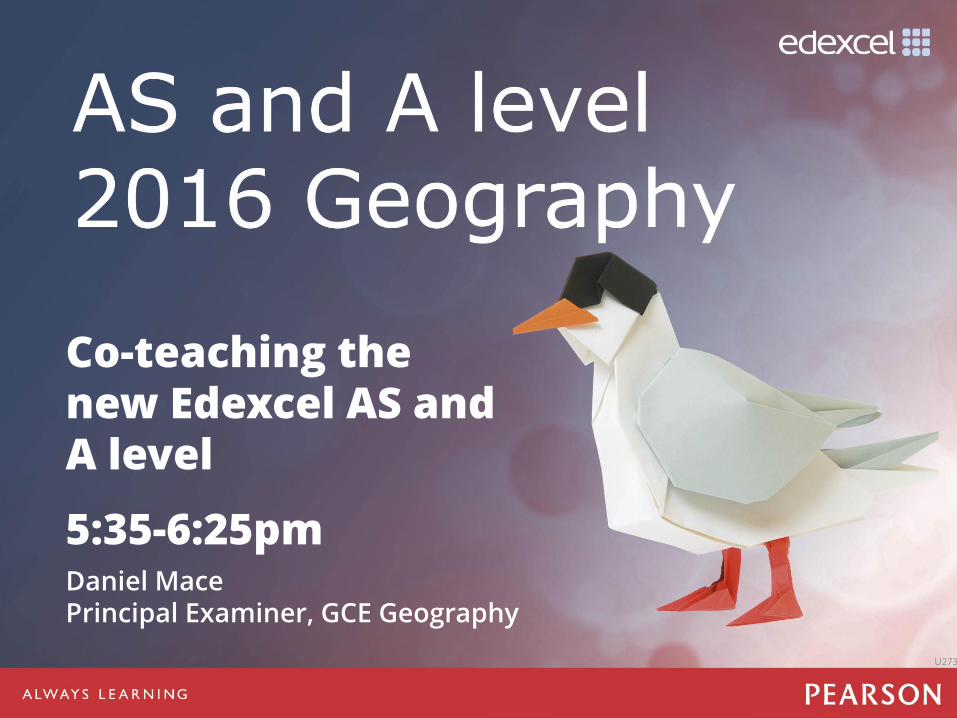
AS assessment overview
Paper 1 Paper 2
1 hour and 45 minutes50% of the qualification
90 marks
1 hour and 45 minutes50% of the qualification
90 marks
Must answer Section A and…either Section B or Section C
• Section A: Tectonic Processes and Change
• Section B: Glaciated Landscapes and fieldwork
• Section C: Coastal Landscapes and fieldwork
Must answer Section A and…either Section B or Section C
• Section A: Globalisation
• Section B: Regenerating Places and fieldwork
• Section C: Diverse Places and fieldwork
• May include MCQs, short open response, calculations and resource Qs
• Includes 6-mark, 9-mark, 12-mark and 16-mark extended writing Qs
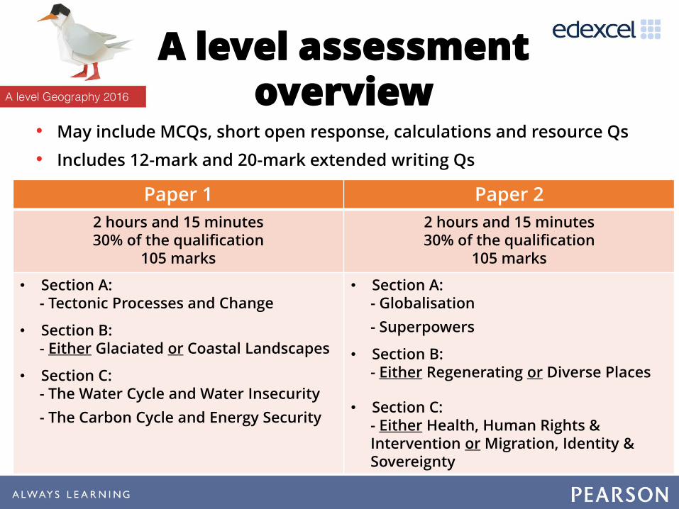
A level assessment overview
Paper 1 Paper 2
2 hours and 15 minutes30% of the qualification
105 marks
2 hours and 15 minutes30% of the qualification
105 marks
• Section A: - Tectonic Processes and Change
• Section B: - Either Glaciated or Coastal Landscapes
• Section C: - The Water Cycle and Water Insecurity
- The Carbon Cycle and Energy Security
• Section A: - Globalisation
- Superpowers
• Section B: - Either Regenerating or Diverse Places
• Section C:- Either Health, Human Rights & Intervention or Migration, Identity & Sovereignty
• May include MCQs, short open response, calculations and resource Qs
• Includes 12-mark and 20-mark extended writing Qs

A level assessment overview
Paper 3 Independent Investigation
2 hours and 15 minutes20% of the qualification
70 marks
Coursework20% of the qualification
70 marks
Synoptic Investigation:
Resource booklet contains information about geographical issues within a place-based context.
This links to the 3 synoptic themes
and is rooted in 2 or more of the compulsory content areas.
Must answer all Qs in Sections A, B & C
Includes 8-mark, 18-mark and 24-mark extended writing Qs
Written report:
• Purpose of investigation: 12 marks
• Field methodologies: 10 marks
• Data representation & analysis: 24 marks
• Conclusion & evaluation: 24 marks
Total: 70 marks
• Internally assessed
• Externally moderated
• Recommended 3000-4000 word limit

AS command words: ‘point marked’
Command Word Definition
Identify/Give/Name/State Recall or select one or more pieces of information.
Define State the meaning of a term.
Calculate Produce a numerical answer, showing relevant working.
Draw/plot Create a graphical representation of geographical information.
CompleteCreate a graphical representation of geographical information by adding detail to a resource that has been provided.
DescribeGive an account of the main characteristics of something or the steps in a process. Statements in the response should be developed but do not need to include a justification or reason.
CompareFind the similarities and differences of two elements given in a question. Each response must relate to both elements, and must include a statement of their similarity/difference.
SuggestFor an unfamiliar scenario, provide a reasoned explanation of how or why something may occur. A suggested explanation requires a justification/exemplification of a point that has been identified.
Explain Provide a reasoned explanation of how or why something occurs. An explanation requires understanding to be demonstrated through the justification or exemplification of points that have been identified.

AS command words – ‘levels marked’
Explain
(6 marks)
Provide a reasoned explanation of how or why something occurs. An explanation requires understanding to be demonstrated through the justification or exemplification of points that have been identified.
Assess
(9 or 12 marks)
Use evidence to determine the relative significance of something. Give balanced consideration to all factors and identify which are the most important.
Evaluate
(16 marks)
Measure the value or success of something and ultimately provide a balanced and substantiated judgement/conclusion. Review information and then bring it together to form a conclusion, drawing on evidence such as strengths, weaknesses, alternatives and relevant data.
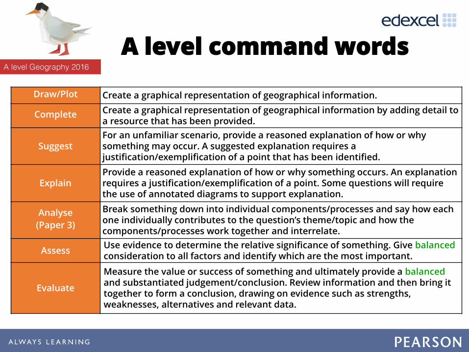
A level command words
Draw/Plot Create a graphical representation of geographical information.
Complete Create a graphical representation of geographical information by adding detail to a resource that has been provided.
SuggestFor an unfamiliar scenario, provide a reasoned explanation of how or why something may occur. A suggested explanation requires a justification/exemplification of a point that has been identified.
Explain Provide a reasoned explanation of how or why something occurs. An explanation requires a justification/exemplification of a point. Some questions will require the use of annotated diagrams to support explanation.
Analyse
(Paper 3)
Break something down into individual components/processes and say how each one individually contributes to the question’s theme/topic and how the components/processes work together and interrelate.
AssessUse evidence to determine the relative significance of something. Give balancedconsideration to all factors and identify which are the most important.
Evaluate
Measure the value or success of something and ultimately provide a balancedand substantiated judgement/conclusion. Review information and then bring it together to form a conclusion, drawing on evidence such as strengths, weaknesses, alternatives and relevant data.
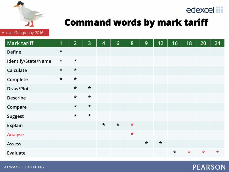
Command words by mark tariff
Mark tariff 1 2 3 4 6 8 9 12 16 18 20 24
Define *
Identify/State/Name * *
Calculate * *
Complete * *
Draw/Plot * *
Describe * *
Compare * *
Suggest * *
Explain * * *
Analyse *
Assess * *
Evaluate * * * *

Extended writing and LBMS
Total AO1 AO2 AO3
AS
Explain 6 6
Fieldwork Questions - Assess 9 9
Assess 12 3 9
Synoptic Questions - Evaluate 16 4 12
A level
Explain 6 6
Explain (resource-based) 6 3 3
Explain 8 8
Assess 12 3 9
Evaluate 20 5 15
Synoptic Paper - Analyse 8 4 4
Synoptic Paper - Evaluate 18 3 9 6
Synoptic Paper - Evaluate 24 4 12 8

Thinking Skills

• Our memories are formed by the pieces of information that we really think about.
• We cannot remember everything. • The ‘cues’ that we use to retrieve our memories
help us to access a greater level of information.
#1 – Getting back to pedagogy
What improves a students’ memory?
Source: Daniel Willingham, in Martyn Simmonds ‘Making Them Think Hard’

Peterborough Learning Partnership, April 2015, in Simmonds ‘Making Them Think Hard’; Graphics by www.penmendonca.com.
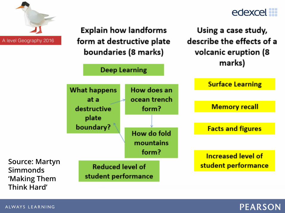
Source: Martyn Simmonds ‘Making Them Think Hard’

Q Do you know what high ability students should know and be able to do in your subject?
Q Do you know the hardest questions they are expected to answer in their exams?
Q Do you plan specific ‘think hard’ questions for students to do in lessons, in order to support their learning in these areas?
Thinking Hard

Who…
What…
When...
Where...
Why…
How…
What if…
Should…Could…
Use the question prompts to design ‘thinking hard’ lesson
objectives that might match the content from the specification.
1.5 Tectonic hazard profiles are important to an understanding of contrasting hazard impacts, vulnerability and resilience.
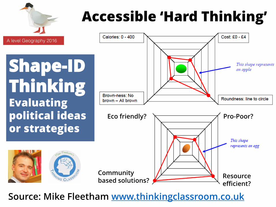
Shape-ID ThinkingEvaluating political ideas or strategies
Eco friendly? Pro-Poor?
Resource efficient?
Community based solutions?
Source: Mike Fleetham www.thinkingclassroom.co.uk
Accessible ‘Hard Thinking’
More Ideas?

Supporting great geography teaching
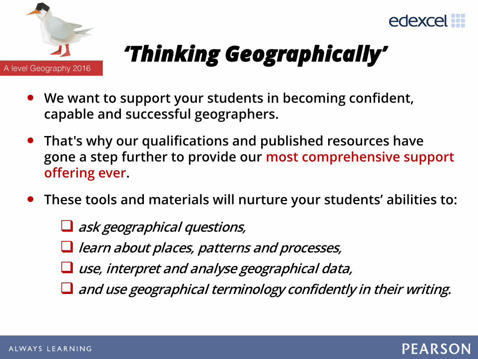
‘Thinking Geographically’
• We want to support your students in becoming confident, capable and successful geographers.
• That's why our qualifications and published resources have gone a step further to provide our most comprehensive support offering ever.
• These tools and materials will nurture your students’ abilities to:
ask geographical questions,
learn about places, patterns and processes,
use, interpret and analyse geographical data,
and use geographical terminology confidently in their writing.
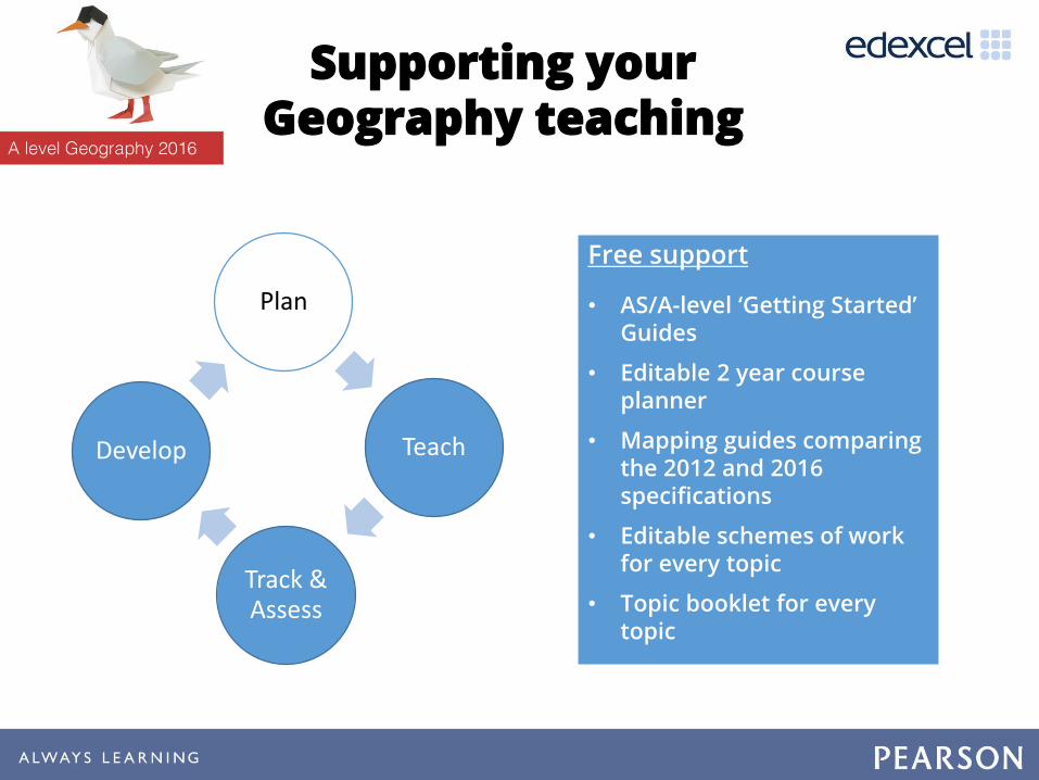
Supporting your Geography teaching
Plan
Teach
Track & Assess
Develop
Free support
• AS/A-level ‘Getting Started’ Guides
• Editable 2 year course planner
• Mapping guides comparing the 2012 and 2016 specifications
• Editable schemes of work for every topic
• Topic booklet for every topic

Plan
Teach
Track & Assess
Develop
Free support
• Field-trip and data skills worksheets
• Case studies of good fieldwork practice
• Maths for Geography guide
• GIS lesson plans and worksheets
Published resources
• Student Book designed for the new spec (available as Kindle editions)
Supporting your Geography teaching
Thinking Geographically: Maths and statistics
• Based on the proven approach of Pearson Maths
• A teacher guide clearly detailing what was learnt in their GCSE Maths lessons and building on this to scaffold their geographical skills
• Ensuring terminology and approach is consistent with Maths department, so students can make links between the subjects.
• Worksheets building confidence and fluency to master problem-solving and reasoning activities that model maths and statistical concepts in a geographical context
• Supporting students in strengthening, checking and testing their skills through the Pearson ‘Progression Scale’

Plan
Teach
Track & Assess
Develop
Free support
• Additional specimen papers
• Literacy Guide: Exemplars, examiner commentaries, guidance on common issues
• Independent Investigation guidance, support and exemplars
• .esultsPlus
• examWIzard
Published resources
• Advice from assessment experts• Contextualised exam questions• Annotated sample answers• Exam tips
Supporting your Geography teaching

• Based on the proven approach of ‘Grammar for Writing’ (Pearson English)
• Working with Exeter University, the approach to our geography qualifications will help teachers support literacy
• Exeter University will analyse student exam scripts, including sample exam questions sat by centres in March 2016, and provide guidance on common literacy issues at all ability levels
• This will be used throughout our ongoing support so that students can be confident in their extended writing and make progress.
Thinking Geographically: Literacy

Pearson Progression Services 11-16
Progression Scale
Progression Maps
Assessments Markbooks
A 12-step scale* designed to support learner progress throughout Key Stage 3 and Key Stage 4
Detailed, editable maps which include progress descriptors, prerequisites and boosters at a sub-topic level mapped to the Progression Scale
Assessments** to test learners’ understanding at key points in the learning cycle, underpinned by the Progression Scale
Excel markbooks to record learners’ performance across each assessment, underpinned by the Progression Scale
** We provide the following assessments for free: Key Stage 3 baseline; Edexcel GSCE baseline; Edexcel GCSE end of year. We also provide a number of additional assessments (e.g. end of topic, end of term, problem-solving, fluency) which are paid-for resources
* A scale of 12 has been used to grade content and skills, and is calibrated to provide a simple measurement system where theexpectation is that a student will achieve development of skills spanning one step of progress in an academic year. (Note: MFL differs here.)

Plan
Teach
Track & Assess
Develop
When it comes to Professional Development, we’re planning events & workshops to support first teaching and beyond, in response to your feedback:
• ‘Fieldwork, data skills & the independent investigation’ in collaboration with the RGS
• Synoptic thinking skills and extended writing
• Progression tracking and intervention strategies
If you would like support in other areas, then please let us know on the Evaluation Form in your delegate packs
Supporting your Geography teaching
Published resources
• Edexcel AS/A-level resources*
o Brand-new suite of print and digital resources
o Thinking Geographically approach embedded throughout
o Integrated fieldwork support
o Support for assessing progress
• Student Book and ActiveBook (e-book)
• ActiveLearn Digital Service
*You don’t need to purchase resources to deliver our qualifications. These resources have not yet been endorsed. This information is correct as of 28th January 2016, but may be subject to change.

We are working with a range of publishers who are looking towards getting their resources* endorsed:
• Hodder Education
• Oxford University Press
• Pumpkin Interactive
• ZigZag Education.
*You don’t need to purchase resources to deliver our qualifications. These resources have not yet been endorsed. This information is correct as of 13th Feb 2016, but may be subject to change.
Other published resources
More support…
• Join us at Stands 12 and 13 to find out more!
• Sign up to Jon Wolton’s updates: email [email protected].
• Visit the website for support materials: www.edexcel.com/geography.