Embed Size (px)
Citation preview
Clovis is the earliest well-documented tech-nocomplex in the southwestern UnitedStates and northwestern Mexico and likely
represents the archaeological record of the initialhunter-gatherer populations to colonize the regionduring the late Pleistocene. The greater South-west region includes many well-known Clovissites, including the famous cluster of Clovis sitesin the San Pedro River Valley, Arizona (Haury etal. 1953; Haury et al. 1959; Haynes and Huckell
2007; Hemmings and Haynes 1969), several sitesin western Sonora (Gaines et al. 2009; Robles Or-tiz 1974; Sánchez 2001, 2010), and numerous iso-lated finds throughout the region (Figure 1). Ad-ditionally, several Clovis sites occur on theneighboring Southern Plains, including the Clovistype site, Blackwater Draw Locality #1 (Boldurianand Cotter 1999; Hester 1972), Lubbock Lake(Holliday 1997; Holliday et al. 1994; Johnson1987), Miami (Holliday et al. 1994; Sellards
CLOVIS PALEOECOLOGY AND LITHIC TECHNOLOGY IN THE CENTRAL RIO GRANDE RIFT REGION, NEW MEXICO
Marcus J. Hamilton, Briggs Buchanan, Bruce B. Huckell, Vance T. Holliday, M. Steven Shackley, and Matthew E. Hill
Clovis sites occur throughout the southwestern United States and northwestern Mexico, but are poorly documented in thecentral Rio Grande rift region. Here, we present data from two relatively unknown Clovis projectile point assemblages fromthis region: the first is from the Mockingbird Gap Clovis site and the second is from a survey of the surrounding region.Our goals are to reconstruct general features of the paleoecological adaptation of Clovis populations in the region usingraw material sourcing and then to compare the point technology in the region to other Clovis assemblages in the Southwestand across the continent. Our results show that both assemblages were manufactured from similar suites of raw materialsthat come almost exclusively from the central Rio Grande rift region and the adjacent mountains of New Mexico. Addi-tionally, we show that Clovis projectile points in the study region are significantly smaller than the continental average.Our results suggest that Clovis populations in this region operated within a large, well-known, and relatively high-eleva-tion territory encompassing much of northern and western New Mexico.
Sitios de la cultura Clovis ocurren por toda la región sudoeste de los Estados Unidos y el noroeste de México, pero no estánbien documentados en la región del Rift de Río Grande. Presentamos datos de dos ensamblajes de puntas de proyectil relati-vamente desconocidos de esta región: el primero es del sito Mockingbird Gap y el segundo es de una inspección del área alrededor de este sito. Nuestras metas eran reconstruir las características generales de la adaptación paleoecológica de lapoblación Clovis en la región usando la identificación de la proveniencia de materias primas, y luego comparar la tecnolo-gía de puntas en la región a otros ensamblajes de la cultura Clovis. Nuestros resultados demuestran que ambos ensamblajesfueron creados con juegos de materias primas que provienen casi exclusivamente de la región del Rift de Río Grande y lasmontañas colindantes de Nuevo Mexico. Adicionalmente, demostramos que las puntas de proyectil Clovis en la región de estu-dio son significativamente mas pequeñas que el promedio en el continente. Nuestros resultados sugieren que las poblacionesClovis en esta región operaban dentro de un territorio grande, bien conocido, y de elevación relativamente alta que cubríauna gran parte del norte y el oeste de Nuevo Mexico.
Marcus J. Hamilton � Santa Fe Institute, 1399 Hyde Park Road, Santa Fe, New Mexico 87501 and Departments ofAnthropology and Biology, University of New Mexico, Albuquerque, New Mexico 87131 ([email protected])Briggs Buchanan � Department of Archaeology, Simon Fraser University, Burnaby, British Columbia, V5A 1S6, CanadaBruce B. Huckell � Department of Anthropology, University of New Mexico, Albuquerque, New Mexico 87131Vance T. Holliday � Departments of Anthropology and Geosciences, University of Arizona, Tucson, Arizona 85721M. Steven Shackley � Geoarchaeological XRF Laboratory, Department of Anthropology, University of California,Berkeley, California 94704Matthew E. Hill � Department of Anthropology, University of Iowa, Iowa City, Iowa 52242
American Antiquity 78(2), 2013, pp. XX-XXCopyright ©2013 by the Society for American Archaeology
1
AQ78(2)Hamilton_Layout 1 2/7/13 11:08 AM Page 1

2 AMERICAN ANTIQUITY [Vol. 78, No. 2, 2013
1938), and Domebo (Leonhardy 1966). In con-trast, relatively little is known about the Clovis oc-cupation of the central Rio Grande rift region.Here we describe and analyze two relatively
unknown Clovis projectile point assemblagesfrom the central Rio Grande rift region of NewMexico (Figure 2). The first assemblage includes223 projectile points from the Mockingbird Gapsite (Holliday et al. 2009; Huckell et al. 2006;Huckell et al. 2007; Huckell et al. 2008; Judge1973; Weber and Agogino 1997), located south-east of Socorro, New Mexico, and the second as-semblage includes 70 surface-collected projectilepoints from a survey of the greater central RioGrande rift region (Figure 3). Both assemblageswere collected, catalogued, and curated over a pe-riod of about 60 years by Robert H. Weber,1 a ge-ologist for the New Mexico Bureau of Geologyand Mineral Resources and an avocational ar-chaeologist. The artifacts are currently housed atthe Museum of Indian Arts and Culture in SantaFe, New Mexico.Our analyses of the Clovis projectile point as-
semblages from the central Rio Grande rift regionfocus on two aspects of the data: (1) the locationand distribution of known raw material sourcesfor Clovis projectile points found in the regionand (2) comparisons of the dimensions of Clovis
points in the study region with Clovis assem-blages in the greater Southwest and SouthernPlains and from across the continent. We inferfrom these analyses that the central Rio GrandeClovis population had extensive knowledge of abroad and diverse geographic region extendingfrom the Mogollon Mountains in the south to theColorado Plateau in the north, and from the RioGrande rift region in the east to the mountains ofwestern New Mexico and eastern Arizona in thewest. We also show that Clovis projectile pointtechnology in the Rio Grande rift region sharesbroad similarities with other Clovis assemblagesin the greater Southwest and across the continentin general.
Regional Setting, Geology, and Paleoecologyof the Central Rio Grande Rift Region
The Mockingbird Gap site is situated about 60 kmsoutheast of the town of Socorro, and about 30 kmeast of the Rio Grande at the northern end of theJornada del Muerto (Figure 1). The site was firstdiscovered in the late 1950s by Robert H. Weber.The Mockingbird Gap site covers an area of about800 m by 150 m along a low-lying gravel ridgeadjacent to Chupadera Wash (Holliday et al.2009). The surface-collected artifacts come from
Figure 1. The greater southwest U.S./northern Mexico region.
AQ78(2)Hamilton_Layout 1 2/7/13 11:08 AM Page 2
two primary concentrations, a northern clusterand a southern cluster, both of which seem tohave an internal substructure of artifacts suggest-ing spatially and/or temporally discrete occupa-tion events (Hamilton 2008). Two limited exca-vation projects have been conducted at the site.The first project focused on a locality in the south-ern cluster and took place between 1966 and 1967under the direction of George Agogino of EasternNew Mexico University (ENMU) (Weber andAgogino 1997). The second project was initiatedin 2005 in the area of the ENMU excavations, butin 2007 was focused in the northern cluster at a lo-cality referred to as Locus 1214 under the direc-tion of Bruce Huckell and Vance Holliday (Hol-liday et al. 2009; Huckell et al. 2006; Huckell etal. 2007; Huckell et al. 2008). In this paper, we in-clude projectile points recovered from these ex-cavations.The Rio Grande rift valley stretches from the
southern Rocky Mountains south into northernMexico, where it merges with the basin and rangeprovince of the Mexican Cordillera, separating theColorado Plateau and basin and range of thesouthwest U.S. in the west from the North Amer-ican craton in the east (Figure 1). The Rio Granderift is a broader structural complex that flanksand encompasses the valley (Hawley 2005). Thetopography of the study region is complex and di-verse, ranging from relatively low-lying basins~900 m asl to high-elevation ranges > 4,200 masl. The Late Cretaceous Laramide orogeny(~80–50 MYA) resulted in the uplift of inter-montane western North America, creating muchof the modern topography. The Rio Grande riftbegan forming ~35 million years ago during theLate Cenozoic due to widespread crustal exten-sion and shearing throughout the region (Smith2004). This crustal extension and shearing re-sulted in the formation of a series of north-southtrending half-grabens along what is now the RioGrande rift valley (Hawley 2005). This riftingled to the evolution of the northern Rio Grandeand the subsequent deposition of intermontane al-luvium along the river valley, known as the SantaFe Group. The combination of the Laramideorogeny, the block-fault formations of the basins,the formation of the Rio Grande River Valley,and the localized volcanism associated with theLate Cenozoic crustal extension created a land-
scape rich in primary and secondary deposits ofhigh quality lithic raw materials, including cherts,chalcedonies, rhyolites, and obsidians. Theselithic raw materials were used to make tools byClovis populations of the region, as well as bysubsequent cultures over the following 13,000years.The Rio Grande rift region lies at the far north-
ern extent of the Chihuahuan Desert and cur-rently is characterized primarily by desert grass-lands at low elevations and mixed conifer forestat high elevations (Van Devender 1995). Packratmiddens in the San Andres Mountains of NewMexico suggest that during the Late Pleistocenehigher elevations were dominated by mixedconifer forests above ~1,700 m, grading into ju-niper woodlands and pinyon-juniper-oak wood-lands on rocky slopes at lower elevations. Thesethen graded into grassland-savannahs in the riverbasins, while riparian corridors likely maintainedgallery forests (Van Devender 1990). The pres-ence of C4 grasses and shrubs in packrat middensfrom the Big Hatchet Mountains in the bootheelof New Mexico indicates an intact monsoonalregime southwest of the Jornada del Muerto(Holmgren et al. 2007). The lack of C3 shrubs sug-gests cold winters (Van Devender 1990). Annualprecipitation during the Late Pleistocene was bi-modal and would have followed predictable ele-vational and latitudinal gradients (Holmgren et al.2007). The hydrology of the region during theLate Pleistocene was composed of widespreadlake systems throughout northern Mexico (Reeves1969; Van Devender 1990) and the U.S. South-west (Allen 2005; Allen and Anderson 2000; An-derson et al. 2002), some of which were inter-connected. However, by the end of the LatePleistocene these lakes had receded substantiallyfrom their recorded high stands (Holmgren et al.2003; Van Devender 1990).Paleoecological data are also available from
the Mockingbird Gap site. Geoarchaeologicalcoring of Chupadera Wash, currently a dry, shal-low drainage with localized arroyo developmentlocated immediately to the west of the site, re-vealed that the wash was deeply incised (~10mbelow the site and the present floor) during theClovis period and occupied by a stream or wet-land or both, and possibly spring fed (Holliday etal. 2009; Huckell et al. 2008). This wetland envi-
Hamilton et al.] CLOVIS PALEOECOLOGY AND LITHIC TECHNOLOGY 3
AQ78(2)Hamilton_Layout 1 2/7/13 11:08 AM Page 3
ronment likely would have attracted game alongthe arroyo, providing plentiful hunting and gath-ering opportunities for Clovis foragers. As such,the geoarchaeological and paleoecological set-ting of Mockingbird Gap is not unlike other earlyPaleoindian sites on the Southern High Plains,such as Lubbock Lake and Blackwater Draw(Holliday 1997; Holliday et al. 2009). In effect,the central Rio Grande Valley would have of-fered the benefits of a Plains-like foraging envi-ronment with the additional benefit of local accessto high quality lithic raw materials and a wide di-versity of ecosystems.
The Assemblages
The Mockingbird Gap Projectile Point AssemblageThe Mockingbird Gap Clovis assemblage con-tains a total of 222 points (Table 1). Twenty-seven of the projectile points from MockingbirdGap are complete (12 percent), while the rest arebasal, midsection, or tip fragments. During the ex-cavation seasons completed in 2005 and 2007,
four incomplete points were recovered, two on thesurface and two in situ from excavations (Huck-ell et al. 2006; Huckell et al. 2008).The complete points at Mockingbird Gap in-
clude diagnostic Clovis points as well as what ap-pear to be miniature points manufactured onflakes. The normal-sized Clovis points exhibitthe suite of diagnostic characteristics common toClovis projectile points, including bifacial flaking,basal fluting, and ground margins. The miniaturepoints exhibit several of the same attributes butare unusually small in comparison to typical Clo-vis points (Weber and Agogino 1997). Some ofthe miniature points appear simply to be heavilyresharpened points, whereas others appear to havebeen manufactured from small preforms. There isalso evidence of point reworking where largepoint fragments were being manufactured intonew points. We return to this issue in greater de-tail below.The Survey Collection Projectile Point AssemblageThe central Rio Grande rift region survey collec-tion consists of 70 Clovis points, including com-
4 AMERICAN ANTIQUITY [Vol. 78, No. 2, 2013
Table 1. Absolute and Relative Frequencies of Projectile Points and Preforms from Mockingbird Gap and SurveyCollection by Condition.
Mockingbird Gap Survey CollectionFrequency % of total points % of sub- category Frequency % of total points % of sub-category
Total points 222 70
Complete pointsPreform 3 .11 3 .30Finished 24 .89 7 .70Total 27 .12 10 .14
Fragmentary pointsPreform fragmentsbase 41 .21 2 .03base/midsection 4 .02 3 .05midsectiontip 13 .07fragment 8 .04Subtotal 66 .34 5 .08
Finished fragmentsbase 46 .24 49 .82base/midsection 72 .37 4 .07midsection 2 .01tip 1 .01 2 .03fragment 8 .04
Subtotal 129 .66 55 .92Total 195 .88 60 .86
AQ78(2)Hamilton_Layout 1 2/7/13 11:08 AM Page 4
plete points and fragments (Table 1). These artifactswere also collected by Robert H. Weber during hisregional surveys of Socorro and Catron counties inwestern New Mexico (Figure 2). This survey re-gion encompasses several thousand square kilo-meters of the central Rio Grande rift region andwestern mountains of New Mexico. Several majorriver drainages were covered by the surveys, in-cluding parts of the Rio Grande, Rio Salado, andRio Puerco, which flow through this region fromhigh-elevation coniferous forests to the grasslands
and Chihuahuan desert scrub of the Rio Grande riftregion and the Jornada del Muerto.The projectile points from the survey were re-
covered primarily from three areas of the study re-gion (Figure 3): (1) the northern Jornada delMuerto (n = 54 points), from about 1,290–1,500m asl, particularly in the Chupadera Arroyodrainage system and associated springs, both up-stream from Mockingbird Gap toward ChupaderaMesa and downstream into the Jornada delMuerto basin; (2) the Plains of San Agustin (n =
Hamilton et al.] CLOVIS PALEOECOLOGY AND LITHIC TECHNOLOGY 5
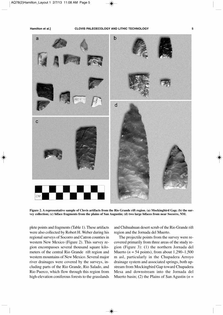
Figure 2. A representative sample of Clovis artifacts from the Rio Grande rift region. (a) Mockingbird Gap; (b) the sur-vey collection; (c) biface fragments from the plains of San Augustin; (d) two large bifaces from near Socorro, NM.
AQ78(2)Hamilton_Layout 1 2/7/13 11:08 AM Page 5

10 points), from above 2,100 m asl, as well as acluster of finds at the northern end of the San Ma-teo Mountains in the pass leading into the Plainsof San Agustin; and (3) the eastern edge of theMagdalena Mountains along the western side ofthe Rio Grande (n = 6 points), from about 1,800m asl. Finds in this area are associated with twosprings, Torreon and Molino in the foothills of theMagdalena Mountains. Finally, a cluster of fourpoints was discovered on the eastern slope of So-corro Mountain near the town of Socorro. This isthe same region as some of the known silicified-rhyolite raw material sources.
Methods
Digitization of PointsThe digitizing method we used to analyze thepoints was the same as the method employed byBuchanan (2005), Buchanan and Collard (2007),and Buchanan and Hamilton (2009). Digital im-ages of artifacts were imported into the Thin PlateSpline Digitizing program (Version 2.02) (Rohlf
2004). Thirty-two landmarks were used to definethe edges and base of each point, and the coordi-nate data were used to compute area and inter-landmark distances in Matlab 6.0. Here we focuson four characters: point area, basal width, mid-line length, and overall length. Point area is cal-culated as the area enclosed by the 32 landmarksoutlining each specimen. The square root of themeasure is then taken to make the units the sameas basal width. Basal width is the width of thebase between the two corners. Midline length iscalculated as the distance from the tip landmarkto the midpoint of the basal concavity. Overalllength is calculated as the distance from the tiplandmark to the midpoint of the segment betweenthe basal landmarks. We use these measures forthe following reasons. Point area is a robust mea-sure of point size and shape, but by definition, isrestricted solely to the analysis of complete points.In addition, point area can be affected by the uselife of the point, where resharpening, for example,can change aspects of the original shape of thepoint. Although a much simpler measure, basalwidth allows us to increase the sample size of an-
6 AMERICAN ANTIQUITY [Vol. 78, No. 2, 2013
Figure 3. The Rio Grande rift region and surrounding area. The white oval delineates the approximate extent of the sur-vey collection.
AQ78(2)Hamilton_Layout 1 2/7/13 11:08 AM Page 6
alyzed points substantially and largely circum-vents the issue of resharpening, as resharpening ismost frequently concentrated on the retooling ofthe blade segment of the point and rarely impactsthe hafting element (Judge 1973). An exception tothis, however, may be in cases where large pointblade fragments are reworked into new points. Weused the difference between the overall and mid-line lengths as a measure of the depth of the basalconcavity of points.We estimated missing values for the nearly
complete points. This was accomplished with theexpectation-maximization missing-data replace-ment method, which uses information about co-variation among variables to predict missing val-ues (Strauss et al. 2003). Simulations havedemonstrated that expectation-maximization es-timation is more precise and reliable than princi-pal-component estimation when using a moderatenumber of characters and large sample sizes(Strauss et al. 2003).
Statistical MethodsStatistical tests for the comparison of projectilepoint assemblages (t test), the analysis of basalmorphology and raw material type (ANOVA),and the gradient model (OLS regression) wereperformed in Minitab v15. We conducted the Kol-mogorov-Smirnov and t tests in PASW (SPSS)18. All the other analyses were conducted inMATLAB 6.0 (release 12), using statistical func-tions written by R. E. Strauss (www.faculty.biol.ttu.edu/Strauss/Matlab/matlab.htm).
Results
Analysis 1: Lithic Raw Material Selection inthe Central Rio Grande Rift RegionLithic Raw Material Selection in the MockingbirdGap Assemblage. The majority of projectilepoints at Mockingbird Gap were manufacturedwith raw materials from sources located within
Hamilton et al.] CLOVIS PALEOECOLOGY AND LITHIC TECHNOLOGY 7
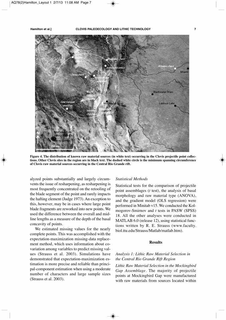
Figure 4. The distribution of known raw material sources (in white text) occurring in the Clovis projectile point collec-tions. Other Clovis sites in the region are in black text. The dashed white circle is the minimum spanning circumferenceof Clovis raw material sources occurring in the Central Rio Grande rift.
AQ78(2)Hamilton_Layout 1 2/7/13 11:08 AM Page 7

about 50 km from the site (Figure 4) (Weber andAgogino 1997); however, the less abundant rawmaterials indicate an almost exclusive use of lithicsources to the north and west of the site.The most abundant raw material at Mocking-
bird Gap is “Socorro jasper” (Dello-Russo 2004)(Figure 5a, Table 2), a term used to describe a dis-tinctive dark red to dull yellow jasper that out-crops at various places within the northeasternpart of the Mogollon-Datil volcanic field (Cham-berlin and Eggleston 1999; Osburn and Chapin1983). One such outcrop is within Black Canyonin the northern Chupadera Mountains, some 11.5km southwest of Socorro. It is likely the productof the alteration of intra-cauldron ash flow tuffs tojasperoids during the late Oligocene by silica-and ferromagnesian-rich hydrothermal fluids cir-culating within fracture zones in the earlierOligocene Socorro Cauldron. At the BlackCanyon quarry (Dello-Russo 2004), this highquality jasperoid appears as localized dikes, partof the Upper Jasperoidal Subzone of Chamberlinand Eggleston (1999:54–59).The Black Canyon quarry is approximately
45 km west of the site (Figure 4); other outcropsare present farther to the west. The toolstonewithin these sources varies in quality from fine-grained rhyolites to an almost quartzite-likecoarseness, and ranges in color from deep maroonto red and yellow. An XRF analysis conducted byDello-Russo (2004) found a probable match be-tween a single Clovis point from MockingbirdGap and material from the Black Canyon quarry.Several site visits to the Black Canyon rhyolitequarry by the authors revealed abundant evidenceof prehistoric quarrying, including evidence of thebifacial reduction of high quality rhyolite consis-tent with Clovis technology.The second most abundant raw material rep-
resented in the Mockingbird Gap assemblage is agreen-grey-black chert, which varies widely inquality (Figure 5a, Table 2). The source of thischert is unknown at present, but likely outcrops inPaleozoic limestones exposed in one of the manynearby mountain ranges or arroyos. This chertdominates the lithic raw material assemblagefrom the recent excavations of Locus 1214 at theMockingbird Gap site (Huckell et al. 2006; Huck-ell et al. 2007; Huckell et al. 2008). The lithic as-semblage from Locus 1214 consists of several
hundred artifacts, including several biface frag-ments, informal tools, projectile point fragments,and considerable amounts of debitage.Locally available tan-brown cherts are the
third most abundant raw material represented inthe Mockingbird Gap site assemblage (Figure 5a,Table 2). These cherts are widely available assecondary deposits in the Santa Fe formationgravels along the Rio Grande River channel andalso occur in Eocene-age cobble gravels exposedat the Cerro de la Campana, some 15 km west ofthe Mockingbird Gap site. At the latter, yellow,
8 AMERICAN ANTIQUITY [Vol. 78, No. 2, 2013
Figure 5. Histogram of raw material frequencies and pro-portions at Mockingbird Gap, in the survey collection, andin the central Rio Grande rift region as a whole: (a)Mockingbird Gap; (b) the survey collection; (c) RioGrande rift region assemblage.
AQ78(2)Hamilton_Layout 1 2/7/13 11:08 AM Page 8
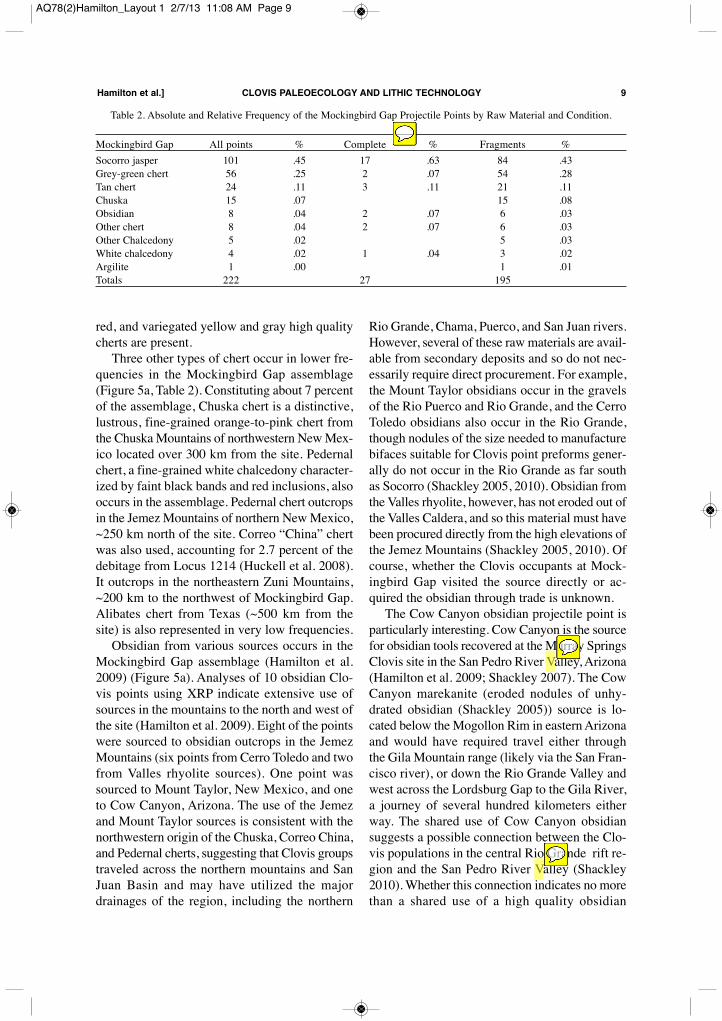
red, and variegated yellow and gray high qualitycherts are present.Three other types of chert occur in lower fre-
quencies in the Mockingbird Gap assemblage(Figure 5a, Table 2). Constituting about 7 percentof the assemblage, Chuska chert is a distinctive,lustrous, fine-grained orange-to-pink chert fromthe Chuska Mountains of northwestern New Mex-ico located over 300 km from the site. Pedernalchert, a fine-grained white chalcedony character-ized by faint black bands and red inclusions, alsooccurs in the assemblage. Pedernal chert outcropsin the Jemez Mountains of northern New Mexico,~250 km north of the site. Correo “China” chertwas also used, accounting for 2.7 percent of thedebitage from Locus 1214 (Huckell et al. 2008).It outcrops in the northeastern Zuni Mountains,~200 km to the northwest of Mockingbird Gap.Alibates chert from Texas (~500 km from thesite) is also represented in very low frequencies.Obsidian from various sources occurs in the
Mockingbird Gap assemblage (Hamilton et al.2009) (Figure 5a). Analyses of 10 obsidian Clo-vis points using XRP indicate extensive use ofsources in the mountains to the north and west ofthe site (Hamilton et al. 2009). Eight of the pointswere sourced to obsidian outcrops in the JemezMountains (six points from Cerro Toledo and twofrom Valles rhyolite sources). One point wassourced to Mount Taylor, New Mexico, and oneto Cow Canyon, Arizona. The use of the Jemezand Mount Taylor sources is consistent with thenorthwestern origin of the Chuska, Correo China,and Pedernal cherts, suggesting that Clovis groupstraveled across the northern mountains and SanJuan Basin and may have utilized the majordrainages of the region, including the northern
Rio Grande, Chama, Puerco, and San Juan rivers.However, several of these raw materials are avail-able from secondary deposits and so do not nec-essarily require direct procurement. For example,the Mount Taylor obsidians occur in the gravelsof the Rio Puerco and Rio Grande, and the CerroToledo obsidians also occur in the Rio Grande,though nodules of the size needed to manufacturebifaces suitable for Clovis point preforms gener-ally do not occur in the Rio Grande as far southas Socorro (Shackley 2005, 2010). Obsidian fromthe Valles rhyolite, however, has not eroded out ofthe Valles Caldera, and so this material must havebeen procured directly from the high elevations ofthe Jemez Mountains (Shackley 2005, 2010). Ofcourse, whether the Clovis occupants at Mock-ingbird Gap visited the source directly or ac-quired the obsidian through trade is unknown.The Cow Canyon obsidian projectile point is
particularly interesting. Cow Canyon is the sourcefor obsidian tools recovered at the Murray SpringsClovis site in the San Pedro River Valley, Arizona(Hamilton et al. 2009; Shackley 2007). The CowCanyon marekanite (eroded nodules of unhy-drated obsidian (Shackley 2005)) source is lo-cated below the Mogollon Rim in eastern Arizonaand would have required travel either throughthe Gila Mountain range (likely via the San Fran-cisco river), or down the Rio Grande Valley andwest across the Lordsburg Gap to the Gila River,a journey of several hundred kilometers eitherway. The shared use of Cow Canyon obsidiansuggests a possible connection between the Clo-vis populations in the central Rio Grande rift re-gion and the San Pedro River Valley (Shackley2010). Whether this connection indicates no morethan a shared use of a high quality obsidian
Hamilton et al.] CLOVIS PALEOECOLOGY AND LITHIC TECHNOLOGY 9
Table 2. Absolute and Relative Frequency of the Mockingbird Gap Projectile Points by Raw Material and Condition.
Mockingbird Gap All points % Complete % Fragments %Socorro jasper 101 .45 17 .63 84 .43Grey-green chert 56 .25 2 .07 54 .28Tan chert 24 .11 3 .11 21 .11Chuska 15 .07 15 .08Obsidian 8 .04 2 .07 6 .03Other chert 8 .04 2 .07 6 .03Other Chalcedony 5 .02 5 .03White chalcedony 4 .02 1 .04 3 .02Argilite 1 .00 1 .01Totals 222 27 195
AQ78(2)Hamilton_Layout 1 2/7/13 11:08 AM Page 9
source, or direct trading, is unknown. Interest-ingly, however, the utilization of the Cow Canyonsource would have required detailed knowledgeof the Mogollon Rim country and considerabletime and effort to make the journey.Lithic Raw Material Selection in the Central
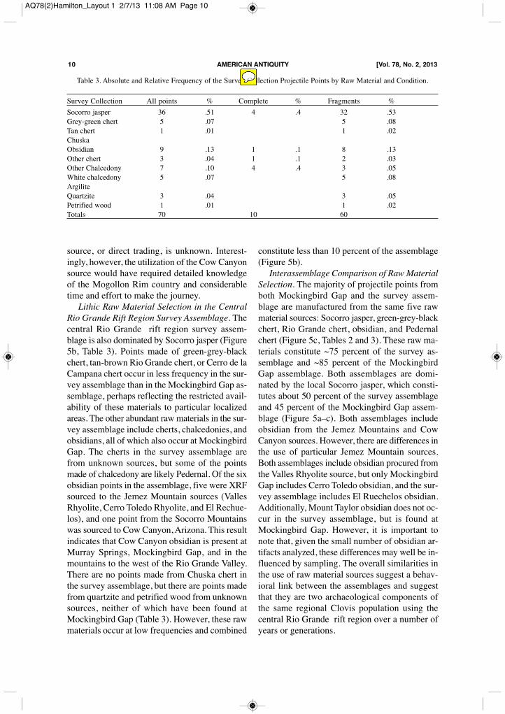
Rio Grande Rift Region Survey Assemblage. Thecentral Rio Grande rift region survey assem-blage is also dominated by Socorro jasper (Figure5b, Table 3). Points made of green-grey-blackchert, tan-brown Rio Grande chert, or Cerro de laCampana chert occur in less frequency in the sur-vey assemblage than in the Mockingbird Gap as-semblage, perhaps reflecting the restricted avail-ability of these materials to particular localizedareas. The other abundant raw materials in the sur-vey assemblage include cherts, chalcedonies, andobsidians, all of which also occur at MockingbirdGap. The cherts in the survey assemblage arefrom unknown sources, but some of the pointsmade of chalcedony are likely Pedernal. Of the sixobsidian points in the assemblage, five were XRFsourced to the Jemez Mountain sources (VallesRhyolite, Cerro Toledo Rhyolite, and El Rechue-los), and one point from the Socorro Mountainswas sourced to Cow Canyon, Arizona. This resultindicates that Cow Canyon obsidian is present atMurray Springs, Mockingbird Gap, and in themountains to the west of the Rio Grande Valley.There are no points made from Chuska chert inthe survey assemblage, but there are points madefrom quartzite and petrified wood from unknownsources, neither of which have been found atMockingbird Gap (Table 3). However, these rawmaterials occur at low frequencies and combined
constitute less than 10 percent of the assemblage(Figure 5b).Interassemblage Comparison of Raw Material
Selection. The majority of projectile points fromboth Mockingbird Gap and the survey assem-blage are manufactured from the same five rawmaterial sources: Socorro jasper, green-grey-blackchert, Rio Grande chert, obsidian, and Pedernalchert (Figure 5c, Tables 2 and 3). These raw ma-terials constitute ~75 percent of the survey as-semblage and ~85 percent of the MockingbirdGap assemblage. Both assemblages are domi-nated by the local Socorro jasper, which consti-tutes about 50 percent of the survey assemblageand 45 percent of the Mockingbird Gap assem-blage (Figure 5a–c). Both assemblages includeobsidian from the Jemez Mountains and CowCanyon sources. However, there are differences inthe use of particular Jemez Mountain sources.Both assemblages include obsidian procured fromthe Valles Rhyolite source, but only MockingbirdGap includes Cerro Toledo obsidian, and the sur-vey assemblage includes El Ruechelos obsidian.Additionally, Mount Taylor obsidian does not oc-cur in the survey assemblage, but is found atMockingbird Gap. However, it is important tonote that, given the small number of obsidian ar-tifacts analyzed, these differences may well be in-fluenced by sampling. The overall similarities inthe use of raw material sources suggest a behav-ioral link between the assemblages and suggestthat they are two archaeological components ofthe same regional Clovis population using thecentral Rio Grande rift region over a number ofyears or generations.
10 AMERICAN ANTIQUITY [Vol. 78, No. 2, 2013
Table 3. Absolute and Relative Frequency of the Survey Collection Projectile Points by Raw Material and Condition.
Survey Collection All points % Complete % Fragments %Socorro jasper 36 .51 4 .4 32 .53Grey-green chert 5 .07 5 .08Tan chert 1 .01 1 .02ChuskaObsidian 9 .13 1 .1 8 .13Other chert 3 .04 1 .1 2 .03Other Chalcedony 7 .10 4 .4 3 .05White chalcedony 5 .07 5 .08ArgiliteQuartzite 3 .04 3 .05Petrified wood 1 .01 1 .02Totals 70 10 60
AQ78(2)Hamilton_Layout 1 2/7/13 11:08 AM Page 10
Point Morphology of the Central Rio GrandeRift Region Clovis Projectile Points. Basal pointfragments make up the majority of the Mocking-bird Gap assemblage (Table 1), consistent withcampsite retooling activities such as the discard,manufacture, and replacement of broken points.The shape of the basal concavities in the Mock-ingbird Gap assemblage varies widely, rangingfrom flat to varying degrees of concavity to tri-angular. Analysis of variance shows that shape ofthe base is not related to raw material type, as nei-ther basal width, measured by the distance be-tween the two basal ears (F = 1.47, df = 9, 92, p= .17), nor the depth of basal concavity, mea-sured by the difference between overall and mid-line lengths (F = .90, df = 8, 80, p = .52), variesconsistently with raw material type. This sug-gests that much of the variation in basal formlikely results from manufacturing decisions orcultural traditions, rather than mechanical con-straints imposed by the properties of the individ-ual raw materials. Fluting characteristics vary inthe collection from single to multiple flutes.Projectile points in the survey assemblage are
of the same general morphology as the standard-sized Clovis points from Mockingbird Gap, andalthough they display a high degree of variationin form, in general, points are parallel-sided witha similar range of variation in basal concavities asthose found at Mockingbird Gap. There are nominiature points in the survey assemblage, thoughthis might be due to size-based identification andcollection bias. Similar to the Mockingbird Gappoints, neither basal width (F = 2.59, df = 5, 24,p = .05) nor depth of basal concavity (F = 2.24,df = 7, 33, p > .05) varies with raw material typein the survey sample. The two largest Clovispoints from the survey assemblage were recov-ered immediately to the west of Socorro (Figure2d). One is a heavily reworked point and theother is a complete point, both manufactured ofchert or agate from unknown sources. The agatepoint in particular is consistent with the size andcraftsmanship of some of the larger points foundin Clovis caches throughout the western UnitedStates (Kilby 2008). Unfortunately, this speci-men was recovered in a secondary alluvial depositof Holocene age, and no other Clovis artifactswere recovered from the immediate area (R. H.Weber, personal communication, 2007).
Analysis 2: Point Size DistributionsFor the quantitative comparison of the assem-blages, we now turn to the statistical analysis ofpoint size distributions.Mockingbird Gap Point Character Distribu-
tions. Figure 6a shows the point area distributionfor all 25 complete points from Mockingbird Gap.The distribution is unimodal and lognormal, aswould be expected for culturally transmitted tech-nologies (Hamilton and Buchanan 2009). How-ever, the same data plotted by basal width, ratherthan overall size, reveal a different pattern. Figure6b shows that the distribution of basal widths ofcomplete points is truncated at about 2 cm, withthe body of the distribution resembling the lowertail of a normal distribution. A plot of all basalwidths from Mockingbird Gap shows a morestandard unimodal distribution, though slightlyleft skewed (Figure 6b). The peak in the distrib-ution of all basal widths matches the truncation ofthe complete points, suggesting that while the to-tal assemblage of points used, manufactured, anddiscarded at Mockingbird Gap is normally dis-tributed, the sample of complete points is heavilybiased toward small points. We suggest that thismay reflect the reuse and reworking of heavilyused and broken points at Mockingbird Gap, con-sistent with the impression that the site was re-peatedly occupied over a substantial length oftime. In general, the distributions in Figure 6bsuggest that all broken points with a basal widthgreater than ~2 cm were systematically collectedand reworked into new points and tools, whereasall broken points below that threshold were dis-carded and left at the site, presumably becausethey were regarded as too small to be reused.Central Rio Grande Rift Region Survey Point
Character Distributions. Figure 6c shows thebasal width distributions for the complete pointsfrom the survey assemblage (n = 8) and all com-plete bases (n = 32). Although the sample size ofcomplete points is very small, the distribution ofcomplete points and all bases is similar in shape,and both are skewed to the right. Note also thatthere is only one complete point and two completebases less than 2 cm wide, suggesting that, on av-erage, the points from the survey collection arelarger than at Mockingbird Gap. However, plot-ting both distributions on the same figure (Figure6d) is revealing. These distributions suggest that
Hamilton et al.] CLOVIS PALEOECOLOGY AND LITHIC TECHNOLOGY 11
AQ78(2)Hamilton_Layout 1 2/7/13 11:08 AM Page 11
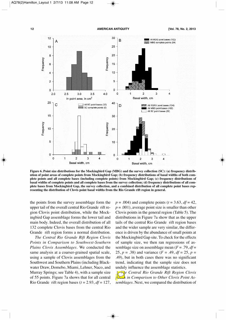
the points from the survey assemblage form theupper tail of the overall central Rio Grande rift re-gion Clovis point distribution, while the Mock-ingbird Gap assemblage forms the lower tail andmain body. Indeed, the overall distribution of all132 complete Clovis bases from the central RioGrande rift region forms a normal distribution.The Central Rio Grande Rift Region Clovis
Points in Comparison to Southwest-SouthernPlains Clovis Assemblages. We conducted thesame analysis at a coarser-grained spatial scale,using a sample of Clovis assemblages from theSouthwest and Southern Plains (including Black-water Draw, Domebo, Miami, Lehner, Naco, andMurray Springs; see Table 4), with a sample sizeof 55 points. Figure 7a shows that for all centralRio Grande rift region bases (t = 2.93, df = 127,
p = .004) and complete points (t = 3.63, df = 42,p = .001), average point size is smaller than otherClovis points in the general region (Table 5). Thedistributions in Figure 7a show that as the uppertails of the central Rio Grande rift region basesand the wider sample are very similar, the differ-ence is driven by the abundance of small points atthe Mockingbird Gap site. To check for the effectsof sample size, we then ran regressions of as-semblage size on assemblage mean (F = .79, df =25, p = .38) and variance (F = .49, df = 25, p =.49), but in both cases there was no significanttrend, indicating that the sample size does notunduly influence the assemblage statistics. The Central Rio Grande Rift Region Clovis
points in Comparison to Other Clovis Point As-semblages. Next, we compared the distribution of
12 AMERICAN ANTIQUITY [Vol. 78, No. 2, 2013
Figure 6. Point size distributions for the Mockingbird Gap (MBG) and the survey collection (SC): (a) frequency distrib-ution of point areas of complete points from Mockingbird Gap; (b) frequency distributions of basal widths of both com-plete points and all complete bases (including complete points) from Mockingbird Gap; (c) frequency distributions ofbasal widths of complete points and all complete bases from the survey collection; (d) frequency distributions of all com-plete bases from Mockingbird Gap, the survey collection, and a combined distribution of all complete point bases rep-resenting the distribution of Clovis point basal widths from the Rio Grande rift region in general.
AQ78(2)Hamilton_Layout 1 2/7/13 11:08 AM Page 12
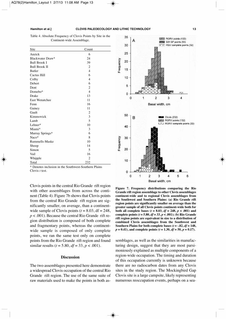
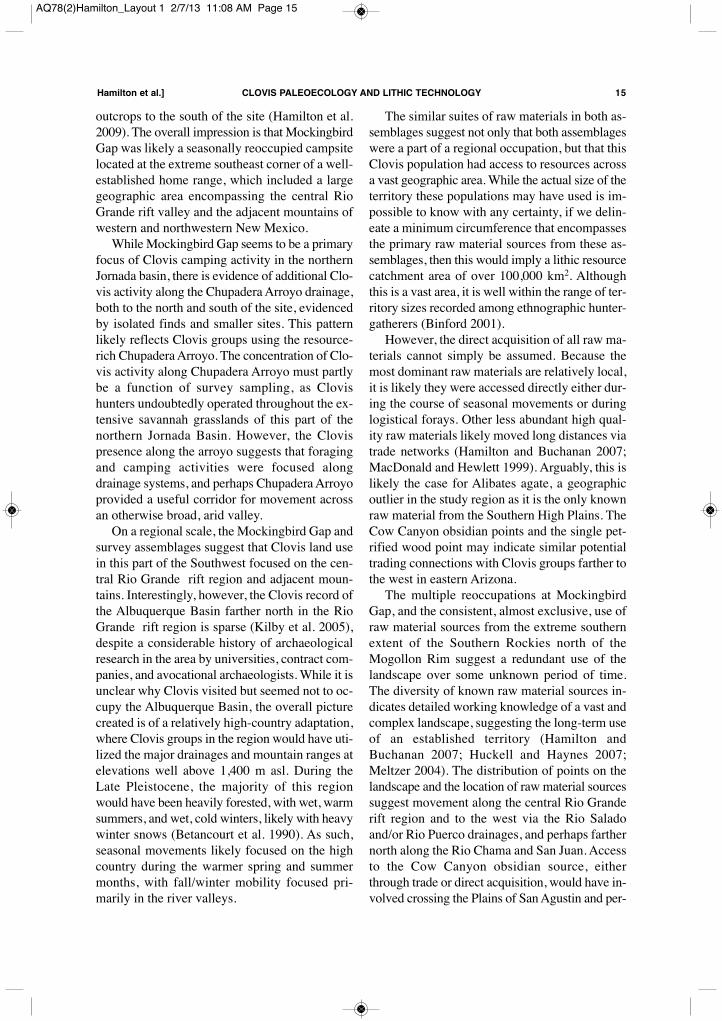
Clovis points in the central Rio Grande rift regionwith other assemblages from across the conti-nent (Table 4). Figure 7b shows that Clovis pointsfrom the central Rio Grande rift region are sig-nificantly smaller, on average, than a continent-wide sample of Clovis points (t = 8.03, df = 248,p < .001). Because the central Rio Grande rift re-gion distribution is composed of both completeand fragmentary points, whereas the continent-wide sample is composed of only completepoints, we ran the same test only on completepoints from the Rio Grande rift region and foundsimilar results (t = 5.80, df = 33, p < .001).
DiscussionThe two assemblages presented here demonstratea widespread Clovis occupation of the central RioGrande rift region. The use of the same suite ofraw materials used to make the points in both as-
semblages, as well as the similarities in manufac-turing design, suggest that they are most parsi-moniously explained as multiple components of aregion-wide occupation. The timing and durationof this occupation currently is unknown becausethere are no radiocarbon dates from any Clovissites in the study region. The Mockingbird GapClovis site is a large campsite, likely representingnumerous reoccupation events, perhaps on a sea-
Hamilton et al.] CLOVIS PALEOECOLOGY AND LITHIC TECHNOLOGY 13
Table 4. Absolute Frequency of Clovis Points by Site in theContinent-wide Assemblage.
Site CountAnzick 6Blackwater Draw* 24Bull Brook I 39Bull Brook II 2Butler 4Cactus Hill 6Colby 4Debert 6Dent 2Domebo* 4Drake 13East Wenatchee 11Fenn 16Gainey 11Gault 2Kimmswick 3Lamb 5Lehner* 10Miami* 3Murray Springs* 6Naco* 8Rummells-Maske 10Shoop 14Simon 5Vail 16Whipple 2Total 232* Denotes inclusion in the Southwest-Southern PlainsClovis t test.
Figure 7. Frequency distributions comparing the RioGrande rift region assemblage to other Clovis assemblagescontinent-wide and to regional Clovis assemblages fromthe Southwest and Southern Plains: (a) Rio Grande riftregion points are significantly smaller on average than thegreater sample of all Clovis points continent-wide both forboth all complete bases (t = 8.03, df = 248, p < .001) andcomplete points (t = 5.80, df = 33, p < .001); (b) Rio Granderift region points are equivalent in size to a distribution ofcombined Clovis assemblages from the Southwest andSouthern Plains for both complete bases (t = -.82, df = 148,p = 0.41), and complete points (t = 1.30, df = 50, p = 0.17).
AQ78(2)Hamilton_Layout 1 2/7/13 11:08 AM Page 13
sonal or annual basis. The survey assemblage isthe archeological residue of a more diffuse occu-pation of the region, including temporary campsand isolated finds, again probably indicating sea-sonal mobility and access to a variety of highquality raw material sources for stone tool manu-facture over a wide region of the southeast Col-orado Plateau and southernmost Southern Rockies.Camp activities at Mockingbird Gap are sug-
gested by the overwhelming dominance of pro-jectile point bases, manufactured primarily fromlocally available raw materials, but also by themany preform fragments in the assemblage,which are consistent with weaponry manufactureand retooling tasks. In addition, the Locus 1214excavated assemblage includes many lithic arti-facts indicative of projectile point manufacture,including biface fragments, biface reductionflakes, and the termination of a large overshotflake, in addition to two Clovis projectile pointbases (Huckell et al. 2006; Huckell et al. 2007;Huckell et al. 2008). The miniature points from Mockingbird Gap
are morphologically and technologically distinctfrom the standard-sized Clovis points at the siteand vary widely in manufacturing quality, rangingfrom flakes that have been crudely shaped tomimic the shape of Clovis points to others thatwere clearly manufactured by accomplishedflintknappers. While flake-based miniature pointsare not abundant in Clovis assemblages, they dooccur with some frequency in Folsom contexts,where they are generally termed “pseudo-flutedpoints” (Wilmsen and Roberts 1978). How theseminiature points functioned is unknown. While
several of the miniature points are crudely workedflakes that were shaped into the approximate formof Clovis points, perhaps indicating manufactureby children, others were apparently manufacturedby skilled flintknappers, perhaps indicating thatthey were manufactured by parents for their off-spring. The fact that miniature points occur withsuch high relative frequency at the MockingbirdGap site is a function both of the large sample sizeof projectile points from the site and of the in-tensive survey and monitoring of the site by R. H.Weber. Despite the large sample size and diversity of
projectile point sizes at Mockingbird Gap, thesuite of raw materials evidenced in the projectilepoint collection indicates a relatively focused useof source locations in the mountains to the northand west of the site. Indeed, there is a conspicu-ous paucity of known high quality raw materialsfrom the east, particularly Edwards chert and Al-ibates agate. Other high quality raw materialsources in the Jornada del Muerto, such asRancheria chert (Amick 1996), are also absentfrom the Mockingbird Gap assemblage, despite itsrelative proximity. There are Clovis artifacts madefrom Rancheria chert in the region (Daniel Amick,personal communication, 2007), and so presum-ably the chert could have been obtained througheither direct acquisition or trade. Of course,whether the Clovis occupation of the southernJornada Basin was contemporary with the occu-pation in the northern Basin is unknown. Simi-larly, despite the significant presence of obsidianfrom sources throughout western New Mexico,there are no artifacts sourced to known obsidian
14 AMERICAN ANTIQUITY [Vol. 78, No. 2, 2013
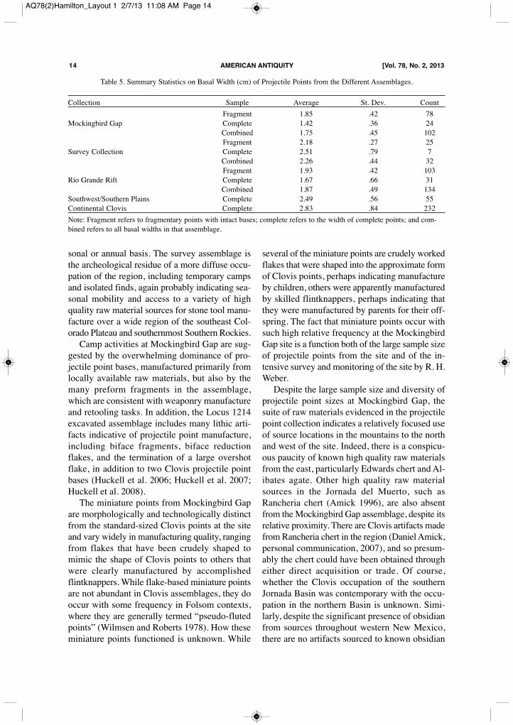
Table 5. Summary Statistics on Basal Width (cm) of Projectile Points from the Different Assemblages.
Collection Sample Average St. Dev. CountFragment 1.85 .42 78
Mockingbird Gap Complete 1.42 .36 24Combined 1.75 .45 102Fragment 2.18 .27 25
Survey Collection Complete 2.51 .79 7Combined 2.26 .44 32Fragment 1.93 .42 103
Rio Grande Rift Complete 1.67 .66 31Combined 1.87 .49 134
Southwest/Southern Plains Complete 2.49 .56 55Continental Clovis Complete 2.83 .84 232Note: Fragment refers to fragmentary points with intact bases; complete refers to the width of complete points; and com-bined refers to all basal widths in that assemblage.
AQ78(2)Hamilton_Layout 1 2/7/13 11:08 AM Page 14
outcrops to the south of the site (Hamilton et al.2009). The overall impression is that MockingbirdGap was likely a seasonally reoccupied campsitelocated at the extreme southeast corner of a well-established home range, which included a largegeographic area encompassing the central RioGrande rift valley and the adjacent mountains ofwestern and northwestern New Mexico.While Mockingbird Gap seems to be a primary
focus of Clovis camping activity in the northernJornada basin, there is evidence of additional Clo-vis activity along the Chupadera Arroyo drainage,both to the north and south of the site, evidencedby isolated finds and smaller sites. This patternlikely reflects Clovis groups using the resource-rich Chupadera Arroyo. The concentration of Clo-vis activity along Chupadera Arroyo must partlybe a function of survey sampling, as Clovishunters undoubtedly operated throughout the ex-tensive savannah grasslands of this part of thenorthern Jornada Basin. However, the Clovispresence along the arroyo suggests that foragingand camping activities were focused alongdrainage systems, and perhaps Chupadera Arroyoprovided a useful corridor for movement acrossan otherwise broad, arid valley.On a regional scale, the Mockingbird Gap and
survey assemblages suggest that Clovis land usein this part of the Southwest focused on the cen-tral Rio Grande rift region and adjacent moun-tains. Interestingly, however, the Clovis record ofthe Albuquerque Basin farther north in the RioGrande rift region is sparse (Kilby et al. 2005),despite a considerable history of archaeologicalresearch in the area by universities, contract com-panies, and avocational archaeologists. While it isunclear why Clovis visited but seemed not to oc-cupy the Albuquerque Basin, the overall picturecreated is of a relatively high-country adaptation,where Clovis groups in the region would have uti-lized the major drainages and mountain ranges atelevations well above 1,400 m asl. During theLate Pleistocene, the majority of this regionwould have been heavily forested, with wet, warmsummers, and wet, cold winters, likely with heavywinter snows (Betancourt et al. 1990). As such,seasonal movements likely focused on the highcountry during the warmer spring and summermonths, with fall/winter mobility focused pri-marily in the river valleys.
The similar suites of raw materials in both as-semblages suggest not only that both assemblageswere a part of a regional occupation, but that thisClovis population had access to resources acrossa vast geographic area. While the actual size of theterritory these populations may have used is im-possible to know with any certainty, if we delin-eate a minimum circumference that encompassesthe primary raw material sources from these as-semblages, then this would imply a lithic resourcecatchment area of over 100,000 km2. Althoughthis is a vast area, it is well within the range of ter-ritory sizes recorded among ethnographic hunter-gatherers (Binford 2001). However, the direct acquisition of all raw ma-
terials cannot simply be assumed. Because themost dominant raw materials are relatively local,it is likely they were accessed directly either dur-ing the course of seasonal movements or duringlogistical forays. Other less abundant high qual-ity raw materials likely moved long distances viatrade networks (Hamilton and Buchanan 2007;MacDonald and Hewlett 1999). Arguably, this islikely the case for Alibates agate, a geographicoutlier in the study region as it is the only knownraw material from the Southern High Plains. TheCow Canyon obsidian points and the single pet-rified wood point may indicate similar potentialtrading connections with Clovis groups farther tothe west in eastern Arizona.The multiple reoccupations at Mockingbird
Gap, and the consistent, almost exclusive, use ofraw material sources from the extreme southernextent of the Southern Rockies north of theMogollon Rim suggest a redundant use of thelandscape over some unknown period of time.The diversity of known raw material sources in-dicates detailed working knowledge of a vast andcomplex landscape, suggesting the long-term useof an established territory (Hamilton andBuchanan 2007; Huckell and Haynes 2007;Meltzer 2004). The distribution of points on thelandscape and the location of raw material sourcessuggest movement along the central Rio Granderift region and to the west via the Rio Saladoand/or Rio Puerco drainages, and perhaps farthernorth along the Rio Chama and San Juan. Accessto the Cow Canyon obsidian source, eitherthrough trade or direct acquisition, would have in-volved crossing the Plains of San Agustin and per-
Hamilton et al.] CLOVIS PALEOECOLOGY AND LITHIC TECHNOLOGY 15
AQ78(2)Hamilton_Layout 1 2/7/13 11:08 AM Page 15
haps traveling along the San Francisco River to-ward the Mogollon Rim, a route likely viableduring only the summer.The wider regional pattern of land-use across
the greater Southwest and northern Mexico thatseems to be emerging is one of relatively localizedhotspots of activity connected by the shared useof raw materials, separated by regions of lowdensity Clovis occupation. Such hotspots in thesouthwest region would include the central RioGrande rift region, the San Pedro River Valley,and western Sonora. This pattern of land usewould be more consistent with models that sug-gest that Clovis populations established territoriesin favorable ecological contexts across the conti-nent, bypassing less favorable regions (i.e. An-derson and Gillam 2000; Hamilton and Buchanan2007; Meltzer 2004), rather than models that sug-gest a more ephemeral, non-redundant, sweepinguse of the landscape (i.e. Kelly and Todd 1988;Martin 1967). Of course, the visibility of suchhotspots is partly the result of survey and re-search sampling bias, as well as issues of preser-vation and deposition (Buchanan 2003; Prasciu-nas 2011). However, the primary centers of Clovisactivity in the southwestern U.S. and northernMexico are not directly associated with majorpopulation centers or areas of agriculture, unlikeother regions across the continent (Buchanan2003), which suggests that we may be starting tosee the true spatial signal of the Clovis settlementpattern in this region.
ConclusionThe Clovis archaeological record of the centralRio Grande rift region suggests that Clovis pop-ulations utilized a large and well-known territorycovering much of northern and western NewMexico. The archaeological record at Mocking-bird Gap indicates extensive and, most likely, re-peated occupations over an unknown period oftime, and the consistent use of the same suite ofhigh quality lithic raw materials from sourcesdispersed across this vast region suggests an inti-mate familiarity with this varied landscape. Assuch, the Clovis archaeology of this region indi-cates a high-elevation adaptation, between ~1500m asl and ~4,000 m asl, which included both thesavannah grasslands of the central Rio Grande rift
valley and the woodlands and forests of the adja-cent mountains. The ecological setting of the Mockingbird Gap
site is similar to other Clovis sites in the greaterSouthwest, such as Lubbock Lake and Blackwa-ter Draw. Similarly, the lithic technology utilizedby Clovis peoples in the region is consistent withother Clovis assemblages across the greaterSouthwest and across North America in general. Acknowledgments. We dedicate this paper to the memory ofDr. Robert H. Weber, without whose dedication to recordingthe archaeology of the central Rio Grande Valley for more thanhalf a century, the above research would not have been pos-sible. The archaeological information he gathered over his life-time and donated to the State of New Mexico will be a keysource for future generations of archaeologists working in alltime periods of the central Rio Grande Valley. The senior au-thor was funded by the National Science Foundation and theRockefeller Foundation. The 2005–2006 excavations at Mock-ingbird Gap were supported by the Argonaut ArchaeologicalResearch Fund (to Vance Holliday; University of Arizona(UA) Foundation) and the Maxwell Museum of Anthropology.University of New Mexico (UNM) supported the 2007 fieldschool at Locus 1214. The XRF analysis of the obsidian arti-facts was funded by NSF Archaeometry Competition grantsBCS-0716333, and BCS-0905411 to Steve Shackley. We arealso greatly indebted to the New Mexico State Land Office(David Eck), New Mexico Historic Preservation Division(for permits), the 2007 UNM field school students, UNM/UAgraduate student volunteers for the 2005–2006 excavations,Lori Washbon and Catherine Baudoin for Photoshop work onthe projectile point figure, and Socorro Springs and the Capi-tol Bar, Socorro.
References CitedAllen, Bruce D.2005 Ice-Age Lakes in New Mexico. In New Mexico’s IceAges, edited by S. G. Lucas, G. S. Morgan and S. E. Zei-gler, pp. 107–114. Bulletin 28. New Mexico Museum ofNatural History and Science, Albuquerque.
Allen, Bruce D., and Ron Y. Anderson2000 A Continuous, High-Resolution Record of Late Pleis-tocene Climate Variability from the Estancia Basin, NewMexico. Geological Society of America Bulletin112:1444–1458.
Amick, Daniel S.1996 Regional Patterns of Folsom Mobility and Land Usein the American Southwest. World Archaeology 27:411–426.
Anderson, David G., and J. Christopher Gillam2000 Paleoindian Colonization of the Americas: Implicationsfrom an Examination of Physiography, Demography, andArtifact Distribution. American Antiquity 65:43–66.
Anderson, Ron Y., Bruce D. Allen, and Kristen M. Menking2002 Geomorphic Expression of Abrupt Climate Change inSouthwestern North America at the Glacial Termination.Quaternary Research 57:371–381.
Betancourt, Julio L., Thomas R. Van Devender, and Paul S. Mar-tin (editors)
16 AMERICAN ANTIQUITY [Vol. 78, No. 2, 2013
AQ78(2)Hamilton_Layout 1 2/7/13 11:08 AM Page 16

1990 Packrat Middens: The Last 40,000 Years of BioticChange. University of Arizona Press, Tucson.
Binford, Lewis R.2001 Constructing Frames of Reference: An AnalyticalMethod for Archaeological Theory Building Using Ethno-graphic and Environmental Data Sets.University of Cal-ifornia Press, Berkeley.
Boldurian, Anthony T., and John L. Cotter1999 Clovis Revisited: New Perspectives on PaleoindianAdaptations from Blackwater Draw, New Mexico. UniversityMuseum, University of Pennsylvania, Philadelphia.
Buchanan, Briggs2003 The Effects of Sample Bias on Paleoindian Fluted PointRecovery in the United States. North American Archae-ologist 24:311–338.
2005 Cultural Transmission and Stone Tools: A Study of Ear-ly Paleoindian Technology in North America. Ph.D. dis-sertation, Department of Anthropology, University ofNew Mexico, Albuquerque.
Buchanan, Briggs, and Mark Collard 2007 Investigating the Peopling of North America throughCladistic Analyses of Early Paleoindian Projectile Points.Journal of Anthropological Archaeology 26:366–393.
Buchanan, Briggs, and Marcus J. Hamilton 2009 A Formal Test of the Origin of Variation in North Amer-ican Early Paleoindian Points. American Antiquity74:279–299.
Chamberlin, Richard M., and Ted. L. Eggleston1999 Geological Map of the Luis Lopez 7.5 Minute Quad-rangle, Socorro County, New Mexico. New Mexico Bureauof Mines and Mineral Resources.
Dello-Russo, Robert D.2004 Geochemical Comparisons of Silicified Rhyolites fromTwo Prehistoric Quarries and 11 Prehistoric Projectile Points,Socorro County, New Mexico, U.S.A. Geoarchaeology19:237–264.
Gaines, Edmund P., Guadalupe Sanchez, and Vance T. Holliday2009 Paleoindian Archaeology in Northern and Central Sono-ra, Mexico. Kiva 74:305–335.
Hamilton, Marcus J.2008 Quantifying Clovis Dynamics: Confronting Theory withModels and Data across Scales. Ph.D. Dissertation, De-partment of Anthropology, University of New Mexico, Al-buquerque.
Hamilton, Marcus J., and Briggs Buchanan2007 Spatial Gradients in Clovis-Age Radiocarbon DatesAcross North America Suggest Rapid Colonization fromthe North. Proceedings of the National Academy of Sciences104:15629–15634.
2009 The Accumulation of Stochastic Copying ErrorsCauses Drift in Culturally Transmitted Technologies:Quantifying Clovis Evolutionary Dynamics. Journal of An-thropological Archaeology 28:55–69.
Hamilton, Marcus J., Bruce B. Huckell, and M. Steven Shackley2009 Clovis Obsidian Sources in the Central Rio Grande RiftRegion, New Mexico. Current Research in the Pleistocene26:62–65.
Haury, Emil W.1953 Artifacts with Mammoth Remains, Naco, Arizona.American Antiquity 19:1–24.
Haury, Emil W., E. B. Sayles, and William W. Wasley1959 The Lehner Mammoth Site, Southeastern Arizona.American Antiquity 25:2–30.
Hawley, John W.2005 Five Million Years of Landscape Evolution in NewMexico: An Overview Based on Two Centuries of Geo-
morphic Conceptual-Model Development. In New Mexi-co’s Ice Ages, edited by S. G. Lucas, G. S. Morgan and K.E. Zeigler, pp. 9–94. Bulletin 28. New Mexico Museum ofNatural History and Science, Albuquerque.
Haynes, C. Vance, and Bruce B. Huckell (editors)2007 Murray Springs: A Clovis Site with Multiple ActivityAreas in the San Pedro Valley, Arizona. University of Ari-zona, Tucson.
Hemmings, E. Thomas, and C. Vance Haynes1969 The Escapule Mammoth and Associated ProjectilePoints in the San Pedro Valley, Arizona. Journal of the Ari-zona Academy of Science 5:184–188.
Hester, James J.1972 Blackwater Draw Locality No. 1: A Stratified EarlyMan Site in Eastern New Mexico 8. Fort Burgwin ResearchCenter, Ranchos de Taos.
Holliday, Vance T.1997 Paleoindian Geoarchaeology of the Southern HighPlains. University of Texas Press, Austin.
Holliday, Vance T., C. Vance Haynes, Jack L. Hofman, and DavidJ. Meltzer
1994 Geoarchaeology and Geochronology of the Miami (Clo-vis) site, Southern High Plains of Texas. Quaternary Re-search 41:234–244.
Holliday, Vance T., Bruce B. Huckell, Robert H. Weber, Mar-cus J. Hamilton, William R. Reitze, and James H. Mayer
2009 Geoarchaeology of the Mockingbird Gap (Clovis) Site,Jornada del Muerto, New Mexico. Geoarchaeology24:348–370.
Holmgren, Camille A., Julio L. Betancourt, and Kate A. Rylander2006 A 36,000-yr Vegetation History of the Peloncillo Moun-tains, Southeastern Arizona, USA. PalaeogeographyPalaeoclimatology Palaeoecology 240:405–422.
Holmgren, C. A., Jodi Norris, and Julio L. Betancourt2007 Inferences about Winter Temperatures and SummerRains from the Late Quaternary Record of C4 PerennialGrasses and C3 Desert Shrubs in the Northern ChihuahuanDesert. Journal of Quaternary Research 22:141–161.
Holmgren, Camille A., M. Cristina Pinalba, Kate A. Rylander,and Julio L. Betancourt
2003 A 16,000 14C yr B.P. Packrat Midden Series from theUSA-Mexico Borderlands. Quaternary Research60:319–329.
Huckell, Bruce B., and C. Vance Haynes2007 Clovis Paleoecology as Viewed from Murray Springs,Arizona. In Murray Springs, A Clovis Site with Multiple Ac-tivity Areas in the San Pedro Valley, Arizona., edited by C.Vance Haynes and Bruce B. Huckell, pp. 214–225. An-thropological Papers of the University of Arizona, Vol. 71.University of Arizona Press, Tucson.
Huckell, Bruce B., Vance T. Holliday, Marcus J. Hamilton, Christi-na Sinkovec, Chric Merriman, M. Steven Shackley, andRobert H. Weber
2008 The Mockingbird Gap Clovis Site: The 2007 Season.Current Research in the Pleistocene 25:95–97.
Huckell, Bruce B., Vance T. Holliday, and Robert H. Weber2007 Test Excavations at the Mockingbird Gap Clovis site:Results of the 2006 Field Season. Current Research in thePleistocene 24:102–104.
Huckell, Bruce B., Vance T. Holliday, Robert H. Weber, and JamesH. Mayer
2006 Archaeological and Geological Test Investigations atthe Mockingbird Gap Clovis Site, Central New Mexico.Current Research in the Pleistocene 23:115–116.
Johnson, Eileen (editor)1987 Lubbock Lake: Late Quaternary Studies on theSouthern High Plains. Texas A&M University Press, Col-
Hamilton et al.] CLOVIS PALEOECOLOGY AND LITHIC TECHNOLOGY 17
AQ78(2)Hamilton_Layout 1 2/7/13 11:08 AM Page 17
lege Station.Judge, W. James1973 Paleoindian Occupation of the Central Rio Grande Val-ley in New Mexico. University of New Mexico Press, Al-buquerque.
Kelly, Robert L., and Lawrence C. Todd1988 Coming into the Country: Early Paleoindian Huntingand Mobility. American Antiquity 53:231–244.
Kilby, J. David2008 An Investigation of Clovis Caches: Content, Function,and Technological Organization. Ph.D. dissertation, De-partment of Anthropology, University of New Mexico, Al-buquerque.
Kilby, J. David, James Gallison, Roberto Herrera, DavidWilcox, and Valerie Renner
2005 Demolition Road: A New Clovis Site in the Middle RioGrande Valley of New Mexico. Current Research in thePleistocene 23:54–56.
Leonhardy, Frank C. (editor)1966 Domebo: A Paleo-Indian Mammoth Kill in thePrairie-Plains.Contributions of the Museum of the GreatPlains No. 1, Lawton, Oklahoma.
MacDonald, Douglas H., and Barry S. Hewlett1999 Reproductive Interests and Forager Mobility. CurrentAnthropology 40:501–523.
Martin, Paul S.1967 Prehistoric Overkill. In Pleistocene Extinctions: TheSearch for a Cause, edited by P. S. Martin and H. E.Wright, pp. 75–120. Yale University Press, New Haven.
Meltzer, David J.2004 Modeling the Initial Colonization of the Americas: Is-sues of Scale, Demography, and Landscape Learning. InThe Settlement of the American Continents, edited by C.Michael Barton, Geoffrey A. Clark, David A. Yesner andGeorges A. Pearson, pp. 123–137. University of ArizonaPress, Tucson.
Osburn, Glenn R., and Charles E. Chapin1983 Ash-Flow Tuffs and Cauldrons in the NortheastMogollon-Datil Volcanic Field: A Summary. In Socor-ro Region II, New Mexico Geological Society Guidebook,pp. 197–204. New Mexico Geological Society, Albu-querque.
Prasciunas, Mary M.2011 Mapping Clovis: Projectile Points, Behavior, and Bias.American Antiquity 76:107–126.
Reeves, C. C.1969 Pluvial Lake Palomas Northwestern Chihuahua, Mex-ico. In The Border Region: Chihuahua and the United States,edited by D. A. Cordoba, S. A. Wengerd and J. Shomaker,pp. 143–154. New Mexico Geological Society, Socorro.
Robles Ortiz, Manuel1974 Distribucion de Artifactos Clovis en Sonora. INAH Bo-letin 9:25–32.
Rohlf, F. James2004 tpsDIG, Digitize Landmarks and Outlines, Version 2.0.Department of Ecology and Evolution, State University ofNew York at Stony Brook. Electronic Document,http://life.bio.sunysb.edu/morph/index.html, accessed Feb-ruary 18, 2009.
Sánchez, M. Guadalupe2001 A Synopsis of Paleo-Indian Archaeology in Mexico.Kiva 67:119–136.
2010 Los Primos Mexicanos: Late Pleistocene/Early HoloceneArchaeology of Sonora, Mexico. Ph.D. dissertation, Schoolof Anthropology, University of Arizona, Tucson.
Sellards, E. H.1938 Artifacts Associated with Fossil Elephant. Bulletin ofthe Geological Society of America 49:999–1010.
Shackley, M. Steven2005 Obsidian: Geology and Archaeology in the North Amer-ican Southwest. University of Arizona Press, Tucson.
2007 Sources of Obsidian at the Murray Springs Clovis Site.In Murray Springs: A Clovis Site with Multiple Activity Ar-eas in the San Pedro Valley, Arizona, edited by C. VanceHaynes and Bruce B. Huckell, pp. 250–265. AnthropologicalPapers of the University of Arizona, Vol. 71. University ofArizona Press, Tucson.
2010 The Secondary Distribution of Archaeological Obsidianin the Rio Grande Quaternary Sediments, Jemez Mountainsto San Antonito, New Mexico: Inferences for PrehistoricProcurement and the Age of Sediments, 38th Internation-al Symposium on Archaeometry, Tampa, Florida. Poster pre-sentation.
Smith, Gary A.2004 Middle to Late Cenozoic Development of the RioGrande Rift and Adjacent Regions in Northern NewMexico. In The Geology of New Mexico: A Geologic His-tory, edited by G. H. Mack and K. A. Giles, pp. 331–358,Vol. 11. New Mexico Geologic Society Special Publica-tion, Socorro.
Strauss, Richard E., Momchil N. Atanassov, and Joao Alves deOliveira
2003 Evaluation of the Principal Component and Expecta-tion-Maximization Methods for Estimating Missing Datain Morphometric Studies. Journal of Vertebrate Paleon-tology 23:284–296.
Van Devender, Thomas R.1990 Late Quaternary Vegetation and Climate of the Chi-huahuan Desert, United States and Mexico. In Packrat Mid-dens: The Last 40,000 Years of Biotic Change, edited byJulio L. Betancourt, Thomas R. Van Devender and Paul S.Martin, pp. 104–133. University of Arizona Press, Tucson.
1995 Desert Grassland History: Changing Climates, Evo-lution, Biogeography, and Community Dynamics. In TheDesert Grassland, edited by Michael McClaran, P. andThomas R. Van Devender, pp. 68–99. University of Ari-zona Press, Tucson.
Weber, Robert H., and George A. Agogino1997 Mockingbird Gap Paleoindian Site: Exavations in 1967.In Layers of Time: Papers in Honor of Robert H. Weber,edited by M. S. Durhan and D. T. Kirkpatrick, pp.123–128. Archaeological Society of New Mexico, Albu-querque.
Wilmsen, Edwin N., and Frank H. H. Roberts1978 Lindenmeier, 1934–1974. Smithsonian Institution,Washington, D.C.
Note1.Dr. Robert H. Weber died in 2008.
Submitted November 10, 2011; Revised July 2, 2012;Accepted December 24, 2012.
18 AMERICAN ANTIQUITY [Vol. 78, No. 2, 2013
AQ78(2)Hamilton_Layout 1 2/7/13 11:08 AM Page 18