Embed Size (px)
Citation preview
Climate vulnerability scenario of the agri-�sherycommunities in the Bicol River Basin, PhilippinesRicky Laureta ( [email protected] )
Partido State University https://orcid.org/0000-0002-5727-3849Ric Ryan Regalado
Partido State University https://orcid.org/0000-0003-1577-1687Ermar De La Cruz
Department of Agriculture Regional Field O�ce 5
Research Article
Keywords: Agriculture, Climate Change, Vulnerability, Rural Livelihood, Bicol River Basin, Philippines
Posted Date: April 28th, 2021
DOI: https://doi.org/10.21203/rs.3.rs-120916/v2
License: This work is licensed under a Creative Commons Attribution 4.0 International License. Read Full License
Climate vulnerability scenario of the agri-fishery communities in the Bicol
River Basin, Philippines
Ricky P. Laureta1*, Ric Ryan H. Regalado1 La Cruz2
1Partido State University, Goa, Camarines Sur 4422, Philippines
2Planning, Monitoring and Evaluation Division, Department of Agriculture Regional Field Office 5,
Pili, Camarines Sur 4418, Philippines
*Corresponding author: [email protected]
This paper investigated the vulnerability of the agriculture sector and rural agriculture livelihoods in the Bicol River Basin (BRB) of the Philippines to projected changes in climate. The geographical characteristics of the BRB feature eight major sub-basins or watersheds consisting of Libmanan-Pulantuna, Ragay Hills, Thiris, Naga-Yabo, Pawili River, Waras-Lalo, Naporog, and Quinali. The study applied the combination of the participatory tools and the Climate Risk Vulnerability Assessment (CRVA) framework to gather information on local climate vulnerabilities and contexts. Briefly, the CRVA employed geospatial modeling and utilized a number of indicators that are presumed to affect vulnerability including exposure, sensitivity, and adaptive capacity which were aggregated to provide an index of vulnerability. This enabled us to identify areas of exposure and vulnerability and pointed areas of greatest need for strengthened adaptive capacity and risk management. Our findings revealed that vulnerability in the BRB was perceived to be relatively prevalent and that typhoons, flooding, and drought were identified to contribute significant impacts to the rural livelihood. Furthermore, our findings in the CRVA suggested significant regional differences in vulnerability in the BRB. Majority of the towns in the north and central portions of the BRB will largely experience increased vulnerability, particularly, in the Thiris sub-basin including some parts of Ragay Hills, Waras-Lalo, and the northwestern Libmanan-Pulantuna sub-basins. On the contrary, the entire Quinali region on the south revealed to have the lowest vulnerability index. The clear policy implication of these accounts will be on how to mobilize developmental thrusts in both areas of disaster risk reduction and climate change adaptation at the sub-national level to reinforce local-based climate priority setting in adaptation interventions and policies.
Keywords: Agriculture, Climate Change, Vulnerability, Rural Livelihood, Bicol River Basin, Philippines
1. Introduction
Known for its agricultural capacities, the
Philippines’ physiographic and topographic characteristics where exposure to different abiotic
stresses such as extreme solar radiation, sea level
rise and ill-effects of meteorological-related
hazards (Doroteo 2015; Mascariñas et al., 2013;
World Bank, 2013; Peñalba, et al., 2012) are mostly
experienced, has long posed a substantial amount
of concern and significant impact on the spatial and
temporal aspects of agricultural productivity. The
erratic climate variability and extremes in the
country are known to be largely modulated by the
El Niño–Southern Oscillation, or ENSO, an
interannual perturbation of the climate system
characterized by variations in the temperature of
the surface water and air surface pressure of the
eastern and western Pacific Ocean, respectively,
which in turn creates a pronounced effect on
agricultural productivity (Stuecker, et al. 2018;
Alberto, et al. 2012). Although the effects of climate
change, some of which can be attributed to
anthropogenic climate change, are expected to
vary geographically, poor and vulnerable small-
scale farmers can expect increases in the volatility
of weather patterns, severe weather events
(including increased drought and flood risk), and
increases in mean temperature and rising sea
levels (Jost et al., 2015) especially in a
meteorologically hazard-prone country like the
Philippines.
Identifying climate change vulnerability requires a
clear conceptual framework and in order to
strengthen the capacities of selected communities
in the Philippines, a preliminary identification and
situational assessment of the areas most
vulnerable to climate change risks is the primary
task to be done in order to gather baseline
information about the communities’ vulnerability and the factors determining them.
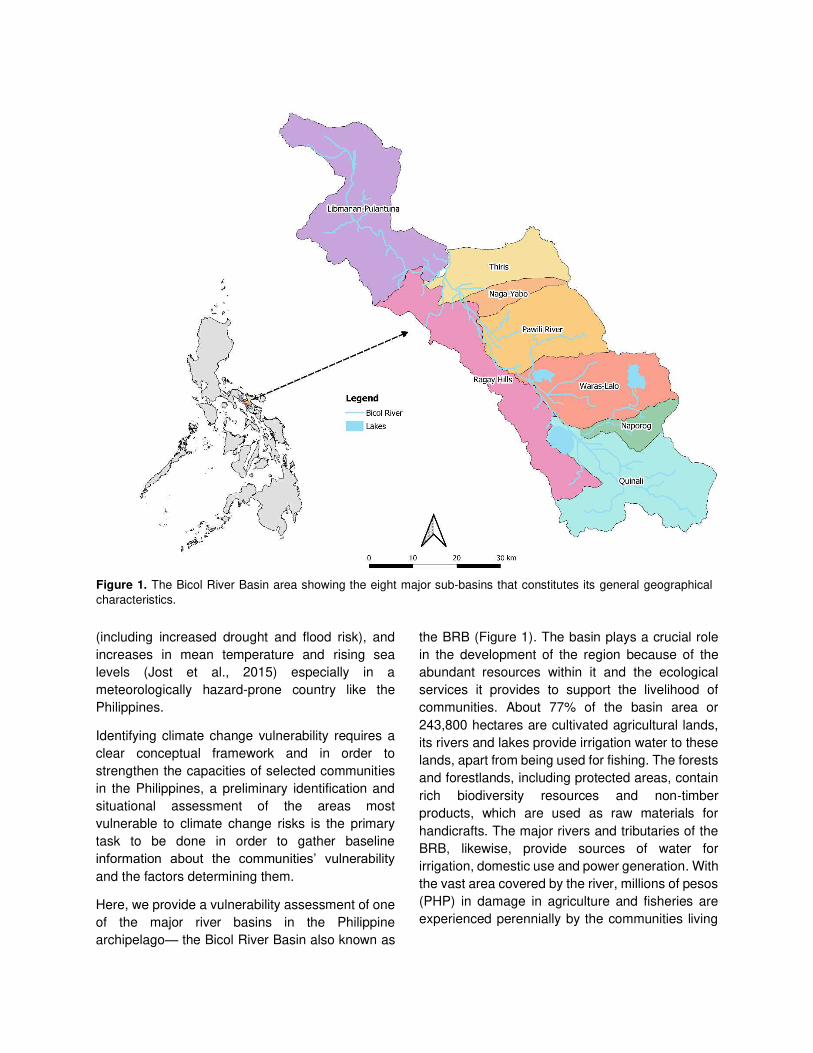
Here, we provide a vulnerability assessment of one
of the major river basins in the Philippine
archipelago— the Bicol River Basin also known as
the BRB (Figure 1). The basin plays a crucial role
in the development of the region because of the
abundant resources within it and the ecological
services it provides to support the livelihood of
communities. About 77% of the basin area or
243,800 hectares are cultivated agricultural lands,
its rivers and lakes provide irrigation water to these
lands, apart from being used for fishing. The forests
and forestlands, including protected areas, contain
rich biodiversity resources and non‐timber
products, which are used as raw materials for
handicrafts. The major rivers and tributaries of the
BRB, likewise, provide sources of water for
irrigation, domestic use and power generation. With
the vast area covered by the river, millions of pesos
(PHP) in damage in agriculture and fisheries are
experienced perennially by the communities living
Figure 1. The Bicol River Basin area showing the eight major sub-basins that constitutes its general geographical
characteristics.

along it, largely due to climate change (DENR,
2015).
To date, most literatures regarding BRB studies are
already outdated spanning from the 1970’s–1990’s.
Additionally, the majority of studies (Herrin, 2019:
Rola, et al., 2018: DENR, 2015: Abon, et al., 2012:
Meigh & Bartlett, 2010: Usamah & Alkema, 2006)
conducted in the BRB are mostly limited to socio-
economic profiling and analyses, inventory of
biophysical resources, hazard-risk assessments,
management regimes and/or the combinations
thereof. Motivated by these considerations, we
employed a combination of participatory social
research methods and the Climate Risk
Vulnerability Assessment (CRVA) framework using
the latest geospatial modelling through the use of
GIS data, and selected agricultural commodities
used for the ecological modelling and their
interaction within the spatial model structure to
assess the current vulnerability scenario of the BRB
and the components that is closely interlinked with
vulnerability. The participatory approach was used
to qualitatively understand the local vulnerability
perceptions and climatic contexts of the region and
accordingly, the CRVA approach was used to
quantitively determine the main hotspots of
vulnerability as the function of exposure, sensitivity
and adaptive capacity. Although a wide range of
methodological frameworks and approaches have
been developed and executed to analyze climate
vulnerabilities based on the resources and
production systems, timeframe and geographic
coverage, so far, we noted that the combination of
the methodologies mentioned has not been fully
documented in literature and thus, provides an
innovation to the application of this case study.
Since river basins are documented to be highly
susceptible to climate change (Dilshad et al., 2019;
Johnson & Hutton, 2014; Gohari et al., 2013), the
study intends to provide a clear visualization of the
current climate scenario of the vulnerable agri-
fishery communities living within the Bicol River
Basin in order to identify at administrative level
which areas are most vulnerable to the projected
impacts of climate change on agriculture and
recommend interventions for future policy
directions.
2. Methods
2.1. Study area. The Bicol River Basin (BRB) is an
integrated watershed resource that geographically
extends from 13°0’ – 14°0’ N to 123°0’ – 124°0’ E representing about 317,103 hectares of the land area
of the mainland Bicol Region in the Philippines and
largely embraces the provinces of Albay, Camarines
Sur and Camarines Norte. The basin encompasses
forty municipalities and three component cities
situated wholly or partially within the agro-river
system and categorically divided into eight sub-
basins namely, Libmanan-Pulantuna, Ragay Hills,
Thiris, Naga-Yabo, Pawili River, Waras-Lalo,
Naporog, and Quinali for managerial regimes. The
distinct geo-morphological features found in the area
include major geologic formations, which allows it to
be naturally divided into: the Bicol Plain, the
Sedimentary Terrain on its southwestern side and
Volcanic Terrain found on the eastern rim bounded by
a cordillera of five volcanic mountains. The BRB is
drained by a network of rivers and lakes and
principally by two major rivers: the Bicol River and
Libmanan River which finally empty into the San
Miguel Bay situated on the northeast. The climate in
the BRB is fundamentally governed by three
prevailing types of climatic variations: (i) no dry
season with very pronounced rainfall from November
to January; (ii) rainfall more or less evenly distributed
throughout the year; and (iii) not very pronounced dry
season from November to April and wet during the
rest of the year, for the upper portion, the central strip,
and the lower portion of the BRB, respectively.
2.2. Participatory analysis of stakeholders’ perception. Participatory and qualitative research
methods such as Participatory Rural Appraisal (PRA)
and Capacity Analysis, Focus Group Discussions
(FGD) with the multisectoral members of the
community, key informant’s interview (KII) and participant observation were employed in the study
adopted loosely from the study of Gentle & Maraseni
(2012). To analyze and gain the perception of the
stakeholders towards vulnerability, the vulnerability
matrix as qualitative tool was employed, briefly, major
climate hazards and livelihood resources were
identified and listed in a matrix by the respondents. In
this matrix, the major hazards and most impacted
livelihood resources were prioritized. Scoring for the
hazards against the livelihood resources was carried
out based on a Likert scale indicating the severity of
impacts brought about by the identified hazards,
which were represented by numerical values that

correspond to a certain degree of impact (i.e.
significant, moderate, minimal and no impact).
Accordingly, the identified respondents in this
process were farmer groups and irrigators’ associations, fisherfolks (lake, river, estuary and
coastal/marine fishers), private enterprises, local
government agriculture service providers, local
disaster risk reduction and management authorities
including agrometeorological experts operating within
the BRB.
2.3. Selection and collection of spatial data. In this
section, basically, geographic information system
(GIS) data which were mainly free and open-source
data at the finest spatial resolution possible were
collected and organized by scale from global to sub-
national (province to district) level (Table 1). In terms
of national and sub-national data collection where
data distribution is protected by data privacy
protocols, the figures sourced-out from various
governmental agencies and instrumentalities were
treated with discretion and utilized exclusively for
scholarly and management purposes.
Additionally, with regards to the selection of cash
crops to be utilized in the assessment, economically
essential crops that are principally cultivated in the
BRB were prioritized based on the region-based
census by the Department of Agriculture-Bicol (2017)
and the Philippine Statistics Authority (2019, 2018,
2012). The study identified and utilized five priority
crops for the assessment namely rice, corn, cassava,
taro, and tilapia. In order to prioritize which crops to
include in the CRVA, we identified crops based on two
indicators: (1) crops are important for food security,
and (2) crops are important sources of cash. To
assess the distribution of these crops, Species
Occurrence Points (SOPs) were obtained from
existing crop occurrence archives and mostly from
local experts through a participatory mapping
workshop. The mapping exercise was designed to
rapidly collect data from the field. Participants
achieved identification of crop location based on
personal knowledge, familiarity, and similarly relevant
records and literatures. The resulting intermediate
analog data plots were digitally exported on Google
Earth and afterwards, integrated into the spatial
model to enable further modelling and analyses.
Figure 2. Climate Risk Vulnerability Assessment (CRVA) framework adapted from Parker et al. (2019) with minor modifications. The
framework is classified in grey boxes according to the three main vulnerability components which were aggregated to determine the
final index of vulnerability. Arrows indicate the flow of the data from input to output of the GIS processes indicated in orange.
Multivariable datasets compiled in excel sheet are represented by horizontal open cylinders and raster spatial data by parallelograms
except for the climatic raster where blue and red colors refer to temperature and precipitation, respectively. Green parallelograms
indicate the output of the GIS process which are formatted into shapefile datasets. Finally, vertical closed cylinders are comma
delimited value (CSV) file which act as a database.

Validation was achieved through a series of
consultation both with the experts and the immediate
recipients of the generated putative maps.
2.4. Vulnerability assessment. In this section we
outline the approach as to how the multiscale spatial
data within the three components of vulnerability has
been aggregated to obtain an index of vulnerability
following the framework of the International Center for
Tropical Agriculture (CIAT) specifically from the works
of Parker et al. (2019). Modifications from the original
framework were implemented to tailor the Philippine
scenario, specifically by developing appropriate
weights per vulnerability component, by using
different sets of indicators for adaptive capacity and
using a different vulnerability equation, among others.
We would also like to note that the pooling of some
datasets from different sources as well as the
capacity building were sourced-out and sought from
CIAT-Philippines through the CIAT-AMIA project
(CIAT, 2016). The processes involved in the
aggregation were outlined in Figure 2.
2.4.1. Exposure assessment. For this component,
we further compartmentalized exposure into two
components: first, we estimated the changes in
temperature and precipitation between future
projection (decade 2050) and the current or baseline
conditions. And second, we factored-in several
biophysical indicators which corresponds to the
natural hazards exerting higher pressure to the
agricultural sector and rural livelihoods such as
tropical cyclone, flood, drought, saltwater intrusion,
erosion, landslide, sea level rise, and storm surge.
With regards to Exposure 1, in estimating the current
conditions, we used WorldClim (Hijmans et al., 2005),
a global database of high spatial resolution weather
and climate data. Using this database, spatially
interpolated gridded climate data using thin-plate
splines algorithm consisting of monthly total rainfall,
and maximum, mean and minimum temperature,
were aggregated across a target temporal range of
1970–2000 (Fick and Hijmans, 2017) to provide an
estimate to the current scenario. For the future
climate projection, we utilized the Representative
Concentration Pathway (RCP) 8.5 or the high
emission scenario based from the IPCC Assessment
Report 5. The RCPs form a set of greenhouse gas
concentration and emissions pathways designed to
support research on impacts and potential policy
responses to climate change (Moss et al. 2010; van
Vuuren et al. 2011). Among the four RCP, the RCP8.5
corresponds to the pathway with the highest
greenhouse gas emissions and combines
assumptions about high population and relatively
slow income growth among others (Riahi et al., 2011).
Considering the increasing trajectory of the current
net greenhouse gas emission of the present decade,
we inferred that providing projections using RCP8.5
would provide a more realistic estimate since this
RCP projects the highest increase in temperature
among the other RCPs. Subsequently, to model the
future climate scenario, we used the mean ensemble
of 33 General Circulation Models (GCMs) under
RCP8.5 scenario. Afterwards, using downscaled
datasets, the resulting data of the changes in
precipitation and temperature were calculated by
subtracting current to future climate scenario to
provide an overall estimation.
In terms of the approach to Exposure 2 also known
as ‘exposure to hazards’, spatially aggregated
datasets of the identified natural hazards were
acquired from national sources (summarized in Table
1). Local experts consisting of agriculturists, DRRM
experts and representatives from the academe were
involved for the CRVA studies in the Philippines.
Different weights were assigned to each identified
hazard with respect to the three island groups in the
Philippines based on probability of occurrence,
impact to national economy, impact to food security
of the country, impact to local household income, and
finally, impact to key natural resources to sustain
productivity (i.e., water quality & quantity, biodiversity,
soil fertility). Scoring for the hazard weights were
represented by numerical values (1-5) that
correspond to an adjectival interpretation. In terms of
the probability of occurrence: once in every year,
once in every 5 years, or once every 10 years or
more, were used. Accordingly, insignificant, minor,
moderate, significant, or disastrous, were used for
impact. For this study, we only utilized the weighted
values for Luzon island since the BRB is situated
solely within the Luzon region. Finally, to generate the
hazard index, the mean values of aggregate weight
for each municipality were computed. Normalization
was employed to rescale all the values from 0 to 1.
Accordingly, five equal breaks were used to establish

the thresholds for the following classes: 0–0.20 (Very
Low), 0.20–0.40 (Low), 0.40–0.60 (Moderate), 0.60–0.80 (High), and 0.80–1.00 (Very High).
2.4.2. Sensitivity assessment. Crop sensitivity was
assessed by analyzing changes in climatic suitability
of crops by the year 2050 in comparison with the
current crop suitability. For this study sensitivity is
described as the change in the climatic suitability of
an area to grow a crop (Parker et al., 2019). To
estimate this change, we subtracted the future
climatic suitability from the current suitability. To
model the climatic suitability of individual crops, we
utilized the MaxEnt model (Elith et al., 2011) for rice,
corn, cassava, taro, and tilapia since this model has
been seen to perform well for crops that are often
irrigated (Parker et al., 2019). Accordingly, this
modelling approach is a niche-based model that
assumes the distribution of observations, i.e.,
presence data and represents the realized niche
(Heumann et al., 2011).
In order to perform necessary modelling approaches,
we relied on twenty (20) statistically downscaled
current and future bioclimatic variables which are
derived from annual, quarterly, monthly and daily
temperature and rainfall values for the purpose of
producing variables that are biologically relevant.
These bioclimatic variables were integrated together
with the respective crop in order to produce climate
suitability maps under current conditions and
employed expert feedback to validate the accuracy of
the map and its inputs. After which, the future data
(2050), using a set of 33 statistically downscaled
GCMs for the RCP8.5 emissions scenario was
integrated to the niche crop model to generate 33
Figure 3. Species occurrence points of priority commodities
that are principally cultivated within the Bicol River Basin. Each
crop is given corresponding color for visualization. Crop
occurrences outside the BRB border was also depicted to
facilitate comparison of the vegetation cover within the area.

projected suitability outputs. From this, we computed
for the average and the standard deviation to assess
the degree of variability of the GCMs. We finally
calculate the change (%) between the current and
projected suitability, extract the values for each
administrative unit and provided classifications in
terms of the sensitivity indices. An index of -0.25 – -
1.0 means an increase in suitability while 0.25–1.0
means a loss in suitability. The index equal to 0
means there is no change in suitability detected from
current to projected or because there is just no crop
presence.
2.4.3. Adaptive capacity assessment. In this study,
adaptive capacity (AC) is understood as the ability of
a system to adjust and respond to the changes in
climate. Among the three components of vulnerability,
it is the aspect directly correlated with resilience. For
this component, we compiled datasets (Table 1) for
each of the respective attribute capitals (social,
economic, health, human, institutional, natural,
physical, anticipatory) derived from up-to-date
available data mainly from 2015 and downscaled on
municipal level in the context of climate change
effects to agriculture. The indicators enumerated in
this study are flexible and very context specific. In our
case, it is very useful in providing an estimate as to
the availability of resources vis-à-vis absorptive
capacity of the communities of each municipality. The
values of the sub-indicators (Table 1) were converted
to a GIS spatial format by linking it to the shapefile
municipal boundaries. The sum of the capitals was
used as the adaptive capacity index. Values were
normalized and five equal breaks were developed to
show low to very high adaptive capacity: 0–0.20 (Very
Low), 0.20–0.40 (Low), 0.40–0.60 (Moderate), 0.60–0.80 (High), and 0.80–1.00 (Very High).
2.4.4. Final vulnerability index assessment. In this
section, we finally combined the different components
of vulnerability consisting of the normalized values of
exposure to natural hazards, crop sensitivity, and
adaptive capacity to calculate for the overall
vulnerability at the administrative boundary scale. To
determine the weighted contributions to each
component, a balanced weight approach (Hahn et al.,
2009; Sullivan, 2002) was used in this index. The
weighting scheme can be adjusted to reflect the
perceived importance of specific factors
(Krishnamurthy et al., 2014). For example, as
suggested by Eakin and Bojorquez-Tapia (2008), to
determine the weightings for indicators we adopted
values as a result of focus groups and expert
workshop led by national experts through a national
workshop to gain a consensus on the final weight to
be assigned for each vulnerability component. As a
result, the experts suggested an overall vulnerability
assessment weights of “Hazards (15%)”, “Sensitivity (15%)”, and attributed the highest importance in defining vulnerability to “Adaptive Capacity (70%)”.
The calculation and analysis were subsequently
carried out and mapped on QGIS 3.4 (Madeira)
software. After assimilating the assigned weights to
each respective component indices, the overall
vulnerability was determined by aggregating the
indices of the potential impact (Haz + Sensi) and
adaptive capacity (AC). For this, we employed the
equation presented below.
𝑉𝑢𝑙𝑛𝑒𝑟𝑎𝑏𝑖𝑙𝑖𝑡𝑦 𝑖𝑛𝑑𝑒𝑥 = ∑[𝐻𝑎𝑧(𝑤ℎ)] + [𝑆𝑒𝑛𝑠(𝑤𝑠)]𝑖 + [1 − 𝐴𝐶(𝑤𝑎)]𝑖=1 𝐄𝐪. 𝟏
Where: i = crop, Haz = hazard index, Sensi =
sensitivity index of the crop, and AC = adaptive
capacity index. wh = weight given for hazard, ws =
weight given for sensitivity, and wa = weight given for
adaptive capacity.
Subsequently, expert validation was sought at
various stages of the methodology (Figure 2); several
stakeholders of every administrative unit participated
in this consultation, consisting of agriculture service
providers, DRRM and planning officers. As a heuristic
tool, in certain cases that the expert recognizes areas
where the model presents certain inconsistencies or
inaccuracies, we subsequently re-run the model
incorporating the experts’ recommendations and present the restructured results, we repeat this
process until the maps capture the relative spatio-
temporal conditions of each administrative area. This
feedback mechanism is critical in order to improve the
accuracy and validity of the maps generated. After
obtaining the final validated scores, we subsequently
summarized the distribution of vulnerability index
scores through a kernel density plot and employed
statistics using R software. We then categorized
vulnerability according to the vulnerability score using
the following conditions, Very Low-Low (Vulnerability

≤ 0.40), Moderate (0.425 ≤ Vulnerability ≤ 0.60) and High-Very High (Vulnerability ≥ 0.625).
3. Results and Discussions
3.1. Perceptions of vulnerability in the BRB
In this context, we initially conducted species
occurrence survey to assess the vegetation cover
in the BRB. For this, Figure 3 presents the
occurrence points of priority commodities that are
principally cultivated in the region. It can be
distinctly noted that majority of these crops are
grown within the boundaries of the basin, most
prominently in its central portion where almost all
crops converge along the major rivers and
tributaries where supplies of freshwater are
discriminately abundant. Consequently, this
creates an environment of uncertainty and presents
a major concern to marginalized small-scale
farmers since largescale inundation is the most
pervasive hydrological hazard that threatens the
extensive low-lying Bicol Plain (DENR 2015;
Mascariñas et al., 2013: Abon, et al., 2012). As part
of Climate Vulnerability and Capacity Analysis
(CVCA), a vulnerability matrix was prepared to gain
perceptions on the vulnerability of the agriculture
sector from its grassroot level. The methodology
helps to better understand the implications of
climate change on community-level livelihoods and
examines both hazards and conditions of poverty
and analyzes the interactions between them. The
approach supports the collection of locally specific
information on risks, vulnerabilities and capacities
in relation to climate-related shocks, stresses and
uncertainties and facilitates analysis of these
information in ways that can unearth differences
based on socioeconomic characteristics that
influence resilience (Daze et al., 2009). Participated
by various stakeholders operating within the BRB,
it was revealed that besides from frequent flooding,
typhoon was perceived to contribute the most
significant impact on the prioritized livelihood
resources that arise from these communities.
Notably, although water supply in the area should
be considerably sufficient because of the wide
coverage of the Bicol River, the occurrence of
drought still significantly affects the area.
Additionally, the occurrence of saltwater intrusion in
freshwater systems in the areas located along the
low-lying coastal lands was also identified to be a
potent contributor in the decreased productivity of
major agricultural practices since it has been
documented that soil biogeochemistry can be
dramatically altered as saltwater intrudes these
agricultural fields (Tully et al., 2019). These
problems arise considerably due to water
management facilities and infrastructures that are
poorly designed, misaligned, operationally
underperforming or constructed disproportionately
to function during such debilitating scenarios. The
presence of pests and diseases as well as farm
vermin were also identified to cause significant to
moderate impact on major agricultural products
these include pests such as the black bugs
(Scotinophara spp.), stem borer larvae
(Scirpophaga spp. & Chilo spp.), armyworms
(Spodoptera spp.) and green leafhoppers
(Nephotettix spp.) which also transmit the viruses
that cause rice tungro disease and other various
plant diseases such as mildew and anthracnose
caused by fungi and bacterial blights. Other farm
pests were also reported to cause major crop
damages such as golden apple snails (Pomacea
canaliculata) and other larger wild animals such as
farm rats (Rattus spp.) and rice-eating birds
(Lonchura spp. & Passer montanus). Accordingly,
the most vulnerable livelihood determined by the
stakeholders revealed to be rice cultivation followed
by the high-value crops and then the livestock and
poultry based on the composite data (Figure 4).
3.2. Main context of vulnerability
Given the rate and breadth to which climate change
is already exerting increased pressure upon many
vulnerable communities (Gentle & Maraseni, 2012;
Laukkonen, et al., 2009), and the relatively finite
resources available to various stakeholders to
mitigate its impacts (Buchner, et al., 2017), it is of
paramount importance that interventions are
strategically planned and implemented (Weis et al.,
2016). Over the past decade, there is an increasing
body of literature that focused on evaluating the
vulnerability of various sectors to climate change,
including agriculture (Jurgilevich, et al., 2017:
Mallari, 2016: Acheampong, et al., 2014: Wu, et al.,

2011: Ford, et al., 2010). Characterizing
vulnerability is central to identifying adaptation
needs and informing adaptation policy
development (Ford, et al., 2010). It is integral,
therefore, in all vulnerability assessment
undertakings to keenly understand what constitutes
vulnerability; a number of studies (Vos, et al., 2016:
Baca, et al., 2014: Füssel, 2010: Deressa, et al.,
2008) have adopted what seems to be the most
authoritative (Hinkel, 2011) definition of
vulnerability developed by the Intergovernmental
Panel on Climate Change (IPCC) (IPCC, 2001:
McCarthy, et al., 2001) which can be defined as “the extent to which a natural or social system is
susceptible to sustaining damage from climate
change impacts, and is a function of the character,
magnitude, and rate of climate variation to which a
system is exposed, its sensitivity, and its adaptive
capacity” (McCarthy, et al., 2001). The susceptibility of agriculture and livelihoods to
climate change therefore can be presented as the
aggregation of these composite components
(Fritzsche, et al., 2014).
Meanwhile, it is crucial to understand that
vulnerability is not a quantifiable phenomenon, it is
instead a dynamic state which is the result of
various interacting variables (Fritzsche, et al.,
2014). As it cannot be measured or observed
directly (Sherbinin, et al., 2017; Hamouda, et al.,
2009), a number of indicators which are presumed
to affect vulnerability are aggregated or combined
to provide an indication, or an index of vulnerability.
Likewise, it is a relative scale which shows the
spatial distribution of vulnerability within a specific
location of analysis, which in our case is a water
system. The aforementioned components or
indicators are commonly used variables of
agricultural vulnerability (Fritzsche, et al., 2014).
Briefly, these indicators capture a region’s high biophysical and climate risks (Exposure), resilience
of the crop production systems (Sensitivity) and
societal capacity to respond (Adaptive Capacity).
3.3. Vulnerability scenario in the BRB
The following section summarizes the results of the
vulnerability indexing exercise. For comparison, it is
important to note that index values should be
interpreted as relative, rather than indicative, within
the context of the analysis. The putative maps can
be interpreted as a baseline showing the
vulnerability of administrative regions, relative to
each other, based on available climate and
socioeconomic profiles.
Typhoon Flooding Drought Pestilence Saltwater Intrusion
Ma
jor
Liv
elih
oo
ds
Rice cultivation
High-value crops cultivation
Livestock and poultry rearing
Fishing and aquaculture
Wage labor
Significant Magnitude of Impact No Impact
Figure 4. Vulnerability matrix representing stakeholders’ (N=330) perception towards vulnerability of the agriculture sector
in terms of rural livelihoods versus the major hazards that is widely experienced in the Bicol River Basin. Results are
expressed across a color gradient that represents the perceived magnitude of impact from crimson (significant), light red
(moderate), orange (minimal) to light yellow (no impact) following the Likert scale.

The results suggest that there are geographical
patterns of climate-related vulnerability within the
BRB (Figure 5). Notably, Thiris sub-basin
(composed mainly of the towns of Calabanga,
Bombon, Magarao, and Canaman) is significantly
vulnerable to the impacts of climate change along
with other parts of Ragay Hills (Minalabac, Milaor,
Balatan and parts of Pasacao), Waras-Lalo (Baao)
and the Libmanan-Pulantuna (Del Gallego,
Cabusao, and Lupi) sub-basins, due to loss in the
climatic suitability, the presence of multiple natural
hazards (tropical cyclone, flooding, drought and
some expected saltwater intrusions) and also the
relatively low adaptive capacity in these areas. On
the contrary, the Quinali sub-basin (composed of
the towns of Camalig, Guinobatan, Libon, Ligao
City, Oas, and Polangui) wholly has the capacity to
resist climate change relative to cultivating these
crops together with some parts of Waras-Lalo (Iriga
City and Nabua), Pawili River (Pili) and the
northeastern portion of the Libmanan-Pulantuna
(San Lorenzo Ruiz, Basud, Sipocot, and parts of
Mercedes). Overall percentages show that 42% of
the towns in the BRB are relatively characterized by
high to very high vulnerability, whereas, 37% are
characterized by low to very low vulnerability.
Accordingly, the remaining 21% of the towns are
relatively characterized moderate. This suggests
three important observations which may need
further empirical analysis. First, communities within
the BRB greatly rely on agri-based enterprises
(Figure 4) for food security that in essence, heavily
depends on the climate, therefore, food productivity
and changes in the climate is closely interlinked.
Second, climate change has the capacity to
potentially disrupt the agri-food value chains (Lim-
Camacho, et al., 2017) to which food security
heavily depends. And third, climate change tends to
impact communities disproportionately which
further exacerbates poverty across the BRB. These
vastly illustrates how the consequences of
vulnerability will reverberate across highly
vulnerable areas in the BRB if not addressed
urgently and holistically.
To further analyze the trend of vulnerability across
the BRB, we summarized the distribution of
vulnerability index scores through a kernel density
plot (Figure 5). Data distribution for vulnerability
yielded a bimodal distribution such that the average
vulnerability category is moderate (0.492) with the
main peak at around 1.5 and a lower peak around
1.1. However, the distribution suggests a
segregation of two distinct local maxima consisting
of vulnerability scores that relatively fall under
distinct ranges of high (>0.625) and low (<0.40)
vulnerability categories, respectively. The
dimensional nature of the data arises as a result of
how climate change impacts every single
administrative unit disproportionately. Adaptive
capacity affects vulnerability by modulating
exposure and sensitivity (Yohe and Tol, 2002;
Adger et al., 2007). Considering that adaptive
capacity has been attributed the highest importance
in defining vulnerability in this study, contributing
about 70% in the overall determination of the final
index, we infer that administrative units or towns
with increased adaptive capacity have the
likelihood to cope with the effects of climate
pressures thereby resulting to a relatively lower
climate vulnerability, these gradually adds up to
form the global maximum (main peak). This is
particularly true since these areas tend to have
higher economic activity and availability of financial
services, good access to health and education, and
have more provision in terms of support services for
agriculture. Whereas, towns that are disadvantaged
in this aspect have relatively high vulnerability,
therefore, clusters to form the local maximum
(lower peak). The graph, therefore, implies that
although there exist a considerable number of
towns that have relatively high coping chances,
majority of the towns are still vulnerable to the
impacts of climate-related risks.
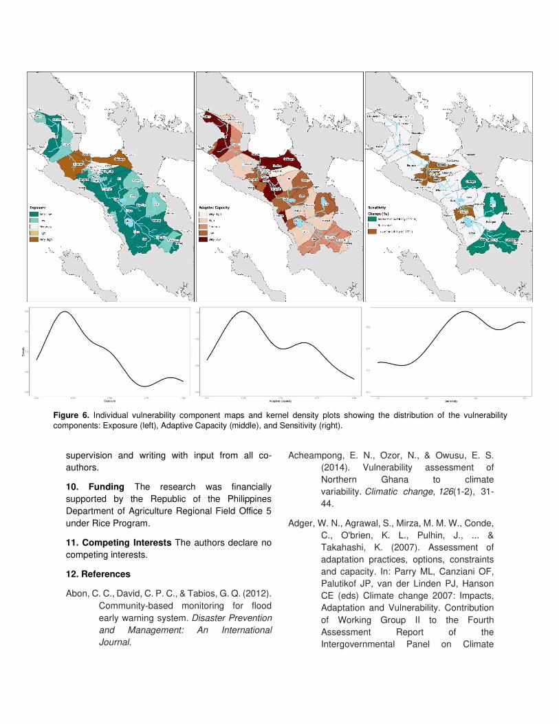
The geographical and density distributions of the
specific indicators shown in Figure 6 further reveal
each indicators contribution to the overall
vulnerability of the BRB. First, hazard exposure for
the BRB was observed to be highest in some parts
of the Thiris and southern portion of the Libmanan-
Pulantuna sub-basins characterizing about 9% of
the overall exposure of the BRB, primarily
attributable to their location along the typhoon track
found within the latitude range 14°N–16°N where
most tropical cyclones typically landfall (Takagi &
Esteban, 2016: Meigh & Bartlett, 2010) which
encourages further risks brought about by storm

surges and sea level rise due to their immediate
proximity to the seaboards, which in turn bring
further flooding and occasional soil erosion in these
areas. Moreover, adaptive capacity (AC) tends to
be lowest in some portions of the Libmanan-
Pulantuna and Ragay Hills sub-basins and very
notable entirely in the Thiris sub-basin, additionally,
some towns within the sub-basins of Pawili River,
Waras-Lalo and remaining parts of Ragay Hills are
also characterized by low AC comprising about
58% of the overall adaptive capacity of the towns in
the BRB. Finally, in terms of sensitivity, the
averaged values of the five (5) major crops
considered in this study suggests a decline in
suitability (21%) in the central portion of the BRB
along the borders of Libmanan-Pulantuna, Thiris
and Ragay Hills including a town in the Waras-Lalo
sub-basin. Nevertheless, increased suitability
(21%) is observed in the southern portion of the
Quinali and parts of the Waras-Lalo and Pawili
River sub-basins, remaining towns was observed to
have no change in suitability (58%). The challenge
for policy now will be on how to mobilize
contingency measures, initiate responsibility, and
stimulate conversation amongst concerned
stakeholders and policy makers in terms of
investing in climate change adaptation strategies
and heightened risk managements in the areas
characterized by high vulnerability.
4. Limitations
Notwithstanding the seamless projection generated
by the model, several limitations and caveats apply
to our study. First, we acknowledged that the
climate model outputs contain uncertainties due to
factors such as lack of capability to represent the
complexity of Earth’s climate system, multiple emission scenarios, and unaccounted ecological
and anthropogenic processes. However, despite
such uncertainties, models remain a useful tool to
forecast the impact of the future climate (Upgupta,
et al., 2015). For future studies, we recommend the
use of multiple modelling tools, since it can reduce
the level of uncertainty (Alam and Starr, 2013).
Second, although our model allows for identifying
the sensitivity of the area, bioclimatic factors and
species occurrence were only used for the basis of
the future projection, supplemental indicators like
elevation, soil texture, and soil moisture were
disregarded since most of the commodities grown
in the BRB are strictly distributed throughout the
Bicol Plain (Figure 3) where pedological properties
(Carating, et al., 2014) remain relatively uniform.
Moreover, there still exist conceptual confusions on
how vulnerability should be formally defined (Wolf,
et al., 2013: Hinkel, 2011). The plurality of existing
frameworks and possible interpretations even the
selection of indicating variables are still contestable
from a scientific point of view. Hinkel (2011)
provided a framework where he decomposed the
IPCC definition on the basis of the definitions of the
defining concepts given in glossary of the Third
Assessment Report (McCarthy et al., 2001) and
presented concepts that are left undefined on a
scientific purview. For simplicity, we kept the well-
established definition of the IPCC to provide context
to our readers suggesting that the definition to be
conventional. Further researches should be
conducted to explicitly provide standardized
terminologies to address these gaps.
5. Conclusions and recommendations
With the growing challenges confronted by the local
agriculture sector, well-placed policy and
institutional strategies would significantly contribute
in mitigating the consequences of the volatilities
brought about by the current climate scenario.
Additionally, tailor-made adaptation policies should
be conceptualized since agricultural practices exist
in a unique set of conditions relative to its ecological
importance, current biophysical status, the past
history of management, stakeholder dynamics,
local customs and traditions, local community-
based institutions, and local economy (Upgupta, et
al., 2015). In a broader sense, studying the multi-
faceted aspects of climate change falls not only at
the forefront of the academia instead it transcends
into a collaborative political and social duty.
Information generated by vulnerability
assessments is meant to cater further policy
purposes such as updating of local climate change
action plans (LCCAP) and advocating for common-
sense climate solutions like clean energy
promotion, climate-resilient agriculture practices,
and regenerative agriculture among others.
Assessing vulnerability thus has moved from being

Figure 5. Climate vulnerability scenario (2050) under a high emission scenario (RCP 8.5) of the Bicol River Basin, calculated as a
function of exposure to natural hazards, sensitivity of selected crops to climate change and adaptive capacity of the population.
Kernel density plot shows the summarized distribution of vulnerability index scores across administrative units.

being an academic exercise to being a political
necessity (Hinkel, 2011).
Our findings can therefore be utilized especially by
local government units (LGUs) to attract bilateral
and multilateral support from various local and
international stakeholders, prioritize and inform
climate adaptation efforts that will minimize its
impacts. Bolstering the adaptive capacity of
vulnerable areas particularly in the Thiris sub-basin
including some parts of Ragay Hills, Waras-Lalo
and the northwestern Libmanan-Pulantuna sub-
basins, that is, improving education, income
distribution, healthcare, pre- and post-disaster
responses, institutional and administrative
capacity-building (e.g. greater enforcement of
regulations and norms, investment in human
capital, decreasing corruption and inefficiencies),
and increased accessibility to early warning
systems and climate information services may help
offset projected increases in vulnerability. It is also
essential to upgrade water management facilities
and retrofit existing infrastructures since it has been
found out that saltwater intrusion and largescale
flooding continues to persist in the area. Other sub-
regions of the BRB with moderate to low
vulnerability are recommended to practice gradual
crop shifting in order to maintain the comparative
advantage of the farmers. Policy makers may wish
to build capacities for autonomous risk
management and adaptation as part of social
contracts to marginalized communities by providing
livelihoods through strengthened public investment
and support. Likewise, strategies to promote
resilience of ecosystems should also be given
significant attention across the BRB since a wide
range of ecosystem services provided by the basin
are threatened by anthropogenic activities such as
timber poaching, mangrove conversion, and over-
fishing among others. These strategies should
include but not limited to protection of existing
natural forests, rehabilitation of degraded
forestlands and protected areas, management of
mangroves, wetlands and coastal resources and
management of river easements, including
resettlement planning and implementation.
In conclusion, our results highlighted specific
regions of the Bicol River Basin where projected
climate vulnerability will be expected to be
widespread and robust, including the vulnerability
perceptions of the local communities that are
disproportionately influenced by the climate crisis.
These findings have large implications on how
agriculture will transform in the future into a climate
smart endeavor. We find that the model currently
projects that majority of the towns in the north and
central portions of the BRB will largely experience
decline in agricultural productivity, if, stringent
adaptation and mitigation measures will not be
strategized and established henceforth. The main
idea is that, knowing the key drivers of vulnerability
allows for a more targeted action. For this, it is vital
that location-specific needs-based legislations
should be established that shall help prioritize,
protect, support, and incentivize the local
agriculture sector most importantly its farmers — as
they remain to be one of the country’s economic
backbone and pride of the working class.
6. Acknowledgements
This work was financially supported by the
Department of Agriculture Regional Field Office 5
under Rice Program through the initiatives and
support of its former regional executive director Dr.
Elena B. De Los Santos. The authors acknowledge
Director Rodel P. Tornilla and the Bicol AMIA team
headed by Mr. Lorenzo L. Alvina for their support
and technical assistance. The same
acknowledgement is given to Dr. Raul G. Bradecina
for his insightful comments and suggestions. We
thank Mr. Leo Kris M. Palao of CIAT Asia for
providing supplementary materials for the analysis.
The authors also honor the contribution of the
people in the research sites for their cooperation,
support, and invaluable feedbacks during the
project implementation.
7. Ethical Approval Not applicable.
8. Consent to Participate Written informed
consent was obtained from all individual
participants included in the study.
9. Authors Contributions R.P. Laureta and R.R.H.
Regalado designed the study. R.R.H. Regalado
performed the analyses and data curation, with
support from E.B. De La Cruz who also contributed
materials/analysis tools. R.P. Laureta led the
supervision and writing with input from all co-
authors.
10. Funding The research was financially
supported by the Republic of the Philippines
Department of Agriculture Regional Field Office 5
under Rice Program.
11. Competing Interests The authors declare no
competing interests.
12. References
Abon, C. C., David, C. P. C., & Tabios, G. Q. (2012).
Community‐based monitoring for flood
early warning system. Disaster Prevention
and Management: An International
Journal.
Acheampong, E. N., Ozor, N., & Owusu, E. S.
(2014). Vulnerability assessment of
Northern Ghana to climate
variability. Climatic change, 126(1-2), 31-
44.
Adger, W. N., Agrawal, S., Mirza, M. M. W., Conde,
C., O'brien, K. L., Pulhin, J., ... &
Takahashi, K. (2007). Assessment of
adaptation practices, options, constraints
and capacity. In: Parry ML, Canziani OF,
Palutikof JP, van der Linden PJ, Hanson
CE (eds) Climate change 2007: Impacts,
Adaptation and Vulnerability. Contribution
of Working Group II to the Fourth
Assessment Report of the
Intergovernmental Panel on Climate
Figure 6. Individual vulnerability component maps and kernel density plots showing the distribution of the vulnerability
components: Exposure (left), Adaptive Capacity (middle), and Sensitivity (right).

Change. Cambridge University Press,
Cambridge, 717–743.
Alam, S. A., & Starr, M. (2013). Impacts of climate
change on savannah woodland biomass
carbon density and water-use: a modelling
study of the Sudanese gum belt
region. Mitigation and Adaptation
Strategies for Global Change, 18(7), 979-
999.
Alberto, M. C. R., Hirano, T., Miyata, A.,
Wassmann, R., Kumar, A., Padre, A., &
Amante, M. (2012). Influence of climate
variability on seasonal and interannual
variations of ecosystem CO2 exchange in
flooded and non-flooded rice fields in the
Philippines. Field Crops Research, 134,
80-94.
Baca, M., Läderach, P., Haggar, J., Schroth, G., &
Ovalle, O. (2014). An integrated framework
for assessing vulnerability to climate
change and developing adaptation
strategies for coffee growing families in
Mesoamerica. PloS one, 9(2), e88463.
Buchner BK, Oliver P, Wang X, Carswell C, Meattle
C, Mazza F. Global Landscape of Climate
Finance 2017 [Internet]. Climate Policy
Initiative; 2017. Available:
https://climatepolicyinitiative.org/wp-
content/uploads/2017/10/2017-Global-
Landscape-of-Climate-Finance.pdf
Carating, R. B., Galanta, R. G., & Bacatio, C. D.
(2014). The soils of the lowlands. In The
Soils of the Philippines (pp. 51-106).
Springer, Dordrecht.
International Center for Tropical Agriculture (CIAT).
(2016). Climate-Risk Vulnerability
Assessment (CRVA) to support regional
targeting and planning for the Adaptation
and Mitigation Initiative in Agriculture
(AMIA) [Internet]. Available:
https://ciat.cgiar.org/ciat-projects/climate-
risk-vulnerability-assessment-crva-to-
support-regional-targeting-and-planning-
for-the-adaptation-and-mitigation-initiative-
in-agriculture-amia/
Climate Change and Food Security (CCAFS).
(2015). GCM Downscaled Data Portal
[Internet]. Available: http://www.ccafs-
climate.org/data_spatial_downscaling
Daze, A., Ambrose, K., Ehrhart, C. (2009). Climate
Vulnerability and Capacity Analysis-
Handbook. CARE International.
http://www.careclimatechange.org
Department of Environment and Natural Resources
(DENR). (2015). Formulation of an
Integrated Bicol River Basin Management
and Development Master Plan Executive
Summary Vol. 1. Naga City: Department of
Environment and Natural Resources.
Department of Agriculture. (2017). 2017 Annual
Report. Pili, Camarines Sur: Department of
Agriculture Regional Field Office 5
Planning, Monitoring & Evaluation Division.
Retrieved from
http://bicol.da.gov.ph/rfo5newweb/wp-
content/uploads/2019/02/DA-RFO-5-
Annual-Report-2017-web.pdf
Department of Agriculture Systems-Wide Climate
Change Office (DA-SWCCO). (2017). How
to use the National Color-Coded
Agricultural Guide (NACCAG) Map.
Retrieved from
http://swcco.da.gov.ph/index.php/2017/08/
02/how-to-use-the-national-color-coded-
agricultural-guide-naccag-map/
Deressa, T., Hassan, R. M., & Ringler, C.
(2008). Measuring Ethiopian farmers'
vulnerability to climate change across
regional states. Intl Food Policy Res Inst.
Dilshad, T., Mallick, D., Udas, P. B., Goodrich, C.
G., Prakash, A., Gorti, G., ... & Habib, N.
(2019). Growing social vulnerability in the
river basins: Evidence from the Hindu Kush
Himalaya (HKH) Region. Environmental
Development, 31, 19-33.
Doroteo, H. J. (2015). Philippines: Disaster risk
profile and Disaster Risk Reduction (DDR)
framework: Natural calamities. University
of Oviedo, Asturias, Spain, 1-46.

Eakin, H., & Bojórquez-Tapia, L. A. (2008). Insights
into the composition of household
vulnerability from multicriteria decision
analysis. Global Environmental
Change, 18(1), 112-127.
Elith, J., Phillips, S. J., Hastie, T., Dudík, M., Chee,
Y. E., & Yates, C. J. (2011). A statistical
explanation of MaxEnt for
ecologists. Diversity and
distributions, 17(1), 43-57.
ESCAP & UNISDR. (2012). Reducing vulnerability
and exposure to disasters: the Asia-Pacific
Disaster Report 2012. Economic and
Social Commission for Asia and the Pacific
and the United Nations Office for Disaster
Risk Reduction, Regional Office, AP,
Thailand
FAO, 2000. In: FAO (Ed.), The Ecocrop Database.
Rome, Italy.
Fick, S. E., & Hijmans, R. J. (2017). WorldClim 2:
new 1‐km spatial resolution climate
surfaces for global land
areas. International Journal of
Climatology, 37(12), 4302-4315.
Ford, J. D., Keskitalo, E. C. H., Smith, T., Pearce,
T., Berrang‐Ford, L., Duerden, F., & Smit,
B. (2010). Case study and analogue
methodologies in climate change
vulnerability research. Wiley
Interdisciplinary Reviews: Climate
Change, 1(3), 374-392.
Fritzsche K, Schneiderbauer S, Bubeck P,
Kienberger S, Buth M, Zebisch M, et al.
(2014). The Vulnerability Source Book.
Concept and guidelines for standardised
vulnerability assessments. Deutsche
Gesellschaft für Internationale
Zusammenarbeit (GIZ) GmbH. Available:
http://www.
adaptationcommunity.net/?wpfb_dl=203
Füssel, H. M. (2010). Review and quantitative
analysis of indices of climate change
exposure, adaptive capacity, sensitivity,
and impacts. Washington, DC: World Bank.
Gentle, P., & Maraseni, T. N. (2012). Climate
change, poverty and livelihoods:
adaptation practices by rural mountain
communities in Nepal. Environmental
science & policy, 21, 24-34.
Gohari, A., Eslamian, S., Abedi-Koupaei, J.,
Bavani, A. M., Wang, D., & Madani, K.
(2013). Climate change impacts on crop
production in Iran's Zayandeh-Rud River
Basin. Science of the Total
Environment, 442, 405-419.
Hahn, M. B., Riederer, A. M., & Foster, S. O. (2009).
The Livelihood Vulnerability Index: A
pragmatic approach to assessing risks
from climate variability and change—A
case study in Mozambique. Global
environmental change, 19(1), 74-88.
Hamouda, M. A., El-Din, M. M. N., & Moursy, F. I.
(2009). Vulnerability assessment of water
resources systems in the Eastern Nile
Basin. Water resources
management, 23(13), 2697-2725.
Herrin, A. N. (2019). Fertility and family planning
behavior in the Bicol river
basin. Transactions of the National
Academy of Science and
Technology/National Academy of Science
and Technology.(Bicutan, Taguig: NAST).
Heumann, B. W., Walsh, S. J., & McDaniel, P. M.
(2011). Assessing the application of a
geographic presence-only model for land
suitability mapping. Ecological
informatics, 6(5), 257-269.
Hijmans, R. J., Cameron, S. E., Parra, J. L., Jones,
P. G., & Jarvis, A. (2005). Very high-
resolution interpolated climate surfaces for
global land areas. International Journal of
Climatology: A Journal of the Royal
Meteorological Society, 25(15), 1965-
1978.
Hijmans, R.J., Guarino, L., Cruz, M., Rojas, E.,
2001. Computer tools for spatial analysis of
plant genetic resources data. 1. DIVA-GIS.

Plant Genetic Resources Newsletter 127,
15–19.
Hinkel, J. (2011). “Indicators of vulnerability and adaptive capacity”: towards a clarification of the science–policy interface. Global
environmental change, 21(1), 198-208.
IPCC. (2001). Climate Change 2001: Synthesis
Report. A Contribution of Working Groups
I, II, and III to the Third Assessment Report
of the Intergovernmental Panel on Climate
Change [Watson, R.T. and the Core
Writing Team (eds.)]. Cambridge University
Press, Cambridge, United Kingdom, and
New York, NY, USA.
Jost, C., Kyazze, F., Naab, J., Neelormi, S.,
Kinyangi, J., Zougmore, R., ... &
Kristjanson, P. (2016). Understanding
gender dimensions of agriculture and
climate change in smallholder farming
communities. Climate and
Development, 8(2), 133-144.
Johnson, F. A., & Hutton, C. W. (2014).
Dependence on agriculture and ecosystem
services for livelihood in Northeast India
and Bhutan: vulnerability to climate change
in the Tropical River Basins of the Upper
Brahmaputra. Climatic change, 127(1),
107-121.
Jurgilevich, A., Räsänen, A., Groundstroem, F., &
Juhola, S. (2017). A systematic review of
dynamics in climate risk and vulnerability
assessments. Environmental Research
Letters, 12(1), 013002.
Krishnamurthy, P. K., Lewis, K., & Choularton, R. J.
(2014). A methodological framework for
rapidly assessing the impacts of climate
risk on national-level food security through
a vulnerability index. Global Environmental
Change, 25, 121-132.
Laukkonen, J., Blanco, P. K., Lenhart, J., Keiner,
M., Cavric, B., & Kinuthia-Njenga, C.
(2009). Combining climate change
adaptation and mitigation measures at the
local level. Habitat International, 33(3),
287-292.
Lim-Camacho, L., Ariyawardana, A., Lewis, G. K.,
Crimp, S. J., Somogyi, S., Ridoutt, B., &
Howden, S. M. (2017). Climate adaptation
of food value chains: the implications of
varying consumer acceptance. Regional
environmental change, 17(1), 93-103.
Mallari, A. E. C. (2016). Climate change
vulnerability assessment in the agriculture
sector: Typhoon Santi
experience. Procedia-Social and
Behavioral Sciences, 216(216), 440-451.
Marshall, N. A., Marshall, P. A., Tamelander, J.,
Obura, D., Malleret-King, D., & Cinner, J. E.
(2009). A framework for social adaptation
to climate change. IUCN-The International
Union for the Conservation of Nature.
Gland, Switzerland.
Mascariñas, A. M., Baas, S., Köksalan, N., Amano,
L. O., Nieves, P. M., Binoya, C. S., ... &
Torrente, E. C. (2013). Mainstreaming
disaster risk reduction into agriculture: a
case study from Bicol Region,
Philippines. Environment and Natural
Resources Management Series,
Monitoring and Assessment-Food and
Agriculture Organization of the United
Nations, (20).
McCarthy, J.J., Canziani, O.F., Leary, N.A.,
Dokken, D.J., White, K.S. (Eds.). (2001).
Climate Change 2001: Impacts,
Adaptation, and Vulnerability: Contribution
of Working Group II to the Third
Assessment Report of the
Intergovernmental Panel on Climate
Change. Cambridge University Press,
Cambridge. p. 995.
Meigh, J. D., & Bartlett, J. M. (2010). Integrated
river basin management in Southeast
Asia. Journal of Flood Risk
Management, 3(3), 201-209.
Moss, R. H., Edmonds, J. A., Hibbard, K. A.,
Manning, M. R., Rose, S. K., Van Vuuren,

D. P., ... & Meehl, G. A. (2010). The next
generation of scenarios for climate change
research and
assessment. Nature, 463(7282), 747-756.
Parker, L., Bourgoin, C., Martinez-Valle, A., &
Läderach, P. (2019). Vulnerability of the
agricultural sector to climate change: The
development of a pan-tropical Climate Risk
Vulnerability Assessment to inform sub-
national decision making. PloS one, 14(3),
e0213641.
Peñalba, L. M., Elazegui, D. D., Pulhin, J. M., &
Cruz, R. V. O. (2012). Social and
institutional dimensions of climate change
adaptation. International Journal of Climate
Change Strategies and Management.
Philippine Statistics Authority. (2019). Crops
Statistics of the Philippines. Quezon City:
Crops Statistics Division. Retrieved from
https://psa.gov.ph/sites/default/files/Crops
%20Statistics%20of%20the%20
Philippines%202014-2018.pdf
Philippine Statistics Authority. (2018). January-
December 2017 Fisheries Situation Report.
Quezon City: Philippine Statistics Authority
Fisheries Statistics Division. Retrieved
from
https://psa.gov.ph/sites/default/files/FSR2
017_0.pdf
Philippine Statistics Authority. (2012). Major Crops
Statistics of the Philippines. 10th Ed.
Quezon City: Crops Statistics Division.
Retrieved from
https://psa.gov.ph/sites/default/files/Major
Crops10-14.pdf
Riahi, K., Rao, S., Krey, V., Cho, C., Chirkov, V.,
Fischer, G., ... & Rafaj, P. (2011). RCP
8.5—A scenario of comparatively high
greenhouse gas emissions. Climatic
Change, 109(1-2), 33.
Rola, A.C., Tornilla, R.P., Sambajon, S., Ravago,
E., Penaserado, V., Payonga, A., . . . Agua,
A. (2018). Water Security Under Climate
Risks: A Philippine Climate Change
Adaptation Strategy for the Agriculture
Sector (Bicol Agri-Water Project) - Final
Report 2012-2017. University of the
Philippines Los Baños, Laguna. Retrieved
from
https://www.climatelinks.org/resources
/water-security-under-climate-risks-
philippine-climate-change-adaptation-
strategy
Sherbinin, A. D., Apotsos, A., & Chevrier, J. (2017).
Mapping the future: Policy applications of
climate vulnerability mapping in West
Africa. The Geographical Journal, 183(4),
414-425.
Stuecker MF, Tigchelaar M, Kantar MB. (2018).
Climate variability impacts on rice
production in the Philippines. PLoS ONE
13(8): e0201426.
Sullivan, C. (2002). Calculating a water poverty
index. World development, 30(7), 1195-
1210.
Takagi, H., & Esteban, M. (2016). Statistics of
tropical cyclone landfalls in the Philippines:
unusual characteristics of 2013 Typhoon
Haiyan. Natural Hazards, 80(1), 211-222.
Tully, K. L., Weissman, D., Wyner, W. J., Miller, J.,
& Jordan, T. (2019). Soils in transition:
saltwater intrusion alters soil chemistry in
agricultural
fields. Biogeochemistry, 142(3), 339-356.
Usamah, M. B., & Alkema, D. (2006). Simulating
scenario floods for hazard assessment on
the lower Bicol floodplain, the Philippines.
In Advances in Geosciences: Volume 4:
Hydrological Science (HS), 69-74.
Upgupta, S., Sharma, J., Jayaraman, M., Kumar,
V., & Ravindranath, N. H. (2015). Climate
change impact and vulnerability
assessment of forests in the Indian
Western Himalayan region: A case study of
Himachal Pradesh, India. Climate Risk
Management, 10, 63-76.
Van Vuuren, D. P., Edmonds, J., Kainuma, M.,
Riahi, K., Thomson, A., Hibbard, K., ... &
Masui, T. (2011). The representative
concentration pathways: an
overview. Climatic change, 109 (1-2), 5.
Vos R, Cattaneo A, Stamoulis K, Semedo MH,
Salazar RC, Frick M, et al., editors. (2016).
The State of Food and Agriculture. Climate
change, agriculture and food security.
Rome: Food and Agriculture Organization
of the United Nations. Office for Corporate
Communication.
Weis SWM, Agostini VN, Roth LM, Gilmer B, Schill
SR, Knowles JE, et al. Assessing
vulnerability: an integrated approach for
mapping adaptive capacity, sensitivity, and
exposure. Climatic Change. 2016; 136:
615–629.
Wolf, S., Hinkel, J., Hallier, M., Bisaro, A., Lincke,
D., Ionescu, C., & Klein, R. J. (2013).
Clarifying vulnerability definitions and
assessments using
formalisation. International Journal of
Climate Change Strategies and
Management.
World Bank. (2013). Building resilience: Integrating
climate and disaster risk into development.
Lessons from world bank group
experience. Washington, DC: Author.
Wu, J., He, B., Lü, A., Zhou, L., Liu, M., & Zhao, L.
(2011). Quantitative assessment and
spatial characteristics analysis of
agricultural drought vulnerability in
China. Natural Hazards, 56(3), 785-801.
Yohe, G., & Tol, R. S. (2002). Indicators for social
and economic coping capacity—moving
toward a working definition of adaptive
capacity. Global environmental
change, 12(1), 25-40.
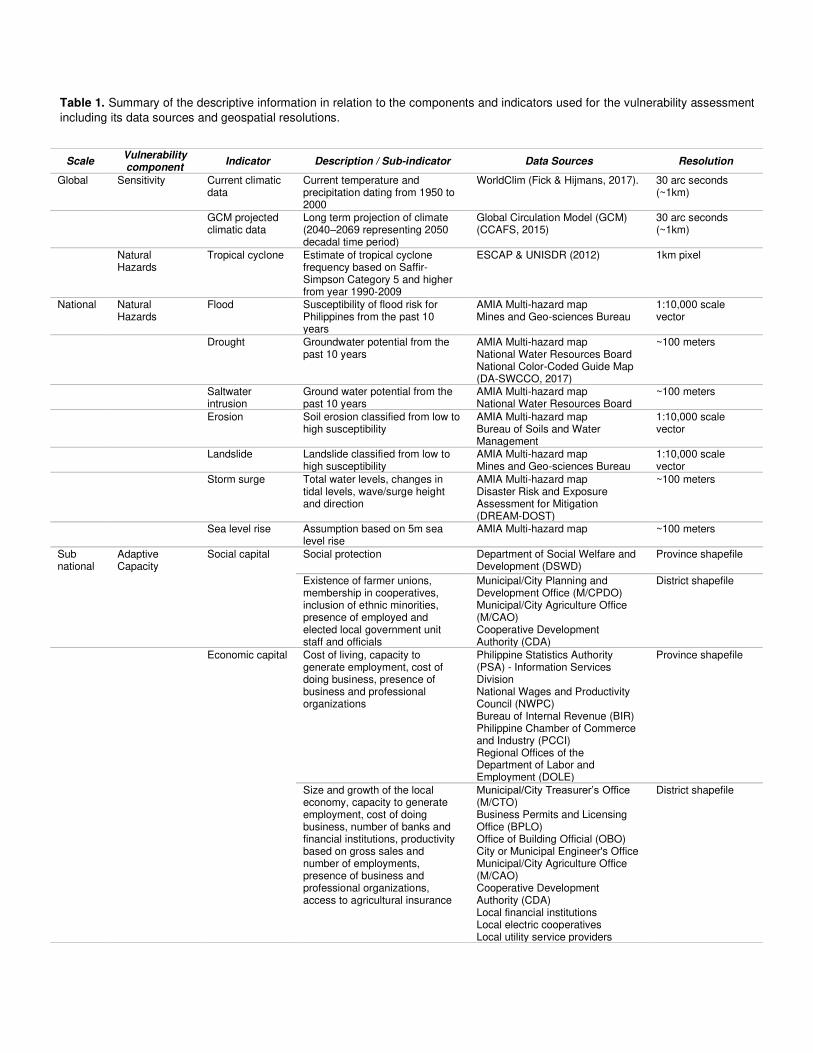
Table 1. Summary of the descriptive information in relation to the components and indicators used for the vulnerability assessment
including its data sources and geospatial resolutions.
Scale Vulnerability component
Indicator Description / Sub-indicator Data Sources Resolution
Global Sensitivity Current climatic data
Current temperature and precipitation dating from 1950 to 2000
WorldClim (Fick & Hijmans, 2017). 30 arc seconds (~1km)
GCM projected climatic data
Long term projection of climate (2040–2069 representing 2050 decadal time period)
Global Circulation Model (GCM) (CCAFS, 2015)
30 arc seconds (~1km)
Natural Hazards
Tropical cyclone Estimate of tropical cyclone frequency based on Saffir-Simpson Category 5 and higher from year 1990-2009
ESCAP & UNISDR (2012) 1km pixel
National Natural Hazards
Flood Susceptibility of flood risk for Philippines from the past 10 years
AMIA Multi-hazard map Mines and Geo-sciences Bureau
1:10,000 scale vector
Drought Groundwater potential from the past 10 years
AMIA Multi-hazard map National Water Resources Board National Color-Coded Guide Map (DA-SWCCO, 2017)
~100 meters
Saltwater intrusion
Ground water potential from the past 10 years
AMIA Multi-hazard map National Water Resources Board
~100 meters
Erosion Soil erosion classified from low to high susceptibility
AMIA Multi-hazard map Bureau of Soils and Water Management
1:10,000 scale vector
Landslide Landslide classified from low to high susceptibility
AMIA Multi-hazard map Mines and Geo-sciences Bureau
1:10,000 scale vector
Storm surge Total water levels, changes in tidal levels, wave/surge height and direction
AMIA Multi-hazard map Disaster Risk and Exposure Assessment for Mitigation (DREAM-DOST)
~100 meters
Sea level rise Assumption based on 5m sea level rise
AMIA Multi-hazard map ~100 meters
Sub national
Adaptive Capacity
Social capital Social protection Department of Social Welfare and Development (DSWD)
Province shapefile
Existence of farmer unions, membership in cooperatives, inclusion of ethnic minorities, presence of employed and elected local government unit staff and officials
Municipal/City Planning and Development Office (M/CPDO) Municipal/City Agriculture Office (M/CAO) Cooperative Development Authority (CDA)
District shapefile
Economic capital Cost of living, capacity to generate employment, cost of doing business, presence of business and professional organizations
Philippine Statistics Authority (PSA) - Information Services Division National Wages and Productivity Council (NWPC) Bureau of Internal Revenue (BIR) Philippine Chamber of Commerce and Industry (PCCI) Regional Offices of the Department of Labor and Employment (DOLE)
Province shapefile
Size and growth of the local economy, capacity to generate employment, cost of doing business, number of banks and financial institutions, productivity based on gross sales and number of employments, presence of business and professional organizations, access to agricultural insurance
Municipal/City Treasurer’s Office (M/CTO) Business Permits and Licensing Office (BPLO) Office of Building Official (OBO) City or Municipal Engineer's Office Municipal/City Agriculture Office (M/CAO) Cooperative Development Authority (CDA) Local financial institutions Local electric cooperatives Local utility service providers
District shapefile

Other accredited business organizations
Health capital Capacity of health services (public & private), presence of health infrastructures or facilities
Department of Health (DOH) Philippine Medical Association (PMA)
Province shapefile
Number of health manpower, presence of health infrastructures or facilities, access to water and sanitation, nutrition sufficiency
LGU Health Office City or Municipal Engineer's Office
District shapefile
Human capital Population, number of households, literacy rate, educational infrastructures, school enrolment, student-to-teacher ratio
Philippine Statistics Authority (PSA) Department of Education (DepEd) Division and Regional Offices Commission on Higher Education (CHED) Regional Office
Province shapefile
Institutional capital
Civil society organization programs, government response to calamities, presence of agricultural workers, conduct of climate resiliency field schools
Municipal/City Agriculture Office (M/CAO) Municipal/City DRRM Council (M/CDRRMC)
District shapefile
Natural capital Forest cover, access to irrigation systems and facilities, groundwater availability, presence of Marine Protected Area (MPA)
National Irrigation Authority (NIA) Department of Environment and Natural Resources (DENR)
Province shapefile
Physical capital Area vulnerable to hazards Mines and Geo-sciences Bureau Province shapefile
Land area, farm size, land tenure, value of livestock, poultry and aquaculture, number of farmers and fisherfolks, access to seeds, farm equipment, fertilizers and biologics, number of local farm machineries/facilities, access to post-harvest infrastructure and machineries, access to market outlets and facilities, access to fishing equipment
Municipal/City Agriculture Office (M/CAO) City or Municipal Engineer's Office
District shapefile
Anticipatory capital
Presence of functional MDRRMC, early warning systems, radio/TV stations, and telecommunications, access to communication technologies, presence of trainings or seminars related to DRRM, presence of Barangay Disaster Risk Reduction and Management Council (BDRRMC)
Barangay LGU Municipal/City DRRM Council (M/CDRRMC)
District shapefile

Figures
Figure 1
The Bicol River Basin a rea showing the eight major sub basins that constitutes its general geographicalcharacteristics. Note: The designations employed and the presentation of the material on this map do notimply the expression of any opinion whatsoever on the part of Research Square concerning the legalstatus of any country, territory, city or area or of its authorities, or concerning the delimitation of itsfrontiers or boundaries. This map has been provided by the authors.
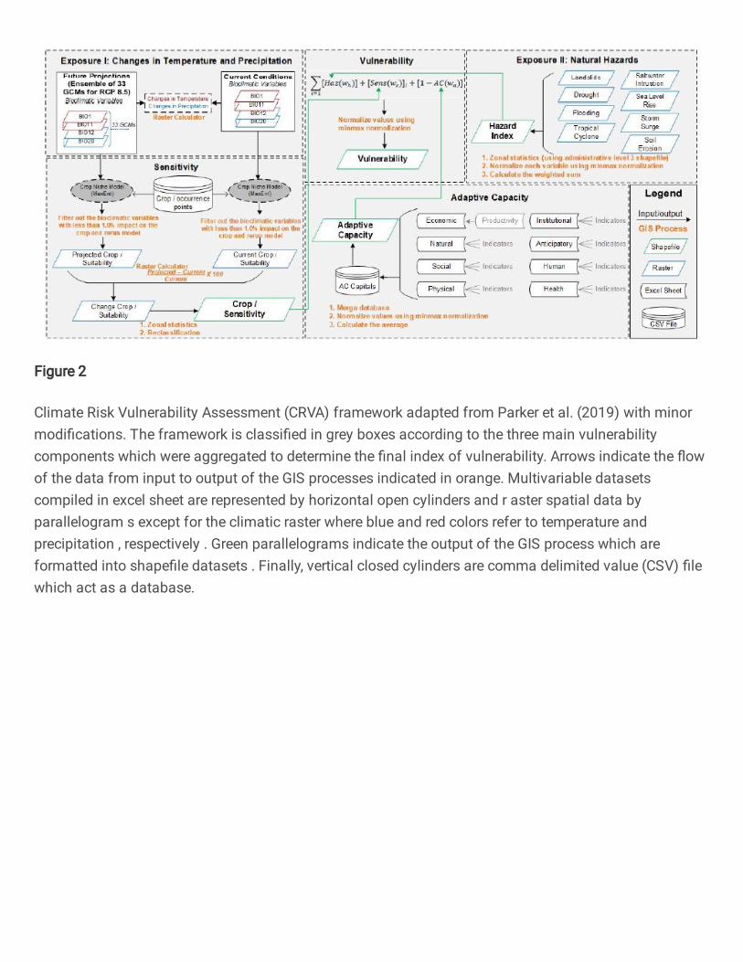
Figure 2
Climate Risk Vulnerability Assessment (CRVA) framework adapted from Parker et al. (2019) with minormodi�cations. The framework is classi�ed in grey boxes according to the three main vulnerabilitycomponents which were aggregated to determine the �nal index of vulnerability. Arrows indicate the �owof the data from input to output of the GIS processes indicated in orange. Multivariable datasetscompiled in excel sheet are represented by horizontal open cylinders and r aster spatial data byparallelogram s except for the climatic raster where blue and red colors refer to temperature andprecipitation , respectively . Green parallelograms indicate the output of the GIS process which areformatted into shape�le datasets . Finally, vertical closed cylinders are comma delimited value (CSV) �lewhich act as a database.

Figure 3
Species occurrence points of priority commodities that are principally cultivated with in the Bicol RiverBasin. Each crop is given corresponding color for visualization. Crop occurrences outside the BRB borderwas also depicted to facilitate comparison of the vegetation cove r within the area. Note: Thedesignations employed and the presentation of the material on this map do not imply the expression ofany opinion whatsoever on the part of Research Square concerning the legal status of any country,territory, city or area or of its authorities, or concerning the delimitation of its frontiers or boundaries. Thismap has been provided by the authors.

Figure 4
Vulnerability matrix representing stakeholders’ (N=330) perception towards vulnerability of the agriculturesector in terms of rural livelihoods versus the major hazards that is widely experienced in the Bicol RiverBasin. Results are expressed across a color gradient that represents the perceived magnitude of impactfrom crimson (signi�cant), light red (moderate), orange (minimal) to light yellow (no impact) followingthe Likert scale.
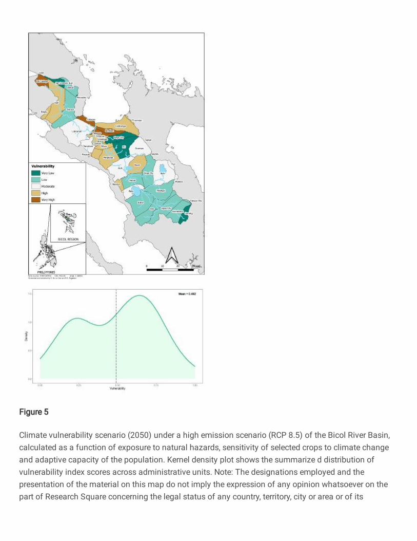
Figure 5
Climate vulnerability scenario (2050) under a high emission scenario (RCP 8.5) of the Bicol River Basin,calculated as a function of exposure to natural hazards, sensitivity of selected crops to climate changeand adaptive capacity of the population. Kernel density plot shows the summarize d distribution ofvulnerability index scores across administrative units. Note: The designations employed and thepresentation of the material on this map do not imply the expression of any opinion whatsoever on thepart of Research Square concerning the legal status of any country, territory, city or area or of its

authorities, or concerning the delimitation of its frontiers or boundaries. This map has been provided bythe authors.
Figure 6
Individual vulnerability component maps and kernel density plots showing the distribution of thevulnerability components: Exposure (left), Adaptive Capacity (middle), and Sensitivity (right). Note: Thedesignations employed and the presentation of the material on this map do not imply the expression ofany opinion whatsoever on the part of Research Square concerning the legal status of any country,territory, city or area or of its authorities, or concerning the delimitation of its frontiers or boundaries. Thismap has been provided by the authors.