Embed Size (px)
Citation preview
Department of Primary Industries and Water
Climate Change and Coastal Asset VulnerabilityAn audit of Tasmania’s coastal assets potentiallyvulnerable to flooding and sea-level rise.

Climate Change andCoastal Asset VulnerabilityAn audit of Tasmania’s coastal assets potentially
vulnerable to flooding and sea-level rise.
Published by theDepartment of Primary Industries
and Water, Tasmania
2008

DISCLAIMERThe information contained in this paper provides general information relating to risk managementapproaches to coastal hazards in Tasmania, as identified by various recent scientific studies. TheCrown in Right of the State of Tasmania, its officers, employees and agents do not accept liability,however arising, including liability for negligence, for any loss arising from the use or reliance upon
the content of this paper. No liability or responsibility is accepted for the consequences of anyinaccuracy in this paper, and persons relying upon it do so at their own risk absolutely.
© Government of TasmaniaThis work is copyright. It may be reproduced for study, research or training purposes subject to anacknowledgement of the source and no commercial usage or sale.
This document was developed as part of the Climate Change and Coastal Risk ManagementProject, Department of Primary Industries and Water, and supported by the Tasmanian RiskMitigation Programme coordinated by the Tasmanian State Emergency Service.
ISBN-13: Printed 978-0-7246-6445-0ISBN-13: PDF 978-0-7246-6446-7
Recommended citationDepartment of Primary Industries and Water (2008) Climate Change and Coastal AssetVulnerability: An audit of Tasmania’s coastal assets potentially vulnerable to flooding andsea-level rise. Department of Primary Industries and Water, Tasmania.
CONTACT DETAILS
Strategic Policy DivisionDepartment of Primary Industries and WaterGPO Box 44Hobart, TAS 7001
Ph (03) 6233 4031
www.dpiw.tas.gov.au/climatechange
ContentsIntroduction ........................................................................................................................................................ 1
Background.................................................................................................................................................... 1Objective........................................................................................................................................................ 1Application of Australian Standard ................................................................................................................ 1
Risk Assessment Methodology ......................................................................................................................... 2Assets included in the Risk Assessment ....................................................................................................... 2Hazards ......................................................................................................................................................... 5Vulnerability ................................................................................................................................................... 6Risks .............................................................................................................................................................. 6
Results of Risk Assessment .............................................................................................................................. 7Summary of Results ...................................................................................................................................... 7Priority focus areas ...................................................................................................................................... 11
Resource and tool development...................................................................................................................... 12Outline of proposed tools............................................................................................................................. 12Discussion of proposed tools....................................................................................................................... 17
Data/mapping of extreme sea-levels ....................................................................................................... 17Template risk assessment methodologies and plans.............................................................................. 17Case Study risk assessments and management plans........................................................................... 17General Tools .......................................................................................................................................... 17
Further research .............................................................................................................................................. 18Acknowledgments............................................................................................................................................ 21References ...................................................................................................................................................... 21Appendix A: Vulnerability Assessment Data – by Type .................................................................................. 22Appendix B: Vulnerability Assessment Data – by Municipality ....................................................................... 72

Page 1
Introduction
BackgroundThe Department of Primary Industries and Water initiated a Climate Change and Coastal RiskManagement Project in 2006. The Project is supported by the Tasmanian Risk Mitigation Programme,coordinated by the State Emergency Service.
The Project has three phases. The first phase is to develop detailed information on the probabilities ofstorm surges combined with sea-level rise, known as exceedance statistics, for use in risk planningand management. The second phase considers the coastal assets and values vulnerable to stormsurge flooding at current and projected sea-levels. The third phase is focussed on using theinformation developed in the first two phases to direct Project resources to the highest priority areasso that relevant and effective tools and resources can be developed to support improved riskmanagement of assets and values in Tasmania’s coastal zone.
This Report has been been produced as part of the Project’s second phase, and outlines a desktopaudit undertaken on assets and values potentially at risk in the Tasmanian coastal zone. The desktopaudit identifies sites (by a broad class of asset and by local government area) which appear vulnerableto erosion and flooding impacts. However, limitations in the availability of Statewide data for someasset types prevented their inclusion in this study.
ObjectiveThe coastal zone is vulnerable to the impacts of natural hazards such as storm surge and erosion.Climate change and sea-level rise will exacerbate the impacts of these hazards, causing progressiveflooding and erosion of shorelines. Information on the potential vulnerability to these hazards is criticalto the development of planning, mitigation and management responses that are appropriate, andbased in sound risk management techniques.
The objective of this report is to support the identification of assets most vulnerable to storm-surge,erosion and sea-level rise impacts, and the broad tools and resources that will be needed to supportimproved coastal risk management in Tasmania.
Application of Australian StandardAustralian Standard AAS/NZS 4360:2004 “…provides a generic framework for establishing thecontext, identifying, analysing, evaluating, treating, monitoring and communicating risk.”
The Standard has been adopted throughout Australia, and notably by Emergency ManagementAustralia and the Tasmanian State Disaster Committee. The Standard provides the foundation for theClimate Change and Coastal Risk Management Project, with the Project outputs designed to meet therequirements of the Standard.
The Standard defines a risk as ‘the possibility of something happening that impacts on your objectives.It is the chance to either make a gain or loss. It is measured in terms of likelihood and consequence.’
Key Definitions drawn from the Standard include:Consequence outcome or impact of an event.
Notes:There can be more than one consequence from one event.Consequences can range from positive to negative.Consequences can be expressed qualitatively or quantitatively.Consequences are considered in relation to the achievement of objectives.
Event occurrence of a particular set of circumstancesNote: The event can be certain or uncertain, and the event can be a singleoccurrence or a series of occurrences.
Hazard a source of potential harmLikelihood used as a general description of probability or frequency.
Note: Can be expressed qualitatively or quantitatively.

Page 2
Risk the chance of something happening that will have an impact on objectivesNotes:A risk is often specified in terms of an event or circumstance and theconsequences that may flow from it.Risk is measured in terms of a combination of the consequences of an event andtheir likelihood.Risk may have a positive or negative impact.
Risk assessment the overall process of risk identification, risk analysis and risk evaluation,including:• Establishing the context (eg organisation structures and risk management
policies);• Identifying the risks (ie what can happen, when, where and why);• Analysing the risks (including determining consequences and likelihood to
determine the level of risk);• Evaluating the risks (including deciding whether to treat the risks or not); and• Treating the risksEach step above requires communication and consultation, and also monitoringand review.
Risk Assessment Methodology
Assets included in the Risk AssessmentAssets used in this desktop audit were sourced from existing digital data from a number of sources.No new data collection was undertaken. Table 1 outlines the assets and values considered.
Data used included:• Land tenure (source: Resource Management and Conservation Division, DPIW, though State of
the Environment Reporting, Resource Planning and Development Commission)• The LIST layers (source: Information and Land Services Division, DPIW, though State of the
Environment Reporting, Resource Planning and Development Commission)• Community Facilities• Roads
• The Parks and Wildlife Service asset management register (source: Parks and Wildlife Service,Department of Tourism, Arts and the Environment)
• Environmentally Relevant Land Use Register (ERLUR) (source: Environment Division,Department of Tourism, Arts and the Environment).
The data collected as part of the Crown Land Services Marine Structures Review Project was notanalysed as most of those structures are on the water side of the hazard zones used in this analysis(see the section ‘Risk Assessment’ for further details of the analysis methodology). That Project has asignificantly better understanding of the condition and vulnerability of those structures than could beobtained from the indicative analysis used here.
The risk assessment considered Historic Sites, as represented by land tenure. Data was not availableto consider in the spatial analysis items on the Heritage Register, so the land tenure for which datawas available was used as a surrogate. While this was in part a limitation, it did provide recognition ofthe importance of surrounding ‘lands’ to the historic value and context of the particular item(s) forwhich the land was reserved.
Issues with data availability prevented a number of other asset types from being included in thisdesktop analysis. Of particular note are sewage pipes and pumping stations. As the most low lyingparts of the sewage infrastructure, these are potentially vulnerable, which could cause major pollutionevents and are expensive to replace. They were not included in the desktop GIS analysis as aconsistent, Statewide dataset of all elements was not readily available. The analysis did include arange of sewage and waste water treatment plants, however it is recognised that this is a significantunderstatement of the potential risks.
Likewise, comprehensive Statewide spatial datasets were not available, or readily accessible, forAboriginal cultural heritage sites, stormwater infrastructure, land-based boating and aircraft

Page 3
navigational infrastructure, electricity and communications facilities, and seawalls and other protectiveinfrastructure.
The analysis did consider ‘private’ land, which includes residential, commercial and industrial areas.Individual parcels were not analysed given the magnitude of this task and the diversity of developmentaround the State. In addition, it is more appropriate to address development on private land throughplanning schemes than through individual risk management plans, which is the focus of this Project.The section ‘Priority focus areas’ (page 11) provides further details.
Further detailed analysis, often for specific locations, would be required to address the limitations ofthe analysis undertaken for this Project.
Table 1 Summary of assets and values considered
Asset TypeLand tenure (area)Commonwealth Land Land administered by the Commonwealth, including DefenceHistorical Sites Land classed as Historic Site under the National Parks and Reserve
Management Act 2002Natural Reserves Land reserved for primarily natural reasons under the National
Parks and Reserve Management Act 2002, Crown Lands Act 1976,and Forestry Act 1920.
Other Public Land Public land administered by a public agency or authority (State orLocal), but not as a formal reserve for natural reasons, State Forestor private reserve.
Private Reserves Formal private reserves under the National Parks and ReserveManagement Act 2002
State Forest Land defined as State Forest under the Forestry Act 1920Unreserved Private Private landFacilities (number)Boating & Surf Life Clubs Rowing, Surf life saving and Yacht and sailing clubsBurial Sites A cemeteryCamping Ground/Caravan Park Camps, Camping Ground and Caravan ParksCar Park A public car parkChurch A place used for religious purposes by a particular sectCommunity Care A non-government establishment that provides
accommodation, care or support to those in needHall/Community Centre A hall or community centre belonging to a particular community,
council, group or organisation.Cultural Area A cultural featureHistorical A historical featureLibraries A place containing an organised collection of literary material,
films, recordings, music, or other documents. Excludes privatevideo library
Medical Services A public or private establishment, other than a private medicalor para-medical practice, that provides treatment, care,accommodation or insurance for the ill or injured
Museums/Galleries Gallery - A place for exhibiting works of art and craft.Museum - A place for keeping, exhibiting and studying objectsof scientific, artistic, and historical interest.
Natural A natural featurePark/Reserve A small public ground for informal, outdoor recreation belonging
to and/or maintained by a Council or community organisationPicnic Area A public amenity providing basic cooking or picnic facilitiesSchools An establishment for formal instruction. (But excluding
university sites)Scout/Girl Guide A meeting place of a scouting organisation or Guides TasmaniaSenior/Elderly Citizens A meeting place of a club for senior and elderly citizensService Station A retail fuel outletSports Building Building for Indoor cricket, Squash, for more than one sport,
Swimming pools or a facility for any other particular sport

Page 4
Sports Clubs A meeting place of any type of sporting club, including Bowls,Cricket, Croquet, Football, Golf, Gun and rifle, Rugby, Soccer,Tennis or Other sporting club
Sports Grounds A ground used for a variety of sports, usually havinggrandstands for spectators and facilities for players.
State Police/EmergencyManagement Services
An establishment for an operational unit or service of a Tasmaniangovernment police or emergency service (but not a headquarters oradministration unit). This may not include designated emergencyservice centres such as coordination, evacuation or recoverycentres.
Sewage Treatment and WasterWater plants
Sites in the LIST Community Services layer that include ‘sewage’ or‘wastewater’ in their description, and including lagoons, plants andworks. This does not include the sewage pipe network, nor thepumping stations at the low points along the sewage pipelines.
Roads (km)National/State Highway Roads which are of importance in a national sense, and/or are a
major intrastate through route, and/or are principal connector roadsbetween Capitals and/or major regions and/or key towns
Arterial Road A road that predominantly carries traffic from one region to another,forming a principal avenue of communication for traffic movements
Feeder Commonly used roads that service urban networks, and/or ruralcommunities, and/or resource areas. Normally connects accessroads to higher classification roads
Access Road Public or private road providing access to local properties,resources, facilities, or minor tourism destinations
Vehicular Track Rougher roads, usually unpaved, for vehicular trafficPWS assets (number)PWS Major Buildings Houses, accommodation buildings and visitor centresPWS Minor Buildings Shelters, information booths, stores, workshops, walker
accommodation hutsPWS Camping Areas Camp sites (informal and defined)PWS Car Park Car park (formed and informal)PWS Coastal Infrastructure Boat ramps, slips and minor jettiesPWS Picnic Areas or Facilities Sites with barbeques and/or picnic tablesPWS Toilet Toilets (including septic, pit, contained)PWS Track Infrastructure Including bridges, walkways, duckboarding, and viewing platformsPWS Road Infrastructure Includes barriers, bridges and cattle gridsPWS Track (km in reserves) Track for walkersPWS Road (km in reserves) Roads for vehiclesEnvironmental permit sitesWaste disposal sites Sites for the disposal of waste, including both operating and closed
sites. Does not include waste transfer stations.Storage tanks or facility Tanks or facilities storing materials such as explosives, gas and
chemicals, either above or below ground.
Each asset was also analysed by Local Government area, and for the State as a whole. There are 24municipal areas in the State that include at least a small proportion of coastline, or an estuarinesystem that is significantly affected by tidal and storm surge influences.

Page 5
Table 2 Tasmanian coastal Councils
Coastal CouncilBreak O'Day Council Glenorchy City CouncilBrighton Council Hobart City CouncilBurnie City Council Huon Valley CouncilCentral Coast Council Kingborough CouncilCircular Head Council King Island CouncilClarence City Council Latrobe CouncilDerwent Valley Council Launceston City CouncilDevonport City Council SorellDorset Council Tasman CouncilFlinders Council Waratah/Wynyard CouncilGeorge Town Council West Coast CouncilGlamorgan/Spring Bay Council West Tamar Council
The details of the assessment of each asset type against each coastal municipality is provided inAppendix A. The details of all the assets for each of the municipalities are provided in Appendix B.
HazardsThe threats to assets were identified using four flood hazard zones. Three were identified in Sharples(2006) who mapped the likely storm surge inundation zones using historically recorded storm surgeevents, and examined the increase in the hazard zone under climate change scenarios. A fourth zoneutilised a buffer of a further 50m inland.
The inundation zones used in Sharples correspond to indicative coastal areas potentially susceptibleto flooding in a 0.01% exceedance storm-surge event, which corresponds to a return period ofapproximately 2 years (for further details, see Sharples (2006) section 4.3.2, pp78–88). While thislevel of hazard is different to the 1% annual exceedance level used in most regulatory standards forrisk management, it provided the most useful Statewide assessment of the potential hazard area thatwas available at the time of the analysis.
The sea-level rise scenarios used by Sharples were based on the Intergovernmental Panel on ClimateChange (IPCC) Third Assessment Report (2001). At the time of the analysis by Sharples, the FourthAssessment Report had not been released. To identify the spectrum of risk from potential sea-levelrise, the two extremes of the sea-level rise scenarios were used to add to the current levels of stormsurge hazard. The IPCC’s low scenario of +9cm and the high scenario of +88cm are calculated from1990 sea-levels, so these were adjusted in Sharples for the 2004 baseline being used. Hence,Sharples used projections of global average sea-level rise between 2004 and 2100 of 8cm and 84cmrespectively (Sharples 2006, p81).
As an additional mechanism for assessing the hazard from sea-level rise and storm surge, a further50 metre buffer was added inland of the high sea-level rise projection. This was done for two reasons.Firstly, such a buffer recognises that the digital representations of the assets being considered wasnot always accurate, as some assets are represented in the digital datasets as a single point, whereasthey can actually physically take up an area of some distance around the central location point.Hence, an asset with a point location just outside a hazard zone, may actually also occur in the hazardzone. Secondly, some of the assets analysed also have infrastructure associated with them that wouldbe vulnerable to these hazards, but which are not represented in the digital data used for the analysis.Therefore, using a 50m buffer gave an additional zone of lower risk, but with still some potential risk.
A known limitation of the method used to assess vulnerability is that the mapping of the hazard zonesis based on the high water mark, and therefore does not identify those assets in the intertidal zone, orwhich span estuarine areas. An initial analysis of the impact of this limitation suggested that therewere not many examples of the assets being considered that would be missed. This does highlight,however, that the analysis has produced an indicative level of vulnerability, and that detailed localassessments will be necessary for local planning authorities to fully assess the risks to the assets andvalues they manage.

Page 6
Another perspective that was not able to be assessed with the data available (including Sharples’(2006) mapping) was the depth or duration of flooding in the various hazard zones. The mapping ofthe hazard zones available – and used in this analysis – only provided information on the changes tothe inland extent of flooding. It would stand to reason that the areas currently vulnerable to floodingwould be inundated more frequently, to a greater depth, and for longer, as sea-levels rise and theflooding zone extends inland.
In summary, the four flood hazard zones used in this audit were:• “2004 hazard” = indicative coastal areas potentially susceptible to flooding under 2004 sea-level
conditions;• “low 2100 hazard” = indicative coastal areas potentially susceptible to flooding with a low sea-level
rise scenario (2004 level + 8cm);• “high 2100 hazard” = indicative coastal areas potentially susceptible to flooding with a high sea-
level rise scenario (2004 level + 84cm); and• “cautionary 50m buffer” = indicative zone of 50m inland of the high sea-level rise scenario.
VulnerabilityVulnerability was identified by assessing the broad type of assets included in each of the assessmentcategories, and applying an ‘average’, or ‘typical’, level of susceptibility of that type of asset to floodingand erosion impacts caused by storm surge and sea-level rise.
The assessment outlines the level of consequence that such hazards have on the various types ofassets. Vulnerability considers a range of environmental, social and economic factors. Environmentalfactors can include salt contamination of soils from flooding, erosion of beach and dune systems, lossof vegetation and damage to habitats, including the loss of threatened species. Social factors caninclude disruption to the use of the asset, and loss of amenity. Economic factors can include issuessuch as physical damage or corrosion to built structures, the undermining of foundations, and damageto building contents from being flooded.
Other issues such as emergency services are also considered, for example, the disruption to criticaltransport routes due to flooding events. A road subject to significant flooding during an extreme sea-level event is highly vulnerable if it is the only access route to an area. An area that is cut off makes itmore difficult to provide critical services, such as fire and ambulance, during those events.
Another example is the category of “Community and Public Buildings”. These can be highly vulnerableas flooding and/or erosion can physically damage the structure or foundations, which in turn is likely tohave a significant economic cost to repair. It would also have a social cost as such structures are oftenfocal points for local communities, and any disruption to their use – either during an extreme sea-levelevent or afterwards as it is repaired – could be a considerable negative to the community.
Hence the assessment in Table 4 provides an indicative summary of the likely vulnerability of each ofthe significant categories, highlighting particular aspects where relevant.
The vulnerability assessment primarily considers short to medium term impacts on public orcommunity assets and infrastructure. The consideration of longer-term adjustment issues wouldrequire further assessments to be undertaken. Longer term human health and welfare issues werealso beyond the scope of this analysis.
RisksA risk exists when there is a combination of the presence of a hazard (or threat), the likelihood ofoccurrence, a vulnerability to that hazard, and therefore a consequential impact.
A preliminary assessment of the risk faced by the range of categories used in this analysis has beenprovided in Table 4 to assist with identifying priority tools and resources to be developed in the latterpart of the Climate Change and Coastal Risk Management Project.
The process for assessing a level of risk incorporated the amount of the asset likely to be affected at2004 sea-levels, and the increase at higher sea-level rise projections. It also considered thevulnerability – or consequence of impact – of each of the categories to the hazard of storm surge andsea-level rise.
Page 7
These elements were considered jointly, allowing for a qualitative assessment of the indicative level ofrisk for that category. This can then be used to prioritise future action to mitigate the increasing risksfaced from storm surge and coastal erosion.
Results of Risk Assessment
Summary of ResultsThe details of the assets considered and the hazard zones they occur in are provided in Appendix A.A breakdown of assets by municipality is provided in Appendix B.
A summary of the assets considered and their Statewide totals are provided in Table 3. As notedabove, there are also other categories of assets that were not able to be considered as consistentStatewide data was not readily accessible for this desktop analysis.
It should be noted that the audit primarily considers short to medium term impacts on public orcommunity assets and infrastructure. The consideration of longer term adjustment issues wouldrequire further assessments to be undertaken. Longer term human health and welfare issues werealso beyond the scope of the analysis.
The desktop audit highlights that there are a number of values and types of assets around Tasmania’scoastline that are in the current hazard zone and/or register in the potential hazard zones. These typesof values and assets are vulnerable to the impacts of storm-surge and sea-level rise, with there beingparticular concern for:
• the area of natural reserves, especially in the Circular Head, Flinders and Huon municipalities(Table 7);
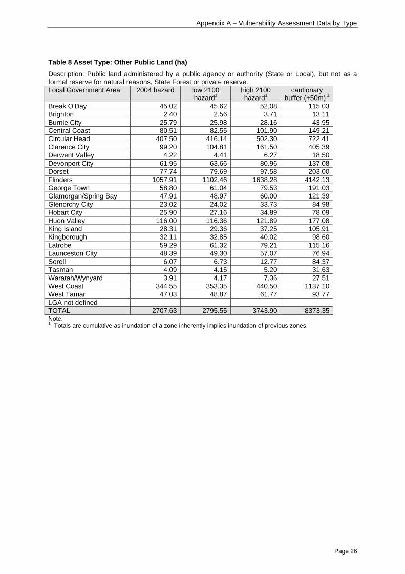
• the area of other public land (State and Local Government), predominantly in the Flinders, CircularHead and West Coast municipalities (Table 8);
• the area of unreserved private land, especially in the Circular Head, Flinders, Glamorgan/SpringBay and West Tamar municipalities (Table 11);
• Community/Public buildings including Community Care, Hall/Community Centre, Sports Building,Sports Clubs, particularly in the north, east and south of the State (Table 17, Table 18, Table 31,and Table 32);
• Picnic areas, both inside and outside reserves, especially in the Break O’Day, Central Coast,Clarence, Glamorgan/Spring Bay, Kingborough, West Tamar and Latrobe municipalities (Table 26and Table 46);
• Schools in the Circular Head, Break O’Day and Launceston municipalities (Table 27);
• Service stations particularly in the north, east and south of the State (Table 30);
• Emergency services buildings especially in the Break O’Day, Glamorgan/Spring Bay and CircularHead municipalities. Clarence, Kingborough and Flinders also register in the potential hazardzones (Table 34). (Note that designated emergency service centres such as coordination,evacuation or recovery centres were generally not included in the analysis, hence further workwould be required to identify these sites);
• Sewage and wastewater treatment plants, especially in the north of the State (Table 35). (Notethat sewage pipes and pumping stations were not able to be assessed, however it is recognisedthat these are important vulnerable points of the total sewage infrastructure);
• Major State highways and arterial roads in many areas around the State (Table 36 and Table 37);

Page 8
• Access roads, where Local Governments are primarily responsible, especially in the north, north-west and south-east of the State (Table 39);
• Major buildings under the jurisdiction of the Parks and Wildlife Service, especially in George Townand West Coast municipalities (Table 41);
• Toilets managed by the Parks and Wildlife Service especially in the east, north-east and south-east of the State (Table 47);
• Waste disposal sites, mainly in the north-west, though there are also some potential issues in thesouth-east (Table 52);
• Storage tanks and facilities, especially in the north of the State, though throughout the State underhigher sea-level rise scenarios (Table 53).
Management responsibilities for the assets at risk are spread between Local and State Government,with the Commonwealth also having some responsibilities.
Table 3 Summary of asset vulnerability
Asset Type 2004hazard
low 2100hazard1
high 2100hazard1
cautionarybuffer (+50m) 1
Land tenure (ha)Commonwealth Land 22 24 40 123Historical Sites 114 119 163 757Natural Reserves 9,137 9,462 12,854 37,941Other Public Land 2,707 2,795 3,743 8,373Private Reserves 571 584 692 997State Forest 140 142 169 427Unreserved Private 10,557 10,892 14,588 23,528Facilities (number)Boating & Surf Life Clubs 21 21 27 53Burial Sites 2 2 3 8Camping Ground/Caravan Park 16 16 21 37Car Park 6 6 7 10Church 9 9 14 22Community Care 13 13 16 25Hall/Community Centre 9 9 10 28Cultural Area 0 0 7 12Historical 2 2 2 11Libraries 1 1 2 2Medical Services 5 5 8 13Museums/Galleries 3 3 3 12Natural 2 2 2 7Park/Reserve 35 35 54 92Picnic Area 65 65 79 122Schools 4 4 6 12Scout/Girl Guide 9 9 10 17Senior/Elderly Citizens 1 1 3 4Service Station 13 13 15 38Sports Building 14 14 16 48Sports Clubs 27 27 35 63Sports Grounds 3 3 6 11State Police/Emergency Management
Services10 10 11 32
Sewage and wastewater treatment 9 9 12 22Roads (km)National/State Highway 31 32 47 140Arterial Road 42 43 56 111Feeder 21 22 32 91Access Road 247 251 339 706Vehicular Track 139 145 211 437

Page 9
PWS assets (number)PWS Major Buildings 11 11 13 21PWS Minor Buildings 29 29 34 55PWS Camping Areas 13 13 22 54PWS Car Park 21 25 33 72PWS Coastal Infrastructure 12 12 14 17PWS Picnic Areas or Facilities 87 90 128 204PWS Toilet 41 41 61 129PWS Track Infrastructure 12 12 17 44PWS Road Infrastructure 13 13 22 43PWS Track (km in reserves) 35 36 58 169PWS Road (km in reserves) 11 12 16 20Environmental permit sites (number)Waste disposal sites 4 4 5 6Storage tanks or facility 24 24 36 67Note:1 Totals are cumulative as inundation of a zone inherently implies inundation of previous zones.
Table 4 outlines the assets most significantly impacted together with a preliminary risk assessmentand potential responses. The Amount/Likelihood column is derived from Table 3 above. The processfor determining Vulnerability and Risk is provided in the previous section, “Risk AssessmentMethodology”. An outline of the focus of the likely necessary response is provided in the final columnof Table 4.
For the assets reviewed (Table 3) but not addressed in the risk assessment (Table 4), it wasconsidered that the amount or likelihood of impact, and/or the low level of consequences of thatimpact meant that it should not be a priority for the project. Details of these assets are included inAppendix A: Vulnerability Assessment Data – by Type, and Appendix B: Vulnerability AssessmentData – by Municipality.
Table 4 Preliminary risk assessment of major assets and proposed responses
Asset type Amount/likelihoodof impact 1
Vulnerability Risk Response focus
Unreserved Privateland
2004 hazard – alarge area(10,557ha)*High SLR –potentially verylarge area (up to23,528ha)
Potentially high High –dependingon level ofdevelopment
Depends oninfrastructure/development
Natural Reserves 2004 hazard – alarge area(9,138ha)High SLR –potentially a verylarge area (up to37,942ha)
High impact onnatural/conservationvalues
High Specific coastalvulnerability inputinto natural areamanagementplanning
Other Public Land 2004 hazard – animportant area(2,708ha)High SLR –potentially a largearea (up to8,373ha)
Important area.Often high valueto localcommunity
Moderate General riskmanagementplanning
Community andpublic buildings
2004 hazard– 63High SLR –potentially up to164, a significantnumber
Usually high valueto localcommunity
Moderate General riskmanagementplanning (Note:lifespan may be lessthan high SLRtimeframe)
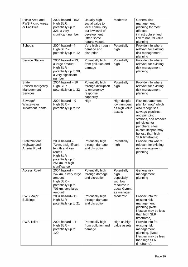
Page 10
Picnic Area andPWS Picnic Areasor Facilities
2004 hazard– 152High SLR –potentially up to326, a verysignificant number
Usually highsocial value tolocal communitybut low level ofdevelopment.Often somenatural values.
Moderate General riskmanagementplanning for mostaffectedinfrastructure, andlink to natural valueplanning
Schools 2004 hazard– 4High SLR –potentially up to 12
Very high throughdamage anddisruption
Potentiallyhigh
Provide info whererelevant for existingrisk managementplanning
Service Station 2004 hazard – 13,a large amountHigh SLR –potentially up to 38,a very significantnumber
Potentially highfrom pollution anddamage
Potentiallyhigh
Provide info whererelevant for existingrisk managementplanning
StatePolice/EmergencyManagementServices
2004 hazard – 10High SLR –potentially up to 32
Potentially highthrough disruptionto emergencyresponsecapability
Potentiallyhigh
Provide info whererelevant for existingrisk managementplanning
Sewage/WastewaterTreatment Plants
2004 hazard – 9High SLR –potentially up to 22
High High despitelow numbersas high valueassets
Risk managementplan for ‘now’ whichalso recognisessewage pipelinesand pumpingstations, and broaderprinciples forperipheral sites(Note: lifespan maybe less than highSLR timeframe)
State/NationalHighway andArterial Road
2004 hazard –73km, a significantlength and keyroutes.High SLR –potentially up to251km, of highsignificance
Potentially highthrough damageand disruption
Potentiallyhigh
Provide info whererelevant for existingrisk managementplanning
Access Road 2004 hazard –247km, a very largeamountHigh SLR –potentially up to706km, very largeamount
Potentially highthrough damageand disruption
Potentiallyhigh,especiallywith lowresource inLocal Gvmntas manager
General riskmanagementplanning
PWS MajorBuildings
2004 hazard– 11High SLR –potentially up to 21
Potentially highthrough damageand disruption
Moderate Provide info forexisting riskmanagementplanning (Note:lifespan may be lessthan high SLRtimeframe).
PWS Toilet 2004 hazard – 41High SLR –potentially up to129
Potentially highfrom pollution anddamage
High as highvalue assets
Provide info forexisting riskmanagementplanning. (Note:lifespan may be lessthan high SLRtimeframe).

Page 11
Waste disposalsites
2004 hazard – 4High SLR –potentially up to 6
Potentially highfrom pollution
High despitelow numbersas high valueassets
Provide info forexisting riskmanagementplanning
Storage tanks orfacility
2004 hazard – 24High SLR –potentially up to 67
Potentially highfrom pollution anddamage
Moderate toHigh
Provide info forexisting riskmanagementplanning
Note:1 High SLR refers to “high 2100 hazard” and “cautionary buffer (+50m)”.
Priority focus areasThe desktop audit provides a significantly better understanding of the types of assets at greatest riskfrom storm-surge and sea-level rise, and the regions in which they occur. The purpose of such ananalysis was to provide a more quantitative mechanism for prioritising future risk assessment andmanagement work.
From the Summary of Results above, it is clear that further work will need to address a number ofareas. The areas requiring particular attention include (in no priority order):1) Reserves for generally natural purposes;2) Large community and public buildings, including:
a) Community Care facilities;b) Hall/Community Centres;c) Sports Building;d) Sports Clubs;
3) Picnic areas and facilities, both inside and outside formal reserve areas;4) Schools;5) Service Stations;6) Emergency services buildings;7) Sewage and wastewater treatment plants (including associated pipelines and pumping stations);8) Roads – especially local (access) roads;9) PWS infrastructure, especially major buildings and toilets;10) Waste disposal sites;11) Storage tanks and facilities.
Further details of the other categories assessed but not listed are provided below.
Private Land and Other Public Land has not been listed as a specific Project focus area as the risksare dependent on the type of development and infrastructure present. Private land can range from nodevelopment at all, in which case the consequence of impacts is probably generally restricted tophysical erosion, through to significantly developed where the consequences of impact are very high.Given this diversity of potential impact, it is expected that the most appropriate way to deal with thiscategory is through appropriate and consistent planning and development standards, implementedthrough Local Government planning schemes. Hence, a focus area of the Project will include liaisonwith the relevant planning bodies to assist in the development of appropriate methods for defining risk,and appropriate development standards to apply for the different levels of risk around the Tasmaniancoastline. Wherever possible, the Project will work with existing processes and structures to ensurethat standard planning process are provided with the best information and guidance on the mostappropriate methodologies to apply to determine, asses and mitigate risks from storm surge floodingand sea-level rise.
Historic Sites have also not been listed, as further examination of the types of assets and valuescovered by this category is required to better understand the vulnerabilities, or the consequences,before the level of risk can be assessed. This is required before an assessment can be made of themost effective tools and resources required. It is possible that with the existence of an already matureplanning and management system, the provision of information as for the natural reserves listedabove will be the best form of ‘support’ that this Project is able to provide.

Page 12
While there are many parts of the State that are impacted, the north-west, and east coast regionshave particularly high concentrations of assets vulnerable to sea-level rise and flooding.
To address the issues above, further liaison with some key stakeholders will be required before thenature of the most effective ‘tools’ and ‘resources’ can be determined. While some stakeholders mayrequire assistance to develop fully developed risk management plans, other stakeholders may onlyneed further technical advice on storm surge and sea-level rise exceedance probabilities for them toincorporate into their own existing management systems.
The key stakeholders for helping guide the tool and resource development process include:• Parks and Wildlife Service, Department of Tourism, Arts and the Environment – for natural area
planning and infrastructure management planning (including major buildings, toilets and picnicareas), and also types of historic ‘values’ in the hazard zones;
• Environment Division, Department of Tourism, Arts and the Environment – for locating andpermitting activities such as service stations, waste disposal and storage facilities;
• Local Government – for community buildings, local (natural) parks and picnic areas and facilities,road management and general hazard zoning.
• State Emergency Service – for emergency response capabilities from coordination centres inhazard zones, and also disruption to transport lines during emergencies;
• Department of Infrastructure, Energy and Resources – for road planning requirements;• Department of Education – for infrastructure management and emergency response planning.
Resource and tool development
Outline of proposed toolsThere are a number of areas that arise from the asset vulnerability analysis that will need further workto improve risk management planning. Some will be a priority for the Climate Change and CoastalRisk Management Project, others will require work to be done through other activities and programs.
Below is an outline of the major categories of assets identified, and a description of the risks thatincludes the level of vulnerability, or degree of consequence, on the value of those assets.
The priority focus areas are also indicated based on the level of risk. These have been developed toassist in guiding the work of the Climate Change and Coastal Risk Management Project. The termsused are:• ‘Primary’ – refers to those categories where significant tool development is required; and• ‘Secondary’ – refers to those categories for which the main response will be to provide information
to another organisation for them to incorporate into their existing planning and managementsystem.
The following also outlines the likely range of tools and resources required to improve riskmanagement in the coastal zone. The term “tool” is used to refer to a range of products includinginformation papers, mapping, template management plans, detailed management plans, data and soon.
There are a number of policy approaches that these tools can work to achieve. Previous studies haveshown that strategic management of hazards requires full consideration of the risks, and the costs andbenefits of response actions. This analysis has been aimed at assisting the Climate Change andCoastal Risk Management Project to develop tools that take a risk management approach, andtherefore consider strategic aims, to ensure planning and management approaches will be effective.To guide the development of tools, the adaptive decision-making framework and indicative policyresponse options detailed in Rigby (2005) were considered. Such policy responses include:• Abandon (allow natural processes to continue unabated);• Protect (shield areas from relevant climate change impacts and identified hazards);• Adapt (formulate measures that allow continued or extended use of vulnerable land and
resources);• Retreat, including phased retreat (instigate measures to minimise the costs of changing land-use
once threatened by coastal hazards and climate change impacts).

Page 13
As noted previously, an important category not detailed here is private land. With such diversity ofdevelopment on private land, it is not possible for a specific project such as the Climate Change andCoastal Risk Management Project to develop specific tools to cover the broad range of possibilities. Itwould be more effective for the Project to work with those areas in Government that are alsodeveloping general planning and development standards. This is discussed in more detail in thefollowing sections.
Another category that has not been addressed specifically but which still covers important values arehistoric sites and historic buildings. Their management is likely to have a number of similarities toseveral of the other categories, and the managing authorities are generally already covered. It isproposed that relevant information is provided to appropriate management authorities as part of theother discussions planned.
It is also a known limitation of the analysis that there were some categories of asset and infrastructurethat could not be included, as consistent datasets for the whole State were not readily available.These include: sewage pipes and pumping stations; Aboriginal cultural heritage sites; stormwaterinfrastructure; land-based boating and aircraft navigational infrastructure; electricity andcommunications facilities; and seawalls and other protective infrastructure.
Category: Reserves (for natural purposes)
Assets included: land reserved for primarily natural purposes under the National Parks and ReserveManagement Act 2002, Crown Lands Act 1976 and Forestry Act 1920, other ‘natural parks’ and‘park/reserves’ with less formal status and usually managed locally.
Risks: Not only is there a large area susceptible, most of these areas contain high natural values (eghigh conservation value vegetation types and geomorphic features, and threatened species).They are often also highly valued social assets.
Project focus area: Secondary
“Tools” required: Provide foundation information to incorporate into existing PWS planning andmanagement system, and some tool development for more local level natural reserves:- Data/mapping on extreme sea-levels- Template risk assessment methodologies and plans- Case study risk assessment and management plan
Major Stakeholders: Parks and Wildlife Service, Local Government, Resource Management andConservation Division, and Natural Resource Management groups.
Category: Large Community and Public Buildings
Assets included: Significant community buildings with often items or equipment of significant value thatmay not be easily removed. Buildings include Community Care facilities, Hall/CommunityCentres, Sports Building and Sports Clubs.
Risks: While some of these large buildings may be able to withstand periodic flooding, and thedisruption to services may not be highly critical, some structural damage is likely and clean upcosts are likely to stretch generally tight budgets. Such facilities are generally strong focal pointsfor local communities, resulting in high social impacts. Some facilities may also serve as focalpoints during emergencies, so their placement in a hazard zone may need consideration.
Project focus area: Primary
“Tools” required: Will need further liaison with Local Government and targeted service providers, butlikely to include:- Data/mapping on extreme sea-levels- Template risk assessment methodologies and plans- Case study risk assessment and management plan
Major Stakeholders: Local Government, Health and Human Services.
Page 14
Category: Picnic areas and facilities
Assets included: Areas designated as picnic grounds or facilities both inside the PWS managedreserve system and outside, which are usually managed at the local level.
Risks: While these areas tend to have low levels of development and disruption from flooding is notusually critical, many are considered valuable community assets with high social value. Many inthe formal reserve system are also in areas with high natural values.
Project focus area: Secondary
“Tools” required: Many of the tools required will be similar to those for the natural area reserves andthose developed for the other general community facilities.
Major Stakeholders: Local Government, Parks and Wildlife Service.
Category: Schools
Assets included: sites listed in the Tasmanian Street Atlas as a school, including primary, secondary(high) or college/matriculation, most of which are public.
Risks: The number of schools in the immediate hazard zone is relatively small (4), and this numberonly increases to 12 with high sea-level scenarios. However, schools are very high valueassets, focal points for the community, and sometimes have a role in emergency situations. Therisks therefore are significant. Due to land zoning and infrastructure costs, moving schools willnot be an option in the short or medium term. However, with such high consequence of impact,high sea-level rise scenarios will require eventual relocation.
Project focus area: Secondary
“Tools” required: The existing planning and management system for schools is already mature, thoughdetails of extreme sea-level scenarios are likely to not have been included into current plans.The particular nature of such planning and management indicates that the most useful supportfor the Project to provide is to increase awareness of the issue and provide relevant data andmapping where possible:- Data/mapping on extreme sea-levels
Major Stakeholders: Department of Education, State Emergency Service.
Category: Service Stations
Assets included: Sites listed in the Tasmanian Street Atlas as Service Stations, and likely to require an‘environmental permit’ from the Environment Division.
Risks: While comparably small numbers are immediately vulnerable, this number trebles with highsea-level scenarios. Flooding would probably cause significant structural damage, and is verylikely to cause significant contamination/pollution of the general area.
Project focus area: Secondary
“Tools” required: As these assets are already subject to a mature planning and management system,the most effective response is to ensure those processes are adequately informed of the risks:- Data/mapping on extreme sea-levels
Major Stakeholders: Environment Division, Local Government and Workplace Standards.
Page 15
Category: Emergency Services Buildings
Assets included: facilities listed in the Tasmanian Street Atlas as State Police/EmergencyManagement Services. It does not necessarily include designated emergency service centressuch as coordination, evacuation or recovery centres.
Risks: While comparably small numbers are immediately vulnerable, this number increasessignificantly with high sea-level scenarios. Flooding would probably cause some structuraldamage and to equipment. However, the greatest risks come from the presence of a focus foremergency coordination itself existing in a hazard area.
Project focus area: Secondary
“Tools” required: As these assets are already subject to a mature planning and management system,the most effective response is to ensure those processes are adequately informed of the risks:- Data/mapping on extreme sea-levels
Major Stakeholders: Police and Public Safety (State Emergency Service).
Category: Sewage and Wastewater Treatment Plants
Assets included: Sites described as ‘sewage’ or ‘wastewater’, and including lagoons, plants andworks. Does not include the sewage pipes and pumping stations.
Risks: These are critical community infrastructure, expensive to repair and/or re-locate. The lownumber in the hazard zones belies their importance and consequence of impact, and often thecapacity of the managing authority (usually Local Government) to undertake significant re-development, as it is often not just the site itself, but all the infrastructure leading to andservicing that site as well.
Project focus area: Primary
“Tools” required: Further analysis and liaison with Local Governments will be required to determine thenature of the most effective tools for this category, but are likely to include:- Data/mapping on extreme sea-levels- Template risk assessment methodologies and plans- Case study risk assessment and management plan
Major Stakeholders: Local Government, Water Authorities.
Category: Major Roads
Assets included: Primarily State Government managed roads, including National/State Highway, andmajor Arterial roads, but may also include some Local Government managed roads.
Risks: There is a significant length and key routes in the current hazard zones, which increasesconsiderably with high sea-levels. While road foundation integrity may not be a major issue dueto the generally higher standard of construction, disruption to key transportation routes fromflooding is likely to be very high. Bridge construction may need review for water flow, clearancelevels and foundation/buttress integrity standards.
Project focus area: Secondary
“Tools” required: Planning, management and standard setting already subject to mature system.- Key data/mapping on extreme sea-levels to be provided to primary stakeholder, DIER
Major Stakeholders: Dept of Infrastructure, Energy and Resources, Local Government, and Police andPublic Safety.

Page 16
Category: Local Roads
Assets included: Roads for which Local Government are primarily responsible, including smallerArterial, Feeder, and Access roads.
Risks: Very significant length and location of these roads in current and high sea-level rise hazardzones. Social and economic value of roads significant to local communities, as well as often keyemergency routes. Foundation integrity potentially subject to damage from flooding, in additionto disruption to accessibility. The primary manager of these assets, Local Government, is likelyto require assistance due to their smaller resource base, especially given the potentialmagnitude of the issue.
Project focus area: Primary
“Tools” required: Will need further liaison with Local Government, but likely to include:- Data/mapping on extreme sea-levels- Template risk assessment methodologies and plans- Case study risk assessment and management plan
Major Stakeholders: Local Government, Dept of Infrastructure, Energy and Resources, and Police andPublic Safety.
Category: PWS infrastructure
Assets included: Primarily built infrastructure such as major buildings and toilets
Risks: These high value assets are likely to be severely damaged by even minor flooding events, andare often more difficult to repair given their usual remoteness. Given high sea-level scenariosconsiderably increase the number of assets potentially impacted, there are significant risks tothis category.
Project focus area: Secondary
“Tools” required: Planning, management and standard setting already subject to mature system,however some support likely to be necessary, such as- Data/mapping on extreme sea-levels- Template risk assessment methodologies
Major Stakeholders: Parks and Wildlife Service.
Category: Waste Disposal Sites
Assets included: Those sites used for the disposal of waste, but not including waste transfer stations,and requiring an environmental permit from the Environment Division. Incudes open and closedsites.
Risks: While only a few are subject to a flood hazard (6), the potential contamination and pollutionarising from flooding events makes this a high risk category.
Project focus area: Secondary
“Tools” required: As these assets are already subject to a structured planning, management andpermitting system, the Project’s role is best focussed on providing accurate foundationinformation on the magnitude of the hazard around Tasmania:- Data/mapping on extreme sea-levels
Major Stakeholders: Environment Division, Local Government.

Page 17
Category: Storage Tanks and facilities
Assets included: Tanks or facilities storing materials such as explosives, gas and chemicals, eitherabove or below ground.
Risks: With a number of facilities round the Tasmanian coast in the high hazard zone (24), and nearlythree times this with a high sea-level rise scenario, these facilities may suffer structural damagefrom flooding, and there is a high chance of pollution or contamination.
Project focus area: Secondary
“Tools” required: As these assets are already subject to a mature planning and management system,the most effective response is to ensure those processes are adequately informed of the risks:- Data/mapping on extreme sea-levels
Major Stakeholders: Environment Division, Workplace Standards, Local Government.
Discussion of proposed tools
Data/mapping of extreme sea-levelsAppropriate data on extreme sea-levels is considered fundamental to being able to conductappropriate risk management activities. Without the foundation of credible and consistent informationon the hazard, it will not be possible to adequately assess the risk for individual assets, values orareas. However, the information required will need the extension of the results of Phase 1 of thisProject. The data of extreme sea-levels for Hobart and Burnie are the best that will be available inTasmania until other tide gauges have records extending over several decades. This is some timeaway. In the mean time, the results of the Hobart and Burnie tide gauge analyses need to be extendedaround the rest of Tasmania’s coast, and packaged for delivery to a range of stakeholders. TheProject will develop information on this to assist planners and managers use the best available datafor their areas of interest.
Template risk assessment methodologies and plansFor the relevant categories, templates for practical risk management plans that are based on standardrisk management principles should be developed. The plans should outline the process andinformation required to assess the risks to a particular type of asset, and outline the types ofmanagement principles that could be applied to ensure the most effective long term management ofthe asset.
Such templates will require supporting information on extreme sea-level probabilities to be available toallow the level of risk to be determined. The Project will be undertaking the development of templateplans for some of the key areas outlined above. It is expected that the templates will also have widerapplication as the basis for use on other major types of assets that occur in the coastal zone.
Case Study risk assessments and management plansThe availability of a template risk management plan can be greatly enhanced by also providing aworked example as well. The Project will be undertaking some risk management plans on particularsites, as case study examples of how the template risk management plan can be applied.
General ToolsThe analysis highlights a number of assets that are regulated through the Local Government planningsystem (especially LUPAA and EMPCA). While the above tools will be valuable for the managementof specific elements around the State, a number of generic tools and resources implemented throughthe planing system could also provide significant improvements in the appropriate planning and

Page 18
development of the coastal zone. This is also considered the most appropriate way for addressing theissues related to development on private land.
Hence it is considered that there are a variety of general “tools” that should be developed to helpimprove the application of risk management principles around the State. These include:• A general Information Sheet on the issue of extreme sea-levels, and the broad policy options for
addressing the issue;• Background report on the use of exceedance statistics, and their application;• Summary and full Reference Manual on the probability of extreme sea-levels events based on
Hobart and Burnie data (ie work from Phase 1 of the Project);• Advice to planners and managers on improving the delineation of coastal flooding and erosion
hazard zones, together with the continual development of appropriate standards to apply in thosezones.
A key area that is required to be addressed to allow improved coastal hazard mapping is thedetermination of extreme sea-level statistics for the regions around Tasmania that are not representedby the two stations used in the work being undertaken as part of Phase 1 of this Project (ie Hobart andBurnie). This also includes decisions about how to treat the different sea-level rise scenarios (iechoosing to use high, medium or low projections in risk analyses), and what risk thresholds areappropriate to consider (eg annual exceedance probabilities of 0.5%, 1%, 10%, 50%). It will not be theProject’s role to definitively answer all the range of questions associated with this, and it appears thatadditional investigations will be required to help guide appropriate risk-based decision-makingprocesses.
Assisting in the improvement of general planning and development standards will have significantbenefit at all levels, and especially at local level planning and management that is the target of theClimate Change and Coastal Risk Management Project.
Developing a relevant system of hazard maps for flooding (and erosion) will allow for the developmentof appropriate standards for inclusion in planning scheme ordinances. Some work has already beenundertaken in this area, for example the standards in the draft Coastal Policy released in 2005.However, more work has been undertaken since then on coastal erosion vulnerability (eg Sharples2nd edition) and extreme sea-levels through Phase 1 of the Climate Change and Coastal RiskManagement Project.
Continued liaison between relevant areas will be needed to ensure that the mapping of hazard zonesis done in the most effective form, and that the standards developed incorporate the best availableinformation available on climate change, sea-level rise, and risk management principles.
As well as planning and development standards, such considerations also relate to building standards,through the Building Act 2000 and its associated regulations.
Further researchDuring this vulnerability analysis, a number of suggestions were made for providing valuableinformation to support improved coastal planning and management. Many of these ideas are beyondthe scope of specific projects such as the Climate Change and Coastal Risk Management Project, buthave been included here to indicate potential areas of further work required.
Erosion mappingPhase 1 of this Project has developed information on probabilities of coastal flooding. Coastal erosionis strongly related to this, but is also influenced by other factors (eg bedrock type). Sharples (2006)extended the indicative assessment of shoreline vulnerability to erosion to 84% of the Tasmaniancoast, and included additional types of shoreline that were not included in the first edition (Sharples2004).
It is possible to translate the shoreline types of Sharples (2006) into horizontal recession factors basedon a projected rise in sea-levels. This may produce a useful indicative assessment of the potentialcoastal erosion hazard zones. Further analysis and discussion with experts would be required.

Page 19
The erosion work being done for the Clarence City Council Project is based on a different approach,where more detailed assessments of local geomorphology are used to model zones of shoreline lossand zones of reduced foundation stability. While this is more useful for municipal planning, it alsorequires a level of geomorphological understanding that is not, and is not likely to be, available for themajority of the State’s coastline.
Hence, it may be beneficial to develop a hybrid of the two systems where erosion hazard zones aredeveloped based on the detailed work in Clarence as case studies, which is then extended elsewherein Tasmania using the (nearly) Statewide coverage of Sharples’ mapping. Such a methodology wouldaim to provide regional level erosion hazard mapping of value to all coastal Councils. It may also be amethodology that could be considered by the national Coastal Vulnerability Assessment Projectcurrently being developed by the Commonwealth Department of Climate Change in collaboration withGeoscience Australia.
Digital elevation modelSubstantial improvements are required to existing terrestrial and near-shore contouring to enableaccurate mapping of potential flood hazard zones. A national proposal is being pursued by theCommonwealth Department of Climate Change, while a local consortium of south-eastern councilshas considered contracting the acquisition of appropriate data for areas relevant to them. There arealso linkages to work being undertaken through the State Emergency Services on modelling theimpact of tsunamis. The Climate Futures for Tasmania Project also recognises the importance of highresolution data for modelling the impact of coastal flooding, and is likely to acquire appropriate data inearly 2008.
Where efforts are made to capture information to support the creation of digital elevation models,national standards to data acquisition should apply. A national approach should be pursued whereverpossible. Collaboration between jurisdictions and projects will also provide significant improvements inleveraging funding.
A further important dimension is the linking of terrestrial elevation data to bathymetric data.Bathymetry has a major influence on local wave regimes, which in turn can have a significant impacton localised flooding and erosion. Therefore, a seamless integration of terrestrial elevation data withbathymetry will allow for significantly improved modelling and analysis of wave regimes, their impacton the coast, and the potential flooding zones.
Macro-wave modellingUnderstanding wave patterns and wave energy zones are crucial for determining storm surgemagnitudes and impact zones. Near-shore wave modelling has recently been conducted in south-eastTasmania, with initial analyses suggesting wave setup may add up to a further 0.5m to the level of anextreme sea-level event. However, the models are hampered by only a coarse understanding of thebroader wave regimes around Tasmania. They are also restricted by poor information on near-shorebathymetry.
Improving the understanding of the macro-wave environment around Tasmania would greatly improvethe ability to undertake analyses of the impacts of waves at the local level. However, this is complexarea that will require significant collaborative approaches from a range of national, State and LocalGovernment organisations.
Mapping of Quaternary sedimentsQuaternary sediments are the geologically-more-recent sediments of sand, silt and mud laid down inthe last two million years. Of particular relevance are the sand dune systems, many of which havedeveloped during the last ten thousand years or so (the Holocene period). The Quaternary sedimentsare particularly prone to erosion as they have generally not consolidated into hard rock formations.Current geological mapping variously treats these formations, as they are often thin layers over moresubstantial layers of bedrock. Hence it is often the underlying bedrock that is mapped on geologicalmaps, rather than the surface formation. And where the surface formation is mapped, the depth of thelayer, and hence its vulnerability to erosion, is not generally provided.
While this information is recognised as valuable to properly assess potential coastal erosionvulnerability, significant effort would be required to determine the extent and depth of Quaternarysediments.
Page 20
Long term beach change historical analysisRecent work by Sharples for CSIRO has shown the value of analysing historical aerial imagery againstcurrent imagery to assess the magnitude of shoreline recession in the last 50 or so years.
Given the reliance on aerial photography for this, the Department’s extensive library of aerialphotographs could provide the basis for analysis of important local areas around Tasmania. It shouldbe noted though that the process can be time consuming, especially ensuring the georeferencing ofthe imagery is accurate. Collaboration between organisations to undertaken the work in larger batcheswould provide a number of efficiencies.
Habitat/biodiversity sensitivity analysisA number of coastal vegetation and landform types are vulnerable to sea-level rise changes. Forexample, shoreline erosion can remove whole habitats, while flooding and salt water intrusion intoground water can kill some vegetation and cause shifts to other types more tolerate of salt conditions.
To undertake regional or local level vulnerability assessments for these vegetation types, a moredetailed examination of the sensitivities would be required. This would be a significant task, requiringcollaborative support from a range of organisations, including Natural Resource Management groups.
Acid Sulphate SoilsThe exposure of acid sulphate soils due to shoreline erosion could lead to significant environmentalimpacts. In Tasmania, most of these hazard areas are along the northern coastline. These soils havebeen the subject of examination through the Land and Water Resources Audit, but issues relating totheir exposure by erosion that is driven by sea-level rise is yet to be considered fully. Managementresponse options are also still to be considered.
The significance of this issue would need to be recognised through relevant natural resourcemanagement, land use planning, and landform resource analyses.
Tide GaugesThe basis of projecting extreme sea-levels usually requires a historical record of tide heights from tidegauges. Projecting out to one hundred years – a commonly used time frame in planning andmanagement – generally requires a data record of at least 30 years. Few stations around Tasmaniacurrently meet that length, and it will be some years before the additional tide gauge records aresuitably long enough. Spring Bay for example, despite its extremely valuable high precision record,has been in operation in its present form only since 1991. On the west coast of Tasmania, the onlytide gauge record is for Granville Harbour which was in place between 1974 and 1994 but only has atotal of just over 4 years of record.
The placement of tide gauges at strategic points around the Tasmanian coastline would be importantto allow for future analyses to be undertaken. Tide gauges are generally under the managementcontrol of port authorities, or the National Tidal Centre (part of the Bureau of Meteorology), so it wouldbe most appropriate for such organisations to operate any new stations in Tasmania, especially on thewest coast where there are no current tide gauge stations.
However, further analysis is required. In particular, it is likely that it would be valuable for a strategicanalysis by experts to review the need and benefits of an extended network, including details of thecosts and benefits of the options for the type and location of additional tide gauges in Tasmania.

Page 21
AcknowledgmentsThe Climate Change and Coastal Risk Management Project is supported by the Tasmanian RiskManagement Programme, coordinated by the State Emergency Service.
The mapping analysis was undertaken during 2006 by Tony Davidson and Stephen Waight (State ofthe Environment Reporting, Resource Planning and Development Commission).
Assistance in compiling data for the analysis was provided by Tony Davidson (State of theEnvironment Reporting, Resource Planning and Development Commission), Annie McCuaig, SteveSallans and Roger Ling (Parks and Wildlife Service, Department of Tourism, Arts and theEnvironment), Joe Tranter, (Environment Division, Department of Tourism, Arts and the Environment),Todd Baker (Information and Land Services, Department of Primary Industries and Water) and FelicityFaulkner (Resource Management and Conservation, Department of Primary Industries and Water).
Advice was also provided by Ian Sansom (Land Use Planning Branch, Department of Justice). KaneVellar (Strategic Policy Division, Department of Primary Industries and Water) assisted in compilingthe tabular data for this report.
Valuable comments on earlier drafts of the report were also provided by a number of otherstakeholders, helping to ensure the scope of the analysis provides a useful foundation for thecontinual improvement of planning and management in the coastal zone in Tasmania.
References
Rigby, J. (2005) ‘Sea level rise and coastal settlements: An analysis of adaptive decision makingwithin integrated coastal zone management’, Report to the Tasmanian Government on the findings ofan Honours study within the University of Tasmania. Technical Report 2, Antarctic Climate andEcosystems CRC, Hobart, Tasmania.
Sharples, C. (2004) Indicative Mapping of Tasmanian Coastal Vulnerability to Climate Change andSea-Level Rise: Explanatory Report Consultant Report to Department of Primary Industries & Water,Tasmania.
Sharples, C. (2006) Indicative Mapping of Tasmanian Coastal Vulnerability to Climate Change andSea-Level Rise: Explanatory Report (Second Edition) Consultant Report to Department of PrimaryIndustries & Water, Tasmania.
Standards Australia (2004) AS/NZS 4360:2004: Risk management, Standards Australia, Sydney.

Appendix A – Vulnerability Assessment Data by Type
Page 22
Appendix A: Vulnerability Assessment Data – by Type
This Appendix details the results of a desktop audit for the amount of various assets in four hazardzones. They are listed by coastal municipality, and as a total for the whole State.
(For details of the assets by municipality, see Appendix B).
The assets considered are:Land tenure RoadsCommonwealth Land National/State HighwayHistorical Sites Arterial RoadNatural Reserves FeederOther Public Land Access RoadPrivate Reserves Vehicular TrackState ForestUnreserved Private
Facilities PWS assetsBoating & Surf Life Clubs PWS Major BuildingsBurial Sites PWS Minor BuildingsCamping Ground/Caravan Park PWS Camping AreasCar Park PWS Car ParkChurch PWS Coastal InfrastructureCommunity Care PWS Picnic Areas or FacilitiesHall/Community Centre PWS ToiletCultural Area PWS Track InfrastructureHistorical PWS Road InfrastructureLibraries PWS Track (km in reserves)Medical Services PWS Road (km in reserves)Museums/GalleriesNatural Environmental permit sitesPark/Reserve Waste disposal sitesPicnic Area Storage tanks or facilitySchoolsScout/Girl GuideSenior/Elderly CitizensService StationSports BuildingSports ClubsSports GroundsState Police/Emergency Management ServicesSewage and wastewater treatment plants
Appendix A – Vulnerability Assessment Data by Type
Page 23
Land Tenure
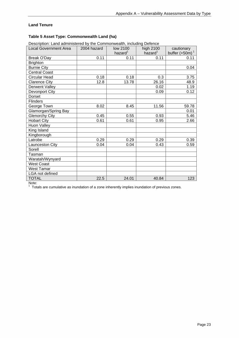
Table 5 Asset Type: Commonwealth Land (ha)
Description: Land administered by the Commonwealth, including DefenceLocal Government Area 2004 hazard low 2100
hazard1high 2100hazard1
cautionarybuffer (+50m) 1
Break O'Day 0.11 0.11 0.11 0.11BrightonBurnie City 0.04Central CoastCircular Head 0.18 0.18 0.3 3.75Clarence City 12.8 13.78 26.16 48.9Derwent Valley 0.02 1.19Devonport City 0.09 0.12DorsetFlindersGeorge Town 8.02 8.45 11.56 59.78Glamorgan/Spring Bay 0.01Glenorchy City 0.45 0.55 0.93 5.46Hobart City 0.61 0.61 0.95 2.66Huon ValleyKing IslandKingboroughLatrobe 0.29 0.29 0.29 0.39Launceston City 0.04 0.04 0.43 0.59SorellTasmanWaratah/WynyardWest CoastWest TamarLGA not definedTOTAL 22.5 24.01 40.84 123Note:1 Totals are cumulative as inundation of a zone inherently implies inundation of previous zones.

Appendix A – Vulnerability Assessment Data by Type
Page 24
Table 6 Asset Type: Historical Sites (ha)
Description: Land classed as Historic Site under the National Parks and Reserve Management Act2002Local Government Area 2004 hazard low 2100
hazard1high 2100hazard1
cautionarybuffer (+50m) 1
Break O'Day 0.49 0.57 0.86 6.97BrightonBurnie CityCentral CoastCircular HeadClarence City 0.71Derwent Valley 0.06 0.06Devonport CityDorsetFlinders 5.02 5.31 7.14 29.66George Town 2.35 2.35 2.68 13.47Glamorgan/Spring BayGlenorchy CityHobart CityHuon Valley 0.8 0.92 1.46 9.95King IslandKingborough 0.18 0.18 0.22 0.83LatrobeLaunceston CitySorellTasman 10.63 11.26 16.24 72.27Waratah/WynyardWest Coast 88.28 91.92 127.63 611.76West Tamar 6.31 6.52 6.76 11.68LGA not definedTOTAL 114.1 119.03 163.05 757.36Note:1 Totals are cumulative as inundation of a zone inherently implies inundation of previous zones.

Appendix A – Vulnerability Assessment Data by Type
Page 25
Table 7 Asset Type: Natural Reserves (ha)
Description: Land reserved for primarily natural reasons under the National Parks and ReserveManagement Act 2002, Crown Lands Act 1976, and Forestry Act 1920.
Local Government Area 2004 hazard low 2100hazard1
high 2100hazard1
cautionarybuffer (+50m) 1
Break O'Day 578.56 598.26 762.59 2326.13Brighton 27.23 29.2 44.54 140.81Burnie City 21.57 22.81 30.29 68.31Central Coast 147.64 149.73 173.66 300.61Circular Head 1121.87 1145.73 1377.02 4334.6Clarence City 163.96 172.8 254.26 720.12Derwent Valley 20.35 20.81 27.41 202.21Devonport City 50.94 51.65 59.03 115.44Dorset 664.78 681.04 846.56 2141.5Flinders 1914.41 2007.28 3154.56 6624.87George Town 115.22 118.17 143.9 375.48Glamorgan/Spring Bay 638.17 660.69 875.19 2577Glenorchy City 2.24 2.32 2.77 17.12Hobart City 0.10 0.1 0.4 1.33Huon Valley 1408.88 1465.06 2004.02 6616.71King Island 293.22 305.53 460.28 1435.41Kingborough 212.64 221.66 301.92 1328.76Latrobe 356.11 363.5 416.37 801.7Launceston City 45.52 46.24 51.39 211.9Sorell 86.99 90.14 121.34 318.49Tasman 131.85 139.4 212.63 1175.6Waratah/Wynyard 91.36 92.75 105.72 228.17West Coast 751.27 781.76 1102.31 5122.69West Tamar 292.88 296.36 325.93 756.57LGA not definedTOTAL 9137.75 9462.99 12854.09 37941.53Note:1 Totals are cumulative as inundation of a zone inherently implies inundation of previous zones.
Appendix A – Vulnerability Assessment Data by Type
Page 26
Table 8 Asset Type: Other Public Land (ha)
Description: Public land administered by a public agency or authority (State or Local), but not as aformal reserve for natural reasons, State Forest or private reserve.Local Government Area 2004 hazard low 2100
hazard1high 2100hazard1
cautionarybuffer (+50m) 1
Break O'Day 45.02 45.62 52.08 115.03Brighton 2.40 2.56 3.71 13.11Burnie City 25.79 25.98 28.16 43.95Central Coast 80.51 82.55 101.90 149.21Circular Head 407.50 416.14 502.30 722.41Clarence City 99.20 104.81 161.50 405.39Derwent Valley 4.22 4.41 6.27 18.50Devonport City 61.95 63.66 80.96 137.08Dorset 77.74 79.69 97.58 203.00Flinders 1057.91 1102.46 1638.28 4142.13George Town 58.80 61.04 79.53 191.03Glamorgan/Spring Bay 47.91 48.97 60.00 121.39Glenorchy City 23.02 24.02 33.73 84.98Hobart City 25.90 27.16 34.89 78.09Huon Valley 116.00 116.36 121.89 177.08King Island 28.31 29.36 37.25 105.91Kingborough 32.11 32.85 40.02 98.60Latrobe 59.29 61.32 79.21 115.16Launceston City 48.39 49.30 57.07 76.94Sorell 6.07 6.73 12.77 84.37Tasman 4.09 4.15 5.20 31.63Waratah/Wynyard 3.91 4.17 7.36 27.51West Coast 344.55 353.35 440.50 1137.10West Tamar 47.03 48.87 61.77 93.77LGA not definedTOTAL 2707.63 2795.55 3743.90 8373.35Note:1 Totals are cumulative as inundation of a zone inherently implies inundation of previous zones.

Appendix A – Vulnerability Assessment Data by Type
Page 27
Table 9 Asset Type: Private Reserves (ha)
Description: Formal private reserves under the National Parks and Reserve Management Act 2002Local Government Area 2004 hazard low 2100
hazard1high 2100hazard1
cautionarybuffer (+50m) 1
Break O'Day 48.73 49.15 53.65 62.35BrightonBurnie CityCentral CoastCircular Head 0.01 0.43 11.19Clarence City 37.43 37.99 42.07 53.17Derwent ValleyDevonport CityDorset 17.24 17.94 25.17 58.77Flinders 9.96 10.79 17.32 22.62George Town 1.48 1.59 2.68 40.48Glamorgan/Spring Bay 384.40 391.46 454.72 538.96Glenorchy CityHobart CityHuon Valley 0.24 0.24 0.28 2.70King IslandKingborough 17.76 18.01 20.09 55.91LatrobeLaunceston CitySorell 40.88 42.08 53.11 89.59Tasman 13.74 15.15 22.84 61.48Waratah/WynyardWest CoastWest TamarLGA not definedTOTAL 571.85 584.39 692.36 997.21Note:1 Totals are cumulative as inundation of a zone inherently implies inundation of previous zones.
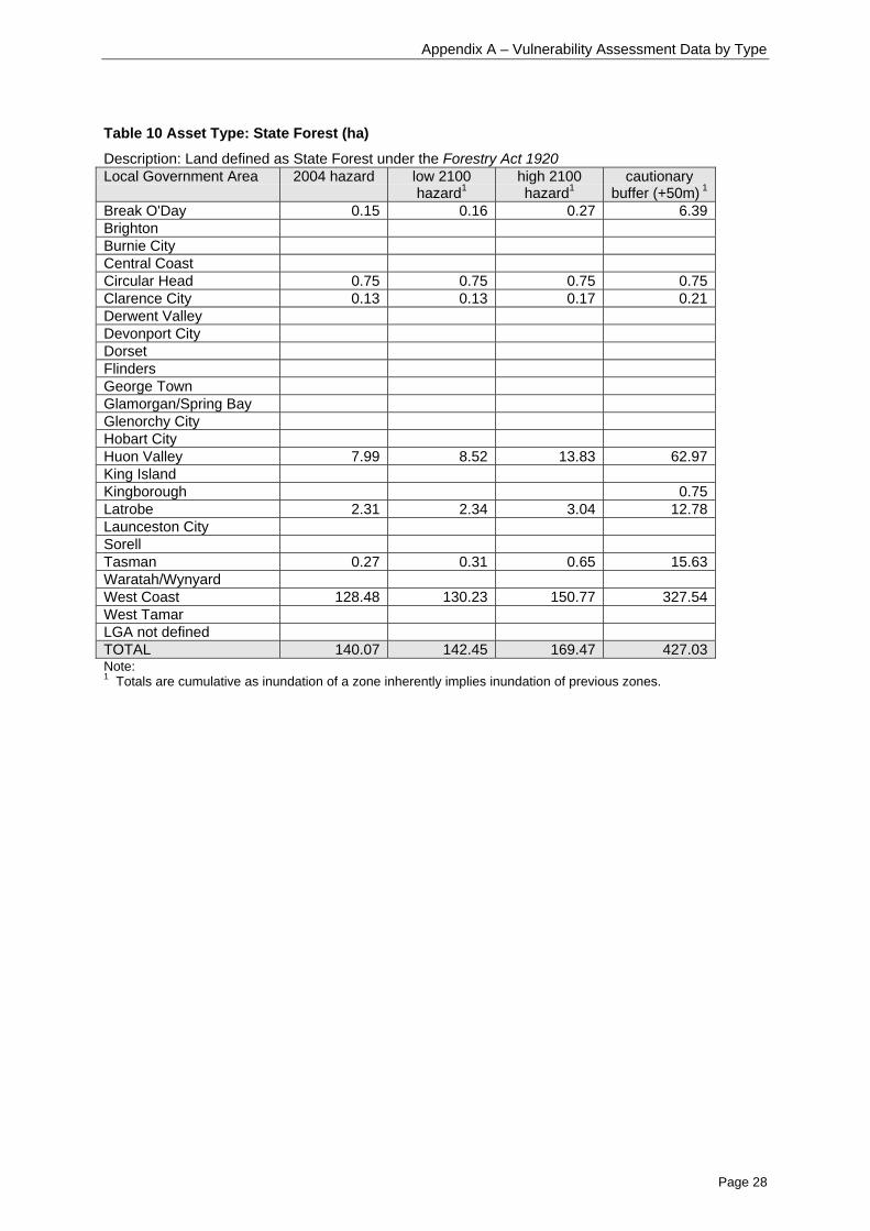
Appendix A – Vulnerability Assessment Data by Type
Page 28
Table 10 Asset Type: State Forest (ha)
Description: Land defined as State Forest under the Forestry Act 1920Local Government Area 2004 hazard low 2100
hazard1high 2100hazard1
cautionarybuffer (+50m) 1
Break O'Day 0.15 0.16 0.27 6.39BrightonBurnie CityCentral CoastCircular Head 0.75 0.75 0.75 0.75Clarence City 0.13 0.13 0.17 0.21Derwent ValleyDevonport CityDorsetFlindersGeorge TownGlamorgan/Spring BayGlenorchy CityHobart CityHuon Valley 7.99 8.52 13.83 62.97King IslandKingborough 0.75Latrobe 2.31 2.34 3.04 12.78Launceston CitySorellTasman 0.27 0.31 0.65 15.63Waratah/WynyardWest Coast 128.48 130.23 150.77 327.54West TamarLGA not definedTOTAL 140.07 142.45 169.47 427.03Note:1 Totals are cumulative as inundation of a zone inherently implies inundation of previous zones.
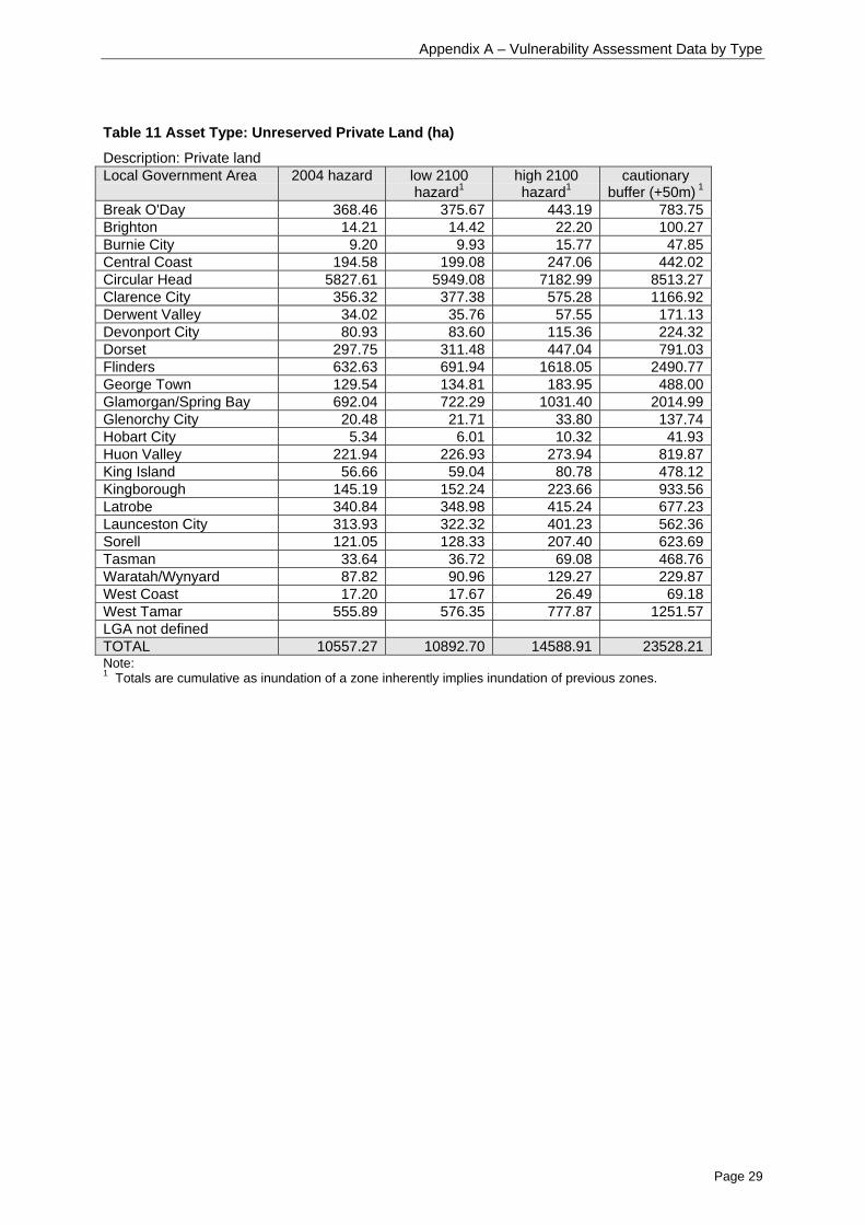
Appendix A – Vulnerability Assessment Data by Type
Page 29
Table 11 Asset Type: Unreserved Private Land (ha)
Description: Private landLocal Government Area 2004 hazard low 2100
hazard1high 2100hazard1
cautionarybuffer (+50m) 1
Break O'Day 368.46 375.67 443.19 783.75Brighton 14.21 14.42 22.20 100.27Burnie City 9.20 9.93 15.77 47.85Central Coast 194.58 199.08 247.06 442.02Circular Head 5827.61 5949.08 7182.99 8513.27Clarence City 356.32 377.38 575.28 1166.92Derwent Valley 34.02 35.76 57.55 171.13Devonport City 80.93 83.60 115.36 224.32Dorset 297.75 311.48 447.04 791.03Flinders 632.63 691.94 1618.05 2490.77George Town 129.54 134.81 183.95 488.00Glamorgan/Spring Bay 692.04 722.29 1031.40 2014.99Glenorchy City 20.48 21.71 33.80 137.74Hobart City 5.34 6.01 10.32 41.93Huon Valley 221.94 226.93 273.94 819.87King Island 56.66 59.04 80.78 478.12Kingborough 145.19 152.24 223.66 933.56Latrobe 340.84 348.98 415.24 677.23Launceston City 313.93 322.32 401.23 562.36Sorell 121.05 128.33 207.40 623.69Tasman 33.64 36.72 69.08 468.76Waratah/Wynyard 87.82 90.96 129.27 229.87West Coast 17.20 17.67 26.49 69.18West Tamar 555.89 576.35 777.87 1251.57LGA not definedTOTAL 10557.27 10892.70 14588.91 23528.21Note:1 Totals are cumulative as inundation of a zone inherently implies inundation of previous zones.

Appendix A – Vulnerability Assessment Data by Type
Page 30
Community Facilities etc
Table 12 Asset Type: Boating and Surf Lifesaving Clubs (number)
Description: Rowing, Surf life saving and Yacht and sailing clubsLocal Government Area 2004 hazard low 2100
hazard1high 2100hazard1
cautionarybuffer (+50m) 1
Break O'Day 0 0 0 0Brighton 0 0 0 0Burnie City 2 2 2 2Central Coast 3 3 3 4Circular Head 0 0 0 0Clarence City 0 0 1 5Derwent Valley 0 0 0 2Devonport City 2 2 3 5Dorset 0 0 0 1Flinders 0 0 0 0George Town 2 2 2 2Glamorgan/Spring Bay 0 0 0 0Glenorchy City 2 2 3 4Hobart City 2 2 2 10Huon Valley 2 2 3 3Kingborough 0 0 1 3King Island 0 0 0 0Latrobe 0 0 0 0Launceston City 2 2 3 3Sorell 0 0 0 2Tasman 0 0 0 0Waratah/Wynyard 2 2 2 3West Coast 1 1 1 1West Tamar 1 1 1 3LGA not definedTOTAL 21 21 27 53Note:1 Totals are cumulative as inundation of a zone inherently implies inundation of previous zones.

Appendix A – Vulnerability Assessment Data by Type
Page 31
Table 13 Asset Type: Burial Sites (number)
Description: A cemetery.Local Government Area 2004 hazard low 2100
hazard1high 2100hazard1
Cautionarybuffer (+50m) 1
Break O'Day 0 0 0 0Brighton 0 0 0 0Burnie City 0 0 0 0Central Coast 0 0 0 1Circular Head 0 0 1 2Clarence City 0 0 0 0Derwent Valley 0 0 0 0Devonport City 0 0 0 0Dorset 0 0 0 0Flinders 0 0 0 0George Town 0 0 0 0Glamorgan/Spring Bay 2 2 2 2Glenorchy City 0 0 0 0Hobart City 0 0 0 0Huon Valley 0 0 0 1Kingborough 0 0 0 0King Island 0 0 0 0Latrobe 0 0 0 0Launceston City 0 0 0 0Sorell 0 0 0 1Tasman 0 0 0 0Waratah/Wynyard 0 0 0 1West Coast 0 0 0 0West Tamar 0 0 0 0LGA not definedTOTAL 2 2 3 8Note:1 Totals are cumulative as inundation of a zone inherently implies inundation of previous zones.
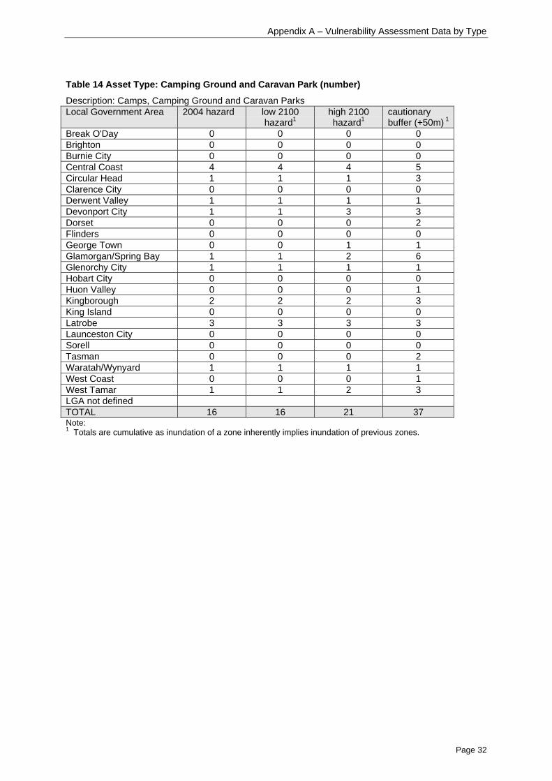
Appendix A – Vulnerability Assessment Data by Type
Page 32
Table 14 Asset Type: Camping Ground and Caravan Park (number)
Description: Camps, Camping Ground and Caravan ParksLocal Government Area 2004 hazard low 2100
hazard1high 2100hazard1
cautionarybuffer (+50m) 1
Break O'Day 0 0 0 0Brighton 0 0 0 0Burnie City 0 0 0 0Central Coast 4 4 4 5Circular Head 1 1 1 3Clarence City 0 0 0 0Derwent Valley 1 1 1 1Devonport City 1 1 3 3Dorset 0 0 0 2Flinders 0 0 0 0George Town 0 0 1 1Glamorgan/Spring Bay 1 1 2 6Glenorchy City 1 1 1 1Hobart City 0 0 0 0Huon Valley 0 0 0 1Kingborough 2 2 2 3King Island 0 0 0 0Latrobe 3 3 3 3Launceston City 0 0 0 0Sorell 0 0 0 0Tasman 0 0 0 2Waratah/Wynyard 1 1 1 1West Coast 0 0 0 1West Tamar 1 1 2 3LGA not definedTOTAL 16 16 21 37Note:1 Totals are cumulative as inundation of a zone inherently implies inundation of previous zones.

Appendix A – Vulnerability Assessment Data by Type
Page 33
Table 15 Asset Type: Car park (number)
Description: A public car park.Local Government Area 2004 hazard low 2100
hazard1high 2100hazard1
cautionarybuffer (+50m) 1
Break O'Day 0 0 0 0Brighton 0 0 0 0Burnie City 1 1 1 1Central Coast 0 0 0 2Circular Head 0 0 0 0Clarence City 0 0 0 0Derwent Valley 0 0 0 0Devonport City 0 0 1 1Dorset 0 0 0 0Flinders 0 0 0 0George Town 0 0 0 0Glamorgan/Spring Bay 0 0 0 0Glenorchy City 0 0 0 0Hobart City 2 2 2 3Huon Valley 0 0 0 0Kingborough 0 0 0 0King Island 0 0 0 0Latrobe 0 0 0 0Launceston City 3 3 3 3Sorell 0 0 0 0Tasman 0 0 0 0Waratah/Wynyard 0 0 0 0West Coast 0 0 0 0West Tamar 0 0 0 0LGA not definedTOTAL 6 6 7 10Note:1 Totals are cumulative as inundation of a zone inherently implies inundation of previous zones.

Appendix A – Vulnerability Assessment Data by Type
Page 34
Table 16 Asset Type: Churches (number)
Description: A place used for religious purposes by a particular sect. (LIST definition)Local Government Area 2004 hazard low 2100
hazard1high 2100hazard1
Cautionarybuffer (+50m) 1
Break O'Day 4 4 4 5Brighton 0 0 0 0Burnie City 0 0 0 0Central Coast 0 0 1 2Circular Head 0 0 0 0Clarence City 1 1 1 1Derwent Valley 0 0 0 0Devonport City 0 0 0 0Dorset 0 0 0 0Flinders 0 0 0 0George Town 2 2 3 4Glamorgan/Spring Bay 0 0 0 0Glenorchy City 0 0 0 0Hobart City 0 0 0 1Huon Valley 0 0 0 0Kingborough 0 0 1 1King Island 0 0 0 0Latrobe 2 2 2 2Launceston City 0 0 1 3Sorell 0 0 0 0Tasman 0 0 0 0Waratah/Wynyard 0 0 1 2West Coast 0 0 0 0West Tamar 0 0 0 1LGA not definedTOTAL 9 9 14 22Note:1 Totals are cumulative as inundation of a zone inherently implies inundation of previous zones.
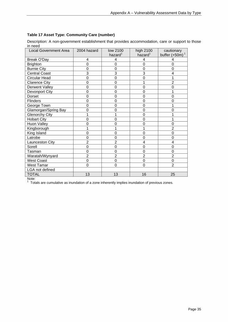
Appendix A – Vulnerability Assessment Data by Type
Page 35
Table 17 Asset Type: Community Care (number)
Description: A non-government establishment that provides accommodation, care or support to thosein needLocal Government Area 2004 hazard low 2100
hazard1high 2100hazard1
cautionarybuffer (+50m) 1
Break O'Day 4 4 4 4Brighton 0 0 0 0Burnie City 0 0 0 0Central Coast 3 3 3 4Circular Head 0 0 0 1Clarence City 0 0 1 2Derwent Valley 0 0 0 0Devonport City 0 0 0 1Dorset 0 0 0 0Flinders 0 0 0 0George Town 0 0 0 1Glamorgan/Spring Bay 0 0 0 0Glenorchy City 1 1 0 1Hobart City 0 0 0 1Huon Valley 0 0 0 0Kingborough 1 1 1 2King Island 0 0 0 0Latrobe 0 0 0 0Launceston City 2 2 4 4Sorell 0 0 0 0Tasman 0 0 0 0Waratah/Wynyard 2 2 2 2West Coast 0 0 0 0West Tamar 0 0 0 2LGA not definedTOTAL 13 13 16 25Note:1 Totals are cumulative as inundation of a zone inherently implies inundation of previous zones.

Appendix A – Vulnerability Assessment Data by Type
Page 36
Table 18 Asset Type: Hall/Community Centre (number)
Description: A hall or community centre belonging to a particular community, council, group ororganisation.Local Government Area 2004 hazard low 2100
hazard1high 2100hazard1
Cautionarybuffer (+50m) 1
Break O'Day 3 3 3 3Brighton 0 0 0 0Burnie City 0 0 0 0Central Coast 1 1 1 3Circular Head 0 0 0 0Clarence City 2 2 2 3Derwent Valley 0 0 0 1Devonport City 0 0 0 0Dorset 0 0 0 0Flinders 0 0 0 0George Town 1 1 1 3Glamorgan/Spring Bay 0 0 0 1Glenorchy City 0 0 0 1Hobart City 0 0 0 1Huon Valley 0 0 1 1Kingborough 0 0 0 5King Island 0 0 0 0Latrobe 1 1 1 1Launceston City 0 0 0 0Sorell 0 0 0 1Tasman 0 0 0 2Waratah/Wynyard 0 0 0 0West Coast 0 0 0 0West Tamar 1 1 1 2LGA not definedTOTAL 9 9 10 28Note:1 Totals are cumulative as inundation of a zone inherently implies inundation of previous zones.

Appendix A – Vulnerability Assessment Data by Type
Page 37
Table 19 Asset Type: Cultural Areas (number)
Description: A cultural featureLocal Government Area 2004 hazard Low 2100
hazard1high 2100hazard1
cautionarybuffer (+50m) 1
Break O'Day 0 0 0 0Brighton 0 0 0 0Burnie City 0 0 0 0Central Coast 0 0 0 0Circular Head 0 0 0 0Clarence City 0 0 0 0Derwent Valley 0 0 1 1Devonport City 0 0 0 0Dorset 0 0 0 0Flinders 0 0 0 0George Town 0 0 0 0Glamorgan/Spring Bay 0 0 1 2Glenorchy City 0 0 0 0Hobart City 0 0 2 2Huon Valley 0 0 0 1Kingborough 0 0 0 0King Island 0 0 0 0Latrobe 0 0 0 0Launceston City 0 0 0 0Sorell 0 0 0 1Tasman 0 0 0 0Waratah/Wynyard 0 0 2 3West Coast 0 0 1 2West Tamar 0 0 0 0LGA not definedTOTAL 0 0 7 12Note:1 Totals are cumulative as inundation of a zone inherently implies inundation of previous zones.

Appendix A – Vulnerability Assessment Data by Type
Page 38
Table 20 Asset Type: Historical (number)
Description: A historical featureLocal Government Area 2004 hazard Low 2100
hazard1high 2100hazard1
cautionarybuffer (+50m) 1
Break O'Day 0 0 0 0Brighton 0 0 0 0Burnie City 0 0 0 0Central Coast 0 0 0 0Circular Head 0 0 0 0Clarence City 0 0 0 0Derwent Valley 0 0 0 0Devonport City 0 0 0 0Dorset 0 0 0 0Flinders 0 0 0 0George Town 0 0 0 0Glamorgan/Spring Bay 1 1 1 1Glenorchy City 0 0 0 1Hobart City 0 0 0 1Huon Valley 0 0 0 0Kingborough 1 1 1 3King Island 0 0 0 0Latrobe 0 0 0 0Launceston City 0 0 0 1Sorell 0 0 0 1Tasman 0 0 0 1Waratah/Wynyard 0 0 0 2West Coast 0 0 0 0West Tamar 0 0 0 0LGA not definedTOTAL 2 2 2 11Note:1 Totals are cumulative as inundation of a zone inherently implies inundation of previous zones.

Appendix A – Vulnerability Assessment Data by Type
Page 39
Table 21 Asset Type: Libraries (number)
Description: A place containing an organised collection of literary material, films, recordings, music, orother documents. Excludes private video libraryLocal Government Area 2004 hazard low 2100
hazard1high 2100hazard1
Cautionarybuffer (+50m) 1
Break O'Day 1 1 1 1Brighton 0 0 0 0Burnie City 0 0 0 0Central Coast 0 0 1 1Circular Head 0 0 0 0Clarence City 0 0 0 0Derwent Valley 0 0 0 0Devonport City 0 0 0 0Dorset 0 0 0 0Flinders 0 0 0 0George Town 0 0 0 0Glamorgan/Spring Bay 0 0 0 0Glenorchy City 0 0 0 0Hobart City 0 0 0 0Huon Valley 0 0 0 0Kingborough 0 0 0 0King Island 0 0 0 0Latrobe 0 0 0 0Launceston City 0 0 0 0Sorell 0 0 0 0Tasman 0 0 0 0Waratah/Wynyard 0 0 0 0West Coast 0 0 0 0West Tamar 0 0 0 0LGA not definedTOTAL 1 1 2 2Note:1 Totals are cumulative as inundation of a zone inherently implies inundation of previous zones.

Appendix A – Vulnerability Assessment Data by Type
Page 40
Table 22 Asset Type: Medical Services (number)
Description: A public or private establishment, other than a private medical or para-medical practice,that provides treatment, care, accommodation or insurance for the ill or injuredLocal Government Area 2004 hazard low 2100
hazard1high 2100hazard1
Cautionarybuffer (+50m) 1
Break O'Day 2 2 2 2Brighton 0 0 0 0Burnie City 1 1 2 2Central Coast 0 0 0 0Circular Head 1 1 1 1Clarence City 0 0 1 4Derwent Valley 0 0 0 0Devonport City 0 0 0 0Dorset 0 0 0 0Flinders 0 0 0 0George Town 0 0 0 0Glamorgan/Spring Bay 1 1 1 1Glenorchy City 0 0 0 0Hobart City 0 0 1 1Huon Valley 0 0 0 1Kingborough 0 0 0 1King Island 0 0 0 0Latrobe 0 0 0 0Launceston City 0 0 0 0Sorell 0 0 0 0Tasman 0 0 0 0Waratah/Wynyard 0 0 0 0West Coast 0 0 0 0West Tamar 0 0 0 0LGA not definedTOTAL 5 5 8 13Note:1 Totals are cumulative as inundation of a zone inherently implies inundation of previous zones.

Appendix A – Vulnerability Assessment Data by Type
Page 41
Table 23 Asset Type: Museums and Galleries (number)
Description: Gallery - A place for exhibiting works of art and craft. Museum - A place for keeping,exhibiting and studying objects of scientific, artistic, and historical interest.Local Government Area 2004 hazard low 2100
hazard1high 2100hazard1
Cautionarybuffer (+50m) 1
Break O'Day 1 1 1 1Brighton 0 0 0 0Burnie City 0 0 0 0Central Coast 0 0 0 0Circular Head 0 0 0 0Clarence City 0 0 0 0Derwent Valley 0 0 0 0Devonport City 1 1 1 1Dorset 0 0 0 0Flinders 0 0 0 1George Town 1 1 1 1Glamorgan/Spring Bay 0 0 0 0Glenorchy City 0 0 0 1Hobart City 0 0 0 2Huon Valley 0 0 0 0Kingborough 0 0 0 2King Island 0 0 0 0Latrobe 0 0 0 0Launceston City 0 0 0 2Sorell 0 0 0 1Tasman 0 0 0 0Waratah/Wynyard 0 0 0 0West Coast 0 0 0 0West Tamar 0 0 0 0LGA not definedTOTAL 3 3 3 12Note:1 Totals are cumulative as inundation of a zone inherently implies inundation of previous zones.

Appendix A – Vulnerability Assessment Data by Type
Page 42
Table 24 Asset Type: Natural (number)
Description: A natural featureLocal Government Area 2004 hazard low 2100
hazard1high 2100hazard1
Cautionarybuffer (+50m) 1
Break O'Day 0 0 0 1Brighton 0 0 0 0Burnie City 0 0 0 0Central Coast 0 0 0 0Circular Head 0 0 0 1Clarence City 0 0 0 0Derwent Valley 0 0 0 0Devonport City 0 0 0 1Dorset 0 0 0 0Flinders 0 0 0 0George Town 0 0 0 0Glamorgan/Spring Bay 1 0 1 2Glenorchy City 0 0 0 0Hobart City 0 0 0 0Huon Valley 1 0 1 1Kingborough 0 0 0 0King Island 0 0 0 0Latrobe 0 0 0 0Launceston City 0 0 0 0Sorell 0 0 0 0Tasman 0 0 0 1Waratah/Wynyard 0 0 0 0West Coast 0 0 0 0West Tamar 0 0 0 0LGA not definedTOTAL 2 2 2 7Note:1 Totals are cumulative as inundation of a zone inherently implies inundation of previous zones.

Appendix A – Vulnerability Assessment Data by Type
Page 43
Table 25 Asset Type: Park or Reserve (number)
Description: A small public ground for informal, outdoor recreation belonging to and/or maintained by aCouncil or community organisationLocal Government Area 2004 hazard low 2100
hazard1high 2100hazard1
Cautionarybuffer (+50m) 1
Break O'Day 2 2 2 2Brighton 0 0 0 0Burnie City 1 1 1 1Central Coast 10 10 14 18Circular Head 4 4 4 6Clarence City 4 4 6 15Derwent Valley 1 1 2 3Devonport City 1 1 1 1Dorset 0 0 1 1Flinders 0 0 0 0George Town 1 1 2 2Glamorgan/Spring Bay 0 0 1 2Glenorchy City 2 2 5 10Hobart City 1 1 2 6Huon Valley 2 2 2 4Kingborough 1 1 1 5King Island 0 0 0 1Latrobe 0 0 0 2Launceston City 1 1 2 2Sorell 0 0 0 0Tasman 0 0 0 1Waratah/Wynyard 1 1 3 3West Coast 0 0 1 3West Tamar 3 3 4 4LGA not definedTOTAL 35 35 54 92Note:1 Totals are cumulative as inundation of a zone inherently implies inundation of previous zones.
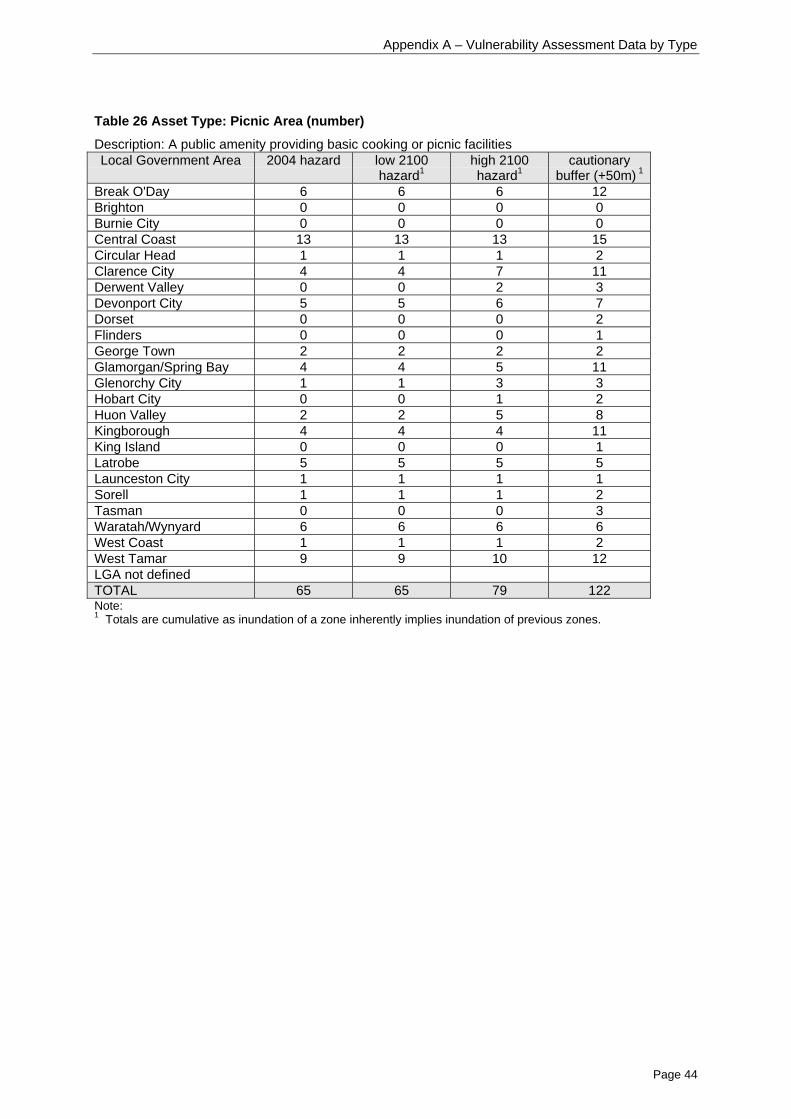
Appendix A – Vulnerability Assessment Data by Type
Page 44
Table 26 Asset Type: Picnic Area (number)
Description: A public amenity providing basic cooking or picnic facilitiesLocal Government Area 2004 hazard low 2100
hazard1high 2100hazard1
cautionarybuffer (+50m) 1
Break O'Day 6 6 6 12Brighton 0 0 0 0Burnie City 0 0 0 0Central Coast 13 13 13 15Circular Head 1 1 1 2Clarence City 4 4 7 11Derwent Valley 0 0 2 3Devonport City 5 5 6 7Dorset 0 0 0 2Flinders 0 0 0 1George Town 2 2 2 2Glamorgan/Spring Bay 4 4 5 11Glenorchy City 1 1 3 3Hobart City 0 0 1 2Huon Valley 2 2 5 8Kingborough 4 4 4 11King Island 0 0 0 1Latrobe 5 5 5 5Launceston City 1 1 1 1Sorell 1 1 1 2Tasman 0 0 0 3Waratah/Wynyard 6 6 6 6West Coast 1 1 1 2West Tamar 9 9 10 12LGA not definedTOTAL 65 65 79 122Note:1 Totals are cumulative as inundation of a zone inherently implies inundation of previous zones.
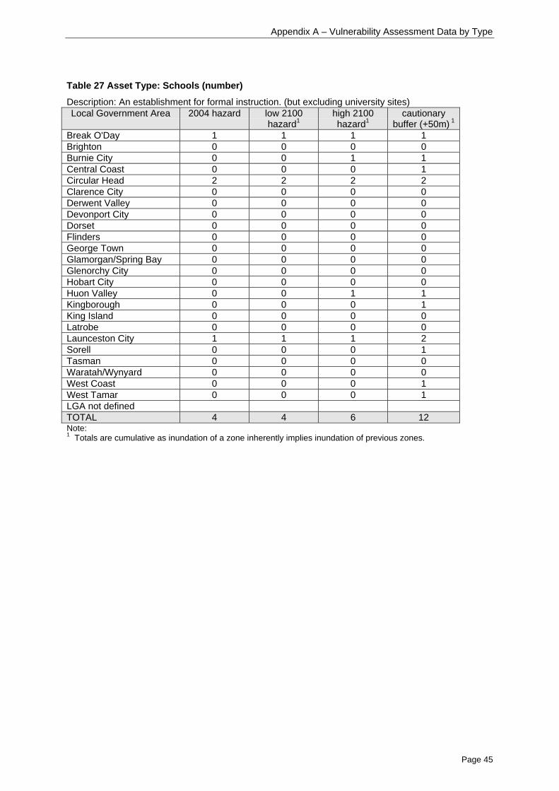
Appendix A – Vulnerability Assessment Data by Type
Page 45
Table 27 Asset Type: Schools (number)
Description: An establishment for formal instruction. (but excluding university sites)Local Government Area 2004 hazard low 2100
hazard1high 2100hazard1
cautionarybuffer (+50m) 1
Break O'Day 1 1 1 1Brighton 0 0 0 0Burnie City 0 0 1 1Central Coast 0 0 0 1Circular Head 2 2 2 2Clarence City 0 0 0 0Derwent Valley 0 0 0 0Devonport City 0 0 0 0Dorset 0 0 0 0Flinders 0 0 0 0George Town 0 0 0 0Glamorgan/Spring Bay 0 0 0 0Glenorchy City 0 0 0 0Hobart City 0 0 0 0Huon Valley 0 0 1 1Kingborough 0 0 0 1King Island 0 0 0 0Latrobe 0 0 0 0Launceston City 1 1 1 2Sorell 0 0 0 1Tasman 0 0 0 0Waratah/Wynyard 0 0 0 0West Coast 0 0 0 1West Tamar 0 0 0 1LGA not definedTOTAL 4 4 6 12Note:1 Totals are cumulative as inundation of a zone inherently implies inundation of previous zones.

Appendix A – Vulnerability Assessment Data by Type
Page 46
Table 28 Asset Type: Scouts and Girl Guides (number)
Description: A meeting place of a scouting organisation or Guides TasmaniaLocal Government Area 2004 hazard low 2100
hazard1high 2100hazard1
cautionarybuffer (+50m) 1
Break O'Day 0 0 0 1Brighton 0 0 0 0Burnie City 0 0 0 0Central Coast 0 0 0 1Circular Head 2 2 2 2Clarence City 0 0 0 2Derwent Valley 0 0 0 0Devonport City 0 0 0 0Dorset 0 0 0 0Flinders 0 0 0 0George Town 0 0 0 0Glamorgan/Spring Bay 0 0 0 1Glenorchy City 0 0 0 1Hobart City 1 1 2 2Huon Valley 0 0 0 0Kingborough 0 0 0 1King Island 0 0 0 0Latrobe 1 1 1 1Launceston City 2 2 2 2Sorell 0 0 0 0Tasman 0 0 0 0Waratah/Wynyard 0 0 0 0West Coast 0 0 0 0West Tamar 3 3 3 3LGA not definedTOTAL 9 9 10 17Note:1 Totals are cumulative as inundation of a zone inherently implies inundation of previous zones.
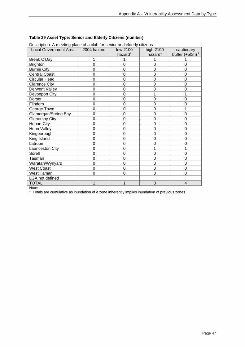
Appendix A – Vulnerability Assessment Data by Type
Page 47
Table 29 Asset Type: Senior and Elderly Citizens (number)
Description: A meeting place of a club for senior and elderly citizensLocal Government Area 2004 hazard low 2100
hazard1high 2100hazard1
cautionarybuffer (+50m) 1
Break O'Day 1 1 1 1Brighton 0 0 0 0Burnie City 0 0 0 0Central Coast 0 0 0 0Circular Head 0 0 0 0Clarence City 0 0 0 0Derwent Valley 0 0 0 0Devonport City 0 0 1 1Dorset 0 0 0 0Flinders 0 0 0 0George Town 0 0 0 1Glamorgan/Spring Bay 0 0 0 0Glenorchy City 0 0 0 0Hobart City 0 0 0 0Huon Valley 0 0 0 0Kingborough 0 0 0 0King Island 0 0 0 0Latrobe 0 0 0 0Launceston City 0 0 1 1Sorell 0 0 0 0Tasman 0 0 0 0Waratah/Wynyard 0 0 0 0West Coast 0 0 0 0West Tamar 0 0 0 0LGA not definedTOTAL 1 1 3 4Note:1 Totals are cumulative as inundation of a zone inherently implies inundation of previous zones.

Appendix A – Vulnerability Assessment Data by Type
Page 48
Table 30 Asset Type: Service Station (number)
Description: A retail fuel outletLocal Government Area 2004 hazard low 2100
hazard1high 2100hazard1
Cautionarybuffer (+50m) 1
Break O'Day 2 2 2 2Brighton 0 0 0 0Burnie City 0 0 0 6Central Coast 1 1 1 3Circular Head 1 1 1 1Clarence City 4 4 4 4Derwent Valley 0 0 0 0Devonport City 0 0 0 1Dorset 0 0 0 0Flinders 0 0 0 0George Town 0 0 0 1Glamorgan/Spring Bay 0 0 0 2Glenorchy City 0 0 0 1Hobart City 0 0 0 0Huon Valley 0 0 0 3Kingborough 0 0 2 5King Island 0 0 0 0Latrobe 0 0 0 0Launceston City 1 1 1 2Sorell 0 0 0 1Tasman 0 0 0 1Waratah/Wynyard 2 2 2 3West Coast 0 0 0 0West Tamar 2 2 2 2LGA not definedTOTAL 13 13 15 38Note:1 Totals are cumulative as inundation of a zone inherently implies inundation of previous zones.

Appendix A – Vulnerability Assessment Data by Type
Page 49
Table 31 Asset Type: Sports Building (number)
Description: Building for Indoor cricket, Squash, for more than one sport, Swimming pools or a facilityfor any other particular sportLocal Government Area 2004 hazard low 2100
hazard1high 2100hazard1
Cautionarybuffer (+50m) 1
Break O'Day 0 0 0 0Brighton 0 0 0 0Burnie City 0 0 0 1Central Coast 1 1 1 3Circular Head 1 1 1 3Clarence City 0 0 0 1Derwent Valley 1 1 1 2Devonport City 2 2 2 4Dorset 0 0 0 0Flinders 0 0 0 0George Town 0 0 0 1Glamorgan/Spring Bay 1 1 1 3Glenorchy City 0 0 0 2Hobart City 3 3 3 13Huon Valley 1 1 1 4Kingborough 2 2 3 4King Island 0 0 0 0Latrobe 0 0 0 0Launceston City 1 1 2 3Sorell 0 0 0 0Tasman 1 1 1 1Waratah/Wynyard 0 0 0 0West Coast 0 0 0 3West Tamar 0 0 0 0LGA not definedTOTAL 14 14 16 48Note:1 Totals are cumulative as inundation of a zone inherently implies inundation of previous zones.

Appendix A – Vulnerability Assessment Data by Type
Page 50
Table 32 Asset Type: Sports Clubs (number)
Description: A meeting place of any type of sporting club, including Bowls, Cricket, Croquet, Football,Golf, Gun and rifle, Rugby, Soccer, Tennis or Other sporting clubLocal Government Area 2004 hazard low 2100
hazard1high 2100hazard1
Cautionarybuffer (+50m) 1
Break O'Day 2 2 2 2Brighton 0 0 0 0Burnie City 0 0 0 2Central Coast 4 4 5 8Circular Head 4 4 5 5Clarence City 0 0 1 2Derwent Valley 0 0 0 2Devonport City 2 2 3 4Dorset 0 0 0 0Flinders 0 0 0 1George Town 1 1 1 3Glamorgan/Spring Bay 2 2 2 6Glenorchy City 0 0 0 3Hobart City 0 0 0 0Huon Valley 1 1 1 3Kingborough 1 1 2 5King Island 0 0 0 0Latrobe 2 2 2 2Launceston City 3 3 4 4Sorell 0 0 0 0Tasman 0 0 1 2Waratah/Wynyard 3 3 4 6West Coast 0 0 0 0West Tamar 2 2 2 3LGA not definedTOTAL 27 27 35 63Note:1 Totals are cumulative as inundation of a zone inherently implies inundation of previous zones.

Appendix A – Vulnerability Assessment Data by Type
Page 51
Table 33 Asset Type: Sports Ground (number)
Description: A ground used for a variety of sports, usually having grandstands for spectators andfacilities for playersLocal Government Area 2004 hazard low 2100
hazard1high 2100hazard1
cautionarybuffer (+50m) 1
Break O'Day 0 0 0 0Brighton 0 0 0 0Burnie City 0 0 0 0Central Coast 1 1 1 1Circular Head 0 0 0 0Clarence City 0 0 0 1Derwent Valley 0 0 0 0Devonport City 0 0 1 1Dorset 0 0 0 0Flinders 0 0 0 0George Town 0 0 0 0Glamorgan/Spring Bay 0 0 0 0Glenorchy City 0 0 0 1Hobart City 0 0 0 1Huon Valley 0 0 0 1Kingborough 0 0 1 2King Island 0 0 0 0Latrobe 0 0 0 0Launceston City 1 1 1 1Sorell 0 0 0 0Tasman 0 0 0 0Waratah/Wynyard 0 0 1 1West Coast 0 0 0 0West Tamar 1 1 1 1LGA not definedTOTAL 3 3 6 11Note:1 Totals are cumulative as inundation of a zone inherently implies inundation of previous zones.

Appendix A – Vulnerability Assessment Data by Type
Page 52
Table 34 Asset Type: State Police and Emergency Services
Description: An establishment for an operational unit or service of a Tasmanian government police oremergency service (but not a headquarters or administration unit)Local Government Area 2004 hazard low 2100
hazard1high 2100hazard1
cautionarybuffer (+50m) 1
Break O'Day 4 4 4 4Brighton 0 0 0 0Burnie City 0 0 0 0Central Coast 1 1 1 2Circular Head 1 1 1 3Clarence City 0 0 1 3Derwent Valley 0 0 0 0Devonport City 0 0 0 2Dorset 0 0 0 0Flinders 0 0 0 3George Town 0 0 0 1Glamorgan/Spring Bay 2 2 2 3Glenorchy City 0 0 0 0Hobart City 0 0 0 0Huon Valley 0 0 0 1Kingborough 0 0 0 3King Island 0 0 0 1Latrobe 1 1 1 2Launceston City 0 0 0 0Sorell 0 0 0 0Tasman 0 0 0 2Waratah/Wynyard 0 0 0 0West Coast 0 0 0 1West Tamar 1 1 1 1LGA not definedTOTAL 10 10 11 32Note:1 Totals are cumulative as inundation of a zone inherently implies inundation of previous zones.

Appendix A – Vulnerability Assessment Data by Type
Page 53
Table 35 Asset Type: Sewage Treatment and Waster Water plants (number)
Description: Sites in the LIST Community Services layer that include ‘sewage’ or ‘wastewater’ in theirdescription, and including lagoons, plants and works.Local Government Area 2004 hazard low 2100
hazard1high 2100hazard1
cautionarybuffer (+50m)1
Break O'Day 1 1 1 1Brighton 0 0 0 0Burnie City 1 1 2 2Central Coast 2 2 2 3Circular Head 1 1 1 2Clarence City 0 0 0 1Derwent Valley 0 0 0 0Devonport City 1 1 1 1Dorset 0 0 0 0Flinders 0 0 0 0George Town 0 0 0 0Glamorgan/Spring Bay 0 0 1 1Glenorchy City 0 0 0 1Hobart City 0 0 0 1Huon Valley 0 0 0 1Kingborough 0 0 0 1King Island 1 1 1 1Latrobe 0 0 0 1Launceston City 1 1 1 1Sorell 0 0 0 2Tasman 0 0 0 0Waratah/Wynyard 1 1 1 1West Coast 0 0 0 0West Tamar 0 0 1 1LGA not definedTOTAL 9 9 12 22Note:1 Totals are cumulative as inundation of a zone inherently implies inundation of previous zones.

Appendix A – Vulnerability Assessment Data by Type
Page 54
Roads
Table 36 Asset Type: State/ National Highway (m)
Description: Roads which are of importance in a national sense, and/or are a major intrastate throughroute, and/or are principal connector roads between Capitals and/or major regions and/or key townsLocal Government Area 2004 hazard low 2100
hazard1high 2100hazard1
cautionarybuffer (+50m) 1
Break O'Day 2064 2163 2691 8398Brighton 262 262 501 2049Burnie City 3025 3301 5867 17891Central Coast 2178 2224 3057 7528Circular Head 3849 4032 5214 10229Clarence City 735 798 1043 2879Derwent Valley 1041 1095 1811 8064Devonport City 2684 2425 3798 6209Dorset 0 0 0 0Flinders 0 0 0 0George Town 41 41 29 657Glamorgan/Spring Bay 1095 1295 3158 10315Glenorchy City 1387 1417 1608 2151Hobart City 305 310 432 3146Huon Valley 2218 2362 3869 21910Kingborough 615 677 1187 7824King Island 0 0 0 0Latrobe 0 0 0 0Launceston City 5473 5586 7075 11457Sorell 1047 1047 1379 3599Tasman 199 228 1011 8732Waratah/Wynyard 2476 2587 3318 5411West Coast 0 0 0 127West Tamar 0 0 3 1094LGA not definedTOTALNote:1 Totals are cumulative as inundation of a zone inherently implies inundation of previous zones.

Appendix A – Vulnerability Assessment Data by Type
Page 55
Table 37 Asset Type: Arterial Roads (Minor and Major) (m)
Description: A road that predominantly carries traffic from one region to another, forming a principalavenue of communication for traffic movementsLocal Government Area 2004 hazard low 2100
hazard1high 2100hazard1
cautionarybuffer (+50m) 1
Break O'Day 3921 3957 5143 8803Brighton 0 0 0 2710Burnie City 458 474 804 2184Central Coast 2124 2204 2803 7472Circular Head 3873 3942 4858 5680Clarence City 4937 4989 5955 8167Derwent Valley 396 429 636 2318Devonport City 1104 1104 1845 4874Dorset 1044 1076 1382 1543Flinders 3183 3399 4610 5654George Town 2289 2401 2998 3797Glamorgan/Spring Bay 0 0 5 1630Glenorchy City 375 380 797 4904Hobart City 175 184 328 2328Huon Valley 1006 1040 1516 4738Kingborough 2956 3007 3885 8706King Island 101 120 479 1328Latrobe 1173 1180 1288 2194Launceston City 3166 3203 4297 6841Sorell 643 663 809 3027Tasman 9 9 43 1741Waratah/Wynyard 5352 5356 5512 5640West Coast 68 85 192 719West Tamar 3301 3498 5347 13863LGA not definedTOTALNote:1 Totals are cumulative as inundation of a zone inherently implies inundation of previous zones.

Appendix A – Vulnerability Assessment Data by Type
Page 56
Table 38 Asset Type: Feeder Road (m)
Description: Commonly used roads that service urban networks, and/or rural communities, and/orresource areas. Normally connects access roads to higher classification roadsLocal Government Area 2004 hazard low 2100
hazard1high 2100hazard1
cautionarybuffer (+50m) 1
Break O'Day 1303 1436 2215 5747Brighton 46 46 46 612Burnie City 18 24 86 565Central Coast 4826 4957 5919 12299Circular Head 1429 1459 1684 1965Clarence City 3146 3259 4908 7726Derwent Valley 0 0 0 0Devonport City 1549 1581 2084 3348Dorset 0 0 376 1085Flinders 0 0 0 0George Town 117 124 163 668Glamorgan/Spring Bay 201 208 435 1426Glenorchy City 85 96 172 479Hobart City 64 78 317 2022Huon Valley 949 1157 2201 20109Kingborough 2648 2648 3829 9920King Island 0 0 0 0Latrobe 879 959 1318 4206Launceston City 0 0 156 674Sorell 3 3 80 2162Tasman 1511 1578 2988 7863Waratah/Wynyard 136 137 276 805West Coast 105 105 186 3028West Tamar 1869 1942 2507 4699LGA not definedTOTALNote:1 Totals are cumulative as inundation of a zone inherently implies inundation of previous zones.

Appendix A – Vulnerability Assessment Data by Type
Page 57
Table 39 Asset Type: Access Roads (m)
Description: Public or private road providing access to local properties, resources, facilities, or minortourism destinationsLocal Government Area 2004 hazard low 2100
hazard1high 2100hazard1
cautionarybuffer (+50m) 1
Break O'Day 16818 16818 19327 39141Brighton 618 618 1071 4242Burnie City 5846 6257 7741 15743Central Coast 21669 22160 26855 45505Circular Head 28266 29343 36761 49444Clarence City 17879 19178 31225 66900Derwent Valley 695 698 1406 7077Devonport City 9864 9864 11296 23512Dorset 1967 2069 3378 6906Flinders 6764 7071 12605 19743George Town 14237 14490 17801 33861Glamorgan/Spring Bay 14068 14892 21837 46452Glenorchy City 3058 3312 5253 18452Hobart City 2238 2328 3492 10619Huon Valley 5258 5698 10126 48066King Island 4330 4415 5863 14603Kingborough 10560 10614 13942 48126Latrobe 19276 19276 20999 26405Launceston City 19559 20073 26776 33498Sorell 2618 2770 4978 19327Tasman 3212 3346 7098 32178Waratah/Wynyard 11202 11513 15472 26128West Coast 881 1142 2433 8005West Tamar 26367 26624 31695 61749LGA not definedTOTALNote:1 Totals are cumulative as inundation of a zone inherently implies inundation of previous zones.

Appendix A – Vulnerability Assessment Data by Type
Page 58
Table 40 Asset Type: Vehicular Track (m)
Description: Rougher roads, usually unpaved, for vehicular trafficLocal Government Area 2004 hazard low 2100
hazard1high 2100hazard1
cautionarybuffer (+50m) 1
Break O'Day 10051 10145 11449 21368Brighton 170 208 357 2701Burnie City 353 432 538 1185Central Coast 2303 2331 3344 5833Circular Head 47760 49753 64104 102592Clarence City 3892 4291 6593 15493Derwent Valley 26 26 61 560Devonport City 222 222 222 349Dorset 7342 7879 12604 17673Flinders 15944 16861 33231 74217George Town 2704 2779 3616 11717Glamorgan/Spring Bay 20506 21502 31378 49595Glenorchy City 375 387 492 1827Hobart City 191 241 363 557Huon Valley 2242 2490 3629 14129King Island 7313 7682 10932 35515Kingborough 3084 3207 6392 22425Latrobe 2500 2514 3410 8070Launceston City 1465 1484 1714 3147Sorell 3833 3930 5095 12210Tasman 922 952 1781 8980Waratah/Wynyard 244 254 269 914West Coast 959 1011 3282 16904West Tamar 4445 3992 5727 8753LGA not definedTOTALNote:1 Totals are cumulative as inundation of a zone inherently implies inundation of previous zones.

Appendix A – Vulnerability Assessment Data by Type
Page 59
Parks and Wildlife Assets
Table 41 Asset Type: PWS Major Buildings (number)
Description: Houses, accommodation buildings and visitor centresLocal Government Area 2004 hazard low 2100
hazard1high 2100hazard1
cautionarybuffer (+50m) 1
Break O'Day 0 0 0 0Brighton 0 0 0 0Burnie City 0 0 0 0Central Coast 0 0 0 0Circular Head 0 0 0 1Clarence City 0 0 1 1Derwent Valley 0 0 0 0Devonport City 0 0 0 0Dorset 0 0 0 0Flinders 0 0 0 0George Town 6 6 7 7Glamorgan/Spring Bay 1 1 1 1Glenorchy City 0 0 0 0Hobart City 0 0 0 0Huon Valley 2 2 2 2Kingborough 0 0 0 1King Island 0 0 0 0Latrobe 0 0 0 0Launceston City 0 0 0 0Sorell 0 0 0 0Tasman 0 0 0 0Waratah/Wynyard 0 0 0 0West Coast 2 2 2 7West Tamar 0 0 0 1LGA not definedTOTAL 11 11 13 21Note:1 Totals are cumulative as inundation of a zone inherently implies inundation of previous zones.

Appendix A – Vulnerability Assessment Data by Type
Page 60
Table 42 Asset Type: PWS Minor Buildings (number)
Description: Shelters, information booths, stores, workshops, walker accommodation hutsLocal Government Area 2004 hazard low 2100
hazard1high 2100hazard1
cautionarybuffer (+50m) 1
Break O'Day 0 0 0 1Brighton 0 0 0 0Burnie City 0 0 0 0Central Coast 0 0 0 0Circular Head 0 0 0 2Clarence City 1 1 2 4Derwent Valley 0 0 0 0Devonport City 0 0 0 0Dorset 0 0 0 0Flinders 0 0 0 0George Town 14 14 15 15Glamorgan/Spring Bay 4 4 5 8Glenorchy City 0 0 0 0Hobart City 0 0 0 0Huon Valley 3 3 5 6Kingborough 1 1 1 2King Island 0 0 0 0Latrobe 1 1 1 2Launceston City 0 0 0 0Sorell 0 0 0 0Tasman 0 0 0 2Waratah/Wynyard 0 0 0 0West Coast 1 1 1 1West Tamar 1 1 1 5LGA not defined 3 3 3 7TOTAL 29 29 34 55Note:1 Totals are cumulative as inundation of a zone inherently implies inundation of previous zones.

Appendix A – Vulnerability Assessment Data by Type
Page 61
Table 43 Asset Type: PWS Camping Area (number)
Description: Camp sites (informal and defined)Local Government Area 2004 hazard low 2100
hazard1high 2100hazard1
cautionarybuffer (+50m) 1
Break O'Day 1 1 1 1Brighton 0 0 0 0Burnie City 0 0 0 0Central Coast 0 0 0 0Circular Head 1 1 1 1Clarence City 0 0 0 0Derwent Valley 0 0 0 0Devonport City 0 0 0 0Dorset 2 2 5 12Flinders 0 0 0 0George Town 0 0 0 0Glamorgan/Spring Bay 2 2 3 10Glenorchy City 0 0 0 0Hobart City 0 0 0 0Huon Valley 6 6 8 14Kingborough 1 1 1 1King Island 0 0 0 0Latrobe 1 1 3 3Launceston City 0 0 0 0Sorell 0 0 0 0Tasman 0 0 0 2Waratah/Wynyard 0 0 0 0West Coast 0 0 0 0West Tamar 0 0 0 0LGA not defined 0 0 0 10TOTAL 13 13 22 54Note:1 Totals are cumulative as inundation of a zone inherently implies inundation of previous zones.

Appendix A – Vulnerability Assessment Data by Type
Page 62
Table 44 Asset Type: PWS Car Park (number)
Description: Car park (formed and informal)Local Government Area 2004 hazard low 2100
hazard1high 2100hazard1
cautionarybuffer (+50m) 1
Break O'Day 0 0 0 2Brighton 0 0 0 0Burnie City 0 0 0 0Central Coast 1 1 1 1Circular Head 1 1 3 8Clarence City 2 2 4 6Derwent Valley 0 0 0 0Devonport City 0 0 0 1Dorset 1 1 2 2Flinders 0 0 0 1George Town 3 3 3 3Glamorgan/Spring Bay 1 2 3 13Glenorchy City 0 0 0 0Hobart City 0 0 0 0Huon Valley 0 0 0 0Kingborough 0 1 1 5King Island 0 0 0 0Latrobe 4 4 5 6Launceston City 0 0 0 0Sorell 0 0 0 0Tasman 0 0 0 3Waratah/Wynyard 1 2 3 4West Coast 1 1 1 1West Tamar 0 0 0 2LGA not defined 6 7 7 14TOTAL 21 25 33 72Note:1 Totals are cumulative as inundation of a zone inherently implies inundation of previous zones.

Appendix A – Vulnerability Assessment Data by Type
Page 63
Table 45 Asset Type: PWS Coastal Infrastructure (number)
Description: Boat ramps, slips and minor jettiesLocal Government Area 2004 hazard low 2100
hazard1high 2100hazard1
cautionarybuffer (+50m) 1
Break O'Day 0 0 0 0Brighton 0 0 0 0Burnie City 0 0 0 0Central Coast 0 0 0 0Circular Head 1 1 2 2Clarence City 0 0 0 0Derwent Valley 0 0 0 0Devonport City 0 0 0 0Dorset 1 1 1 1Flinders 0 0 0 0George Town 0 0 0 0Glamorgan/Spring Bay 0 0 0 0Glenorchy City 0 0 0 0Hobart City 0 0 0 0Huon Valley 2 2 3 4Kingborough 0 0 0 0King Island 0 0 0 0Latrobe 0 0 0 0Launceston City 0 0 0 0Sorell 0 0 0 0Tasman 1 1 1 1Waratah/Wynyard 0 0 0 0West Coast 2 2 2 3West Tamar 0 0 0 0LGA not defined 5 5 5 6TOTAL 12 12 14 17Note:1 Totals are cumulative as inundation of a zone inherently implies inundation of previous zones.
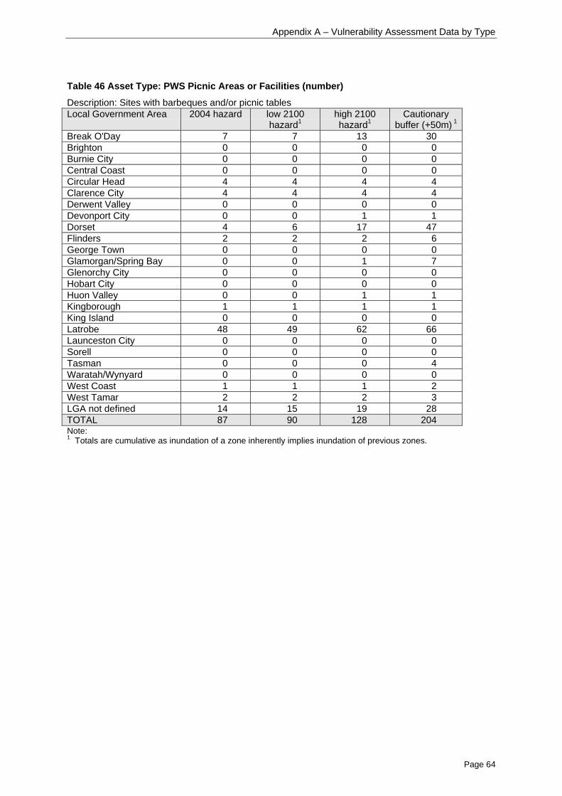
Appendix A – Vulnerability Assessment Data by Type
Page 64
Table 46 Asset Type: PWS Picnic Areas or Facilities (number)
Description: Sites with barbeques and/or picnic tablesLocal Government Area 2004 hazard low 2100
hazard1high 2100hazard1
Cautionarybuffer (+50m) 1
Break O'Day 7 7 13 30Brighton 0 0 0 0Burnie City 0 0 0 0Central Coast 0 0 0 0Circular Head 4 4 4 4Clarence City 4 4 4 4Derwent Valley 0 0 0 0Devonport City 0 0 1 1Dorset 4 6 17 47Flinders 2 2 2 6George Town 0 0 0 0Glamorgan/Spring Bay 0 0 1 7Glenorchy City 0 0 0 0Hobart City 0 0 0 0Huon Valley 0 0 1 1Kingborough 1 1 1 1King Island 0 0 0 0Latrobe 48 49 62 66Launceston City 0 0 0 0Sorell 0 0 0 0Tasman 0 0 0 4Waratah/Wynyard 0 0 0 0West Coast 1 1 1 2West Tamar 2 2 2 3LGA not defined 14 15 19 28TOTAL 87 90 128 204Note:1 Totals are cumulative as inundation of a zone inherently implies inundation of previous zones.

Appendix A – Vulnerability Assessment Data by Type
Page 65
Table 47 Asset Type: PWS Toilet (number)
Description: Toilets (including septic, pit, contained)Local Government Area 2004 hazard low 2100
hazard1high 2100hazard1
cautionarybuffer (+50m) 1
Break O'Day 2 2 2 20Brighton 0 0 0 0Burnie City 0 0 0 0Central Coast 0 0 0 0Circular Head 2 2 4 8Clarence City 3 3 6 6Derwent Valley 0 0 0 0Devonport City 0 0 0 0Dorset 4 4 10 17Flinders 0 0 0 2George Town 10 10 10 10Glamorgan/Spring Bay 2 2 6 19Glenorchy City 0 0 0 0Hobart City 0 0 0 0Huon Valley 5 5 7 14Kingborough 3 3 3 5King Island 1 1 1 1Latrobe 3 3 3 4Launceston City 0 0 0 0Sorell 0 0 0 0Tasman 0 0 0 4Waratah/Wynyard 0 0 0 0West Coast 3 3 4 6West Tamar 0 0 0 1LGA not defined 3 3 5 12TOTAL 41 41 61 129Note:1 Totals are cumulative as inundation of a zone inherently implies inundation of previous zones.
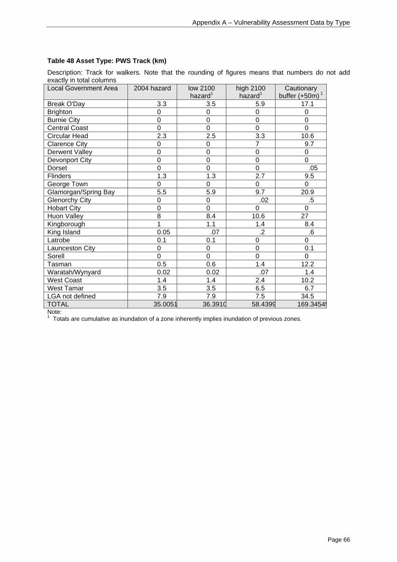
Appendix A – Vulnerability Assessment Data by Type
Page 66
Table 48 Asset Type: PWS Track (km)
Description: Track for walkers. Note that the rounding of figures means that numbers do not addexactly in total columnsLocal Government Area 2004 hazard low 2100
hazard1high 2100hazard1
Cautionarybuffer (+50m) 1
Break O'Day 3.3 3.5 5.9 17.1Brighton 0 0 0 0Burnie City 0 0 0 0Central Coast 0 0 0 0Circular Head 2.3 2.5 3.3 10.6Clarence City 0 0 7 9.7Derwent Valley 0 0 0 0Devonport City 0 0 0 0Dorset 0 0 0 .05Flinders 1.3 1.3 2.7 9.5George Town 0 0 0 0Glamorgan/Spring Bay 5.5 5.9 9.7 20.9Glenorchy City 0 0 .02 .5Hobart City 0 0 0 0Huon Valley 8 8.4 10.6 27Kingborough 1 1.1 1.4 8.4King Island 0.05 .07 .2 .6Latrobe 0.1 0.1 0 0Launceston City 0 0 0 0.1Sorell 0 0 0 0Tasman 0.5 0.6 1.4 12.2Waratah/Wynyard 0.02 0.02 .07 1.4West Coast 1.4 1.4 2.4 10.2West Tamar 3.5 3.5 6.5 6.7LGA not defined 7.9 7.9 7.5 34.5TOTAL 35.0051 36.3910 58.4399 169.34545Note:1 Totals are cumulative as inundation of a zone inherently implies inundation of previous zones.
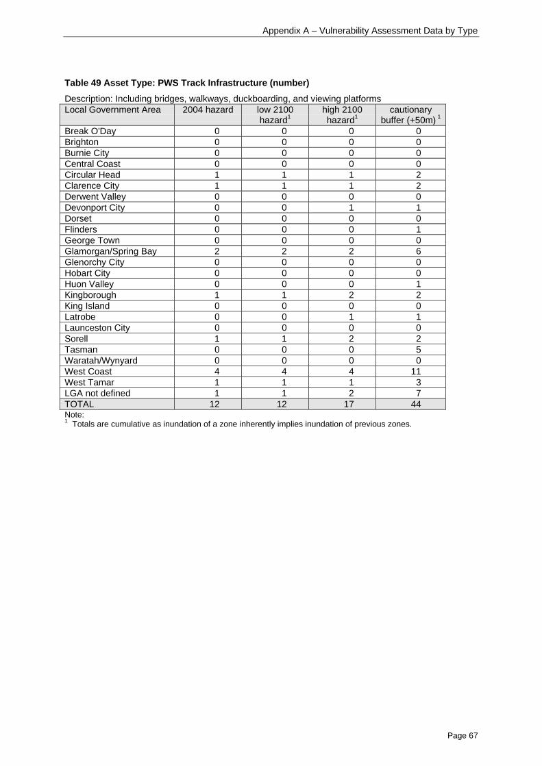
Appendix A – Vulnerability Assessment Data by Type
Page 67
Table 49 Asset Type: PWS Track Infrastructure (number)
Description: Including bridges, walkways, duckboarding, and viewing platformsLocal Government Area 2004 hazard low 2100
hazard1high 2100hazard1
cautionarybuffer (+50m) 1
Break O'Day 0 0 0 0Brighton 0 0 0 0Burnie City 0 0 0 0Central Coast 0 0 0 0Circular Head 1 1 1 2Clarence City 1 1 1 2Derwent Valley 0 0 0 0Devonport City 0 0 1 1Dorset 0 0 0 0Flinders 0 0 0 1George Town 0 0 0 0Glamorgan/Spring Bay 2 2 2 6Glenorchy City 0 0 0 0Hobart City 0 0 0 0Huon Valley 0 0 0 1Kingborough 1 1 2 2King Island 0 0 0 0Latrobe 0 0 1 1Launceston City 0 0 0 0Sorell 1 1 2 2Tasman 0 0 0 5Waratah/Wynyard 0 0 0 0West Coast 4 4 4 11West Tamar 1 1 1 3LGA not defined 1 1 2 7TOTAL 12 12 17 44Note:1 Totals are cumulative as inundation of a zone inherently implies inundation of previous zones.
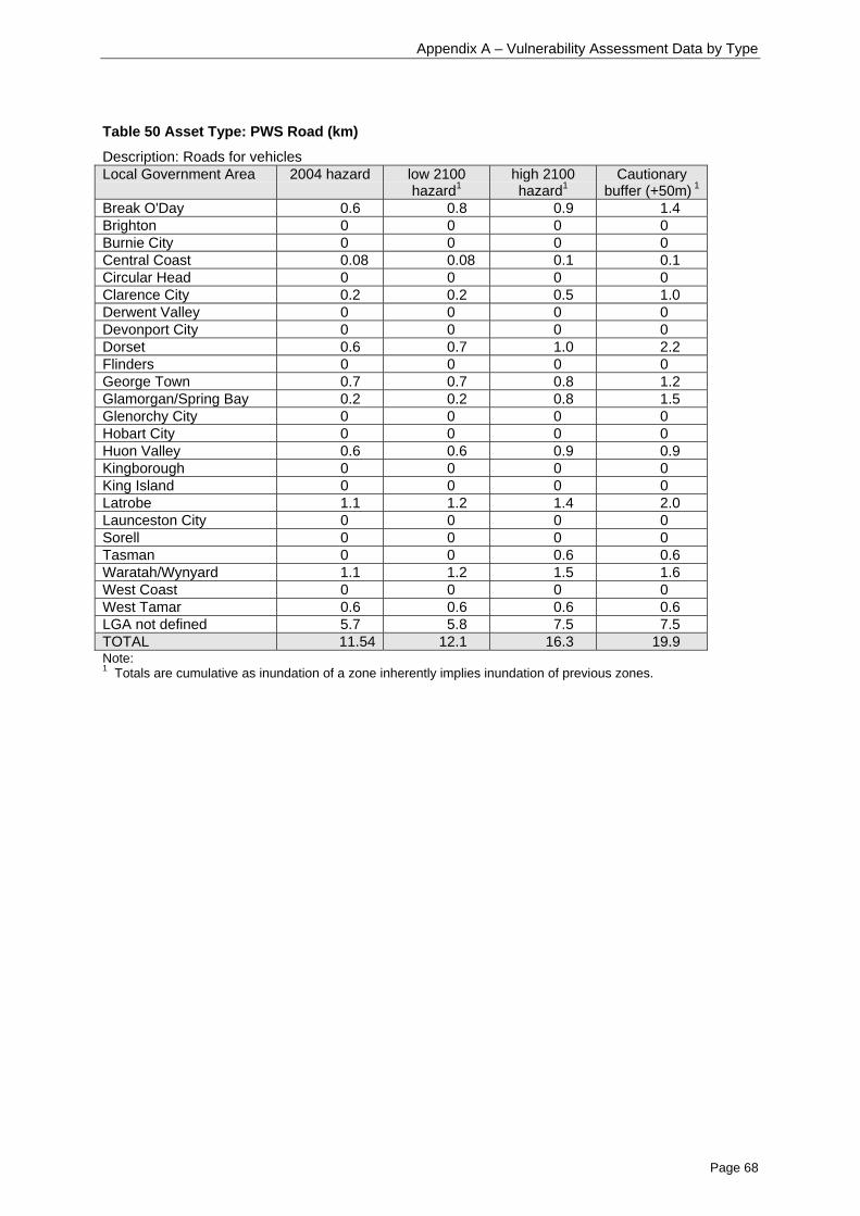
Appendix A – Vulnerability Assessment Data by Type
Page 68
Table 50 Asset Type: PWS Road (km)
Description: Roads for vehiclesLocal Government Area 2004 hazard low 2100
hazard1high 2100hazard1
Cautionarybuffer (+50m) 1
Break O'Day 0.6 0.8 0.9 1.4Brighton 0 0 0 0Burnie City 0 0 0 0Central Coast 0.08 0.08 0.1 0.1Circular Head 0 0 0 0Clarence City 0.2 0.2 0.5 1.0Derwent Valley 0 0 0 0Devonport City 0 0 0 0Dorset 0.6 0.7 1.0 2.2Flinders 0 0 0 0George Town 0.7 0.7 0.8 1.2Glamorgan/Spring Bay 0.2 0.2 0.8 1.5Glenorchy City 0 0 0 0Hobart City 0 0 0 0Huon Valley 0.6 0.6 0.9 0.9Kingborough 0 0 0 0King Island 0 0 0 0Latrobe 1.1 1.2 1.4 2.0Launceston City 0 0 0 0Sorell 0 0 0 0Tasman 0 0 0.6 0.6Waratah/Wynyard 1.1 1.2 1.5 1.6West Coast 0 0 0 0West Tamar 0.6 0.6 0.6 0.6LGA not defined 5.7 5.8 7.5 7.5TOTAL 11.54 12.1 16.3 19.9Note:1 Totals are cumulative as inundation of a zone inherently implies inundation of previous zones.

Appendix A – Vulnerability Assessment Data by Type
Page 69
Table 51 Asset Type: PWS Road Infrastructure (number)
Description: Includes barriers, bridges and cattle gridsLocal Government Area 2004 hazard low 2100
hazard1high 2100hazard1
cautionarybuffer (+50m) 1
Break O'Day 0 0 0 0Brighton 0 0 0 0Burnie City 0 0 0 0Central Coast 0 0 0 0Circular Head 0 0 2 2Clarence City 4 4 10 11Derwent Valley 0 0 0 0Devonport City 0 0 0 0Dorset 1 1 1 1Flinders 0 0 0 0George Town 2 2 2 2Glamorgan/Spring Bay 2 2 3 9Glenorchy City 0 0 0 0Hobart City 0 0 0 0Huon Valley 1 1 1 2Kingborough 0 0 0 0King Island 0 0 0 0Latrobe 3 3 3 3Launceston City 0 0 0 0Sorell 0 0 0 2Tasman 0 0 0 4Waratah/Wynyard 0 0 0 1West Coast 0 0 0 0West Tamar 0 0 0 0LGA not defined 0 0 0 6TOTAL 13 13 22 43Note:1 Totals are cumulative as inundation of a zone inherently implies inundation of previous zones.

Appendix A – Vulnerability Assessment Data by Type
Page 70
Environmental Permit Sites(Environment Division – Environmentally Relevant Land Use Register)
Table 52 Asset Type: Waste disposal sites (number)
Description: Sites for the disposal of waste, including both operating and closed sites. Does notinclude waste transfer stations.Local Government Area 2004 hazard low 2100
hazard1high 2100hazard1
cautionarybuffer (+50m) 1
Break O'Day 0 0 0 0Brighton 0 0 0 0Burnie City 0 0 0 0Central Coast 1 1 1 1Circular Head 3 3 3 3Clarence City 0 0 0 0Derwent Valley 0 0 0 0Devonport City 0 0 0 0Dorset 0 0 0 0Flinders 0 0 0 0George Town 0 0 0 0Glamorgan/Spring Bay 0 0 0 0Glenorchy City 0 0 0 0Hobart City 0 0 0 0Huon Valley 0 0 0 1Kingborough 0 0 0 0King Island 0 0 0 0Latrobe 0 0 0 0Launceston City 0 0 0 0Sorell 0 0 0 0Tasman 0 0 1 1Waratah/Wynyard 0 0 0 0West Coast 0 0 0 0West Tamar 0 0 0 0LGA not definedTOTAL 4 4 5 6Note:1 Totals are cumulative as inundation of a zone inherently implies inundation of previous zones.
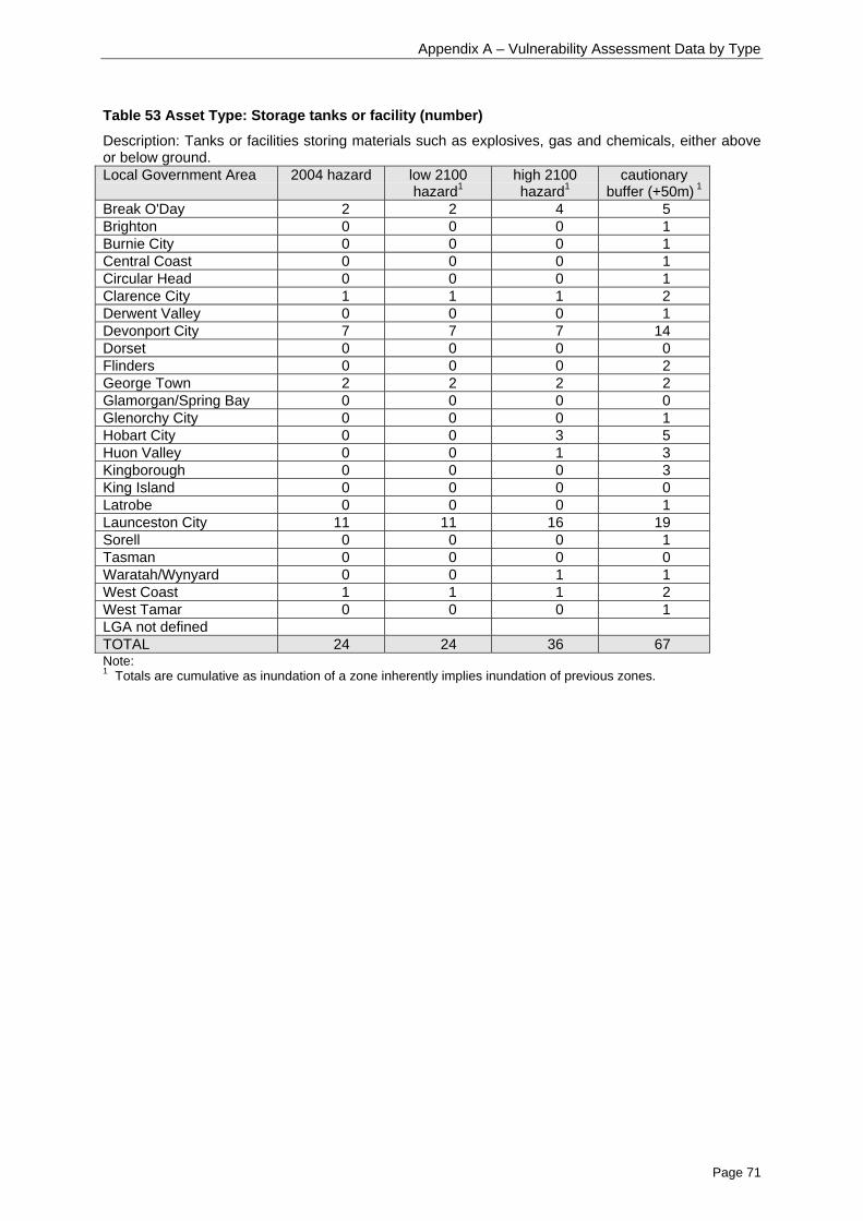
Appendix A – Vulnerability Assessment Data by Type
Page 71
Table 53 Asset Type: Storage tanks or facility (number)
Description: Tanks or facilities storing materials such as explosives, gas and chemicals, either aboveor below ground.Local Government Area 2004 hazard low 2100
hazard1high 2100hazard1
cautionarybuffer (+50m) 1
Break O'Day 2 2 4 5Brighton 0 0 0 1Burnie City 0 0 0 1Central Coast 0 0 0 1Circular Head 0 0 0 1Clarence City 1 1 1 2Derwent Valley 0 0 0 1Devonport City 7 7 7 14Dorset 0 0 0 0Flinders 0 0 0 2George Town 2 2 2 2Glamorgan/Spring Bay 0 0 0 0Glenorchy City 0 0 0 1Hobart City 0 0 3 5Huon Valley 0 0 1 3Kingborough 0 0 0 3King Island 0 0 0 0Latrobe 0 0 0 1Launceston City 11 11 16 19Sorell 0 0 0 1Tasman 0 0 0 0Waratah/Wynyard 0 0 1 1West Coast 1 1 1 2West Tamar 0 0 0 1LGA not definedTOTAL 24 24 36 67Note:1 Totals are cumulative as inundation of a zone inherently implies inundation of previous zones.

Appendix B – Vulnerability Assessment Data by Municipality
Page 72
Appendix B: Vulnerability Assessment Data – by Municipality
This Appendix details the results of a desktop audit for the amount of various assets in four hazardzones. They are listed by asset type for each coastal municipality.
(For details of each of the assets, see Appendix A).

Appendix B – Vulnerability Assessment Data by Municipality
Page 73
Table 54 Break O'Day
Asset Type 2004hazard1
low 2100hazard1
high 2100hazard1
cautionarybuffer (+50m)1
Commonwealth Land 0.11 0.11 0.11 0.11Historical Sites 0.49 0.57 0.86 6.97Natural Reserves 578.56 598.26 762.59 2326.13Other Public Land 45.02 45.62 52.08 115.03Private Reserves 48.73 49.15 53.65 62.35State Forest 0.15 0.16 0.27 6.39La
nd te
nure
(ha)
Unreserved Private 368.46 375.67 443.19 783.75Boating & Surf Life Clubs 0 0 0 0Burial Sites 0 0 0 0Camping Ground/Caravan Park 0 0 0 0Car Park 0 0 0 0Church 4 4 4 5Community Care 4 4 4 4Hall/Community Centre 3 3 3 3Cultural Area 0 0 0 0Historical 0 0 0 0Libraries 1 1 1 1Medical Services 2 2 2 2Museums/Galleries 1 1 1 1Natural 0 0 0 1Park/Reserve 2 2 2 2Picnic Area 6 6 6 12Schools 1 1 1 1Scout/Girl Guide 0 0 0 1Senior/Elderly Citizens 1 1 1 1Service Station 2 2 2 2Sports Building 0 0 0 0Sports Clubs 2 2 2 2Sports Grounds 0 0 0 0State Police/EmergencyManagement Services
4 4 4 4
Faci
litie
s(n
umbe
r)
Sewage Treatment and WasterWater plants
1 1 1 1
National/State Highway 2064 2163 2691 8398Arterial Road 3921 3957 5143 8803Feeder 1303 1436 2215 5747Access Road 16818 16818 19327 39141R
oads
(m)
Vehicular Track 10051 10145 11449 21368PWS Major Buildings 0 0 0 0PWS Minor Buildings 0 0 0 1PWS Camping Areas 1 1 1 1PWS Car Park 0 0 0 2PWS Coastal Infrastructure 0 0 0 0PWS Picnic Areas or Facilities 7 7 13 30PWS Toilet 2 2 2 20PWS Track Infrastructure 0 0 0 0PWS Road Infrastructure 0 0 0 0PWS Track (km in reserves) 3.3 3.5 5.9 17.1
PWS
asse
ts(n
umbe
r)
PWS Road (km in reserves) 0.6 0.8 0.9 1.4Waste disposal sites 0 0 0 0
EPS2
Storage tanks or facility 2 2 4 5
Note:1 Totals are cumulative as inundation of a zone inherently implies inundation of previous zones.2 EPS = Environmental permit sites (number)
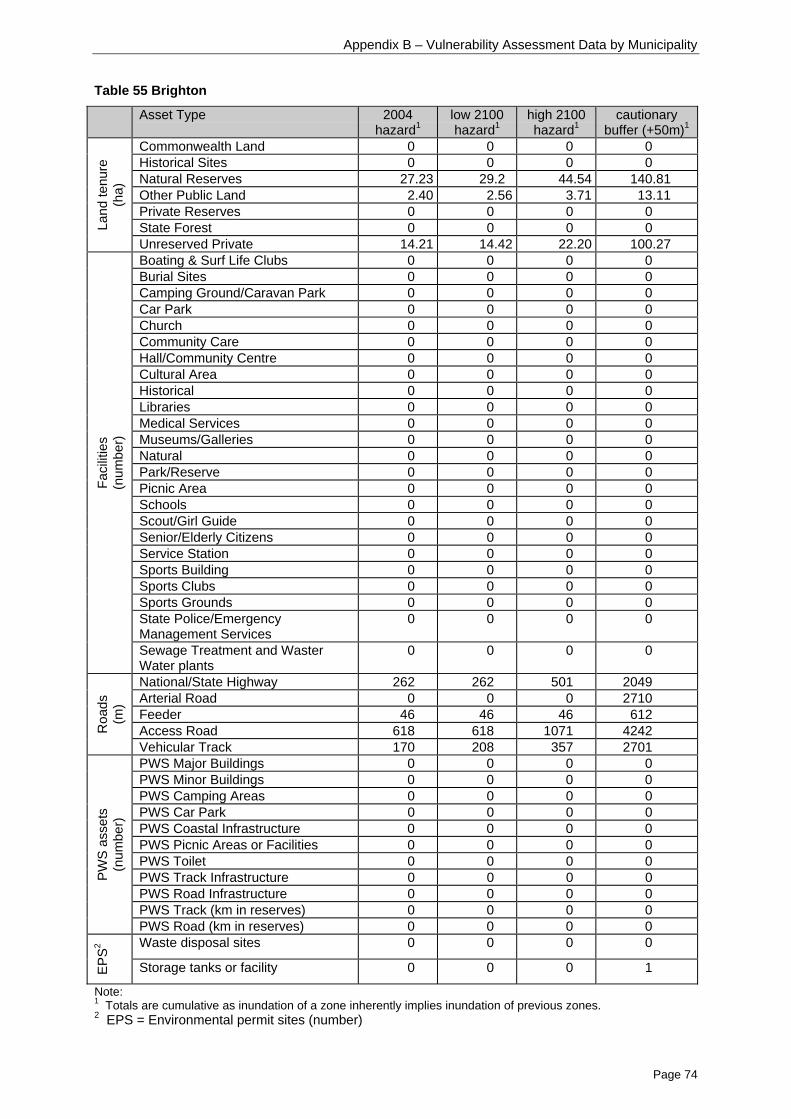
Appendix B – Vulnerability Assessment Data by Municipality
Page 74
Table 55 Brighton
Asset Type 2004hazard1
low 2100hazard1
high 2100hazard1
cautionarybuffer (+50m)1
Commonwealth Land 0 0 0 0Historical Sites 0 0 0 0Natural Reserves 27.23 29.2 44.54 140.81Other Public Land 2.40 2.56 3.71 13.11Private Reserves 0 0 0 0State Forest 0 0 0 0La
nd te
nure
(ha)
Unreserved Private 14.21 14.42 22.20 100.27Boating & Surf Life Clubs 0 0 0 0Burial Sites 0 0 0 0Camping Ground/Caravan Park 0 0 0 0Car Park 0 0 0 0Church 0 0 0 0Community Care 0 0 0 0Hall/Community Centre 0 0 0 0Cultural Area 0 0 0 0Historical 0 0 0 0Libraries 0 0 0 0Medical Services 0 0 0 0Museums/Galleries 0 0 0 0Natural 0 0 0 0Park/Reserve 0 0 0 0Picnic Area 0 0 0 0Schools 0 0 0 0Scout/Girl Guide 0 0 0 0Senior/Elderly Citizens 0 0 0 0Service Station 0 0 0 0Sports Building 0 0 0 0Sports Clubs 0 0 0 0Sports Grounds 0 0 0 0State Police/EmergencyManagement Services
0 0 0 0
Faci
litie
s(n
umbe
r)
Sewage Treatment and WasterWater plants
0 0 0 0
National/State Highway 262 262 501 2049Arterial Road 0 0 0 2710Feeder 46 46 46 612Access Road 618 618 1071 4242R
oads
(m)
Vehicular Track 170 208 357 2701PWS Major Buildings 0 0 0 0PWS Minor Buildings 0 0 0 0PWS Camping Areas 0 0 0 0PWS Car Park 0 0 0 0PWS Coastal Infrastructure 0 0 0 0PWS Picnic Areas or Facilities 0 0 0 0PWS Toilet 0 0 0 0PWS Track Infrastructure 0 0 0 0PWS Road Infrastructure 0 0 0 0PWS Track (km in reserves) 0 0 0 0
PWS
asse
ts(n
umbe
r)
PWS Road (km in reserves) 0 0 0 0Waste disposal sites 0 0 0 0
EPS2
Storage tanks or facility 0 0 0 1
Note:1 Totals are cumulative as inundation of a zone inherently implies inundation of previous zones.2 EPS = Environmental permit sites (number)

Appendix B – Vulnerability Assessment Data by Municipality
Page 75
Table 56 Burnie City
Asset Type 2004hazard1
low 2100hazard1
high 2100hazard1
cautionarybuffer (+50m)1
Commonwealth Land 0 0 0 0.04Historical Sites 0 0 0 0Natural Reserves 21.57 22.81 30.29 68.31Other Public Land 25.79 25.98 28.16 43.95Private Reserves 0 0 0 0State Forest 0 0 0 0La
nd te
nure
(ha)
Unreserved Private 9.20 9.93 15.77 47.85Boating & Surf Life Clubs 2 2 2 2Burial Sites 0 0 0 0Camping Ground/Caravan Park 0 0 0 0Car Park 1 1 1 1Church 0 0 0 0Community Care 0 0 0 0Hall/Community Centre 0 0 0 0Cultural Area 0 0 0 0Historical 0 0 0 0Libraries 0 0 0 0Medical Services 1 1 2 2Museums/Galleries 0 0 0 0Natural 0 0 0 0Park/Reserve 1 1 1 1Picnic Area 0 0 0 0Schools 0 0 1 1Scout/Girl Guide 0 0 0 0Senior/Elderly Citizens 0 0 0 0Service Station 0 0 0 6Sports Building 0 0 0 1Sports Clubs 0 0 0 2Sports Grounds 0 0 0 0State Police/EmergencyManagement Services
0 0 0 0
Faci
litie
s(n
umbe
r)
Sewage Treatment and WasterWater plants
1 1 2 2
National/State Highway 3025 3301 5867 17891Arterial Road 458 474 804 2184Feeder 18 24 86 565Access Road 5846 6257 7741 15743R
oads
(m)
Vehicular Track 353 432 538 1185PWS Major Buildings 0 0 0 0PWS Minor Buildings 0 0 0 0PWS Camping Areas 0 0 0 0PWS Car Park 0 0 0 0PWS Coastal Infrastructure 0 0 0 0PWS Picnic Areas or Facilities 0 0 0 0PWS Toilet 0 0 0 0PWS Track Infrastructure 0 0 0 0PWS Road Infrastructure 0 0 0 0PWS Track (km in reserves) 0 0 0 0
PWS
asse
ts(n
umbe
r)
PWS Road (km in reserves) 0 0 0 0Waste disposal sites 0 0 0 0
EPS2
Storage tanks or facility 0 0 0 1
Note:1 Totals are cumulative as inundation of a zone inherently implies inundation of previous zones.2 EPS = Environmental permit sites (number)
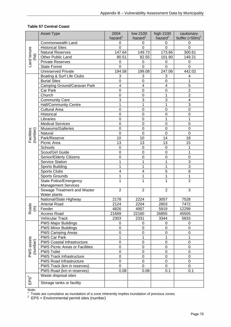
Appendix B – Vulnerability Assessment Data by Municipality
Page 76
Table 57 Central Coast
Asset Type 2004hazard1
low 2100hazard1
high 2100hazard1
cautionarybuffer (+50m)1
Commonwealth Land 0 0 0 0Historical Sites 0 0 0 0Natural Reserves 147.64 149.73 173.66 300.61Other Public Land 80.51 82.55 101.90 149.21Private Reserves 0 0 0 0State Forest 0 0 0 0La
nd te
nure
(ha)
Unreserved Private 194.58 199.08 247.06 442.02Boating & Surf Life Clubs 3 3 3 4Burial Sites 0 0 0 1Camping Ground/Caravan Park 4 4 4 5Car Park 0 0 0 2Church 0 0 1 2Community Care 3 3 3 4Hall/Community Centre 1 1 1 3Cultural Area 0 0 0 0Historical 0 0 0 0Libraries 0 0 1 1Medical Services 0 0 0 0Museums/Galleries 0 0 0 0Natural 0 0 0 0Park/Reserve 10 10 14 18Picnic Area 13 13 13 15Schools 0 0 0 1Scout/Girl Guide 0 0 0 1Senior/Elderly Citizens 0 0 0 0Service Station 1 1 1 3Sports Building 1 1 1 3Sports Clubs 4 4 5 8Sports Grounds 1 1 1 1State Police/EmergencyManagement Services
1 1 1 2
Faci
litie
s(n
umbe
r)
Sewage Treatment and WasterWater plants
2 2 2 3
National/State Highway 2178 2224 3057 7528Arterial Road 2124 2204 2803 7472Feeder 4826 4957 5919 12299Access Road 21669 22160 26855 45505R
oads
(m)
Vehicular Track 2303 2331 3344 5833PWS Major Buildings 0 0 0 0PWS Minor Buildings 0 0 0 0PWS Camping Areas 0 0 0 0PWS Car Park 1 1 1 1PWS Coastal Infrastructure 0 0 0 0PWS Picnic Areas or Facilities 0 0 0 0PWS Toilet 0 0 0 0PWS Track Infrastructure 0 0 0 0PWS Road Infrastructure 0 0 0 0PWS Track (km in reserves) 0 0 0 0
PWS
asse
ts(n
umbe
r)
PWS Road (km in reserves) 0.08 0.08 0.1 0.1Waste disposal sites
EPS2
Storage tanks or facility
Note:1 Totals are cumulative as inundation of a zone inherently implies inundation of previous zones.2 EPS = Environmental permit sites (number)

Appendix B – Vulnerability Assessment Data by Municipality
Page 77
Table 58 Circular Head
Asset Type 2004hazard1
low 2100hazard1
high 2100hazard1
cautionarybuffer (+50m)1
Commonwealth Land 0.18 0.18 0.3 3.75Historical Sites 0 0 0 0Natural Reserves 1121.87 1145.73 1377.02 4334.6Other Public Land 407.50 416.14 502.30 722.41Private Reserves 0 0.01 0.43 11.19State Forest 0.75 0.75 0.75 0.75La
nd te
nure
(ha)
Unreserved Private 5827.61 5949.08 7182.99 8513.27Boating & Surf Life Clubs 0 0 0 0Burial Sites 0 0 1 2Camping Ground/Caravan Park 1 1 1 3Car Park 0 0 0 0Church 0 0 0 0Community Care 0 0 0 1Hall/Community Centre 0 0 0 0Cultural Area 0 0 0 0Historical 0 0 0 0Libraries 0 0 0 0Medical Services 1 1 1 1Museums/Galleries 0 0 0 0Natural 0 0 0 1Park/Reserve 4 4 4 6Picnic Area 1 1 1 2Schools 2 2 2 2Scout/Girl Guide 2 2 2 2Senior/Elderly Citizens 0 0 0 0Service Station 1 1 1 1Sports Building 1 1 1 3Sports Clubs 4 4 5 5Sports Grounds 0 0 0 0State Police/EmergencyManagement Services
1 1 1 3
Faci
litie
s(n
umbe
r)
Sewage Treatment and WasterWater plants
1 1 1 2
National/State Highway 3849 4032 5214 10229Arterial Road 3873 3942 4858 5680Feeder 1429 1459 1684 1965Access Road 28266 29343 36761 49444R
oads
(m)
Vehicular Track 47760 49753 64104 102592PWS Major Buildings 0 0 0 1PWS Minor Buildings 0 0 0 2PWS Camping Areas 1 1 1 1PWS Car Park 1 1 3 8PWS Coastal Infrastructure 1 1 2 2PWS Picnic Areas or Facilities 4 4 4 4PWS Toilet 2 2 4 8PWS Track Infrastructure 1 1 1 2PWS Road Infrastructure 0 0 2 2PWS Track (km in reserves) 2.3 2.5 3.3 10.6
PWS
asse
ts(n
umbe
r)
PWS Road (km in reserves) 0 0 0 0Waste disposal sites 3 3 3 3
EPS2
Storage tanks or facility 0 0 0 1
Note:1 Totals are cumulative as inundation of a zone inherently implies inundation of previous zones.2 EPS = Environmental permit sites (number)

Appendix B – Vulnerability Assessment Data by Municipality
Page 78
Table 59 Clarence City
Asset Type 2004hazard1
low 2100hazard1
high 2100hazard1
cautionarybuffer (+50m)1
Commonwealth Land 12.8 13.78 26.16 48.9Historical Sites 0 0 0 0.71Natural Reserves 163.96 172.8 254.26 720.12Other Public Land 99.20 104.81 161.50 405.39Private Reserves 37.43 37.99 42.07 53.17State Forest 0.13 0.13 0.17 0.21La
nd te
nure
(ha)
Unreserved Private 356.32 377.38 575.28 1166.92Boating & Surf Life Clubs 0 0 1 5Burial Sites 0 0 0 0Camping Ground/Caravan Park 0 0 0 0Car Park 0 0 0 0Church 1 1 1 1Community Care 0 0 1 2Hall/Community Centre 2 2 2 3Cultural Area 0 0 0 0Historical 0 0 0 0Libraries 0 0 0 0Medical Services 0 0 1 4Museums/Galleries 0 0 0 0Natural 0 0 0 0Park/Reserve 4 4 6 15Picnic Area 4 4 7 11Schools 0 0 0 0Scout/Girl Guide 0 0 0 2Senior/Elderly Citizens 0 0 0 0Service Station 4 4 4 4Sports Building 0 0 0 1Sports Clubs 0 0 1 2Sports Grounds 0 0 0 1State Police/EmergencyManagement Services
0 0 1 3
Faci
litie
s(n
umbe
r)
Sewage Treatment and WasterWater plants
0 0 0 1
National/State Highway 735 798 1043 2879Arterial Road 4937 4989 5955 8167Feeder 3146 3259 4908 7726Access Road 17879 19178 31225 66900R
oads
(m)
Vehicular Track 3892 4291 6593 15493PWS Major Buildings 0 0 1 1PWS Minor Buildings 1 1 2 4PWS Camping Areas 0 0 0 0PWS Car Park 2 2 4 6PWS Coastal Infrastructure 0 0 0 0PWS Picnic Areas or Facilities 4 4 4 4PWS Toilet 3 3 6 6PWS Track Infrastructure 1 1 1 2PWS Road Infrastructure 4 4 10 11PWS Track (km in reserves) 0 0 7 9.7
PWS
asse
ts(n
umbe
r)
PWS Road (km in reserves) 0.2 0.2 0.5 1.0Waste disposal sites 0 0 0 0
EPS2
Storage tanks or facility 1 1 1 2
Note:1 Totals are cumulative as inundation of a zone inherently implies inundation of previous zones.2 EPS = Environmental permit sites (number)

Appendix B – Vulnerability Assessment Data by Municipality
Page 79
Table 60 Derwent Valley
Asset Type 2004hazard1
low 2100hazard1
high 2100hazard1
cautionarybuffer (+50m)1
Commonwealth Land 0 0 0.02 1.19Historical Sites 0 0 0.06 0.06Natural Reserves 20.35 20.81 27.41 202.21Other Public Land 4.22 4.41 6.27 18.50Private Reserves 0 0 0 0State Forest 0 0 0 0La
nd te
nure
(ha)
Unreserved Private 34.02 35.76 57.55 171.13Boating & Surf Life Clubs 0 0 0 2Burial Sites 0 0 0 0Camping Ground/Caravan Park 1 1 1 1Car Park 0 0 0 0Church 0 0 0 0Community Care 0 0 0 0Hall/Community Centre 0 0 0 1Cultural Area 0 0 1 1Historical 0 0 0 0Libraries 0 0 0 0Medical Services 0 0 0 0Museums/Galleries 0 0 0 0Natural 0 0 0 0Park/Reserve 1 1 2 3Picnic Area 0 0 2 3Schools 0 0 0 0Scout/Girl Guide 0 0 0 0Senior/Elderly Citizens 0 0 0 0Service Station 0 0 0 0Sports Building 1 1 1 2Sports Clubs 0 0 0 2Sports Grounds 0 0 0 0State Police/EmergencyManagement Services
0 0 0 0
Faci
litie
s(n
umbe
r)
Sewage Treatment and WasterWater plants
0 0 0 0
National/State Highway 1041 1095 1811 8064Arterial Road 396 429 636 2318Feeder 0 0 0 0Access Road 695 698 1406 7077R
oads
(m)
Vehicular Track 26 26 61 560PWS Major Buildings 0 0 0 0PWS Minor Buildings 0 0 0 0PWS Camping Areas 0 0 0 0PWS Car Park 0 0 0 0PWS Coastal Infrastructure 0 0 0 0PWS Picnic Areas or Facilities 0 0 0 0PWS Toilet 0 0 0 0PWS Track Infrastructure 0 0 0 0PWS Road Infrastructure 0 0 0 0PWS Track (km in reserves) 0 0 0 0
PWS
asse
ts(n
umbe
r)
PWS Road (km in reserves) 0 0 0 0Waste disposal sites 0 0 0 0
EPS2
Storage tanks or facility 0 0 0 1
Note:1 Totals are cumulative as inundation of a zone inherently implies inundation of previous zones.2 EPS = Environmental permit sites (number)
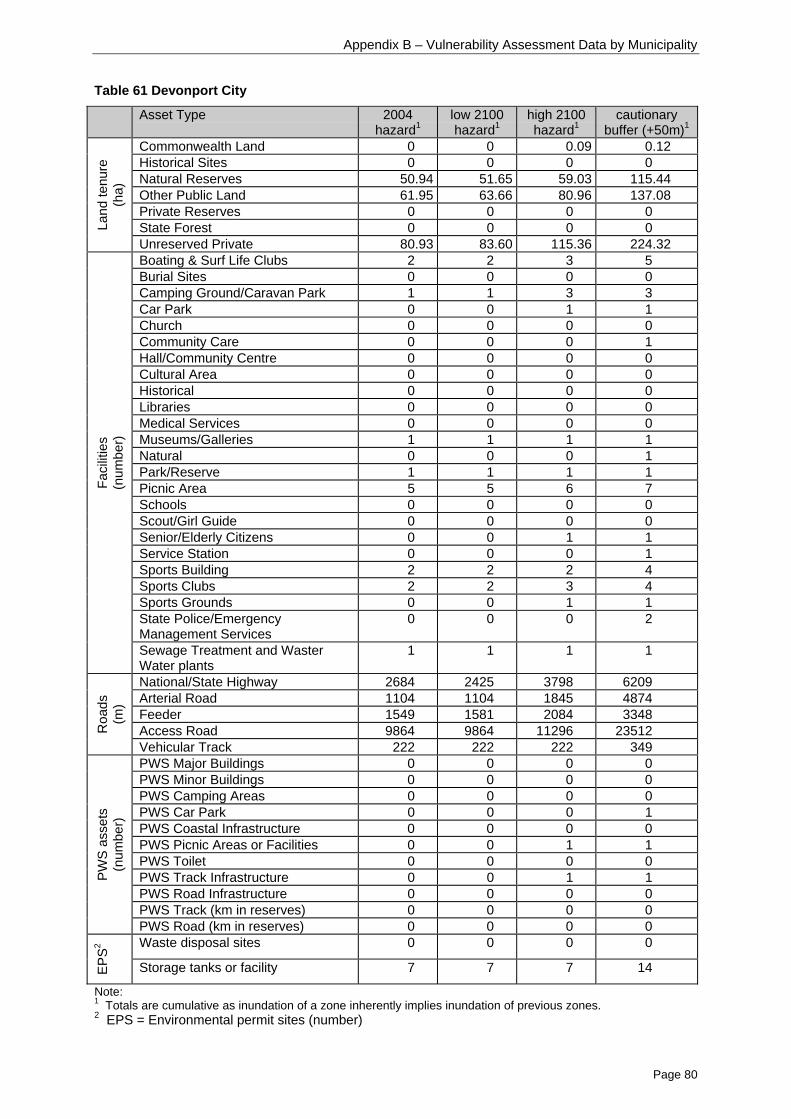
Appendix B – Vulnerability Assessment Data by Municipality
Page 80
Table 61 Devonport City
Asset Type 2004hazard1
low 2100hazard1
high 2100hazard1
cautionarybuffer (+50m)1
Commonwealth Land 0 0 0.09 0.12Historical Sites 0 0 0 0Natural Reserves 50.94 51.65 59.03 115.44Other Public Land 61.95 63.66 80.96 137.08Private Reserves 0 0 0 0State Forest 0 0 0 0La
nd te
nure
(ha)
Unreserved Private 80.93 83.60 115.36 224.32Boating & Surf Life Clubs 2 2 3 5Burial Sites 0 0 0 0Camping Ground/Caravan Park 1 1 3 3Car Park 0 0 1 1Church 0 0 0 0Community Care 0 0 0 1Hall/Community Centre 0 0 0 0Cultural Area 0 0 0 0Historical 0 0 0 0Libraries 0 0 0 0Medical Services 0 0 0 0Museums/Galleries 1 1 1 1Natural 0 0 0 1Park/Reserve 1 1 1 1Picnic Area 5 5 6 7Schools 0 0 0 0Scout/Girl Guide 0 0 0 0Senior/Elderly Citizens 0 0 1 1Service Station 0 0 0 1Sports Building 2 2 2 4Sports Clubs 2 2 3 4Sports Grounds 0 0 1 1State Police/EmergencyManagement Services
0 0 0 2
Faci
litie
s(n
umbe
r)
Sewage Treatment and WasterWater plants
1 1 1 1
National/State Highway 2684 2425 3798 6209Arterial Road 1104 1104 1845 4874Feeder 1549 1581 2084 3348Access Road 9864 9864 11296 23512R
oads
(m)
Vehicular Track 222 222 222 349PWS Major Buildings 0 0 0 0PWS Minor Buildings 0 0 0 0PWS Camping Areas 0 0 0 0PWS Car Park 0 0 0 1PWS Coastal Infrastructure 0 0 0 0PWS Picnic Areas or Facilities 0 0 1 1PWS Toilet 0 0 0 0PWS Track Infrastructure 0 0 1 1PWS Road Infrastructure 0 0 0 0PWS Track (km in reserves) 0 0 0 0
PWS
asse
ts(n
umbe
r)
PWS Road (km in reserves) 0 0 0 0Waste disposal sites 0 0 0 0
EPS2
Storage tanks or facility 7 7 7 14
Note:1 Totals are cumulative as inundation of a zone inherently implies inundation of previous zones.2 EPS = Environmental permit sites (number)

Appendix B – Vulnerability Assessment Data by Municipality
Page 81
Table 62 Dorset
Asset Type 2004hazard1
low 2100hazard1
high 2100hazard1
cautionarybuffer (+50m)1
Commonwealth Land 0 0 0 0Historical Sites 0 0 0 0Natural Reserves 664.78 681.04 846.56 2141.5Other Public Land 77.74 79.69 97.58 203.00Private Reserves 17.24 17.94 25.17 58.77State Forest 0 0 0 0La
nd te
nure
(ha)
Unreserved Private 297.75 311.48 447.04 791.03Boating & Surf Life Clubs 0 0 0 1Burial Sites 0 0 0 0Camping Ground/Caravan Park 0 0 0 2Car Park 0 0 0 0Church 0 0 0 0Community Care 0 0 0 0Hall/Community Centre 0 0 0 0Cultural Area 0 0 0 0Historical 0 0 0 0Libraries 0 0 0 0Medical Services 0 0 0 0Museums/Galleries 0 0 0 0Natural 0 0 0 0Park/Reserve 0 0 1 1Picnic Area 0 0 0 2Schools 0 0 0 0Scout/Girl Guide 0 0 0 0Senior/Elderly Citizens 0 0 0 0Service Station 0 0 0 0Sports Building 0 0 0 0Sports Clubs 0 0 0 0Sports Grounds 0 0 0 0State Police/EmergencyManagement Services
0 0 0 0
Faci
litie
s(n
umbe
r)
Sewage Treatment and WasterWater plants
0 0 0 0
National/State Highway 0 0 0 0Arterial Road 1044 1076 1382 1543Feeder 0 0 376 1085Access Road 1967 2069 3378 6906R
oads
(m)
Vehicular Track 7342 7879 12604 17673PWS Major Buildings 0 0 0 0PWS Minor Buildings 0 0 0 0PWS Camping Areas 2 2 5 12PWS Car Park 1 1 2 2PWS Coastal Infrastructure 1 1 1 1PWS Picnic Areas or Facilities 4 6 17 47PWS Toilet 4 4 10 17PWS Track Infrastructure 0 0 0 0PWS Road Infrastructure 1 1 1 1PWS Track (km in reserves) 0 0 0 .05
PWS
asse
ts(n
umbe
r)
PWS Road (km in reserves) 0.6 0.7 1.0 2.2Waste disposal sites 0 0 0 0
EPS2
Storage tanks or facility 0 0 0 0
Note:1 Totals are cumulative as inundation of a zone inherently implies inundation of previous zones.2 EPS = Environmental permit sites (number)
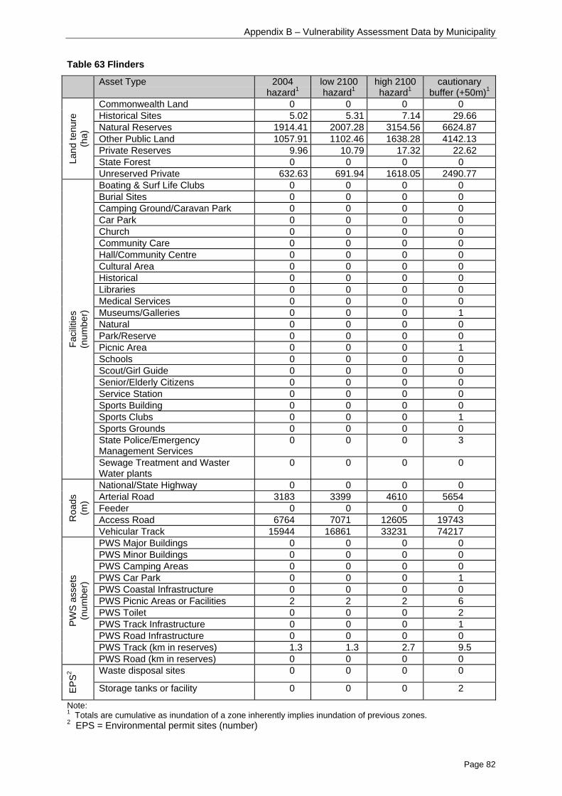
Appendix B – Vulnerability Assessment Data by Municipality
Page 82
Table 63 Flinders
Asset Type 2004hazard1
low 2100hazard1
high 2100hazard1
cautionarybuffer (+50m)1
Commonwealth Land 0 0 0 0Historical Sites 5.02 5.31 7.14 29.66Natural Reserves 1914.41 2007.28 3154.56 6624.87Other Public Land 1057.91 1102.46 1638.28 4142.13Private Reserves 9.96 10.79 17.32 22.62State Forest 0 0 0 0La
nd te
nure
(ha)
Unreserved Private 632.63 691.94 1618.05 2490.77Boating & Surf Life Clubs 0 0 0 0Burial Sites 0 0 0 0Camping Ground/Caravan Park 0 0 0 0Car Park 0 0 0 0Church 0 0 0 0Community Care 0 0 0 0Hall/Community Centre 0 0 0 0Cultural Area 0 0 0 0Historical 0 0 0 0Libraries 0 0 0 0Medical Services 0 0 0 0Museums/Galleries 0 0 0 1Natural 0 0 0 0Park/Reserve 0 0 0 0Picnic Area 0 0 0 1Schools 0 0 0 0Scout/Girl Guide 0 0 0 0Senior/Elderly Citizens 0 0 0 0Service Station 0 0 0 0Sports Building 0 0 0 0Sports Clubs 0 0 0 1Sports Grounds 0 0 0 0State Police/EmergencyManagement Services
0 0 0 3
Faci
litie
s(n
umbe
r)
Sewage Treatment and WasterWater plants
0 0 0 0
National/State Highway 0 0 0 0Arterial Road 3183 3399 4610 5654Feeder 0 0 0 0Access Road 6764 7071 12605 19743R
oads
(m)
Vehicular Track 15944 16861 33231 74217PWS Major Buildings 0 0 0 0PWS Minor Buildings 0 0 0 0PWS Camping Areas 0 0 0 0PWS Car Park 0 0 0 1PWS Coastal Infrastructure 0 0 0 0PWS Picnic Areas or Facilities 2 2 2 6PWS Toilet 0 0 0 2PWS Track Infrastructure 0 0 0 1PWS Road Infrastructure 0 0 0 0PWS Track (km in reserves) 1.3 1.3 2.7 9.5
PWS
asse
ts(n
umbe
r)
PWS Road (km in reserves) 0 0 0 0Waste disposal sites 0 0 0 0
EPS2
Storage tanks or facility 0 0 0 2
Note:1 Totals are cumulative as inundation of a zone inherently implies inundation of previous zones.2 EPS = Environmental permit sites (number)

Appendix B – Vulnerability Assessment Data by Municipality
Page 83
Table 64 George Town
Asset Type 2004hazard1
low 2100hazard1
high 2100hazard1
cautionarybuffer (+50m)1
Commonwealth Land 8.02 8.45 11.56 59.78Historical Sites 2.35 2.35 2.68 13.47Natural Reserves 115.22 118.17 143.9 375.48Other Public Land 58.80 61.04 79.53 191.03Private Reserves 1.48 1.59 2.68 40.48State Forest 0 0 0 0La
nd te
nure
(ha)
Unreserved Private 129.54 134.81 183.95 488.00Boating & Surf Life Clubs 2 2 2 2Burial Sites 0 0 0 0Camping Ground/Caravan Park 0 0 1 1Car Park 0 0 0 0Church 2 2 3 4Community Care 0 0 0 1Hall/Community Centre 1 1 1 3Cultural Area 0 0 0 0Historical 0 0 0 0Libraries 0 0 0 0Medical Services 0 0 0 0Museums/Galleries 1 1 1 1Natural 0 0 0 0Park/Reserve 1 1 2 2Picnic Area 2 2 2 2Schools 0 0 0 0Scout/Girl Guide 0 0 0 0Senior/Elderly Citizens 0 0 0 1Service Station 0 0 0 1Sports Building 0 0 0 1Sports Clubs 1 1 1 3Sports Grounds 0 0 0 0State Police/EmergencyManagement Services
0 0 0 1
Faci
litie
s(n
umbe
r)
Sewage Treatment and WasterWater plants
0 0 0 0
National/State Highway 41 41 29 657Arterial Road 2289 2401 2998 3797Feeder 117 124 163 668Access Road 14237 14490 17801 33861R
oads
(m)
Vehicular Track 2704 2779 3616 11717PWS Major Buildings 6 6 7 7PWS Minor Buildings 14 14 15 15PWS Camping Areas 0 0 0 0PWS Car Park 3 3 3 3PWS Coastal Infrastructure 0 0 0 0PWS Picnic Areas or Facilities 0 0 0 0PWS Toilet 10 10 10 10PWS Track Infrastructure 0 0 0 0PWS Road Infrastructure 2 2 2 2PWS Track (km in reserves) 0 0 0 0
PWS
asse
ts(n
umbe
r)
PWS Road (km in reserves) 0.7 0.7 0.8 1.2Waste disposal sites 0 0 0 0
EPS2
Storage tanks or facility 2 2 2 2
Note:1 Totals are cumulative as inundation of a zone inherently implies inundation of previous zones.2 EPS = Environmental permit sites (number)

Appendix B – Vulnerability Assessment Data by Municipality
Page 84
Table 65 Glamorgan/Spring Bay
Asset Type 2004hazard1
low 2100hazard1
high 2100hazard1
cautionarybuffer (+50m)1
Commonwealth Land 0 0 0 0.01Historical Sites 0 0 0 0Natural Reserves 638.17 660.69 875.19 2577Other Public Land 47.91 48.97 60.00 121.39Private Reserves 384.40 391.46 454.72 538.96State Forest 0 0 0 0La
nd te
nure
(ha)
Unreserved Private 692.04 722.29 1031.40 2014.99Boating & Surf Life Clubs 0 0 0 0Burial Sites 2 2 2 2Camping Ground/Caravan Park 1 1 2 6Car Park 0 0 0 0Church 0 0 0 0Community Care 0 0 0 0Hall/Community Centre 0 0 0 1Cultural Area 0 0 1 2Historical 1 1 1 1Libraries 0 0 0 0Medical Services 1 1 1 1Museums/Galleries 0 0 0 0Natural 1 1 1 2Park/Reserve 0 0 1 2Picnic Area 4 4 5 11Schools 0 0 0 0Scout/Girl Guide 0 0 0 1Senior/Elderly Citizens 0 0 0 0Service Station 0 0 0 2Sports Building 1 1 1 3Sports Clubs 2 2 2 6Sports Grounds 0 0 0 0State Police/EmergencyManagement Services
2 2 2 3
Faci
litie
s(n
umbe
r)
Sewage Treatment and WasterWater plants
0 0 1 1
National/State Highway 1095 1295 3158 10315Arterial Road 0 0 5 1630Feeder 201 208 435 1426Access Road 14068 14892 21837 46452R
oads
(m)
Vehicular Track 20506 21502 31378 49595PWS Major Buildings 1 1 1 1PWS Minor Buildings 4 4 5 8PWS Camping Areas 2 2 3 10PWS Car Park 1 2 3 13PWS Coastal Infrastructure 0 0 0 0PWS Picnic Areas or Facilities 0 0 1 7PWS Toilet 2 2 6 19PWS Track Infrastructure 2 2 2 6PWS Road Infrastructure 2 2 3 9PWS Track (km in reserves) 5.5 5.9 9.7 20.9
PWS
asse
ts(n
umbe
r)
PWS Road (km in reserves) 0.2 0.2 0.8 1.5Waste disposal sites 0 0 0 0
EPS2
Storage tanks or facility 0 0 0 0
Note:1 Totals are cumulative as inundation of a zone inherently implies inundation of previous zones.2 EPS = Environmental permit sites (number)

Appendix B – Vulnerability Assessment Data by Municipality
Page 85
Table 66 Glenorchy City
Asset Type 2004hazard1
low 2100hazard1
high 2100hazard1
cautionarybuffer (+50m)1
Commonwealth Land 0.45 0.55 0.93 5.46Historical Sites 0 0 0 0Natural Reserves 2.24 2.32 2.77 17.12Other Public Land 23.02 24.02 33.73 84.98Private Reserves 0 0 0 0State Forest 0 0 0 0La
nd te
nure
(ha)
Unreserved Private 20.48 21.71 33.80 137.74Boating & Surf Life Clubs 2 2 3 4Burial Sites 0 0 0 0Camping Ground/Caravan Park 1 1 1 1Car Park 0 0 0 0Church 0 0 0 0Community Care 0 0 0 1Hall/Community Centre 0 0 0 1Cultural Area 0 0 0 0Historical 0 0 0 1Libraries 0 0 0 0Medical Services 0 0 0 0Museums/Galleries 0 0 0 1Natural 0 0 0 0Park/Reserve 2 2 5 10Picnic Area 1 1 3 3Schools 0 0 0 0Scout/Girl Guide 0 0 0 1Senior/Elderly Citizens 0 0 0 0Service Station 0 0 0 1Sports Building 0 0 0 2Sports Clubs 0 0 0 3Sports Grounds 0 0 0 1State Police/EmergencyManagement Services
0 0 0 0
Faci
litie
s(n
umbe
r)
Sewage Treatment and WasterWater plants
0 0 0 1
National/State Highway 1387 1417 1608 2151Arterial Road 375 380 797 4904Feeder 85 96 172 479Access Road 3058 3312 5253 18452R
oads
(m)
Vehicular Track 375 387 492 1827PWS Major Buildings 0 0 0 0PWS Minor Buildings 0 0 0 0PWS Camping Areas 0 0 0 0PWS Car Park 0 0 0 0PWS Coastal Infrastructure 0 0 0 0PWS Picnic Areas or Facilities 0 0 0 0PWS Toilet 0 0 0 0PWS Track Infrastructure 0 0 0 0PWS Road Infrastructure 0 0 0 0PWS Track (km in reserves) 0 0 .02 .5
PWS
asse
ts(n
umbe
r)
PWS Road (km in reserves) 0 0 0 0Waste disposal sites 0 0 0 0
EPS2
Storage tanks or facility 0 0 0 1
Note:1 Totals are cumulative as inundation of a zone inherently implies inundation of previous zones.2 EPS = Environmental permit sites (number)

Appendix B – Vulnerability Assessment Data by Municipality
Page 86
Table 67 Hobart City
Asset Type 2004hazard1
low 2100hazard1
high 2100hazard1
cautionarybuffer (+50m)1
Commonwealth Land 0.61 0.61 0.95 2.66Historical Sites 0 0 0 0Natural Reserves 0.10 0.1 0.4 1.33Other Public Land 25.90 27.16 34.89 78.09Private Reserves 0 0 0 0State Forest 0 0 0 0La
nd te
nure
(ha)
Unreserved Private 5.34 6.01 10.32 41.93Boating & Surf Life Clubs 2 2 2 10Burial Sites 0 0 0 0Camping Ground/Caravan Park 0 0 0 0Car Park 2 2 2 3Church 0 0 0 1Community Care 0 0 0 1Hall/Community Centre 0 0 0 1Cultural Area 0 0 2 2Historical 0 0 0 1Libraries 0 0 0 0Medical Services 0 0 1 1Museums/Galleries 0 0 0 2Natural 0 0 0 0Park/Reserve 1 1 2 6Picnic Area 0 0 1 2Schools 0 0 0 0Scout/Girl Guide 1 1 2 2Senior/Elderly Citizens 0 0 0 0Service Station 0 0 0 0Sports Building 3 3 3 13Sports Clubs 0 0 0 0Sports Grounds 0 0 0 1State Police/EmergencyManagement Services
0 0 0 0
Faci
litie
s(n
umbe
r)
Sewage Treatment and WasterWater plants
0 0 0 1
National/State Highway 305 310 432 3146Arterial Road 175 184 328 2328Feeder 64 78 317 2022Access Road 2238 2328 3492 10619R
oads
(m)
Vehicular Track 191 241 363 557PWS Major Buildings 0 0 0 0PWS Minor Buildings 0 0 0 0PWS Camping Areas 0 0 0 0PWS Car Park 0 0 0 0PWS Coastal Infrastructure 0 0 0 0PWS Picnic Areas or Facilities 0 0 0 0PWS Toilet 0 0 0 0PWS Track Infrastructure 0 0 0 0PWS Road Infrastructure 0 0 0 0PWS Track (km in reserves) 0 0 0 0
PWS
asse
ts(n
umbe
r)
PWS Road (km in reserves) 0 0 0 0Waste disposal sites 0 0 0 0
EPS2
Storage tanks or facility 0 0 3 5
Note:1 Totals are cumulative as inundation of a zone inherently implies inundation of previous zones.2 EPS = Environmental permit sites (number)

Appendix B – Vulnerability Assessment Data by Municipality
Page 87
Table 68 Huon Valley
Asset Type 2004hazard1
low 2100hazard1
high 2100hazard1
cautionarybuffer (+50m)1
Commonwealth Land 0 0 0 0Historical Sites 0.8 0.92 1.46 9.95Natural Reserves 1408.88 1465.06 2004.02 6616.71Other Public Land 116.00 116.36 121.89 177.08Private Reserves 0.24 0.24 0.28 2.70State Forest 7.99 8.52 13.83 62.97La
nd te
nure
(ha)
Unreserved Private 221.94 226.93 273.94 819.87Boating & Surf Life Clubs 2 2 3 3Burial Sites 0 0 0 1Camping Ground/Caravan Park 0 0 0 1Car Park 0 0 0 0Church 0 0 0 0Community Care 0 0 0 1Hall/Community Centre 0 0 1 1Cultural Area 0 0 0 1Historical 0 0 0 0Libraries 0 0 0 0Medical Services 0 0 0 1Museums/Galleries 0 0 0 2Natural 1 1 1 1Park/Reserve 2 2 2 4Picnic Area 2 2 5 8Schools 0 0 1 1Scout/Girl Guide 0 0 0 0Senior/Elderly Citizens 0 0 0 0Service Station 0 0 0 3Sports Building 1 1 1 4Sports Clubs 1 1 1 3Sports Grounds 0 0 0 1State Police/EmergencyManagement Services
0 0 0 1
Faci
litie
s(n
umbe
r)
Sewage Treatment and WasterWater plants
0 0 0 1
National/State Highway 2218 2362 3869 21910Arterial Road 1006 1040 1516 4738Feeder 949 1157 2201 20109Access Road 5258 5698 10126 48066R
oads
(m)
Vehicular Track 2242 2490 3629 14129PWS Major Buildings 2 2 2 2PWS Minor Buildings 3 3 5 6PWS Camping Areas 6 6 8 14PWS Car Park 0 0 0 0PWS Coastal Infrastructure 2 2 3 4PWS Picnic Areas or Facilities 0 0 1 1PWS Toilet 5 5 7 14PWS Track Infrastructure 0 0 0 1PWS Road Infrastructure 1 1 1 2PWS Track (km in reserves) 8 8.4 10.6 27
PWS
asse
ts(n
umbe
r)
PWS Road (km in reserves) 0.6 0.6 0.9 0.9Waste disposal sites 0 0 0 1
EPS2
Storage tanks or facility 0 0 1 3
Note:1 Totals are cumulative as inundation of a zone inherently implies inundation of previous zones.2 EPS = Environmental permit sites (number)

Appendix B – Vulnerability Assessment Data by Municipality
Page 88
Table 69 Kingborough
Asset Type 2004hazard1
low 2100hazard1
high 2100hazard1
cautionarybuffer (+50m)1
Commonwealth Land 0 0 0 0Historical Sites 0.18 0.18 0.22 0.83Natural Reserves 212.64 221.66 301.92 1328.76Other Public Land 32.11 32.85 40.02 98.60Private Reserves 17.76 18.01 20.09 55.91State Forest 0 0 0 0.75La
nd te
nure
(ha)
Unreserved Private 145.19 152.24 223.66 933.56Boating & Surf Life Clubs 0 0 1 3Burial Sites 0Camping Ground/Caravan Park 2 2 2 3Car Park 0Church 1 1Community Care 1 1 1 2Hall/Community Centre 0 0 0 5Cultural Area 0Historical 1 1 1 3Libraries 0 0 0 0Medical Services 0 0 0 1Museums/Galleries 0 0 0 2Natural 0 0 0 0Park/Reserve 1 1 1 5Picnic Area 4 4 4 11Schools 0 0 0 1Scout/Girl Guide 0 0 0 1Senior/Elderly Citizens 0 0 0 0Service Station 0 0 2 5Sports Building 2 2 3 4Sports Clubs 1 1 2 5Sports Grounds 0 0 1 2State Police/EmergencyManagement Services
0 0 0 3
Faci
litie
s(n
umbe
r)
Sewage Treatment and WasterWater plants
0 0 0 1
National/State Highway 615 677 1187 7824Arterial Road 2956 3007 3885 8706Feeder 2648 2648 3829 9920Access Road 10560 10614 13942 48126R
oads
(m)
Vehicular Track 3084 3207 6392 22425PWS Major Buildings 0 0 0 1PWS Minor Buildings 1 1 1 2PWS Camping Areas 1 1 1 1PWS Car Park 0 1 1 5PWS Coastal Infrastructure 0 0 0 0PWS Picnic Areas or Facilities 1 1 1 1PWS Toilet 3 3 3 5PWS Track Infrastructure 1 1 2 2PWS Road Infrastructure 0 0 0 0PWS Track (km in reserves) 1 1.1 1.4 8.4
PWS
asse
ts(n
umbe
r)
PWS Road (km in reserves) 0 0 0 0Waste disposal sites 0 0 0 0
EPS2
Storage tanks or facility 0 0 0 3
Note:1 Totals are cumulative as inundation of a zone inherently implies inundation of previous zones.2 EPS = Environmental permit sites (number)

Appendix B – Vulnerability Assessment Data by Municipality
Page 89
Table 70 King Island
Asset Type 2004hazard1
low 2100hazard1
high 2100hazard1
cautionarybuffer (+50m)1
Commonwealth Land 0 0 0 0Historical Sites 0 0 0 0Natural Reserves 293.22 305.53 460.28 1435.41Other Public Land 28.31 29.36 37.25 105.91Private Reserves 0 0 0 0State Forest 0 0 0 0La
nd te
nure
(ha)
Unreserved Private 56.66 59.04 80.78 478.12Boating & Surf Life Clubs 0 0 0 0Burial Sites 0 0 0 0Camping Ground/Caravan Park 0 0 0 0Car Park 0 0 0 0Church 0 0 0 0Community Care 0 0 0 0Hall/Community Centre 0 0 0 0Cultural Area 0 0 0 0Historical 0 0 0 0Libraries 0 0 0 0Medical Services 0 0 0 0Museums/Galleries 0 0 0 0Natural 0 0 0 0Park/Reserve 0 0 0 1Picnic Area 0 0 0 1Schools 0 0 0 0Scout/Girl Guide 0 0 0 0Senior/Elderly Citizens 0 0 0 0Service Station 0 0 0 0Sports Building 0 0 0 0Sports Clubs 0 0 0 0Sports Grounds 0 0 0 0State Police/EmergencyManagement Services
0 0 0 1
Faci
litie
s(n
umbe
r)
Sewage Treatment and WasterWater plants
1 1 1 1
National/State Highway 0 0 0 0Arterial Road 101 120 479 1328Feeder 0 0 0 0Access Road 4330 4415 5863 14603R
oads
(m)
Vehicular Track 7313 7682 10932 35515PWS Major Buildings 0 0 0 0PWS Minor Buildings 0 0 0 0PWS Camping Areas 0 0 0 0PWS Car Park 0 0 0 0PWS Coastal Infrastructure 0 0 0 0PWS Picnic Areas or Facilities 0 0 0 0PWS Toilet 1 1 1 1PWS Track Infrastructure 0 0 0 0PWS Road Infrastructure 0 0 0 0PWS Track (km in reserves) 0.05 .07 .2 .6
PWS
asse
ts(n
umbe
r)
PWS Road (km in reserves) 0 0 0 0Waste disposal sites 0 0 0 0
EPS2
Storage tanks or facility 0 0 0 0
Note:1 Totals are cumulative as inundation of a zone inherently implies inundation of previous zones.2 EPS = Environmental permit sites (number)

Appendix B – Vulnerability Assessment Data by Municipality
Page 90
Table 71 Latrobe
Asset Type 2004hazard1
low 2100hazard1
high 2100hazard1
cautionarybuffer (+50m)1
Commonwealth Land 0.29 0.29 0.29 0.39Historical SitesNatural Reserves 356.11 363.5 416.37 801.7Other Public Land 59.29 61.32 79.21 115.16Private ReservesState Forest 2.31 2.34 3.04 12.78La
nd te
nure
(ha)
Unreserved Private 340.84 348.98 415.24 677.23Boating & Surf Life Clubs 0 0 0 0Burial Sites 0 0 0 0Camping Ground/Caravan Park 3 3 3 3Car Park 0 0 0 0Church 2 2 2 2Community Care 0 0 0 0Hall/Community Centre 1 1 1 1Cultural Area 0 0 0 0Historical 0 0 0 0Libraries 0 0 0 0Medical Services 0 0 0 0Museums/Galleries 0 0 0 0Natural 0 0 0 0Park/Reserve 0 0 0 2Picnic Area 5 5 5 5Schools 0 0 0 0Scout/Girl Guide 1 1 1 1Senior/Elderly Citizens 0 0 0 0Service Station 0 0 0 0Sports Building 0 0 0 0Sports Clubs 2 2 2 2Sports Grounds 0 0 0 0State Police/EmergencyManagement Services
1 1 1 2
Faci
litie
s(n
umbe
r)
Sewage Treatment and WasterWater plants
0 0 0 1
National/State Highway 0 0 0 0Arterial Road 1173 1180 1288 2194Feeder 879 959 1318 4206Access Road 19276 19276 20999 26405R
oads
(m)
Vehicular Track 2500 2514 3410 8070PWS Major Buildings 0 0 0 0PWS Minor Buildings 1 1 1 2PWS Camping Areas 1 1 3 3PWS Car Park 4 4 5 6PWS Coastal Infrastructure 0 0 0 0PWS Picnic Areas or Facilities 48 49 62 66PWS Toilet 3 3 3 4PWS Track Infrastructure 0 0 1 1PWS Road Infrastructure 3 3 3 3PWS Track (km in reserves) 0.1 0.1 0 0
PWS
asse
ts(n
umbe
r)
PWS Road (km in reserves) 1.1 1.2 1.4 2.0Waste disposal sites 0 0 0 0
EPS2
Storage tanks or facility 0 0 0 1
Note:1 Totals are cumulative as inundation of a zone inherently implies inundation of previous zones.2 EPS = Environmental permit sites (number)

Appendix B – Vulnerability Assessment Data by Municipality
Page 91
Table 72 Launceston City
Asset Type 2004hazard1
low 2100hazard1
high 2100hazard1
cautionarybuffer (+50m)1
Commonwealth Land 0.04 0.04 0.43 0.59Historical Sites 0 0 0 0Natural Reserves 45.52 46.24 51.39 211.9Other Public Land 48.39 49.30 57.07 76.94Private Reserves 0 0 0 0State Forest 0 0 0 0La
nd te
nure
(ha)
Unreserved Private 313.93 322.32 401.23 562.36Boating & Surf Life Clubs 2 2 3 3Burial Sites 0 0 0 0Camping Ground/Caravan Park 0 0 0 0Car Park 3 3 3 3Church 0 0 1 3Community Care 2 2 4 4Hall/Community Centre 0 0 0 0Cultural Area 0 0 0 0Historical 0 0 0 1Libraries 0 0 0 0Medical Services 0 0 0 0Museums/Galleries 0 0 0 2Natural 0 0 0 0Park/Reserve 1 1 2 2Picnic Area 1 1 1 1Schools 1 1 1 2Scout/Girl Guide 2 2 2 2Senior/Elderly Citizens 0 0 1 1Service Station 1 1 1 2Sports Building 1 1 2 3Sports Clubs 3 3 4 4Sports Grounds 1 1 1 1State Police/EmergencyManagement Services
0 0 0 0
Faci
litie
s(n
umbe
r)
Sewage Treatment and WasterWater plants
1 1 1 1
National/State Highway 5473 5586 7075 11457Arterial Road 3166 3203 4297 6841Feeder 0 0 156 674Access Road 19559 20073 26776 33498R
oads
(m)
Vehicular Track 1465 1484 1714 3147PWS Major Buildings 0 0 0 0PWS Minor Buildings 0 0 0 0PWS Camping Areas 0 0 0 0PWS Car Park 0 0 0 0PWS Coastal Infrastructure 0 0 0 0PWS Picnic Areas or Facilities 0 0 0 0PWS Toilet 0 0 0 0PWS Track Infrastructure 0 0 0 0PWS Road Infrastructure 0 0 0 0PWS Track (km in reserves) 0 0 0 0.1
PWS
asse
ts(n
umbe
r)
PWS Road (km in reserves) 0 0 0 0Waste disposal sites 0 0 0 0
EPS2
Storage tanks or facility 11 11 16 19
Note:1 Totals are cumulative as inundation of a zone inherently implies inundation of previous zones.2 EPS = Environmental permit sites (number)

Appendix B – Vulnerability Assessment Data by Municipality
Page 92
Table 73 Sorell
Asset Type 2004hazard1
low 2100hazard1
high 2100hazard1
cautionarybuffer (+50m)1
Commonwealth Land 0 0 0 0Historical Sites 0 0 0 0Natural Reserves 86.99 90.14 121.34 318.49Other Public Land 6.07 6.73 12.77 84.37Private Reserves 40.88 42.08 53.11 89.59State ForestLa
nd te
nure
(ha)
Unreserved Private 121.05 128.33 207.40 623.69Boating & Surf Life Clubs 0 0 0 2Burial Sites 0 0 0 1Camping Ground/Caravan Park 0 0 0 0Car Park 0 0 0 0Church 0 0 0 0Community Care 0 0 0 0Hall/Community Centre 0 0 0 1Cultural Area 0 0 0 1Historical 0 0 0 1Libraries 0 0 0 0Medical Services 0 0 0 0Museums/Galleries 0 0 0 1Natural 0 0 0 0Park/Reserve 0 0 0 0Picnic Area 1 1 1 2Schools 0 0 0 1Scout/Girl Guide 0 0 0 0Senior/Elderly Citizens 0 0 0 0Service Station 0 0 0 1Sports Building 0 0 0 0Sports Clubs 0 0 0 0Sports Grounds 0 0 0 0State Police/EmergencyManagement Services
0 0 0 0
Faci
litie
s(n
umbe
r)
Sewage Treatment and WasterWater plants
0 0 0 2
National/State Highway 1047 1047 1379 3599Arterial Road 643 663 809 3027Feeder 3 3 80 2162Access Road 2618 2770 4978 19327R
oads
(m)
Vehicular Track 3833 3930 5095 12210PWS Major Buildings 0 0 0 0PWS Minor Buildings 0 0 0 0PWS Camping Areas 0 0 0 0PWS Car Park 0 0 0 0PWS Coastal Infrastructure 0 0 0 0PWS Picnic Areas or Facilities 0 0 0 0PWS Toilet 0 0 0 0PWS Track Infrastructure 1 1 2 2PWS Road Infrastructure 0 0 0 2PWS Track (km in reserves) 0 0 0 0
PWS
asse
ts(n
umbe
r)
PWS Road (km in reserves) 0 0 0 0Waste disposal sites 0 0 0 0
EPS2
Storage tanks or facility 0 0 0 1
Note:1 Totals are cumulative as inundation of a zone inherently implies inundation of previous zones.2 EPS = Environmental permit sites (number)

Appendix B – Vulnerability Assessment Data by Municipality
Page 93
Table 74 Tasman
Asset Type 2004hazard1
low 2100hazard1
high 2100hazard1
cautionarybuffer (+50m)1
Commonwealth Land 0 0 0 0Historical Sites 10.63 11.26 16.24 72.27Natural Reserves 131.85 139.4 212.63 1175.6Other Public Land 4.09 4.15 5.20 31.63Private Reserves 13.74 15.15 22.84 61.48State Forest 0.27 0.31 0.65 15.63La
nd te
nure
(ha)
Unreserved Private 33.64 36.72 69.08 468.76Boating & Surf Life Clubs 0 0 0 0Burial Sites 0 0 0 0Camping Ground/Caravan Park 0 0 0 2Car Park 0 0 0 0Church 0 0 0 0Community Care 0 0 0 0Hall/Community Centre 0 0 0 2Cultural Area 0 0 0 0Historical 0 0 0 1Libraries 0 0 0 0Medical Services 0 0 0 0Museums/Galleries 0 0 0 0Natural 0 0 0 1Park/Reserve 0 0 0 1Picnic Area 0 0 0 3Schools 0 0 0 0Scout/Girl Guide 0 0 0 0Senior/Elderly Citizens 0 0 0 0Service Station 0 0 0 1Sports Building 1 1 1 1Sports Clubs 0 0 0 0Sports Grounds 0 0 0 0State Police/EmergencyManagement Services
0 0 0 2
Faci
litie
s(n
umbe
r)
Sewage Treatment and WasterWater plants
0 0 0 0
National/State Highway 199 228 1011 8732Arterial Road 9 9 43 1741Feeder 1511 1578 2988 7863Access Road 3212 3346 7098 32178R
oads
(m)
Vehicular Track 922 952 1781 8980PWS Major Buildings 0 0 0 0PWS Minor Buildings 0 0 0 2PWS Camping Areas 0 0 0 2PWS Car Park 0 0 0 3PWS Coastal Infrastructure 1 1 1 1PWS Picnic Areas or Facilities 0 0 0 4PWS Toilet 0 0 0 4PWS Track Infrastructure 0 0 0 5PWS Road Infrastructure 0 0 0 4PWS Track (km in reserves) 0.5 0.6 1.4 12.2
PWS
asse
ts(n
umbe
r)
PWS Road (km in reserves) 0 0 0.6 0.6Waste disposal sites 0 0 1 1
EPS2
Storage tanks or facility 0 0 0 0
Note:1 Totals are cumulative as inundation of a zone inherently implies inundation of previous zones.2 EPS = Environmental permit sites (number)

Appendix B – Vulnerability Assessment Data by Municipality
Page 94
Table 75 Waratah/Wynyard
Asset Type 2004hazard1
low 2100hazard1
high 2100hazard1
cautionarybuffer (+50m)1
Commonwealth Land 0 0 0 0Historical Sites 0 0 0 0Natural Reserves 91.36 92.75 105.72 228.17Other Public Land 3.91 4.17 7.36 27.51Private Reserves 0 0 0 0State Forest 0 0 0 0La
nd te
nure
(ha)
Unreserved Private 87.82 90.96 129.27 229.87Boating & Surf Life Clubs 2 2 2 3Burial Sites 0 0 0 1Camping Ground/Caravan Park 1 1 1 1Car Park 0 0 0 0Church 0 0 1 2Community Care 2 2 2 2Hall/Community Centre 0 0 0 0Cultural Area 0 0 2 3Historical 0 0 0 2Libraries 0 0 0 0Medical Services 0 0 0 0Museums/Galleries 0 0 0 0Natural 0 0 0 0Park/Reserve 1 1 3 3Picnic Area 6 6 6 6Schools 0 0 0 0Scout/Girl Guide 0 0 0 0Senior/Elderly Citizens 0 0 0 0Service Station 2 2 2 3Sports Building 0 0 0 0Sports Clubs 3 3 4 6Sports Grounds 0 0 1 1State Police/EmergencyManagement Services
0 0 0 0
Faci
litie
s(n
umbe
r)
Sewage Treatment and WasterWater plants
1 1 1 1
National/State Highway 2476 2587 3318 5411Arterial Road 5352 5356 5512 5640Feeder 136 137 276 805Access Road 11202 11513 15472 26128R
oads
(m)
Vehicular Track 244 254 269 914PWS Major Buildings 0 0 0 0PWS Minor Buildings 0 0 0 0PWS Camping Areas 0 0 0 0PWS Car Park 1 2 3 4PWS Coastal Infrastructure 0 0 0 0PWS Picnic Areas or Facilities 0 0 0 0PWS Toilet 0 0 0 0PWS Track Infrastructure 0 0 0 0PWS Road Infrastructure 0 0 0 1PWS Track (km in reserves) 0.02 0.02 .07 1.4
PWS
asse
ts(n
umbe
r)
PWS Road (km in reserves) 1.1 1.2 1.5 1.6Waste disposal sites 0 0 0 0
EPS2
Storage tanks or facility 0 0 0 1
Note:1 Totals are cumulative as inundation of a zone inherently implies inundation of previous zones.2 EPS = Environmental permit sites (number)

Appendix B – Vulnerability Assessment Data by Municipality
Page 95
Table 76 West Coast
Asset Type 2004hazard1
low 2100hazard1
high 2100hazard1
cautionarybuffer (+50m)1
Commonwealth Land 0 0 0 0Historical Sites 88.28 91.92 127.63 611.76Natural Reserves 751.27 781.76 1102.31 5122.69Other Public Land 344.55 353.35 440.50 1137.10Private Reserves 0 0 0 0State Forest 128.48 130.23 150.77 327.54La
nd te
nure
(ha)
Unreserved Private 17.20 17.67 26.49 69.18Boating & Surf Life Clubs 1 1 1 1Burial Sites 0 0 0 0Camping Ground/Caravan Park 0 0 0 1Car Park 0 0 0 0Church 0 0 0 0Community Care 0 0 0 0Hall/Community Centre 0 0 0 0Cultural Area 0 0 1 2Historical 0 0 0 0Libraries 0 0 0 0Medical Services 0 0 0 0Museums/Galleries 0 0 0 0Natural 0 0 0 0Park/Reserve 0 0 1 3Picnic Area 1 1 1 2Schools 0 0 0 1Scout/Girl Guide 0 0 0 0Senior/Elderly Citizens 0 0 0 0Service Station 0 0 0 0Sports Building 0 0 0 3Sports Clubs 0 0 0 0Sports Grounds 0 0 0 0State Police/EmergencyManagement Services
0 0 0 1
Faci
litie
s(n
umbe
r)
Sewage Treatment and WasterWater plants
0 0 0 0
National/State Highway 0 0 0 127Arterial Road 68 85 192 719Feeder 105 105 186 3028Access Road 881 1142 2433 8005R
oads
(m)
Vehicular Track 959 1011 3282 16904PWS Major Buildings 2 2 2 7PWS Minor Buildings 1 1 1 1PWS Camping Areas 0 0 0 0PWS Car Park 1 1 1 1PWS Coastal Infrastructure 2 2 2 3PWS Picnic Areas or Facilities 1 1 1 2PWS Toilet 3 3 4 6PWS Track Infrastructure 4 4 4 11PWS Road Infrastructure 0 0 0 0PWS Track (km in reserves) 1.4 1.4 2.4 10.2
PWS
asse
ts(n
umbe
r)
PWS Road (km in reserves) 0 0 0 0Waste disposal sites 0 0 0 0
EPS2
Storage tanks or facility 1 1 1 2
Note:1 Totals are cumulative as inundation of a zone inherently implies inundation of previous zones.2 EPS = Environmental permit sites (number)

Appendix B – Vulnerability Assessment Data by Municipality
Page 96
Table 77 West Tamar
Asset Type 2004hazard1
low 2100hazard1
high 2100hazard1
cautionarybuffer (+50m)1
Commonwealth Land 0 0 0 0Historical Sites 6.31 6.52 6.76 11.68Natural Reserves 292.88 296.36 325.93 756.57Other Public Land 47.03 48.87 61.77 93.77Private Reserves 0 0 0 0State Forest 0 0 0 0La
nd te
nure
(ha)
Unreserved Private 0 0 0 0Boating & Surf Life Clubs 1 1 1 3Burial Sites 0 0 0 0Camping Ground/Caravan Park 1 1 2 3Car Park 0 0 0 0Church 0 0 0 1Community Care 0 0 0 2Hall/Community Centre 1 1 1 2Cultural Area 0 0 0 0Historical 0 0 0 0Libraries 0 0 0 0Medical Services 0 0 0 0Museums/Galleries 0 0 0 0Natural 0 0 0 0Park/Reserve 3 3 4 4Picnic Area 9 9 10 12Schools 0 0 0 1Scout/Girl Guide 3 3 3 3Senior/Elderly Citizens 0 0 0 0Service Station 2 2 2 2Sports Building 0 0 0 0Sports Clubs 2 2 2 3Sports Grounds 1 1 1 1State Police/EmergencyManagement Services
1 1 1 1
Faci
litie
s(n
umbe
r)
Sewage Treatment and WasterWater plants
0 0 1 1
National/State Highway 0 0 3 1094Arterial Road 3301 3498 5347 13863Feeder 1869 1942 2507 4699Access Road 26367 26624 31695 61749R
oads
(m)
Vehicular Track 4445 3992 5727 8753PWS Major Buildings 0 0 0 1PWS Minor Buildings 1 1 1 5PWS Camping Areas 0 0 0 0PWS Car Park 0 0 0 2PWS Coastal Infrastructure 0 0 0 0PWS Picnic Areas or Facilities 2 2 2 3PWS Toilet 0 0 0 1PWS Track Infrastructure 1 1 1 3PWS Road Infrastructure 0 0 0 0PWS Track (km in reserves) 3.5 3.5 6.5 6.7
PWS
asse
ts(n
umbe
r)
PWS Road (km in reserves) 0.6 0.6 0.6 0.6Waste disposal sites 0 0 0 0
EPS2
Storage tanks or facility 0 0 0 1
Note:1 Totals are cumulative as inundation of a zone inherently implies inundation of previous zones.2 EPS = Environmental permit sites (number)

Appendix B – Vulnerability Assessment Data by Municipality
Page 97
Table 78 LGA not defined
Asset Type 2004hazard1
low 2100hazard1
high 2100hazard1
cautionarybuffer (+50m)1
Commonwealth Land 0 0 0 0Historical Sites 0 0 0 0Natural Reserves 0 0 0 0Other Public Land 0 0 0 0Private Reserves 0 0 0 0State Forest 0 0 0 0La
nd te
nure
(ha)
Unreserved Private 0 0 0 0Boating & Surf Life Clubs 0 0 0 0Burial Sites 0 0 0 0Camping Ground/Caravan Park 0 0 0 0Car Park 0 0 0 0Church 0 0 0 0Community Care 0 0 0 0Hall/Community Centre 0 0 0 0Cultural Area 0 0 0 0Historical 0 0 0 0Libraries 0 0 0 0Medical Services 0 0 0 0Museums/Galleries 0 0 0 0Natural 0 0 0 0Park/Reserve 0 0 0 0Picnic Area 0 0 0 0Schools 0 0 0 0Scout/Girl Guide 0 0 0 0Senior/Elderly Citizens 0 0 0 0Service Station 0 0 0 0Sports Building 0 0 0 0Sports Clubs 0 0 0 0Sports Grounds 0 0 0 0State Police/EmergencyManagement Services
0 0 0 0
Faci
litie
s(n
umbe
r)
Sewage Treatment and WasterWater plants
0 0 0 0
National/State Highway 0 0 0 0Arterial Road 0 0 0 0Feeder 0 0 0 0Access Road 0 0 0 0R
oads
(m)
Vehicular Track 0 0 0 0PWS Major Buildings 0 0 0 0PWS Minor Buildings 3 3 3 7PWS Camping Areas 0 0 0 10PWS Car Park 6 7 7 14PWS Coastal Infrastructure 5 5 5 6PWS Picnic Areas or Facilities 14 15 19 28PWS Toilet 3 3 5 12PWS Track Infrastructure 1 1 2 7PWS Road Infrastructure 0 0 0 6PWS Track (km in reserves) 7.9 7.9 7.5 34.5
PWS
asse
ts(n
umbe
r)
PWS Road (km in reserves) 5.7 5.8 7.5 7.5Waste disposal sites 0 0 0 0
EPS2
Storage tanks or facility 0 0 0 0
Note:1 Totals are cumulative as inundation of a zone inherently implies inundation of previous zones.2 EPS = Environmental permit sites (number)
Appendix B – Vulnerability Assessment Data by Municipality
Page 98