Embed Size (px)
Citation preview

City of Vaughan Official Plan Archaeological and First Nations Policy Study
Prepared for:
City of Vaughan Policy Planning and Urban Design Department
2141 Major Mackenzie Drive Vaughan, ONL6A 1T1
Tel. 905.832.2281 Fax. 905.832.8595
ASI File 08SP-32
March 2010

City of Vaughan Official Plan Archaeological and First Nations Policy Study
EXECUTIVE SUMMARY
An Archaeological and First Nations Policy Study is an important response to an old problem – how
to deal with evidence of the past that is, for the most part, not visible because it is buried
underground. The City of Vaughan has a long cultural history that begins approximately 11,000
years ago and continues to the present. The archaeological sites that are the physical remains of
this lengthy settlement history represent a fragile and non-renewable cultural heritage resource.
The common response of “out of sight, out of mind,” however, is no longer possible in today’s
political and legal climate. Recent court cases involving Aboriginal land claims, not to mention stop-
work orders issued when human remains are uncovered on a development site, are but two
examples of the ways in which archaeological resources affect property owners and the
municipalities in which they are located. Policy initiatives, such as those found in the report of the
Ipperwash inquiry, recommending that every municipality in Ontario adopt a master plan for
archaeological resources so as to identify their flashpoints and put in place a way of dealing with
them before they happen, coupled with more stringent heritage resource conservation policies in
the Provincial Policy Statement (Planning Act), the Ontario Cemeteries Act, and the Ontario Heritage
Act, require municipalities to more wisely plan for the conservation of archaeological resources. In
other words, cities such as the Vaughan have no choice but to address archaeology.
The good news is that such plans are an excellent tool for municipalities. First, they tell you what is
there by providing an inventory and evaluation of known archaeological resources. Second, they tell
you where undiscovered archaeological resources are most likely to be found by identifying areas of
archaeological resource potential. Both of these inventories are mapped onto the City’s GIS
database, making them very accessible to staff and the public alike. Third, they tell you what to do
with both the known and probable places in which archaeological resources are likely to be
encountered, by providing the step by step process for managing such resources.
Once a study of this nature is in place, the risk of unfortunate surprises occurring (such as
disturbing a burial site) is reduced.
This study has three major goals:
1) the compilation of inventories of registered and unregistered archaeological sites within the
City and the preparation of an overview of the area’s settlement history as it may be
expected to pertain to archaeological resources;
2) the development of an archaeological site potential model, based on known site locations,
past and present land uses, and environmental and cultural-historical data; and
City of Vaughan Official Plan Archaeology and First Nations Policy Study Page ii
3) a review of the current federal, provincial, and municipal planning and management
guidelines for archaeological resources, as well as the identification of a new recommended
management strategy for known and potential archaeological resources within the City.
In summary, municipalities can no longer avoid dealing with archaeological resources especially
since provincial policy has been strengthened in this regard. More importantly, there are clear
precedents in law that demonstrates the severe financial and political costs of avoiding this
responsibility. The City of Vaughan is making a wise choice in building on their past commitment
and joining with other major municipalities in Ontario in adopting progressive policies for the wise
use and conservation of their archaeological records.

City of Vaughan Official Plan Archaeology and First Nations Policy Study Page iii
PROJECT PERSONNEL
Project Manager: Dr. Ronald Williamson, PhD Chief Archaeologist & Managing Partner
Report Preparation: Dr. Ronald Williamson
Ms. Sarina Finlay, BA HONS, GIS-AS GIS/CAD Technician
Mr. David Robertson, MA Senior Archaeologist
Ms. Annie Veilleux, BA HONS, Dip. CCM Staff Archaeologist
Graphics: Mr. Jonas Fernandez, MSc
GIS/CAD Technician
Ms. Sarina Finlay
TABLE OF CONTENTS 1.0 INTRODUCTION ............................................................................................................................... 1
1.1 Archaeological Resources as Cultural Heritage: Definitions ..........................................................2 1.1.1 Conservation, Change and Planning: Some Key Concepts ........................................................2 1.1.2 Defining Cultural Heritage.......................................................................................................4 1.1.3 The Threats to Archaeological Resources................................................................................. 5
2.0 ENVIRONMENTAL SETTING ...............................................................................................................6 3.0 THE PRE-A.D. 1690 CULTURE HISTORY OF THE STUDY AREA ................................................................ 7
3.1 Introduction ............................................................................................................................... 7 3.2 Paleo-Indian Period (9,000 B.C.-7,000 B.C.) .................................................................................8 3.3 Archaic Period (7,000 B.C.-1,000 B.C.) .........................................................................................9 3.4 The Woodland Period ................................................................................................................ 10
3.4.1 Introduction ..................................................................................................................... 10 3.4.2 The Early Woodland (1,000 B.C.-400 B.C.) ..........................................................................11 3.4.3 The Middle Woodland (400 B.C.-A.D. 500) ......................................................................... 12 3.4.4 The Middle to Late Woodland Transition (A.D. 500-A.D. 900) ...............................................13 3.4.5 The Late Woodland (A.D. 900-A.D. 1650).............................................................................15
3.5 The Later Post-Contact Period (1650-1680).................................................................................26 4.0 THE ARCHAEOLOGICAL POTENTIAL MODEL ......................................................................................28
4.1 Introduction .............................................................................................................................28 4.2 Archaeological Potential Model Layers....................................................................................... 29
4.2.1 Pre-contact Aboriginal Site Potential Layer ........................................................................ 29 4.2.2 Historic Archaeological Site Potential Layer....................................................................... 29 4.2.3 Known Archaeological Site Layer ...................................................................................... 32 4.2.4 Integrity Layer .................................................................................................................. 34
4.3 Ossuary Potential Model ........................................................................................................... 34 4.3.1 Defining Ossuary Burials .................................................................................................. 37 4.3.3 The Model........................................................................................................................ 43 4.3.4 General Patterns .............................................................................................................. 44 4.3.5 City of Vaughan Ossuaries................................................................................................46
4.4 Composite Archaeological Potential Layer .................................................................................48 5.0 JURISDICTION OVER ARCHAEOLOGICAL RESOURCES........................................................................ 50
City of Vaughan Official Plan Archaeology and First Nations Policy Study Page iv
5.1 Provincial Legislation................................................................................................................ 50 5.1.1 The Ontario Planning Act (2005) and the Provincial Policy Statement (2005) ........................... 50 5.1.2 The Ontario Environmental Assessment Act (1997) ............................................................. 53 5.1.3 The Ontario Heritage Act ....................................................................................................... 53 5.1.4 Other Provincial Legislation .................................................................................................. 54
5.2 City of Vaughan Official Plan Policies - Existing .......................................................................... 55 5.2.1 Summary and Draft Official Plan Policies........................................................................... 55
6.0 ENGAGING ABORIGINAL COMMUNITIES WITH RESPECT TO ARCHAEOLOGICAL RESOURCES................ 56 7.0 IMPLEMENTATION ......................................................................................................................... 58
7.1 Introduction ............................................................................................................................. 58 7.2 Recommended Archaeological Resource Management Procedures ............................................. 58 7.3 The Planning Review Process: A Summary ................................................................................. 59 7.4 The Municipal Project Review Process........................................................................................ 61 7.5 Assessing Resource Impacts and Identifying Mitigation Strategies ............................................. 61
8.0 PLANNING RECOMMENDATIONS..................................................................................................... 63 9.0 REFERENCES CITED........................................................................................................................66 APPENDIX A: Proposed Official Plan Policies ............................................................................................... 77 APPENDIX B: Registered Archaeological Sites within the City of Vaughan ..................................................... 79
LIST OF FIGURES Figure 1: Pre-contact Aboriginal Site Potential Layer .................................................................................... 30 Figure 2: Historic Features and Archaeological Site Potential Layer ...............................................................31 Figure 3: Location of Registered Archaeological Sites .................................................................................. 33 Figure 4: Location of Late Woodland Villages .............................................................................................. 36 Figure 5: A fanciful depiction of an ancestral Huron Feast of the Dead. ......................................................... 37 Figure 6: Buffers Surrounding Major Settlement Sites ................................................................................. 45 Figure 7: Location of the Teston site and ossuary (AlGv-2). ...........................................................................46 Figure 8: Location of the Kleinburg Ossuary (AlGv-1).................................................................................... 47 Figure 9: Location of the Keffer Ossuary (AkGv-15) and the Downey Ossuary (AkGv-17). ................................. 47 Figure 10: Composite Archaeological Potential Layer ................................................................................... 49
LIST OF TABLES
Table 1: Southern Ontario Pre-contact Culture-History ...................................................................................2 Table 2: Simplified temporal and site-type classification scheme................................................................. 34 Table 3: Evaluation of Suitability for Ossuary Modelling .............................................................................. 43 Table 4: Attributes of Ossuary Location.......................................................................................................46 Table 5: Summary of Site Potential Modelling Criteria..................................................................................48
City of Vaughan Official Plan Archaeology and First Nations Policy Study Page 1
1.0 INTRODUCTION
The role of the municipality in the conservation of archaeological resources is crucial. Planning and land use control are predominantly municipal responsibilities and the impact of municipal land use decisions on archaeological resources is significant, especially since municipally-approved developments constitute the majority of land disturbing activities in the Province. The primary means by which these resources may be protected is through the planning application process. This study constitutes a GIS-based archaeological site inventory and summary potential model of sensitive Aboriginal sites to be used for general planning purposes by the City of Vaughan’s Policy Planning and Urban Design and Recreation and Culture Departments and to design new policies for the City’s Official Plan. A watershed approach is adopted since the waterways of the City formed the backbone of early regional travel and communication systems and because interaction between Aboriginal communities and territorial definition was to a certain degree structured by these drainages throughout much of the pre-contact and early post-contact period. This understanding has further led to a major emphasis in archaeological research projects since the early 1980s towards focusing on individual drainages in order to reconstruct the movement of communities through space and time and to investigate the full range of site types utilized by these communities. Detailed investigations at the local level are seen to provide the most useful data through which to achieve a greater understanding of the development and functioning of past societies (cf. Tuck 1971; Niemzycki 1984). The study begins in this section with a review of key concepts and definitions regarding archaeological resources and cultural heritage. Section 2 presents a general review of the environmental setting of the study area with a focus on drainage while Section 3 provides a summary of the character and extent of pre-contact and early contact period Aboriginal occupation within the City of Vaughan. The temporal span of this review (Table 1) stretches from the first occupation of the region circa 11,000 years ago, during the Paleo-Indian period, through to the abandonment of the area by Five Nations Iroquois in the late 1680s and their replacement by the Mississauga people, having arrived from the north shore of Lake Huron. An archaeological site inventory was also prepared that is derived from both published and unpublished material generated through public (i.e., museum, university) and private (i.e., CRM) archaeological investigations, but is mainly based on the Ministry of Tourism and Culture maintained archaeological site database. These data were then reviewed to classify sites by type and temporal/cultural association as well as to evaluate them for accuracy of information (Appendix B). They were also placed on the Municipality’s GIS base mapping. Using the GIS base mapping, Section 4 presents a series of screening layers that were prepared that use the generic proximity to water criteria outlined by the Ministry of Culture in their 1997 primer entitled Archaeology, Land Use Planning and Development in Ontario as well as some basic soil drainage characteristics. The constraint mapping is then refined to include the definition of zones of archaeological sensitivity as buffers around all Late Woodland sites identified in the site inventory, as these are the most sensitive archaeological resources from a planning and management perspective, particularly with respect to First Nations burial concerns. These sensitivity zones are based on a very coarse model for predicting the location of ossuaries. Section 5 reviews current legislation and strategies for archaeological planning and conservation while Section 6 provides information on engaging Aboriginal communities with respect to archaeological resources. The study recommendations for implementation are found in Section 7 as well as

City of Vaughan Official Plan Archaeology and First Nations Policy Study Page 2
recommendations for avoiding impacts to sensitive archaeological sites in the conduct of planning for any future development in the City. Appendix A contains draft new policies for the Official Plan.
Table 1: Southern Ontario Pre-contact Culture-History
Date Period Description
A.D. 1600- A.D. 1690 Post-Contact Period - population displacements, movements (Huron, Neutral, Petun,
Odawa, Ojibwa, Six Nations Iroquois) A.D. 1600 - A.D. 1400 Late Iroquoian
(Late Woodland) - complex agricultural society - villages, hamlets, camps - politically allied regional populations
A.D. 1400 - A.D. 1300
Middle Iroquoian (Late Woodland)
- agricultural dependency - villages, hamlets, camps - development of socio-political complexity
A.D. 1300 - A.D. 900 Early Iroquoian (Late Woodland)
- limited agriculture and foraging - villages, hamlets, camps - socio-political system strongly kinship based
A.D. 900 - A.D. 800 Transitional Woodland - incipient agriculture in some regions - longer term settlement occupation and reuse
A.D. 800 - 400 B.C.
Middle Woodland - first appearance of maize in the archaeological record - hunter-gatherers, spring/summer congregation and fall/winter dispersal - large and small camps - band level society with kin-based political system - some elaborate mortuary ceremonialism
400 B.C. – 1,000 B.C.
Early Woodland - hunter-gatherers, spring/ summer congregation and fall/winter dispersal - large and small camps - band level society with first evidence of community identity - mortuary ceremonialism - extensive trade networks for exotic raw materials
1,000 B.C. - 7,000 B.C.
Archaic - hunter-gatherers - small camps - band level society - mortuary ceremonialism - extensive trade networks for exotic raw materials
7,000 B.C. - 9,000 B.C.
Paleo-Indian - first human occupation of Ontario - hunters of caribou and now-extinct Pleistocene mammals - small camps - band level society
1.1 Archaeological Resources as Cultural Heritage: Definitions 1.1.1 Conservation, Change and Planning: Some Key Concepts
The Province’s natural resources, water, agricultural lands, mineral resources, and cultural heritage and archaeological resources provide important environmental, economic, and social benefits. The wise use and management of these resources over the long term is a key provincial interest. The Province must ensure that its resources are managed in a sustainable way to protect essential ecological processes and public health and safety, minimize environmental and social impacts, and meet its long-term needs (Vision for Ontario’s Land Use Planning System, Provincial Policy Statement, Ministry of Municipal Affairs and Housing 2005, pp. 2-3).

City of Vaughan Official Plan Archaeology and First Nations Policy Study Page 3
In Ontario, cultural heritage conservation is accepted as a legitimate objective of planning activity, as it is in many other provinces and countries. Conservation planning provides an important mechanism for ensuring that future development (e.g., residential, industrial and infrastructure construction) respects the cultural heritage of the City. Conservation planning and management is generally concerned with ensuring that valued cultural heritage resources are conserved and protected, in a sound and prudent manner, in the continuing and unavoidable process of change in the environment. A key issue is that the role of the custodian and steward of these resources generally falls to the private property owner. It is neither possible nor desirable that all resources be brought into public ownership. Therefore, conservation management is undertaken by a variety of actors, and it is necessary, through legislation and education, to bring all of these actors together in pursuit of a common goal. In many instances, it is traditional planning mechanisms that now seek to ensure that cultural heritage resources are conserved and/or maintained within the process of change. In the process of change, cultural heritage resources may be affected in several ways. Change may be some action that is purposefully induced in the environment, such as development activities (e.g., road building, residential construction). This may result in both adverse and beneficial impacts, depending on the degree to which the change is sensitively managed. Change may also be a gradual and natural process of aging and degeneration, independent of human action, which affects artifacts, building materials, human memories or landscapes. Thus cultural resource management must ensure that change, when it does occur, is controlled. Its negative impacts upon cultural heritage resources must be either averted or minimized, through either ensuring that change has no adverse impacts whatsoever, or that intervention in the process will result in the promotion of beneficial effects. In the protection of archaeological sites from land use disturbances or infrastructure facilities, the major characteristics of both archaeological sites and “planning” have a bearing on success. Archaeological resources have many distinct attributes that make their protection a challenging task. Not only are they fragile and non-renewable, but from a planning perspective one of their most important characteristics is that they are frequently located on private property. Thus, any policy must attempt to satisfy the dual and sometimes conflicting objectives of respecting certain private property rights while at the same time, protecting a resource valued by society. “Planning” is generally undertaken in an effort to seek a common or public good that market forces and private interests do not seek. Within the context of planning and development approval, archaeological sites are similar to ecological features in that they may not have a tangible market value. Moreover, traditional benefit-cost valuation techniques are unable to price the resource accurately in market terms, since there is no legitimate market for archaeological artifacts. Consequently, individuals responsible for the disruption of archaeological sites may not comprehend the value of preservation to society, a factor which has an obvious impact on protection policies. On the other hand, the nature of the decision-making process constitutes one of the major and unique characteristics of planning in Ontario. Indeed, properly documented heritage criteria are often considered in the determination of the form, spatial extent and character of land disturbances. Also, the involvement of public and interest groups is encouraged or mandatory, such that decisions are sensitive to community concerns and are discussed openly. Moreover, the review and approvals process permits administrative hearings on matters at issue, with an independent decision. Thus, there is the opportunity to protect or conserve heritage features by selecting least damaging alternatives, through participation in planning decisions and in the review and approvals process.

City of Vaughan Official Plan Archaeology and First Nations Policy Study Page 4
1.1.2 Defining Cultural Heritage The utility of this study as a guide that will assist to incorporate archaeological resources within the overall planning and development process, fundamentally rests upon a clear understanding of the physical nature of cultural heritage resources in general, the variety of forms they may assume, and their overall significance and value to society. In common usage, the word heritage tends to be vaguely equated with “things of the past.” While it may be arguable that such an interpretation of the term is true, it is so only in the very narrowest sense. An interest in heritage does indeed indicate an awareness of, and concern for, “things of the past,” yet at the same time it recognizes that these “relics” are worthy of such interest primarily because they provide insights into the processes that have helped to shape the contemporary world in which we live, and that will continue to exert an influence into the future. Examination of our heritage, therefore, not only allows us to learn about our origins and our history, but it also provides a means of understanding who we are now, and a means of glimpsing who we may become. In recognition of the essentially timeless quality of these “things of the past,” Ontario’s heritage has been defined as:
all that our society values and that survives as the living context — both natural and human — from which we derive sustenance, coherence and meaning in our individual and collective lives (Ontario Heritage Policy Review [OHPR] 1990:18-19).
Such an all-encompassing definition has the additional advantage of recognizing that our heritage consists of both natural and cultural elements. As human beings, we do not exist in isolation from our natural environment. On the contrary, there has always been a complex interrelationship between people and their environment and each has shaped the other, although the nature and direction of these mutual influences has never been constant. This definition further recognizes that heritage not only includes that which is tangible, but also that which is intangible. All of those elements that make up this heritage are increasingly being viewed in the same manner as are “natural resources,” in that they are scarce, fragile, and non-renewable. These cultural heritage resources, therefore, must be managed in a prudent manner if they are to be conserved for the sustenance, coherence and meaning of future generations, even if their interpretations of the significance and meaning of these resources in contributing to society may be different from our own. The development of the means by which to manage these cultural resources depends, in turn, on the recognition that on a practical level it is necessary to categorize them by type, yet at the same time these basic types also form a continuum. Both the distinctiveness of the individual categories of cultural resources and the overlap between these categories has been recognized by the Ontario Heritage Policy Review. This work (OHPR 1990:23) defined three broad classes of cultural resources: IMMOVABLE HERITAGE – land or land-based resources, such as buildings or natural areas that are “fixed” in specific locations; for example:
structures – buildings, ruins, and engineering works, such as bridges; sites – archaeological sites, battlegrounds, quarries, earth science sites such as rock formations, and life science sites such as rare species habitats;

City of Vaughan Official Plan Archaeology and First Nations Policy Study Page 5
areas – streetscapes, neighbourhoods, gardens, lakes, rivers and other natural, scenic, and cultural landscapes;
MOVABLE HERITAGE – resources, such as artifacts and documents, that are easily “detachable” and can be transported from place to place; for example:
objects – artifacts such as artworks, utensils and adornments, and earth and life science specimens, such as fossils and crystals; documents – including newspapers, letters, films, and recordings;
INTANGIBLE HERITAGE – such as traditional skills and beliefs; for example:
values – attitudes, beliefs and tastes; behaviours – including skills, games, dances and ceremonies; speech – stories and narratives, songs, sayings, and names.
Each of these categories, however, often overlaps with others. Archaeological sites, for example, are “immovable” resources, yet in most cases these sites are formed by concentrations of man-made or man-modified objects that are “movable” resources. Similarly, “movable” or “immovable” resources, such as buildings or documents often derive their significance through their intangible cultural associations, as they may reflect or typify specific skills or beliefs. Despite the fact that all cultural heritage resources should be viewed as components of a single continuum, there remains a need to distinguish between the three basic categories outlined above. This is because the approaches to the examination of resources within the different categories must be specifically tailored to their characteristics and needs. Not only does the study of the different types of resources require different and often highly specialized techniques, but the threats that these resources face are often different as well. Thus planning decisions related to the conservation of different types of resources are informed by different sets of considerations. Likewise, the means by which such planning decisions are implemented will also vary. 1.1.3 The Threats to Archaeological Resources
Protecting archaeological sites has become especially important in southern Ontario, where landscape change has been occurring at an ever increasing rate since 1950, resulting in substantial losses to the non-renewable archaeological record. The scale of the threats facing the archaeological record of southern Ontario were considered in a study in which rates of demographic and agricultural change were examined over the last century, and estimates generated of the number of archaeological sites that have been destroyed (Coleman and Williamson 1994). While the period of initial disturbance to sites was from 1826 to 1921, when large tracts of land were deforested and cultivated for the first time, that disturbance typically resulted in only partial destruction of archaeological data as most subsurface deposits remained intact. However, extraordinary population growth in the post-World War I period, resulted in a more disturbing trend as large amounts of cultivated land were consumed by urban growth.
City of Vaughan Official Plan Archaeology and First Nations Policy Study Page 6
The nature and potential magnitude of the threat that continued landscape change posed to a finite and non-renewable archaeological feature base between 1951 and 1991 is staggering; it is possible that more than 10,000 sites were destroyed during that period of which 25% represented significant archaeological features that merited some degree of archaeological investigation, since they could have contributed meaningfully to our understanding of the past (Coleman and Williamson 1994: Tables 2 and 3). It can be assumed that the reduction of the archaeological feature base of the City of Vaughan also took place at a serious rate. Archaeological sites also face a less direct, but equally serious form of threat, in which man-made changes to the landscape inadvertently alter or intensify destructive natural processes in adjoining regions. Increased run-off of surface water in the wake of forest clearance, for example, or hydrological fluctuations associated with industrial and transportation development may result in intensified rates of erosion on certain sites due to processes such as inundation. The amount of land (and hence the potential number of archaeological sites) which has been subjected to these destructive forces is impossible to quantify, but is likely to be considerable. While there has recently been a marked reduction in the rate of archaeological site destruction throughout much of the province, since certain municipalities adopted progressive planning policies concerning archaeological site conservation, the potential for the loss of archaeological resources in the future remains great, due to continuing growth and development. 2.0 ENVIRONMENTAL SETTING The settlement history of the City of Vaughan took place within a variety of physiographic zones (Chapman and Putnam 1984). The southernmost part of the City is occupied by the bevelled till plains of the Peel Plain physiographic region (Chapman and Putnam 1984:174-176). The surface of the Peel Plain is characterized by level to gently rolling topography, with a consistent, gradual slope toward Lake Ontario. The Plain is made up of deep deposits of dense, limestone and shale imbued till, often covered by a shallow layer of clay sediment. Many of the rivers and streams have cut deep valleys across this well-drained plain. The northeast corner of the City is occupied by a section of the Oak Ridges Moraine, a massive, irregular feature which in places covers the Ordovician limestones and shales to a depth of over 200 metres. Although the Oak Ridges Moraine forms the drainage divide and is the source for many streams flowing both north and south, the hummocky topography and porous sediments have resulted in very few streams in the centre of the upland. Instead, water percolates down through the sands until reaching an aquitard which directs flow laterally. Springs issuing from the flanks of the moraine feed streams that have dissected the peripheral slopes. The physiographic zones south of the Oak Ridges Moraine, as well as the moraine itself, are oriented roughly east-west. Sloping southward from the heights of the Oak Ridges Moraine into the Lake Ontario basin is a broad relatively featureless till plain, named the South Slope. The underlying bedrock of the South Slope is Ordovician in age, comprising grey and black shale with some interbedded limestone (Freeman 1979). The region east of Maple is smoothed and faintly drumlinized, and features numerous streams and intermittent drainage gullies running down slope (southward) toward Lake Ontario. Many of the streams have cut steep-sided valleys in the till. West of Maple, the region is characterized by a ground moraine of limited relief (Chapman and Putnam 1984:173).

City of Vaughan Official Plan Archaeology and First Nations Policy Study Page 7
The regional drainage system is largely shaped by these general physiographic zones. A series of rivers and creeks flows from their headwaters in the Oak Ridges Moraine into Lake Ontario. The major watersheds within the City of Vaughan south of the moraine include (from west to east) the Humber River, the East Humber River, the West Don River, and the East Don River/German Mills, as well as the northern reaches of Black Creek, Highland Creek. The upper gradients of these systems originating in the moraine can be quite steep, and significant dissection of the moraine apron has occurred. On reaching the gently sloping till plain the flow is somewhat reduced, although it remains swift enough to produce entrenchment in deep V-shaped valleys and extensive alluvial deposits. Gentle fluting of the till plain, possibly related to bedrock topography to the south, has produced a pattern of generally parallel drainage. The linear fabric of watercourses would have provided a permanent system of landmarks to orient travelers. As canoe travel would have been limited to the lower portions of the waterways, these watercourses would also have tended to orient foot travel to a parallel path, as trails would have been directed parallel to the watercourse orientation by virtue of the difficulty of negotiating steep ravines, swampy lowlands, and troublesome water crossings. These systems linked Lake Ontario to the upper Great Lakes through Lake Simcoe. Perhaps the busiest and best documented of these routes was the followed the Humber River valley northward over the drainage divide to the East Branch of the Holland River (Austin 1995; Robinson 1965:viii-ix). Another trail ran from the mouth of the Rouge River northward to the headwaters of the Little Rouge and over the drainage divide to the East Branch of the Holland River at Holland Landing (Robinson 1965:53). Still another followed the Don River. Each of these trails led to Lake Simcoe, which was once known as Lake Toronto, and was part of the Toronto Carrying Place trail system. Each of these trails leading inland was advantageously routed. The west branch of the Toronto Carrying Place followed the Humber River and skirted the west end of the Oak Ridges Moraine, while the Rouge trail and the Don trail both take advantage of the only stretches where the moraine narrows to only one or two kilometres. Given the physiographic, hydrographic, and ecological foundations on which these major north-south trails were established, they are likely of great antiquity. While there is certainly a correspondence between each of these travel routes and local Late Woodland settlement distribution (Teiaiagon is located at the southern terminus of the Humber trail in Toronto), it is reasonable to presume that the residents of these communities simply availed themselves of the same access routes and resources that were of importance to their ancestors. It is also likely that they served, in part, to define the precontact territories of communities at the microband, macroband, and even tribal levels. 3.0 THE PRE-A.D. 1690 CULTURE HISTORY OF THE STUDY AREA 3.1 Introduction The discipline of archaeology has long been concerned with the classification and description of material culture and other forms of data collected from archaeological sites. Often, material culture forms the basis from which meaningful descriptions and interpretations regarding past lifeways are constructed. For those archaeologists concerned with ethnicity in the past, differences in artifact morphologies and decorative attributes are believed to distinguish archaeological groups from one another. Put simply, differences in artifact (particularly ceramic) styles, both in time and space, are thought to reflect differences in pre-contact ethnic affiliation. Artifacts are seen to serve as “ethnic boundary markers” that can be used to make these determinations. During the latter half of the twentieth century, these differences in material culture were used to construct temporal frameworks for the purposes of examining the development of regional archaeological cultures (Rouse 1957; Willey and Phillips 1958). Archaeological cultures,

City of Vaughan Official Plan Archaeology and First Nations Policy Study Page 8
however, should not be confused with real human cultures or ethnic groups that were recognized as distinct entities either by their members or by outsiders. The development of ethnicity is a complex and highly variable process, one which is dependent upon overlapping and mutually interacting factors of biology, language, history, tradition, spatial distribution, political circumstances, material culture practice and use, and one’s concept of self and others (for anthropological summaries of the problems inherent in identifying ethnicity in the archaeological record see, for example, Shennan [1989]; Jones [1997]). No one criterion determines the ethnic identity of an individual or group; to assume that there is a one-to-one correlation between language, or ceramic style, and ethnic affiliation is to simply perpetuate monolithic and crude assumptions about culture and identity that have arisen due to the incomplete character of the evidence at the archaeologist’s disposal. This is an axiom in anthropology, but often tends to be ignored among archaeologists working in the lower Great Lakes region. In light of the foregoing, this study, will attempt to avoid the use of overly-complicated taxa in favour of basic chronological referents (e.g., Late Archaic, Early Iroquoian, etc.). Appendix B contains a listing of all of the pre-contact or early contact Aboriginal sites in the City. Sites of all of the following periods have been documented in the City of Vaughan. Since 1974 all archaeological sites for the Province of Ontario have been registered with the Ontario Archaeological Sites Database (OASD) maintained by the Heritage Branch and Libraries Branch of the Ontario Ministry of Tourism and Culture, Toronto. This database is the official, central repository of all site information for the province collected under the Ontario Heritage Act (1974, 1980). An associated Geographic Information System has been developed by the Ministry of Tourism and Culture. Within the OASD registered archaeological sites are organized within the “Borden” system, which is based on blocks of latitude and longitude, each measuring approximately 13 kilometres east-west by 18.5 kilometres north-south. Each block is assigned a unique four letter designator and sites within each block are numbered sequentially as they are found. The inventory of registered archaeological sites that formed the basis for the present study was compiled by the Data Co-ordinator of the Archaeology Unit, Heritage Branch and Libraries Branch, Ministry of Tourism and Culture, and by the staff of Archaeological Services Inc. The land now encompassed by the City has a cultural history that begins approximately 11,000 years ago and continues to the present. The chronological ordering of this review of the study area’s pre-contact history is made with respect to three temporal referents: B.C. - before Christ; A.D. - Anno Domini (in the year of our Lord); and B.P. - before present (1950). 3.2 Paleo-Indian Period (9,000 B.C.-7,000 B.C.) While the arrival of Paleo-Indian hunting bands in southern Ontario has not been accurately dated, it is thought that they arrived sometime between approximately 11,000 and 10,800 years ago, soon after the area became habitable. During the previous millennia, southern Ontario was covered the glaciers that stretched across most of North America. As these glaciers began to retreat approximately 12,500 years ago, large meltwater lakes formed in their wake and continued to cover much of southern Ontario. The landscape that subsequently emerged was one of relatively barren tundra interspersed with areas of open boreal forest. This environment supported herds of large Pleistocene mammals such as mastodon, moose, elk, and caribou. Evidence concerning the Paleo-Indian people is very limited since populations were not large and since little of the sparse material culture of these nomadic hunters has survived the millennia. Virtually all that remains are the tools and by-products of their flaked stone industry. Radiocarbon dates from other North American Paleo-Indian sites suggest that the earliest sites found in Ontario date between approximately

City of Vaughan Official Plan Archaeology and First Nations Policy Study Page 9
11,000 and 10,800 years B.P. Characteristic Paleo-Indian tool types include fluted points, large lanceolate projectile points, bifacial leaf-shaped and semi-lunate knives, and a variety of unifacial scrapers, and gravers (Ellis and Deller 1990). During this period, there was a marked preference for lithic raw materials derived directly from bedrock outcrops, over secondary sources such as glacial till. Paleo-Indian populations throughout much of south-western and south-central Ontario obtained toolstone from the Collingwood and Beaver Valley areas, where Fossil Hill Formation cherts were quarried extensively. Given the tundra- or taiga-like environment that prevailed during this period, it has long been postulated that their economy focused on the hunting of large Pleistocene mammals such as mastodon, moose, elk, and especially caribou. Of particular interest in this regard is the frequent location of Paleo-Indian sites adjacent to the strandlines of large post-glacial lakes. This settlement pattern has been attributed to the strategic placement of camps in order to intercept migrating caribou herds. The traditional view of Paleo-Indians’ reliance almost exclusively on large game has been modified somewhat, as it is becoming more apparent that smaller game and fish were also important dietary contributors (Storck 1988). It may be that their subsistence practices were more flexible and broadly based than previously assumed. Site locations at topographic breaks along the Iroquois strand may also indicate equal interest in the natural resources available in both the upland and lowland zones. Whether the Paleo-Indians were dependent on the constantly moving herds or on less communal species, these subsistence strategies would have necessitated that social groups remain relatively small and egalitarian. These highly mobile bands probably moved in seasonal patterns throughout very large territories, establishing small camps for only brief periods of time, although they may have been re-occupied on a seasonal basis. Two Paleo-Indian campsites (Rainbow Creek – AkGv-48 and Ageing Maple – AkGv-91) and one find spot (AkGv-145) have been registered within the City of Vaughan. 3.3 Archaic Period (7,000 B.C.-1,000 B.C.) The Archaic period is commonly divided into three sub-periods: Early Archaic (7,000-6,000 B.C.), Middle Archaic (6,000-2,500 B.C.), and Late Archaic (2,500-1,000 B.C.). Few Early or Middle Archaic period sites have been investigated and they, like Paleo-Indian sites, are often identified on the basis of the recovery of isolated projectile points. Paleo-environmental data suggest that a mixed forest cover had been established in Ontario by circa 7,000 B.C. and that the nomadic hunter-gatherers of this period exploited deer, moose and other animals, as well as fish and some plant resources, still moving relatively large distances over the landscape during the course of the year. The landscape continued to change with much lower water levels in the Great Lakes and the expansion of more temperate forests. Over the following millennia, technological and cultural change is evident in the wide variety of tools produced, which in turn are reflections of the shifts in hunting strategies necessitated by a constantly evolving environment. The Early Archaic witnessed a change in lithic procurement practices, as a wider range of chert sources was exploited, with an emphasis on secondary sources rather than a few distant primary deposits. The lithic tool kit became increasingly dominated by small “disposable” tools and for the first time, heavy wood working tools manufactured from ground stone are evident (Ellis et al. 1990:79). During the Middle Archaic, many of the artifact types considered characteristic of the Archaic period as a whole, first appear in quantity. These include netsinkers and ornate ground stone items such as bannerstones. Raw materials used in the production of flaked and ground stone tools were increasingly

City of Vaughan Official Plan Archaeology and First Nations Policy Study Page 10
limited to locally available material. In south-eastern Ontario, a number of sites dating to the Middle Archaic period have yielded evidence of use of copper to produce a range of decorative and prosaic items. This eastern expression is frequently referred to as the “Laurentian Archaic” (Ellis et al. 1990:85-89), and also boasted a wide array of ground stone tool forms. By about 3,000 B.C., there is evidence for increased population levels, within smaller areas exploited during the course of the annual round. Sites were larger and occupied for longer periods of time, at least in areas characterized by more stable and productive natural environments. Despite a reduction in territory size on the part of individual hunter-gatherer groups, long-range exchange remained important to at least those groups in eastern Ontario that produced items of copper (Ellis et al. 1990:93). By the Late Archaic period, hunter-gatherer bands had likely settled into familiar hunting territories. Their annual round of travel likely involved occupation of two major types of sites. Small inland camps, occupied by small groups of related families during the fall and winter, were situated to harvest nuts and to hunt the deer that also browsed in the forests, and which congregated in cedar swamps during the winter. Larger spring and summer settlements located near river mouths were places where many groups of families came together to exploit rich aquatic resources such as spawning fish, to trade, and to bury their dead, sometimes with elaborate mortuary ceremonies and offerings (Ellis et al. 1990:121). A number of Archaic sites have been registered within the City of Vaughan. Of note includes the Andridge site (AlGu-327) and the Edgar site (AlGu-199). Andridge is thought to date to the Early Archaic period due to the presence of spurred end scrapers and moderate to full dorsal flaking on two specimens as well as the site’s proximity to the Edgar site. The presence of secondary knapping and retouch flakes at Andridge suggests that at least some semi-refined or refined biface reduction and/or formal tool re-sharpening was carried out at the site. The site appears to be a short-term seasonally occupied camp site (ASI 2008). The Edgar site, an Early Archaic lithic scatter, is located immediately northeast of Andridge. The stone tools at Edgar were Nettling (serrated, corner-notched) projectile points, thinned biface base fragments and “drills” – all consistent with Corner-Notched horizon sites that are radiocarbon dated in stratified contexts to the period 9700-8900 B.P. (approximately 11,000-10,000 CAL years B.P.) in Tennessee (Ellis et al. 1990). The assemblage also included three gravers, which suggests an affinity with earlier Palaeo-Indian technology. The site also appears to be a short-term seasonally occupied camp site (ASI 2007). 3.4 The Woodland Period 3.4.1 Introduction The Woodland period is divided into four sub-periods: Early (1,000 B.C.-400 B.C.), Middle (400 B.C.-A.D. 500), the Middle to Late Woodland Transition (A.D. 500-A.D. 900), and Late Woodland (A.D. 900-A.D. 1650). In the opinion of some researchers, the transition from the Middle to Late Woodland periods represents a major disjuncture in the population history of the southern Ontario, with the arrival of Iroquoian-speaking migrants to the region. The succeeding Late Woodland period witnessed the fluorescence of Iroquoian societies in the Great Lakes region. The Late Woodland period is further divided into the Early, Middle and Late Iroquoian stages. The use of the term “Iroquoian” to describe these communities is based on the fact that the peoples encountered by the French in southern Ontario circa A.D. 1600 (as well the Iroquois of western New York) spoke languages related to Cherokee and Tuscarora, the homelands of which lay in the southern Appalachians, North Carolina and Virginia, rather than forms of the Algonquian language which dominated much of the remainder of eastern North America (Trigger 1969:6).

City of Vaughan Official Plan Archaeology and First Nations Policy Study Page 11
The existence of this enclave of Iroquoian-speakers within the eastern Great Lakes basin has led to two major schools of thought regarding their origins. Arguably, the most accepted theory, known as the in situ model, is that these Iroquoian-speakers are simply the descendants of the Middle Woodland bands that were already established in the region, who gradually adopted a semi-sedentary agricultural way of life. The alternative theory—which is largely contradicted by the evidence of continuities in many aspects of material culture between the Middle and Late Woodland periods and by current understandings of the chronology of the adoption of agriculture in the region—is that they represent a migration of people into the area from southern Pennsylvania, who brought with them their distinctive lifeways, and who succeeded in displacing or absorbing the resident Algonquian-speaking populations. These competing schools of thought will be further discussed in Section 3.4.3, however, it is probable that the reality lies somewhere in between these opposing views. 3.4.2 The Early Woodland (1,000 B.C.-400 B.C.) The Early Woodland period differed little from the previous Late Archaic period with respect to trends in settlement-subsistence pursuits. This period is, however, marked by the introduction of ceramics into Ontario. Although a useful temporal marker for archaeologists, the appearance of these ceramics does not seem to have profoundly changed the hunter-gatherer way of life. As was likely the case from the Late Archaic period onward, the settlement-subsistence system likely involved congregations at lake or river shore sites, from spring until fall, relying primarily on fish, shellfish and wild plant foods for their subsistence needs. In late fall, wild rice, deer and nuts would have contributed to their diet. These large bands would probably then have dispersed into smaller groups for the winter, depending upon preserved foodstuffs augmented by any available game. Such seasonal movements probably took place within well-defined territories, with individual bands repeatedly returning to certain preferred sites. There is compelling evidence in the Early Woodland period, however, for an expanding network of societies across northeastern North America that shared burial rituals, although this phenomenon first appears during the previous millennium. A common practice, for example, was the application of large quantities of symbolically important red ochre (ground iron hematite) to human remains and the inclusion in graves of offerings of objects that represented a considerable investment of time and artistic skill. Moreover, the nature and variety of these exotic grave goods suggest that members of the community outside of the immediate family of the deceased were contributing mortuary offerings. The most significant change during the Early and Middle Woodland periods was the increase in trade of exotic items, no doubt stimulated by contact with more complex, mound-building cultures in the Ohio and Mississippi valleys. These items were included in the increasingly sophisticated burial ceremonies of the period. These developments may have emanated from the need for greater social solidarity among growing Aboriginal populations that were competing for resources. A small number of sites assigned to the Early Woodland period, most of which consist of isolated finds, have been registered within the City of Vaughan. These include: Maplewood Ravines (AlGu-175), Highway 407 Operations Centre 1 (AkGv-134), Sweet VI (AkGv-85), Burnside Findspot (AkGv-142), Spike (AlGv-78), and sites AkGv-266, AkGv-185, AlGu-307, AkGv-267, and AlGv-182.

City of Vaughan Official Plan Archaeology and First Nations Policy Study Page 12
3.4.3 The Middle Woodland (400 B.C.-A.D. 500) Information regarding the Middle Woodland period occupation of the Region is limited. While fairly detailed information exists for the Rice Lake area to the east, it is recognized that certain cultural developments there—including low-level social ranking as suggested by elaborate burial ceremonialism—were unusual. Generally throughout southern Ontario and environs, the Middle Woodland settlement-subsistence pattern seems to have involved bands of around 35 to 50 people following a seasonal round of resource procurement. Evidence also indicates a continuation of the long term trend toward the intensification of either seasonal macroband settlements or long-term base camps wherever harvests of key resources, such as spawning fish, shellfish, and wild rice, would support such congregations. These localities tended to be adjacent to major lakes and rivers (Ferris and Spence 1995: 97-102; Finlayson 1977; Johnston 1968; Spence et al. 1990; Warrick 1990:323; Wilson 1990; 1991). With its origins lying in the Late Archaic and Early Woodland periods, the elaborate mortuary ceremonialism of the Middle Woodland—which included the development of large cemeteries and the use of prominent natural features and artificial mounds—is generally seen as a reflection of the emergence of an increasingly strong sense of social or community identity. The long-term use of formalized cemeteries, in some instances including monumental construction, along with a general increase in sedentism during the Middle Woodland likely point to some important changes in land use and control, brought about by increasingly sedentary subsistence-settlement patterns, within smaller, more well-defined band territories (Ferris and Spence 1995:98; Spence et al. 1984; Spence et al. 1990:165-168). Where documented, burial mounds are prominently situated along the shores of major lakes and rivers; they are located on high points of land or raised shoreline terraces that command extensive views of the surrounding landscape and waters. The degree to which these mounds may have been visible from afar is more difficult to ascertain, given that they were seldom very large features, and that sight-lines towards them often would have been limited by dense forest cover during all but the winter months. It is likely, however, that they were established in clearings, either natural or man-made, as all are associated with very large, warm-weather camp sites established in locales that were particularly rich in seasonal resources, where many people could come together to hunt, fish, collect plant foods, establish or reaffirm social ties between families, and bury the dead. Therefore, together with their contemporary domestic sites, they may have served as conspicuous landmarks. Three broad archaeological complexes, largely defined on the basis of regional differences in ceramic vessel manufacture and decoration have been identified for the Middle Woodland period: the Couture complex in extreme south-western Ontario; the Saugeen complex from the southeast shore of Lake Huron easterly to the Niagara River and Escarpment; and the Point Peninsula complex in south-central and eastern Ontario (Spence et al. 1990:143). These regional groupings are probably only poor reflections of the socio-political realities of the Middle Woodland period. In his consideration of the baseline population for Middle Woodland in south-central Ontario, Gary Warrick (1990:322-332) examined information concerning over seventy sites, based in large part on the territories of a number of interacting groups of hunter-gatherers in the Rice Lake region, and suggested that there were at least five or six regional bands in south-central Ontario contributing to a total population of two to three thousand people. A review of sites documented in the rest of southern Ontario suggests that there were as many as 25 to 30 regional bands, each occupying a significant portion of a major drainage system (Spence et al. 1990). Exchange and communication patterns among neighbouring and distant local bands were likely primary factors influencing material culture production. It has been argued, for example, that the stylistic standardization within Middle Woodland ceramic vessel traditions resulted from the development of symbolic redundancy in exchange activity among both neighbouring and geographically separated communities (Braun 1986:123). Such uniformity was perhaps deliberately sought in an effort to reinforce

City of Vaughan Official Plan Archaeology and First Nations Policy Study Page 13
membership in an expanding network of social relations. In this way, the most frequently expressed cultural markers may have symbolized the “salient affiliations” of a group, making it easier to identify membership since these cues were highly visible and redundant (Schortman 1989). They should, therefore, find lasting expression in the archaeological record. In this way, what we have traditionally recognized as Saugeen and Point Peninsula cultural complexes might actually have represented broad social networks to which local bands belonged. One Middle Woodland lithic scatter (Earl site – AlGv-75) and two isolated finds (AlGu-311 and AlGu-319) have been registered within the City of Vaughan.
3.4.4 The Middle to Late Woodland Transition (A.D. 500-A.D. 900)
Beginning around A.D. 500, the appearance of maize (a domesticated crop of tropical origin) and cord-wrapped-stick decorated pottery, together with developments in the settlement-subsistence system involving the use of both year-round base camps and short-term special purpose sites oriented to lacustrine, riverine, and wetland locations, marks the beginning of a cultural complex that exhibits continuity with the subsequent Early Iroquoian (Late Woodland) period. The most well understood series of sites occur in south-western Ontario in an area roughly bounded by Long Point, the western end of Lake Ontario, and the Niagara River (Crawford and Smith 1996; Fox 1990; Smith and Crawford 1995; 1997; Smith 1997; Stothers 1977). These sites, which have been collectively defined as comprising the Princess Point complex, are currently restricted to the period A.D. 500 to A.D. 1,000. It has proven difficult to incorporate the Princess Point complex within the existing culture history taxonomy, since Princess Point—which exhibits Late Woodland cultural patterns—co-exists for several centuries with Middle Woodland cultural expressions to the west and east. It also may co-exist with later Early Iroquoian manifestations from around A.D. 900 to A.D. 1,000 (Smith 1997; Smith and Crawford 1997). While some authors (e.g., Spence and Pihl 1984; Ferris and Spence 1995; Smith 1997; Williamson and Robertson 1994) have assigned Princess Point to a new category termed “Transitional Woodland” in an attempt to overcome the constraints of the existing taxonomy, this assignment is thought by others to be taxonomically problematic (Smith 1997; Smith and Crawford 1997). In eastern Ontario, a similar, but far less well-documented, archaeological construct for this period is the Sandbanks Tradition. Several sites at the eastern end of Lake Ontario and the north shore of the St. Lawrence River, which apparently date to the A.D. 800-1,000 period, have produced “Princess Point-like” ceramics (Daechsel and Wright 1988). Princess Point sites provide the earliest evidence for the presence of maize in southern Ontario. On the basis of AMS radiocarbon dates on charred maize remains, Crawford and Smith have established that maize was present on several sites within the Grand River valley by the sixth century A.D. (Crawford et al. 1997). Similar sixth-century results from macrofossil samples have been found near Rice Lake (Jackson 1983). In New York State, a series of sites have yielded evidence for the presence of maize in the early seventh century (Hart et al. 2003). These latter findings are the result of an innovative study combining AMS dating of carbonized food remains on ceramic vessel sherds and microscopic phytolith analysis of those food remains. Further research using these techniques has demonstrated that maize was being cooked in central New York by around 2000 years ago, a full millennium before the earliest published direct date on macrobotanical remains in the state (Hart and Williamson 2004). Phytolith analysis has not been undertaken in Ontario in any great frequency. In one instance, however, it has resulted in the identification of another cultigen, in this case squash (Curcubit pepo), in two features radiocarbon dated to the Middle Woodland period at the HH site near the mouth of the Red Hill Creek at
City of Vaughan Official Plan Archaeology and First Nations Policy Study Page 14
the western end of Lake Ontario (Buerhle cited in Woodley 1996:124). On the basis of macrofossil evidence alone, squash has generally been assumed to be a relatively late arrival to Ontario and comparatively unimportant prior to the thirteenth century (e.g., Chapdelaine 1993:194; Smith and Crawford 1997:26). In spite of deficiencies in both the current taxonomy and the supporting archaeological data, it is the prevailing supposition that cultural continuity and a genetic relationship, exists between local Middle Woodland and Late Woodland (Early Iroquoian) populations in south-central Ontario, based on osteological (e.g., Molto 1983), demographic (e.g., Warrick 1990, 2008), and archaeological evidence (Crawford and Smith 1996; Smith and Crawford 1995, 1997; Engelbrecht 1999; Ferris and Spence 1995; Fox 1990; 1995; Spence et al. 1990). Of course continuity in some areas and discontinuity in others is a possibility, and it may be too early to rule out migration as one of the processes involved in the Middle to Late Woodland transition (Smith and Crawford 1997: 28). Nevertheless, there is not yet a coherent argument outlining how a small intrusive population managed to displace or absorb the thousands of—presumably Algonquian-speaking people—distributed in geographically disparate regional groupings across southern Ontario and western and central New York, creating, in the process, an “island” of Iroquoian speakers in the middle of a “sea” of Algonquian speakers. It is far more likely that a small number of Iroquoian-speakers introduced both maize and the language to resident Algonquian-speaking Great Lakes populations after which both the language and the subsistence technology gained wide-spread acceptance. It should be noted, however, that there is likely to be little material culture evidence of this transition in that in the Great Lakes region in particular, it has become increasingly clear that Iroquoians and Algonquians alike participated in a tradition of ceramic vessel manufacture that enjoyed comparatively widespread currency throughout much of the Northeast (e.g., Brumbach 1975, 1995; Moreau et al. 1991:58; von Gernet 1992:122-123, 1993:77). Determining the relationships between artifacts and ethnic groups is further complicated by the overlapping territories and high degree of social mobility often ascribed to the various groups in this region, the apparent openness of social groups to new members through adoption, and the drastic population movements and realignments which appear in European accounts of seventeenth and eighteenth century life in throughout the Great Lakes region (cf. Engelbrecht 1999). Despite our limited knowledge of the period, the events of the Middle to Late Woodland transition are of great significance to the subsequent culture history of the region. The adoption of maize must ultimately have had an important role in initiating the transition to food production and reducing the traditional reliance on naturally occurring resources, however, it would seem that this process was much more gradual than previously thought. Likewise, it is probable that it was highly variable from one area to the next. In some areas this shift may have been accomplished simply through local populations adopting agricultural practices and associated customs or ritual. In other areas, it is equally possible that the arrival of new peoples were initially responsible for the changes apparent in the archaeological record. The Iroquoian language(s) may have spread into the lower Great Lakes area through either means—the process being facilitated by the fact that social and ethnic boundaries were flexible and permeable to the individuals and groups who were active agents in their creation in the first place. In any case, the incipient agriculture of these communities likely led to decreased mobility as at least some members of the community likely remained near their garden plots for longer periods of time to tend their crops. It may be easy to over-estimate the role of maize in this process, however, as it would also seem that increased sedentism necessitated by population concentration into regional site clusters was already occurring in many areas of the Northeast prior to the widespread adoption of maize (cf.
City of Vaughan Official Plan Archaeology and First Nations Policy Study Page 15
Brashler et al. 2000; Ceci 1990; Ferris 1999; Hart 2001; Hart et al. 2003; Wymer 1993). Either way, sites were more intensively occupied and subject to a greater degree of internal spatial organization and, increasingly, were located on terraces overlooking the floodplains of large rivers. In southern Ontario this pattern is most clearly seen in the Grand River valley at later Princess Point sites such as Porteus (Noble and Kenyon 1972; Stothers 1977) and Holmedale (Pihl et al. 2008). While only one campsite (Thornbush site – AkGv-90) dating to the Middle to Late Woodland transition period has been documented within the study area, the events of the period are potentially significant to the settlement history of the area given the large number of Early Iroquoian sites recorded within the City, the Region of York or directly south in the City of Toronto.
3.4.5 The Late Woodland (A.D. 900-A.D. 1650)
Changes in the settlement-subsistence regime of southern Ontario’s Aboriginal peoples continued throughout the balance of the Late Woodland period. The Late Woodland is subdivided into the Early (A.D. 900-A.D. 1300), Middle (A.D. 1300-A.D. 1400), and Late Iroquoian (A.D. 1400-A.D. 1650) periods.1 Most previous research into the Late Woodland in southern Ontario has been framed in a model of Iroquoian cultural development whose origins lie with the in situ model first advanced by Richard MacNeish (1952), but which has been challenged by the revived migrationist school of thought, as discussed in Section 3.4.4. In 1952, MacNeish published a study of ceramics that demonstrated continuity between known seventeenth century Iroquoian groups and more remote pre-contact cultures, thereby establishing an in situ developmental sequence. The proposed length of this largely unbroken cultural sequence was the subject of some debate with researchers proposing variously that the Iroquoian-speakers of the contact period were the descendents of the Early- to Middle Woodland groups, if not their Late Archaic or even Middle Archaic forebears. The basic tenets of the in situ theory became truly formalized when J.V. Wright (1966) established a generalized framework of pre-contact Iroquoian history that remains in use, at least as a taxonomic tool, to the present day (Smith 1990:284-285). In his outline of the “Ontario Iroquois Tradition,” Wright proposed three stages of development, the first of which, the “Early Ontario Iroquois” stage, consisted of a western branch (Glen Meyer) and an eastern branch (Pickering), both thought to be evolving in relative isolation from one another. The Niagara Escarpment was seen to represent the “frontier” between these two branches. The second of Wright’s stages, the “Middle Ontario Iroquois,” was thought to represent the fusion of these two branches, and the subsequent appearance of a uniform Iroquoian cultural pattern throughout southern Ontario. This fusion of Pickering and Glen Meyer was thought to be the result of a military conquest of the Glen Meyer on the part of the Pickering. Wright defined two substages within the Middle Ontario Iroquois stage: the Uren substage of the early fourteenth century, which was portrayed as the onset of a rapid and widespread process of homogenization in settlement patterns, subsistence, and
1 The basic chronology for the Late Woodland presented herein is largely consistent with that utilized by most researchers (cf. Ellis and Ferris [ed.s] 1990), even if they utilize different names for specific sub-periods (e.g., Ferris 1999). Smith (1997), however, would place the beginning of the Early Iroquoian period circa A.D. 1000, but given the gradual nature of the transitions occurring at that time, this is not a serious discrepancy. Finlayson (1998:Volume 1:371-375) has recently proposed substantial revisions to the chronology of the Middle and Late Iroquoian periods, however, his suggestions are based only on site sequences in the Crawford Lake region and run counter to that established for all other areas of the province and are unlikely to be accepted (e.g., Warrick 2000:421).

City of Vaughan Official Plan Archaeology and First Nations Policy Study Page 16
material culture (by and large a Pickering ascendancy) and the Middleport substage of the second half of the century, which was said to represent the culmination and consolidation of these sudden changes. Wright’s final stage, the “Late Ontario Iroquois,” was thought to be a divergence from the middle stage culminating in the historical tribal groupings of the Huron, Petun, Neutral, and Erie. The Huron-Petun branch was further subdivided into Southern and Northern divisions. Both divisions were conceived as having evolved along basically parallel trajectories, a result of their having emerged from a common Middle Iroquoian base and having maintained some degree of continued contact. Beginning in the mid-sixteenth century, the gradual movement of the Southern division groups away from the shore of Lake Ontario resulted in the “fusion” of the two divisions in Simcoe County between Barrie and Midland shortly before European contact (Wright 1966:68-83; cf. Popham and Emerson 1952; Emerson 1959, 1961). Two other Iroquoian co-traditions were similarly defined: the Mohawk-Onondaga-Oneida Tradition and the Seneca-Cayuga-Susquehannock Tradition. Wright acknowledged that the three postulated traditions were, in effect, rather simplistic taxonomic tools, but he argued that simplicity was necessary to understand the archaeological record (Wright 1966:3). Archaeologists now recognize, however, that complex cultural developments cannot adequately be investigated using superficial models. Indeed, the imposition of one-dimensional taxonomic divisions such as “branches” on pre-contact societies masks regional variation and discourages the investigation of dynamic, multi-dimensional lines of socio-political integration (MacDonald 2002). Wright’s Early Iroquoian conquest hypothesis was only cautiously received, or rejected outright, by many archaeologists in the years following its proposal (e.g., White 1971; Noble 1969, 1975; Trigger 1976, 1985; Fox 1976; M. Wright 1986; Cooper 1983; Pearce 1984; Warrick 1984; Williamson 1985, 1986). More recently, the conquest hypothesis has been largely abandoned by researchers in light of the vastly extensive data that have come to light for the Early and Middle Iroquoian periods (e.g., Williamson 1990:311-312; Williamson and Robertson 1994; Spence 1994; Ferris and Spence 1995:110; Timmins 1997; Ferris 1999; Warrick 2000). Likewise, Wright’s characterization of a Middle Iroquoian cultural pattern being homogeneous from one region to the next is coming under question as well. The Middle Iroquoian period was originally developed on the basis of a sudden and widespread homogenization of Iroquoian material culture and subsistence-settlement patterns. Within Wright’s scheme, the Uren substage of the early fourteenth century was portrayed as the beginning of a widespread process of homogenization in settlement patterns, subsistence, and material culture, by and large, a “Pickering ascendancy”. The Middleport substage of the second half of the century was, said to represent the culmination and consolidation of these sudden changes and the onset of a rapid expansion of Iroquoians communities across many previously unsettled parts of southern Ontario. Additional research has shown, however, that the fourteenth century was a period of considerable cultural diversity. It has become evident, that individual communities underwent a series of transitions in different ways and at different times, depending on where they lived and on the structure of the social and economic networks in which they were involved (Robertson and Williamson 2002). Finally, Wright’s treatment of Late Iroquoian development, with its identification of “Northern and Southern Division Hurons”, was based on a very small quantity of, often conflicting, data and represents an unwarranted projection of documented seventeenth century tribal identities back almost two centuries (Trigger 1970:39-42; Ramsden 1977:22-27). Given the complex and long-term historical processes that led to the formation of the Huron Confederacy, and the emerging understanding that these processes were in operation over extensive geographical areas and periods of time, the fifteenth and sixteenth century

City of Vaughan Official Plan Archaeology and First Nations Policy Study Page 17
communities south of the Oak Ridges Moraine likely recognized various degrees of kinship with the descendents of the first Iroquoian settlers of Simcoe County, however, they were not yet of one nation. In the fifteenth century, for example, there are numerous indications that Simcoe County groups had minimal or constrained access to the resources of the more southerly regions of York and Durham counties, and that such restrictions were socio-political in origin rather than simply a factor of distance (Robertson and Williamson 2002). The limitations of Wright’s original constructs are clearly reflected in the increasing difficulty with which archaeological data are accommodated by his paradigm. Middle and Late Woodland sites in south-central Ontario have cultural assemblages that share attributes with complexes in south-western and south-eastern Ontario and the classification of certain Early Iroquoian communities as either Pickering or Glen Meyer is proving as difficult as classifying some Late Iroquoian sites as either pre-contact Huron or pre-contact Neutral (Williamson and Robertson 1994; Ferris and Spence 1995; Ferris 1999:12-14; Warrick 2000). Similarly, the precise degree of Middle Iroquoian homogeneity remains to be defined. Moreover, the appearance of larger and more numerous Middle Iroquoian sites in many areas were merely the precursors of the population amalgamations that resulted in the emergence of much larger tribal systems during the mid-fifteenth century. This is not to say that the consolidation of autonomous Early Iroquoian communities during the thirteenth and fourteenth centuries did not represent significant socio-political events, perhaps even the development of incipient tribal systems, but this was but one step in an 800-year-long transition to agricultural village life. The continued use of the Uren and Middleport substages as taxonomic referents, and even of the more general concept of a Middle Iroquoian period, tends to obscure the long-term continuity of this process, and to hinder examination of the complexity and variability seen across southern Ontario. A break from Wright’s paradigm of Iroquoian pre-contact history is slowly being made. In most cases now, the continued use of his taxonomy serves as a convenient tool to simplify communication rather than as a paradigm to guide research (Smith 1990:287-288). If no rigid taxonomy is imposed a priori, many of the problems discussed above, which are inherent in the model, disappear. Equally vexing for all periods, however, is the problem of archaeologically differentiating between Iroquoian and certain Algonquian groups who shared a similar lifestyle and material culture. Early Iroquoian (A.D. 900-1300) Within south-central Ontario, virtually all the documented Early Iroquoian sites are distributed along the north shore of Lake Ontario on the glacial Lake Iroquois Plain or around Rice Lake (Williamson 1990). These sites occur as geographically discrete, regional clusters of larger settlements and smaller camps and special purpose sites. Given this distribution pattern, some groups may have associated with their neighbours more frequently than did others and each was adapting to a slightly different environment. The level of interaction between communities would have been primarily a function of distance mediated by accessibility and economics. Inter-group communication was likely greatest among neighbouring groups, particularly among those that shared major navigable waterways. Indeed, Timmins (1997:228) has noted that some regional clusters of Early Iroquoian sites may have involved not a single site sequence, but two or more contemporary communities that may have shared a hunting territory or some other common resource base. In this way, a number of self-governing, autonomous polities may have participated in a large social network with more meaningful social links established between neighbouring communities than with distant groups. Such networks may have involved spousal exchanges, war alliances, and trading relationships, and may even have served to “predispose people for the eventual decision to amalgamate into larger villages”, once the region-wide intensification of food production had occurred (Timmins 1997:228). Sequences of ceramic development are consistent with this

City of Vaughan Official Plan Archaeology and First Nations Policy Study Page 18
pattern in that they were quite variable from one region to another, as was the use of specific decorative motifs or techniques (Williamson 1985:289-290). This may be attributable to the fact that spouses were obtained from other communities within a regional cluster (Timmins 1997:228). The evolution of this period should clearly nevertheless be viewed as multi-linear, with each region experiencing unique cultural adaptations and arriving at different stages of economic, social, and political development at slightly different times (Williamson 1990). Yet, while there apparently were a large number of regional ceramic micro-traditions, there was also considerable developmental uniformity in material culture and settlement-subsistence patterns at the macro-regional level. It is at the level of interaction between these regional clusters of villages that the processes which ultimately led to the emergence of larger tribal groupings in later times operated, and it is there that the most informative investigations will occur (Renfrew 1986:7; Williamson and Robertson 1994). Beyond certain core areas of early agriculture, such as the Grand River valley, serious reliance on corn horticulture seems to have begun during the Early Iroquoian period. As Trigger (1985:77) has argued, the introduction of corn as early as the sixth century (Crawford and Smith 1996; Smith and Crawford 1997) offered yet another, relatively reliable, resource to the late Middle Woodland repertoire. Such a resource would have been particularly favoured given the apparent trend towards increased macrobanding and the concomitant quest for ways to prolong the much-valued sociocultural interaction that occurred during these seasonal congregations. During the Early Iroquoian period, increasing reliance on corn eliminated the need for seasonal macroband dispersal, thereby initiating the development of semi-sedentary settlement (Trigger 1978:59-61; 1985:87; Warrick 2000:432-433; Williamson 1990). The traditional hunter-gatherer ethos nevertheless prevailed during the Early Iroquoian period and the settlement-subsistence patterns suggest no fundamental change from earlier times. Economic security was sought through a diverse natural resource base now supplemented by corn horticulture (Williamson 1990:312-313). In south-western Ontario, investigation of one regional population’s settlement-subsistence practices through time has demonstrated the importance of special-purpose resource extraction camps to the support of a central village. This work has also demonstrated that central villages were initially not occupied by the entire population year round, thereby highlighting how Early Iroquoian settlement was transitional between Middle Woodland and Middle Iroquoian modes. Peter Timmins (1997) has documented how one such village, the Calvert site, developed from seasonal hunting camp into a village between circa A.D. 1150 and A.D. 1250. While no detailed studies such as these have been undertaken in south-central Ontario, similar trends can be expected in this region (e.g., Kapches 1987). As supported by Mima Kapches’ (1981b, 1987) work at the Auda site (AlGo-29) in the Port Hope area, for example, these settlements were likely occupied by the descendants of various indigenous Middle Woodland populations (Trigger 1985:86). Some sites in this area, however, may have been occupied by the descendants of immigrants from the Grand River valley (Warrick 2000:438) or perhaps from New York State (MacDonald and Williamson 1995). Bruce Trigger (1976:134) has suggested that the estimated population of most of the early sedentary villages (200 to 400) falls comfortably within the size range of Middle Woodland spring and summer fishing groups, and that the small villages of the Early Iroquoian period may have been continuations of these early macrobands. Their small size also suggests that separate bands had not yet begun to join together to form larger communities and that leadership would have remained informal, perhaps being limited to an individual who also acted as a spokesperson in dealings with neighbouring groups (Trigger 1981:24). Early sedentary villages, therefore, may have been characterized by a flexible and evolving socio-political structure, whereby people were free to pursue seasonal subsistence activities in either extended or nuclear family units. Some members of these groups may have elected to remain at fall hunting sites into the winter, depending on the severity of the weather and the availability of resources.

City of Vaughan Official Plan Archaeology and First Nations Policy Study Page 19
While there is only one Early Iroquoian findspot (Weatherspoon 4 – AkGv-55) registered within the City of Vaughan, the sandy soils of the Iroquois Plain in the undeveloped lands in the Pickering area in Durham Region can stand as a proxy to what would have been present within the City of Toronto and southern York Region. The Plain extends a considerable distance inland from the shore of Lake Ontario in Durham and contains a significant cluster of Early Iroquoian settlements, which have survived by virtue of the fact that the Iroquois Plain stretches so far north of the previously urbanized lands along the lake front. Of these, the Delancey (AlGs-101), Bolitho (AlGs-102) and Ginger (AlGs-104) sites were subject to limited test excavations in the late 1970s and early 1980s (Spittal 1978; Ambrose 1981). An exposed, disturbed burial at Ginger was subsequently excavated in the late 1990s and reinterred at the site (DRPA 1998). The McLachlin site (AlGs-199) was documented as a diffuse surface scatter of material distributed over an area of approximately 0.5 hectare tableland. It has been interpreted as a short-term village or seasonally occupied hamlet (DRPA 1998:35). It is located approximately 150 metres to the southwest of the Miller site (AlGs-1), which is the only Early Iroquoian component that has been investigated on a large scale. Miller is located in an area of level terrain on the west side of a deep, steep-sided ravine cut by Ganatsekaigon Creek. The site was investigated extensively under the direction of Dr. Walter Kenyon of the Royal Ontario Museum, from 1958 to 1961 after it had been discovered while the Miller Paving Company was exploring the area for sand and gravel concentrations (Kenyon 1968). Kenyon’s excavations at the site resulted in the documentation of a settlement consisting of at least six small longhouses set within a palisaded compound of approximately 0.5 hectare. The Miller site excavations also resulted in the discovery of seven graves, containing a total of 32 individuals. The ceramics recovered from the site date the occupation to between A.D. 1100 and A.D. 1215. An exterior activity area apparently located beyond the west limits of primary settlement compound was recently subject to salvage excavation (ASI 2004a). As is typical of many long-term Early Iroquoian settlements, there is considerable evidence at Miller for house rebuilding and extensive traces of exterior activity entailing the construction of slight shelters, windbreaks, or simply poorly defined houses. Until recently, the vast number of posts forming overlapping lines, amorphous clusters, or simply broad areas of isolated posts that exhibit little patterning of any sort, found at Miller and other Early Iroquoian settlements have been interpreted as reflecting an absence of community planning and concomitant lack of formal village government, and low population densities and short-term but frequently repeated occupations during the cold-weather months (e.g., Noble 1968; Trigger 1981; Williamson 1990). More recently, however, highly detailed analysis of the Early Iroquoian Calvert site (Timmins 1997) has clearly demonstrated that the apparent randomness and lack of order on such sites is largely a consequence of the use of these sites over the course of many years, during which period each occupation was much more orderly than previously assumed. One additional large and partially investigated Early Iroquoian village has been documented within Durham Region. The eleventh century A.D. Boys site (AlGs-10) is located on Duffins Creek in the Greenwood Conservation Area and was initially investigated by Frank Ridley and members of the Ontario Archaeological Society (Ridley 1958). This work involved excavation of a trench through a midden. The OAS carried out further investigations at the site in the early 1970s. Additional work was carried out at the same time by Paddy Reid. Cumulatively, the excavations documented portions of two longhouses, a single row palisade on the north side of the site and several middens along the steep ravine slopes that defined the south and east limits of the settlement area (Reid 1975). It is likely that other houses are present within those portions of the compound that were not investigated.
City of Vaughan Official Plan Archaeology and First Nations Policy Study Page 20
Middle Iroquoian (A.D. 1300-1400) Toward the end of the thirteenth century, significant changes had begun to take place in Late Woodland culture. While there is no evidence to suggest discontinuities among regional populations from Early to Middle Iroquoian times, there are notable changes in both community and regional settlement patterns (Dodd et al 1990; Kapches 1981a). In most cases, it appears that individual Early Iroquoian communities may have amalgamated during the early fourteenth century, precipitating changes in the economic, social and political spheres. Community patterns are characterized by groupings of aligned longhouses and less evidence of house rebuilding as indicated by overlapping structures. There is also a nearly two-fold increase in mean village size and longhouse length. Both overall population increases and community fusion have been suggested to explain these trends (Dodd et al. 1990; Pearce 1984:379-384). Indeed, it has been argued that Middle Iroquoian population growth occurred at rates that have rarely been equalled among early agricultural societies (Warrick 1990:353, 2000:444). Whatever the case, these changes in the community pattern infrastructure imply a more elaborate socio-political organization in order to cope with the logistics of managing a resident population—logistics that increasingly exceeded the capabilities of band-level social institutions (Trigger 1985:93; Warrick 1990:348; 2000:439-441; Williamson and Robertson 1994). Complex political means of regulating village affairs and for linking separate villages developed, as exemplified by the appearance on sites (in variable frequencies within and between regional settlement clusters) of palisades around settlements, ossuary burial features2, semi-subterranean sweat lodges3, and, as noted above, increasingly orderly settlement layouts. Widespread similarities in pottery and smoking pipe styles also point to increasing levels of intercommunity communication and integration. Substantial variability in longhouse and settlement size, on the other hand, involving both expansion and contraction, as well as overall settlement configuration, suggests significant movements of people, as groups struggled to adapt to the evolving ecological and social milieux (MacDonald 2002:348). As is the case for earlier (and later) periods, the evolution of Middle Iroquoian period must be understood to have been as multilinear, with each region experiencing unique cultural adaptations and arriving at different stages of economic, social, and political development at slightly different times (Robertson and Williamson 2002). The Middle Iroquoian period also marks the point in Iroquoian cultural evolution at which a fully developed agricultural system, based on corn, bean and squash husbandry, crystallized. Maize was the preeminent dietary staple, although hunting, fishing and the collection of wild plant foods remained important tasks at particular times of the year, requiring the establishment of a variety of special purpose sites at varying distances from the main settlements. In fact, it may have been during the late thirteenth century, at least in some localities that maize consumption peaked. Detailed isotope analysis of human remains from the circa A.D. 1300 Moatfield ossuary, located on a tributary of the Don River approximately five kilometers north of Lake Ontario in the City of Toronto, indicates that for a brief 2 Ossuary burial is a mode of corporate burial in which the remains of numerous individuals, who were formerly interred within a village were disinterred and re-deposited into one or two mass graves. Presumably, this act took place upon abandonment of the village in favour of a new site. Ossuaries range in size from those that contain the disarticulated and/or bundled remains of approximately ten individuals, to those that contain the remains of 500 people or more. The tradition of ossuary burial began in the Early Iroquoian period as a family-oriented rite. By early Middle Iroquoian times, ossuaries had become larger community-wide features, and by the end of the Middle Iroquoian period their creation likely involved the participation of members of different allied villages in a joint burial ceremony. 3 Communal sweat lodges likely used for ritual, curative, or socio-political purposes (Smith 1976; MacDonald 1988; 1992), although uses for other purposes requiring solitude or segregation cannot be ruled out. Semi-subterranean sweat lodges are apparently a thirteenth to mid-fifteenth century A.D. phenomenon in Ontario. The frequency with which these structures occur within longhouses on Ontario Iroquoian settlements after circa A.D. 1200 suggests that their role may have been a fundamental aspect of daily life in an Iroquoian household, especially if their use related to a curing society that functioned as a socially unifying institution within the emergent tribal systems of the Middle and early Late Iroquoian periods (MacDonald and Williamson 2001; Robertson and Williamson 1998:147).

City of Vaughan Official Plan Archaeology and First Nations Policy Study Page 21
period, maize comprised 70% of the diet. Such a reliance on a single foodstuff was likely neither sustainable in terms of production effort or desirable in terms of health or risk buffering, but intensified cultivation may have been a necessary, temporary, response to increased population concentration within a newly amalgamated settlement (van der Merwe et al. 2003; Pfeiffer and Williamson 2003). Such levels of maize consumption represent the highest levels recorded for Ontario populations, although it appears to have been related to a single generation of individuals at Moatfield. Analysis of remains from later fourteenth and fifteenth century sites suggest that at its peak, maize typically comprised approximately half of the diet of Iroquoians (Schwarcz et al. 1985; Katzenberg et al. 1995). A notable change in regional settlement patterns is a later thirteenth-early fourteenth century northward or upstream expansion onto the South Slopes Till Plain from the glacial Lake Iroquois Plain. This period was also marked by the first expansion of Iroquoian settlements into the uplands to the west of Lake Simcoe (Sutton 1996, 1999). By the end of the fourteenth century there is evidence to suggest that a virtual population explosion may have taken place (Warrick 1990:353). Regional populations continued to occupy the South Slopes Till Plain, however, the “colonization” of southern Simcoe County was intensified, as agricultural communities continued to migrate into the region (Warrick 1990:360; Sutton 1996, 1999). In all likelihood, the homelands of these communities lay along the watersheds draining into Lake Ontario. A similar expansion into the Trent Valley (Warrick 1990; Sutton 1990, 1996) also began at this time. The establishment of villages in these areas likely entailed a lengthy period of negotiation and interaction between the Iroquoians of the South Slope and the Algonquian-speaking groups that utilized the Georgian Bay littoral and the Trent valley. It is possible that such interaction involved protracted visits of Algonquian parties to the villages south of the Oak Ridges Moraine. Interaction between these groups likely had begun at least by the Early Iroquoian period, based on the presence of a few sites within the shield region that have yielded Early Iroquoian-like ceramics (Trigger 1976:170-171; Warrick 1990:350-352; Sutton 1996, 1999). Some of these sites may represent actual forays into the area and the establishment of temporary fishing camps along the coast of Georgian Bay, such as at Methodist Point (Smith 1979). Given that similar ceramics are found as far north as Lake Noising (Ridley 1954; Wright 1966:41), and the questionable ability of such far-flung sites to make a meaningful contribution to the subsistence needs of the Lake Ontario north shore communities (given the richness of the Lake Ontario coastal fisheries), however, it seems more likely that their presence was the result of more intricate socio-political relations between the groups, interaction that also facilitated or was expressed through a sharing of ceramic traditions. Undoubtedly exchange was part of this process, as indicated by the presence of a small quantity of Fossil Hill Formation chert (the sources of which lie in the Collingwood and Beaver Valley areas) and other exotic lithic types, in the debitage recovered from the Early Iroquoian Bolitho site (Ambrose 1981:59; Fox and Garrad 2004) in the Region of Durham Again many archaeological sites of this period were destroyed by nineteenth- and twentieth-century urban development. Still, the richness of the archaeological record of this period far surpasses that of previous times, with more surviving sites allowing for a better understanding of agricultural village lifeways. Moreover, new villages are discovered and excavated regularly. The Alexandra site, to take just one case in point, is a fourteenth-century ancestral Huron village discovered in the summer of 2000, during a routine pre development archaeological assessment along Highland Creek in northeastern Toronto. The site was over two hectares in size and was completely excavated in 2000 and 2001, yielding evidence of 17 longhouse structures, more than 600 subsurface cultural features and approximately 19,000 artifacts.
City of Vaughan Official Plan Archaeology and First Nations Policy Study Page 22
Late Iroquoian (A.D. 1440-1600) Peter Ramsden was one of the first researchers to attempt to comprehensively redress the short-comings of Wright’s overly generalized model for the Late Iroquoian period (Ramsden 1977; 1990a). His was an effort to identify the complex and dynamic interplay of socio-political interaction (e.g., alliance, conflict, population movement, etc.), primarily occurring at the local level, which led to the formation of the large polities concentrated in Huronia during the seventeenth century. Ramsden (1990a) has defined three major chronological periods within the overall development of the Huron, distinguished on the basis of changes in material culture and socio-political structure. The first of these periods, the “Black Creek-Lalonde period” (circa 1400-1500) is one of marked regional differences between groups, reflecting the existence of distinct “local or ‘tribal’ groups” in the Toronto, Kawartha Lakes, Kingston, and Simcoe regions (Ramsden 1990a:381). Ramsden described the following “Realignment period” (circa 1500-1600) as a time of considerable change brought about by the “re-structuring of traditional tribal groupings, population migrations, and the coalescence of small villages into large cosmopolitan ones” (1990a:382). Much of this upheaval was originally attributed to competition, between the populations of central and eastern Ontario, for access to exchange networks through which European trade goods were beginning to flow (Ramsden 1977:291-293; 1978). More recently, however, Ramsden has become less inclined to believe that competition for European material could have been the only, or indeed, even the primary cause for these developments (Ramsden 1990a:382; 1990b:91-92), based on the re-identification of “trade” metal from many sixteenth century sites as being of native rather than European origin, and on the recognition that European items do not appear on sites in southern Ontario prior to the 1580s (e.g., (Finlayson 1985:437; Fitzgerald 1990:103-107; Fox et al. 1995:282; Hancock et al. 1991). The end of the Realignment period, and the succeeding “French period” (circa 1600-1650), witnessed the final shift of populations into Huronia, as well as stabilization and consolidation of communities into the socio-political groups subsequently encountered by the European explorers and missionaries (Ramsden 1990a:282-283). It is not clear, however, that the marked regional differences between groups apparent in the archaeological record of the fourteenth or early fifteenth century can be explained in the context of “tribal” groups or “nations”, as they are understood from the historic record. Nor is it clear that realignments of pre-contact period communities occurred only in the sixteenth century. Prior to the mid-fifteenth century, the autonomous, multi-lineage village likely represented the maximal political unit, although many neighbouring villages may have participated in loosely-formed social and political networks. It is at the level of such networks, between regional clusters of villages, that the processes which ultimately led to the emergence of larger tribal or national groupings probably operated (Renfrew 1986:7). Thus, it would appear that the consolidation of many smaller, autonomous multi-lineage communities in the early to mid-fifteenth century does mark the initial stages in the emergence of fully formed tribal social systems (cf. Service 1971). These were among the first systems to be integrated by cross-cutting pan-residential institutions and to be involved in long distance, large scale politics, warfare and exchange (Niemczycki 1984:80-84; Timmins 1997:227-229; Williamson and Robertson 1994:34). Since clan membership cut across related communities, this aspect of kinship was an important source of tribal integration (Ramsden 1990a; Jamieson 1990; Lennox and Fitzgerald 1990). This consolidation of larger tribal or national groupings is most evident in the archaeological record of south-central Ontario beginning in the mid-fifteenth century with the appearance of very large, well-planned and heavily fortified villages (in excess of three hectares in size) that represent not only population growth, but the amalgamation of two or more neighbouring villages that may have previously participated in a more loosely-formed trade or military alliance. To a certain degree, the consolidation of military alliances at this time may be both a cause and a consequence of an overall increase in hostilities that appear to have arisen between different communities. While it has traditionally been assumed that the
City of Vaughan Official Plan Archaeology and First Nations Policy Study Page 23
endemic conflict that characterized Late Iroquoian society was played out over long distances, such as between the geographically disparate Huron and St. Lawrence Iroquoians, or the Neutral and the Algonquian-speaking Fire Nation (e.g., Warrick 1984:63; Pendergast 1993:25-26), in some regions, feuding was taking place between neighbouring communities or tribal systems (Dupras and Pratte 1998; Robertson and Williamson 1998). However, given the likelihood that both alliance formation and conflict between individual communities was highly dynamic, it may be expected that both occurred at a broad range of scales. It appears that by the middle of the fifteenth century the Iroquoian population expansion in south-central Ontario was waning and had stabilized by the third quarter of the century (Warrick 1990:362; 2000:446). Significant expansion continued into the uplands west of Lake Simcoe and to a lesser extent into the Trent Valley. Not surprisingly, there is evidence of increasing trade with northern Algonquians at this time. Substantial variability in community and longhouse size, including evidence that both houses and settlements were being expanded and contracted to accommodate significant movements of people (e.g., Finlayson 1985), suggest that a considerable amount of “settling in” was underway as groups continued to adapt to changing ecological and social circumstances. As community territories became more densely packed, one might expect that competition for certain resources would become increasingly confrontational. Yet Trigger (1985:98) has pointed out that documented site densities do not appear to be such that competition over arable land would have been a likely source of contention. Moreover, continued clearance and regeneration of lands through swidden agriculture would have increased habitat for deer and other game species, thereby likely offsetting the effects of increased predation by Iroquoian hunters (but see Gramly 1977). Moreover, it is likely that settlement redistributions were designed to maintain local population densities at supportable levels (MacDonald 2002:21). Continued migration north and north-eastwards throughout the fifteenth century likely played an important role in maintaining the viability of those communities that remained on the South Slope. Around the beginning of the sixteenth century, expansion into the uplands of Simcoe County and the Trent Valley levelled off, settlement on the South Slopes Till Plain was reduced, and colonization of the Nottawasaga Highlands began. There is evidence to suggest that the colonists of the Trent Valley were interacting with and eventually assimilated groups of St. Lawrence Iroquoians (Jamieson 1990:403; Nasmith Ramsden 1989:64; P. Ramsden 1990a:383; Warrick 1990:376-378; 2000: 454-457). Evidence of settlement fission and fusion continued (e.g. Damkjar 1990; Finlayson 1985; Nasmith Ramsden 1989). By the end of the sixteenth century, the northward migration that had begun in the thirteenth century approached its final stage, as groups coalesced to form the Huron tribal confederacy in the northern uplands of Simcoe County and the Tionnontaté or Petun nation in the Nottawasaga Highlands. The South Slopes Till Plain and Trent Valley were virtually abandoned at this time. A number of Late Iroquoian period sites have been documented within the City and surrounding area. Archaeologists have been able to reconstruct century long settlement sequences for one or perhaps two ancestral Huron communities in the Humber valley between A.D. 1400 and 1600: one in the middle Humber–Black Creek drainage area and the other at the headwaters of the Humber. The best-known site of the middle Humber sequence is the Parsons site, a large, late-fifteenth-century ancestral Huron village near the campus of York University in the City of Toronto, and a subject of both avocational and professional investigations. In the late 1980s, archaeologists carrying out pre-development excavations at the site found parts of ten house structures, several large refuse heaps known as middens and an extensive palisade. Since Parsons is almost twice the size of earlier villages, there may have been two or more earlier sites that amalgamated to form this larger settlement, perhaps in response to growing conflict. We know there was conflict of some form because of the elaborate defensive systems and scattered human bone on Parsons and on a number of other nearby sites. The early-fifteenth-century
City of Vaughan Official Plan Archaeology and First Nations Policy Study Page 24
Black Creek site, situated on a low terrace of the Black Creek floodplain, is thought to have been one of the immediate predecessor sites to the Parsons community. Professor Norman Emerson of the University of Toronto carried out limited excavations at the site in 1948, and found evidence of a palisaded community, perhaps two hectares in size. An unusual double palisade was discovered along the west side of the site, beside the creek. One row was placed at the base of the terrace, while the other was embedded halfway up the slope. Excavators observed a similar pattern at the Parsons site, with one row at the top of slope and the other halfway down, suggesting that the same architectural team designed the palisades of both sites. The fourteenth-century predecessor villages for this community sequence were likely located along the lower Humber close to Lake Ontario. These sites, along with sites on the lower reaches of other rivers in the Toronto area, were destroyed by land development before they could be documented by archaeologists. There was a similar but much later blending of local villages in the upper reaches of the Humber Valley. Scholars do not know whether the two sequences were related. The Boyd site (AkGv-3), situated on the East Humber River near Woodbridge, extends over an area of one hectare. It may have been occupied at the same time as the McKenzie-Woodbridge site (AkGv-2), a larger, two-hectare village about three kilometres downstream from Boyd. Professor Emerson excavated portions of 17 longhouses and a palisade at McKenzie-Woodbridge. Later excavations during the 1970s and 1980s revealed additional structures. Aboriginal people occupied both communities during the mid- to late sixteenth century, when European goods became available to them, as to other Aboriginal people in southern Ontario, through trade. The Latree village (AkGv-139) is located less than a kilometre northwest of Boyd on the west side of the East Humber River. The Seed-Barker site (AkHv-1), with an area of about two hectares, is situated on a plateau overlooking the East Humber River. The presence of trade goods dates it to the second half of the sixteenth century. Archaeologists uncovered a multiple-row palisade and parts of fourteen longhouses. One of the longhouses contained an architectural feature characteristic of contact-period Neutral longhouses even though the site was more likely occupied by ancestral Huron. At the time of European exploration, the Neutral were located around the west end of Lake Ontario and in the Niagara Peninsula, although their influence is evident at a number of other regional sites, including this one. The discovery of planks related to longhouse benches at Seed-Barker suggests that a Neutral house builder was there, away from his homeland. The Skandatut site (AlGv-193) is a three-to-four-hectare ancestral Huron village, situated on a steep-sided promontory overlooking the east branch of the Humber River, approximately one kilometre north of Seed-Barker. The artifacts recovered from a surface collection include over twenty-five ground stone axes and close to a dozen chert arrow points (one of them manufactured from Knife River flint from South Dakota), glass trade beads and copper scrap. The site probably dates to 1580–1600, and represents the latest occupation in the upper Humber River sequence. The site is also located close to the Kleinburg Ossuary, which dates to the same period. The ossuary was excavated in 1970 — it was a deep pit, 4.2 metres in diameter and 1 metre deep, and it contained the remains of 561 individuals who had died, probably during the occupation of Skandatut village. At the time the ossuary was formed, the remains of people who had been buried previously within or next to the village were disinterred and moved to the pit and mixed together to create a community of the dead. The grave goods buried with the deposit include similar-aged artifacts; some of these are bone and ceramic objects, early-style iron trade axes, an iron kettle, shell beads, native copper beads and large glass trade beads. The Huron-Wendat council in Wendake, Quebec, is currently engaged in efforts to ensure that the site and associated ossuary are permanently protected and commemorated.
City of Vaughan Official Plan Archaeology and First Nations Policy Study Page 25
Also on the east branch of the Humber River just north of Skandatut is the earlier Damiani site (AlGv-231). Damiani is a large, plough-disturbed, ancestral Huron-Wendat village that covers an area of approximately 1.5 hectares. The site dates to the second half of the fifteenth century. The site is currently being excavated and a total of 21 longhouses have been excavated so far. Remnants of a multiple-row palisade extend across part of the site. A number of villages have been identified along the east and west branches of the Don River in the City of Vaughan. The Keffer site (AkGv-14), an early to mid-sixteenth century ancestral Huron village, was situated along the West Don. At its maximum size, it is estimated that Keffer supported a population of 800-1000 people (Finlayson et al. 1985). The Keffer ossuary is located approximately 150-200 metres south of the village site. The Jarrett-Lahmer site (AlGv-18) sits on a high, narrow promontory at the confluence of two tributaries of the West Don River, approximately four kilometres northwest of Keffer. The site covers an area of approximately one hectare and was enclosed by a multiple-row palisade. No detailed settlement pattern data are available for the site, which likely dates to the mid- to late fifteenth century, based on the ceramic assemblage (ASI 2005a). Further north is the ShurGain site (AlGv-39), situated at the confluence of the Don River and a tributary. According to the OASD information sheet, this palisaded site covered approximately one acre and was not rich in artifacts. The Teston site and ossuary (AlGv-2) comprises a 2-3 hectare village that occupies flat high tableland on the west bank of the West Don River. It was first observed and recorded by A.J. Clark in 1925 at the northeast corner of Teston Road and Jane Street. The recovery of a small artifact sample from the site in the late 1980s led MPPA (1988: Volume 3 Part B: 111-119) to suggest that the site was occupied between circa 1450 and 1500 by ancestral Hurons. Northeast of Teston is the Hope site (AlGv-199). The plough-disturbed site was encountered as two scatters of artifacts occupying the summits and upper flanks of two broad ridges separated from one another by the seasonal tributary of the Don River and an area that had previously been disturbed by grading activities. Excavations at the site resulted in the discovery of six longhouses in the north locus and seven longhouses and a curvilinear fence line in the south locus. The Baker site (AkGu-15) is located in the East Don watershed and was originally registered in 1972 by Arthur Roberts of York University. The site is an early fifteenth century A.D. Iroquoian settlement that encompassed an area of approximately one hectare located on a southwest facing slope overlooking a series of minor creeks. The unpalisaded settlement contained four longhouses together with their associated interior and exterior features as well as three middens (ASI 2006). The site is likely related to one of the other broadly contemporary settlements that are also located along the East Don River. These include Walkington 2 (AlGu-341), Senang (AlGu-314), Mill Road (AlGu-77), and McNair (AlGu-8). Baker may also be connected to the small Somme site (AlGu-239), which likely served as a base for warm-weather activities on the part of a small party or task group originating from one of these larger sites. Despite the variability in the sizes of the four houses at Baker, all appear to have been intensively occupied. This occupation appears to have occured shortly before the community amalgamations that led to the rise of large, heavily defended villages on the South Slope of the Oak Ridges Moraine in the mid- to late fifteenth century. The nearby Walkington 2 site, where a single grouping of three aligned house structures was documented, appears to represent a community of similar size and organization. McNair has proved to be somewhat larger. There is little information available for the other local sites. As is typical of many of the Late Iroquoian to early contact period sites in the Lake Ontario basin, the ceramic vessels recovered from many of the sites include many that are generally considered to be “exotic” to south central Ontario, in that they are reminiscent of St. Lawrence Iroquoian, New York Iroquois, or south-western Ontario Neutral types, but at least some of which are likely to have been manufactured locally (Trigger et al. 1980:132). As research in the region has progressed, however, it has become apparent that such diversity in ceramics should be considered a general feature of the Late

City of Vaughan Official Plan Archaeology and First Nations Policy Study Page 26
Iroquoian ceramic assemblages of the area, attesting to the cosmopolitan contacts, relationships, or origins of the people who occupied these settlements (e.g., Williamson et al. 1998). Since clan membership cut across related communities, this aspect of kinship was an important source of tribal integration (Ramsden 1990a; Jamieson 1990; Lennox and Fitzgerald 1990). Early Post-Contact Period (A.D. 1600-1650) Following the final abandonment of the north shore in favour of Huronia in the mid- sixteenth century, it remains possible that these people did not relinquish all claims on their former territory, returning occasionally, to mount large-scale deer-hunting expeditions, similar to those known to take place as far east as Kingston on a more or less annual basis in the early seventeenth century (Biggar 1922-1936: 59). Such forays, however, were likely comparatively brief and any sites established would have been of short duration. It is also likely that Six Nations Iroquois hunting parties were attracted to the north shore (Konrad 1981:136-137). The denouement of Ontario Iroquoian culture as it then existed—took place during the first half of the seventeenth century well to the north and west of York Region, in the seventeenth century territories of the Huron Confederacy in Simcoe County between Barrie and Midland, the Petun confederacy in the Collingwood area to the west and the Neutral confederacy at the head of Lake Ontario and in the Niagara Peninsula. Intertribal warfare with the Five Nations Iroquois of New York State (the Seneca, Cayuga, Onondaga, Oneida and Mohawk) during the seventeenth century, exacerbated by the deleterious effects of the intrusion of Europeans (most notably the spread of epidemic diseases), resulted in the dispersal of the three Ontario Iroquoian confederacies and many of their Algonquian-speaking allies of the southern Canadian Shield by circa 1650. While many of the surviving Ontario refugees were dispersed to Quebec, Michigan, Ohio (and ultimately Kansas and Oklahoma), many others were incorporated into the New York Iroquois populations. Seventeenth century European commentators frequently remarked upon the fact that former Hurons and Neutrals comprised high proportions of the residents of post-dispersal settlements, in certain New York villages (e.g., Thwaites 1896-1901:53:19, 54:79, 81) and Iroquois could be found as accepted members of the community on Algonquian settlements (e.g., Thwaites 1896-1901:41:176).
3.5 The Later Post-Contact Period (1650-1680)
The years immediately following the dispersal of the Huron, the Neutral and their Algonquin allies in the 1640s and 1650s are poorly documented. Migrations, fission and amalgamation of formerly independent groups, and shifting territories further complicate the picture. The continuing effects of European diseases, warfare and periods of starvation through the mid-and late seventeenth century contributed to further population reductions among all Aboriginal peoples. Those who survived were freely adopted into remaining groups. During this period, the Five Nations Iroquois established a series of settlements at strategic locations along the trade routes inland from the north shore of Lake Ontario (Konrad 1981:135). From east to west, these Iroquois villages consisted of Ganneious, on Napanee Bay, an arm of the Bay of Quinte; Quinte, near the isthmus of the Quinte Peninsula; Ganaraske, at the mouth of the Ganaraska River; Quintio, at the mouth of the Trent River on the north shore of Rice Lake; Ganestiquiagon, near the mouth of the Rouge River; Teyaiagon, near the mouth of the Humber River; and Quinaouatoua, on the portage between the western end of Lake Ontario and the Grand River (Konrad 1981:135). Ganestiquiagon, Teyaiagon and Quinaouatoua were primarily Seneca; Ganaraske, Quinte and Quintio were likely Cayuga, and Ganneious

City of Vaughan Official Plan Archaeology and First Nations Policy Study Page 27
was Oneida, but judging from accounts of Teyaiagon, all of the villages might have contained peoples from a number of the Iroquois constituencies. It seems likely that at least some of the people who occupied the Seneca north shore sites were former Huron who had been incorporated into Iroquois communities and were thus descendants of the South Slope Iroquoian communities of the sixteenth century. Some of these individuals may even have had first-hand familiarity with the area as a result of forays south from Huronia prior to the dispersal of the Huron Confederacy. Their main settlements were located near the mouths of the Humber and Rouge Rivers, two branches of the Toronto Carrying Place, the route that linked Lake Ontario to the upper Great Lakes through Lake Simcoe. The west branch of the Carrying Place followed the Humber River valley northward over the drainage divide, skirting the west end of the Oak Ridges Moraine, to the East Branch of the Holland River. Another trail followed the Don River watershed. Given the physiographic, hydrographic, and ecological foundations on which these major north-south trails were established, they are likely of great antiquity. While there is certainly a correspondence between the portage route and local Late Woodland settlement distribution – Mackenzie (AkGv-2), Seed-Barker (AkGv-1), Boyd (AkGv-3), Damiani (AlGv-231) and Skandatut (AlGv-193) are all villages located along the Humber River system – it is reasonable to presume that the residents of these communities simply availed themselves of the same access routes and resources that were of importance to their ancestors. When the Senecas established Teiaigon at the mouth of the Humber, they were in command of the traffic across the peninsula to Lake Simcoe and the Georgian Bay. Later, Mississauga and earliest European presence along the north shore, was therefore also largely defined by the area’s strategic importance for accessing and controlling long-established economic networks. Prior to the arrival of the Seneca, these economic networks would have been used by the Hurons for over five hundred years, and before them, by the Algonquians. While the trail played an important part during the fur trade, people would also travel the trail in order to exploit the resources available to them across south-central Ontario, including the various spawning runs, such as the salmon coming up from Lake Ontario or herring or lake trout in Lake Simcoe. Due, in large part, to increased military pressure from the French upon their homelands south of Lake Ontario, the Iroquois abandoned their north shore frontier settlements by the late 1680s, although they did not relinquish their interest in the resources of the area, as they continued to claim the north shore as part of their traditional hunting territory (e.g., Lytwyn 1997). The settlement vacuum, however, was immediately filled by the Anishnaubeg, a collective term for the Algonquian-speaking groups of the upper Great Lakes such as the Mississauga, Ojibwa (or Chippewa) and Odawa. At the time of European contact in the early seventeenth century, the Anishnaubeg “homeland” was a vast area extending from the east shore of Georgian Bay, and the north shore of Lake Huron, to the northeast shore of Lake Superior and into the upper peninsula of Michigan (Rogers 1978:760). Individual bands were politically autonomous and numbered several hundred people. These groups were highly mobile, with a subsistence economy based on hunting, fishing, gathering of wild plants, and garden farming (Rogers 1978:760). During the Late Woodland period, extensive exchange systems had developed between the Odawa, Ojibwa and Cree of north-central and north-eastern Ontario and the Huron and other Iroquoian groups to the south. The Odawa, in particular, played an important role in this trade through dominating traffic in goods on the upper Great Lakes. In the European-oriented fur trade that developed in the early contact period, the Odawa continued to play an important intermediary role, although this became increasingly difficult due to the disruptions caused by the conflict between the Neutral and the Algonquian Mascouten or “Fire Nation” of central Michigan

City of Vaughan Official Plan Archaeology and First Nations Policy Study Page 28
and between the Ontario Huron, Petun and Neutral and the League Iroquois of New York. There was also a brief period of rivalry with the Potawatomi, who were based on the southern shores of Lake Michigan and had long been on close terms with the Odawa, although peaceful relations were re-established in face of the greater threat posed by the Iroquois. In the battles fought in Georgian Bay and on the north shore of Lake Huron, however, the Odawa and Ojibwa were relatively successful against the Iroquois and were only temporarily driven westward from their homes on Lake Huron (Feest and Feest 1978; Schmalz 1991). The Potawatomi, on the other hand, were forced to relocate temporarily to the Green Bay area on the western side of Lake Michigan. The Mississauga and other Ojibwa groups began expanding southward from their homelands in the upper Great Lakes in the late seventeenth century, coming into occasional conflict with the New York Iroquois, although alliances between the two groups were occasionally established as well. It is likely that the former Iroquois settlements were maintained. While the continued appearance of these sites on maps produced during the remainder of the French regime probably reflects, to a certain degree, simple copying of earlier sources, it seems that the villages were taken up by the Anishnaubeg. Since the same settlements continued to function in the fur trade, their original village names remained on the maps. (Konrad 1981:141-142) 4.0 THE ARCHAEOLOGICAL POTENTIAL MODEL 4.1 Introduction Archaeological site potential modelling traces its origins to a variety of sources, including human geography, settlement archaeology, ecological archaeology, and paleoecology. The basic assumption is that pre-contact land use was constrained by ecological and socio-cultural parameters. If these parameters can be discovered, through archaeology and paleoecology, past land-use patterns can be reconstructed (MacDonald and Pihl 1994). There are two basic approaches to predictive modelling. The first is an empirical or inductive approach, sometimes referred to as correlative (Sebastian and Judge 1988) or empiric correlative modelling (Kohler and Parker 1986). This method employs known site locations, derived from either extant inventories or through sample surveys, as a guide for predicting additional site locations. The second is a theoretical or deductive approach that predicts site locations on the basis of expected behavioural patterns as identified from suitable ethnographic, historical, geographical, ecological, and archaeological analogues. While data requirements or availability tend to influence the particular orientation of the study, every modelling exercise will incorporate both inductive and deductive elements. Foremost is the need to employ any and all available data effectively and expeditiously. Archaeological sites in the City of Vaughan represent an important heritage resource for which only limited locational data exist. While access to such distributional information is imperative to land-use planners and heritage resource managers, the undertaking of a comprehensive archaeological survey of the City in order to compile a complete inventory is clearly not feasible. As an alternative, therefore, planners and managers must depend on a model which predicts how sites are likely to be distributed throughout the municipality. Such a model can take many forms depending on such factors as its desired function, the nature and availability of data used in its development, the geographic scope of the project, and the financial resources available. Ideally these constraints are balanced in order to produce a model of maximum validity and utility.

City of Vaughan Official Plan Archaeology and First Nations Policy Study Page 29
The following sections provide an overview of the layers that together form the model of archaeological site potential for this study. 4.2 Archaeological Potential Model Layers 4.2.1 Pre-contact Aboriginal Site Potential Layer Throughout most of pre-contact history, the inhabitants of the City were hunter-gatherers who practiced an annual subsistence round to exploit a broad range of natural resources for food and raw materials for such needs as shelter construction and tool fabrication. Later Aboriginal populations practiced agriculture and settled mainly in the southern portion of the Region of York below the moraine. Assuming, therefore, that access to natural resources influenced and constrained the movement and settlement of Aboriginal peoples, our goal was to understand how the landscape itself may have constrained movement and access to resources as well as influenced settlement location. The proximity of major waterways is considered to have always been a significant factor influencing land-use patterns in the City. Transformations of the Lake Ontario shoreline notwithstanding, the fundamental layout of the major drainage systems in the City has remained the same since the late Pleistocene, and the waterways have likely acted as travel and settlement corridors ever since. The middle reaches of the inland drainage systems may have comprised late fall and winter microband hunting and fishing territories analogous to those recorded historically throughout the Great Lakes-St. Lawrence region. Throughout these waterways, stream confluences may have been routinely used as stop-over spots, leaving traces in the archaeological record. While wintertime land use would not have been constrained by access to well-drained campsites or the limits of navigable waterways, such routes would have still provided familiar, vegetation-free corridors for travel. In light of these considerations, the water proximity criteria outlined in An Educational Primer and Comprehensive Guide for Non-specialists, published in 1997 by the Ontario Ministry of Culture, were combined to create the pre-contact archaeological potential layer (Figure 1). First, all river and major stream segments—defined as those represented by two lines (i.e., banks) on the hydrographic layer—were buffered at 300 metres. All subordinate streams—defined as those watercourses represented by a single line on the hydrographic layer—were buffered by 200 metres, but only where the buffers crossed well- or imperfectly drained soils. All wetlands were buffered within 200 metres where the buffers crossed well- or imperfectly drained soils. 4.2.2 Historic Archaeological Site Potential Layer
The GIS layer of historical features is based largely on the Tremaine map of 1860 and the map of the Township of Vaughan in the 1878 Illustrated Historical Atlas of the County of York (Figure 2). It is recognized that these maps did not always illustrate historic features that may be of interest, therefore, it can in no way be considered definitive and all of the mapped locations should be considered to be approximate. The boundaries of all of the early settlement centres were plotted using the same map series. It is recognized that some of the more massive features associated with many historic archaeological sites are likely to have survived as deeply buried deposits in areas that have been developed. The boundaries of settlements, as plotted, serve to indicate those areas where most of the building activity was concentrated at the time the source maps were produced. Indeed, the settlement centre overlay is indicative of those

Maple
Woodbridge
Thornhill
Kleinburg
Nashville
Pine Grove
Edgeley
Humber
Vellore
Brownsville
PattersonColeraine
Elder Mills
Concord
Purpleville
Teston
Carrville
Tormore
Y o r k
P e e l
T o r o n t o
¯
0 2 4 61Kilometers
ArchaeologicalServicesInc.
CITY OF VAUGHANFigure 2: Historic Features and Archaeological Site Potential Layer
July 30th, 2009
Historic Site Potential
City of Vaughan
Waterbody
Wetland
Watercourse
Railway
Roadway
Legend
Historic Settlement Centres
All Other Historic Features
Church
Grist Mill
Saw Mill
School
Store
Town Hall
Train Station
Cemeteries
Heritage Inventory (pre-1900)
House
Grist & Saw Mill
Historic Roadway
Historic Railway
G

City of Vaughan Official Plan Archaeology and First Nations Policy Study Page 32
areas that exhibit potential for the presence of meeting halls, school houses, blacksmith shops, stores, grain warehouses, hotels, taverns, and other commercial service buildings. All schools, places of worship and commercial buildings, such as inns, that occur outside of the major settlement centres were mapped individually, if their locations were shown on the Illustrated Historical Atlas maps. These features represent the earliest structures of social and economic significance in the region and should be considered heritage features demonstrating significant archaeological potential. All features were mapped as points buffered by a radius of 100 metres to capture ancillary features. All mill locations, manufacturers, lime kilns, quarries and mines were mapped based on the nineteenth century surveys and the Illustrated Historical Atlas maps. All features were mapped as points buffered by a radius of 100 metres to capture ancillary features. Isolated rural homesteads were also incorporated within this layer. While nineteenth century maps do not necessarily provide comprehensive locational data for rural homesteads, it is anticipated that those represented on the Illustrated Historical Atlas and Township histories will represent the majority of these resources. Each of these isolated rural homesteads/farmsteads will need to be evaluated in association with the Ministry of Tourism and Culture to determine their worthiness for systematic archaeological investigation given their quantity and ubiquity. All pre-1900 features designated under the Ontario Heritage Act, situated outside of settlement centres have also been plotted and buffered by a radius of 100 metres. Transportation routes such as early settlement roads, established by the 1870s (buffered by zones of 200 metres either side), and early railways (buffered by zones of 50 metres either side) have been mapped to draw attention to potential heritage features adjacent to their rights-of-way. The majority of all currently mapped historic buildings are situated within the early transportation and water buffers, clear evidence of the efficacy of the historic model and of the fact that the vast majority of unmapped features will be caught by the model’s buffers. Active and inactive cemeteries and family burial identified by the City of Vaughan have been included in the historic theme layer due to their particularly sensitive nature and the fact that these sites may become invisible in the modern landscape. Information concerning these burial sites was obtained from the City of Vaughan. These locations were not field verified.
4.2.3 Known Archaeological Site Layer
There are 421 documented archaeological sites within the City boundaries. A total of 323 of them contain an Aboriginal component, all of which were categorized into a simplified temporal affiliation scheme (Table 2; see Table 1 and Section 3). These sites were then mapped according to their temporal classifications (Figure 3). The same sites were also reviewed for site type information, the entries of which were categorized into a simplified site-type classification scheme (Table 2).

Maple
Woodbridge
Thornhill
Kleinburg
Nashville
Pine Grove
Edgeley
Humber
Vellore
Brownsville
PattersonColeraine
Elder Mills
Concord
Purpleville
Teston
Carrville
Tormore
Y o r k
P e e l
T o r o n t o
¯
0 2 4 61Kilometers
ArchaeologicalServicesInc.
CITY OF VAUGHANFigure 3: Location of Registered Archaeological Sites
July 30th, 2009
Archaeological Site Buffer
City of Vaughan
Waterbody
Wetland
Watercourse
Railway
Roadway
Legend
Historic Settlement Centres
Undetermined
Paleo Indian
Euro-Canadian
Middle Woodland
Multi-component
Archaic
Early Woodland
Late Woodland
Middle Iroquoian
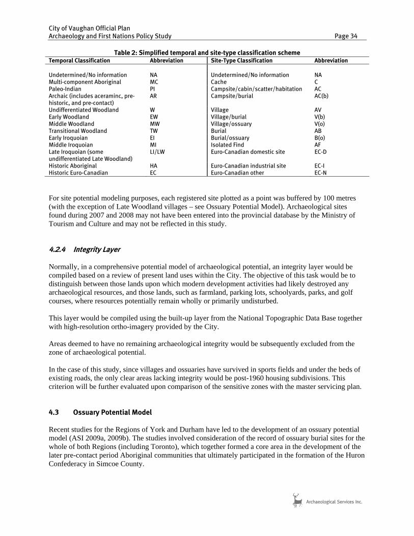
City of Vaughan Official Plan Archaeology and First Nations Policy Study Page 34
For site potential modeling purposes, each registered site plotted as a point was buffered by 100 metres (with the exception of Late Woodland villages – see Ossuary Potential Model). Archaeological sites found during 2007 and 2008 may not have been entered into the provincial database by the Ministry of Tourism and Culture and may not be reflected in this study. 4.2.4 Integrity Layer Normally, in a comprehensive potential model of archaeological potential, an integrity layer would be compiled based on a review of present land uses within the City. The objective of this task would be to distinguish between those lands upon which modern development activities had likely destroyed any archaeological resources, and those lands, such as farmland, parking lots, schoolyards, parks, and golf courses, where resources potentially remain wholly or primarily undisturbed. This layer would be compiled using the built-up layer from the National Topographic Data Base together with high-resolution ortho-imagery provided by the City. Areas deemed to have no remaining archaeological integrity would be subsequently excluded from the zone of archaeological potential. In the case of this study, since villages and ossuaries have survived in sports fields and under the beds of existing roads, the only clear areas lacking integrity would be post-1960 housing subdivisions. This criterion will be further evaluated upon comparison of the sensitive zones with the master servicing plan. 4.3 Ossuary Potential Model Recent studies for the Regions of York and Durham have led to the development of an ossuary potential model (ASI 2009a, 2009b). The studies involved consideration of the record of ossuary burial sites for the whole of both Regions (including Toronto), which together formed a core area in the development of the later pre-contact period Aboriginal communities that ultimately participated in the formation of the Huron Confederacy in Simcoe County.
Table 2: Simplified temporal and site-type classification scheme Temporal Classification Abbreviation Site-Type Classification Abbreviation
Undetermined/No information NA Undetermined/No information NA Multi-component Aboriginal MC Cache C Paleo-Indian PI Campsite/cabin/scatter/habitation AC Archaic (includes aceraminc, pre-historic, and pre-contact)
AR Campsite/burial AC(b)
Undifferentiated Woodland W Village AV Early Woodland EW Village/burial V(b) Middle Woodland MW Village/ossuary V(o) Transitional Woodland TW Burial AB Early Iroquoian EI Burial/ossuary B(o) Middle Iroquoian MI Isolated Find AF Late Iroquoian (some undifferentiated Late Woodland)
LI/LW Euro-Canadian domestic site EC-D
Historic Aboriginal HA Euro-Canadian industrial site EC-I Historic Euro-Canadian EC Euro-Canadian other EC-N
City of Vaughan Official Plan Archaeology and First Nations Policy Study Page 35
The density of Late Woodland villages in the City of Vaughan (Figure 4) strongly suggests that a number more as yet undetected and associated ossuaries will be present within these areas. Predicting the potential locations of such features is a challenging task, as the locations for such sites were likely chosen primarily for ideological or aesthetic reasons that are not amenable to the economically based methods of spatial analysis utilized in standard archaeological site potential models. Such places held particular significance in terms of their spiritual, historical and social associations, particularly in view of the complexity of Iroquoian views of death and the afterlife as attested by the documented views of the seventeenth-century Huron. The multiplicity of souls comprising the individual, and their various powers for good and ill, required careful management and propitiation. Huron villages were inhabited by the free souls of both the living and the recently dead who had not yet been sent on their way by means of the Feast of the Dead. Moreover, living villages were also surrounded by villages of the dead, as deserted settlements remained inhabited by the souls of those ancestors who, for one reason or another, were unable to make the journey to the Land of the Dead (Trigger 1969:103-104). These spirits remained in the abandoned villages and planted their own crops in the former clearings (von Gernet 1994:42-45; cf. Hall 1976:363). Within such a worldview, ossuaries, and the transformative activities that took place at them, were likely essential to the continued well being of the community both in life and in death (Robertson 2004). Given this importance, it is likely that the places chosen for such features were only decided upon after much deliberation. There is no way of controlling for these variables, which were ultimately rooted in the complex symbolic traditions and ideological worldview of these communities. Any attempt to reconstruct the decision-making process that led to the establishment of ossuaries in the places that they are found today can only be expected to be at the most coarse of scales. Ossuaries are essentially invisible in the modern landscape. Their detection during Stage 2 archaeological assessment is virtually impossible. Most of the ossuaries known to archaeologists were first discovered as a result of land clearance in the nineteenth century. The locations of those sites may or may not be well-documented. Moreover, it is difficult to predict the location of such features in more than a general manner. This is partially a reflection of the available data, although the data that do exist have not been rigorously examined by archaeologists in either the academic or cultural resource management context. Modern discoveries of ossuaries are generally accidental results of large scale earth-moving or other construction activities, as most recently occurred in the Moatfield soccer field in Toronto (Williamson and Pfeiffer [eds] 2003) or during the widening of Teston Road in the City of Vaughan (ASI 2005b). In an effort to redress this situation, the studies constituted a review of the available data concerning documented ossuary locations in the York and Durham regions in an effort to identify potential locational trends for ossuaries relative to settlement sites and local landscape features. Few such insights were forthcoming. Nevertheless, on the basis of this research, several recommendations concerning appropriate burial management strategies during development were offered. It should also be noted that even though ossuary burial was a major rite in southern Ontario during the Late Woodland, burials may also occur in other locations, such as on settlement sites (either within or between houses, or on the margins of the settlement compound), or even in “isolated” locations that are apparently unrelated to any other site. There is a presumption, for example, that Late Woodland period villages, in particular, exhibit a heightened potential for human burials. The occurrence of such interments on settlement sites can rarely be predicted in advance of their actual discovery through excavation, unless previous investigations of the site have resulted in the recovery of human bone and/or a suite of diagnostic/unusual artifacts.
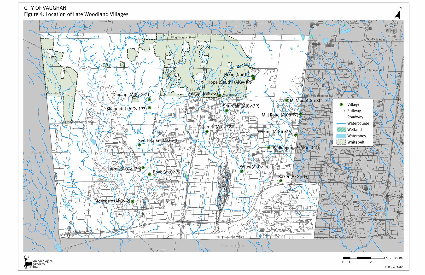
[¿
[¿
[¿
[¿
[¿
[¿
[¿
[¿
[¿
[¿[¿
[¿
[¿
[¿[¿
[¿[¿
Y o r k
P e e l
T o r o n t o
Boyd (AkGv-3)Baker (AkGu-15)
McNair (AlGu-8)
Keffer (AkGv-14)
Senang (AlGu-314)Jarrett (AlGv-18)
McKenzie (AkGv-2)
Latree (AkGv-139)
Damiani (AlGv-231)
ShurGain (AlGv-39)
Mill Road (AlGu-77)
Seed-Barker (AkGv-1)
Skandatut (AlGv-193)
Hope (South) (AlGv-199)
Hope (North)
Walkington 2 (AlGu-341)
Teston (AlGv-2)
[¿ Village
Railway
Roadway
Watercourse
Wetland
Waterbody
¯
0 1 2 30.5Kilometres
Whitebelt
ArchaeologicalServicesInc.
CITY OF VAUGHANFigure 4: Location of Late Woodland Villages
FEB 25, 2009
Highway 7
Jane
Stre
et
Hig
hway
27
Keel
e St
reet
Hig
hway
400
Wes
ton
Roa
d
Highway 407
Bath
urst
Stre
et
Rutherford Road
Highw
ay 50
Steeles Avenue West
Islington Avenue
16th Avenue
Steeles Avenue East
19th Avenue
Nashville Road
Stouffville Road
Pine
Val
ley
Driv
e
Woo
dbin
e Av
enue
Hig
hway
427
Centre Street
Elgin Mills Road West
Major Mackenzie Drive West
Teston Road
Yong
e St
reet
Pine
Val
ley
Driv
e
Highway 407
Hig
hway
404
Langstaff Road
King Vaughan Road
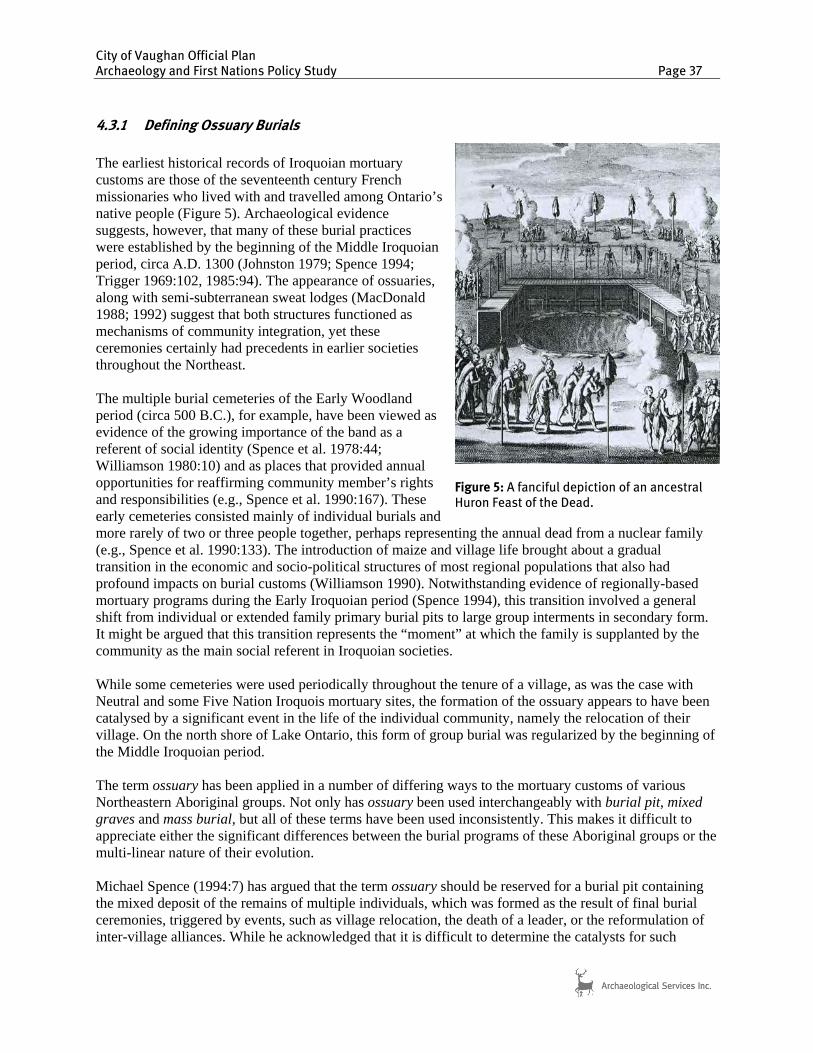
City of Vaughan Official Plan Archaeology and First Nations Policy Study Page 37
4.3.1 Defining Ossuary Burials
The earliest historical records of Iroquoian mortuary customs are those of the seventeenth century French missionaries who lived with and travelled among Ontario’s native people (Figure 5). Archaeological evidence suggests, however, that many of these burial practices were established by the beginning of the Middle Iroquoian period, circa A.D. 1300 (Johnston 1979; Spence 1994; Trigger 1969:102, 1985:94). The appearance of ossuaries, along with semi-subterranean sweat lodges (MacDonald 1988; 1992) suggest that both structures functioned as mechanisms of community integration, yet these ceremonies certainly had precedents in earlier societies throughout the Northeast. The multiple burial cemeteries of the Early Woodland period (circa 500 B.C.), for example, have been viewed as evidence of the growing importance of the band as a referent of social identity (Spence et al. 1978:44; Williamson 1980:10) and as places that provided annual opportunities for reaffirming community member’s rights and responsibilities (e.g., Spence et al. 1990:167). These early cemeteries consisted mainly of individual burials and more rarely of two or three people together, perhaps representing the annual dead from a nuclear family (e.g., Spence et al. 1990:133). The introduction of maize and village life brought about a gradual transition in the economic and socio-political structures of most regional populations that also had profound impacts on burial customs (Williamson 1990). Notwithstanding evidence of regionally-based mortuary programs during the Early Iroquoian period (Spence 1994), this transition involved a general shift from individual or extended family primary burial pits to large group interments in secondary form. It might be argued that this transition represents the “moment” at which the family is supplanted by the community as the main social referent in Iroquoian societies. While some cemeteries were used periodically throughout the tenure of a village, as was the case with Neutral and some Five Nation Iroquois mortuary sites, the formation of the ossuary appears to have been catalysed by a significant event in the life of the individual community, namely the relocation of their village. On the north shore of Lake Ontario, this form of group burial was regularized by the beginning of the Middle Iroquoian period. The term ossuary has been applied in a number of differing ways to the mortuary customs of various Northeastern Aboriginal groups. Not only has ossuary been used interchangeably with burial pit, mixed graves and mass burial, but all of these terms have been used inconsistently. This makes it difficult to appreciate either the significant differences between the burial programs of these Aboriginal groups or the multi-linear nature of their evolution. Michael Spence (1994:7) has argued that the term ossuary should be reserved for a burial pit containing the mixed deposit of the remains of multiple individuals, which was formed as the result of final burial ceremonies, triggered by events, such as village relocation, the death of a leader, or the reformulation of inter-village alliances. While he acknowledged that it is difficult to determine the catalysts for such
Figure 5: A fanciful depiction of an ancestral Huron Feast of the Dead.

City of Vaughan Official Plan Archaeology and First Nations Policy Study Page 38
events, he was attempting to distinguish between special and infrequent ceremonies and features containing multiple secondary burials formed during regular burial episodes in community cemeteries. He argued that ossuary burial would result in the interment of more individuals and fewer articulations (or less evidence of dismemberment), since much more time would have passed between the death of at least some individuals and their reburial, thereby allowing for the complete decomposition of soft tissue in the primary burial context. Spence also hypothesized that at least in Early Iroquoian times, there may have been a transitional stage between primary and ossuary burial, which involved the periodic exhumation of primary burials and their re-interment in common pits. These in turn would be exhumed later for final “ossuary” burial, perhaps at the time of village relocation. While secondary burial pits containing the fragmentary remains of several individuals might constitute evidence of such a practice, it is equally possible that pits containing the remains, partial or complete, of several individuals might represent the final group burial of an extended family or even a clan segment. In such situations, a full understanding of the feature’s archaeological context (e.g., proximity to a community cemetery) as well as detailed observations of each burial would be required in order to discern the differences between transitional forms of ossuary burial and contributing features to periodic reburial ceremonies at a community cemetery (Spence 1994:8). Richard Johnston (1979) also differentiated between the Huron ossuary and other burial traditions. He argued that a late period Huron ossuary was not simply a grave containing the remains of several individuals, which was otherwise common in the Northeast, but a large bone deposit consisting of numerous incomplete and disarticulated interments. He went on to define an ossuary as the common burial of the secondary remains of a minimum of 10 or 12 individuals, as a result of the concerted action by a social group larger than an extended family or limited kin group and when the numbers of individuals represented are in the hundreds, on the part of several neighbouring villages. Marian White (1966:15-22) also defined multiple burial classes for the historic period in the Niagara Frontier of southern Ontario and New York State, prompted by her analysis of the partially mixed secondary deposit of some three or four hundred individuals from the Orchid ossuary in Fort Erie, Ontario. She distinguished between ossuary forms with and without single burials, mixed graves containing multiple bundles and single primary burials and cemeteries, which contained primary interments, usually of single individuals. White, like Spence, also called for careful delineation of burial features to differentiate between disarticulated and incomplete secondary burials from primary burials that have had most elements removed for ossuary burial (e.g., Esler 1998:161; Ramsden et al. 1998:82-83). Mary Jackes (1996:128) also provided a detailed definition for the term ossuary. She argued that an ossuary is “a multiple burial in which most individuals are interred after natural or artificial disarticulation” and that, while bones may be arranged by skeletal element, they are rarely retained in bundles containing recognizable individuals. Jackes suggested an arbitrary figure of 25% as the maximum number of individuals that should be recognizable within an ossuary. This contrasts with what Jackes refers to as a burial pit or a feature containing the bones of many individuals within which the majority retain articulations or are at least recognizable as individuals, e.g., bundle burials (Jackes 1996:130). According to this scheme, the former would apply to most Huron or ancestral Huron burial deposits while the latter would apply to Neutral or ancestral Neutral cemeteries. In summary, therefore, an ossuary represents a burial event whereby the secondary remains of multiple individuals were re-interred in a generally mixed deposit. It is assumed that such features were normally formed during a single ceremonial event, triggered by occurrences such as village relocation, the death of a leader, or the reformulation of inter-village alliances. Village relocations, for instance, are thought to have occurred every eight to 12 years among the Huron of Simcoe County, as local resources became
City of Vaughan Official Plan Archaeology and First Nations Policy Study Page 39
increasingly degraded or scarce (Tooker 1964; Trigger 1969; Heidenreich 1971). Among the pre-contact Iroquoians of southern Ontario, however, such settlement shifts are thought to have been less frequent, occurring approximately every fifteen to thirty years (e.g., Warrick 1990). The rate of village relocation, a factor directly related to both the local environmental setting and population densities, and arguably the most predictable variable, may have significant implications for the number of ossuary sites that may be expected to exist within a given region. The remains that were incorporated within the ossuary had, for the most part originally been interred elsewhere and were exhumed for inclusion in the ossuary feature. Therefore, the majority of the bones in the ossuary are disarticulated. As noted above, it was the Middle Iroquoian period that saw the development of community-wide ossuaries in south-central Ontario. This represents the crystallization of the basic patterns that characterized contact-era Huron practices, and a shift away from the use of the smaller common burial pits that appear on many earlier village sites (e.g., Kenyon 1968; Warrick 1991). On the basis of present evidence, the earliest true ossuaries appear to be the three eleventh to fourteenth century features at Serpent Mounds on Rice Lake, which combined, contained the remains of 69 individuals (Johnston 1979:92-93, 97) and the late thirteenth-early fourteenth century Moatfield ossuary, which contained at least 87 people (Williamson and Pfeiffer [eds] 2003). These sites, in their different ways, foreshadow the developments of the Middle Iroquoian period in south-central Ontario. The Huron Feast of the Dead represents the culmination of this historical development. It seems reasonable to conclude, therefore, that other basic aspects of the Huron mortuary program were taking shape at the same time, if they were not already in place. The Huron funerary process in Simcoe County is well documented in the writings of the seventeenth explorers and missionaries. Gabriel Sagard noted that the village cemetery was usually located “an harquebus-shot” from its village (Wrong 1939:75), which Heidenreich (1971:149) suggests was a distance of 250 to 350 metres. Upon the death of an individual, and after three days of mourning, he or she was typically interred in the cemetery in the manner described by Samuel de Champlain:
they take the body of the deceased, wrap it in furs, cover it very neatly with tree-bark, then lift it up on four posts on which they build a cabin covered with tree-bark, as long as the body. Others they put into the ground, which is propped up on all sides for fear lest it fall on the body, which they cover with tree-bark, putting earth on top, and over this grave likewise they erect a little cabin. Now it must be understood that these bodies are thus buried in these places only for a time…[Biggar 1922-1936: 160-161].
Sagard further recorded that the burial huts or shrines over graves might be surrounded by “a hedge of stakes…out of honour for the dead and to protect the burial house from dogs and wild animals” (Wrong 1939:208). Death and burial were occasions for feasting, and public lamentation and bereaved spouses were expected to continue to follow a prescribed code of mourning behaviour for some time in order to demonstrate their grief over their loss. Women, in particular, would visit the cemetery frequently to mourn at the graves and memorial feasts were held on a regular basis (Thwaites 1896-1901:10:269-275). Like ossuaries, large primary, but temporary, cemeteries in direct association with villages as described in the seventeenth century French accounts do not seem to be regular visible features of the archaeological record of south-central Ontario. The only published examples seem to be those noted for the early sixteenth century Mackenzie-Woodbridge and Keffer villages, to which may be added the recently excavated Mantle site.

City of Vaughan Official Plan Archaeology and First Nations Policy Study Page 40
The Mackenzie-Woodbridge site was situated on the northern reaches of the Humber River in Toronto, and originally assumed to have been a “pre-contact Huron” community (Wright 1966:69). While a looted ossuary is reported to have been found less than a kilometre from the site (Wright 1966:70), more than a dozen individuals were found in a cemetery situated on a sandy knoll about 100 metres from the site (Saunders 1986). As all ages and both sexes were recovered, in both primary inhumation and secondary bundled forms, Saunders (1986:24) suggested a burial tradition more similar to Neutral practice than to Huron. While the potential presence of Neutral influence on Humber River communities has long been noted (e.g., Ramsden 1977:281-282), it is perhaps best to consider that influence in the context of tribal polities involved in far-reaching exchange systems in a number of directions (Robertson and Williamson 1998:146-150). Without data on the reported ossuary, there is no way to reach a resolution regarding the burial tradition that the site occupants followed. The “cemetery” associated with the Keffer site, located on the West Don River, is less compelling. In this instance, the primary cemetery has only been characterized as “two burials outside the palisade…[an unspecified] number of pits that may have held burials…[and] an arrangement of six large post moulds that may have been a scaffold” (Finlayson et al. 1987:14). While the details are vague, this description does not convey the impression that the cemetery could have fully served the needs of the village, whose population has been estimated to have exceeded 700 people (Finlayson et al. 1987:20). The recently excavated Mantle site, a large, early sixteenth century village located on Stouffville Creek, also had an associated cemetery. The excavations revealed a four hectare settlement containing over 90 house structures, at least 50 of which were occupied at one time, all encircled by a multiple-rowed palisade. The artifacts recovered from the settlement include a significant number of artifacts, mainly in the form of modelled human effigies on ceramic vessels, that are more usually found on contemporaneous Oneida villages in New York State (Williamson and Clish 2006).The cemetery, which consisted of 37 primary interments, was found within 100 metres of the village defences on a terrace of the adjacent creek valley. While Mantle was primarily an ancestral Huron community, the cemetery pattern more closely resembles Neutral or New York Iroquois practices (or perhaps Anishnaubeg) and may thus reflect the rites of only a small, distinct segment within the settlement. Given the scale of village site excavation within the past two decades, it would appear that while one or two individual burials might be found on the periphery of the village, large primary cemeteries were not located immediately adjacent to the settlement compound, but at a greater distance, as the historical sources on the Huron suggest. If this is indeed the case, then these cemeteries are likely to remain largely invisible unless they happened to include an occupational component, as has been documented at the fourteenth-century Hutchinson site, which is located on a tributary of the Rouge River in Scarborough (Robertson 2004). Even there, however, the Iroquoian component was only recognized incidentally during a re-examination of a Euro-Canadian farmstead. Returning to the seventeenth century French accounts of the Huron, it is clear that not all who died were buried in the cemetery. Infants, for example, were excluded from formal cemetery burial. Instead they were buried along paths frequented by their mothers, so their souls would re-enter the womb and be reborn in the next child (Thwaites 1896-1901:10:273). The souls of victims of violent death were believed to be dangerous and were accorded exclusive funeral treatment, in that their bodies were burned or buried immediately, the implication being that in some cases this occurred almost literally “where they fell” (Thwaites 1896-1901:39:31). Individuals who died on a journey were cremated and their bones were collected (Thwaites 1896-1901:10:129), presumably to be returned home and interred as a bundle burial. Others might be taken to the village cemetery, but not interred in formal graves. Victims of drowning or freezing were taken to the cemetery, where their bodies were disarticulated, the flesh burned, and the

City of Vaughan Official Plan Archaeology and First Nations Policy Study Page 41
skeletal remains thrown into a ditch, where they apparently remained exposed to the elements (Thwaites 1896-1901:10:273). Generally, all of these unfortunates were excluded from the final ossuary burial. At the end of a particular village’s tenure in a given location, those who had been formally interred in the village cemetery were exhumed for reburial in the ossuary. The accompanying ceremony, the Feast of the Dead, represented the final act prior to village abandonment. The Feast of the Dead lasted several days and involved much ritual feasting, and the exchange of gifts, serving to socially integrate both the living and the dead more than any other event (Trigger 1969:102-112). In his Relation of 1636, Jean de Brébeuf provided a brief description of some of the preliminaries to the Feast of the Dead and the events which culminated in the creation of the ossuary:
Twelve years or thereabout having elapsed, the Old Men and Notables of the Country assemble, to deliberate in a definite way on the time at which the feast shall be held to the satisfaction of the whole Country and of the foreign Nations that may be invited to it. The decision having been made, as all the bodies are to be transported to the Village where is the common grave, each family sees to its dead, but with a care and affection that cannot be described; if they have dead relatives in any part of the Country, they spare no trouble to go for them; they take them from the Cemeteries, bear them on their shoulders, and cover them with the finest robes they have. In each Village they choose a fair day, and proceed to the Cemetery, where those called Aiheonde, who take care of the graves, draw the bodies from the tombs in the presence of the relatives.… …after having opened the graves, they display before you all these Corpses.… The flesh of some is quite gone, and there is only parchment on their bones; in other cases the bodies look as if they have been dried and smoked, and show scarcely any signs of putrefaction; and in still other cases they are still swarming with worms. When the friends have gazed upon the bodies to their satisfaction, they cover them with handsome Beaver robes quite new: finally, after some time, they strip them of their flesh, taking of skin and flesh which they throw into the fire along with the robes and mats in which the bodies were wrapped. As regards the bodies of those recently dead, they leave these in the state in which they are, and content themselves by simply covering them with new robes. …The bones having been well cleaned, they put them partly into bags, partly into fur robes, loaded them on their shoulders, and covered these packages with another beautiful hanging robe. As for the whole bodies, they put them on a species of litter, and carried them with all the others, each to his Cabin, where each family made a feast to its dead. …A day or two before setting out for the feast, they carried all these souls [i.e., bones] into one of the largest Cabins of the Village, where one portion was hung to the poles of the Cabin, and the other portion spread out through it; the Captain entertained them, and made them a magnificent feast. …The seven or eight days before the [final Feast of the Dead ceremony] were spent in assembling the souls, as well as the Strangers who had been invited; meanwhile from morning until night the living were continually making presents to the youth, in consideration of the dead. …On setting out from the Village, the whole band cried out haéé, haé, and repeated this cry of the souls by the way. This cry they say relieves them greatly; otherwise the burden, although of souls, would weigh very heavily on their backs, and cause them a backache all the rest of their lives. They go short journeys; our Village was three days in going four leagues to reach Ossossané, which we call la Rochelle, where the ceremonies were to take place. As soon as they arrive near a Village they cry again haéé, haé. The whole Village comes to meet them; plenty of gifts are given on such an occasion. Each has his rendezvous in one of the Cabins, all know where they are to
City of Vaughan Official Plan Archaeology and First Nations Policy Study Page 42
lodge their souls, so it is done without confusion. At the same time, the Captains hold a Council, to discuss how long the band shall sojourn in the Village …All the souls of eight or nine Villages had reached la Rochelle by the Saturday of Pentecost; but the fear of bad weather compelled them, as I have said, to postpone the ceremony until Monday. We were lodged a quarter of a league away, at the old Village, in a Cabin where there were fully a hundred souls hung to and fixed upon the poles, some of -which smelled a little stronger than musk. …On Monday, about noon, they came to inform us that we should hold ourselves in readiness, for they were going to begin the ceremony; they took down at the same time, the packages of souls; and the relatives again unfolded them to say their last adieus; the tears flowed afresh…. The one who bore the body of this old Captain walked at the head; the men followed, and then the women, walking in this order until they reached the pit. …Let me describe the arrangement of this place. It was about the size of the place Royale at Paris. There was in the middle of it a great pit, about ten feet deep and five brasses wide. All around it was a scaffold, a sort of staging very well made, nine to ten brasses in width, and from nine to ten feet high; above this staging there were a number of poles laid across, and well arranged, with cross-poles to which these packages of souls were hung and bound. The whole bodies, as they were to be put in the bottom of the pit, had been the preceding day placed under the scaffold, stretched upon bark or mats fastened to stakes about the height of a man, on the borders of the pit. The whole Company arrived with their corpses about an hour after Midday, and divided themselves into different cantons, according to their families and Villages, and laid on the ground their parcels of souls, almost as they do earthen pots at the Village Fairs. They unfolded also their parcels of robes, and all the presents they had brought, and hung them upon poles, which were from 5 to 600 toises in extent; so there were as many as twelve hundred presents which remained thus on exhibition two full hours, to give Strangers time to see the wealth and magnificence of the Country.… About three o'clock, each one put away his various articles, and folded up his robes. Meanwhile, each Captain by command gave the signal; and all, at once, loaded with their packages of souls, running as if to the assault of a town, ascended the Stage by means of ladders hung all round it, and hung them to the cross poles, each Village having its own department. That done, all the ladders were taken away; but a few Chiefs remained there and spent the rest of the afternoon, until seven o’clock, in announcing the presents which were made in the name of the dead to certain specified persons. …About five or six o’clock, they lined the bottom and sides of the pit with fine large new robes, each of ten Beaver skins, in such a way that they extended more than a foot out of it. As they were preparing the robes which were to be employed for this purpose, some went down to the bottom and brought up handfuls of sand. I asked what this ceremony meant, and learned that they have a belief that this sand renders them successful at play. Of those twelve hundred presents that had been displayed, forty-eight robes served to line the bottom and sides of the pit; and each, entire body, besides the robe in which it had been enveloped, had another one, and sometimes even two more, to cover it. At seven o’clock, they let down the whole bodies into the pit. On all sides you could have seen them letting down half-decayed bodies… ten or twelve were in the pit and were arranging the bodies all around it, one after another. They put in the very middle of the pit three large kettles, which could only be of use for souls; one had a hole through it, another had no handle, and the third was of scarcely more value.…This is all that was done on this day. All the people passed the night on the spot; they lighted many fires, and slung their kettles.… One of the souls, which was not securely tied, or was perhaps too heavy for the cord that fastened it,
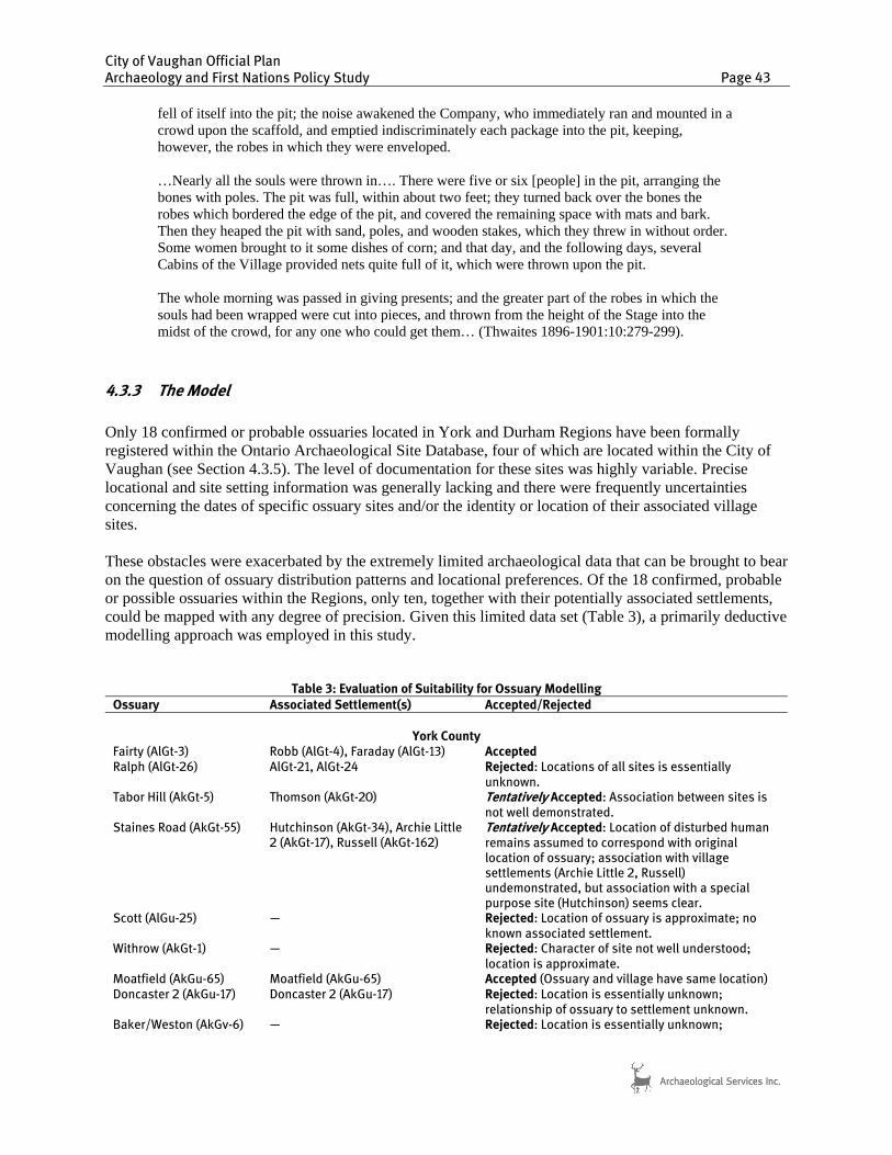
City of Vaughan Official Plan Archaeology and First Nations Policy Study Page 43
fell of itself into the pit; the noise awakened the Company, who immediately ran and mounted in a crowd upon the scaffold, and emptied indiscriminately each package into the pit, keeping, however, the robes in which they were enveloped. …Nearly all the souls were thrown in…. There were five or six [people] in the pit, arranging the bones with poles. The pit was full, within about two feet; they turned back over the bones the robes which bordered the edge of the pit, and covered the remaining space with mats and bark. Then they heaped the pit with sand, poles, and wooden stakes, which they threw in without order. Some women brought to it some dishes of corn; and that day, and the following days, several Cabins of the Village provided nets quite full of it, which were thrown upon the pit. The whole morning was passed in giving presents; and the greater part of the robes in which the souls had been wrapped were cut into pieces, and thrown from the height of the Stage into the midst of the crowd, for any one who could get them… (Thwaites 1896-1901:10:279-299).
4.3.3 The Model
Only 18 confirmed or probable ossuaries located in York and Durham Regions have been formally registered within the Ontario Archaeological Site Database, four of which are located within the City of Vaughan (see Section 4.3.5). The level of documentation for these sites was highly variable. Precise locational and site setting information was generally lacking and there were frequently uncertainties concerning the dates of specific ossuary sites and/or the identity or location of their associated village sites. These obstacles were exacerbated by the extremely limited archaeological data that can be brought to bear on the question of ossuary distribution patterns and locational preferences. Of the 18 confirmed, probable or possible ossuaries within the Regions, only ten, together with their potentially associated settlements, could be mapped with any degree of precision. Given this limited data set (Table 3), a primarily deductive modelling approach was employed in this study.
Table 3: Evaluation of Suitability for Ossuary Modelling
Ossuary Associated Settlement(s) Accepted/Rejected
York County
Fairty (AlGt-3) Robb (AlGt-4), Faraday (AlGt-13) Accepted Ralph (AlGt-26) AlGt-21, AlGt-24 Rejected: Locations of all sites is essentially
unknown. Tabor Hill (AkGt-5) Thomson (AkGt-20) Tentatively Accepted: Association between sites is
not well demonstrated. Staines Road (AkGt-55) Hutchinson (AkGt-34), Archie Little
2 (AkGt-17), Russell (AkGt-162) Tentatively Accepted: Location of disturbed human remains assumed to correspond with original location of ossuary; association with village settlements (Archie Little 2, Russell) undemonstrated, but association with a special purpose site (Hutchinson) seems clear.
Scott (AlGu-25) — Rejected: Location of ossuary is approximate; no known associated settlement.
Withrow (AkGt-1) — Rejected: Character of site not well understood; location is approximate.
Moatfield (AkGu-65) Moatfield (AkGu-65) Accepted (Ossuary and village have same location) Doncaster 2 (AkGu-17) Doncaster 2 (AkGu-17) Rejected: Location is essentially unknown;
relationship of ossuary to settlement unknown. Baker/Weston (AkGv-6) — Rejected: Location is essentially unknown;
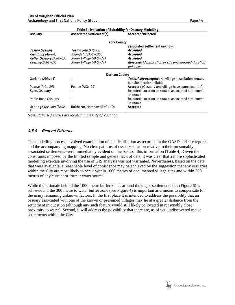
City of Vaughan Official Plan Archaeology and First Nations Policy Study Page 44
Table 3: Evaluation of Suitability for Ossuary Modelling
Ossuary Associated Settlement(s) Accepted/Rejected
York County
associated settlement unknown. Teston Ossuary Teston Site (AlGv-2) Accepted Kleinburg (AlGv-1) Skandatut (AlGv-193) Accepted Keffer Ossuary (AkGv-15) Keffer Village (AkGv-14) Accepted Downey (AkGv-17) Keffer Village (AkGv-14) Rejected: Identification of site unconfirmed; location
unknown
Durham County Garland (AlGs-13) — Tentatively Accepted: No village association known,
but site location reliable. Pearse (AlGs-29) Pearse (AlGs-29) Accepted (Ossuary and village have same location) Syers Ossuary — Rejected: Location unknown; associated settlement
unknown Poole-Rose Ossuary — Rejected: Location unknown; associated settlement
unknown Uxbridge Ossuary (BbGs-3)
Balthazar/Harshaw (BbGs-10) Accepted
Note: Italicised entries are located in the City of Vaughan
4.3.4 General Patterns
The modelling process involved examination of site distribution as recorded in the OASD and site reports and the accompanying mapping. No clear patterns of ossuary location relative to their presumably associated settlements were immediately evident on the basis of this information (Table 4). Given the constraints imposed by the limited sample and general lack of data, it was clear that a more sophisticated modelling exercise involving the use of GIS analysis was not warranted. Nevertheless, based on the data that were available, a reasonable level of confidence may be achieved by the suggestion that any ossuaries within the City are most likely to occur within 1000 metres of documented village sites and within 300 metres of any current or former water source.
While the rationale behind the 1000 metre buffer zones around the major settlement sites (Figure 6) is self-evident, the 300 metre to water buffer zone (see Figure 4) is important as a means to compensate for the many remaining unknown factors. In the first place it is intended to address the possibility that an ossuary associated with one of the known or presumed villages may lie at a greater distance from the settlement in question (although any such feature would still likely be located in reasonably close proximity to water). Second, it will address the possibility that there are, as of yet, undiscovered major settlements within the City.
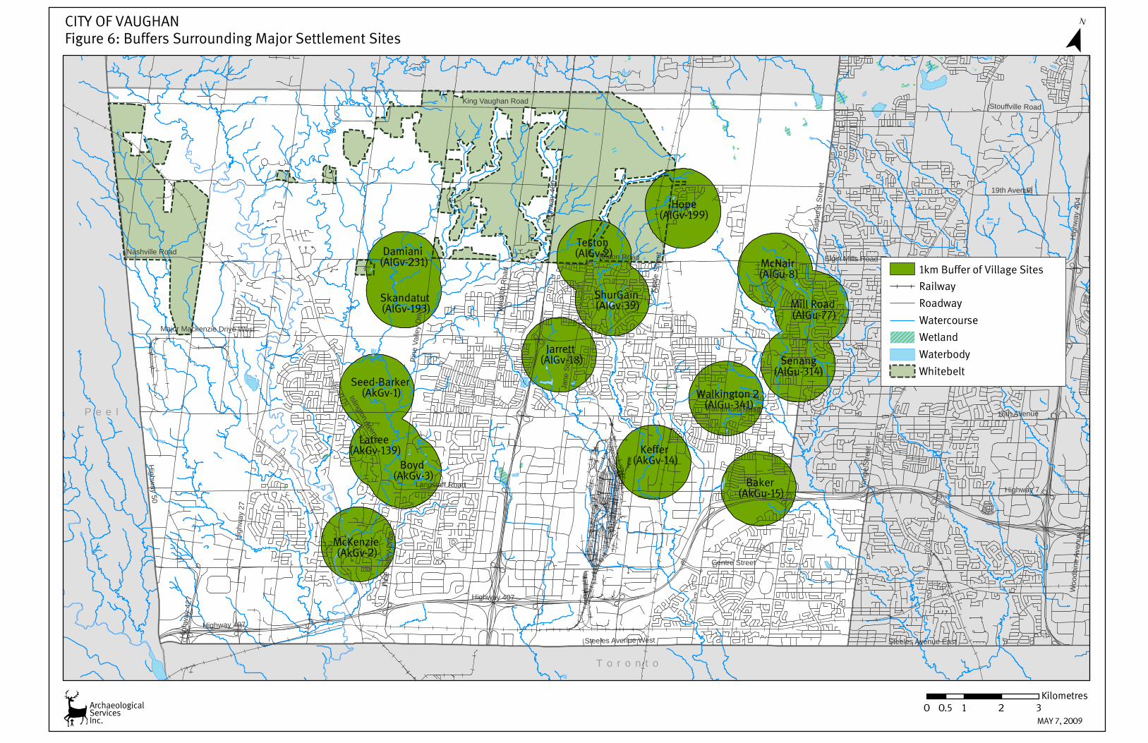
Boyd(AkGv-3)
Baker(AkGu-15)
McNair(AlGu-8)
Keffer(AkGv-14)
Senang(AlGu-314)
Jarrett(AlGv-18)
McKenzie (AkGv-2)
Latree(AkGv-139)
Damiani(AlGv-231)
ShurGain(AlGv-39) Mill Road
(AlGu-77)
Seed-Barker(AkGv-1)
Skandatut(AlGv-193)
Hope(AlGv-199)
Walkington 2 (AlGu-341)
Teston(AlGv-2)
P e e l
T o r o n t o
Highway 7
Jane
Stre
et
Hig
hway
27
Keel
e St
reet
Hig
hway
400
Wes
ton
Roa
d
Highway 407
Bath
urst
Stre
et
Rutherford Road
Highw
ay 50
Steeles Avenue West
Islington Avenue
16th Avenue
Steeles Avenue East
19th Avenue
Nashville Road
Stouffville Road
Pine
Val
ley
Driv
e
Woo
dbin
e Av
enue
Hig
hway
427
Centre Street
Elgin Mills Road
Major Mackenzie Drive West
Teston Road
Yong
e St
reet
Pine
Val
ley
Driv
e
Highway 407
Hig
hway
404
Langstaff Road
King Vaughan Road
1km Buffer of Village Sites
Railway
Roadway
Watercourse
Wetland
Waterbody
¯
0 1 2 30.5Kilometres
Whitebelt
ArchaeologicalServicesInc.
CITY OF VAUGHANFigure 6: Buffers Surrounding Major Settlement Sites
MAY 7, 2009
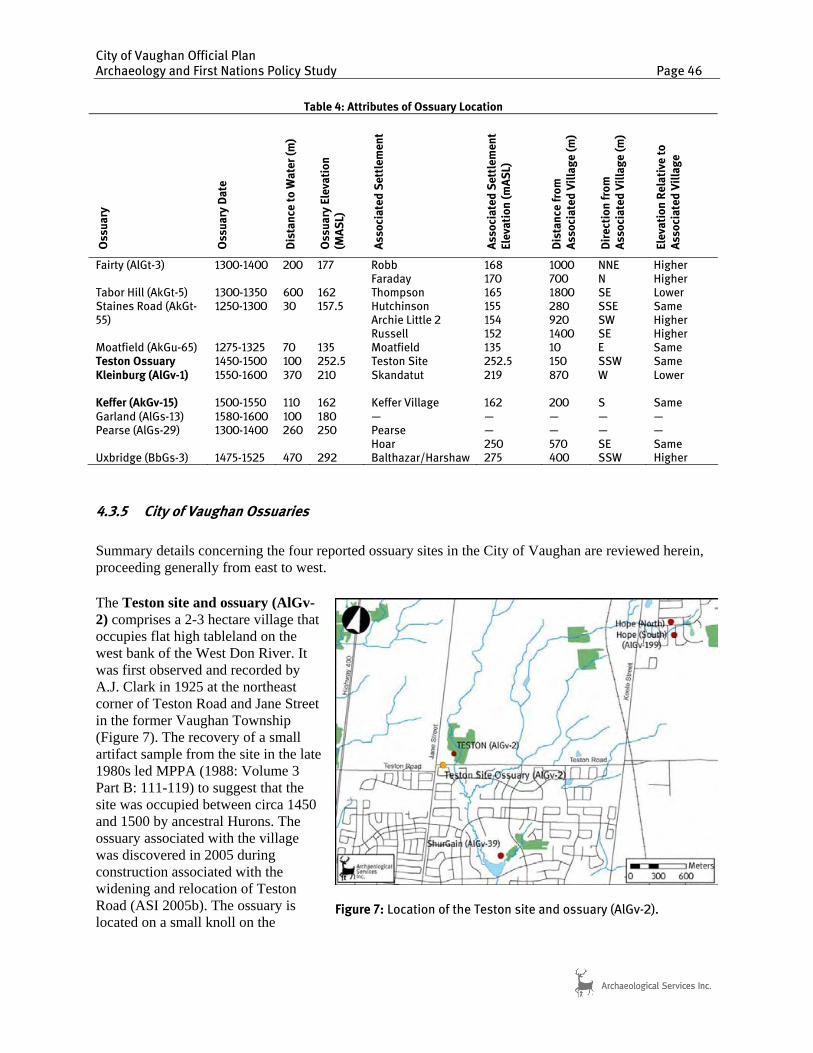
City of Vaughan Official Plan Archaeology and First Nations Policy Study Page 46
4.3.5 City of Vaughan Ossuaries
Summary details concerning the four reported ossuary sites in the City of Vaughan are reviewed herein, proceeding generally from east to west. The Teston site and ossuary (AlGv-2) comprises a 2-3 hectare village that occupies flat high tableland on the west bank of the West Don River. It was first observed and recorded by A.J. Clark in 1925 at the northeast corner of Teston Road and Jane Street in the former Vaughan Township (Figure 7). The recovery of a small artifact sample from the site in the late 1980s led MPPA (1988: Volume 3 Part B: 111-119) to suggest that the site was occupied between circa 1450 and 1500 by ancestral Hurons. The ossuary associated with the village was discovered in 2005 during construction associated with the widening and relocation of Teston Road (ASI 2005b). The ossuary is located on a small knoll on the
Table 4: Attributes of Ossuary Location O
ssu
ary
Oss
ua
ry D
ate
Dis
tan
ce t
o W
ate
r (m
)
Oss
ua
ry E
leva
tio
n
(MA
SL)
Ass
oci
ate
d S
ett
lem
en
t
Ass
oci
ate
d S
ett
lem
en
t E
leva
tio
n (
mA
SL)
Dis
tan
ce f
rom
A
sso
cia
ted
Vil
lag
e (
m)
Dir
ect
ion
fro
m
Ass
oci
ate
d V
illa
ge
(m
)
Ele
vati
on
Re
lati
ve t
o
Ass
oci
ate
d V
illa
ge
Fairty (AlGt-3) 1300-1400 200 177 Robb Faraday
168 170
1000 700
NNE N
Higher Higher
Tabor Hill (AkGt-5) 1300-1350 600 162 Thompson 165 1800 SE Lower Staines Road (AkGt-55)
1250-1300 30 157.5 Hutchinson Archie Little 2 Russell
155 154 152
280 920 1400
SSE SW SE
Same Higher Higher
Moatfield (AkGu-65) 1275-1325 70 135 Moatfield 135 10 E Same Teston Ossuary 1450-1500 100 252.5 Teston Site 252.5 150 SSW Same Kleinburg (AlGv-1) 1550-1600 370 210 Skandatut
219
870
W
Lower
Keffer (AkGv-15) 1500-1550 110 162 Keffer Village 162 200 S Same Garland (AlGs-13) 1580-1600 100 180 — — — — — Pearse (AlGs-29) 1300-1400 260 250 Pearse
Hoar — 250
— 570
— SE
— Same
Uxbridge (BbGs-3) 1475-1525 470 292 Balthazar/Harshaw 275 400 SSW Higher
Figure 7: Location of the Teston site and ossuary (AlGv-2).

City of Vaughan Official Plan Archaeology and First Nations Policy Study Page 47
tablelands, in the order of one to two hundred metres to the southwest of the village (the precise limits of which are not known). Located in the flats between branches of the East Humber River (Figure 8), the Kleinburg ossuary (AlGv-1) was excavated in 1970 under the supervision of Dean Knight and Jerry Melbye. According to Pfeiffer and Fairgrieve (1994:51), the pit contained the remains of 561 individuals. Four peripheral burials were also found including one extended, one flexed, one bundle, and one partial individual. Grave goods interred with the deposit include bone and ceramic objects, early style iron trade axes, an iron kettle, shell beads, native copper beads, and large glass trade beads. Recently, an early contact period ancestral Huron village was discovered approximately 600 metres east of the Kleinburg ossuary (ASI 2004b). The Skandatut site (AlGv-193) is located on a high, steep-sided promontory overlooking the Humber valley and the location of the ossuary. Skandatut’s primary external ties, appear to be oriented towards the Neutral of the Hamilton-Niagara region, given the predominance of plain collarless vessels, which occur in large numbers on contact period sites in that area. The Keffer ossuary (AkGv-15) is located to the northeast of the confluence of two tributaries of the West Don River in the City of Vaughan (Figure 9). The site was first reported by David Boyle in 1889, who noted that the feature had been dug into on two previous occasions. Boyle and Roland Orr also excavated into the feature and commented on the exceedingly intractable nature of the clay soil and its poor drainage (Boyle 1889:20; 1907:16). Orr removed 50 crania from the burial pit, which was described as being 12 feet in diameter. The site was later capped by the construction of a large barn. This structure was demolished in 1987, resulting in the rediscovery of the ossuary. The feature was not investigated further at that time, and it
Figure 8: Location of the Kleinburg Ossuary (AlGv-1).
Figure 9: Location of the Keffer Ossuary (AkGv-15) and the Downey Ossuary (AkGv-17).

City of Vaughan Official Plan Archaeology and First Nations Policy Study Page 48
is believed that it has been protected. The Keffer ossuary is located approximately 150-200 metres south of the former location of the early to mid-sixteenth century ancestral Huron Keffer village site (AkGv-14), which at its maximum size, likely supported a population of 800-1000 people (Finlayson et al. 1985). Another ossuary, registered as Downey (AkGv-17) has been reported in relation to the Keffer site (Figure 9). It was first documented in 1925 by A.J. Clark, on the basis of a somewhat vague second-hand account of a discovery of human remains “many years earlier” (DRPA 2000:11). Several attempts to reconstruct the location of the site over the past 20 years have been unsuccessful (cf. MPA 1989; DRPA 2000; ASI 2005c). Moreover, it should be noted that Clark did not see the feature first hand, nor is there any indication as to the number of individuals represented by the remains that were reportedly exhumed. Rather he assumed that the remains that were uncovered were derived from a Late Woodland period ossuary, most likely associated with the Keffer site, although the ossuary (AkGv-15) that was presumably associated with that village had been long known. The Keffer site was located approximately 600 metres southeast of the estimated location of the Downey ossuary. A single village associated with two disparate ossuary sites is not an occurrence that has previously been documented in the archaeological record of southern Ontario (cf. Williamson and Steiss 2003). Therefore, while it is possible that the Downey site represented an ossuary associated with some other nearby but undocumented Late Woodland settlement, it is equally possible that the remains that were reported were interred as one or more isolated burials during the Late Woodland or some earlier period entirely.
4.4 Composite Archaeological Potential Layer
The final GIS layer, which is the map of the composite zone of archaeological potential within the City of Vaughan was compiled by merging the zones of pre-contact archaeological potential, historic archaeological potential, and buffers around historic and pre-contact sites (100 m for all sites with the exception of Late Woodland villages, which are buffered by 1000 m) (Table 5). The resultant potential mapping presents an approximation of the overall distribution of archaeological resources in the City and a more precise estimate of potential ossuary locations (Figure 10).
Table 5: Summary of Site Potential Modelling Criteria
Environmental or Cultural Feature Buffer Distance (metres) Buffer Qualifier
Pre-contact Aboriginal Site Potential
Lake Ontario 300 none two-line rivers 300 none wetlands 200 >0.5 ha.; well and imperfectly drained soils
only valley lands (top of bank) 200 none single-line watercourses 200 well and imperfectly drained soils only Pre-contact sites (pre-Iroquoian) 100 Iroquoian villages 1000
Historic Archaeological Site Potential historic settlement centres polygon as mapped no buffer designated sites 100 none historic features 100 as illustrated on historic maps early settlement roads 200 both sides early railways 50 both sides cemeteries 100 m around polygons none historic archaeological sites 100 none

Maple
Woodbridge
Thornhill
Kleinburg
Nashville
Pine Grove
Edgeley
Humber
Vellore
Brownsville
PattersonColeraine
Elder Mills
Concord
Purpleville
Teston
Carrville
Tormore
Y o r k
P e e l
T o r o n t o
¯
0 2 4 61Kilometers
ArchaeologicalServicesInc.
CITY OF VAUGHANFigure 10: Composite Archaeological Potential Layer
July 30th, 2009
Composite Archaeological Potential
City of Vaughan
Waterbody
Wetland
Watercourse
Railway
Roadway
Legend
Historic Settlement Centres
City of Vaughan Official Plan Archaeology and First Nations Policy Study Page 50
5.0 JURISDICTION OVER ARCHAEOLOGICAL RESOURCES In terms of direct conservation and protection, the lead provincial government role has been filled by the Minister of Culture. The Minister is responsible for encouraging the sharing of cultural heritage and for determining policies, priorities and programs for the conservation, protection and preservation of the heritage of Ontario (Cuming 1985). Under the Ontario Heritage Act, a process is defined that ensures that “once a property is designated of archaeological or historical significance and is likely to be adversely affected by commercial, industrial, agricultural, residential, or other development,” the appropriate measures are taken. In order to maintain a professional standard of archaeological research and consultation, the Minister is responsible for issuing licenses to qualified individuals, without which archaeological activities involving exploration, survey or field work are illegal. All reports submitted to the Ministry, as a condition of an archaeological license are reviewed by Ministry staff to ensure that the activities conducted under a license meet current technical guidelines, resource conservation standards, and the regulations of the Ontario Heritage Act. The regulation of archaeological activities carried out within the development context requires that all approval authorities must integrate the requirements of the Ontario Heritage Act within their land use planning process. The rationale for a greater sharing of responsibilities between provincial and local governments for all types of heritage including archaeological resources was explained most effectively in a document entitled A Strategy for Conserving Ontario’s Heritage (Ontario Heritage Policy Review 1990). This document suggested a re-allocation of roles, in which the provincial government would maintain an advisory function and the municipal governments would assume the day-to-day responsibility for monitoring those archaeological features in their jurisdiction. 5.1 Provincial Legislation The specific provincial legislation governing planning decisions is complex, but provides for a number of opportunities for the integration of archaeological conservation. The two principal pieces of legislation are the Planning Act (2005) and the Environmental Assessment Act (1997). Despite the on-going provincial transfer of review responsibilities, well over 1000 formal development applications throughout the province, under both Environmental Assessment and Planning Act processes, are reviewed annually by the Ministry of Tourism and Culture. Consequently, approximately 500 to 800 archaeological sites have been documented annually in southern Ontario since 1990 as a result of planning mechanisms. 5.1.1 The Ontario Planning Act (2005) and the Provincial Policy Statement (2005) With respect to archaeological resources, the most recent Provincial Policy Statement, which came into effect March 1, 2005, states that:
Development and site alteration shall only be permitted on lands containing archaeological resources or areas of archaeological potential if the significant archaeological resources have been conserved by removal4 and documentation, or by preservation on site. Where significant archaeological resources must be preserved on site, only development and site alteration which maintain the heritage integrity of the site will be permitted (Section 2.6, Cultural Heritage and Archaeology).
4 “Removal” of an archaeological resource is accomplished through mitigative documentation and/or excavation.
City of Vaughan Official Plan Archaeology and First Nations Policy Study Page 51
For the above policy statement, significant archaeological resources are defined as those “that are valued for the important contribution they make to our understanding of the history of a place, an event, or a people.” The identification and evaluation of such resources are based upon archaeological fieldwork undertaken in accordance with the Ontario Heritage Act”. Provincial interests in land use planning are also detailed in the Provincial Policy Statement provided in Section 3(1) of the Planning Act, as amended by the Strong Communities Act (2004), whereby:
a decision of the council of a municipality, a local board, a planning board, a minister of the Crown and a ministry, board, commission or agency of the government, including the Municipal Board, in respect of the exercise of any authority that affects a planning matter, “shall be consistent” with this policy statement.
Thus all decisions made during the development process, regardless of the identity of the development proponent or the relevant approval agency, must address potential heritage resource impacts. Given the provincial interest, any planning activity referred to in the Planning Act, including the preparation of Official Plans or any planning application, should have regard for matters of provincial interest. The statements in the Act are sufficient for a municipality to require that an archaeological assessment be completed prior to the approval of a planning application.
It should be noted that an archaeological assessment must now be completed and submitted with an application for approval of a plan of subdivision. Section 51 (17) of the Planning Act, Part VI Subdivision of Land, now delineates under Schedule 1 the information and material to be provided by an applicant for approval of a plan of subdivision (O. Reg. 544/06, s. 2). This section states the applicant shall provide the approval authority with the following prescribed information and material:
23. Whether the subject land contains any areas of archaeological potential.
24. If the plan would permit development on land that contains known archaeological resources or areas of archaeological potential,
a) an archaeological assessment prepared by a person who holds a license that is effective with respect to the subject land, issued under Part VI (Conservation of Resources of Archaeological Value) of the Ontario Heritage Act; and
b) a conservation plan for any archaeological resources identified in the assessment. Note that the PPS defines "archaeological resources" as "includes artifacts, archaeological sites and marine archaeological sites" (see Section 1.1 above). In the case of a zoning by-law, the Planning Act allows a municipality to use the option of attaching a holding “H” symbol to a zoning by-law and require that as a condition of removing the holding symbol, and before development can proceed, an archaeological assessment or other matter be completed. Archaeological zoning by-laws may also be developed by a municipality under Section 34 of the Planning Act to protect significant archaeological resources and sites. The municipality must have due regard to matters of provincial interest, which means that archaeological assessments must be undertaken in support of development applications where identified as necessary.
City of Vaughan Official Plan Archaeology and First Nations Policy Study Page 52
In regard to municipal projects, the Planning Act states that where there is an Official Plan in effect, no public work shall be undertaken that does not conform to the Plan. The Act also permits municipalities to pass zoning by-laws: “for prohibiting any use of land and the erecting, locating or using of any class or classes of buildings or structures on land that is the site of a significant archaeological resource”. In summary, a municipality is obligated, within the existing legislative framework, to require archaeological concerns be addressed in connection with any planning application and is able to pass zoning by-law(s) regulating the use of land that is the site of a significant archaeological resource. Moreover, a municipality is prevented from undertaking any public work that does not comply with its Official Plan. Heritage protection policies are appropriate in Official Plans, if developed and incorporated properly. If a municipality has a sound basis in its policies (Official Plan), it is possible to ensure that applications conform to heritage requirements. The Programs and Services Branch of the Ministry of Tourism and Culture has the primary responsibility under the Ontario Planning Act and Ontario Heritage Act for matters relating to cultural heritage including archaeological resources. This branch has developed an “Ontario Heritage Tool Kit” that includes guides for interpreting the Ontario Heritage Act as well as InfoSheets on applying the cultural heritage and archaeology provincial policies. One of their primary responsibilities is to oversee the Municipal Plans Review process. The first component of this process is the determination of the potential for a development application to impact archaeological resources, based on a range of environmental and historic criteria. Should it be determined that there is potential for impacts to archaeological resources resulting from the approval of the development application, then the second component is the requirement that the development proponent undertake an archaeological assessment, the results of which are subject to Ministry of Tourism and Culture review and acceptance. Such assessments may be required for official plan amendments or plans of subdivision, and may also be required for smaller-scale developments reviewed under consent and zoning by-law amendment applications. In all of those cases where potential is identified on all or a portion of a subject property, a standard archaeological condition is attached to the development application. The current condition recommended by the Ministry of Tourism and Culture reads:
The proponent shall carry out an archaeological assessment of the subject property and mitigate, through preservation or resource removal and documentation, adverse impacts to any significant archaeological resources found. No grading or other soil disturbances shall take place on the subject property prior to the City of Vaughan and the Ministry of Tourism and Culture confirming that all archaeological resource concerns have met licensing and resource conservation requirements.
While a generic primer has been developed by the Ministry of Culture (1997) for informing municipal planners about evaluating archaeological potential, those municipalities that have undertaken detailed archaeological potential studies or master plans have access to much more detailed information, that provides more effective and accurate means of determining archaeological potential and whether or not an assessment will be required. The review of site specific development applications, for the purpose of determining if archaeological resources or areas of archaeological potential are present within any particular subject plan, may now be made directly by the City of Vaughan through the use of this archaeological master plan, consisting of potential mapping, explanatory text, and suggested procedures for implementation of the study’s conclusions. Review of the resulting archaeological investigations, in order to determine that Ontario Heritage Act requirements have been satisfied, remains the responsibility

City of Vaughan Official Plan Archaeology and First Nations Policy Study Page 53
of the Ministry of Tourism and Culture, which provides notification to the consulting archaeologist of the results of their review. The Ministry of Tourism and Culture may notify the approval authority and development proponent of their review. That Ministry also administers all matters related to the management of the resources documented, mitigation strategies proposed, and any disputes arising from the conservation of archaeological resources under the land use planning process. 5.1.2 The Ontario Environmental Assessment Act (1997) The Environmental Assessment Act (1997) applies to public sector projects and designated private sector projects. Private sector projects that are designated by the Province as subject to the Act are usually major projects such as landfills. The purpose of the Act is “the betterment of the people ... by providing for the protection, conservation and wise management in Ontario of the environment” (Section 2). Environment is very broadly defined to include “the social, economic and cultural conditions that influence the life of man or a community” [Section 1(c) (iii)] and “any building, structure ... made by man” [Section 1(c) (iv)]. Thus, environment is broadly interpreted to include heritage artifacts, structures or events. The Environmental Assessment Act requires the preparation of an environmental assessment document, containing inventories, alternatives, evaluations and mitigation. It is subject to formal government review and public scrutiny and, potentially, to a tribunal hearing. Heritage studies of these major undertakings are a common component. There are also Municipal Engineers Association (MEA) Class environmental assessments for municipal projects that require similar considerations, but entail a simplified review and approval process. Various provincial ministries are establishing protocols related to activities subject to the environmental assessment process, in order to ensure that heritage concerns in their respective jurisdictions are addressed. The Ontario Ministry of Transportation (2004), for example, ensures that archaeological surveys are undertaken in advance of all new road construction in order to ensure that no archaeological sites will be unknowingly damaged or destroyed, and the Ontario Ministry of Natural Resources prepared a set of guidelines on the conservation of heritage features as part of the Timber Management Planning Process (1991). 5.1.3 The Ontario Heritage Act The Ontario Heritage Act (Ontario Regulation 170/04) defines “archaeological site” as “any property that contains an artifact or any other physical evidence of past human use or activity that is of cultural heritage value or interest”; “artifact” as “any object, material or substance that is made, modified, used, deposited or affected by human action and is of cultural heritage value or interest”. As such, archaeological sites are both highly fragile and non-renewable. The Ministry of Tourism and Culture5 is charged under Section 2 of the Ontario Heritage Act with the responsibility to “determine policies, priorities and programs for the conservation, protection and preservation of the heritage of Ontario” and so fills the lead provincial government role in terms of direct conservation and protection of cultural resources. The Minister is responsible for encouraging the sharing of cultural heritage and for determining policies, priorities and programs for the conservation, protection
5 Provincial management of cultural resources has been carried out by operations units attached variously to the Ministry of Citizenship, Culture and Recreation (1993-1998), the Ministry of Tourism, Culture and Recreation (1998-2002) and the Ministry of Culture (2002-present).
City of Vaughan Official Plan Archaeology and First Nations Policy Study Page 54
and preservation of the heritage of Ontario (Cuming 1985). These goals are generally accomplished through other legislated processes, such as those required by the Planning Act and Environmental Assessment Act, rather than directly through the Ontario Heritage Act itself. The Ontario Heritage Act does, however, govern the general practice of archaeology in the province. In order to maintain a professional standard of archaeological research and consultation, the Minister is responsible for issuing licenses to qualified individuals. In 2005, changes to the Ontario Heritage Act in Subsection 48(1), made it illegal for any person or agency to knowingly alter an archaeological site without a license (see Section 1.1 for definition of archaeological site). “Alteration” of an archaeological site is deemed to include any form of unsanctioned disturbance or destruction of an archaeological resource brought about by any means (i.e., either archaeological excavation, site looting, or development). This in effect offers automatic protection to all archaeological sites and the City should exercise due diligence in all planning contexts to ensure that archaeological features are protected from disturbance of any nature. Under Subsections 69(1-3) of the Ontario Heritage Act, an individual or a director of a corporation found in violation of the Act or the regulations is liable to a fine of up to $50,000 or imprisonment for up to one year or both. A corporation found in violation of the Act or the regulations is liable to a fine of up to $250,000, and more specifically, if a person or director or officer of a corporation is convicted of knowingly contravening Subsection 48(1), the maximum fine that may be imposed is $1,000,000.00. All reports submitted to the Ministry, as a condition of an archaeological license are reviewed by Ministry staff to ensure that the activities conducted under a license meet current technical guidelines, resource conservation standards, and the regulations of the Ontario Heritage Act. The regulation of archaeological activities carried out within the development context requires that all approval authorities must integrate the requirements of the Ontario Heritage Act within their land use planning process. 5.1.4 Other Provincial Legislation Other land use legislation in the province provides opportunities for archaeological resource protection. The Aggregate Resources Act, governing approval of pits and quarries and administered by the Ministry of Natural Resources, recognizes the potential impact quarrying activities may have on cultural features such as archaeological resources. Furthermore, the development of a pit or quarry will often require an official plan amendment or zoning by-law amendment, and thus would require involvement by the municipality at either the upper or lower tier level. The process for addressing archaeological concerns is similar to that outlined for Planning Act related projects. A background study, field survey and detailed archaeological investigations are all identified as required Technical Reports under Part 2.2 of the Provincial Standards for Bill 53 under the Aggregate Resources Act. The Cemeteries Act also addresses the need to protect human burials, both marked and unmarked, which is yet another valuable link to the past. Burial locations uncovered on archaeological sites constitute “unregistered cemeteries” that are, in essence, in violation of the Cemeteries Act. The discovery of such burials will require further investigation in order to define the extent and number of interments, and either the registration of the burial location as a cemetery, or the removal of the remains for re-interment in an established cemetery. The actual workings of this process are complex and vary depending upon whether the burial(s) are an isolated occurrence, or part of a more formal cemetery, and whether the remains in question are Aboriginal or Euro-Canadian. In all cases, the success of the process is dependent upon the co-operation of the landowner, the next of kin (whether biological or prescribed), and the Cemeteries Registrar (Ministry of Consumer and Business Services). The Ministry of Tourism and Culture’s role in

City of Vaughan Official Plan Archaeology and First Nations Policy Study Page 55
the process is to assist in co-ordinating contact and negotiation between the various parties, and ensuring that archaeological investigations of such burial sites meet provincial standards. Various provincial ministries are establishing protocols related to activities subject to the environmental assessment process, in order to ensure that heritage concerns in their respective jurisdictions are addressed. The Ontario Ministry of Transportation (2004), for example, ensures that archaeological surveys are undertaken in advance of all new road construction in order to ensure that no archaeological sites will be unknowingly damaged or destroyed, and the Ontario Ministry of Natural Resources prepared a set of guidelines on the conservation of heritage features as part of the Timber Management Planning Process (MNR 1991). With this legislative planning context, success in protecting heritage features depends on sufficient resource information, sound policies, the capability to implement requirements, and participation by both local and provincial heritage planners in the process. 5.2 City of Vaughan Official Plan Policies - Existing The City of Vaughan recognizes the conservation of resources of archaeological value as an integral part of an effective and comprehensive heritage conservation program and that there was value in investigating and conserving heritage resources with respect to their contribution to the interpretation of the origins of the community. The City's particular archaeological heritage is founded on pre-contact occupancy by native peoples of lands which are now included within the corporation boundaries, and the age of historic settlement. It was the intent of the Plan to provide for the recognition, investigation and preservation of the City's archaeological resources. To this end, the City undertook an Archaeological Master Plan Study in the late 1980s which was intended to form the basis for detailed archaeological conservation policies and result in the development of policies, guidelines, and a plan of action for the development and protection of archaeological resources and facilities in the City. In the current Official Plan, the City supports the principles of archaeological conservation and that cultural heritage resources should be protected from the adverse effects of development and incompatible land uses and activities. In an attempt to plan for cultural heritage conservation, the City requires that a comprehensive Cultural Heritage Resource Assessment, which includes an archaeological resource assessment, be prepared by a qualified heritage consultant as supporting material for Block Plans. Such assessments may also be required for development applications and for Agricultural Heritage Resource Assessments. In reviewing applications for approval of draft plans of subdivision, Council shall encourage the retention and preservation of any buildings, structures, sites, landscapes, areas, and environments identified as significant in a Cultural Heritage Resource Assessment. 5.2.1 Summary and Draft Official Plan Policies With all of these planning requirements, success in protecting heritage features depends on sufficient resource information, sound policies, the capability to implement requirements, and participation by all City staff in the process. These objectives are also being realized, in the case of archaeological resources, through the inclusion of policies in the Official Plan of the City of Vaughan. Heritage protection policies are appropriate in Official Plans, if developed and incorporated properly, if only to draw attention to the fragility of archaeological sites. Moreover, as the Official Plan is implemented through zoning by-laws regulating building form and planning agreements, it is possible to reinforce provincial, federal and local interests by requiring certain information to be supplied, conditions to be satisfied or actions to be taken.

City of Vaughan Official Plan Archaeology and First Nations Policy Study Page 56
Appendix A presents a draft of these policies. 6.0 ENGAGING ABORIGINAL COMMUNITIES WITH RESPECT TO ARCHAEOLOGICAL RESOURCES A series of recent events related to First Nations concerns with the prevailing development process in southern Ontario, have important implications for the City of Vaughan. Most notable among these are the ongoing controversies over a proposed residential development within the Town of Caledonia and the status of Six Nations claims regarding past treaty processes and land disposition within the Haldimand Tract, as well as the Ipperwash Inquiry. In York and Durham regions, there have also been a number of Environmental Assessment Act related projects that have highlighted the need to engage Aboriginal communities and have resulted in protocols for First Nations consultation. The sources of the tensions that have arisen with regards to potential development impacts on First Nations rights are longstanding and complex and continue to be debated in the Federal and Provincial courts. In 2004, for instance, the Supreme Court of Canada released its decisions in the Haida Nation v. B.C. and Weyerhauser and Taku River Tlingit First Nation v. B.C. cases. These rulings have set out more clearly than ever the scope and extent of the Crown’s duty to consult and, where appropriate, accommodate First Nations prior to development of Crown Lands. These rulings, which are applicable across Canada, noted that third parties, which include local governments, do not owe a duty to consult or accommodate First Nations peoples, as these duties rest solely with the Crown (Federal and Provincial governments). There has not yet been any decision as to whether local governments, as regulators exercising delegated Provincial powers, may also assume any portion of the Province’s duty to consult. This must await future decisions; however, with the current trend towards “downloading” responsibilities from upper levels of government, municipalities will have a duty to enquire whether there has been adequate consultation. Likewise, there is, as yet, no decision concerning municipally-owned or privately-owned lands. Nevertheless, it is clear that local governments should exercise caution in making any decision that could affect a First Nation and should take steps to consult with and fully inform itself of the practices and views of that First Nation. Indeed, in his recent letter of March 2009, the Deputy Premier George Smitherman strongly encouraged municipalities in their Growth Plan conformity work, to engage with Aboriginal communities to ensure they have an opportunity to participate in the process. In the meantime, three relatively recent initiatives have helped to resolve the past problems of inadequate consideration of First Nations concerns with respect to land use planning and may be of direct relevance to future development planning in Vaughan. The first of these was the consultation process developed for the Oak Ridges Moraine/Seaton Class EA. The consultation process was designed to involve the participation of all formal First Nation groups that are—or may potentially be—concerned with that Class EA process. A major positive outcome of the Seaton initiative, despite perceptions that some First Nations had not been consulted adequately, was that it provided an opportunity for the Wendat, Haudenasaunee and the Anishnaubeg Nations to come together and formalize their united interests in their archaeological and cultural heritage. It is often assumed that the First Nation that is geographically closest to a given project is the most suitable group with whom to consult, particularly when the issues at stake are those of archaeological resources and human remains. However, the complex histories of the First Nations of southern Ontario, both before and after European contact and settlement, means that such assumptions can be simplistic and detrimental to the success of the entire consultation process. Often the archaeological sites that are to be
City of Vaughan Official Plan Archaeology and First Nations Policy Study Page 57
the focus of the consultation are of such antiquity that no conclusive identification of cultural affiliation to modern communities is possible. Under circumstances of this sort there should be an effort to identify all groups that are appropriate (on cultural-historical grounds) to act as the designated descendants of those who occupied the project area in the past, and who are willing to participate and ensure that cultural heritage remains are treated in an appropriate and seemly manner. This identification process is best achieved through negotiation with a variety of communities in order that they may themselves arrive at the final decision. In this way, ancient sites are represented by all of the First Nations together. In considering the archaeological resources of the Seaton lands, however, many sites were associated with the Huron-Wendat nation. Indeed, it was established that all confirmed Late Woodland village sites, which were occupied primarily by ancestral Huron, would be protected. This same cooperative approach has been used very effectively most recently in developing a protocol for Aboriginal consultation for the Southeast Collector Trunk Sewer Individual Environmental Assessment by York and Durham regions (project on-going). Secondly, the final draft of the Standards and Guidelines for Consultant Archaeologists developed by the Ministry of Tourism and Culture was released in June 2009. This document includes a draft technical bulletin that requires Aboriginal consultation between Stages 3 and 4 archaeological investigations on Aboriginal sites and recommended consultation before Stage 2 and 3. The new Standards and Guidelines recognize that the Crown has a formal duty to consult with First Nations, where its actions may adversely affect an established or asserted treaty right. They also note that this consultation is separate from any consultation that archaeologists may need to undertake on behalf of their clients in the land development sector (whether municipal or private) with respect to cultural heritage resources. The draft Standards state that “engagement” (meaning consultation) must take place:
• anytime field work uncovers human remains; • whenever a consulting archaeologist intends to propose fieldwork following an
alternate strategy for an archaeological assessment that departs from those laid out in the Standards and Guidelines (this must occur prior to reviewing the proposed strategy with the Ministry itself);
• when assessing the cultural value or interest of an archaeological site that is known or appears to have sacred or spiritual import, or is associated with traditional land uses, geographic features of cultural heritage interest, or Aboriginal oral histories;
• when deciding whether to protect Aboriginal archaeological sites of cultural heritage value or interest (e.g., sites with sacred or spiritual manifestations reflected in the archaeological record, Late Woodland villages, large lithic scatters or quarries, nineteenth century Aboriginal domestic sites, undisturbed sites, any site identified as being of interest on the part of an Aboriginal community).
While these guidelines have not yet been finalized, such consultation is now expected by many First Nations and it will be important that the City of Vaughan ensure that such consultation has occurred in their jurisdiction. Access to archaeological information was one of the catalysts responsible for escalating the Caledonia dispute. Finally, in the fall of 2006, the Ministry of Municipal Affairs and Housing initiated a project to begin training its staff on Aboriginal heritage issues and to develop an approach to engage First Nations/Aboriginal groups on future land use planning initiatives. Further outreach to the Ministry’s

City of Vaughan Official Plan Archaeology and First Nations Policy Study Page 58
municipal clients and the development industry on the intersection of Aboriginal affairs and land use planning are also foreseen.
7.0 IMPLEMENTATION
7.1 Introduction As discussed above, the role of municipalities in the conservation of heritage features is crucial. Planning and land use control are predominantly municipal government responsibilities and the impact of municipal land use decisions on archaeological resources is significant, especially since municipally-approved developments constitute the majority of land disturbing activities in the Province (Hansen 1984). Without adequate screening at a municipal level, the provincial government is unable to ensure protection for valued archaeological resources. Viewed from this perspective, archaeological protection cannot be implemented without municipal involvement. The primary means by which cultural heritage resources are best protected is through the planning process. This requires the development of appropriate policies for the City of Vaughan and incorporation into the review process. The municipality also plays a crucial role in ensuring that the archaeological site protection measures of the Ontario Heritage Act are recognized and valued. The mapping prepared for this study is designed to be used by City of Vaughan staff to make decisions regarding requirements for archaeological resource assessments and/or monitoring in advance of development and/or site alteration. Education is an important part of this process. While the public is generally supportive of environmental causes, we must also educate our community that the record of our cultural environment is slowly vanishing. As a science, archaeology often suffers from the attitudes and actions which result from public misconceptions about its motives, aims and methods. It is encouraging to note that when members of the public are made aware of archaeological sites, there exists a genuine interest not only in the pre-contact history and history of a City, but also in archaeology itself as an academic discipline. The City should support programs and endeavours related to involving the public in the investigation of the City’s archaeological record. 7.2 Recommended Archaeological Resource Management Procedures The archaeological review procedure, as it relates to development, requires close co-operation between the Policy Planning and Urban Design Department, the Recreation and Culture Department, and other City of Vaughan Departments, the staff of the Programs and Services Branch (Culture Programs Unit) of Ministry of Tourism and Culture, as well as both the development and the archaeological/historical research communities. In the case of all land-use alterations, the determination of whether or not there is a need for archaeological assessment will form part of the pre-consultation process between the development proponent and the City prior to the submission of an application. This will be determined by evaluating whether the application (or any part of it) is situated within the zone of archaeological potential. This archaeological procedure should also apply to municipal development and/or infrastructure projects that involve construction, erection or placing of a building or structure. In addition, other activities such as site grading, excavation, removal of topsoil, or peat and the placing and dumping of fill; drainage works, except for the maintenance of existing municipal and agricultural drains, should be subject to the same procedures.

City of Vaughan Official Plan Archaeology and First Nations Policy Study Page 59
In order to apply the archaeological procedure on all public lands managed by the City, the Policy Planning and Urban Design and Recreation and Culture Departments should hold internal discussions with staff from other departments to establish protocols that ensure that in all appropriate circumstances, construction projects undertaken by those departments that are located in areas of archaeological potential or areas identified as being archaeologically sensitive, are subject to archaeological assessment prior to any land disturbing activity. Through such discussions, the Policy Planning and Urban Design and Recreation and Culture Departments will be better able to establish some guidelines on the kind of work that needs to be reviewed for possible archaeological concerns and work which would not require review. 7.3 The Planning Review Process: A Summary Recommended guidelines for the approach used in the review process for all land disturbance applications within the City are summarized below. As part of the pre-consultation process, City staff will determine if an archaeological assessment is required for a proposed application by means of review of the archaeological potential mapping. Should any portion of the property fall within a zone of archaeological potential or should the property contain a previously registered archaeological site, the City will require that the applicant undertake an archaeological assessment as a supportive document for planning application. The development applicant will then retain a licensed archaeologist to conduct a Stage 1 or Stage 1-2 archaeological assessment of the entire subject property, not simply the portion(s) that falls within the zone of archaeological potential. All work conducted by the licensed archaeologist must conform to the standards set forth in the most current (draft or approved) Archaeological Assessment Technical Guidelines authorized by the Ministry of Tourism and Culture. In the case of rural severances, only the land disturbance footprint need be assessed unless that footprint exceeds 50% of the area of the created lot. In the case that the footprint of land disturbance exceeds 50% of the lot area, the entire lot upon which construction is proposed will be assessed. Once the archaeological assessment, consisting of background research and field survey (if required), has been completed, the archaeological consultant must submit a report to the Programs and Services Branch of Ministry of Tourism and Culture and to the Policy Planning and Urban Design and Recreation and Culture Departments. The Ministry of Tourism and Culture should be requested to provide a copy to the City on any compliance letter issued to an archaeological consultant. This letter will serve to notify both parties that all provincial concerns with respect to archaeological resource conservation and archaeological licensing have been met. Upon receipt of this notification of Ministry of Tourism and Culture acceptance and supporting documentation (e.g., copies of archaeological site registration forms and reports) from the archaeological consultant, the City may then clear the planning application of any further archaeological concern. The following wording for a standard archaeological condition should be used in planning agreements, where the need for an archaeological assessment has been identified.

City of Vaughan Official Plan Archaeology and First Nations Policy Study Page 60
In cases where there is no identified archaeological potential, the following standard clauses (amended from time to time) must be included, as required by the Ministry of Tourism and Culture:
(a) Should archaeological resources be found on the property during construction activities, all work must cease and both the Ontario Ministry of Tourism and Culture and the City of Vaughan’s Policy Planning and Urban Design and Recreation and Culture Departments shall be notified immediately.
(b) In the event that human remains are encountered during construction activities, the
proponent must immediately cease all construction activities. The proponent shall contact the City of Vaughan’s Police Department, the Regional Coroner and the Registrar of the Cemeteries Regulation Unit of the Ministry of Consumer and Business Services.
These clauses will also be included in every Stage 1-2 archaeological assessment report. The following information should also be provided to applicants concerning the archaeological assessment process.
THE ASSESSMENT PROCESS A Stage 1 assessment consists of background research concerning registered sites on the subject lands or within close proximity, as well as the environmental character of the property and its land use history. A Stage 2 assessment consists of field survey to document any sites that may be present on a property. It should be noted that completion of an archaeological field assessment of a particular development property, no matter how rigorous, does not fully guarantee that all significant archaeological resources on that property will be identified prior to land disturbance. This is particularly the case in areas where
WORDING FOR THE ARCHAEOLOGICAL CONDITION The proponent shall carry out an archaeological assessment of the entire development property and mitigate, through preservation or resource removal and documentation, adverse impacts to any significant archaeological resources found. No demolition, grading or other soil disturbances shall take place on the subject property prior to the approval authority confirming that all archaeological resource concerns have met resource conservation requirements. The property will be assessed by a consultant archaeologist, licensed by the Ministry of Tourism and Culture under the provisions of the Ontario Heritage Act (R.S.O. 1990); and any significant sites found will be properly mitigated (avoided or excavated), prior to the initiation of construction, servicing, landscaping or other land disturbances. The consultant archaeologist will submit 1) 1:10,000 scale mapping that clearly outlines the limits of the property subject to assessment and the locations of any new archaeological site locations; and 2) a copy of the relevant assessment report(s) all to the Cultural Services Department.

City of Vaughan Official Plan Archaeology and First Nations Policy Study Page 61
processes such as filling, flooding or erosion have resulted in the burial of original ground surfaces, or with respect to isolated human burials that are typically small features that can escape detection. Stage 3 investigations are designed to secure a detailed understanding of the nature and extent of a site and may involve complete or partial systematic surface collection and test excavation. Stage 4 undertakings comprise extensive excavation; comparative analysis and interpretation of content and contextual information. If one or more significant archaeological sites that will require further mitigation are documented during the course of an assessment, it is generally possible to secure partial clearance for the property, in that the archaeological requirement may be removed from the balance of the subject lands not encompassed by the archaeological site(s) and suitable protective buffer zones. Although the final report of comprehensive archaeological mitigation work may take many months to complete, final clearance for the property may be available upon the archaeological consultant completing the fieldwork, submitting a brief executive summary to Ministry of Tourism and Culture staff and the proponent providing information regarding any outstanding concerns (e.g., commitment to production of the final report). Should a proponent choose not to proceed with all necessary assessment and/or site mitigations prior to, and in support of the application, the completion of these activities to the satisfaction of Ministry of Tourism and Culture and the Cultural Services Department must be made a condition of draft approval. 7.4 The Municipal Project Review Process For municipal projects, whether or not they are subject to the Environmental Assessment Act, the same process will be followed. Should the project impact areas of archaeological potential, the completion of an assessment and any necessary mitigation, subject to the approval of Ministry of Tourism and Culture, will be required. 7.5 Assessing Resource Impacts and Identifying Mitigation Strategies If no adverse impacts to an archaeological resource will occur, then development may proceed as planned. Should a significant archaeological resource be discovered during the course of an assessment, the development proponent, a representative of a relevant and appropriate First Nation (in the case of precontact sites), the archaeological consultant, Ministry of Tourism and Culture, and the approval authority must assess the potential impact to an archaeological resource and arrive at rational decisions regarding integration of that resource into the site or development plan or the implementation of mitigative options. The review process at this stage requires the input of the proponent in order to make the decisions regarding potential adverse effects to a site. Should a site be threatened, the two available options are to immediately integrate the site into the development plan such as through re-allocation of open space/community park space or provide for mitigative procedures. The decision-making process with respect to mitigative procedures may be subject, however, to a cost benefit analysis where the mitigative option involves input from all of the stakeholders (i.e., the First Nation, the City, Ministry of Tourism and Culture, the heritage community and the development proponent - either public sector or private sector).

City of Vaughan Official Plan Archaeology and First Nations Policy Study Page 62
It is often assumed that the First Nation that is geographically closest to the project is the most suitable group with whom to consult, particularly when the issues at stake are those of archaeological resources and human remains. However, the complex histories of the First Nations of southern Ontario, both before and after European contact and settlement, means that such assumptions can be simplistic and detrimental to the success of the entire consultation process. Under all circumstances there should be an effort to identify the group or more likely groups that are the most appropriate (on cultural-historical grounds) to act as the designated descendants of those who occupied the project area in the past, and who are willing to participate and ensure that cultural heritage remains are treated in an appropriate and seemly manner. This identification process is best achieved through negotiation with a variety of communities in order that they may themselves arrive at the final decision. It should also be noted that the Ministry of Tourism and Culture has issued new draft Standards and Guidelines for Archaeological Assessment, which includes a requirement for Aboriginal Engagement between Stages 3 and 4 archaeological investigations on Aboriginal sites and recommended consultation before Stage 2 and 3. While these guidelines have not yet been finalized, such consultation is now expected by most First Nations. In any situation, there are a number of mitigative options, including avoidance, modifications to construction techniques, and various degrees of documentation and/or excavation, as discussed below. Similarly, in all cases, thought should be given to the interpretive and educational potential of the site. Detailed information regarding a site is frequently required in order to make a more accurate assessment of significance and to determine the potential for adverse effects. This may involve different levels of on-site investigations. Many of the sites routinely encountered will prove to be of little or no significance and will not require further investigation, beyond the mapping, measuring and photographing of the surface attributes of the archaeological site that has already occurred during the course of the initial archaeological assessment. Where more extensive archaeological mitigation is required, recommended mitigative options may take numerous forms, including:
Preservation: the preferred mitigative option. Preservation may involve long-term protective measures such as project design changes (site avoidance) that integrate the resource within the overall development plan. To further avoid both accidental impact and intentional vandalism and looting, additional protective measures may include fencing, screening, or capping (only in special circumstances). The City must determine whether preservation is to occur on the landscape scale (i.e., areas of high cultural landscape heritage integrity combined with high archaeological potential are to be preserved as a whole), or at the scale of individual sites that are deemed to be particularly significant or sensitive (e.g., Late Woodland settlements that may contain human burials).
Stabilization: may be required in the case of eroding archaeological deposits. This may involve
the salvage excavation of the eroding area and/or the construction of retaining walls or barriers. Systematic Data Recovery: involves the recovery of data from significant archaeological sites,
when other mitigative options are not feasible. It includes a complete or partial systematic surface collection, excavation, or both; a comparative analysis and interpretation of content and contextual information; and production of an investigative report. This mitigation strategy ultimately results in the destruction of the archaeological site.

City of Vaughan Official Plan Archaeology and First Nations Policy Study Page 63
Monitoring: monitoring may be undertaken (only in specific circumstances) to ensure that adverse impacts on archaeological sites which could not be predicted or evaluated prior to construction are addressed. Monitoring requires the presence of a licensed archaeologist during the construction phase of a project. This takes the form of scheduled site visits and on-call availability during a long term project.
All decisions regarding mitigative options or preservation strategies are subject to Ministry of Tourism and Culture review and approval. The site preservation/avoidance option has both short- and long-term components. The short-term component involves both the redesign of the development plan (e.g., lot layouts, parkland, road, and service alignments) and ensuring that the resource(s) in question are physically protected during construction by means of fencing or other visible barriers. The long-term protective measures can include the use of zoning by-laws or other conditions or orders for development that prohibit any future land use activities that might result in soil disturbance. For information regarding the preparation of a Conservation Plan, which is a document that details how an archaeological site can be conserved, the proponent and their consultant might consult with InfoSheet #5, Heritage Impact Assessments and Conservation Plans, Ministry of Culture, 2005. Such a plan could only be prepared after a detailed Stage 3 investigation of the site that is necessary to define the nature and extent of the site.
8.0 PLANNING RECOMMENDATIONS
In light of the preceding considerations, the following recommendations are made:
1) That the policies attached as Appendix A be incorporated into the Official Plan.
2) It is recommended that the archaeological potential mapping be used in making requirements for archaeological assessments in advance of development.
3) It is recommended that the Policy Planning and Urban Design and Recreation and Culture
Departments work with City departments to establish protocols that ensure that in all appropriate circumstances, construction projects undertaken by developers, ratepayers and the City of Vaughan that may impact archaeological resources on public lands (e.g., trail, playground, playing field, public washroom, parking lot construction, road widening/extension, trunk sewer and watermain construction, stormwater management facility construction, municipal building and structure construction, etc.) and which are located in areas of archaeological potential, are subject to archaeological assessment prior to any land disturbing activity.
4) All Late Woodland village sites should be removed from developable lands. The boundaries of
such villages must be established through comprehensive Stage 3 mitigations in accordance with the Standards and Guidelines for Consultant Archaeologists (final draft 2009).
5) No Stage 4 archaeological investigations on Aboriginal sites should be undertaken within the City
of Vaughan without first filing a First Nations consultation report with the Policy Planning and Urban Design and Recreation and Culture Departments.
6) Archaeological assessment reports should contain the statement that should deeply buried
archaeological remains be found on a property during construction activities, all work must cease and the Ministry of Tourism and Culture should be notified immediately. It should further specify

City of Vaughan Official Plan Archaeology and First Nations Policy Study Page 64
that if human remains are encountered during construction, the development proponent should immediately cease work, and contact the police or Regional Coroner, and the Registrar of the Cemeteries Regulation Unit of the Ministry of Consumer and Business Services.
If the burials are determined to be of Aboriginal origin, the relevant Aboriginal communities must also be notified and their assistance sought. In any case in which deeply buried archaeological remains (including burials) are encountered, all construction activity in the vicinity of the discovery must be postponed until an appropriate mitigation strategy is identified and executed.
7) In order to ensure the long term viability of the Archaeology and First Nations Policy section of
the City of Vaughan’s Official Plan, it should be subject to comprehensive review on a five year basis by appropriate City of Vaughan staff. Such a review should consider any changes in Ministry of Tourism and Culture criteria for site significance, any data gaps in the site inventory, changes required to the archaeological potential modeling, and all procedures and guidelines related to the implementation of the Plan. Any review regarding site significance should involve a synthesis of archaeological knowledge resulting from the implementation of this plan to define what kind of sites require excavation to further our knowledge of the pre-contact and post-contact past of the City.
8) Archaeological license reports are no longer subject to the Freedom of Information and Protection
of Privacy Act, as well as copyright restrictions, with the exception of sensitive information concerning still extant archaeological site locations. The City may use these reports for internal purposes and provide copies to licensed archaeologists.
9) It is recommended that the City develop and adopt a burial avoidance strategy since the potential
disturbance to ossuaries remains a subject of considerable concern. In order to mitigate this concern it is recommended that predevelopment topsoil removal (grading) within those development area lands that are located within 1000 metres of documented village sites and within 300 metres of any current or former water source should be subject to archaeological monitoring.
The monitoring must be undertaken by a licensed archaeologist. The monitor must be present on a full-time basis during the grading phase for each development project that contains land within the buffers indicated above. A monitor must be dedicated to each project, that is, if a development proponent is undertaking grading work on two or more properties concurrently, an equal number of monitors will be required. The monitor must be equipped with a truck in order to have access to all work areas within the development site and to ensure their safety with respect to the heavy equipment in use on the site. All site supervisors and heavy equipment operators working on site must be briefed in advance concerning the role and responsibilities of the archaeological monitor. Should they encounter potential human remains while the monitor’s attention is elsewhere on site, they must cease work in the area, retain all potentially associated soils in place and notify the monitor and their own supervisors immediately. Should any ossuary feature be discovered during the course of the monitoring work, preservation through avoidance through project redesign/revision should be the ultimate preferred alternative. The details of this form of mitigation must be negotiated with the appropriate First Nation(s) and the Cemeteries Registrar. Indeed, in the event that human remains are encountered during construction, the proponent should immediately contact the Registrar of the Cemeteries

City of Vaughan Official Plan Archaeology and First Nations Policy Study Page 65
Regulation Unit of the Ministry of Consumer and Business Services. Stage 4 salvage excavation of the non-village Late Woodland sites within the City (as determined to be an acceptable option on the basis of the First Nations consultation program) will provide an opportunity to more fully understand their role within the local settlement-subsistence system. There is potential that some of these sites, provisionally identified as “camps” or “cabins”, may have served as specialized burial sites or functioned in support of mortuary activities (as appears to have been the case with the Hutchinson site discussed in Section 4). This can rarely be predicted prior to the onset of the full scale investigations. Upon confirmation that a Late Woodland or Contact period First Nation site served as a cemetery, preservation through avoidance through project redesign/revision should be the ultimate preferred alternative. In any situation in which a human burial is encountered during a Stage 4 salvage excavation, the disposition of the remains (preservation and avoidance versus exhumation and reburial elsewhere) must be negotiated with the appropriate First Nation(s) and the Cemeteries Registrar.
Should any such sites yield evidence that they in some way functioned in support of the local burial/ossuary program, it may be possible to use these findings to arrive at more accurate predictions of ossuary location within the City’s landscape.
10) It is recommended that the City develop and adopt, in consultation with the Ministry of Tourism
and Culture, relevant Aboriginal communities, other agencies, landowners, and the public, a “Contingency Plan for the Protection of Archaeological Resources in Urgent Situations.”
The Contingency Plan should specify that if deeply buried archaeological remains are found on a property during construction activities, work should cease, and then the Ministry of Tourism and Culture and the Cultural Services Department must be notified immediately. It should further specify that if human remains should be encountered during construction, the proponent should immediately cease work, and contact the City of Vaughan Police, the City of Vaughan’s Policy Planning and Urban Design and Recreation and Culture Departments, the Ministry of Tourism and Culture and the Registrar of the Cemeteries Regulation Unit of the Ministry of Consumer and Commercial Relations. As noted above, it is illegal for any person or agency to alter an archaeological site without a license. This in effect offers automatic protection to all archaeological sites and the City must exercise due diligence in all contexts, including emergency situations, to ensure that archaeological features are protected from disturbance of any nature.
Such a Contingency Plan should address: a notification process, involving the City of Vaughan, the Ministry of Tourism and Culture
and any other communities or agencies identified during the consultation process; an investigation and reporting process undertaken by a licensed archaeologist; financial responsibility, structured according to the ability to pay of public sector, private
sector, and individual land owners. In the case of individual land owners, it may be necessary to establish a contingency fund;
the need to establish greater latitude and flexibility in civic financial and other assistance for private conservation activities. Inducements of various types, extended to the private owner/developer in the community interest, are often seen as the quid pro quo for regulatory restrictions (Minister's Advisory Committee 1992:44). While recognizing that the City may be concerned about the potential effects of property tax inducements (e.g., rebates, temporary assessment freezes, etc.) on existing property assessments and tax revenues, it is suggested that the feasibility of such measures merits further consideration during consultation for the Contingency Plan.

City of Vaughan Official Plan Archaeology and First Nations Policy Study Page 66
11) The City of Vaughan should also seek means by which the general public might be made more
knowledgeable of the wide range of archaeological resources present within the City, and of their significance as part of the City's cultural heritage (bearing in mind the necessity that the locations of certain extant sites remain confidential. A heightened public awareness of the importance and fragility of archaeological resources can serve as an additional and effective means of protecting those resources. The City should, therefore, support any programs and endeavours related to involving the public in the investigation of the City’s archaeological record.
9.0 REFERENCES CITED
Ambrose, M.T.
1981 North Pickering Development Corporation Urban Stage One Archaeological Excavation, 1980. Report on file, Ontario Ministry of Culture, Toronto.
ASI (Archaeological Services Inc.) 2004a Stage 3-4 Archaeological Assessment of the Miller (AlGs-1)/Valley Ross Site (AlGs-232),
Concession Road 3 (Rossland Road), Central Duffin Collector Sewage System, Town of Pickering, Regional Municipality of Durham, Ontario, Final Report. Report on file, Ontario Ministry of Culture, Toronto.
2004b Stage 1 and 2 Archaeological Assessment (Revised Report), Block 40/47 Plan, OPA 400, City of Vaughan, Part Lots 22, 23, 24, and 25, Concessions 6 and Part Lots 23, 24, and 25, Concession 7, City of Vaughan, Regional Municipality of York, Ontario. Report on file, Ontario Ministry of Culture, Toronto.
2005a The 1999 Stage 2-4 Assessment of Part of the Jarrett-Lahmer Site (AlGv-18), Lot 17, Concession 5 (WYS), former Township of Vaughan, City of Vaughan, Regional Municipality of York, Ontario, License Report. Report on file, Ministry of Culture, Toronto.
2005b Archaeological Investigation of the Teston Site Ossuary City of Vaughan, Regional Municipality of York, Ontario. Report on file, Cemeteries Registrar, Ontario Ministry of Consumer and Business Services Toronto.
2005c Stage 1 and 2 Archaeological Assessment of 8888 Keele Street, Lot 13, Concession 4, Former Township of Vaughan, County of York, City of Vaughan, Regional Municipality of York. Report on file, Ontario Ministry of Culture, Toronto.
2006 The Stage 4 Salvage Excavation of the Baker Site (AkGu-15), Lot 11, Concession 2 (WYS), Block 10, O.P.A. 400, Former Township of Vaughan, City of Vaughan, Regional Municipality of York, Ontario, License Report. Report on file, Ontario Ministry of Culture, Toronto.
2007 Stage 3 & 4 Archaeological Investigation of the Edgar Site (AlGu-299) Lot 25, Concession 2, Block 12, OPA 400, Former Township of Vaughan, York County, City of Vaughan, Regional Municipality of York. Report on file, Ministry of Culture, Toronto.
2008 Final Stage 3-4 Archaeological Investigation of the Andridge Site (AlGu-347) Draft Plan of Subdivision 19T-99V08 Andridge Homes Limited, Part of Lot 24, Concession 2, Block 12 OPA 400, Geographic Township of Vaughan, County of York, Now the City of Vaughan, Regional Municipality of York, Ontario. Report on file, Ministry of Culture, Toronto.
2009a An Archaeological Site Inventory and Summary Potential Model of Sensitive Aboriginal Sites in the Regional Municipality of York. Report on file, ASI, Toronto.
2009b An Archaeological Site Inventory and Summary Potential Model of Sensitive Aboriginal Sites in the Regional Municipality of Durham. Report on file, ASI, Toronto.
Austin, S.J. 1995 The Toronto Carrying-Place Trail Today. Profile 14(1):1-12. Biggar, H.P. (editor)
1922-1936 The Works of Samuel De Champlain. Volume 3, 1615-1618. Translated by H.H. Langton and W.F. Ganong. Reprinted. University of Toronto Press, Toronto. Originally published 1929, The Champlain Society, Toronto.
Boyle, D.
City of Vaughan Official Plan Archaeology and First Nations Policy Study Page 67
1889 Notes on Sites Visited. Annual Report of the Canadian Institute, Session 1886-87, being part of the Appendix to the Report of the Minister of Education, Toronto. Warwick and Sons, Toronto.
1907 Annual Archaeological Report 1906. Being Part of Appendix to the Report of the Minister of Education, Ontario. L.K. Cameron, Toronto.
Brashler, J., E. Garland, M. Holman, W. Lovis, and S. Martin 2000 Adaptive Strategies and Socioeconomic Systems in Northeast Great Lakes Riverine
Environments: The Late Woodland of Michigan. In Late Woodland Societies: Tradition and Transformation Across the Midcontinent, edited by T. Emerson, D. McElrath, and A. Fortier, pp. 543-579. University of Nebraska Press, Lincoln.
Braun, D.P. 1986 Midwestern Hopewellian Exchange and Supralocal Interaction. In Peer Polity Interaction and
Socio-political Change, edited by A.C. Renfrew and J.F. Cherry, pp. 117-126. Cambridge University Press, Cambridge.
Brumbach, H. J. 1975 Iroquoian Ceramics in “Algonkian” Territory. Man in the Northeast 10:17-28. 1995 Algonquian and Iroquoian Ceramics in the Upper Hudson River Drainage. Northeast
Anthropology 49:55-66. Ceci, L.
1990 Radiocarbon Dating “Village” Sites in Coastal New York: Settlement Pattern Change in the Middle to Late Woodland. Man in the Northeast 39:1-28.
Chapdelaine, C. 1993 The Sedentarization of the Prehistoric Iroquoians: A Slow or Rapid Transformation? Journal of
Anthropological Archaeology 12(2): 173-209. Chapman, L.J. and F. Putnam
1984 The Physiography of Southern Ontario. Ontario Geological Survey, Special Volume 2. Ontario Ministry of Natural Resources, Toronto.
Coleman, Derek J. and Ronald F. Williamson 1994 Landscapes Past to Landscapes Future: Planning for Archaeological Resources. In Great Lakes
Archaeology and Paleoecology: Exploring Interdisciplinary Initiatives for the Nineties, edited by Robert I. MacDonald, pp.61-80. Proceedings of a symposium presented by the Quaternary Science Institute, University of Waterloo, Ontario, September 21-22, 1991.
Cooper, M.S. 1983 Enlarging the Ancestral Estate: A Critique of the Conquest Hypothesis. Antaeus 1: 1-5.
Crawford, G.W., and D.G. Smith 1996 Migration in Prehistory: Princess Point and the Northern Iroquoian Case. American Antiquity
61(4): 782-790. Crawford, G.W., D.G. Smith, and V.E. Boyer
1997 Dating the Entry of Corn (Zea mays) into the Lower Great Lakes Region. American Antiquity 62:112-119.
Cuming, D.J. 1985 Advisory Notes on Heritage Conservation and Municipal Planning. On File at Heritage Branch,
Ministry of Culture and Communications (now Ministry of Culture), Toronto. Daechsel, H., and P.J. Wright
1988 The Sandbanks Tradition – A Late Middle Woodland Manifestation in Eastern Ontario. Paper presented at the 21st Annual Meeting of the Canadian Archaeological Association, Whistler, B.C.
Damkjar, E. 1990 The Coulter Site and Late Iroquoian Coalescence in the Upper Trent Valley. Occasional Papers in
Northeastern Archaeology No. 2, Copetown Press. Dodd, C.F., D.R. Poulton, P.A. Lennox, D.G. Smith, and G.A. Warrick
1990 The Middle Ontario Iroquoian Stage. In The Archaeology of Southern Ontario to A.D. 1650, edited by C.J. Ellis and N. Ferris, pp. 321-360. Occasional Publication 5. London Chapter, Ontario Archaeological Society, London.
DRPA (D.R. Poulton and Associates Inc.) 1998 The 1997 Stage 1-3 Archaeological Assessment of the Lamoreaux and Duffin Heights
Neighbourhoods, Town of Pickering, Regional Municipality of Durham, Ontario. Volumes 1 and 2. Report on file, Ontario Ministry of Culture, Toronto.

City of Vaughan Official Plan Archaeology and First Nations Policy Study Page 68
2000 The 1999 Stage 1-2 Archaeological Assessment of the Proposed Progressive Moulded Products Limited Factory Development, 9000 Keele Street, Site Development Application File #DA.99.087, City of Vaughan, Ontario. Report on file, Ontario Ministry of Culture, Toronto.
Dupras, T.L. and D.G. Pratte 1998 Craniometric Study of the Parsons Crania from Midden 4/Feature 245. Ontario Archaeology,
Special Volume 65/66: 140-145. Ellis, C.J., and D.B. Deller
1990 Paleo-Indians. In The Archaeology of Southern Ontario to A.D. 1650, edited by C.J. Ellis and N. Ferris, pp. 37-64. Occasional Publication 5. London Chapter, Ontario Archaeological Society, London.
Ellis, C.J. and N. Ferris (eds) 1990 The Archaeology of Southern Ontario to A.D. 1650. Occasional Publications 5. London Chapter,
Ontario Archaeological Society, London. Ellis, C.J., I.T. Kenyon, and M.W. Spence
1990 The Archaic. In The Archaeology of Southern Ontario to A.D. 1650, edited by C.J. Ellis and N. Ferris, pp. 65-124. Occasional Publication 5. London Chapter, Ontario Archaeological Society, London.
Emerson, J.N. 1959 A Rejoinder Upon the MacNeish-Emerson Theory. Pennsylvania Archaeologist 29: 98-107.
Engelbrecht, W. 1961 Problems of Huron Origins. Anthropologica III(2):181-201. Engelbrecht, W.E.
1999 Iroquoian Ethnicity and Archaeological Taxa. In Taming the Taxonomy: Toward a New Understanding of Great Lakes Archaeology, edited by R.F. Williamson and C.M. Watts, pp.51-59. Eastendbooks, Toronto.
Esler, J. 1998 Burials and Isolated Human Bone Fragments from Sites in the Crawford Lake Area. In Iroquoian
Peoples of the Land of Rocks and Water, A.D. 1000-1650: A Study in Settlement Archaeology, edited by W.D. Finlayson, Volume 1:156-172. Special Publication 1, London Museum of Archaeology, University of Western Ontario, London.
Feest, J.E., and C.F. Feest 1978 Ottawa. In Handbook of North American Indians, Volume 15 Northeast, edited by Bruce Trigger.,
pp. 772-786. Washington: Smithsonian Institution. Ferris, N.
1999 Telling Tales: Interpretive Trends in Southern Ontario Late Woodland Archaeology. Ontario Archaeology 68:1-62.
Ferris, N., and N.W. Spence 1995 The Woodland Traditions in Southern Ontario. Revista de Archeologia Americana 9: 83-138.
Finlayson, W.D. 1977 The Saugeen Culture: A Middle Woodland Manifestation in Southwestern Ontario. Archaeological
Survey of Canada Mercury Series Paper 61. National Museum of Man, Ottawa. 1985 The 1975 and 1978 Rescue Excavations at the Draper Site: Introduction and Settlement Pattern.
Archaeological Survey of Canada, Mercury Series Paper 130. National Museum of Man, Ottawa. 1998 Iroquoian Peoples of the Land of Rocks and Water, A.D. 1000-1650: A Study in Settlement
Archaeology. London Museum of Archaeology, Special Publication, Vol. 1. London Museum of Archaeology, London, Ontario.
Finlayson, W.D., D.G. Smith, M.W. Spence, and P.A. Timmins 1985 The 1985 Salvage Excavations at the Keffer Site: A Field Report. Report on file, Ministry of
Culture, Toronto. Finlayson, W.D., D.G. Smith, and B. Wheeler
1987 What Columbus Missed! St. George Press and the Museum of Indian Archaeology, University of Western Ontario, Toronto and London.
Fitzgerald, W.R. 1990 Chronology to Culture Process: Lower Great Lakes Archaeology, 1500-1650. Unpublished PhD
Thesis, Department of Anthropology, McGill University, Montreal.

City of Vaughan Official Plan Archaeology and First Nations Policy Study Page 69
Fox, W.A. 1976 The Central North Shore. In The Late Prehistory of the Lake Erie Drainage Basin, edited by D.
Brose, pp. 162-192. Cleveland Museum of Natural History, Cleveland, Ohio. 1990 The Middle to Late Woodland Transition. In The Archaeology of Southern Ontario to A.D. 1650,
edited by C.J. Ellis and N. Ferris, pp. 171-188. Occasional Publication of the London Chapter, Ontario Archaeological Society 5. London, Ontario.
1995 Concluding Remarks. In Origins of the People of the Longhouse: Proceedings of the 21st Annual Symposium of the Ontario Archaeological Society, edited by A. Bekerman and G. Warrick, pp.144-151. Ontario Archaeological Society, North York.
Fox, W.A. and C. Garrad 2004 Hurons in an Algonquian Land. An Archaeological Generation: A Festschrift for Dr. Martha
Latta, Ed. M. Kapches and P. Reed, Ontario Archaeology Special Volume 77/78:121-134. Fox, W.A., R.G.V. Hancock, and L.A. Pavlish
1995 Where East Met West: The New Copper Culture. Wisconsin Archeologist 76:269-293. Freeman, E. B.
1979 Geological Highway Map, Southern Ontario. Ontario Geological Survey, Map 2441. Gramly, R.M.
1977 Deerskins and Hunting Territories: Competition for a Scare Resource of the Northeastern Woodlands. American Antiquity 42(4): 601-605.
Hall, R.L. 1976 Ghosts, Water Barriers, Corn, and Sacred Enclosures in the Eastern Woodlands. American
Antiquity 41:360-364. Hancock, R.G.V., L.A. Pavlish, R.M. Farquar, R. Salloum, W.A. Fox, and G.C. Wilson
1991 Distinguishing European Trade Copper and Northeastern North American Native Copper. Archaeometry 33(1):69-86.
Hansen, G. 1984 Built-on Lands: Definition and Canadian Area Estimates. Plans Canada 17/4.
Hart, J.P. 2001 Maize, Matrilocality, Migration, and Northern Iroquoian Evolution. Journal of Archaeological
Method and Theory 8:151-181. Hart, J.P., R.G. Thompson, and H.J. Brumbach
2003 Phytolith Evidence for Early Maize (Zea Mays) in the Northern Finger Lakes Region of New York. American Antiquity 68:619-640.
Hart, J.P., and R.F. Williamson 2004 The Many Paths to Sedentism: The Contexts of Change in the Northeast. Paper presented at the
69th Annual Meeting of the Society for American Archaeology, Montreal. Heidenreich, C.
1971 Huronia: A History and Geography of the Huron Indians, 1600-1650. McClelland and Stewart, Toronto.
Jackes, M. 1996 Complexity in Seventeenth Century Southern Ontario Burial Practices. In Debating Complexity,
edited by D. A. Meyer, P.C. Dawson and D.T. Hanna, pp 127-140. Proceedings of the 26th Annual Chacmool Conference. Department of Archaeology, University of Calgary, Alberta.
Jackson, L.J. 1983 Early Maize in South-central Ontario. Arch Notes 83(3):9-11.
Jamieson, J.B. 1990 The Archaeology of the St. Lawrence Iroquoians. In The Archaeology of Southern Ontario to A.D.
1650, edited by C.J. Ellis and N. Ferris, pp. 385-404. Occasional Publications of the London Chapter, Ontario Archaeological Society 5. London, Ontario.
Johnston, R.B. 1968 Archaeology of Rice Lake, Ontario. Anthropological Papers 19. National Museum of Canada,
Ottawa. 1979 Notes on Ossuary Burial among the Ontario Iroquois. Canadian Journal of Archaeology 3:91-104.
Jones, S.

City of Vaughan Official Plan Archaeology and First Nations Policy Study Page 70
1997 The Archaeology of Ethnicity: Constructing Identities in the Past and Present. Routledge, New York.
Kapches, M. 1981a The Middleport Pattern in Ontario Iroquoian Prehistory. Unpublished PhD dissertation,
Department of Anthropology, University of Toronto, Toronto. 1981b AlGo-29: The Auda Site. Report submitted to Eldorado Nuclear Limited, Port Hope, Ontario. 1987 The Auda Site: An Early Pickering Iroquois Component in Southeastern Ontario. Archaeology of
Eastern North America 15: 155-175. Katzenberg, M.A., H.P. Schwarcz, M. Knyf, and F.J. Melbye
1995 Stable Isotope Evidence for Maize Horticulture and Paleodiet in Southern Ontario. American Antiquity 60:335-350
Kenyon, W.A. 1968 The Miller Site. Art and Archaeology Occasional Paper 14. Royal Ontario Museum, Toronto.
Kohler, T.A., and S.C. Parker 1986 Predictive Models for Archaeological Resource Location. In Advances in Archaeological Method
and Theory 9, edited by M.B. Schiffer, pp. 397-452. Academic Press, Toronto. Konrad, V.A.
1981 An Iroquois Frontier: The North Shore of Lake Ontario during the Late Seventeenth Century. Journal of Historical Geography 7(2):129-144.
Lennox, P.A., and W.R. Fitzgerald 1990 The Culture History and Archaeology of the Neutral Iroquoians. In The Archaeology of Southern
Ontario to A.D. 1650, edited by C.J. Ellis and N. Ferris, pp. 405-456. Occasional Publication of the London Chapter, Ontario Archaeological Society 5. London, Ontario.
Lytwyn, V.P. 1997 A Dish with One Spoon: The Shared Hunting Grounds Agreement in the Great Lakes and St.
Lawrence Valley Region. In Papers of the 28th Algonquian Conference, edited by D. Pentland, pp. 210-227. University of Manitoba, Winnipeg.
MacDonald, R.I. 1988 Ontario Iroquoian Sweat Lodges. Ontario Archaeology 47:17-26. 1992 Ontario Iroquoian Semi-Subterranean Sweat Lodges. In Ancient Images, Ancient Thought: The
Archaeology of Ideology, edited by A.S. Goldsmith, S. Garvie, D. Selin and J. Smith, pp. 323-330. Proceedings of the 23rd Annual Chacmool Conference. University of Calgary, Calgary.
2002 Late Woodland Settlement in South-central Ontario: A Study of Ecological Relationships and Culture Change. Unpublished PhD dissertation, Department of Anthropology, McGill University, Montreal.
MacDonald, R.I., and R.F. Williamson 1995 The Hibou Site (AlGo-50): Investigating Ontario Iroquoian Origins in the Central North Shore
Area of Lake Ontario. In Origins of the People of the Longhouse, edited by A. Bekerman and G. Warrick, pp. 9-42. Proceedings of the 21st Annual Symposium of the Ontario Archaeological Society Inc., Toronto, Ontario, October 1994.
2001 Sweat Lodges and Solidarity: The Archaeology of the Hubbert Site. Ontario Archaeology 71:29-78.
MacDonald, R.I., and R.H. Pihl 1994 Prehistoric Landscapes and Land Uses: The Role of Predictive Modelling in Cultural Resource
Management. In Great Lakes Archaeology and Paleoecology: Exploring Interdisciplinary Initiatives for the Nineties, edited by R.I. MacDonald, pp. 25-59. Quaternary Sciences Institute Publication No. 10.
MacNeish, R.S. 1952 Ontario Iroquois Pottery Types. National Museum of Canada Bulletin 124. Department of
Resources and Development, Ottawa. MMAH (Ministry of Municipal Affairs and Housing, Ontario) 2004 The Strong Communities (Planning Amendment) Act (Bill 26). 2005 Ontario Planning Act.
2005 Vision for Ontario’s Land Use Planning System. Provincial Policy Statement Part IV, pp. 2-3. Toronto.

City of Vaughan Official Plan Archaeology and First Nations Policy Study Page 71
MNR (Ministry of Natural Resources, Ontario) 1991 Timber Management Guidelines for the Protection of Cultural Heritage Resources. Ontario. MOE (Ministry of the Environment, Ontario) 1997 Environmental Assessment Act. Molto, J.E.
1983 Biological Relationships of Southern Ontario Woodland Peoples: The Evidence of Discontinuous Cranial Morphology. Archaeological Survey of Canada, Mercury Series Paper 117. National Museum of Man, Ottawa.
MOT (Ministry of Transportation, Ontario) 2004 Environmental Protection Requirements for Transportation Planning, and Highway Design,
Construction, Operation and Maintenance. Moreau, J-F., E. Langevin and L.Verrault
1991 An Assessment of the Ceramic Evidence for Woodland-Period Cultures in the Lac Saint-Jean Area, Eastern Quebec. Man in the Northeast 41: 33-64.
MPA (Mayer, Poulton and Associates Inc.) 1989 The Archaeological Facility Master Plan Study of the Town of Vaughan. Four Volumes. Report
on file, City of Vaughan. Nasmith Ramsden, C.
1989 The Kirche Site: A 16th Century Huron Village in the Upper Trent Valley. Occasional Papers in Northeastern Archaeology 1. Copetown Press, Dundas, Ontario.
Niemczycki, M.A.P. 1984 The Origin and Development of the Seneca and Cayuga Tribes of New York State. Rochester
Museum and Science Centre Research Records 17. Rochester Museum and Science Center, Rochester, New York.
Noble, W.C. 1968 Iroquois Archaeology and the Development of Iroquois Social Organization (1000-1650 A.D.): A
Study in Culture Change Based on Archaeology, Ethnohistory and Ethnology. Unpublished PhD dissertation, Department of Archaeology, University of Calgary, Calgary, Alta.
1969 Some Social Implications of the Iroquois “In Situ” Theory. Ontario Archaeology 13:16-28. 1975 Corn and the Development of Village Life in Southern Ontario. Ontario Archaeology 25:37-46.
Noble, W.C., and I.T. Kenyon 1972 Porteus (AgHb-1): A Probable Early Glen Meyer Village in Brant County, Ontario. Ontario
Archaeology 19:11-38. OHPR (Ontario Heritage Policy Review)
1990 A Strategy for Conserving Ontario’s Heritage. Ministry of Culture and Communications (now Ministry of Culture), Toronto.
Pearce, R.J. 1984 Mapping Middleport: A Case Study in Societal Archaeology. Unpublished Ph.D. dissertation,
Department of Anthropology, McGill University, Montreal. Pendergast, J.F.
1993 More on When and Why the St. Lawrence Iroquoians Disappeared. In Essays in St. Lawrence Iroquoian Archaeology, edited by J.F. Pendergast and C. Chapdelaine, pp. 9-48. Occasional Papers in Northeastern Archaeology 8. Copetown Press, Dundas, Ontario.
Pfeiffer, S., and S.I. Fairgrieve 1994 Evidence from Ossuaries: The Effect of Contact on the Health of Iroquoians. In In the Wake of
Contact: Biological Responses to Conquest, edited by G.S. Larsen and G.R. Milner, pp. 47-61. Wiley-Liss, Inc., Toronto.
Pfeiffer, S., and R.F. Williamson 2003 Summary and Conclusions: What We Learned from Studying the Ancestors. In Bones of the
Ancestors: The Archaeology and Osteobiography of the Moatfield Ossuary, edited by R.F. Williamson and S. Pfeiffer, pp. 333-348. Archaeological Survey of Canada Mecury Series Paper 163. Canadian Museum of Civilization, Gatineau, Quebec.
Pihl, Robert H., S. G. Monckton, D. A. Robertson and R.F. Williamson

City of Vaughan Official Plan Archaeology and First Nations Policy Study Page 72
2008 Settlement and Subsistence Change at the Turn of the First Millennium: The View from the Holmedale Site, Brantford, Ontario. In Current Northeast Paleoethnobotany, editec by J.P. Hart, Volume 2:151-172. New York State Museum, Albany.
Popham, R.E., and J.N. Emerson 1952 Comments upon the Huron and Lalonde Occupations of Ontario. American Antiquity 18(2): 197-
210. Ramsden, P.G.
1977 A Refinement of Some Aspects of Huron Ceramic Analysis. Archaeological Survey of Canada, Mercury Series Paper 63. National Museum of Man, Ottawa.
1978 An Hypothesis Concerning the Effects of Early European Trade Among Some Ontario Iroquois. Canadian Journal of Archaeology 2:101.
1990a The Hurons: Archaeology and Culture History. In The Archaeology of Southern Ontario to A.D. 1650, edited by C.J. Ellis and N. Ferris, pp. 361-384. Occasional Publication of the London Chapter, Ontario Archaeological Society 5. London, Ontario.
1990b Saint Lawrence Iroquoians in the Upper Trent River Valley. Man in the Northeast 39:87-95. Ramsden, C.N., R.F. Williamson, R.I. MacDonald, and C. Short
1998 Settlement Patterns. In The Myers Road Site: Archaeology of the Early to Middle Iroquoian Transition, edited by R.F. Williamson, pp. 11-84. Occasional Publication 7. London Chapter, Ontario Archaeological Society, London.
Reid, C.S. 1975 The Boys Site and the Early Ontario Iroquois Tradition. Archaeological Survey of Canada
Mercury Series Paper 42. National Museum of Man, Ottawa Renfrew, A.C.
1986 Introduction: Peer Polity Interaction and Socio-Political Change. In Peer Polity Interaction and Socio-Political Change, edited by A.C. Renfrew and J.F. Cherry, pp. 1-18. Cambridge University Press, Cambridge.
Ridley, F. 1954 The Frank Bay Site, Lake Nipissing, Ontario. American Antiquity 20(1):40-50 1958 Did the Huron Really Migrate North from the Toronto Area. Pennsylvania Archaeologist 28: 143.
Robertson, D.A. 2004 The Hutchinson Site: A Place to Prepare for the Final Journey. In Archaeological Generation: A
Festschrift for Dr. Martha A. Latta, edited by M. Kapches and P. Reed. Ontario Archaeology. Number 77/78, 95-120.
Robertson, D.A., and R.F. Williamson 1998 The Archaeology of the Parsons Site: Summary and Conclusions. Ontario Archaeology
65/66:146-150. 2002 Middle Iroquoian Cultural Evolution: Similar Trajectories within Different Contexts. Paper
presented at the 35th Annual Meeting of the Canadian Archaeological Association, Ottawa, Ontario.
Robinson, P. 1965 Toronto during the French Régime. Toronto, The Ryerson Press.
Rogers, E.S. 1978 Southeastern Ojibwa. In Handbook of North American Indians, Volume 15 Northeast, edited by
Bruce Trigger., pp. 760-771. Washington: Smithsonian Institution. Rouse, I.
1957 Culture Area and Co-Tradition. Southwestern Journal of Anthropology 13(2):123-133. Saunders, S.
1986 The Mackenzie Site Human Skeletal Material. Ontario Archaeology. 45:9-26. Schmalz, P.
1991 The Ojibway of Southern Ontario. Toronto: University of Toronto Press. Schortman, E.M.
1989 Interregional Interaction in Prehistory: The Need for a New Perspective. American Antiquity 54(1):52-65.
Schwarcz, H.P., J. Melbye, M.A. Katzenberg, and M. Knyf

City of Vaughan Official Plan Archaeology and First Nations Policy Study Page 73
1985 Stable Isotopes in Human Skeletons of Southern Ontario: Reconstructing Paleodiet. Journal of Archaeological Science 12:187-206.
Sebastian, L.W., and J. Judge 1988 Predicting the Past: Correlation, Explanation, and the Use of Archaeological Models. In
Quantifying the Present and Predicting the Past: Method, Theory, and Application of Archaeological Predictive Modelling, edited by W.J. Judge and L.W Sebastian, pp. 1-18. U.S. Department of the Interior, Bureau of Land Management Service Center, Denver.
Service, E.R. 1971 Primitive Social Organization: An Evolutionary Perspective. Random House, New York.
Shennan, S.
1989 Introduction. In Archaeological Approaches to Cultural Identity, edited by S. Shennan, pp. 1-32. Unwin Hyman, London.
Smith, D.G. 1990 Iroquoian Societies in Southern Ontario: Introduction and Historic Overview. In The Archaeology
of Southern Ontario to A.D. 1650, edited by C.J. Ellis and N. Ferris, pp. 279-290. Occasional Publication of the London Chapter, Ontario Archaeological Society 5. London, Ontario.
1997 Radiocarbon Dating the Middle to Late Woodland Transition and Earliest Maize in Southern Ontario. Northeast Anthropology 54: 37-73.
Smith, D.G. and G. Crawford 1995 The Princess Point Complex and the Origins of Iroquoian Societies in Ontario. In Origins of the
People of the Longhouse: Proceedings of the 21st Annual Symposium of the Ontario Archaeological Society., edited by A. Bekerman and G. Warrick, pp 55-70. Ontario Archaeological Society, North York.
1997 Recent Development in the Archaeology of the Princess Point Complex in Southern Ontario. Canadian Journal of Archaeology 21(1):9-32.
Smith, I.F. III 1976 A Functional Interpretation of Keyhole Structures in the Northeast. Pennsylvania Archaeologist
46(1-2):1-12. Smith, S.A.
1979 The Methodist Point Site. Research Report 11. Ontario Ministry of Culture and Recreation, Historical Planning and Research Branch, Toronto.
Spence, M.W. 1994 Mortuary Programmes of the Early Ontario Iroquoians. Ontario Archaeology 58:6-26.
Spence, M.W., and R.H. Pihl 1984 The Early and Middle Woodland Occupations of Ontario: Past, Present and Future. Arch Notes 84:
32-48. Spence, M.W., R.H. Pihl, and J.E. Molto
1984 Hunter-Gatherer Social Group Identification: A Case Study from Middle Woodland Southern Ontario. In Exploring the Limits: Frontiers and Boundaries in Prehistory, edited by S. DeAtley and F. Findlow, pp. 117-142. British Archaeological Reports, International Series 223. Oxford.
Spence, M.W., R.H. Pihl, and C.R. Murphy 1990 Cultural Complexes of the Early and Middle Iroquoian Periods. In The Archaeology of Southern
Ontario to A.D. 1650, edited by C.J. Ellis and N. Ferris, pp. 125-169. Occasional Publication 5. London Chapter, Ontario Archaeological Society.
Spence, M.W., R.F. Williamson, and J.H. Dawkins 1978 The Bruce Boyd Site: An Early Woodland Component in South-western Ontario. Ontario
Archaeology 29:33-46. Spittal, D.
1978 North Pickering Development Corporation Urban Stage One Archaeological Survey, 1978. Report on file, Ontario Ministry of Culture, Toronto.
Storck, P.L. 1988 The Early Paleo-Indian Occupation of Ontario: Colonization or Diffusion? In Late Pleistocene and
Early Holocene Paleoecology and Archaeology of the Eastern Great Lakes Region, editors R.S. Laub, N.G. Miller, and D.W. Steadman, Vol.33:243-250. Buffalo Society of Natural Sciences.
City of Vaughan Official Plan Archaeology and First Nations Policy Study Page 74
Stothers, D.M. 1977 The Princess Point Complex. National Museum of Man Mercury Series, Archaeological Survey of
Canada Paper 58. National Museums of Canada, Ottawa. Sutton, R. E.
1990 Hidden Amidst the Hills: Middle and Late Iroquoian Occupations in the Middle Trent Valley. Occasional Publications in Northeastern Archaeology 3. Copetown Press, Dundas, Ontario.
1996 The Middle Iroquoian Colonization of Huronia. Unpublished Ph.D. dissertation, Department of Anthropology, McMaster University, Hamilton.
1999 The Barrie Site: A Pioneering Iroquoian Village Located in Simcoe County, Ontario. Ontario Archaeology 67: 40–86
Thwaites, R.G. (editor) 1896-1901 The Jesuit Relations and Allied Documents. 73 volumes. Burrow Brothers, Cleveland.
Timmins, P.A. 1997 The Calvert Site: An Interpretive Framework for the Early Iroquoian Village. Archaeological
Survey of Canada, Mercury Series Paper 156. Canadian Museum of Civilization, Hull. Tooker, E.
1964 An Ethnography of the Huron Indians, 1615-1649. Bureau of American Ethnography, Bulletin No. 190.
Trigger, B.G. 1969 The Huron: Farmers of the North. Holt, Rinehart and Winston, Toronto. 1970 The Strategy of Iroquoian Prehistory. Ontario Archaeology 14: 3-48. 1976 The Children of Aataentsic: A History of the Huron People to 1660. McGill-Queen’s University
Press, Montreal and Kingston. 1978 Iroquoian Matriliny. Pennsylvania Archaeologist 47(1-2):55-65. 1981 Prehistoric Social and Political Organization: An Iroquoian Case Study. In: Foundations of
Northeast Archaeology, edited by D.R. Snow, pp. 1-50. Academic Press, New York. 1985 Natives and Newcomers: Canada's "Heroic Age" Reconsidered. McGill-Queen's University Press,
Montreal. Trigger, B.G., L. Yaffe, M. Diksic, J.-L. Galinier, H. Marshall, and J.F. Pendergast
1980 Trace Element Analysis of Iroquoian Pottery. Canadian Journal of Archaeology 4:119-146. Tuck, J.A.
1971 Onondaga Iroquois Prehistory: A Study in Settlement Archaeology. Syracuse University Press, Syracuse, New York.
van der Merwe, N.J., S. Pfeiffer, R.F. Williamson, and S.C. Thomas 2003 The Diet of the Moatfield People. In Bones of the Ancestors: The Archaeology and
Osteobiography of the Moatfield Ossuary, edited by R.F. Williamson and S. Pfeiffer, pp. 205-222. Archaeological Survey of Canada Mecury Series Paper 163. Canadian Museum of Civilization, Gatineau, Quebec.
von Gernet, A.D. 1992 A Possible Matouweskarini Hunting Camp: Excavations at the Highland Lake Site, Renfrew
County. Annual Archaeological Report, Ontario, (New Series) 3:120-124. 1993 Archaeological Investigations at Highland Lake: 1991 Field Season. Annual Archaeological
Report, Ontario, (New Series) 4:74-79. 1994 Saving the Souls: Reincarnation Beliefs of the Seventeenth-Century Huron. In Amerindian
Rebirth: Reincarnation Belief among North American Indians and Inuit, edited by A. Mills and R. Slobodin, pp. 38-54. University of Toronto Press, Toronto.
Warrick, G.A. 1984 Reconstructing Ontario Iroquois Village Organization. Archaeological Survey of Canada,
Mercury Series Paper 124:1-180. National Museum of Man, Ottawa. 1990 A Population History of the Huron-Petun, A.D. 900-1650. Unpublished PhD dissertation,
Department of Anthropology, McGill University, Montreal, Québec. 1991 Ministry of Transportation: Archaeological Investigations in the Central Region, Ontario. Annual
Archaeological Report, Ontario (New Series) 2:67-71. Ontario Heritage Foundation, Toronto. 2000 The Precontact Iroquoian Occupation of Southern Ontario. Journal of World Prehistory 14(4):
415-466.

City of Vaughan Official Plan Archaeology and First Nations Policy Study Page 75
2008 A Population History of the Huron-Petun, A.D. 500-1650. Cambridge University Press, Cambridge.
White, M E. 1966 The Orchid Site Ossuary, Fort Erie, Ontario. Bulletin of the New York State Archaeological
Association 38:1-24. 1971 Review of the Bennett Site. American Antiquity 36:222-223.
Willey, G. R., and P. L. Phillips 1958 Method and Theory in American Archaeology. University of Chicago Press, Chicago.
Williamson, R. F. 1980 The Liahn II Site and Early Woodland Mortuary Ceremonialism. Ontario Archaeology, Vol. 33,
Toronto, 1980. pp. 3-12. 1985 Glen Meyer: People in Transition. Unpublished Ph.D. dissertation, Department of Anthropology,
McGill University. 1986 The Mill Stream Cluster: The Other Side of the Coin. In: Studies in Southwestern Ontario
Archaeology, edited by W.A. Fox, pp. 25-31. Occasional Publication 1. London Chapter, Ontario Archaeological Society.
1990 The Early Iroquoian Period of Southern Ontario. In The Archaeology of Southern Ontario to A.D. 1650, edited by C. J. Ellis and N. Ferris, pp. 291-320. Occasional Publication 5. London Chapter, Ontario Archaeological Society, London. Williamson, R.F., and A. Clish
2006 The Mantle Site: Urban Planning in Sixteenth Century Ontario. Paper presented at the 39th Annual Meeting of the Canadian Archaeological Association, Toronto, Ontario. Report on file, Archaeological Services Inc., Toronto.
Williamson, R.F., M.S. Cooper, and D.A. Robertson 1998 The 1989–90 Excavations at the Parsons Site: Introduction and Retrospect: Summary and
Conclusions. Ontario Archaeology 65/66: 4-16. Williamson, R.F., and S. Pfeiffer (editors)
2003 Bones of the Ancestors: The Archaeology and Osteobiography of the Moatfield Ossuary. Archaeological Survey of Canada Mercury Series Paper 163. Canadian Museum of Civilization, Gatineau, Quebec.
Williamson, R.F., and D.A. Robertson 1994 Peer Polities Beyond the Periphery: Early and Middle Iroquoian Regional Interaction. Ontario
Archaeology 58:27-48. Williamson, R.F., and D.A. Steiss
2003 A History of Iroquoian Burial Practice. In Bones of the Ancestors: The Archaeology and Osteobiography of the Moatfield Ossuary, edited by R.F. Williamson and S. Pfeiffer, pp. 89-132. Archaeological Survey of Canada Mercury Series Paper 163. Canadian Museum of Civilization, Gatineau, Quebec.
Wilson, J. 1990 The Boersma Site: A Middle Woodland Basecamp in the Thames River Valley. Unpublished
M.A. thesis, Department of Anthropology, McMaster University, Hamilton. 1991 A Bad Analogy? Northern Algonquian Models and the Middle Woodland Occupations of
Southwestern Ontario. Kewa 91(4): 9-22. Woodley, P. A.
1996 The HH Site (AhGw-81), QEW Highway and Redhill Creek Expressway, Regional Municipality of Hamilton-Wentworth. Report on file, Ontario Ministry of Culture, Toronto.
Wright, J.V. 1966 Ontario Iroquois Tradition. National Museums of Canada, Bulletin 210. National Museums of
Canada, Ottawa. Wright, M.J.
1986 The Uren Site AfHd-3: An Analysis and Reappraisal of the Uren Substage Type Site. Monographs in Ontario Archaeology 2. Ontario Archaeological Society.
Wrong, G.M. (editor) 1939 The Long Journey to the Country of the Hurons. The Champlain Society, Toronto.
Wymer, D.
City of Vaughan Official Plan Archaeology and First Nations Policy Study Page 76
1993 Cultural Change and Subsistence: The Middle and Late Woodland Transition in the Mid-Ohio Valley. In Foraging and Farming in the Eastern Woodlands, edited by C. Scarry, pp. 13-26. University Press of Florida, Gainesville.
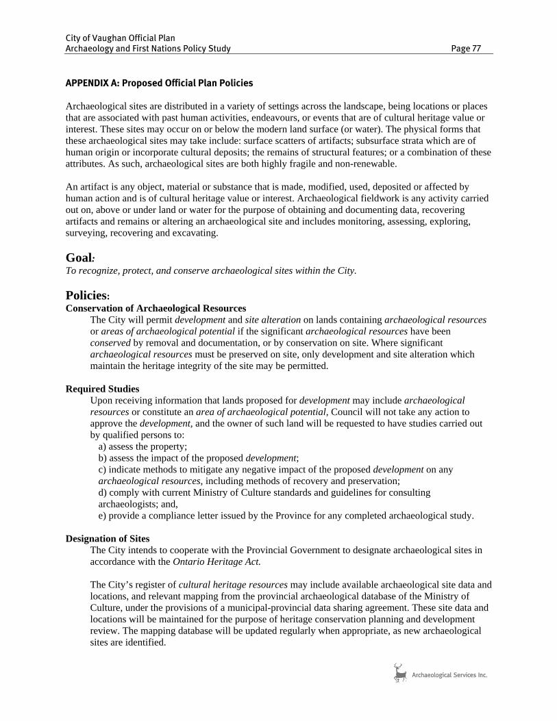
City of Vaughan Official Plan Archaeology and First Nations Policy Study Page 77
APPENDIX A: Proposed Official Plan Policies Archaeological sites are distributed in a variety of settings across the landscape, being locations or places that are associated with past human activities, endeavours, or events that are of cultural heritage value or interest. These sites may occur on or below the modern land surface (or water). The physical forms that these archaeological sites may take include: surface scatters of artifacts; subsurface strata which are of human origin or incorporate cultural deposits; the remains of structural features; or a combination of these attributes. As such, archaeological sites are both highly fragile and non-renewable. An artifact is any object, material or substance that is made, modified, used, deposited or affected by human action and is of cultural heritage value or interest. Archaeological fieldwork is any activity carried out on, above or under land or water for the purpose of obtaining and documenting data, recovering artifacts and remains or altering an archaeological site and includes monitoring, assessing, exploring, surveying, recovering and excavating.
Goal: To recognize, protect, and conserve archaeological sites within the City.
Policies: Conservation of Archaeological Resources
The City will permit development and site alteration on lands containing archaeological resources or areas of archaeological potential if the significant archaeological resources have been conserved by removal and documentation, or by conservation on site. Where significant archaeological resources must be preserved on site, only development and site alteration which maintain the heritage integrity of the site may be permitted.
Required Studies
Upon receiving information that lands proposed for development may include archaeological resources or constitute an area of archaeological potential, Council will not take any action to approve the development, and the owner of such land will be requested to have studies carried out by qualified persons to:
a) assess the property; b) assess the impact of the proposed development; c) indicate methods to mitigate any negative impact of the proposed development on any archaeological resources, including methods of recovery and preservation; d) comply with current Ministry of Culture standards and guidelines for consulting archaeologists; and, e) provide a compliance letter issued by the Province for any completed archaeological study.
Designation of Sites
The City intends to cooperate with the Provincial Government to designate archaeological sites in accordance with the Ontario Heritage Act.
The City’s register of cultural heritage resources may include available archaeological site data and locations, and relevant mapping from the provincial archaeological database of the Ministry of Culture, under the provisions of a municipal-provincial data sharing agreement. These site data and locations will be maintained for the purpose of heritage conservation planning and development review. The mapping database will be updated regularly when appropriate, as new archaeological sites are identified.

City of Vaughan Official Plan Archaeology and First Nations Policy Study Page 78
Locations Confidential
It is the policy of the City to keep confidential the existence and location of archaeological sites to protect against vandalism, disturbance, and the inappropriate removal of resources, as per the Ministry of Culture and the City of Vaughan data sharing agreement.
Provincial Approval
All archaeological assessment reports must be reviewed and a compliance letter issued by the Ministry of Culture. A copy of the assessment report and the compliance letter will be provided to the City by the licensed archaeologist who completed the assessment. The City will maintain copies of all reports and compliance letters for information purposes.
Burial Sites
Where burial sites are encountered during any excavation or other action, the provisions of the Cemeteries Act and its regulations will apply. Where First Nations burials are discovered, consultation will occur with the nearest First Nation and the Nation with the closest cultural affiliation, if that can be determined.
Emergency Protection of Resources
A contingency plan will be prepared, with the advice of a licensed archaeologist and the Ministry of Culture and adopted by by-law, for emergency situations to protect archaeological resources that are accidentally discovered or are under imminent threat(s).
First Nations Village Sites
All First Nations village sites shall be considered as features to be removed from developable lands.

City of Vaughan Official Plan Archaeology and First Nations Policy Study Page 79
APPENDIX B: Registered Archaeological Sites within the City of Vaughan
BORDEN NAME SITE TYPE
TEMPORAL CLASSIFICATION BORDEN NAME
SITE TYPE
TEMPORAL CLASSIFICATION
AkGu-14 Thornhill LW AC AlGu-320 * AR AF AkGu-15 Baker NA AC AlGu-321 Vitullo AR AC AkGu-16 Reaman LW AC AlGu-323 Cook's Mills 1 EC EC-D AkGu-30 Keelang 1 NA AF AlGu-324 Cook's Mills 2 EC EC-D AkGu-31 Keelang 2 NA AF AlGu-331 Kirby EC EC-D AkGu-36 Bathurst NA AC AlGu-333 Cook's Mills 4 EC EC-D AkGu-37 Beartrap LW NA AlGu-336 Thomas Cook EC EC-D AkGu-38 Lewis Page EC AC AlGu-337 Cook's Mills 5 EC EC-D AkGu-39 Thomas Page LW AC AlGu-338 Fisher EC EC-D AkGu-42 Windermere 1 AR AF AlGu-339 * AR AF
AkGu-43 Windermere 2 AR AF AlGu-340 Nine Ten West Precontact 3 AR AF
AkGu-44 Windermere 3 EC EC-D AlGu-341 Walkington 2 LW NA AkGu-46 Dufferin AR AF AlGu-347 Andridge AR AC AkGu-48 Deer Hoof AR AC AlGu-355 - EC EC-D AkGu-49 Caleb NA AF AlGu-48 Carrville 1 AR AF AkGu-50 Wild Canary I AR AF AlGu-49 Carrville 2 NA AF AkGu-51 Wild Canary II AR AF AlGu-50 Redelmeier 1 EW AF AkGu-52 Wild Canary III AR AF AlGu-51 Redelmeier 2 NA AC AkGu-53 AR AF AlGu-52 Redelmeier 3 NA AF AkGu-54 AR AF AlGu-53 Redelmeier 4 NA AF AkGu-55 Hawk MI AF AlGu-54 Southbrook AR AC AkGu-56 Two Pines LW AC AlGu-55 Redelmeier 5 NA AC AkGu-58 Clarke EC EC-D AlGu-56 Redelmeier 6 AR AF AkGu-60 Murray Knoll EC EC-D AlGu-57 Redelmeier 7 LW AF AkGu-61 Soules' Inn EC EC-N AlGu-58 Big Rock NA AF AkGu-62 AR AC AlGu-59 Redelmeier 8 NA AC AkGu-63 AR AF AlGu-60 Patch NA AF AkGu-67 Reaman Homestead EC EC-D AlGu-66 W. B. Peters EC AC AkGu-68 Jerrett EC EC-D AlGu-67 Stephenson NA AF AkGu-69 MacDonald Horse Barn EC EC-D AlGu-68 Patterson EC EC-I AkGv-1 LW AV AlGu-77 Mill Road LW AV AkGv-104 Burkholder House MC AC AlGu-8 McNair LW AV AkGv-105 AR AF AlGv-1 Kleinburg Ossuary HA B(o)
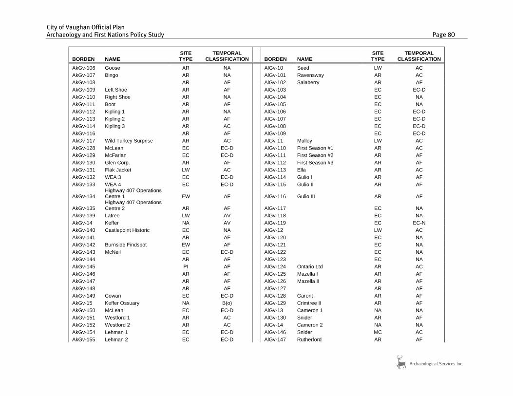
City of Vaughan Official Plan Archaeology and First Nations Policy Study Page 80
BORDEN NAME SITE TYPE
TEMPORAL CLASSIFICATION BORDEN NAME
SITE TYPE
TEMPORAL CLASSIFICATION
AkGv-106 Goose AR NA AlGv-10 Seed LW AC AkGv-107 Bingo AR NA AlGv-101 Ravensway AR AC AkGv-108 AR AF AlGv-102 Salaberry AR AF AkGv-109 Left Shoe AR AF AlGv-103 EC EC-D AkGv-110 Right Shoe AR NA AlGv-104 EC NA AkGv-111 Boot AR AF AlGv-105 EC NA AkGv-112 Kipling 1 AR NA AlGv-106 EC EC-D AkGv-113 Kipling 2 AR AF AlGv-107 EC EC-D AkGv-114 Kipling 3 AR AC AlGv-108 EC EC-D AkGv-116 AR AF AlGv-109 EC EC-D AkGv-117 Wild Turkey Surprise AR AC AlGv-11 Mulloy LW AC AkGv-128 McLean EC EC-D AlGv-110 First Season #1 AR AC AkGv-129 McFarlan EC EC-D AlGv-111 First Season #2 AR AF AkGv-130 Glen Corp. AR AF AlGv-112 First Season #3 AR AF AkGv-131 Flak Jacket LW AC AlGv-113 Ella AR AC AkGv-132 WEA 3 EC EC-D AlGv-114 Gulio I AR AF AkGv-133 WEA 4 EC EC-D AlGv-115 Gulio II AR AF
AkGv-134 Highway 407 Operations Centre 1 EW AF AlGv-116 Gulio III AR AF
AkGv-135 Highway 407 Operations Centre 2 AR AF AlGv-117 EC NA
AkGv-139 Latree LW AV AlGv-118 EC NA AkGv-14 Keffer NA AV AlGv-119 EC EC-N AkGv-140 Castlepoint Historic EC NA AlGv-12 LW AC AkGv-141 AR AF AlGv-120 EC NA AkGv-142 Burnside Findspot EW AF AlGv-121 EC NA AkGv-143 McNeil EC EC-D AlGv-122 EC NA AkGv-144 AR AF AlGv-123 EC NA AkGv-145 PI AF AlGv-124 Ontario Ltd AR AC AkGv-146 AR AF AlGv-125 Mazella I AR AF AkGv-147 AR AF AlGv-126 Mazella II AR AF AkGv-148 AR AF AlGv-127 AR AF AkGv-149 Cowan EC EC-D AlGv-128 Garont AR AF AkGv-15 Keffer Ossuary NA B(o) AlGv-129 Crimtree II AR AF AkGv-150 McLean EC EC-D AlGv-13 Cameron 1 NA NA AkGv-151 Westford 1 AR AC AlGv-130 Snider AR AF AkGv-152 Westford 2 AR AC AlGv-14 Cameron 2 NA NA AkGv-154 Lehman 1 EC EC-D AlGv-146 Snider MC AC AkGv-155 Lehman 2 EC EC-D AlGv-147 Rutherford AR AF

City of Vaughan Official Plan Archaeology and First Nations Policy Study Page 81
BORDEN NAME SITE TYPE
TEMPORAL CLASSIFICATION BORDEN NAME
SITE TYPE
TEMPORAL CLASSIFICATION
AkGv-159 AR AF AlGv-148 Greenwood AR AC AkGv-16 McNeil NA AC AlGv-149 AR AF AkGv-161 Hector McLean EC EC-D AlGv-15 Cameron 3 NA NA AkGv-162 Vaughan Mills EC EC-D AlGv-150 AR AF AkGv-163 Dickout EC EC-D AlGv-151 AR AF AkGv-164 AR AC AlGv-152 EC EC-D AkGv-17 Downey Ossuary NA B(o) AlGv-154 AR AF AkGv-175 AR AF AlGv-155 AR AF AkGv-177 Earth Rangers AR AC AlGv-156 AR AF AkGv-178 Boyd Berm MC AC AlGv-157 AR AF AkGv-179 Dring LW AF AlGv-159 McDonald EC EC-D AkGv-18 Kortright Sawmill NA AF AlGv-16 Kortright Kettle Lake Site NA NA AkGv-180 D-Ring MC EC-D AlGv-160 Vellore 1 AR AC AkGv-181 * AR AC AlGv-161 Killdeer LW NA AkGv-185 - EW AF AlGv-162 Vellore 2 AR AC AkGv-186 Roybridge EC EC-D AlGv-163 Vellore Farm EC EC-D AkGv-19 Tasca NA AF AlGv-165 McNaughton EC EC-D AkGv-190 Aliala AR AF AlGv-167 MacNaughton EC EC-D AkGv-2 McKenzie LW AV AlGv-168 McQuarrie 2 EC EC-D AkGv-20 Upper Nursery LW AC AlGv-170 Keffer Saw Mill EC EC-I AkGv-21 Johnson-Thain AR AC AlGv-171 Lazio EC EC-D AkGv-25 John Wray NA AF AlGv-176 AR AF AkGv-26 William Hartman NA AC AlGv-177 AR NA AkGv-265 Samuel Arnold EC EC-D AlGv-178 Nada AR AC AkGv-266 * EW AC AlGv-179 AR AF AkGv-267 * EW AF AlGv-18 Jarrett NA AV AkGv-268 Wardlaw EC EC-D AlGv-180 AR AF AkGv-269 Royal Pine NA AF AlGv-181 AR AF AkGv-27 Robert Johnson NA AC AlGv-182 EW AF AkGv-276 Burton EC EC-D AlGv-183 AR AF AkGv-277 Hunter LW AC AlGv-184 AR AC AkGv-28 AR AF AlGv-185 AR AF AkGv-29 Capner 1 AR AF AlGv-188 * AR AF AkGv-3 Boyd LW AV AlGv-189 Later AR AC
AkGv-30 Capner 2 NA AF AlGv-189.1 The Later Site NA NA
AkGv-31 John Smith Jr. EC AC AlGv-19 Train 1 NA AF AkGv-32 Weatherspoon 1 NA AF AlGv-191 AR AC AkGv-33 Weatherspoon 2 NA AF AlGv-192 AR AC

City of Vaughan Official Plan Archaeology and First Nations Policy Study Page 82
BORDEN NAME SITE TYPE
TEMPORAL CLASSIFICATION BORDEN NAME
SITE TYPE
TEMPORAL CLASSIFICATION
AkGv-34 Weatherspoon 3 NA AF AlGv-193 Skandatut HA AV AkGv-35 Longhouse 1 NA AF AlGv-194 The Richards site EC EC-D AkGv-36 George Longhouse EC AC AlGv-196 Hudwin EC EC-D AkGv-37 Longhouse 2 NA AF AlGv-199 Hope (North) LW AV AkGv-38 Longhouse 3 NA AC AlGv-199 Hope (South) LW AV AkGv-39 Longhouse 4 NA AF AlGv-2 Teston LW AV(o) AkGv-40 Farr 1 AR AC AlGv-20 Train 2 NA AF AkGv-41 Farr 2 NA AF AlGv-200 * AR AF AkGv-42 Farr 3 NA AF AlGv-201 * AR AF AkGv-43 Farr 4 NA AF AlGv-202 * AR AF AkGv-44 Farr 5 LW AF AlGv-203 * AR AF AkGv-45 Nancy Farr MC AC AlGv-204 J. McKinnon AR AF AkGv-46 Farr 6 NA AF AlGv-205 * AR AF AkGv-47 Farr 7 NA AF AlGv-207 The J. McKinnon site EC EC-D AkGv-48 Rainbow Creek PI AC AlGv-21 Train 3 NA AF AkGv-49 McNaughton 2 NA AC AlGv-215 * AR AF AkGv-50 McNaughton 3 NA AF AlGv-216 * AR AC AkGv-51 McNaughton 4 NA AF AlGv-217 * EC NA AkGv-52 McNaughton 5 AR AC AlGv-218 * EC EC-D AkGv-53 McNaughton 6 NA AF AlGv-219 * EC EC-D AkGv-54 McNaughton 7 NA AF AlGv-22 Train 4 NA AC AkGv-55 Weatherspoon 4 EI AF AlGv-220 * EC EC-D AkGv-56 McNaughton 8 NA AF AlGv-229 TACC NA AF AkGv-57 McNaughton 9 NA AF AlGv-23 Train 5 NA AF AkGv-58 Ellerby 1 NA AF AlGv-230 * AR AF AkGv-59 Ellerby 2 NA AC AlGv-231 Damiani LW AV AkGv-60 Boyd West NA AC AlGv-238 * NA AF AkGv-61 Constellation 1 NA AC AlGv-239 * NA AF AkGv-62 Reiss LW AC AlGv-24 Train 6 AR AC AkGv-63 Kline Mills EC EC-D AlGv-25 Train 7 NA AC AkGv-64 Playter 1 NA AC AlGv-26 Levaine Hamilton EC AC AkGv-65 Playter 2 NA AF AlGv-27 Train 8 NA AF AkGv-66 Daniel Reaman EC EC-D AlGv-28 North Humber 1 NA AF AkGv-67 Longhouse 5 AR AF AlGv-29 North Humber 2 NA AC AkGv-68 Dalmosh Site NA AC AlGv-30 North Humber 3 NA AF AkGv-69 Constellation 2 NA AC AlGv-31 North Humber 4 NA NA AkGv-72 Caragana AR AC AlGv-32 North Humber 5 NA AF AkGv-74 Fletcher EC EC-MC AlGv-33 North Humber 6 NA AF

City of Vaughan Official Plan Archaeology and First Nations Policy Study Page 83
BORDEN NAME SITE TYPE
TEMPORAL CLASSIFICATION BORDEN NAME
SITE TYPE
TEMPORAL CLASSIFICATION
AkGv-80 Sweet AR AF AlGv-34 Packers 1 NA AF AkGv-81 Sweet II AR AF AlGv-35 Packers 2 NA AC AkGv-82 Sweet III AR AC AlGv-36 Williams EC AC AkGv-83 Sweet IV AR AC AlGv-37 Packers 3 NA AC AkGv-84 Sweet V AR AC AlGv-38 Packers 4 NA AC AkGv-85 Sweet VI EW AF AlGv-39 ShurGain LW AV AkGv-87 AR AC AlGv-4 Fraser NA AC AkGv-88 AR AF AlGv-40 Able Kinnes EC EC-D AkGv-89 AR AC AlGv-41 Packers 5 NA AF AkGv-90 Thornbush TW AC AlGv-42 Packers 6 NA AF AkGv-91 Ageing Maple PI AC AlGv-43 Musselman EC AC AkGv-92 Dave's Dugout AR AF AlGv-44 Murray 1 NA AC AkGv-93 AR AF AlGv-45 Murray 2 NA AF AkGv-94 Collins AR AF AlGv-46 Murray 3 NA AC AkGv-95 Wonderland AR AF AlGv-47 Murray 4 NA AF AkGv-96 William Watson EC EC-D AlGv-48 Murray 5 NA AF AkGv-97 LW AC AlGv-49 Circle Ridge 1 NA AC AkGv-98 Bestway AR AC AlGv-5 AB AkGw-17 South Coleraine EC EC-D AlGv-50 Circle Ridge 2 NA AC AlGu-114 Running Deer AR AF AlGv-51 William Cook NA AF AlGu-124 EC NA AlGv-52 Isaac Murray 2 NA AF AlGu-166 AR AC AlGv-53 Isaac Murray EC AC AlGu-167 AR AC AlGv-54 Isaac Murray 3 NA AC AlGu-168 Feightner EC EC-D AlGv-55 Isaac Murray 4 NA AF AlGu-169 McDonald EC EC-D AlGv-56 Kinney 1 EC AC AlGu-170 McQuarrie 1 EC EC-D AlGv-57 Kinney 2 MI AC AlGu-171 Rupert EC EC-D AlGv-58 Packers 7 NA AC AlGu-172 Walkington EC EC-D AlGv-59 Packers 8 NA AC AlGu-173 Rumble EC EC-D AlGv-6 NA AC AlGu-174 AR AF AlGv-60 Packers 9 NA AF AlGu-175 Maplewood Ravines EW AC AlGv-61 AR NA AlGu-180 AR AF AlGv-62 Murray 6 NA AF AlGu-181 AR AF AlGv-63 Packers 11 NA AF AlGu-196 Edgar EC EC-D AlGv-64 Adams 1 NA AF AlGu-208 Sunhouse AR AC AlGv-65 Adams 2 AR AC AlGu-210 Memorial Park Cemetery EC EC-D AlGv-66 Adams 3 NA AF AlGu-211 Kerswill II MC NA AlGv-67 Kirby Sideroad NA NA AlGu-212 - AR AC AlGv-68 St. Paul's Site NA AC

City of Vaughan Official Plan Archaeology and First Nations Policy Study Page 84
BORDEN NAME SITE TYPE
TEMPORAL CLASSIFICATION BORDEN NAME
SITE TYPE
TEMPORAL CLASSIFICATION
AlGu-213 AR AC AlGv-69 Max NA AC AlGu-214 AR AF AlGv-7 AR AC AlGu-215 AR AC AlGv-70 Branta MC MC AlGu-216 EC EC-D AlGv-71 Dybal NA AC AlGu-217 Dufferin Camp AR AC AlGv-72 Amanda AR AC AlGu-22 Keelang 3 NA AF AlGv-73 Notamanda NA AC AlGu-23 AR AC AlGv-74 Lane NA AC AlGu-230 Campbell EC EC-D AlGv-75 Earl Site MW NA AlGu-236 Bennett EC EC-D AlGv-76 Balloon NA NA AlGu-238 Heatherwood EC EC-D AlGv-77 Gertrudis Site LW AC AlGu-239 Somme LW AC AlGv-78 Spike EW AC AlGu-298 The Shylow Site EC EC-D AlGv-79 Sirtalis NA AC AlGu-299 * AR AC AlGv-8 Malloy NA AC AlGu-307 * EW AF AlGv-80 Storeria AR AC AlGu-308 * AR AF AlGv-81 Furrow NA NA AlGu-309 * AR AC AlGv-82 Fieldgate EC EC-D AlGu-310 Parakeet AR NA AlGv-83 Hawthorn Mansion EC EC-D AlGu-311 * MW AF AlGv-85 Mako AR AF AlGu-312 * EC EC-D AlGv-9 AR AC AlGu-313 * EC EC-D AlGv-90 Kerrowood I AR AF AlGu-314 Senang LW AV AlGv-91 Kerrowood II AR AF AlGu-315 Woodvalley AR AC AlGv-92 Kerrowood III AR AF AlGu-316 Nine Ten West P1 AR AF AlGv-93 Kerrowood IV AR AF AlGu-317 Nine Ten West P2 AR AF AlGv-94 Kerrowood V EC EC-D AlGu-318 * AR AC AlGv-95 EC AC AlGu-319 * MW AF AlGv-96 Maple N'Hood 4 #1 AR AF AlGv-97 Judges AR AC