Embed Size (px)
Citation preview

CITY OF PORTLAND ADOPTED LAND USE PLAN
SUMMARY REPORT
City Comprehensive Plan and Zoning Code Amendments
APRIL 2011

Airport Futures City Land Use Plan ADOPTED BY CITY COUNCIL ON APRIL 13, 2011 ORDINANCE NO. 184521 EFFECTIVE DATE: MAY 13, 2011 FOR MORE INFORMATION, PLEASE CONTACT: Portland Bureau of Planning and Sustainability 1900 SW 4th Avenue, Suite 7100 Portland, Oregon 97201 503-823-7700 E-mail: [email protected] This report is available for viewing online at: www.portlandonline.com/bps
The Bureau of Planning and Sustainability is committed to providing equal access to information and hearings. If you need special accommodation, call the Bureau of Planning and Sustainability at 503-823-7700 (TTY 503-823-6868).

Acknowledgements Planning Advisory Group Bill Blosser, Chair Dave Smith, Vice Chair Erwin Bergman, Central NE Neighborhoods Mark Clark, East Multnomah County Andy Cotugno, Metro Bruce Fisher, Federal Aviation Administration John Frevola, Flightcraft Cam Gilmour, Clackamas County Gene Hahn, Horizon Airlines Alan Hargrave, Clark County Neighborhoods Chris Hathaway, Lower Columbia River Estuary Laura Hudson, City of Vancouver Maryhelen Kincaid, N Portland Neighorhood
Services Lt. Col. Stuart Mathew, OR Air National Guard Patrick Metzger, NE Coalition of Neighborhoods John Mohlis, Columbia Pacific Building Trades Dennis Mulvihill, Washington County Brian Nelson, Intel Mary Olson, Port Commission Lai-Lani Ovalles, Portland Planning Commission Alesia Reese, E Portland Neigh. Association Veronica Rinard, Travel Portland Hector Roche, Multnomah County Lawrence Russell, Coalition for a Livable Future Bob Sallinger, Audubon Michael Sloan, Vancouver Neighborhoods Denny Stoecklin, Portland Office of Neighborhood
Involvement Fred Stovel, Portland Office of Neighborhood
Involvement Vicki Thompson, Citizens’ Noise Advisory
Committee John Weigant, Airport Issues Roundtable
Portland City Council Sam Adams, Mayor Nick Fish, Commissioner Amanda Fritz, Commissioner Randy Leonard, Commissioner Dan Saltzman, Commissioner
Portland Planning Commission André Baugh Don Hanson Lai-Lani Ovalles Michelle Rudd Howard Shapiro Jill Sherman Chris Smith Irma Valdez
Bureau of Planning and Sustainability Susan Anderson, Director Joe Zehnder, Principal Planner Deborah Stein, Supervising Planner Jay Sugnet, Project Manager Mindy Brooks Jacob Brostoff Bronwyn Buckle Mark Raggett Jessica Richman Ralph Sanders
With additional assistance from: Sylvia Cate, Bureau of Development Services Stacey Castleberry, Bureau of Development Services Chris Corich, Port of Portland Kim Freeman, Bureau of Development Services Lise Glancy, Port of Portland John Gray, Bureau of Transportation Douglas Hardy, Bureau of Development Services David Helzer, Bureau of Environmental Services Nancy Hendrickson, Bureau of Environmental
Services Jamie Jeffrey, Bureau of Transportation Scott King, Port of Portland Sean Loughran, Port of Portland
Project Consultants CF Booth, Jacobs Consultancy Geoffrey Gosling, Aviation System Consulting Eric Hovee, Hovee and Associates Sam Imperati, Institute for Conflict Management Kelly Rodgers, DEA Alan Snook, DKS


ELEMENTS OF THE PLAN
Airport Futures was a collaborative effort between the City of Portland, Port of Portland, and the Portland-Vancouver metropolitan community to create an integrated long-range development plan for Portland International Airport (PDX). Beginning in fall 2007 and concluding in spring 2011, the Port updated the airport master plan and the City developed a land use plan recognizing PDX’s role in the regional economy while managing City infrastructure and livability. Planning Advisory Group Report – contains a summary of the Airport Futures planning process, final products, and the recommendations of the 30-member advisory group
Port of Portland 2010 PDX Master Plan – contains a summary of all the technical appendices related to the Port’s 2010 PDX Master Plan Update
Intergovernmental Agreements – provides the necessary bridge between the Port’s PDX Master Plan and the City’s Land Use Plan by memorializing Planning Advisory Group recommendations and City-Port agreements
City of Portland Land Use Plan Summary Report – contains the City’s portion of the Airport Futures Plan
Policy Framework............................................................................................................. 1 Provides the regulatory and policy framework in which the plan was developed
Urban Development Framework ..................................................................................... 1 Illustrates graphically many of the issues and ideas generated as part of the planning process
Natural Resources............................................................................................................ 9 Summarizes the large body of work related to natural resources
Comprehensive Plan Policy Amendments ..................................................................... 15
City Code and Map Amendments.................................................................................. 19 33.400 Aircraft Landing Zone........................................................................................ 21 33.470 Portland International Airport Noise Impact Zone........................................... 27 33.508 Cascade Station/Portland International Center Plan District ........................... 41 33.515 Columbia South Shore Plan District .................................................................. 71 33.565 Portland International Airport Plan District...................................................... 81 33.700 Administration and Enforcement ................................................................... 129 33.806 Airport Reviews............................................................................................... 131 33.815 Conditional Uses ............................................................................................. 135 33.900 List of Terms.................................................................................................... 139 33.910 Definitions ....................................................................................................... 139 33.920 Descriptions of the Use Categories................................................................. 141 Amended Plan District Boundaries Map...................................................................... 143 Comprehensive Plan Map Amendments ..................................................................... 145 Portland Plant List Amendments ................................................................................. 149

Appendices (under separate cover): City Zoning Map Amendments ........................................................................................................A Natural Resources Inventory ..........................................................................................................B Economic, Social, Environmental, and Energy Analysis ................................................................... C Transportation Impact Analysis .......................................................................................................D
Intergovernmental Agreements ...................................................................................................... E
Port and City of Portland General Agreement Port and City of Portland Natural Resources Agreement Port, Cities of Portland and Vancouver PDX Community Advisory Committee Agreement
To view the Planning Advisory Group Report, 2010 PDX Master Plan Update, or any of the appendices, visit the project website at www.pdxairportfutures.com. The documents are also on file with the Port’s Aviation Long Range Planning Department and the City’s Bureau of Planning and Sustainability.

April 2011 Page 1
POLICY FRAMEWORK The City’s Land Use Plan and the Port’s PDX Master Plan fit within a planning and policy framework that includes federal, state, regional and local policy as well as City adopted plans and regulations. Planning for the Airport Futures project must be consistent with the City of Portland’s adopted plans and policies, which must be consistent with regional plans and policies, as well as state and federal regulations and policies. The Planning Advisory Group received a summary of policies applicable to the Airport Futures project. Although each document reviewed contained many policies and regulations, only the most pertinent policies and information were summarized. The figure below illustrates the structure and hierarchy of planning that guided the Airport Futures project. Because the Port of Portland
must address airport specific policies and regulations, the Port prepared a companion document, Airport Regulations and Policy Guidelines, which describes the Federal Aviation Administration and state regulations and guidelines affecting the airport master planning process. The document also summarizes related Port of Portland policies. URBAN DEVELOPMENT CONCEPTS The graphics on the following pages identify many of the Social, Environmental, and Economic issues related to PDX and the area surrounding that emerged from the Airport Futures Planning process. Although the graphics are non-regulatory and non-binding on the City and Port, they provide a visual summary of the challenges of operating an airport in an urban context and illustrate the opportunities that lie ahead.

Page 2 Airport Futures Adopted City Land Use Plan

April 2011 Page 3

Page 4 Airport Futures Adopted City Land Use Plan

April 2011 Page 5

Page 6 Airport Futures Adopted City Land Use Plan

April 2011 Page 7

Page 8 Airport Futures Adopted City Land Use Plan

April 2011 Page 9
NATURAL RESOURCES SUMMARY Regulatory Requirements The City’s existing Environmental Program includes inventories of natural resources and application of environmental conservation and protection overlay zones to specific resources. The Environmental Program has been applied to different parts of the City over the past 20 years. The program was applied to natural resources within the Airport Futures project area in 1989, 1990 and 1993. Over the past 15-20 years, the location, extent and quality of resources have changed as development and restoration have occurred. Updating the City’s Environmental Program is a three-step process: Step 1: Update the natural resources inventory – Data, information and maps of key natural resource features and attributes such as waterway condition, banks, flood area, water quality, vegetation, wetlands, wildlife habitat, etc. are compiled. The methodology is based Metro’s approach to inventory riparian corridors and wildlife habitat across the region as part of Title 13 Nature in Neighborhoods. The Draft Natural Resources Inventory Project Report provides a context for the inventory, presents the scientific basis, and describes the project approach and methodology. The draft Middle Columbia Corridor/Airport Natural Resources Inventory can be found in Appendix C and is available for review and comment on the project web site. Below is a summary of some of the key natural resource areas:
Middle Slough The Middle Slough, a section of the main arm of the Columbia Slough, flows for 5 miles through the study area. The Middle Slough and associated waterways are completely surrounded by levees and are within the Multnomah County Drainage District (MCDD). The Middle Slough and riparian area serve as a wildlife travel corridor along the Lower Columbia River, Pacific Flyway, and other migratory bird pathways. More than 25 species of ducks, geese, swans, and raptors winter in the region, and neotropical migrant shorebirds and songbirds stop over in spring and fall. The Middle Slough is also home to American beaver, muskrat, northern river otter, several amphibian species, painted and western pond turtles, and 12 native fish species. The entire Columbia Slough is water quality limited for multiple pollutants including temperature; however, the Middle Slough has cooler water temperatures compared with the Upper Slough and Lower Slough, most likely because of cool groundwater inflows.
Whitaker Slough Approximately 3 ½ miles of the Whitaker Slough, a southern arm of the Middle Slough, is located in the study area. A narrow strip of riparian vegetation, two to three trees deep, surrounds Whitaker Slough. The dominant tree species include black cottonwood and red alder along with a heavily mixed understory of planted native trees and shrubs as well as invasive plants like Himalayan blackberry and Japanese knotweed. Wildlife using Whitaker Slough and the riparian area include beaver, nutria, coyote, Great Blue Heron, Great Horned Owl, goldfinch, black cap chickadee, Oregon junco, American robin, violet-green swallow, Cooper’s hawk and American widgeon. Migratory birds using Whitaker Slough include Western Tanager, Cassin’s Vireo, and Black-throated Gray Warbler. Fish found in Whitaker Slough include Three-spined Stickleback, Mosquitofish, and Prickly Sculpin.

Page 10 Airport Futures Adopted City Land Use Plan
Whitaker Ponds Whitaker Ponds consist of two ponds and surrounding riparian vegetation totaling about 14 acres just east of NE 47th Avenue. The forested banks of Whitaker Ponds are predominantly black cottonwood and red alder along with a heavily mixed understory of planted native trees and shrubs. The ponds provide habitat for turtles, wintering waterfowl, songbirds, nesting great horned owls, and other wildlife species. Whitaker Ponds has active groundwater upwelling areas, with visible springs, that helps keep the water temperatures cool during the summer. Buffalo Slough Buffalo Slough is a one-mile southern arm of the Columbia Slough in the vicinity of NE 33rd Drive. Buffalo Slough, like much of the southern arms of the slough, has significant areas of groundwater upwelling; cool water is a basic requirement for many aquatic species. The riparian area consists of a strip of trees one to two trees deep, predominantly comprised of black cottonwood, with an understory of Himalayan blackberry and English holly. Buffalo Slough and the surrounding vegetation provide habitat for a host of species including: American robin, marsh wren, redwing blackbird, Oregon junco, song sparrow, Anna’s hummingbird, mourning dove, mallard, ringneck duck, American widgeon, deer, coyote, river otter, beaver, carp and nutria. Peninsula Canal Peninsula Drainage Canal is a roughly 1.5 mile long isolated slough segment and is one of two known significant populations of Western painted turtles within the City of Portland. Western pond turtle and northern red-legged frog have been documented by the Oregon Department of Fish and Wildlife using the canal, as well as bull frog and carp. The area also provides habitat for numerous wildlife and provides connectivity to the Columbia River, Columbia Slough and small wetlands located near the canal including Blue Heron Meadows Wetland. Subaru Wetland Subaru Wetland is a 50-acre juncus/willow wetland and is surrounded by the Broadmoor Golf Course. Wetland vegetation includes cottonwood, ash, red osier dogwood, willow, Himalayan blackberry and rushes. Subaru Wetland is located near and provides wildlife connectivity to other small wetlands, drainageways, Peninsula Canal and the Columbia River. The wetland and vegetation provides habitat for song birds, waterfowl, woodpeckers, raptors and shorebirds, mammals and aquatic species including: common yellowthroat, song sparrow, robin, mourning dove, Vaux’s swift, scrub jay, mallard, bufflehead, varied thrush, savannah sparrows, Virginia rail, common snipe, deer, nutria, beaver and coyote. The use of fertilizers and pesticides and bird hazing at Broadmoor Golf Course may have negative impacts to water quality and habitat of the wetland and drainageways. Secondary Drainageways Located throughout the Columbia Slough watershed are numerous secondary drainageways. Drainageways are open linear depressions, whether constructed or natural, that function for the collection and drainage of surface water, subsurface flow or groundwater and may be permanently or temporarily inundated. In the Columbia Slough watershed, drainageways have been relocated, reconfigured, or even created over the past 100 years to allow for development – first agricultural, then industrial, commercial and residential. Although altered, these drainageways provide the critical watershed functions of the hydrologic system. They also provide habitat for numerous terrestrial, avian and aquatic wildlife species.

April 2011 Page 11
Uplands Unique to the Middle Columbia Corridor/Airport study area are uplands consisting of relatively large areas of sparse herbaceous vegetation that provide functions similar to that of a native prairie or grassland. Within the Metro region, native prairie habitat has dropped to less than 1% of historic extent. Much of the upland grasslands in the study area are managed by the Port of Portland to reduce habitat that attracts wildlife species of concern that pose a hazard to aviation safety (e.g., Canada goose; European starling). The upland grasslands also provide habitat for species that do not pose a risk to aviation safety including: Western meadowlarks, streaked horned lark, savannah sparrow, American pipit, Lazuli bunting, barn swallow, cliff swallow, Western kingbird, red-winged blackbird and yellow-headed blackbird. Golf Courses There are four golf courses within the study area. Drainageways, wetlands and riparian tree canopy are found at each golf course. A high concentration and diversity of migratory birds can be found using trees in the golf courses as stopover habitat. Bat species, including Myotis lucifugus, Eptesicus fuscus, Lasionycteris noctivagans, and Lasiurus cinereu, nest and roost in riparian trees and drink and forage over open water bodies. The golf courses also provide a wildlife connectivity corridor between other habitat such as Subaru Wetland, CRCI Wetland, Middle Slough, Buffalo Slough and Whitaker Slough. Columbia River The Columbia River is a migration channel for anadromous salmonids, including Chinook, Coho, chum, sockeye, and steelhead. Near shore, shallow water areas and areas of sandy substrate, such as Broughton Beach which is located just east of the Metro boat launch, are used by juvenile salmonids during migration to the Pacific Ocean. The Columbia River is designated by National Oceanic and Atmospheric Administration (NOAA) Fisheries as Critical Habitat for listed salmonids. The Columbia River is also part of the Pacific Flyway, which is a significant corridor for migratory birds. Broughton Beach and other shallow-water/sandy areas are used by shore birds, songbirds and migratory birds including streaked horned lark, red-necked grebe in shallow water, short-eared Owls, and western meadowlarks. Pisciverous diving birds use the near shore water for foraging: horned grebe, eared grebe, western grebe and common loon.
Step 2: Evaluate the tradeoffs between different levels of resource management – The tradeoffs of allowing, limiting, or prohibiting development within the inventoried natural resource areas were evaluated through an environmental, social, environmental, and energy (ESEE) analysis. The analysis is qualitative and is intended to identify key issues decision makers should consider in updating the natural resource protection program within the plan district. Economic factors considered were commerce, job creation, land supply, access to transportation alternative and ecosystem services. Social factors included public health, safety and welfare, recreation, education, cultural values and livability. Environmental factors included impacts on hydrology, water and air quality, habitat and aquatic and terrestrial wildlife. Energy factors focused on transportation requirements and infrastructure costs. The analysis concluded with recommendations regarding under what circumstances development and land uses within natural resources areas should be strictly limited (protection overlay zone), limited (conservation overlay zone) or allowed (no overlay zone). The City does not typically implement the “prohibit” option. Other City regulations and non-regulatory approaches were also considered.

Page 12 Airport Futures Adopted City Land Use Plan
The draft Middle Columbia Corridor/Airport Natural Resources ESEE Analysis can be found in Appendix D and is available for review and comment on the project web site.
Step 3: Adopt the updated inventory and apply the Environmental Program – Based on the results of steps 1 and 2, environmental overlay zones were refined and other program tools established to manage natural resources. The program components include an updated inventory of natural resources, an assessment of the economic, social, environmental and energy issues related to protecting resources, updates to the environmental overlay maps, Zoning Code amendments, and an Intergovernmental Agreement with the Port of Portland to address natural resource mitigation and enhancement associated with airport properties.

April 2011 Page 13
Recommend updates to environmental overlay zone maps include:
1. Applying a protection overlay zone to open water bodies, including Columbia Slough, Whitaker Slough, secondary drainageways and wetlands and land within 50 feet of those resources. Currently, the area between NE 82nd Avenue and Peninsula Slough has a conservation overlay zone. The protection overlay zone strictly limits development and preserves existing resources that provide multiple important riparian functions including microclimate, stormwater filtering, nutrient cycling, food web and wildlife habitat. This change also contributes towards city compliance with Metro Title 13 Nature in Neighborhoods and the Clean Water Act TMDLs for temperature;
2. Applying a conservation overlay zone to treed areas extending (contiguous) more than 50 ft from the water bodies. Tree canopy contiguous to water bodies out to 100 ft provides a number of riparian functions list above; and
3. Applying a conservation overlay zone to vegetated areas zoned open space (golf courses) extending 300 feet from water bodies. These vegetated areas provide important habitat for migratory birds and bats, some of which are listed as 'at risk' by the city. These areas also provide riparian functions.
For more property specific information on the proposal, please visit the project website or contact project staff. The Portland City Council did not adopt the environmental overlay mapping for industrially and commercially zoned properties as part of the Airport Plan District (with the exception of Port of Portland owned properties). This is due to the January 2011 legal challenge to similar regulations that were adopted as part of the City’s River Plan. The Land Use Board of Appeals remanded the River Plan back to the City for further consideration of Statewide Planning Goal 9 issues. Environmental Zones The updated environmental overlay zones generally apply to natural resources that provide a relatively high or medium amount of ecosystem function. The Airport Plan District code includes specific provisions intended to encourage habitat conversions that meet both the goals of improving watershed health and reducing habitat that attracts wildlife species of concern. City and Port staff and the Airport Futures Planning Advisory Group identified future desired conditions of existing natural resource areas that meet both goals by encouraging:
Conversion of herbaceous wetlands to native scrub-shrub or forested wetlands, Conversion of forest and woodland habitat to different native plant assemblages, and Reconfiguration of drainageway banks (i.e., benching) to improve flow, increase water storage
and provide native emergent wetland habitat. This section of code was removed as a result of the River Plan remand by the Land Use Board of Appeals. The Airport Plan District supports restoration of riparian corridor functions and wildlife habitat by requiring removal of paved surfaces and planting of native vegetation within environmental overlay zones. These restoration activities would be required as part of new development or redevelopment on sites that have an environmental overlay zone applied to a portion of the site.

Page 14 Airport Futures Adopted City Land Use Plan
Finally, the Airport Plan District requires that new road crossings of the Columbia Slough, Whitaker Slough, Buffalo Slough, Peninsula Canal, or Elrod Slough must be a bridge. Bridges support flow and hydrology within the waterways and improve water quality. A bridge allows terrestrial wildlife access from one side of the road to the other without risk of collision with traffic. Intergovernmental Agreement The Planning Advisory Group also recommended that the City and Port enter into an Intergovernmental Agreement to address required mitigation for upland grassland habitat on four Port properties – SW Quad, 33rd Field, Deicing Field, and Fuel Farm West – 268 acres total.
The Port agreed to build 300 acres of mitigation on Government Island in lieu of the City applying overlay zoning to the four parcels. This approach gives the Port additional flexibility and certainty for future development and it gives the City a more programmatic approach to restoration of upland grassland by requiring phased mitigation in one location prior to development. Voluntary/Nonregulatory As part of the natural resources package, the Planning Advisory Group recommended the following voluntary actions to achieve the overall goal of enhancement of the Columbia Slough Watershed: a) Port funded enhancements to the Columbia Slough watershed for 25 years starting at $30,000 per
year and escalating at 3% per year. Total Value: $1,094,000. b) Port funded enhancements to the urban tree canopy for 25 years starting at $20,000 per year and
escalating at 3% per year. Total Value: $729,000. Total value over the next 25 of those two watershed improvement commitments = $1,823,000. The details of the City-Port Agreement are found in Appendix E.

Comprehensive Plan Amendments
April 2011 Page 15
How to read The following pages show proposed changes to portions of the City’s Comprehensive Plan. Generally, language added to the Comprehensive Plan is underlined (example) and language deleted is shown in strikethrough (example).
Proposed Comprehensive Plan Goals and Policies
A Vision of Portland’s Future
Goals, Policies & Objectives
Goal 1 Metropolitan Coordination Goal 2 Urban Development Goal 3 Neighborhoods Goal 4 Housing Goal 5 Economic Development Goal 6 Transportation Goal 7 Energy Goal 8 Environment Goal 9 Citizen Involvement Goal 10 Plan Review and Administration Goal 11 Public Facilities Goal 12 Urban Design
GOAL 1 METROPOLITAN COORDINATION
1.6 Portland International Airport Partner with the Port of Portland to achieve the overall goal of Portland International Airport becoming the most sustainable airport in the world.
GOAL 5 ECONOMIC DEVELOPMENT 5.14 Portland International Airport Recognize the importance of the Portland International Airport to the bi-state economy
as a regional, national, and international transportation hub by including the Airport Futures Plan as part of this Comprehensive Plan.

Comprehensive Plan Amendments
Page 16 Airport Futures Adopted City Land Use Plan
GOAL 8 ENVIRONMENT 8.11 Special Areas
Recognize unique land qualities and adopt specific planning objectives for special areas. Objectives: I. Portland International Airport/Middle Columbia Slough
Conserve, restore, and enhance natural resource values through environmental zoning, voluntary strategies, and the implementation of special development standards in the plan district and the Portland International Airport/Middle Columbia Slough Natural Resources Management Plan.
POLICIES & OBJECTIVES – NOISE: 8.19 Noise Abatement Construction Requirements
Reduce and prevent excessive noise and vibration in attached residential dwelling through construction requirements.
8.20 Noise Abatement Strategies
Partner with the Port of Portland to Rreduce and prevent excessive noise levels from one use which may impact another use through ongoing noise monitoring and enforcement procedures. Explore creative new ways to address noise impacts.
8.21 Portland International Airport Noise Impact Area
Ensure compatible land use designations and development within the noise impacted area of the Portland International Airport while providing public notice of the level of aircraft noise and mitigating the potential impact of that noise within the area.
Objectives:
A. Promote land use compatibility within the noise impact area by prohibiting new residential development in areas within the 1977 Ldn 68 DNL or higher noise contour and by limiting the maximum residential zoning and Comprehensive Plan Map designations to R10 in R-designated areas and R1 in C-zoned areas located between the 1983 Ldn 65 DNL and the 1977 Ldn DNL 68 noise contours.
B. Minimize the potential impact of aircraft noise on those living and working within the within the 1983 65 DNL and the 1977 68 DNL noise contours by requiring sound insulation to achieve a day/night average interior noise level of 45 dBA for most structures.
C. Provide documentation of the level of aircraft noise to developers of residential property within the 1983 65 Ldn DNL and the 1977 68 Ldn DNL noise contours impact area and require their acknowledgment and acceptance of that level of aircraft noise through the completion of a noise disclosure statement and the dedication of a noise easement to the Port of Portland prior to construction.
D. Provide documentation of the level of aircraft noise to developers of residential property within the 2035 55 DNL noise contour and require their acknowledgment

Comprehensive Plan Amendments
April 2011 Page 17
and acceptance of that level of aircraft noise through the completion of a noise disclosure statement.
GOAL 11 PUBLIC FACILITIES
PORTLAND INTERNATIONAL AIRPORT GOAL & POLICIES: GOAL: 11J Promote a sustainable airport (PDX) by meeting the region’s air transportation needs
without compromising livability and quality of life for future generations. POLICIES & OBJECTIVES 11.63 Regulations
Implement the Airport Futures Plan through the implementation of the Portland International Airport Plan District and by including the Airport Futures Plan as part of this Comprehensive Plan.
Objectives:
A. Prohibit the development of a potential third parallel runway at PDX. Ensure a
transparent, thorough, and regional planning process if the Port of Portland demonstrates a need for its construction.
B. Support implementation of the Aircraft Landing Zone to provide safer operating conditions for aircraft in the vicinity of Portland International Airport by limiting the height of structures, vegetation, and construction equipment.
C. Support the Port of Portland’s Wildlife Hazard Management Plan by implementing airport specific landscaping requirements in the Portland International Airport Plan District to reduce conflicts between wildlife and aircraft.
11.64 Partnerships
Partner with the Port of Portland and the regional community to address the critical interconnection between economic development, environmental stewardship, and social responsibility. Objectives: Support an ongoing public advisory committee for Portland International Airport (PDX)
to: A. Support meaningful and collaborative public dialogue and engagement on airport
related planning and development;

Comprehensive Plan Amendments
Page 18 Airport Futures Adopted City Land Use Plan
B. Provide an opportunity for the community to inform the decision-making related to the airport of the Port, the City of Portland and other jurisdictions/organizations in the region; and
C. Raise public knowledge about the airport and impacted communities. 11.65 Investments
Ensure that new development and redevelopment of airport facilities supports the City’s and the Port’s sustainability goals and policies and is in accordance with Map 11.64.1. Objectives: Allow the Port flexibility in configuring airport facilities to preserve future development options, minimize environmental impacts, use land resources efficiently, maximize operational efficiency, ensure development can be effectively phased, and address Federal Aviation Administration’s airport design criteria.
Map 11.64.1

Zoning Code Amendments
April 2011 Page 19
How to read this document The following pages show adopted changes to the Zoning Code. Even numbered pages show code language with adopted changes. Language added to the Zoning Code is underlined and language deleted is shown in strikethrough. Odd-numbered pages contain staff commentary on the proposed changes.

Code Commentary
Page 20 Airport Futures Adopted City Land Use Plan
33.400.010 Purpose. The purpose statement is expanded to clarify that construction equipment, although temporary in nature, is a concern for aircraft safety in addition to structures and vegetation. 33.400.025 Relationship to Federal Regulations. This section clarifies the role of the Federal Aviation Administration (FAA). Specifically, the City’s height overlay complements Federal Aviation Regulations (FAR) issued and periodically updated by the FAA for the protection of airspace. FAR Part 77 allows the “FAA to identify potential aeronautical hazards in advance thus preventing or minimizing the adverse impacts to the safe and efficient use of navigable airspace”. Proposed development may meet the City’s height limit, but is still subject to review by the FAA through a 7460-1 Notice of Proposed Construction.

Zoning Code Amendments
April 2011 Page 21
AMEND CHAPTER 33.400 AIRCRAFT LANDING OVERLAY ZONE
Sections: 33.400.010 Purpose 33.400.020 Map Symbol 33.400.025 Relationship to Federal Regulations 33.400.030 Height Limits 33.400.040 Exceptions to Aircraft Landing Zone Height Limits 33.400.050 Letter of Approval Required Map 400-1 Aircraft Landing Overlay Zone Boundaries 33.400.010 Purpose The Aircraft Landing overlay zone provides safer operating conditions for aircraft in the vicinity of Portland International Airport by limiting the height of structures, and vegetation, and construction equipment. 33.400.020 Map Symbol The Aircraft Landing zone is shown on the Official Zoning Maps with a letter "h" map symbol (for height). 33.400.025 Relationship to Federal Regulations The Aircraft Landing overlay zone supplements, but is subordinate to, federal airspace regulations administered by the Federal Aviation Administration (FAA). Development and structures that meet the requirements of the Aircraft Landing Overlay Zone may still be subject to review by the FAA. 33.400.030 Aircraft Landing Zone Height Limits All structures, and vegetation, and construction equipment within the Aircraft Landing Overlay Zone are subject to the height limits of this section. Map 400-1 shows the boundaries of the overlay zone. The Aircraft Landing Overlay Zone Map , available in the Development Services Center shows the height limits. shown on the Aircraft Landing Zone Map. When the base zone height limit is more restrictive than the Aircraft landing zone height limit, the base zone controls. The Aircraft Land Zone Map is available for viewing at the Development Services Center.
A. E, I, and OS zones. In the Employment, Industrial, and Open Space zones, the height limits are shown on the Aircraft Landing Overlay Zone Map. When the base zone height is more restrictive than the Aircraft Landing Overlay Zone height, the base zone height applies. The Aircraft Landing Overlay Zone Map is available at the Development Services Center.

Code Commentary
Page 22 Airport Futures Adopted City Land Use Plan
33.400.040 Exceptions to Height Limits. An additional exemption for residential and commercially zoned lands is intended to address an administrative issue caused by the topography surrounding the airport. In some areas south of the airport, the height limit falls below ground level. This is caused by ground elevations rising from the airport up along the Alameda Ridge and on Rocky Butte. A height limit below ground level creates some administrative challenges.1 Therefore, the solution is to exempt from “h” overlay requirements all structures, vegetation, or construction equipment that do not exceed the base zone height limit for allowed uses in the residential or commercial zones. In some cases, the Federal Aviation Administration may still require review through their 7460-1 Notice of Proposed Construction process. This proposal was analyzed to determine if some situations may create a concern for aircraft safety. The fact that the area of this anomaly is well south of the airport and part of the overall topography of the City means that existing and future development will continue to be compatible with normal aircraft operations over this area. In addition, the current massing of structures and vegetation in the area is at, or sometimes above, the current base zone height limits. Tall structures that exceed the base zone height limits in the residential and commercial zones, such as cell phone towers, would continue to be subject to additional City reviews and not allowed outright. If changes to the base zone height limits are considered in the future by the City, an analysis will be necessary to determine if those proposed changes are in conflict with FAA Part 77 regulations. Although Title 33 does not regulate the height of vegetation and construction equipment, having those listed in the regulations provides guidance to the reader that any object that exceeds the height limits of the Chapter may require review by the FAA. 1 Federal Aviation Regulations (FAR) makes the following provision for this situation: “Any object that would be shielded by existing structures of a permanent and substantial character or by natural terrain or topographic features of equal or greater height, and would be located in the congested area of a city, town, or settlement where it is evident beyond all reasonable doubt that the structure so shielded will not adversely affect safety in air navigation.” (FAR Section 77.15)

Zoning Code Amendments
April 2011 Page 23
B. R and C zones. In the Residential and Commercial zones, structures are regulated by the base zone height limits rather than the height limits of this chapter.
C. All zones. In all zones, structures taller than the limits of Subsection A or B are
subject to Section 33.400.040.
33.400.040 Letter of Approval Required Exceptions to Height Limits An application for a building permit or land use review where the for a structure that will exceed the Aircraft Landing zone height limits of Section 33.400.030 or an application for an adjustment to the base zone height limit which will exceed the Aircraft Landing zone height limit, must be accompanied by an approval letter of approval from the Federal Aviation Administration. The letter, called "determination of no hazard to air navigation" states that the proposal will not create safety problems. The application for FAA approval may be obtained is available on the Federal Aviation Administration website or from the Aviation Department of the Port of Portland. 33.400.0450 Letter of Approval Required

Code Commentary
Page 24 Airport Futures Adopted City Land Use Plan
Map 400-1. Amendments to the Aircraft Landing Overlay Zone map. The “h” overlay was not applied to areas recently annexed into the City. Specifically, East Portland and East Hayden Island were annexed since the time when the “h” overlay was first applied. This error is now corrected.

Zoning Code Amendments
April 2011 Page 25

Code Commentary
Page 26 Airport Futures Adopted City Land Use Plan
33.470.010 Purpose. The existing City of Portland noise overlay, based on 1990 PDX DNL noise contours, regulates the density and construction of new residential structures. The City noise overlay requires that homes be sound insulated to ensure that noise is reduced to acceptable levels. Without sound insulation, residential uses are deemed to be incompatible with aircraft noise at levels higher than 65 DNL. The 65 DNL is the noise standard used by the Federal Aviation Administration (FAA), the State of Oregon Department of Environmental Quality (DEQ) the United States of Environmental Protection Agency (EPA), and United States Department of Housing and Urban Development (HUD). The City noise overlay requires that the effectiveness of the sound insulation be certified by a licensed acoustical engineer paid for by the Port (usually costs about $1,000), and that the Port receive both a noise easement and a disclosure statement. Since adoption of the requirements in 1985, 310 homes, condos, and townhomes have been built with certified acoustic insulation, easements, and/or disclosure statements dedicated to the Port. The overlay has promoted land use compatibility by allowing only sound insulated homes to be built in an area most impacted by aircraft noise. Based on the noise analysis completed for Airport Futures in 2009, the Airport Futures Planning Advisory Group (PAG) recommend that the current City noise overlay (based upon the 1990 65 DNL noise contour) be retained in City code to address the anticipated growth in noise contours and ensure land use compatibility over the long term within the 65 DNL and higher noise contours. The analysis of future airport noise contours was based upon accepted growth scenarios, including dual stream departures, triple stream departures (3rd parallel runway) and operations in excess of 500,000. The analysis does not show a need for expansion of the current City noise overlay based on comparison with the future 65 DNL contour. An expansion of the City noise overlay is not necessary to prevent incompatible uses within the 65 DNL noise contour that would be associated with anticipated future growth at PDX. The existing 1990 City noise overlay is larger than both the base case 2008 65 DNL and 2035 50th percentile 65 DNL contours, and there are only marginal areas where the 2035 90th percentile 65 DNL extends beyond that overlay. Continuing to use that contour is a policy choice intended to provide a measure of extra protection for residents by applying the extra sound insulation standards for new development in an area that is larger than the current 65 DNL contour. 33.470.030 Where These Regulations Apply. Language was added to the purpose statement clarifying that the 65 and 68 DNL noise contours are derived from the 1990 noise study and the 55 DNL is derived from the 2009 noise study. 33.470.030 – 33.470.060. DNL is day-night average sound level (DNL) in decibels (dB). DNL, rather than Ldn, is currently the industry standard abbreviation. Although the two acronyms are synonymous, all references to Ldn were changed to DNL.

Zoning Code Amendments
April 2011 Page 27
AMEND CHAPTER 33.470 PORTLAND INTERNATIONAL AIRPORT NOISE IMPACT OVERLAY ZONE
Sections: 33.470.010 Purpose 33.470.020 Short Name and Map Symbol 33.470.030 Where These Regulations Apply 33.470.030 Applying the PDX Noise Zone 33.470.035 Corrections 33.470.040 Regulations for Residential UsesNoise Insulation 33.470.050 Additional Residential Regulations 33.470.010 Purpose The Portland International Airport Noise Impact overlay zone reduces the impact of aircraft noise on development within the noise impact area surrounding the Portland International Airport. The zone achieves this by limiting residential densities and by requiring noise insulation, noise disclosure statements, and noise easements. 33.470.020 Short Name and Map Symbol The Portland International Airport Noise Impact zone is also referred to as the PDX Noise zone, and is shown on the Official Zoning Maps with a letter "x" map symbol (for PDX). 33.470.030 Applying the PDX Noise Zone
A. Noise Contour Boundary Source. The Ldn 65 noise contour, as shown in the 1990
Portland International Airport Noise Abatement Plan Update is the boundary for the PDX Noise zone. All land within that noise contour, including lands within a higher contour, is in the PDX Noise zone and subject to these regulations.
B. PDX Noise Zone Maps. A set of quarter-section maps, known as the PDX Noise Zone Maps, is available for review at the Development Services Center. The maps are the official reference maps for the PDX Noise zone regulations. The maps show the Ldn 65 noise contour and each successively higher noise contour in oneLdn increment. The location of the noise contours are based on the 1990 Portland International Airport Noise Abatement Plan Update. The Ldn 68 noise contour location was established by the Port of Portland.
C. Application on annexed land. The PDX Noise zone is to be applied on all annexed areas located within the Ldn 65 or higher noise contours as part of the annexation rezoning of that area.
D. Corrections. An owner may request that the Planning Director initiate a correction to the location of the noise contours shown on the PDX Noise Zone Maps for their property. The owner must show, and the Director must find, that the noise contours do not conform with the location shown in the 1990 Portland International Airport Noise Abatement Plan Update. Corrections are Corrections are processed as stated in 1.01.037.
33.470.030 Where These Regulations Apply The regulations of the chapter apply within the Portland International Airport Noise Impact

Code Commentary
Page 28 Airport Futures Adopted City Land Use Plan

Zoning Code Amendments
April 2011 Page 29
Overlay Zone. There are several contours within the zone. The boundaries of the 65 DNL and 68 DNL noise contours are based on the 1990 Portland International Airport Noise Abatement Plan. The 55 DNL noise contour is based on the 2035 50th Percentile Forecast Noise Exposure Map in the 2010 Portland International Airport Master Plan Update. A set of quarter-section maps, known as the PDX Noise Zone Maps, is available for viewing at the Development Services Center. The maps are the official reference maps for the PDX Noise Zone regulations. The maps show the 55 DNL noise contour and each successively higher noise contour in one DNL increments. 33.470.035 Corrections An owner may request that the Planning and Sustainability Director initiate a correction to the location of the noise contours shown on the PDX Noise Zone Maps for their property. The owner must show, and the Director must find, that the noise contours do not conform with the location shown in the 1990 Portland International Airport Noise Abatement Plan Update for the location of the 65 and 68 DNL contours, or the 2010 Portland International Airport Master Plan Update for the location of the 55 DNL contour. Corrections are processed as stated in Section 1.01.037 of the Portland City Code.

Code Commentary
Page 30 Airport Futures Adopted City Land Use Plan
33.470.040 Regulations for Residential Uses. These amendments are largely intended to improve clarity by reorganizing the contents. 33.470.040.A adds a requirement for a noise disclosure statement for new residential construction or reconstruction.
RESIDENTIAL LAND USE ANALYSIS
Total Acres
Total Acres Zoned
Residential
Percent Acres Zoned
Residential (1)
Total Number of Tax Lots Zoned
Residential
Total Vacant
Acres (2)
Housing Capacity of Vacant Land (3)
1990 City Noise Overlay 7,125 477 10.6% 715 24 Less than one unit
2008 65 DNL 3,786 14 0.6% 16 3 206
2035 50th Percentile 65 DNL 5,101 28 0.9% 29 4.2 Less than one unit
2035 90th Percentile (Dual Stream) 65 DNL
6,365 65 1.8% 74 4.2 Less than one unit
2035 90th Percentile (3 Runways) 65 DNL
7,113 169 3.9% 518 17 116
2035 50th Percentile (Dual Stream) 55 DNL
28,103 2,378 14.3% 5,756 NA NA
2035 50th Percentile (Dual Stream) 55 DNL – City of
Portland only 12,181 1,132 14.9% 2,052 119 809
(1) Percentage is based on buildable acres which is total acres minus rights of way and the river (2) Metro Vacant Lands Inventory, 2007 (3) Metro 2040 Compliance Report, 1999, includes only residentially zoned land
The above analysis shows that although the 2008 noise contours are significantly smaller than 20 years ago, the contours will grow to the 1990 levels again with the forecasted growth in aviation. The question this housing capacity column is answering relates to the opportunity cost (in terms of lost housing units) of not shrinking the noise contour to current levels. If the City’s current noise overlay were modified based on the 2008 noise contour, approximately 206 housing units could be built. Despite this fact, the PAG recommendation is to keep the current noise overlay provisions in recognition that any homes built in the 1990 overlay would be severely impacted by aircraft noise.

Zoning Code Amendments
April 2011 Page 31
33.470.040 Noise Insulation
A. Noise insulation required. All new structures must be constructed with sound insulation or other means to achieve a day/night average interior noise level of 45 dBA. Reconstructed structures where the total cost of improvements is 75 percent or more of the total assessed improvement value of the site must also meet this standard. Garages and similar accessory structures that do not include living space, and structures used for Manufacturing And Production uses, Warehouse And Freight Movement uses, or nonresidential Agricultural uses are exempt from this requirement.
B. Certified by acoustical engineer. An engineer registered in Oregon who is knowledgeable in acoustical engineering must certify that the building plans comply with the performance standard for sound insulation prior to the issuance of a building permit.
C. City provides list. The City, in consultation with the Department of Environmental Quality and the Port of Portland, will provide a list of at least three registered engineers knowledgeable in acoustical engineering.
D. Port of Portland pays for sound insulation certification. At an owner's request, the Port of Portland is responsible for the costs of the noise insulation certification submitted by an engineer on the City list. The owner has the option to retain any registered engineer knowledgeable in acoustical engineering not on the list, at the owner's expense.
33.470.040 Regulations for Residential Uses
A. Noise disclosure statement in the 55, 65, and 68 DNL. The regulations of this subsection apply to sites in the 55, 65, and 68 DNL contours. Before a building permit is issued for new residential construction or reconstruction where the total cost of improvements is 75 percent or more of the total assessed improvement value of the site, the owner must sign the City's noise disclosure statement. The noise disclosure statement acknowledges that the property is located within the 55, 65, or 68 DNL noise contour and signifies the owner's awareness of the associated noise levels. The noise disclosure statement must be recorded in the County records by the owner. A packet containing the noise disclosure statement is available at the Development Services Center.
B. Noise easement in the 65 and 68 DNL. The regulations of this subsection apply to
sites in the 65 and 68 DNL contours. Before a building permit is issued for new residential construction or reconstruction where the total cost of improvements is 75 percent or more of the total assessed improvement value of the site, the owner must dedicate a noise easement to the Port of Portland. The easement authorizes aircraft noise impacts over the grantor's property at levels established by the DNL noise contour. Any increase of the DNL noise level above that stated on the easement will not void nor be protected by the easement. The easement forms are available at the Development Services Center.

Code Commentary
Page 32 Airport Futures Adopted City Land Use Plan
33.470.040.C. Noise Insulation required in 65 and 68 DNL. Amendments clarify that reimbursement by the Port of Portland is for certification by a licensed acoustical engineer, not any other services or materials. It also clarifies that certification reimbursement is for residential development only. Nonresidential development is expected to pay for certification. 33.470.040.C.1. A reference to the Department of Environmental Quality was removed since the department’s noise program is no longer funded and therefore they are not able to consult with the City and Port in updating the list of acoustical engineers. The Bureau of Development Services updates the list annually.

Zoning Code Amendments
April 2011 Page 33
C. Noise insulation required in 65 and 68 DNL. The regulations of this subsection
apply to sites in the 65 and 68 DNL contours. New dwelling units allowed by this chapter within the 65 and 68 DNL contours must be constructed with sound insulation or other means to achieve a day/night average interior noise level of 45 dBA. Reconstructed dwelling units where the total cost of improvements is 75 percent or more of the total assessed improvement value of the site must also meet this standard. Garages and similar accessory structures that do not include living area are not subject to this requirement.
1. Certified by acoustical engineer. An engineer registered in Oregon who is licensed
in acoustical engineering must certify that the building plans comply with the performance standard for sound insulation prior to the issuance of a building permit.
2. City provides list. The City, in consultation with the Port of Portland, will provide
a list of at least three registered engineers licensed in acoustical engineering. 3. Port of Portland pays for sound insulation certification. At an owner's request, the
Port of Portland is responsible for the costs of the noise insulation certification of dwelling units submitted by an engineer on the City list. The Port of Portland will pay for the cost of the certification required by this section, but not design, materials, or labor costs associated with installing the sound insulation. The owner has the option to retain any registered engineer licensed in acoustical engineering not on the list, at the owner's expense.
D. Residential use and density.
1. Within the 68 DNL noise contour. Where any part of a site is within the 68 DNL
noise contour, it is subject to the following:
a. New residential uses.
(1) New residential uses prohibited. New residential uses are prohibited within the 68 DNL or higher noise contour except as allowed specifically by this subsection. If a site is divided by a 68 DNL noise contour all dwelling units must be located entirely outside the 68 DNL noise contour.
(2) Exemption. Sites that had a Farm and Forest, Limited Single Family,
Low Density Single Family, or Medium Density Single Family Comprehensive Plan Map designation on January 1, 1981 or a County Residential Comprehensive Plan designation or zoning on that date are exempt from this prohibition. Dwelling units added to these sites must meet the requirements of this chapter for

Code Commentary
Page 34 Airport Futures Adopted City Land Use Plan
33.470.040 Regulations for Residential Uses. These amendments are largely intended to improve clarity by reorganizing the contents. Although the Airport Futures Planning Advisory Group recommends leaving the City noise overlay boundary where it is today for acoustic certification, easements and noise disclosures, the group supports a new noise overlay extending out from the current 1990 65 DNL to include land within the 2035 50th Percentile Forecast 55 DNL contour for the limited purpose of noise disclosure for new development (no easements or other provisions of the existing noise overlay – just disclosure). The disclosure would state that the home is in an area subject to aircraft overflight by jets and other aircraft arriving and departing PDX and that some people may be bothered by the aircraft flying overhead. A copy of the current disclosure statement is available on the City’s website http://www.portlandonline.com/bds/index.cfm?c=45494&a=219419. The figure below illustrates the area creating a new overlay zone which extends to the 2035 50th Percentile Forecast 55 DNL noise contour from the existing 1990 65 DNL contour.
33.470.040.D.1.b.(2) Natural Disasters. This code provision originated in the Hayden Island planning process and this plan is applying the provision to the entire noise overlay in recognition of the unique set of issues related to manufactured dwelling parks

Zoning Code Amendments
April 2011 Page 35
residential development within the 65 DNL contour. b. Replacement housing.
(1) Existing housing within the 68 DNL noise contour may be replaced
within 5 years if it is damaged or destroyed by fire or other causes beyond the control of the owner. A houseboat that is intentionally removed from its slip by the owner may be replaced within 5 years. A manufactured dwelling that is intentionally removed from a manufactured dwelling park may be replaced within 5 years.
(2) Natural disasters. The replacement time of 5 years is extended to 15
years for manufactured dwelling parkson Hayden Island if: • Manufactured dwelling units are damaged or destroyed by a natural
disaster such as a flood, earthquake, fire or other causes beyond the control of the manufactured dwelling park owner; and
• At least 30 percent of the manufactured dwelling units in the
manufactured dwelling park are either destroyed or significantly damaged. A unit is significantly damaged if the repair cost is 75 percent of the value of the unit.
2. Within the 65 DNL noise contour. Where a site is within the 65 DNL noise
contour, it is subject to the following:
a. Sites that have a residential Comprehensive Plan Map designation are prohibited from developing to a residential density higher than that of the R10 zone.
b. Except as provided in paragraph D.3, sites that have a commercial
Comprehensive Plan Map designation are prohibited from developing to a residential density higher than that of the R1 zone.
3. In the Hayden Island plan district, residential density may be transferred as
specified in 33.532.240.
33.470.050 Additional Residential Regulations
A. Restrictions on residential use and density.
1. Within the Ldn 68 noise contour. Where any part of a site is within the Ldn 68 noise contour, it is subject to the following:
a. New residential uses prohibited. New residential uses are prohibited within
the Ldn 68 or higher noise contour except as allowed specifically by this subsection, If a site is divided by an Ldn 68 noise contour all dwelling units, accessory structures, and required side and rear setbacks

Code Commentary
Page 36 Airport Futures Adopted City Land Use Plan

Zoning Code Amendments
April 2011 Page 37
must be located entirely outside the Ldn 68 noise contour. b. Replacement housing.
Existing housing within the Ldn 68 noise contour may be replaced within 5 years if it is damaged or destroyed by fi re or other causes beyond the control of the owner. A houseboat that is intentionally removed from its slip by the owner may be replaced within 5 years. A manufactured dwelling that is intentionally removed from a manufactured dwelling park may be replaced within 5 years.
(2) Natural disasters. The replacement time of 5 years is extended to 15 years for
manufactured dwelling parks on Hayden Island if: • Manufactured dwelling units are damaged or destroyed by a natural
disaster such as a flood, earthquake, fire or other causes beyond the control of the manufactured dwelling park owner.
• At least 30 percent of the manufactured dwelling units in the
manufactured dwelling park are either destroyed or significantly damaged. A unit is significantly damaged if the repair cost is 75 percent of the value of the unit.
c. Exemption. Sites that had a Farm and Forest, Limited Single Family, Low
Density Single Family, or Medium Density Single Family Comprehensive Plan Map designation on January 1, 1981 or a County Residential Comprehensive Plan designation or zoning on that date is are exempt from this prohibition. Dwelling units added to these sites must meet the requirements of this chapter for residential development within the Ldn 65 contour.
2. Within the Ldn 65 noise contour. Where a site is within the Ldn 65 noise contour,
it is subject to the following:
a. Sites that have a residential Comprehensive Plan Map designation are prohibited from developing to a density higher than that of the R10 zone.
b. Except as provided in subparagraph A.3, sites that have a commercial
Comprehensive Plan Map designation are prohibited from being developed at a density higher than that of the R1 zone.
3. In the Hayden Island plan district, residential density may be transferred as specified in 33.532.240.
B. Noise disclosure statement. Prior to the issuance of a building permit for new
residential construction or reconstruction where the total cost of improvements is 75 percent or more of the total assessed improvement value of the site, the owner

Code Commentary
Page 38 Airport Futures Adopted City Land Use Plan

Zoning Code Amendments
April 2011 Page 39
must sign the City's noise disclosure statement. The noise disclosure statement acknowledges that the property is located within the Ldn 65 noise contour and signifies the owner's awareness of the associated noise levels. The noise disclosure statement must be recorded in the County records by the owner. The statement is available at the Development Services Center.
C. Noise easement. Prior to the issuance of a building permit for new residential construction or reconstruction where the total cost of improvements is 75 percent or more of the total assessed improvement value of the site, the owner must dedicate a noise easement to the Port of Portland. The easement forms are available at the Development Services Center. The easement authorizes aircraft noise impacts over the grantor's property at levels established by the Ldn noise contour. Any increase of the Ldn noise level above that stated on the easement will not void nor be protected by the easement.

Code Commentary
Page 40 Airport Futures Adopted City Land Use Plan
33.508.230-240 Landscaping These amendments to the Cascade Station/PIC plan district landscaping regulations make them consistent with the landscaping regulations of chapter 33.565. 33.508.300-340 Environmental Zones The environmental zones section of the Cascade Station/Portland International Center Plan District is being replaced.

Zoning Code Amendments
April 2011 Page 41
AMEND CHAPTER 33.508 CASCADE STATION/PORTLAND INTERNATIONAL CENTER (CS/PIC)
PLAN DISTRICT Sections: Development Standards 33.508.230 Development and Design Standards in Subdistrict A 33.508.240 Development and Design Standards in Subdistrict B Environmental Overlay Zones 33.508.300 Purpose 33.508.305 Where These Regulations Apply 33.508.310 Overlay Zones 33.508.312 Items Subject to These Regulations 33.508.320 Use Regulations 33.508.330 Development Standards 33.508.340 CS/PIC Environmental Review Map 508-2 Areas Where Environmental Transition Area is 0 Feet 33.508.300 Purpose 33.508.310 Relationship to Other Environmental Regulations 33.508.320 Where and When These Regulations Apply 33.508.330 Measuring Setbacks 33.508.340 Exemptions 33.508.350 Development Standards 33.508.360 General Development Standards 33.508.370 Standards for Resource Enhancement 33.508.380 Special Procedures for Wildlife Hazard Management Notice and Review Procedure for Permits within Environmental Overlay Zones 33.508.392 Purpose 33.508.395 When These Regulations Apply 33.508.397 Procedure [Modify 33.508.230 and 33.508.240. Delete 33.508.300-33.508.340 and Map 508-2. Replace with new sections 33.508-300-33.508.397, below] 33.508.230 Development and Design Standards in Subdistrict A
A. and B. [No change]
C. All areas of Subdistrict A. All development in Subdistrict A of the plan district must meet the following:
1. through 3. [No change]
4. Landscaping must meet the standards of Section 33.565.220, Landscaping, that
apply in the Airport Subdistrict.
a. Purpose. Plant selection is an especially important component of the CS/PIC Plan District. Because the plan district is near the runways of Portland International Airport and existing natural features and ecosystems (such as the Columbia Slough), bird strikes are a significant

Code Commentary
Page 42 Airport Futures Adopted City Land Use Plan

Zoning Code Amendments
April 2011 Page 43
hazard to aircraft. In an effort to reduce this hazard, the approved CS/PIC Plant List provides a selection of plant materials which may be used in the plan district. These plants were selected because they do not attract wildlife; they do not provide attractive roosting habitat for species posing a threat to aviation safety and are generally non-seeding or nonfruiting.
b. Required landscaping. Other than landscaping required for parking lots, no
landscaping is required. c. Parking lot landscaping. Parking lot landscape requirements are in Chapter
33.266, Parking and Loading, and in C.4.d below. d. Allowed landscaping materials and plant spacing.
(1) All landscaping must use only plants listed in the approved CS/PIC Plant List. In addition, landscaping must not contain plants listed on the City of Portland’s Prohibited or Nuisance Plant Lists.
(2) All trees must meet the spacing standards listed in the approved CS/PIC
Plant List. Where meeting the spacing standards would result in fewer trees than required by other provisions of this Title, the number of trees required is reduced by the number needed to meet the spacing standard of the CS/PIC Plant List.
(3) No more than 50 percent of shrubs may be evergreen shrubs.

Code Commentary
Page 44 Airport Futures Adopted City Land Use Plan

Zoning Code Amendments
April 2011 Page 45
33.508.240 Development and Design Standards in Subdistrict B The regulations of this section apply to all development in Subdistrict B of the plan district.
A. and B. [No change]
C. Landscaping. Landscaping must meet the standards of Section 33.565.220,
Landscaping, that apply in the Airport Subdistrict.
1. Purpose. Plant selection is an especially important component of the CS/PIC Plan District. Because the plan district is near the runways of Portland International Airport and existing natural features and ecosystems (such as the Columbia Slough), bird strikes are a significant hazard to aircraft. In an effort to reduce this hazard, the approved CS/PIC Plant List provides a selection of plant materials which may be used in the plan district. These plants were selected because they do not attract wildlife; they do not provide attractive roosting habitat for species posting a threat to aviation safety and are generally non-seeding or non-fruiting.
2. Required landscaped area. The minimum landscaped area is 7.5 percent of each
lot. 3. Parking lot landscaping. Parking lot landscape requirements are in Chapter
33.266, Parking and Loading, and in C.3.b, below. 4. Allowed landscaping materials and plant spacing.
a. All landscaping must use only plants listed in the approved CS/PIC Plant List. In addition, landscaping must not contain plants listed on the City of Portland’s Prohibited or Nuisance Plant Lists.
b. All trees must meet the spacing standards listed in the approved CS/PIC
Plant List. Where meeting the spacing standard would result in fewer trees than required by other provisions of this Title, the number of trees required is reduced by the number needed to meet the spacing standard of the CS/PIC Plant List.
c. No more than 50 percent of shrubs may be evergreen shrubs.

Code Commentary
Page 46 Airport Futures Adopted City Land Use Plan
33.508.300 Purpose The purpose of the replacement is to manage the natural resources within the CS/PIC Plan District consistent with natural resources in the Portland International Airport Plan District. The intent is to encourage natural resource management that reduces use by specific high-risk wildlife species of concern and reduces vertical intrusions into protected surfaces, while also maintaining and enhancing resource features and functional values. Public safety is broad and includes aviation safety. These regulations only apply to areas where the environmental overlay zones are present. If an inventoried natural resource exists outside of the overlay zones, it is not subject to these regulations. 33.508.310 Relationship to Other Environmental Regulations This includes a roadmap for the code user to follow in navigating between chapter 33.430 and 33.508.

Zoning Code Amendments
April 2011 Page 47
Environmental Overlay Zones
33.508.300 Purpose The purposes of the environmental code in the Cascade Station/Portland International Center (CS/PIC) Plan District in conjunction with the standards of Chapter 33.430 are to:
• Protect inventoried significant natural resources and their functional values specific to the CS/PIC Plan District, as identified in the Comprehensive Plan;
• Address activities required to manage Port facilities, drainageways and wildlife around the Portland International Airport airfield for public and avian safety;
• Address resource mitigation and enhancement opportunities consistent with managing wildlife and vegetation on and around the airfield for public safety;
• Encourage coordination between City, county, regional, state, and federal agencies concerned with airport safety and natural resources; and
• Protect inventoried significant archaeological resources where those resources overlap with an environmental protection zone or environmental conservation zone.
33.508.310 Relationship to Other Environmental Regulations The regulations of Sections 33.508.310 through 33.508.380 are supplemental to or supersede the regulations of Chapter 33.430. Whenever a provision of this plan district conflicts with Chapter 33.430, the plan district provision supersedes.
Specifically, the following sections of Chapter 33.430 are superseded or supplemented by the regulations of sections 33.508.310 through 33.508.380:
Exemptions in 33.508.340 supplement section 33.430.080; Standards in 33.508.360 supplement, with portions superseding, sections 33.430.140-
.190; Procedures for Environmental Review, section 33.430.230, are superseded by section
33.508.380 when Wildlife Hazard Management is proposed; Submittal requirements for Environmental Reviews of section 33.430.240 are
superseded and supplemented by 33.508.380; Environmental Plan Check notice and review procedures of 33.430.410-.430 are
completely superseded by 33.508.392-.397.
This chapter contains only the City’s environmental regulations. Activities which the City regulates through this chapter may also be regulated by other agencies. City approval does not imply approval by other agencies.
33.508.320 Where and When These Regulations Apply The regulations of Sections 33.508.310 through 33.508.380 apply to all environmental zones in the CS/PIC District. The boundaries of this plan district and the subdistricts are shown on Map 508-1. Unless exempted by section 33.508.340, the regulations of Sections 33.508.310 through 33.508.380 apply to the activities listed below. Items not specifically addressed in these sections must comply with the regulations of 33.430.
A. Development;
B. Removing, cutting, mowing, clearing, burning or poisoning native vegetation listed in the Portland Plant List;
C. Planting or removing nuisance plants listed in the Portland Plant List;
D. Changing topography, grading, excavating, and filling;
E. Dedication, expansions, and improvements within rights-of-way;
F. Road improvements; and
G. Resource enhancement.

Code Commentary
Page 48 Airport Futures Adopted City Land Use Plan
33.508.330 Measuring Setbacks The intent of the standard for measuring setbacks after resource enhancement occurs is to ensure that property owners do not lose developable land as a result of laying back or benching a river, stream, slough or drainageway bank. The figure is used in describing the original and new top of bank.

Zoning Code Amendments
April 2011 Page 49
33.508.330 Measuring Setbacks. When the top of bank moves landward as a result of a resource enhancement project, the disturbance area and proposed development setbacks, specified in 33.430.140, may be measured from the original top of bank rather than the new top of bank. See Figure 508-14. When this occurs, a survey of the original top of bank and the new top of bank must be submitted for verification that the top of bank has been measured according to provisions of this chapter. The survey must be recorded with the County recorder. In no case can the setback be less than 5 feet landward of the new top of bank.
Figure 508-14 Measuring Setbacks

Code Commentary
Page 50 Airport Futures Adopted City Land Use Plan
33.508.340 Exemptions The activities listed as exempt from the environmental code regulations are regular and on-going wildlife hazard management activities or vertical intrusion vegetation maintenance activities performed by the Port of Portland. The Tree Project intends to make a similar exception for crown maintenance. 33.508.360 General Development Standards These standards are intended to supplement the standards listed in 33.430.140. Some of the standards have specific provisions that supersede the standards of 33.430.140. 33.508.360.A Tree and snag removal. Trees, particularly tall growing species such as black cottonwood, may mature to a height that intrudes into the Part 77 regulated surfaces as defined by the Federal Aviation Administration. The Part 77 regulated surfaces are required to be clear of structures or other intrusions that would pose a risk to aircraft safety. The intent of this standard to allow the Port of Portland to remove trees that currently, or may in the future, intruded into the Part 77 regulated surfaces and replace those trees with a different species or in a location that in the future will not intrude into the Part 77 regulated surfaces.

Zoning Code Amendments
April 2011 Page 51
33.508.340 Exemptions In addition to the exemptions listed in 33.430.080, the following items, when performed to comply with the FAA Part 77 Regulated Surface requirements or a FAA authorized Wildlife Hazard Management Plan, are exempt from the environmental regulations of the CS/PIC Plan District and Chapter 33.430. In these cases, the activity is exempt only from the Environmental Zone regulations; other City regulations such as Title 10, Erosion Control, and Title 11, Trees, must still be met.
A. Crown maintenance of trees that project above, or will upon maturity project above,
the height limit delineated by the h overlay zone or are identified as attracting wildlife species of concern;
B. Mechanical removal of grasses and shrubs less than 3 feet in height; C. Discing to reduce habitat that attracts wildlife species of concern; and D. Grading or filling of ponding water; ponding water does not include water bodies
identified as a slough, stream, drainageway or wetland in the natural resources inventory.
33.508.350 Development Standards Unless exempted by section 33.508.340, above, or 33.430.080, the standards of this section and the standards of 33.430 must be met. Compliance with the standards is determined as part of a development or zoning permit application process and processed according to the procedure described in 33.508.397. For proposals that cannot meet the standards, Environmental Review is required as described in Section 33.508.380 or in Sections 33.430.210 through .280 and the applicable approval criteria of 33.430.250 through .280 or 33.508.380. Adjustments to the standards are prohibited. Other City regulations, including Title 10, Erosion Control, and Title 11, Trees, still apply. 33.508.360 General Development Standards
A. Tree and snag removal 1. If the tree or snag, 6 inches or greater in diameter, is removed as part of a
resource enhancement project, the requirements of 33.508.370 apply. 2. If the tree or snag, 6 inches or greater in diameter, is removed for either of the
following reasons, then standards 33.508.360.A.3 through 7 must be met instead of 33.430.140.K:
a. the tree or snag currently projects, or the tree will upon maturity project,
above the height limit of the h overlay zone, or b. the tree or snag is identified in the FAA authorized Wildlife Hazard
Management Plan as attracting wildlife species of concern. 3. Each tree or snag, 6 inches or greater in diameter, removed must be replaced per
the requirements of Table 508-4, Tree and Snag Replacement; and

Code Commentary
Page 52 Airport Futures Adopted City Land Use Plan
33.508.360.B. Wildlife exclusions It should be recognized that all possible types of wildlife exclusionary structures cannot be anticipated. The City will defer to the Federal Aviation Administration for approval of appropriate wildlife exclusionary structures for use at the Portland International Airport. For wildlife exclusionary structures or fencing, there is no maximum disturbance area specified. 33.508.360.C. Vehicle or pedestrian crossings The intent of this standard is to improve hydrology, water quality and wildlife habitat of the specified drainageways in the Plan District. This requirement may be appropriate for other drainageways in the Columbia Slough watershed.

Zoning Code Amendments
April 2011 Page 53
Table 508-4 Tree and Snag Replacement
Size of tree or snag to be removed
(inches in diameter)
Option A (no. of trees
to be planted)
Option B (combination of trees and
shrubs)
6 to 12 2 not applicable 13 to 18 3 1 tree and 3 shrubs 19 to 24 5 3 trees and 6 shrubs 25 to 30 7 5 trees and 9 shrubs over 30 10 7 trees and 12 shrubs
4. Replacement trees and shrubs must be native and selected from the Portland Plant
List;
5. Replacement shrubs must be in at least a 2-gallon container or the equivalent in ball or burlap;
6. Replacement trees must:
a. Be at least one-half inch in diameter and have a maximum height-at-maturity
that will not project above the height limit of the h overlay zone; and b. Be planted within a transition area or resource area on a property owned by
the applicant; or for which the applicant possess a legal instrument that is approved by the City (such as an easement or deed restriction) sufficient to carry out and ensure success of the mitigation; or can demonstrate legal authority to acquire the site through eminent domain; and
7. If the replacement trees are planted within 100 feet of the Columbia Slough main
channels or secondary drainageways, the tree must be planted above the Base Floodplain Elevation (BFE), as defined on the Federal Emergency Management Agency Flood Insurance Rate Maps.
B. Wildlife exclusions. Instead of standards listed in 33.430.140, all of the following standards must be met when installing wildlife exclusionary structures or fencing to comply with the FAA authorized Wildlife Hazard Management Plan within the resource area or transition area of the conservation or protection overlay zone:
1. Trees or snags, 6 inches or greater in diameter, that are removed must be replaced
to meet standards 33.508.370.A.3 through 7, above; and 2. Temporary disturbance areas must be replanted so that the area achieves a 90
percent vegetation cover within one year. Vegetation must be native and selected from the Portland Plant List.
C. Vehicle or pedestrian crossings over identified water bodies.
1. New or altered vehicle or pedestrian crossings of the Middle Columbia Slough
must be by bridge. 2. Exceptions.

Code Commentary
Page 54 Airport Futures Adopted City Land Use Plan
33.508.370 Standards for Resource Enhancement Projects These standards are intended to supplement the standards listed in 33.430.170. For example, excavation and fill are allowed within a waterbody as part of a bank restoration project. Other local, state and federal regulations do apply. 33.508.370.A. Wetland habitat conversion Within the Airport Subdistrict there are natural resource areas that in their current condition have exposed standing open water and herbaceous vegetation which attracts wildlife species of concern. The Port of Portland would like to convert those natural resource areas to a different habitat type that discourages use by wildlife species of concern. During a habitat conversion, the vegetation composition would change; however, there should be a balanced or net improvement in overall wetland functions provided by the resource area. 33.508.370.B. Forest or woodland habitat conversion Within the Airport Subdistrict there are forested and woodland resource areas dominated by tree species that require continual topping to prevent intrusion into the Part 77 regulated surfaces. Topping of black cottonwood trees, and the re-sprouting that occurs after topping, creates nesting opportunities for wildlife species of concern and degrades the health of the tree making it more prone to disease or breakage. These forested and woodland areas should be converted to a vegetation assemblage dominated by a tree species, such as Oregon Ash, that will not grow to a height that intrudes into the Part 77 regulated surface. During a habitat conversion, the vegetation composition would change; however, there should be a net improvement in overall forest/woodland functions provided by the resource area.
33.508.370.C. Bank restoration Bank restoration is part of a package of environmental codes, including 33.430, intended to ensure that the Multnomah County Drainage District #1 can appropriately and efficiently provide flood control and manage flow conveyance within the sloughs and drainageways in the Columbia Corridor. Managing the sloughs and drainageways to federal and state flood regulations, requires on-going work within the environmental overlay zones. Reconfiguring the banks of the Columbia Slough and drainageways is done to improve flow capacity, create additional flood storage, create wetland benches and improve natural resource functional values. Generally, this activity is conducted by the Multnomah County Drainage District #1, but may be conducted by the City of Portland Bureau of Environmental Services, U.S. Army Corps of Engineers or other public agencies. In all circumstance, the Multnomah County Drainage District #1, which manages the flow and conveyance in the sloughs and drainageways in the plan district, must authorize the activity.

Zoning Code Amendments
April 2011 Page 55
a. At locations where BES determines that a water control structure is necessary, the standard of this subsection does not apply.
b. The standard of this subsection does not apply to the addition of guard rails
to an existing crossing. 33.508.370 Standards for Resource Enhancement Projects An applicant may choose to meet all of the standards of 33.430.170 or all of the standards of this section. In either case, the applicant must meet the standards 33.430.170.D through F.
A. Wetland habitat conversion. Conversion from an emergent or herbaceous wetland to
a scrub-shrub or forested wetland is allowed if all of the following are met:
1. There is no excavation, fill, grading or construction activity; 2. The habitat conversion area must be replanted, at a minimum, in accordance with
one of the following options:
a. Ten native shrubs for every 100 square feet of area and a native grass and forb seed mix at a ratio of 20 pounds per acre; or
b. One native tree, three native shrubs and four other native plants for every
100 square feet (trees may be clustered);
3. Trees must have a maximum height at maturity that will not project above the height limit delineated by the h overlay zone; and
4. There is no permanent irrigation.
B. Forest or woodland habitat conversion. Forest or woodland conversion to a different
native tree association is allowed if all of the following are met:
1. There is no excavation, fill, grading or construction activity; 2. The habitat conversion area must be replanted, with at least one native tree, three
native shrubs and four other native plants for every 100 square feet of area (trees may be clustered).
3. Trees must have a maximum height at maturity that will not project above the
height limit delineated by the h overlay zone; and 4. There is no permanent irrigation.
C. Bank restoration. Slough and drainageway banks, which are the area between 12
and 18-inches below the ordinary high water mark and the top of bank, may be re-graded when all of the following standards are met:
1. The activity is conducted or authorized by the Multnomah County Drainage
District #1; 2. The final slope above ordinary high water after grading is 33 percent or less (33
percent slope represents a rise to run ratio equal to 1:3);

Code Commentary
Page 56 Airport Futures Adopted City Land Use Plan
Table 508-5 Bank Revegetation The intent of the bank revegetation planting requirement is to allow the option of not including trees in the planting with the bank restoration. This is because, depending on the location of the drainageway, riparian trees may upon maturity intrude into the Part 77 regulated surfaces or may create a wildlife hazard. In those circumstances, it would be appropriate to include only native shrubs, grasses and forbs in the planting.

Zoning Code Amendments
April 2011 Page 57
3. Rock armoring may not be used except surrounding outfalls, culverts and bridge crossings. The rock armoring cannot exceed a distance of 5 feet from those features, and must be planted with live stakes of native plant stock, one half inch in diameter. Stakes must be used at a density of 2 to 3 stakes per 9 square feet. If the armoring is located on a levee, live stakes are not required;
4. The placement of large wood on the bank is allowed if installed above the Base
Floodplain Elevation (BFE), as defined on the Federal Emergency Management Agency Flood Insurance Rate Maps;
5. Trees removed landward of the new top of bank must be replaced and meet
standards 33.508.360.A.3 through 7, above; and 6. The area between 12 and 18-inches below the ordinary high water mark and the
new top of bank must be revegetated as specified in Figure 508-15 and Table 508-5, Bank Revegetation.
Figure 508-15: Bank Revegetation
Table 508-5 Bank Revegetation
Water Body Zone (See Figure
508-15) Planting Requirements
Zone 1
A mix of native emergent wetland vegetation planted at a rate of 50 plugs of vegetation per 100 square feet of area, ten native shrubs for every 100 square feet of area and a native grass and forb seed mix at a rate of 30 pounds per acre. No trees may be planted in Zone 1. Sloughs and
drainageways; except on levees
Zone 2
A. One native tree, three native shrubs and four other native plants for every 100 square feet of area [trees may be clustered]; or
B. Ten native shrubs for every 100 square feet of area and a native grass and forb seed mix at a rate of 20 pounds per acre.
On levees Zone 1 and 2
A native grass and forb seed mix at a rate of 50 pounds per acre or a grass seed mix approved by the US Army Corps of Engineers for use on levees applied at a rate of 50 pounds per acre.

Code Commentary
Page 58 Airport Futures Adopted City Land Use Plan
33.508.380 Special Procedures for Wildlife Hazard Management There is wildlife habitat surrounding the Portland International Airport. Much of habitat attracts wildlife species, such as Western Meadow Lark, that pose little or no risk to aircraft safety. However, if a habitat area attracts wildlife species that do pose a risk to aircraft safety, such as Canada Geese, the habitat may need to be altered to deter that particular species’ use. Activities that are required to implement the Federal Aviation Administration (FAA) authorized Wildlife Hazard Management Plan that do not meet the exemptions or standards of this Plan District or Chapter 33.430 are required to go through environmental review; however, no alternatives analysis is required. This is because activities required for wildlife hazard management cannot occur in different locations and generally cannot have less impact on the resource. Impact analysis and mitigation for impacts are also required. Bureau of Environmental Services drainageway modification rules may also apply to wildlife hazard management activities.

Zoning Code Amendments
April 2011 Page 59
D. Basking features. Placement of large woody debris or large rocks as basking features for wildlife within the Columbia Slough, drainageways or identified wetlands is allowed when all of the following are met: 1. The activity is conducted or authorized by the Multnomah County Drainage
District #1 or the City of Portland Bureau of Environmental Services; 2. No native trees are removed; 3. The basking feature is installed above the Base Floodplain Elevation (BFE) as
defined on the Federal Emergency Management Agency Flood Insurance Rate Maps; and
4. Temporary disturbance areas are replanted in accordance with Figure 508-15 and
Table 508-5.
33.508.380 Special Procedures for Wildlife Hazard Management These provisions apply to wildlife hazard management activities within environmental overlay zones that are required to implement a Federal Aviation Administration (FAA) authorized Wildlife Hazard Management Plan.
A. In addition to the exemptions and standards listed in Chapter 33.430, if the activity does not meet the exemptions of Section 33.508.340 or the standards of Sections 33.508.350 through 33.508.370, then environmental review is required. Within the CS / PIC Plan District, all activities required to implement an FAA authorized Wildlife Hazard Management Plan within the resource area or transition area of the conservation or protection overlay zones that require environmental review are processed through the Type II procedure and address only the approval criteria of Section 33.430.250.E.3-6.
B. Within the CS / PIC Plan District and for activities required to implement an FAA
authorized Wildlife Hazard Management Plan, an alternatives analysis is not required. Specifically, instead of the supplemental narrative requirements of 33.430.230.B, the following is required:
1. Activity Description. Describe the activity and why it is necessary to implement
an FAA authorized Wildlife Hazard Management Plan; 2. Documentation of resources and functional values. Documentation of resources
and functional values is required to determine compliance with the approval criteria. In the case of a violation, documentation of resources and functional values is used to determine the nature and scope of significant detrimental impacts.
a. Identification, by characteristics and quantity, of the resources and their
functional values found on the site;
b. In the case of a violation, determination of the impact of the violation on the resources and functional values.
3. Construction management plan. Identify measures that will be taken during the
activity or remediation to protect the remaining resources and functional values at and near the site and a description of how undisturbed areas will be protected. For example, describe how trees will be protected, erosion controlled, equipment controlled, and the timing of activity; and

Code Commentary
Page 60 Airport Futures Adopted City Land Use Plan
33.508.392 - .397 Notice and Review Procedure for Permits within Environmental Overlay Zones. These regulations are borrowed directly from 33.430.430 and are included is this chapter for ease of reference.

Zoning Code Amendments
April 2011 Page 61
3. Mitigation or remediation plan. The purpose of a mitigation or remediation plan is to compensate for unavoidable significant detrimental impacts that result from the chosen activity or violation as identified in the impact evaluation. A mitigation or remediation plan includes: a. Resources and functional values to be restored, created, or enhanced on the
mitigation or remediation site; b. Documentation of coordination with appropriate local, regional, special
district, state, and federal regulatory agencies; c. Activity timetables; d. Operations and maintenance practices; e. Monitoring and evaluation procedures; f. Remedial actions for unsuccessful mitigation; and g. Information showing compliance with Section 33.248.090, Mitigation and
Restoration Plantings. Notice and Review Procedure for Permits within Environmental Overlay Zones
33.508.392 Purpose The purpose of this notice and review procedure is to notify the public of the permit review process for development proposed in areas having identified significant resources and functional values. 33.508.395 When These Regulations Apply These regulations apply when a building permit or development permit application is requested within an environmental overlay zone and is subject to the Development Standards of Section 33.430.110 through .190, 33.430.405.B, 33.430.405.C, or 33.508.340 through .370. These regulations apply instead of the regulations of 33.430.410 through .430. These regulations do not apply to building permit or development permit applications for development that has been approved through environmental review. 33.508.397 Procedure Applications for building permits or development permits as specified in Section 335.430.420 or 33.508.395 will be processed according to the following procedures:
A. Application. The applicant must submit a site plan with an application for a permit. The site plan must contain all information required by 33.430.130, Permit Application Requirements, and any additional information required for a building permit or development permit review.
B. Notice of an application.
1. Notice on website. Upon receipt of a complete application for a building or development permit, the Director of BDS will post a notice of the application on the BDS website and mail a notice of the request to all recognized organizations within 400 feet of the site. The posted notice of the application will contain at least the following information:

Code Commentary
Page 62 Airport Futures Adopted City Land Use Plan

Zoning Code Amendments
April 2011 Page 63
A statement that a building or development permit has been applied for that is subject to the Development Standards of Section 33.430.110 through .190, 33.430.405.B, 33.430.405.C, or 33.508.350-.370.
The legal description and address of the site; A copy of the site plan; The place where information on the matter may be examined and a telephone
number to call; and A statement that copies of information on the matter may be obtained for a fee
equal to the City’s cost for providing the copies. The notice will remain on the website until the permit is issued and administrative decision is made, or until the application is withdrawn.
2. E-mailed notice to recognized neighborhood associations. At the time a notice is
posted on the BDS website, the Director of BDS will e-mail information about the internet posting to all recognized neighborhood associations and neighborhood coalition offices within 400 feet of the site. When an e-mail address is not available, the notice will be mailed to the neighborhood association and coalition office.
C. Posting the site and marking development. The applicant must post notice
information on the site and identify disturbance areas as specified below. 1. Posting notice on the site. When the Port of Portland is the applicant, the Port
must post public notice of the proposed activity or development following the procedure listed in 33.565.320. Other applicants must follow the posting procedures listed in 33.430.430.C. In either case, the posted notice will contain the same information as the notice posted on the internet.
2. Marking proposed development on site. Prior to inspection of the site, the
applicant will mark all trees over six inches diameter to be removed on the site and the building and pavement outlines with high visibility tape. The extent of the disturbance area must be marked with orange construction fencing or similar highly visible material. For corrections to violations, the disturbance area and remediation area to be planted must be identified with high visibility tape or similar high visibility material.
D. Site inspection. A BDS inspector will inspect the site prior to issuance of the permit
and will provide the Director of BDS with one of the following:
1. An inspection report that confirms the accuracy of the site plan and conformance with the applicable development standards; or
2. A check sheet identifying the deficiencies in the plan. Deficiencies must be
corrected before a building permit is approved, or they may be addressed through environmental review as described in Sections 33.430.210 through 33.430.280.

Code Commentary
Page 64 Airport Futures Adopted City Land Use Plan

Zoning Code Amendments
April 2011 Page 65
E. Comments. Any interested person may comment on the permit application by writing and specifically identifying errors or non-compliance with development standards.
F. Response to comments. If a comment is received, the Director of BDS will respond in
writing or in a manner suitable to the comment. The response will specifically address each comment that concerns compliance with the development standards of Section 33.430.140 through .190 and 33.508.350-.370. The Director of BDS will recheck permits for compliance with development standards and approve the permit if compliance is reaffirmed or when identified deficiencies are corrected, and when all applicable standards and regulations of the Zoning Code are met.

Code Commentary
Page 66 Airport Futures Adopted City Land Use Plan
This map changes the Cascade Station/Portland International Center Plan District boundaries slightly to align with the new Portland International Airport Plan District boundaries.

Zoning Code Amendments
April 2011 Page 67

Code Commentary
Page 68 Airport Futures Adopted City Land Use Plan
This map changes the Cascade Station/Portland International Center Plan District boundaries slightly to align with the new Portland International Airport Plan District boundaries.

Zoning Code Amendments
April 2011 Page 69

Code Commentary
Page 70 Airport Futures Adopted City Land Use Plan
The maps in the Columbia South Shore Plan District changed to align with the new Portland International Airport Plan District boundaries.

Zoning Code Amendments
April 2011 Page 71
AMEND CHAPTER 33.515 COLUMBIA SOUTH SHORE PLAN DISTRICT
No change to text. Replace maps 515-1 through 515-7 (maps 1 of 2).

Code Commentary
Page 72 Airport Futures Adopted City Land Use Plan
These maps change the Columbia South Shore boundaries to align with the new Portland International Airport Plan District boundaries.

April 2011 Page 73

Page 74 Airport Futures Adopted City Land Use Plan

April 2011 Page 75

Page 76 Airport Futures Adopted City Land Use Plan

April 2011 Page 77

Page 78 Airport Futures Adopted City Land Use Plan

April 2011 Page 79

Code Commentary
Page 80 Airport Futures Adopted City Land Use Plan

Zoning Code Amendments This is a new section. For ease or reading, text is not underlined.
April 2011 Page 81
ADD NEW CHAPTER
CHAPTER 33.565 PORTLAND INTERNATIONAL AIRPORT PLAN DISTRICT
General 33.565.010 Purpose 33.565.020 Where These Regulations Apply 33.565.030 Relationship to Other Regulations and Agencies Use Regulations 33.565.100 Additional Allowed Uses in the Airport Subdistrict Development Standards 33.565.110 Archaeological Resource Protection Regulations in the Airport Subdistrict 33.565.200 Supplemental Application Requirement 33.565.210 New Airport Capacity 33.565.220 Landscaping 33.565.230 Pedestrian Standards for Specified Uses 33.565.240 Transportation Impact Analysis Review 33.565.250 Development and Availability of Public Services in the SW Quadrant Special Notification Requirements in the Airport Subdistrict 33.565.310 Mailed Public Notice for Proposed Development 33.565.320 Posted Public Notice Requirements for Land Use Reviews Environmental Zones 33.565.500 Purpose 33.565.510 Relationship to Other Environmental Regulations 33.565.520 Where and When These Regulations Apply 33.565.530 Measuring Setbacks 33.565.540 Exemptions 33.565.550 Development Standards 33.565.560 General Development Standards 33.565.570 Standards for Resource Enhancement 33.565.580 Special Procedures for Wildlife Hazard Management Notice and Review Procedure for Permits within Environmental Overlay Zones 33.565.600 Purpose 33.565.610 When These Regulations Apply 33.565.620 Procedure Map 565-1 Portland International Airport Plan District Map 565-2 Portland International Airport Plan District Areas of Archaeological Interest

Code Commentary
Page 82 Airport Futures Adopted City Land Use Plan
33.565.010 Purpose. The Portland International Airport Plan District implements the policies of the Comprehensive Chapter 33.565 Portland International Airport Plan District. The Plan District was created to address specific issued as identified in the Airport Futures planning process. Portland International Airport (PDX) currently operates as a conditional use in an industrial zone. This process is problematic from the perspective of the Port, the City, and the community. The Port must justify the existence of the airport at the current location every 8 years and go through a burdensome amendment process to make minor changes to the conditional use master plan. The City does not have adequate staff or expertise to properly examine the complex issues of airport growth; and the community is frustrated that the conditional use process has limited opportunities for public and City involvement in Port aviation planning. In 2001, the Port and City jointly agreed to engage the community in a broad discussion on the future of long range planning and land use approvals at PDX. Through a three year planning process, a plan emerged guided by the following vision:
Allows the City to address the complex issues associates with PDX and their potential impacts;
Provides the community with a greater opportunity to influence airport planning and development; and
Provides the Port with flexibility to respond to changing circumstances in airport development.
The Plan District is one element of that vision. The Plan District is necessary to addresses a unique set of circumstances of operating an airport in an urban area. While other options were explored as part of the planning process, the Plan District was selected as the appropriate tool. 33.565.020 Where These Regulations Apply. This section clarifies that the regulations apply to all land and water within the Plan District boundary.

Zoning Code Amendments This is a new section. For ease or reading, text is not underlined.
April 2011 Page 83
General 33.565.010 Purpose The regulations of this chapter implement elements of the Airport Futures Land Use Plan by addressing the social, economic, and environmental aspects of growth and development at Portland International Airport (PDX). PDX is a unique land use within the City and requires tailored regulations to address wildlife hazards and impacts to transportation and natural resources. The plan district provides flexibility to the Port of Portland—owner of PDX—to address a constantly changing aviation industry, while addressing the broader community impacts of operating an airport in an urban context. The regulations of this plan district protect significant identified environmental resources consistent with the requirements of airport operations, while maintaining or enhancing the capacity of public and private infrastructure within and serving the district. Additionally, the regulations protect significant archaeological features of the area. The plan district has two subdistricts: the Airport Subdistrict and the Middle Columbia Slough Subdistrict. The Airport Subdistrict includes the airport passenger terminal, terminal roadway area, airfield, and other support facilities most of which are owned and operated by the Port of Portland. Also included are other airport-related uses which are generally tenants of the Port. Within the Airport Subdistrict are two unmapped areas known as airside and landside (See Chapter 33.910, Definitions). Airside includes an area defined by a perimeter security fence and the airside uses associated with the airfield which includes runways, taxiways, lighting, etc. The perimeter security fence is not mapped since the fence may move over time due to federal and operational requirements. An area outside the fence—the runway protection zone—is also part of Airside. The airfield and airside uses are also treated differently due to federal regulations. Landside includes the passenger terminal, airport access roadways, parking lots, aircraft maintenance facilities, cargo hangars, maintenance buildings, fire and rescue facilities, and other similar types of development. Also within the Airport Subdistrict is the SW Quadrant Subarea, shown on Map 565-1. The remainder of the plan district is the Middle Columbia Slough Subdistrict. The primary purpose of the regulations for this subdistrict is to address the unique circumstances related to mitigation and enhancement for development within the Environmental Overlay Zones. 33.565.020 Where These Regulations Apply The regulations of this chapter apply to the Portland International Airport plan district. The boundaries of the plan district and subdistricts are shown on Map 565-1 at the end of this chapter and on the Official Zoning Map. The regulations of Sections 33.565.010 through .030 and .110 apply to the entire plan district. The regulations of Sections 33.565.100 and 200 through .240 and 33.565.310 through .320 apply only in the Airport Subdistrict. Section 33.565.250 applies only to the SW Quadrant subarea of the Airport Subdistrict. Sections 33.565.410 through .430 apply

Code Commentary
Page 84 Airport Futures Adopted City Land Use Plan
33.565.030 Relationship to Other Regulations and Agencies This section identifies some of the other code sections that apply to lands within the Plan District boundary. It also clarifies the role and jurisdiction of the FAA as opposed to those of the City.

Zoning Code Amendments This is a new section. For ease or reading, text is not underlined.
April 2011 Page 85
only in the Middle Columbia Slough Subdistrict. Sections 33.565.500 through .560 apply in the Environmental Overlay Zones. Because Federal regulation preempts local rules, development in the Airside portion of the plan district—other than new runways—is not subject to the regulations of this chapter. 33.565.030 Relationship to Other Regulations and Agencies This chapter contains only some of the City’s regulations for the plan district. Other chapters of the Zoning Code may apply in the plan district, including the Noise Impact Overlay Zone, the Aircraft Landing Overlay Zone, and the Environmental Overlay Zones. Activities the City regulates through the Zoning Code may also be regulated by other agencies. In particular, because a large area of the plan district is owned by the Port of Portland and was originally purchased for aviation use, the Federal Aviation Administration (FAA) reviews development proposals and amendments to this chapter to ensure that there are no adverse impacts on airport operations. While the regulations of this plan district have been designed to minimize any potential conflicts, City approval does not imply approval by the FAA or other agencies. Because Federal regulation preempts local rules, development in the Airside portion of the plan district—other than new runways—is not subject to the regulations of this chapter.

Code Commentary
Page 86 Airport Futures Adopted City Land Use Plan
33.565.100 Additional Allowed Uses in the Airport Subdistrict. Accessory uses include freight handling areas, concessions, offices, parking, maintenance and fueling stations, and aircraft sales areas. Although certain uses are prohibited in the IG2 zone, the code does not prohibit these uses if they are accessory to a primary use. In the case of the airport, small scale medical offices, daycare, or a chapel are considered accessory if they primarily serve airport passengers and employees. Similarly, Port and Port tenant provided parking in the plan district is considered accessory parking. Accessory parking includes parking for Port tenants. Commercial parking remains a conditional use in the Industrial and Employment zones. Per Metro Title 4 which states “Within the boundaries of a public use airport subject to a facilities master plan, customary airport uses, uses that are accessory to the travel-related and freight movement activities of airports, hospitality uses, and retail uses appropriate to serve the needs of the traveling public;” (Metro 3.07.430.A.1), Hotel and Motel uses are allowed by right in the plan district. (See also commentary for 33.565.230.) 33.565.200 Supplemental Application Requirement. The Port will submit a letter to BDS annually by February 15 documenting Million Annual Passengers. 33.565.210 New Airport Capacity The Portland International Airport is a unique and multi-faceted land use that is subject to a complex assortment of federal, state and local regulations. The site is quite large in area, encompassing approximately 2,990 acres. The land uses that occur on the site fall into two categories: Airside and Landside. The Airside portion of the site includes the airfield and all related development, which includes, but is not limited to runways, taxiways, aviation approach lighting systems, navigational beacons, associated equipment sheds and security fencing. Activities occurring in this portion of the site are considered flight operations and are subject to the requirements of the Federal Aviation Administration [FAA] and Federal Aviation Regulations [FAR] which are issued by the FAA. This area is not subject to City code administration. Accordingly, development related to the Airside portion of the site is not subject to the development regulations of the City, with the exception of a potential new third parallel runway. The portion of the site that falls within the Landside category is subject to the regulations of the City of Portland, and the applicable development regulations of Title 33, Portland Zoning Code. Landside development generally occurs outside the Port’s Perimeter Security Fence. The prohibition of new passenger terminals does not apply to general aviation. It is intended to require a new legislative process should the Port propose a decentralized terminal concept, similar to the one identified in the Port’s 2000 Master Plan Update. For example, Seaport

Zoning Code Amendments This is a new section. For ease or reading, text is not underlined.
April 2011 Page 87
Use Regulations 33.565.100 Additional Allowed Uses in the Airport Subdistrict The following additional uses are allowed in the IG2 zone in the Airport Subdistrict:
A. Aviation and Surface Passenger Terminals; and B. Hotels and motels.
Development Regulations
33.565.110 Archaeological Resource Protection Archaeological evidence has confirmed that American Indians used the plan district area prior to entry of EuroAmericans to the Portland area. The Port of Portland continuously updates an inventory of cultural resource sites on Port-owned property and is required by Federal regulations to address cultural resources in any development project. Although the zoning code does not address new discoveries of archaeological resources found during project construction, applicants should be aware of state and federal regulations that apply to such discoveries. Areas shown on Map 565-3 must meet the requirements of Section 33.515.262 Archeological Resources Protection.
Regulations in the Airport Subdistrict 33.565.200 Supplemental Application Requirement Applications for building permits, zoning permits, or land use reviews in the IG2 zone must include documentation of current activity levels in terms of Million Annual Passengers. This demonstrates whether a Transportation Impact Analysis Review is required. See Section 33.565.240, Transportation Impact Analysis Review. 33.565.210 New Airport Capacity
A. Purpose. Because the potential impacts of a third parallel runway at the airport are so significant, this section prohibits additional runways. The effect of the prohibition is that a legislative project to amend this plan district would be necessary to add a third runway. The legislative project would require the City and Port of Portland to engage the regional community in a cooperative effort to create a development plan for the airport that addresses transportation and infrastructure needs, as well as community impacts, by exploring alternatives to a potential third runway.

Code Commentary
Page 88 Airport Futures Adopted City Land Use Plan
33.565.210 New Airport Capacity, continued Airlines currently operates out of the General Aviation facilities and the creation of a new general aviation passenger facility would not be considered prohibited development. Definitions for Airside, Landside and General Aviation have been added to Chapter 900. 33.565.220 Landscaping Added relevant purpose statements from 33.248 to make the section more applicable should Adjustments be necessary. 33.565.220.B Where these standards apply. These standards apply to new development and significant redevelopment within the PDX Plan District - Airport Subdistrict and the Cascade Station/Portland International Center Airport Plan District. These standards do NOT apply in environmental overlay zones or to natural resource restoration/enhancement projects. Background. The City of Portland and the Port of Portland developed a set of landscaping design standards for use at PDX within the specific Plan District subdistricts that address plant species and planting standards for spacing and arrangement of trees and shrubs. The list of trees, shrubs, and groundcover vegetation is comprised of species screened by PDX Wildlife staff for general wildlife attractant features such as fruit, berries, height, density, branching structure, and crown shape. The list was also screened against the City’s Nuisance Plant List to ensure no use of these problem species. The Airport Futures planning process adds a PDX specific list to the Portland Plant List, called the Airport Plant List. The current list is based directly on the Port’s 2009 Wildlife Hazard Management Plan (WHMP). Changes to the Airport Plant List. The Airport Plant List is subject to revision based on future updates to the Port’s WHMP and approval by the Bureau of Planning & Sustainability through administrative rule-making. Approval of plants not on the Airport Plant List may be considered on a case by case basis also. An applicant must submit a request to the Port of Portland in a process that takes 10 business days. A form and instructions for submittal are available on the Port’s website www.portofportland.com. The Port will issue a letter indicating that the plant is consistent with the Wildlife Hazard Management Plan and the applicant will need to include this letter in the permit application to the City. Adding to or removing plants from the Nuisance Plant List must be done through a legislative procedure as provided in Chapter 33.740 of the Zoning Code. See the end of this document for the list of plants on the Airport Plant List. 33.565.220.B Airport Subdistirct. The language is an attempt to marry the Port’s detailed landscaping standards with the City’s ability to implement standards similar to the current landscaping standards of Chapter 33.248. BDS Staff have found it difficult to evaluate complex landscape plans against the relatively flexible standards of the current code. In an effort to simplify review of landscape plans at the airport, trees have been divided into two categories (columnar and non-columnar), with simple spacing standards that are consistent with the Port’s Wildlife Hazard Management Plan. If an applicant wishes to exceed the standard, an Adjustment may be applied for.

Zoning Code Amendments This is a new section. For ease or reading, text is not underlined.
April 2011 Page 89
B. Regulations:
1. New runways are prohibited; however, extending, widening, or reconfiguring existing runways, taxiways, or airfield roadways is allowed; and
2. New passenger terminals.
a. New passenger terminals for General Aviation are allowed. b. New commercial passenger terminals with passenger processing facilities are
allowed only if they have access directly from Airport Way; if they do not have access directly from Airport Way, they are prohibited.
33.565.220 Landscaping
A. Purpose. Plant selection is an especially important component of the plan district.
Collisions between birds and aircraft ("bird strikes") are a significant hazard to aircraft, birds, and public safety in and around Portland International Airport due to existing natural features and ecosystems. In an effort to reduce this hazard, the Airport Plant List provides a selection of appropriate plant materials and spacing standards that increase the distance between plants that may be used in the plan district. The Airport Plant List is part of the Portland Plant List. These plants were selected because they are generally non-seeding or non-fruiting and therefore do not attract wildlife. In addition, they do not provide attractive roosting habitat for species posing a threat to aviation safety.
The airport landscaping standards: • Preserve and enhance Portland’s urban forest; • Promote the reestablishment of vegetation in urban areas for aesthetic reasons; • Establish and enhance a pleasant visual character which recognizes aesthetics,
wildlife hazard, and aviation safety issues; • Unify development, and enhance and define public and private spaces; and • Define the parking and circulation areas
B. Airport subdistrict. No landscaping is required inside the perimeter fence or within
300 feet of the perimeter fence. All landscaping, screening, and development outside the perimeter fence in the Airport Subdistrict must meet the following requirements: 1. Only trees and shrubs listed in the Airport Plant List section of the Portland Plant
List may be planted. An applicant may request to use a tree or shrub not listed in the Airport Plant List by using the process outlined in the Airport Plant List.
2. All trees and shrubs must meet the spacing and diversity requirements of this
section.

Code Commentary
Page 90 Airport Futures Adopted City Land Use Plan
33.565.220.B.6 Grasses are considered ground cover, per the Tree and Landscaping Manual.

Zoning Code Amendments This is a new section. For ease or reading, text is not underlined.
April 2011 Page 91
3. Where meeting the spacing standards results in fewer plants or less plant diversity than required by other provisions of this Title, the number of plants required is reduced to meet the spacing standard of this section.
4. Spacing standards
a. Non-columnar trees must be planted at a distance of at least 40 feet on
center. b. Columnar trees must be planted at a distance of at least 25 feet on center. c. Evergreen shrubs may be planted adjacent to each other in groups of up to
five. If there is more than one group of evergreen shrubs, there must be at least 10 feet between each group of shrubs. If shrubs are not planted in groups, there must be at least 10 feet between each shrub.
d. There must be at least 10 feet between trees and shrubs.
5. Plant diversity standards a. Tree diversity
(1) If there are more than 8 required trees, no more than 40 percent of them
can be of one species. If there are more than 24 required trees, no more than 24 percent of them can be of one species. This standard applies only to trees being planted to meet the regulations of this Title, not to existing trees.
(2) No more than 20 percent of trees may be evergreen trees.
b. Shrub diversity
(1) No more than 50 percent of shrubs may be evergreen.
(2) If more than 25 shrubs are required, no more than 75 percent of them can be of one species.
6. Ground cover. The remainder of the required landscaped area must be planted
in ground cover plants.

Code Commentary
Page 92 Airport Futures Adopted City Land Use Plan
33.565.230 Pedestrian Standards for Specified Uses. These standards are tailored from the pedestrian standards of the EG2 zone to ensure that new development associated with Retail Sales And Service and Office uses in the IG2 zone is consistent with City and Port requirements for pedestrian connectivity. (A portion of the site with existing hotels is being rezoned from EG2 to IG2; adding this standard also helps ensure that the rezoning does not create a non-conforming situation.) 33.565.240 Transportation Impact Analysis Review. The City and Port adopted the 2010 Airport Transportation Impact Analysis (TIA) to define the airport’s proportional transportation system impacts of airport growth between 2010 and midway through the planning horizon of 2035, as well as the appropriate mitigation. Development is allowed up to the identified allocation measured by million annual passengers. Once an allocation is reached, the applicant is required to conduct another TIA to define and assign mitigation through the next increment of growth. These provisions identify when the Transportation Impact Analysis Review is required. For the review process, see 33.806, Airport Reviews.

Zoning Code Amendments This is a new section. For ease or reading, text is not underlined.
April 2011 Page 93
33.565.230 Pedestrian Standards for Specified Uses
A. Purpose. The pedestrian standards encourage a safe, attractive, and usable
pedestrian circulation system for Retail Sales And Service and Office uses. They ensure direct pedestrian connections among sidewalks, paths used by both bicycles and pedestrians, buildings, and other activities.
B. The standards. The pedestrian standards of the EG and EX zones apply to all sites in
the Airport subdistrict with Retail Sales And Service or Office uses, except:
1. The standards apply to the area of each ground lease, rather than to each site; and
2. Paths used by both bicycles and pedestrians may substitute for required
sidewalks or pedestrian-only connections.
33.565.240 Transportation Impact Analysis Review
A. Purpose. The regulations of this section ensure that the impacts of airport growth on
the surface transportation system will be identified and mitigated. B. When a Transportation Impact Analysis (TIA) Review is Required. An Airport
Transportation Impact Analysis Review is required for any proposed development in the IG2 zone once the airport begins serving more than 21 Million Annual Passengers (MAP). As part of the review, the Port of Portland may request approval of development for an additional increment up to 6 MAP. Each time the airport begins serving the additional increment of 6 MAP, another TIA Review is required. The Port of Portland may not request approval of an increment larger than 6 MAP. The Port may also request a TIA Review at any time.

Code Commentary
Page 94 Airport Futures Adopted City Land Use Plan
33.565.250 Development and Availability of Public Services in the SW Quadrant The planning process identified which airport projects should require a City review and which should not. The SW Quad is an area that may not develop within the planning horizon, but is available for development that is not tied to airport growth (e.g. aircraft maintenance facility). The PAG recommended that any significant development in this area should go through a City review that requires public notice prior to approval. The 2010 Airport TIA included assumptions for 981,000 square feet of air cargo, aircraft maintenance, or other similar aviation use, and 103,200 square feet of business aviation use. The impacts on the transportation system for this level o f development were fully accounted for during the Airport Futures process. Note: Both 33.565.240 and 33.565.250 are the triggers for the Airport Reviews, which are in a new chapter (33.806).

Zoning Code Amendments This is a new section. For ease or reading, text is not underlined.
April 2011 Page 95
C. Supplemental application requirements. In addition to the application requirements of Section 33.730.060, the applicant must submit the following:
1. A description of proposed development, or growth scenarios; 2. A Transportation Impact Analysis (TIA) that includes the following:
a. Delineation of the study area, and rationale for the delineation; b. Traffic forecasts and distribution; c. Where development is proposed, primary traffic access routes to and from the
study area;
d. Evaluation of:
(1) Access requirements;
(2) Impacts on street function, capacity and level of service;
(3) Impacts on transit operations and movements;
(4) Impacts on pedestrian and bicycle routes and safety; and
(5) Impacts on the immediate airport area and adjacent neighborhoods.
e. Recommended mitigation measures, including transportation system management, transportation demand management, and transportation improvements.
33.565.250 Development and Availability of Public Services in the Southwest Quadrant A. Purpose. The regulations of this section ensure that adequate public services are
available prior to development in the Southwest Quadrant. B. When a Southwest Quadrant Public Services Review is required. A Southwest
Quadrant Public Services Review is required when a proposal will increase development in the land side of the Southwest Quadrant by more than 40,000 square feet. The area of development includes the square footage of any floor area plus the square footage of any exterior development. See Chapter 33.806, Airport Reviews.

Code Commentary
Page 96 Airport Futures Adopted City Land Use Plan
33.565.310 Mailed Public Notice for Proposed Development. These regulations adapt the Neighborhood Contact requirements to the special circumstances at the airport. The Mailed Public Notice for Proposed Development regulations require applicants (typically the Port) to notify neighborhood associations and district coalitions of upcoming public meetings (typically PDX Community Advisory Committee ) will be presented and discussed in writing at least two weeks before submitting for building or development permits. 33.565.320 Posted Public Notice Requirements for Land Use Reviews These regulations adapt the Type III Land Use Review posting notice requirements to the special circumstances at the airport. Instead of posting notice every 600 feet along the nearest street frontages, which would result in many notices being posted in places with little visibility, notice must be posted along major pedestrian circulation areas at the terminal, as well as near the area of proposed development.

Zoning Code Amendments This is a new section. For ease or reading, text is not underlined.
April 2011 Page 97
Special Notification Requirements in the Airport Subdistrict
33.565.310 Mailed Public Notice for Proposed Development When development is proposed within the Airport Subdistrict, all of the steps in this section must be completed before an application for a building or zoning permit is submitted.
A Purpose. Mailed public notice informs interested neighborhood associations and
district neighborhood coalitions of proposed airport development that is not subject to a land use review and provides them with an opportunity to attend a public meeting to get more information and discuss the proposed development.
B. Where and when mailed public notice is required. Proposals that were part of a land
use review are exempt from the requirement of this subsection. Mailed public notice is required in the IG2 zone: 1. When the proposed development will add more than 10,000 square feet of gross
building area to the site; or
2. When the value of the proposed development will exceed $500,000.
C. Requirements. The requirements for mailed public notice are:
1. The applicant must send a letter to the neighborhood associations and district neighborhood coalitions of the site or adjacent to the site, by registered or certified mail. The letter must contain, at a minimum, contact information for the applicant, the date, time and location that the project will be presented at a public meeting and a description of the proposed development, including the purpose of the project, total project square footage and project valuation. The letter must be sent at least 14 days before the public meeting where the project will be presented.
2. Copies of letters required by this section, and registered or certified mail receipts,
must be submitted with the application for building or zoning permit.
33.565.320 Posted Public Notice Requirements for Land Use Reviews Posting of notice on the site is required for Type III land use reviews. The requirements for posting notices in Section 33.730.080 apply to sites in the plan district zoned IG2; however, the number and location on the site, specified in Subsection 33.730.080.A, are superseded by the requirements of this section.
A. Outdoor notices. Posted notices must be placed at the following outdoor locations:
1. At each of the two main crosswalks in the arrivals roadway area; and
2. At each of the two pedestrian bridges to the P1 parking garage.
B. Indoor notices. Posted notices must be placed at the following locations inside the terminal building and must be visible to passengers and others in the building:

Code Commentary
Page 98 Airport Futures Adopted City Land Use Plan
The Portland Planning Commission’s Recommended Plan included a natural resource enhancement standard. Due to the January 2011 remand of the River Plan by the Oregon Land Use Board of Appeals, this provision was removed from the recommendation. Council is expected to direct staff to return within one year with a recommendation on this code provision as well as updated environmental overlay mapping for the non-Port owned industrial lands within the Airport Plan District. Below is the commentary for future reference… 33.565.410 Enhancement Standards for Sites with Environmental Overlay Zones This section applies to sites with environmental overlay zones on any portion of the site and for which new development is proposed outside of a resource area or transition area. When buildings, graveled or paved surfaces are proposed on the portion of a site outside the resource or transition area, natural resource enhancement within the resource area is required.
Below is the recommended code for future reference…
Regulations in the Middle Columbia Slough Subdistrict 33.565.410 Enhancement Standard for Sites with Environmental Overlay Zones
A. Purpose. The regulations of this section ensure that the resource areas of specified sites
will be revegetated with native plants and return to a native condition over time. B. Where and when these regulations apply. These regulations apply to sites in the Middle
Columbia Slough subdistrict where any portion of the site is within an environmental overlay zone and when new buildings, new pavement, or new gravel areas are proposed outside the transition or resource area.
C. Resource area enhancement standard. When new buildings, new pavement or new
graveled areas are proposed on sites which contain an environmental overlay zone on any portion of the site, the resource area is required to be enhanced. The applicant must show that an area equivalent in size to at least 50 percent of the area proposed for development will be enhanced following one or more of the options described in Table 430-2 Minimum Site Enhancement Options. If the proposed development is less than 100 square feet, the minimum enhancement area will be 50 square feet.
D. Adjustments and modifications. Adjustments to the standards of this section are
prohibited. However, modifications may be requested as part of an Environmental Review described in Chapter 33.430.

Zoning Code Amendments This is a new section. For ease or reading, text is not underlined.
April 2011 Page 99
1. On the second floor of the terminal at each of the two main escalators;
2. On the second floor at each of the two circulation throats; and
3. On the first floor of the terminal at each of the two main escalators.
C. Roadway notice. One posted notice must be placed along a roadway within 800 feet of the proposed structure or development activity. If the nearest roadway is more than 800 feet from the proposed structure or development activity, the notice must be placed at the intersection closest to the proposed structure or development activity.

Code Commentary
Page 100 Airport Futures Adopted City Land Use Plan
33.565.500 Purpose. The intent of the Environmental Zones section in the Portland International Airport Plan District is to encourage natural resource management that reduces use by specific high-risk wildlife species of concern and reduces vertical intrusions into protected surfaces, while also maintaining and enhancing resource features and functional values. These regulations only apply to areas where the environmental overlay zones are present. If an inventoried natural resource exists outside of the overlay zones, it is not subject to these regulations.
The provisions of this Section are intended to address circumstances unique to the Plan District, which include operating an airport, maintaining drainage systems, and operating golf courses. The provisions of the Plan District work in concert with regulations in the Environmental Zones Chapter of Title 33, Planning and Zoning. In particular, the application of conservation overlay zoning is not intended to impede the ongoing operation and maintenance of golf courses. Activities fall into four general categories: 1) Title 33 does not regulate the activity; 2) the activity is exempt from the regulations; 3) the activity is allowed if it meets a set of standards; or 4) the activity cannot meet the standards and a discretionary review is required.
Currently not regulated. Many activities required to maintain a golf course are not currently regulated by Title 33, such as watering, weeding, fertilization, aerating, or mulching of greens or fairways.
Regulated, but exempt. Many activities are regulated by Title 33, but are defined as exempt in 33.430.080.C.1 that relate to existing development, operations, and improvements. Many activities are listed as exempt, such as maintenance, repair, and replacement of existing structures assuming the footprint is not increased. Also exempt are continued maintenance of existing gardens, lawns, and other planted areas, including the installation of new irrigation facilities, new erosion control facilities, and the installation of plants except those listed on the Nuisance Plant List.
Standards track. Certain activities may be approved through a standards track. One example is the development, movement and management of golf cart paths. These activities will be approved if specific development standards are met (see 33.565.570.C).
Review required. If an activity or development is not able to meet the applicable standards, or requires a Modification, then a review is required.
33.565.510 Relationship to Other Environmental Regulations. Activities that alter sloughs and drainageways must be approved by Multnomah Country Drainage District #1 or Peninsula Drainage District #2. Multnomah County Drainage District #1 manages the flow and conveyance of water in the sloughs and drainageways located within this plan district. This includes a roadmap for the code user to follow in navigating between chapter 33.430 and 33.508.
33.565.520 Where and When These Regulations Apply. Grading includes temporary grading activities.

Zoning Code Amendments This is a new section. For ease or reading, text is not underlined.
April 2011 Page 101
Environmental Overlay Zones
33.565.500 Purpose The environmental regulations in the Portland International Airport plan district work in conjunction with the standards of Chapter 33.430 to:
• Protect inventoried significant natural resources and their functional values specific to the plan district, as identified in the Comprehensive Plan;
• Address activities required to manage Port facilities, drainageways and wildlife on and around the airfield for public and avian safety;
• Address resource mitigation and enhancement opportunities consistent with managing wildlife and vegetation on and around the airfield for public safety; and
• Encourage coordination between City, county, regional, state, and federal agencies concerned with airport safety and natural resources.
Protect inventoried significant archaeological resources where those resources overlap with an environmental protection zone or environmental conservation zone.
33.565.510 Relationship to Other Environmental Regulations The regulations of Sections 33.565.510 through 33.565.580 are supplemental to or supersede the regulations of Chapter 33.430. Whenever a provision of this plan district conflicts with Chapter 33.430, the plan district provision supersedes.
Specifically, the following sections of Chapter 33.430 are superseded or supplemented by the regulations of sections 33.565.510 through 33.565.580:
Exemptions in 33.565.540 supplement section 33.430.080; Standards in 33.565.560 supplement, with portions superseding, sections 33.430.140-
.190; Procedures for Environmental Review, section 33.430.230, are superseded by section
33.565.580 when Wildlife Hazard Management is proposed; Submittal requirements for Environmental Reviews of section 33.430.240 are
superseded and supplemented by 33.565.580; Environmental Plan Check notice and review procedures of 33.430.410-.430 are
completely superseded by section 33.565.600-.620.
This chapter contains only the City’s environmental regulations. Activities which the City regulates through this chapter may also be regulated by other agencies. City approval does not imply approval by other agencies.
33.565.520 Where and When These Regulations Apply The regulations of Sections 33.565.510 through 33.565.580 apply to all environmental zones in the Portland International Airport plan district. The boundaries of this plan district and the subdistricts are shown on Map 565-1. Unless exempted by section 33.565.540, the regulations of Sections 33.565.510 through 33.565.580 apply to the activities listed below. Items not specifically addressed in these sections must comply with the regulations of Chapter 33.430.
A. Development;
B. Removing, cutting, mowing, clearing, burning or poisoning native vegetation listed in the Portland Plant List;
C. Planting or removing nuisance plants listed in the Portland Plant List;
D. Changing topography, grading, excavating, and filling;
E. Dedications, expansions, and improvements within rights-of-way;
F. Road improvements; and
G. Resource enhancement.

Code Commentary
Page 102 Airport Futures Adopted City Land Use Plan
33.565.530 Measuring Setbacks The intent of the standard for measuring setbacks after resource enhancement occurs is to ensure that property owners do not lose developable land as a result of laying back or benching a river, stream, slough or drainageway bank. The figure is used in describing the original and new top of bank.

Zoning Code Amendments This is a new section. For ease or reading, text is not underlined.
April 2011 Page 103
33.565.530 Measuring Setbacks. When the top of bank moves landward as a result of a resource enhancement project, the disturbance area and proposed development setbacks, specified in 33.430.140, may be measured from the original top of bank rather than the new top of bank. See Figure 565-1. When this occurs, a survey of the original top of bank and the new top of bank must be submitted for verification that the top of bank has been measured according to provisions of this chapter. The survey must be recorded with the County recorder. In no case can the setback be less than 5 feet landward of the new top of bank.
Figure 565-1 Measuring Setbacks

Code Commentary
Page 104 Airport Futures Adopted City Land Use Plan
33.565.540 Exemptions The activities listed as exempt from the environmental code regulations are regular and on-going wildlife hazard management or vertical intrusion vegetation maintenance activities performed by the Port of Portland and regular and on-going golf course maintenance and operation activities. 33.565.540.C. This provision clarifies that exterior work activities associated with existing development are allowed to continue for industrial users in the plan district.
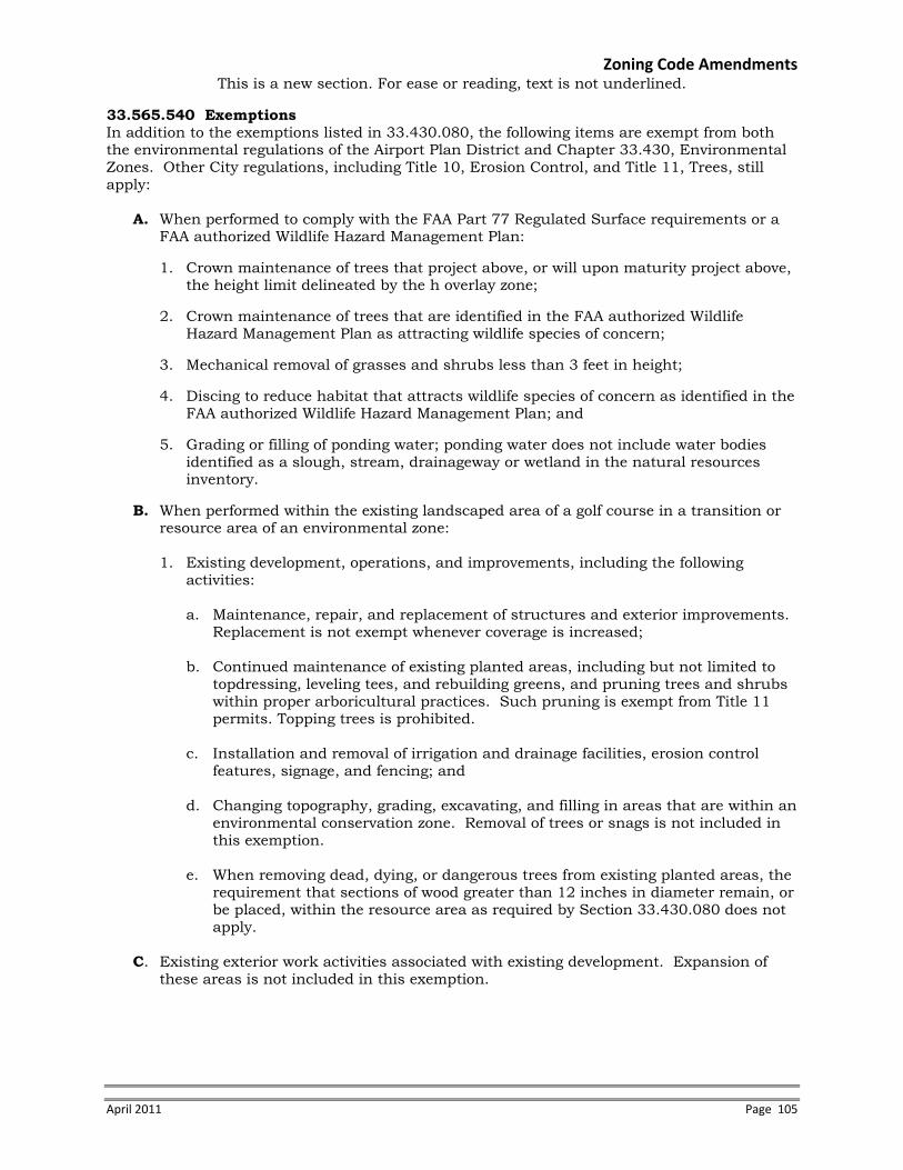
Zoning Code Amendments This is a new section. For ease or reading, text is not underlined.
April 2011 Page 105
33.565.540 Exemptions In addition to the exemptions listed in 33.430.080, the following items are exempt from both the environmental regulations of the Airport Plan District and Chapter 33.430, Environmental Zones. Other City regulations, including Title 10, Erosion Control, and Title 11, Trees, still apply:
A. When performed to comply with the FAA Part 77 Regulated Surface requirements or a
FAA authorized Wildlife Hazard Management Plan: 1. Crown maintenance of trees that project above, or will upon maturity project above,
the height limit delineated by the h overlay zone; 2. Crown maintenance of trees that are identified in the FAA authorized Wildlife
Hazard Management Plan as attracting wildlife species of concern; 3. Mechanical removal of grasses and shrubs less than 3 feet in height; 4. Discing to reduce habitat that attracts wildlife species of concern as identified in the
FAA authorized Wildlife Hazard Management Plan; and 5. Grading or filling of ponding water; ponding water does not include water bodies
identified as a slough, stream, drainageway or wetland in the natural resources inventory.
B. When performed within the existing landscaped area of a golf course in a transition or
resource area of an environmental zone:
1. Existing development, operations, and improvements, including the following activities:
a. Maintenance, repair, and replacement of structures and exterior improvements.
Replacement is not exempt whenever coverage is increased; b. Continued maintenance of existing planted areas, including but not limited to
topdressing, leveling tees, and rebuilding greens, and pruning trees and shrubs within proper arboricultural practices. Such pruning is exempt from Title 11 permits. Topping trees is prohibited.
c. Installation and removal of irrigation and drainage facilities, erosion control
features, signage, and fencing; and d. Changing topography, grading, excavating, and filling in areas that are within an
environmental conservation zone. Removal of trees or snags is not included in this exemption.
e. When removing dead, dying, or dangerous trees from existing planted areas, the
requirement that sections of wood greater than 12 inches in diameter remain, or be placed, within the resource area as required by Section 33.430.080 does not apply.
C. Existing exterior work activities associated with existing development. Expansion of
these areas is not included in this exemption.

Code Commentary
Page 106 Airport Futures Adopted City Land Use Plan
33.565.560 General Development Standards Under specified circumstances, including compliance with FAA requirements, these standards are intended to supersede the standards listed in 33.430.140. 33.565.560.A Tree and snag removal. Trees, particularly tall growing species such as black cottonwood, may mature to a height that intrudes into the Part 77 regulated surfaces as defined by the Federal Aviation Administration. The Part 77 regulated surfaces are required to be clear of structures or other intrusions that would pose a risk to aircraft safety. The intent of this standard to allow the Port of Portland to remove trees that currently, or may in the future, intrude into the Part 77 regulated surfaces and replace those trees with a different species or in a location that in the future will not intrude into the Part 77 regulated surfaces.

Zoning Code Amendments This is a new section. For ease or reading, text is not underlined.
April 2011 Page 107
33.565.550 Development Standards Unless exempted by section 33.565.540, above, or by 33.430.080, the standards of this section and the standards of 33.430 must be met. Compliance with the standards is determined as part of a development or zoning permit application process and processed according to the procedure described in 33.565.600. For proposals that cannot meet the standards, Environmental Review is required as described in Section 33.565.580 or in Sections 33.430.210 through .280 and the applicable approval criteria of 33.430.250 through .280 or 33.565.580. Adjustments to the standards are prohibited. Other City regulations, including Title 10, Erosion Control, and Title 11, Trees, still apply. 33.565.560 General Development Standards
A. Tree and snag removal
1. If the tree or snag, 6 inches or greater in diameter, is removed as part of a resource enhancement project, the requirements of 33.565.570 apply.
2. If the tree or snag, 6 inches or greater in diameter, is removed for either of the
following reasons, then standards 33.565.560.A.3 through 7 must be met instead of 33.430.140.K:
a. the tree or snag currently projects, or the tree will upon maturity project,
above the height limit of the h overlay zone, or b. the tree or snag is identified in the FAA authorized Wildlife Hazard
Management Plan as attracting wildlife species of concern.
3. Each tree or snag, 6 inches or greater in diameter, removed must be replaced as specified in Table 565-1, Tree and Snag Replacement; and
Table 565-1
Tree and Snag Replacement Size of tree or snag to be
removed (inches in diameter)
Option A (no. of trees
to be planted)
Option B (combination of trees and
shrubs)
6 to 12 2 not applicable 13 to 18 3 1 tree and 3 shrubs 19 to 24 5 3 trees and 6 shrubs 25 to 30 7 5 trees and 9 shrubs over 30 10 7 trees and 12 shrubs
4. Replacement trees and shrubs must be native and selected from the Portland Plant
List; 5. Replacement shrubs must be in at least a 2-gallon container or the equivalent in
ball or burlap;

Code Commentary
Page 108 Airport Futures Adopted City Land Use Plan
33.565.560.B. Wildlife exclusions It should be recognized that all possible types of wildlife exclusionary structures cannot be anticipated. The City will defer to the Federal Aviation Administration for approval of appropriate wildlife exclusionary structures for use at the Portland International Airport. For wildlife exclusionary structures or fencing, there is no maximum disturbance area specified. An example of an exclusionary structure is a series of black silt fences that break up an open area and therefore deters a flock of geese from landing. 33.565.560.C. Golf Cart Paths The intent is to allow golf courses to relocated or build new cart paths within the conservation overlay zone. There are no requirements for path configuration or material. Golf courses are allowed additional disturbance area beyond what would otherwise be allowed by 33.430.140.A and Table 430-1. Other city regulations, such at Title 10, Erosion Control, and the Stormwater Management Manual, apply. The revegetation standards listed in 33.565.410 do apply to the relocation or installation of new golf cart paths. The intent is to achieve overall enhancement of natural resources within undeveloped portions of the environmental overlay zones location on golf courses.

Zoning Code Amendments This is a new section. For ease or reading, text is not underlined.
April 2011 Page 109
6. Replacement trees must:
a. Be at least one-half inch in diameter and have a maximum height-at-maturity
that will not project above the height limit of the h overlay zone; and b. Be planted within a transition area or resource area on a property owned by
the applicant; or for which the applicant possess a legal instrument that is approved by the City (such as an easement or deed restriction) sufficient to carry out and ensure success of the mitigation; or can demonstrate legal authority to acquire the site through eminent domain.
7. If the replacement trees are planted within 100 feet of the Columbia Slough main channels or secondary drainageways, the trees must be planted above the Base Floodplain Elevation (BFE), as defined on the Federal Emergency Management Agency Flood Insurance Rate Maps.
B. Wildlife exclusions. Instead of standards listed in 33.430.140, all of the following
standards must be met when installing wildlife exclusionary structures or fencing to comply with the FAA authorized Wildlife Hazard Management Plan within the resources area or transition area of the conservation or protection overlay zone:
1. Trees or snags, 6 inches or greater in diameter, that are removed must be replaced
to meet standards 33.565.560.A.3 through 7, above; and 2. Temporary disturbance areas must be replanted so that the area achieves a 90
percent vegetation cover within one year. Vegetation must be native and selected from the Portland Plant List.
C. Golf cart paths. Instead of the standards listed in 33.430.140, all of the following
standards must be met for new or relocated golf cart paths: 1. The disturbance area must be set back at least 5 feet from the resource area of
any environmental protection zone; 2. The golf cart path is no more than eight feet wide; 3. The disturbance area is no more than 18 feet wide; 4. Trees or snags, 6 inches or greater in diameter, removed must be replaced and
meet standards 33.565.560.A.3 through 7, above;
5. Temporary disturbance areas must be replanted so that the area achieves a 90 percent vegetation cover within one year; and
6. Exterior lights must be spaced at least 25 feet apart. Incandescent lights
exceeding 200 watts, or other light types exceeding the brightness of a 200-watt incandescent light, must be placed so they do not shine directly into the resource area of the protection overlay zone.

Code Commentary
Page 110 Airport Futures Adopted City Land Use Plan
33.565.560.D. Golf course vegetation The predominant herbaceous vegetation within the fairways and greens is non-native. This provision is intended to allow continued use of non-native, non-nuisance herbaceous vegetation within the resource areas of golf courses that are currently landscaped. Herbaceous vegetation that voluntarily grows from the existing seed bank in the soil, or is introduced by wind-transported seed, is not covered under this provision. One exemption is provided for Poa annua, or Kentucky Bluegrass. This grass is present in all golf courses and a common method of reseeding a golf course is to use plugs of grass from existing vegetation. Although golf courses do not intentionally plant Poa annua, an exemption is made for the practice described above. 33.565.560.E. Golf course disturbance. These standards help the golf courses continue with normal operation and maintenance of the course. Specifically, the standards allow limited grading, excavating or fill associated with maintenance of greens, tees, fairways, bunkers (sand traps) and water features, which are not identified in the Middle Columbia Corridor/Airport Natural Resources Inventory as a stream, drainageway or wetland, within the existing landscaped area of the golf course that are also within the protection overlay zone. 33.565.560.F. Vehicle or pedestrian crossings The intent of this standard is to improve hydrology, water quality and wildlife habitat of the specified drainageways in the Middle Columbia Slough Subdistrict. This requirement may be appropriate for other drainageways in the Columbia Slough watershed. 33.565.570 Standards for Resource Enhancement These standards are intended to supplement the standards listed in 33.430.170. For example, excavation and fill are allowed within a water body as part of a bank restoration project. Other local, state and federal regulations do apply. 33.565.570.A Wetland habitat conversion Within the Airport Subdistrict there are natural resource areas that in their current condition have exposed standing open water and herbaceous vegetation which attracts wildlife species of concern. The Port of Portland would like to convert those natural resource areas to a different habitat type that discourages use by wildlife species of concern. During a habitat conversion, the vegetation composition would change; however, there should be a balanced or net improvement in overall wetland functions provided by the resource area.

Zoning Code Amendments This is a new section. For ease or reading, text is not underlined.
April 2011 Page 111
D. Golf course vegetation. References to the Portland Plant List in Chapter 33.430 are superseded by the following: 1. Grasses and forbs planted in the existing landscaped portions of the resource or
transition area on a golf course may be non-native; and 2. Poa annua may be planted to maintain existing landscaped portions of the resource
or transition area on a golf course. E. Golf course disturbance. Instead of standards listed in 33.430.140, any activity that
changes topography or results in grading, excavating, or filling of areas in an environmental protection zone must meet the following standards:
1. The activity is in an existing landscaped area of the golf course; and 2. The activity results in disturbance of less than 10,000 square feet;
F. Vehicle or pedestrian crossings.
1. New or altered vehicle or pedestrian crossings of the Middle Columbia Slough, Whitaker Slough, Buffalo Slough, or Elrod Slough must be by bridge.
2. Exceptions.
a. At locations where BES determines that a water control structure is necessary, the standard of this subsection does not apply.
b. The standard of this subsection does not apply to the addition of guard rails to an existing crossing.
33.565.570 Standards for Resource Enhancement An applicant may choose to meet all of the standards of 33.430.170 or all of the standards of this section. In either case, the applicant must meet the standards of 33.430.170.D through F.
A. Wetland habitat conversion. Within the Airport Subdistrict, conversion from an emergent or herbaceous wetland to a scrub-shrub or forested wetland is allowed if all of the following are met:
1. There may be no excavation, fill, grading or construction activity;
2. The habitat conversion area must be replanted, at a minimum, in accordance with one of the following options:
a. Ten native shrubs for every 100 square feet of area and a native grass and
forb seed mix at a ratio of 20 pounds per acre; or
b. One native tree, three native shrubs and four other native plants for every 100 square feet (trees may be clustered);
3. Trees must have a maximum height at maturity that will not project above the
height limit delineated by the h overlay zone; and
4. Permanent irrigation is not allowed.

Code Commentary
Page 112 Airport Futures Adopted City Land Use Plan
3.565.570.B Forest or woodland habitat conversion Within the Airport Subdistrict there are forested and woodland resource areas dominated by tree species that require continual topping to prevent intrusion into the Part 77 regulated surfaces. Topping of black cottonwood trees, and the re-sprouting that occurs after topping, creates nesting opportunities for wildlife species of concern and degrades the health of the tree making it more prone to disease or breakage. These forested and woodland areas should be converted to a vegetation assemblage dominated by a tree species, such as Oregon Ash, that will not grow to a height that intrudes into the Part 77 regulated surface. During a habitat conversion, the vegetation composition would change; however, there should be a net improvement in overall forest/woodland functions provided by the resource area. 33.565.570.C Bank restoration Bank restoration is part of a package of environmental codes, including 33.430, intended to ensure that the Multnomah County Drainage District #1 and Peninsula Drainage District #2 can appropriately and efficiently provide flood control and manage flow conveyance within the sloughs and drainageways in the Columbia Corridor. Managing the drainageways to federal and state flood regulations, requires on-going work within the environmental overlay zones. Reconfiguring the banks of the Columbia Slough and drainageways is done to improve flow capacity, create additional flood storage, create wetland benches and improve natural resource functions. Generally, this activity is conducted by the Multnomah County Drainage District #1 or Peninsula Drainage District #2, but may be conducted by the City of Portland, U.S. Army Corps of Engineers or other public agencies. In all circumstance, the Multnomah County Drainage District #1, which manages the flow and conveyance in the drainageways in the plan district, must authorize the activity. Staffs believe that these bank restoration activities would be appropriate in Peninsula Drainage District #1 as well.

Zoning Code Amendments This is a new section. For ease or reading, text is not underlined.
April 2011 Page 113
B. Forest or woodland habitat conversion. Within the Airport Subdistrict, forest or woodland conversion to a different native tree association is allowed if all of the following are met:
1. There may be no excavation, fill, grading or construction activity; 2. The habitat conversion area must be replanted, at a minimum, with one native
tree, three native shrubs and four other native plants for every 100 square feet of area (trees may be clustered);
3. The habitat conversion area must be replanted, at a minimum, to meet one of the
following:
a. Generally. One native tree, three native shrubs and four other native plants for every 100 square feet of area (trees may be clustered). Trees must have a maximum height at maturity that will not project above the height limit delineated by the h overlay zone;
b. Exception. If the maximum height of all appropriate tree species would
project above the height limited delineated by the h overlay zone, the habitat conversion area must be replanted with at least 10 native shrubs for every 100 square feet of area and a native grass and forb seed mix at a ratio of 20 pounds per acre;
4. Permanent irrigation is not allowed.
C. Bank restoration. Slough and drainageway banks, which are the area between 12 and 18-inches below the ordinary high water mark and the top of bank, may be re-graded when all of the following standards are met:
1. The activity is conducted or authorized by the Multnomah County Drainage
District #1 or Peninsula Drainage District #2; 2. The final slope above ordinary high water after grading is 33 percent or less (33
percent slope represents a rise to run ratio equal to 1:3); 3. Rock armoring may not be used except surrounding outfalls, inlets, culverts and
bridge crossings, the rock armoring cannot exceed a distance of 5 feet from those features, and must be planted with live stakes of native plant stock, one half inch in diameter. Stakes must be used at a density of 2 to 3 stakes per 9 square feet. If the armoring is located on a levee, live stakes are not required;
4. The placement of large wood on the bank is allowed to improve bank stabilization
if installed above the Base Floodplain Elevation (BFE), as defined on the Federal Emergency Management Agency Flood Insurance Rate Maps;
5. Trees or snags, 6 inches or greater in diameter, that are removed landward from
the new top-of-bank must be replaced and meet standards 33.565.570.A.3 through 7, above; and
6. The area between 12 and 18-inches below the ordinary high water mark and the
new top of bank must be revegetated as specified in Figure 565-2 and Table 565-2, Bank Revegetation.

Code Commentary
Page 114 Airport Futures Adopted City Land Use Plan
Table 565-2 Bank Revegetation Within the Airport Subdistrict, the intent of the bank revegetation planting requirement is to allow the option of not including trees in the planting when the bank restoration is performed in the Airport Subdistrict. This is because, depending on the location of the drainageway, riparian trees may upon maturity intrude into the Part 77 regulated surfaces or may create a wildlife hazard. In those circumstances, it would be appropriate to include only native shrubs, grasses and forbs in the planting.

Zoning Code Amendments This is a new section. For ease or reading, text is not underlined.
April 2011 Page 115
Figure 565-2: Bank Revegetation
Table 565-2 Bank Revegetation
Water Body Zone (See Figure
565-2) Planting Requirements
Zone 1
A mix of native emergent wetland vegetation planted at a rate of 50 plugs of vegetation per 100 square feet of area, ten native shrubs for every 100 square feet of area and a native grass and forb seed mix at a rate of 30 pounds per acre. No trees may be planted in Zone 1.
Sloughs and drainageways; except
on levees
Zone 2
A. Within the Middle Columbia Slough Subdistrict, one native tree, three native shrubs and four other native plants for every 100 square feet of area [trees may be clustered].
B. Within the Airport Subdistrict, Option A or ten native shrubs for every 100 square feet of area and a native grass and forb seed mix at a rate of 20 pounds per acre.
On levees Zone 1 and 2
A native grass and forb seed mix at a rate of 50 pounds per acre or a grass seed mix approved by the US Army Corps of Engineers for use on levees applied at a rate of 50 pounds per acre.

Code Commentary
Page 116 Airport Futures Adopted City Land Use Plan
33.565.580 Special Procedures for Wildlife Hazard Management There is wildlife habitat surrounding the Portland International Airport. Much of habitat attracts wildlife species, such as Western Meadow Lark, that pose little or no risk to aircraft safety. However, if a habitat area attracts wildlife species that do pose a risk to aircraft safety, such as Canada Geese, the habitat may need to be altered to deter that particular species’ use. Activities that are required to implement the Federal Aviation Administration (FAA) authorized Wildlife Hazard Management Plan that do not meet the exemptions or standards of this Plan District or Chapter 33.430 are required to go through environmental review; however, no alternatives analysis is required. This is because activities required for wildlife hazard management cannot occur in different locations and generally cannot have less impact on the resource. Impact analysis and mitigation for impacts are required. Bureau of Environmental Services drainageway modification rules may also apply to wildlife hazard management activities.

Zoning Code Amendments This is a new section. For ease or reading, text is not underlined.
April 2011 Page 117
D. Basking features. Placement of large woody debris or large rocks as basking features for wildlife within the Columbia Slough, Whitaker Slough, Buffalo Slough, Peninsula Canal, drainageways or identified wetlands is allowed when all of the following are met: 1. The activity is conducted or authorized by the Multnomah County Drainage
District #1, Peninsula Drainage District #2 or the City of Portland Bureau of Environmental Services;
2. No native trees are removed; 3. The basking feature is installed above the Base Floodplain Elevation (BFE), as
defined on the Federal Emergency Management Agency Flood Insurance Rate Maps; and
4. Temporary disturbance areas are replanted in accordance with Table 565-2.
33.565.580 Special Procedures for Wildlife Hazard Management These provisions apply to wildlife hazard management activities within environmental overlay zones that are required to implement a Federal Aviation Administration (FAA) authorized Wildlife Hazard Management Plan.
A. In addition to the exemptions and standards listed in Chapter 33.430, if the activity does not meet the exemptions of Sections 33.565.540 or the standards of Sections 33.565.540 through 33.565.570, then environmental review is required. Within the Airport Subdistrict, all activities required to implement an FAA authorized Wildlife Hazard Management Plan within the resource area or transition area of the conservation or protection overlay zones that require environmental review are processed through the Type II procedure.
B. Within the Airport Subdistrict and for activities required to implement an FAA
authorized Wildlife Hazard Management Plan, an alternatives analysis is not required. Specifically, instead of the supplemental narrative requirements of 33.430.230.B, the following is required:
1. Activity Description. Describe the activity and why it is necessary to implement
an FAA authorized Wildlife Hazard Management Plan; 2. Documentation of resources and functional values. Documentation of resources
and functional values is required to determine compliance with the approval criteria. In the case of a violation, documentation of resources and functional values is used to determine the nature and scope of significant detrimental impacts.
a. Identification, by characteristics and quantity, of the resources and their
functional values found on the site;
b. In the case of a violation, determination of the impact of the violation on the resources and functional values.
3. Construction management plan. Identify measures that will be taken during the
activity or remediation to protect the remaining resources and functional values at and near the site and a description of how undisturbed areas will be protected. For example, describe how trees will be protected, erosion controlled, equipment controlled, and the timing of activity; and

Code Commentary
Page 118 Airport Futures Adopted City Land Use Plan

Zoning Code Amendments This is a new section. For ease or reading, text is not underlined.
April 2011 Page 119
3. Mitigation or remediation plan. The purpose of a mitigation or remediation plan is
to compensate for unavoidable significant detrimental impacts that result from the chosen activity or violation as identified in the impact evaluation. A mitigation or remediation plan includes: a. Resources and functional values to be restored, created, or enhanced on the
mitigation or remediation site; b. Documentation of coordination with appropriate local, regional, special
district, state, and federal regulatory agencies; c. Activity timetables; d. Operations and maintenance practices; e. Monitoring and evaluation procedures; f. Remedial actions for unsuccessful mitigation; and g. Information showing compliance with Section 33.248.090, Mitigation and
Restoration Plantings. C. Within the Airport Subdistrict, activities required to implement an FAA authorized
Wildlife Hazard Management Plan are not required to avoid or minimize impacts to identified natural resources and functional values within a resource or transition area of either a protection or conservation overlay zone; mitigation is required. Mitigation for impacts to natural resources and functional values is required to meet only the approval criteria of section 33.430.250.E.3-6 when impacts to natural resources and functional values occur within a resource or transition area of either a protection or conservation overlay zone.

Code Commentary
Page 120 Airport Futures Adopted City Land Use Plan
33.565.600 Purpose These regulations are borrowed directly from 33.430.430 and are included is this chapter for ease of reference.

Zoning Code Amendments This is a new section. For ease or reading, text is not underlined.
April 2011 Page 121
Notice and Review Procedure for Permits within Environmental Overlay Zones
33.565.600 Purpose The purpose of this notice and review procedure is to notify the public of the permit review process for development proposed in areas having identified significant resources and functional values. 33.565.610 When These Regulations Apply These regulations apply when a building permit or development permit application is requested within an environmental overlay zone and is subject to the Development Standards of Section 33.430.110 through .190, 33.430.405.B, or 33.430.405.C, or 33.565.510 through .580. These regulations apply instead of the regulations of 33.430.410 through .430. These regulations do not apply to building permit or development permit applications for development that has been approved through environmental review. 33.565.620 Procedure Applications for building permits or development permits as specified in Section 335.430.420 or 33.565.610 will be processed according to the following procedures:
A. Application. The applicant must submit a site plan with an application for a permit. The site plan must contain all information required by 33.430.130, Permit Application Requirements, and any additional information required for a building permit or development permit review.
B. Notice of an application.
1. Notice on website. Upon receipt of a complete application for a building or development permit, the Director of BDS will post a notice of the application on the BDS website and mail a notice of the request to all recognized organizations within 400 feet of the site. The posted notice of the application will contain at least the following information:
A statement that a building or development permit has been applied for that is
subject to the Development Standards of Section 33.430.110 through .190, 33.430.405.B, 33.430.405.C, or 33.565.510-580.
The legal description and address of the site; A copy of the site plan; The place where information on the matter may be examined and a telephone
number to call; and A statement that copies of information on the matter may be obtained for a fee
equal to the City’s cost for providing the copies. The notice will remain on the website until the permit is issued and administrative decision is made, or until the application is withdrawn.
2. E-mailed notice to recognized neighborhood associations. At the time a notice is
posted on the BDS website, the Director of BDS will e-mail information about the internet posting to all recognized neighborhood associations and neighborhood coalition offices within 400 feet of the site. When an e-mail address is not available, the notice will be mailed to the neighborhood association and coalition office.

Code Commentary
Page 122 Airport Futures Adopted City Land Use Plan

Zoning Code Amendments This is a new section. For ease or reading, text is not underlined.
April 2011 Page 123
C. Posting the site and marking development. The applicant must post notice information on the site and identify disturbance areas as specified below. 1. Posting notice on the site. The applicant must post public notice of the proposed
activity or development following the procedure listed in 33.565.320.C. The posted notice will contain the same information as the notice posted on the internet.
2. Marking proposed development on site. Prior to inspection of the site, the
applicant will mark all trees over six inches diameter to be removed on the site and the building and pavement outlines with high visibility tape. The extent of the disturbance area must be marked with orange construction fencing or similar highly visible material. For corrections to violations, the disturbance area and remediation area to be planted must be identified with high visibility tape or similar high visibility material.
D. Site inspection. A BDS inspector will inspect the site prior to issuance of the permit
and will provide the Director of BDS with one of the following:
1. An inspection report that confirms the accuracy of the site plan and conformance with the applicable development standards; or
2. A check sheet identifying the deficiencies in the plan. Deficiencies must be
corrected before a building permit is approved, or they may be addressed through environmental review as described in Sections 33.430.210 through 33.430.280.
E. Comments. Any interested person may comment on the permit application by writing
and specifically identifying errors or non-compliance with development standards. F. Response to comments. If a comment is received, the Director of BDS will respond in
writing or in a manner suitable to the comment. The response will specifically address each comment that concerns compliance with the development standards of Section 33.430.140 through .190 and 33.565.560 through .580. The Director of BDS will recheck permits for compliance with development standards and approve the permit if compliance is reaffirmed or when identified deficiencies are corrected, and when all applicable standards and regulations of the Zoning Code are met.

Code Commentary
Page 124 Airport Futures Adopted City Land Use Plan
Map 565-1. This map shows the Plan District boundaries and the location of the Southwest Quadrant.

Zoning Code Amendments
April 2011 Page 125

Code Commentary
Page 126 Airport Futures Adopted City Land Use Plan
This map shows the archaeological areas of interest in the plan district.

Zoning Code Amendments
April 2011 Page 127

Code Commentary
Page 128 Airport Futures Adopted City Land Use Plan
33.700.075.A.8. This change indexes to inflation the dollar value of improvements that trigger mailed public notice at the airport.

Zoning Code Amendments
April 2011 Page 129
AMEND CHAPTER 33.700
ADMINISTRATION AND ENFORCEMENT
33.700.075 Automatic Changes to Specified Dollar Thresholds [No change]
A. The following sections are subject to this regulation. Any increase or decrease that is not a multiple of $50 will be rounded to the nearest multiple of $50:
1. through 7 [No change] 8. 33.565.310.B.2 [Renumber 8 through 22 to 9 through 23.]

Code Commentary
Page 130 Airport Futures Adopted City Land Use Plan
33.806 Airport Reviews This is the new Airport Reviews chapter, which includes the Airport Transportation Impact Analysis Review and the Southwest Quadrant Public Services review. 33.806.030 Approval Criteria Prior to construction of any of the above identified mitigation projects the Port shall design the project consistent with City standards and obtain any necessary permits to construct it, or enter into a project specific intergovernmental agreement with the City to ensure its construction. The City and Port acknowledge that many factors related to design, funding, permits, and construction can influence the project delivery schedule. The City and Port agree to work cooperatively and in good faith in an effort to deliver the complete mitigation in an efficient and timely manner. The City and Port acknowledge that changed circumstances or requirements may result in the need to delay project implementation to a more appropriate time. Should the need arise, the City Engineer may authorize the delay of a project, with full concurrence of the Port to some mutually agreed upon time.

Zoning Code Amendments This is a new chapter. For ease of reading, text is not underlined.
April 2011 Page 131
Add new chapter: CHAPTER 33.806
AIRPORT REVIEWS
Sections: Airport Transportation Impact Analysis Review 33.806.010 Purpose 33.806.020 Procedure 33.806.030 Approval Criteria
Southwest Quadrant Public Services Review 33.806.100 Purpose 33.806.110 Procedure 33.806.120 Approval Criteria
Airport Transportation Impact Analysis Review.
33.806.010 Purpose The Airport Transportation Impact Analysis Review ensures that adequate transportation is available to serve the needs of Portland International Airport as it grows.
33.806.020 Procedure Airport Transportation Impact Analysis Reviews are processed through a Type III procedure.
33.806.030 Approval Criteria The proposal will be approved if the review body finds that the applicant has shown that all of the following approval criteria are met:
A. The proposal will fully mitigate the impacts of the additional transportation demand
identified in the Transportation Impact Analysis; and B. All prior City Engineer required mitigation projects have been completed.

Code Commentary
Page 132 Airport Futures Adopted City Land Use Plan
33.806.120.B Southwest Quadrant Public Services Review Approval Criteria This section is intended to result in an analysis of the impacts of proposed development on NE 33rd Drive, and not more broadly to other streets in the plan district.

Zoning Code Amendments This is a new chapter. For ease of reading, text is not underlined.
April 2011 Page 133
Southwest Quadrant Public Services Review
33.806.100 Purpose The Southwest Quadrant Public Services Review ensures that public services are adequate to allow for new development.
33.806.110 Procedure Type Southwest Quadrant Public Services Reviews is processed through a Type III procedure.
33.806.120 Southwest Quadrant Public Services Review Approval Criteria The application for Southwest Quadrant Public Services Review will be approved if the review body finds that the applicant has shown that all of the following approval criteria are met:
A. The proposed use is in conformance with the street designations in the Transportation
Element of the Comprehensive Plan;
B. The transportation system is capable of supporting the proposed use in addition to the existing uses in the area. This evaluation is limited to ensuring that new development meets City requirements for street capacity, level of service or other performance measures; access to arterials; connectivity; transit availability; access restrictions; impacts on pedestrian, bicycle, and transit circulation; and safety for all modes; and
C. Public services for water supply, police and fire protection are capable of serving the
proposed development, and proposed sanitary waste disposal and stormwater disposal systems are acceptable to the Bureau of Environmental Services.

Code Commentary
Page 134 Airport Futures Adopted City Land Use Plan
33.815.200 Aviation And Surface Passenger Terminals Removing conditional use approval criteria for airports, as PDX is now allowed by right within the IG2 zone in the Airport Subdistrict of the plan district.

Zoning Code Amendments
April 2011 Page 135
AMEND CHAPTER 33.815, CONDITIONAL USES
33.815.200 Aviation And Surface Passenger Terminals These approval criteria allow Aviation And Surface Passenger Terminals at locations where their impacts on surrounding land uses, especially residential, are limited. The approval criteria are:
A. Airports.
1. Master plan. A conditional use master plan is required. Facilities that are not
related to the airport within the airport boundaries must be included in the master plan. See Chapter 33.820, Conditional Use Master Plans;
2. Public services.
a. The proposed use is in conformance with the street designations in the Transportation Element of the Comprehensive Plan;
b. The transportation system is capable of supporting the proposed use in
addition to the existing uses in the area. Evaluation factors include street capacity, level of service or other performance measures; access to arterials; connectivity; transit availability; on-street parking impacts; access restrictions; neighborhood impacts; impacts on pedestrian, bicycle, and transit circulation; and safety for all modes; and
c. Public services for water supply, police and fire protection are capable of serving the proposed use, and proposed sanitary waste disposal and stormwater disposal systems are acceptable to the Bureau of Environmental Services.
3. Noise abatement plan and noise impact overlay zone. An airport noise abatement plan and noise impact overlay zone have been developed in order to reduce the impact of aircraft noise on development within the noise impact area surrounding the airport;
4. Natural resources. The master plan must describe and analyze potential
cumulative impacts of development on City-designated natural resources and functional values. This description and analysis must include the following:
a. Description of proposed and possible development within the master plan
boundary; b. Description of all potential cumulative impacts from proposed and possible
development within the master plan boundary on areas in environmental overlay zones within the master plan boundary;
c. Description of all potential cumulative impacts from proposed and possible
development within the master plan boundary on areas that meet all of the following:

Code Commentary
Page 136 Airport Futures Adopted City Land Use Plan

Zoning Code Amendments
April 2011 Page 137
(1) They are outside the master plan boundary; (2) They are in an environmental overlay zone; (3) They are in or abut the Columbia Slough; and (4) They are downstream from the airport.
d. Identification of potential significant detrimental impacts to Citydesignated natural resources and functional values within the areas described in A.4.b and c;
e. Mitigation plan. Description and analysis of how significant detrimental
impacts will be avoided, minimized, or mitigated, as follows: (1) Significant detrimental impacts must be avoided where practicable; (2) Where avoiding significant detrimental impacts is not practicable, the
impact must be minimized, and the impacts mitigated. The mitigation must meet the following: • The mitigation must be within the master plan area, and must
enhance the same kind of resource; • If it is not practicable to mitigate impacts within the master plan
area using the same kind of resource, the mitigation may be outside the master plan area, but must use the same kind of resource;
• If it is not practicable to mitigate impacts using the same kind of resource, a different kind of resource may be used, but the mitigation must be within the master plan area;
• If it is not practicable to mitigate impacts using any kind of resource within the master plan area, the mitigation may be outside the master plan area, and any kind of resource may be used.
(3) The mitigation plan must include identification of types and locations of
proposed mitigation and resource enhancement, a schedule for development, mitigation, and resource enhancement; and a monitoring and reporting plan;
f. An analysis of how all proposed and possible development meets the approval criteria of 33.430.250.A.1.a. through 33.430.250.A.1.e. and 33.430.250.A.3.b., or a description of how those approval criteria will be met through a future process.
5. Benefit. The public benefit of the use outweighs any impacts that cannot be
mitigated.
[Reletter B through D to A through C]

Code Commentary
Page 138 Airport Futures Adopted City Land Use Plan
33.900.010 and 33.910, List of Terms and Definitions. Adding aviation related terms and definitions to 900s.

Zoning Code Amendments
April 2011 Page 139
AMEND CHAPTER 33.900
LIST OF TERMS
33.900.010 List of Terms
Aviation-Related Definitions
• Airside Development • Landside Development • General Aviation • Wildlife Species of Concern
AMEND CHAPTER 33.910 DEFINITIONS
33.910.030 Definitions
Aviation-Related Definitions
• Airside Development. Airside development occurs at the Portland International Airport within the Perimeter Security Fence and the Runway Protection Zone. Examples include runways, taxiways, airfield roadways, aviation approach lighting systems, navigational beacons, associated equipment sheds, and security fencing.
• Landside Development. Landside development occurs at the Portland International
Airport outside the Perimeter Security Fence. This area is comprised of the Passenger Terminal, airport access roadways, parking lots, aircraft maintenance facilities, cargo hangers, maintenance buildings, fire and rescue facilities, and other similar types of development.
• General Aviation. General aviation refers to all flights other than military and
scheduled airline and cargo flights, both private and commercial. Examples include business aviation, private flying, flight training, air ambulance, police aircraft, aerial firefighting, and air charter services.
• Wildlife species of concern. Wildlife species of concern are those species with a large
enough body mass (i.e. raptors, waterfowl, coyote, great blue heron or species with flocking behavior (i.e. European starling, gulls) that can result in a high probability of severe impact with aircraft. The wildlife species of concern list is in the Port of Portland's Wildlife Hazard Management Plan, as authorized by the Federal Aviation Administration.

Code Commentary
Page 140 Airport Futures Adopted City Land Use Plan
33.920.510 Aviation and Surface Passenger Terminals Adding rental car facilities and Basic Utilities (public services such as police, fire and MAX) to the list of allowed accessory uses. These uses are already present at the PDX, and are accessory to the primary use of the site (the airport).

Zoning Code Amendments
April 2011 Page 141
AMEND CHAPTER 33.920
DESCRIPTIONS OF THE USE CATEGORIES
33.920.510 Aviation And Surface Passenger Terminals
A. Characteristics. [No change] B. Accessory uses. Accessory uses include freight handling areas, concessions, offices,
parking, maintenance and fueling facilities, aircraft sales areas, rental car facilities and Basic Utilities.
C. Examples. [No change] D. Exceptions. [No change]

Code Commentary
Page 142 Airport Futures Adopted City Land Use Plan
This map shows the changes to adjacent plan district boundaries.

Zoning Code Amendments
April 2011 Page 143

Code Commentary
Page 144 Airport Futures Adopted City Land Use Plan
This page shows the adopted Comprehensive Plan Map Amendments, changing employment zoning to industrial zoning.

Zoning Code Amendments
April 2011 Page 145

Code Commentary
Page 146 Airport Futures Adopted City Land Use Plan
This page shows the adopted Zoning Map Amendments, changing employment zoning to industrial zoning to be consistent with the amended Comprehensive Plan Map.

Zoning Code Amendments
April 2011 Page 147

Code Commentary
Page 148 Airport Futures Adopted City Land Use Plan
Portland Plant List Introduction. Plant selection and spacing is an especially important component of the Airport Plan District. Collisions between birds and aircraft feet ("bird strikes") are a significant hazard to both aircraft feet and birds in and around Portland International Airport (PDX) due to existing natural features and ecosystems, such as the Columbia Slough. In an effort to reduce this hazard, the approved Airport Plant List provides a selection of plant materials and standards for plant spacing which may be used in the plan district. These plants were selected because they generally do not attract wildlife; they do not provide attractive roosting habitat for species posing a threat to aviation safety, and are generally non-seeding or non-fruiting. Where these standards apply. These standards apply to new development and significant redevelopment within the PDX Plan District - Airport Subdistrict and the Cascade Station/Portland International Center Airport Plan District. These standards do NOT apply in environmental overlay zones or to natural resource restoration/enhancement projects. Background. The City of Portland and the Port of Portland developed a set of landscaping design standards for use at PDX within the specific Plan District subdistricts that address plant species and planting standards for spacing and arrangement of trees and shrubs. The list of trees, shrubs, and groundcover vegetation is comprised of species screened by PDX Wildlife staff for general wildlife attractant features such as fruit, berries, height, density, branching structure, and crown shape. The list was also screened against the City’s Nuisance Plant List to ensure no use of these problem species. The Airport Futures planning process adds a PDX specific list to the Portland Plant List, called the Airport Plant List. The current list is based directly on the Port’s 2009 Wildlife Hazard Management Plan (WHMP). Changes to the Airport Plant List. The Airport Plant List is subject to revision based on future updates to the Port’s WHMP and approval by the Bureau of Planning & Sustainability through administrative rule-making. Approval of plants not on the Airport Plant List may be considered on a case by case basis also. An applicant must submit a request to the Port of Portland in a process that takes 10 business days. A form and instructions for submittal are available on the Port’s website www.portofportland.com. The Port will issue a letter indicating that the plant is consistent with the Wildlife Hazard Management Plan and the applicant will need to include this letter in the permit application to the City. Adding to or removing plants from the Nuisance Plant List must be done through a legislative procedure as provided in Chapter 33.740 of the Zoning Code.

Portland Plant List Amendments
April 2011 Page 149
AMEND PORTLAND PLANT LIST TO INCLUDE AIRPORT PLANT LIST Amending the Airport Plant List The Airport Plant List was amended as follows: The Airport Plant List is subject to revision based on future updates to the Port of Portland’s Wildlife Hazard Management Plan and approval by the Bureau of Planning & Sustainability through administrative rule-making. Approval of plants not on the Airport Plant List may also be considered on a case by case basis. An applicant must submit a request to the Port of Portland in a process that takes 10 business days. A form and instructions for submittal are available on the Port of Portland’s website www.portofportland.com. The Port will issue a letter indicating that the plant is consistent with the Wildlife Hazard Management Plan and the applicant will need to include this letter in the permit application to the City. Adding to or removing plants from the Nuisance Plant List must be done through a legislative procedure as provided in Chapter 33.740 of the Zoning Code.

Portland Plant List Amendments
Page 150 Airport Futures Adopted City Land Use Plan
Airport Plant List
Scientific Name Common Name Type
Max. Height at Maturity (ft)
Max. Spread at Maturity (ft)
Acer freemanii 'Armstrong' Armstrong Red Maple Deciduous 50-70 15 Calocedrus decurrens Incense Cedar Evergreen 75 15 Cedrus deodara 'Aurea' Aurea Deodar Cedar Evergreen 10-25 6-10* Chamaecyparis obtusa 'Gracilis' Slender Hinoki Falsecypress Evergreen 20 6* Cryptomeria japonica 'Elegans' Japanese Plume Cedar Evergreen 30 10 Cryptomeria japonica 'Sekkan Sugi' Golden Japanese Cedar Evergreen 25 10* Cupressocyparis leylandii 'Golconda' Gold Leyland Cypress Evergreen 20 6 Prunus sargentii 'Columnaris' Columnar Sargent Cherry Deciduous 35 15
Pla
nt
at 2
5 ft
on
Cen
ter
Zelkova serrata 'Musashino' Musashino Zelkova Deciduous 45 15 Acer buergeranum Trident Maple Deciduous 25-35 20-30 Acer circinatum Vine Maple Deciduous 10-20 20* Acer ginnala Amur Maple Deciduous 10-20 20* Acer griseum Paperbark Maple Deciduous 20-30 25* Acer palmatum Japanese Maple Deciduous 15-25 10-25* Fagus sylvatica 'Tricolor' Tricolor European Beech Deciduous 20-30* 10-20* Ginko biloba Ginko (males only) Deciduous 50+ 30 Liquidambar styraciflua 'Rotundiloba' Rotundiloba Sweetgum Deciduous 60-70* 20-30* Magnolia x soulangiana Saucer Magnolia Deciduous 15-20 15-25* Malus x 'Spring Snow' Spring Snow Crabapple Deciduous 25-30 15-20 Metasequoia glyptostroboides Dawn Redwood (height restricted) Deciduous 70-100 15-25* Oxydendrum arboreum Sourwood Deciduous 25-60 10-25 Parrotia persica Persian Parrotia Deciduous 40 25 Pinus ponderosa Ponderosa Pine (height restricted) Evergreen 60-100 25-30* Prunus serrulata 'Shirotae' Mt Fuji Cherry Deciduous 12-15 20 Pyrus calleryana 'Cleveland Select' Cleveland Select Flowering Pear Deciduous 30-35* 15-20* Acer ¹ rubrum var. Red Maple Deciduous 60-75 30-50*
Tre
es
Pla
nt
at m
inim
um
40
ft o
n C
ente
r
Carpinus ¹ betulus European Hornbeam Deciduous 40-60 30-40*

Portland Plant List Amendments
April 2011 Page 151
Airport Plant List
Scientific Name Common Name Type
Max. Height at Maturity (ft)
Max. Spread at Maturity (ft)
Fraxinus ¹ americana 'Autumn Purple' Autumn Purple Ash Deciduous 45-60* 35-50* Fraxinus ¹ pennsylvanica Green Ash (seedless varieties only) Deciduous 50 40 Gleditsia ¹ tricanthos var. inermis Thornless Honeylocust Deciduous 30-70 30-40* Platanus x ¹ acerifolia London Planetree (height restricted) Deciduous 70-100 60-75* Quercus ¹ coccinea Scarlet Oak Deciduous 75 45 Tillia ¹ americana American Linden Deciduous 60-80 30-50* Tillia ¹ chordata Littleleaf Linden Deciduous 60-70 25-40* Abelia x grandiflora 'Prostrata' Prostrate Glossy Abelia Evergreen 1.5-2 4-5 Berberis thunbergii var. atropurpurea
'Crimson Pygmy' Crimson Pygmy Japanese Barberry Deciduous 2 3 Berberis thunbergii 'Kobold' Kobold Japanese Barberry Deciduous 2-2.5* 2-2.5* Buxus sempervirens 'Suffruticosa' English Boxwood Evergreen 4-5 2-4* Ceanothus thyrsiflorus Blue Blossom Evergreen 4-12 VariableChamaecyparis obtusa 'Nana Lutea' Nana Lutea Hinoki Falsecypress Evergreen 6 4 Cistus spp. Rockrose species Evergreen Variable VariableClematis armandii Evergreen Clematis Evergreen 20 VariableCorylopsis glabrescens Fragrant Winterhazel Deciduous 8-15 8-15 Cotinus coggygria Common Smoketree Deciduous 10-15 10-15 Daphne spp. Daphne Evergreen 3-4 2-3* Enkianthus campanulatus Redvien Enkianthus Deciduous 6-8 4-6* Erica spp. Heath Evergreen 1-2 1-2* Euonymus alatus 'Compactus' Compact Winged Burning Bush Deciduous 8-10 9-11* Euonymus fortunei Wintercreeper Euonymus Evergreen 1-3 2-4 Forsythia spp. Forsythia Deciduous 8-10 10-12 Hamamelis x intermedia 'Diane' Diane Witchhazel Deciduous 8-12* 10-15* Hydrangea macrophylla Bigleaf Hydrangea var. Deciduous 4-6 4-6 Kerria japonica Japanese Kerria Deciduous 4-8 6-9* Leucothoe fontanesiana Drooping leucothoe Evergreen 3-6 3-6
Sh
rub
s
Nandina domestica 'Gulf Stream' Gulf Stream False Bamboo Evergreen 2.5-3.5 3*

Portland Plant List Amendments
Page 152 Airport Futures Adopted City Land Use Plan
Airport Plant List
Scientific Name Common Name Type
Max. Height at Maturity (ft)
Max. Spread at Maturity (ft)
Potentilla fruitcosa Bush Cinquefoil Deciduous 2-4 2-4 Rhododendron griffithianum 'Jean Marie' Honorable Jean Marie Rhododendron Evergreen 5-6 5-6* Rhododendron macrophyllum Western Rhododendron Evergreen 6-12 Rhododendron spp. P.J.M. P.J.M. Rhododendron Evergreen 3-6 6* Rhus typhina 'Laciniata' Laceleaf Staghorn Sumac Deciduous 10-20 10-20* Rosa gymnocarpa Little Wood Rose Deciduous 6 2-4* Rosa nutkana Nootka Rose Deciduous 3-6 6* Salix purpurea 'Nana' Dwarf Alaskan Blue Willow Deciduous 5 3-5* Spiraea douglasii Douglas Spiraea Deciduous 3-7 3-7 Taxus baccata 'Repandens' Spreading English Yew Evergreen 2-4 12-15 Taxus baccata 'Standishii' Standishii Yew Evergreen 7* 3* Arctostaphylos uva-ursi (cultivars) Kinnikinnick Evergreen .5-1.5 3-6* Genista pilosa Silkyleaf Broom Deciduous 1-1.5 2-3* Hemerocallis hybrid Day Lily Deciduous 1-3 Iberis sempervirens Evergreen Candytuft Evergreen 1-2 3-4* Liriope muscari Lily Turf Evergreen 1-2 .5-1 Mahonia nervosa Dwarf Oregon Grape Evergreen 2 Mahonia repens Creeping Mahonia Evergreen 2 3 Pachysandra terminalis Japanese Spurge Evergreen 1 2 Paxistima canbyi Canby Paxistima Evergreen 1-1.5
Gro
un
dco
vers
Sedum spp. Sedum Deciduous Bromus vulgaris Columbia Brome Calamagrostis x acutifolia 'Overdam' Overdam Feather Reed Grass 2.5-3 1.5-2 Carex morrowii 'Evergold' Evergold Japanese Sedge Carex tumulicola Splitawn Sedge
Gra
sses
an
d
Sed
ges
Danthonia californica California Oatgrass 2 *Indicates measurements are not taken from the related website. (height restricted) refers to specific species being limited in usage to areas outside of height restricted zones.