Embed Size (px)
Citation preview

Chapter II
GEOLOGICAL FRAMEWORK OF THE PRECAMBRIAN ROCKS AND
VINDHYAN SEDIMENT ARIES I N THE INDIAN SHIELD
GENERAL STATEMENT
For understanding the tectonic evolut ion and st ructura l history of Vindhyan
Basin, i t is necessary to have a synoptic view of the geological framev/ork
of the Precambrian rocks in the Indian Shield which formed basement for the
Vindhyan Basin. The Precambrian rocks of Indian Shield can be delineated into
three dist inct geotectonic environments, namely;
1. Archaean Metamorphites
2. Proterozoic Fold Belts
3. Proterozoic Cratonic Basins.
1. ARCHAEAW METAMORPHITES
Meta-sedimentary and meta-igneous rocks subjected to polyphase deformation
and metamorphism occurr ing below the Eparchaean unconformity have been
included into Archaean metamorphi tes. These have been given dif ferent nom3n-
clatures in Indian strat igraphic terminology such as Bhilwara Supergroup in
Northwestern India, Sagrur Group in South India, Bundelkhand Granite and

14
Gneisses in Central India and Iron Ore Group and Older Metamorphites in Singh-
bhum area of eastern Indian Shield (see Auden, 1933; Sarkar, 1972; lyenger,
1976; Murthy and Murthy, 1978). There seems to be wide variations in usage
and terminology of the Archaean in the Indian strat igraphic nomenclature.
The close of the Archaean at 2500 M.a. has been widely accepted (Sarkar,
1972; Murthy and Murthy, 1978; Anon, 1981).
A review of the Pre 2500 M.a. history of the Indian Shield brings out homo
geneity in the pattern of geologic evolut ion. The Archaean formations of Indian
Shield are broadly divisible into four major l i thostrat igraphic units (see Murthy
& Mur thy, 1978) as given in Table-3.
Table - 3
a. Intrusives
b. Green stone Belts
c. Upper Amphibol i te and Lower Granul i te Facies rocks
d. Granul i te Facies rocks.
Granulite Facies Rocks
The granul i te terra in includes charnokites, khondalites, m igmal i l i c gneisses,
cord ier i te , sappharine, kornerupine bearing gneisses, u l t ramaf ic layered anorlho-
sites, etc.
15
The rock of granul i te facies have been recorded f rom the Eastern Ghats, Western
Ghats, Shillong Plateau, Ranchi, Rajasthan, Andhra Pradesh, Tami l Nadu, Grissa,
etc.
Upper Amphibolite and Lower Granulite Facies Rocks
Some high grade metamorphites which were earl ier considered as part of Dharwar
System (Foote, 1886, Smeeth, 1916? Rama Rao,1936) in Southern Indian Shield
and the Araval l i Series in Northwestern Indian Shield (Heron, 1953) are now
recognised as older strat igraphic elements referrable to Sagrur Group in the
Southern Indian Shield and Bhi lwara Supergroup in Rajasthan (see lyenger,
1976). Metasediments, coeval to upper Amphibol i te and lower granulite facies
rocks of Archaeans have been recognised f rom Andhra and Karnataka Cratons
(Rama Krishnan, et a l . , 1976; Radha Krishna and Vasudev, 1977).
Greenstone Beits
The greenstone belts have been recognised f rom Archaean terrains comprising
lower u l t ramaf ics and basic volcanic sequence and an upper clastic sedimentary
group, capped w i th chemogenic iron format ions and cherts. These greenstone
belts have been recognised f rom the Karnataka craton, Andhra Pradesh, Tamil
Nadu, Rajasthan, Bihar-Orissa region, e tc . (Murthy and Murthy, 1978). Geochro-
nologically they have been considered as Archaeans (Sarkar, ^^7'^) Hiit recent
dates tend to place them in younger proterozoic sequence (see Crawford, 1969).
16
Intrusives
Discordant intrusives having diverse l i thologies recorded f rom the Archaean
terrains have been dated Pre 2500 M.a. (see Crawford , 1969).
A review of the above suggest that the Indian Shield during the Archaean under
went granul i te facies metamorphism which resulted in increase in the density
of crustal rocks possibly by addit ion of garnet (see Press, 1973; Hales, Helsiey
Nat ion, 1970; Bi rch, 1970) during the Archaean (Iqbaluddin, 1981).
VHOTEnOZOlC FOLD BELTS
Proterozoic sedimentation took place in the Indian Shield over the Archaean
basement along narrow elongated mobile belts and in large inland basins.
The Proterozoic sediments deposited in the mobile belts exhibit homogeneity
in their geotectonic evolut ion. The basal sequences are characterised by shore
line volcanism fol lowed by f inely laminated rhythmites simulat ing distal flysch
type shales. Towards the top of the sequence occasionally chemogenic environ
ment predominates resulting in the dsposition of chert , carbonates and iron
format ion, etc. (Windely, 1973; Murthy and Murthy, 1978; Mathur, et a l . , in
press).
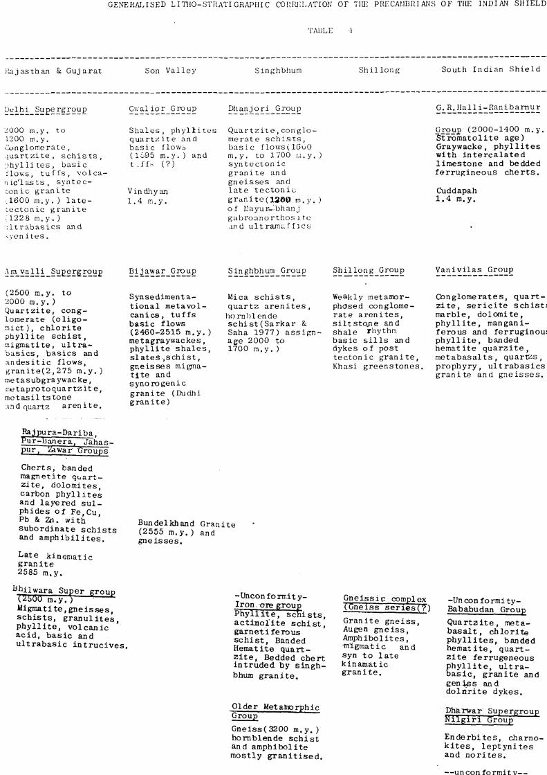
The Proterozoic sedimentation in the Indian Shield is represented by Dharwar

17
in South, Araval l i in the west, Bi jawar and Gwaiior groups in Son valley,^ Singh-
bhum and Dhanjori groups in Singhbhum area, Amagaon Group in Madhya Pradesh
and Shillong Group in Assam Plateau. Table-4 represents the generalized l i tho-
logies and their temporal corre lat ion of the mobile fold belts in the dif ferent
parts of Indian Shield.
RESUME OF VnE-UlNVHVAN GEOLOGV OF INVIAN SHIELV
It w i l l appear f rom the review of the Proterozoic Fold belts that thickness
of about 30 km was deposited in the Proterozoic geosynclines which spatially
const i tute about 25% of the shield area. The Archean crust must have been
eroded to provide elastics for the f i l l i ng of Proterozoic mobile belts of Arava l l i ,
Dharwar, Delh i , Bi jawar, Gwai ior, Dhanjor i , Singhbhum, etc. Thus the crustal
thinning of the Archaean craton (of 4-5 km) would have taken place. These
eroded areas of the Archaean (positive tectonic) topography became the sites
for the proterozoic inland basin of Vindhyan, Cdddapah, Kurnool, Kaladgi,
Bhima, etc. during late Proterozoic t imes. A character ist ic feature of these
basins is that they rest over the basement which is older than 2500 M.a.
EVOLUTION or CHATONIC BASINS VU1UNG PROTEROZOIC TIME
The cralonic basins have variable history through space and l ime . The genesis
of Cralonic basins has remained a subject of debate. Some of the cratonic
basin are thought to be located over the axis of ancient r i f t systems (see McGinls,
GENERAI.ISED LITOO-STHATI GRAPllI C CXDIUUCL ATION OF TIK PRECAMBRIAJJS OF THE INDIAN SHIELD
TA13LE
:>uijasthan Si Gujarat Son Val ley Singhbhum S h i l l o n g South Indian Sh ie ld Madhya Pradesh and Maharashtra
Uelhi Supergroup Gua l io r Group Dhanjori GrouiD G. R . H a l l i - R a n i b a m u r Amgaon Group
2 000 m.y. to 1200 m.y. Conglomerate, l u a r t z i t e , s c h i s t s , o h y l l i t e s , b a s i c :lov,s, t u f f s , vo 1 call Ic'l as t s , s y n t e c -ronic g r a n i t e aeOO m.y. ) l a t e -l e c t o n i c g r a n i t e ,1228 m . y . ) : l t r a b a s i c s and sven i t e s .
S h a l e s , p h y l l i t e s q u a r t ^ i t e and b a s i c flowi (1695 m . y . ) and t.ff;^ (?)
Vindhy an 1.4 m.y.
Q u a r t z i t e , c o n g l o -merato s c h i s t s , b a s i c flows(16u0 m.y. to 1700 w . y . ) syn t ec ton ic g r a n i t e and g n e i s s e s and l a t e t e c t o n i c g r a n i t e ( 1 2 0 0 m . y . ) of Uayur-'bhanj gabroanor thos i te and ultrami-f f i c s
Group (2000-1400 m.y , ) "Stlromatoli te age) Graywacke, p h y l l i t e s wi th i n t e r c a l a t e d l imes tone and bedded f e r r u g i n e o u s c h e r t s .
Cuddapah 1.4 m.y.
(1730 m.y. t c 1444 m.y . ) Quartz s e r i c i t e sch i s t f e l s p a t h i c q u a r t z i t e garnet e p i d o t e q u a r t z i t e h o m b l e n d e - b i o t i t e -q u a r t z i t e , hornblende s c h i s t and" amph ibo l i t e .
A r a v a l l i Sugergroug Bijawar Group Singhbhum Group Sh i l l ong Group V a n i v i l a s Group
(2500 m.y. to 2000 m . y . ) Q u a r t z i t e , conglomerate ( o l i g o -n i c t ) , c h l o r i t e p h y l l i t e s c h i s t , rp.igmatite, u l t r a -b a s i c s , b a s i c s and a n d e s i t i c f lows, g r a n i t e ( 2 , 2 7 5 m.y. ) metasubgraywacke, iTietapro to q u a r t z i t e , m e t a s i l t s t o n e ;ind quartz a r e n i t e .
Synsediraenta-t i o n a l me tavo l -c a n i c s , t u f f s b a s i c flows (2460-2515 m . y . ) metagraywackes, p h y l l i t e s h a l e s , s l a t e s , s c h i s t , g n e i s s e s migma-t l t e and synoro genie g r a n i t e (Dudhi g r a n i t e )
Mica s c h i s t s , q u a r t z a r e n i t e s ,
hornbl ende s c h i s t (Sa rka r S: Saha 1977) a s s i g n -age 2000 to 1700 m . y . )
Weekly metamorphosed conglomer a t e a r e n i t e s , s i l t s t o / i e and sha le rhythm bas i c s i l l s and dykes of post t e c t o n i c g r a n i t e , Khasi g r e e n s t o n e s .
Conglomerates , q u a r t z i t e , s e r i c i t e s c h i s t s , marble , d o l o m i t e , p h y l l i t e , mangani-f e rous and f e r r u g i n o u s p h y l l i t e , banded hema t i t e q u a r z i t e , m e t a b a s a l t s , quar tzs , p rophyry , u l t r a b a s i c s , g r a n i t e and g n e i s s e s .
Rajpura-Dar iba . I ^ r - b a n e r a . J a h a s -pur , Zdwar Groups'
Cher t s , banded magne t i t e q u a r t z i t e , do lomi t e s , carbon p h y l l i t e s and l aye red s u l ph ides of Fe.Cu, Pb & 2ii. wi th s u b o r d i n a t e s c h i s t s and a m p h i b i l l t e s .
Late k inemat i c g r a n i t e 2585 m.y.
^hj iwara Super group
U i g m a t i t e , g n e i s s e s , s c h i s t s , g r a n u l i t e s , p h y l l i t e , v o l c a n i c a c i d , b a s i c and u l t r a b a s i c i n t r u c i v e s .
Bundelkhand Gran i te (2555 m.y . ) and g n e i s s e s .
-Unconformity-I ron .ore group P h y l l i t e , s c h i s t s , a c t i n o l i t e s c h i s t , g a r n e t i f e r o u s s c h i s t , Banded Hematite q u a r t z i t e . Bedded che r t i n t r u d e d by s i n g h bhum g r a n i t e .
Older Metatnorphlc Group
Gneiss(3200 m . y . ) hornblende s c h i s t and amphibo l i t e most ly g r a n i t i s e d .
G n e i s s i c complex (Gneiss seriesT?")
Gran i t e g n e i s s , Augen g n e i s s , Amphibol i tes , •migmatic and syn t o l a t e k i n a m a t i c g r a n i t e .
-Uncon fo rm! ty -Bababudan Group
Q u a r t z i t e , meta-b a s a l t , c h l o r i t e p h y l l i t e s , banded h e m a t i t e , q u a r t z i t e fe r rugeneous p h y l l i t e , u l t r a -b a s i c , g r a n i t e and g e n i s s and d o l r i r i t e dykes .
ph&TWar Supergroup K i l g i r i Group
E n d e r b i t e s , charno-k i t e s , l e p t y n i t e s and n o r i t e s .
—un con f o rmit y—
(Mercara Group) tJagrur Group b i e t i t e - k y a n i t e s c h i s t , g r a n i t e g h e i s s
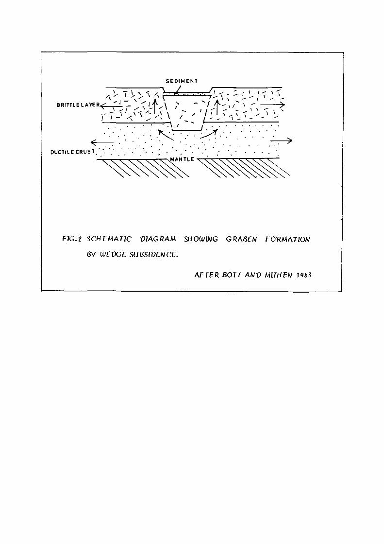
197D; Haxby, et a l . , 1976; Burke, 1976; Da lon j i , 1981; De R i to , el a l . , 1983).
However, Bott and Mithen (1983) were of the opinion that the plate boundary
forces may have an important role in r i f t ing in earl ier t imes, part icular ly at
periods in geological t ime when subduction was reported on opposite side of
large continents such as Pangea during Mesozoic t ime result ing in tensile f ie ld
in the continental crust. On smaller scale local tensile stresses associated
w i th bands in t ransform faults may fo rm 'Pul l -apar t ' basins by wedge subsidence
or by stretching. (Fig. 2).
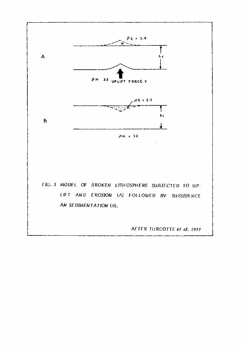
Turcot te , et a l . (1977) have advocated a model of broken lithosphere subjected
to ver t ica l upl i f t and subsequent erosion for the cratonic basins (Fig. 3).
Proterozoic cratonic basins in the shield areas of the world does not conf i rm
to the classic concepts of r i f t ing or the l i thospheric f rac tur ing . In the context
of present study, a petro-tectonic model of l i thospheric arching due to astheno-
spheric diaperism (during the Archaean) fo l lowed by l i thospheric thinning due
to erosion (in Lower Proterozoic) and subsidence in response to phase trans
format ion (in Upper Proterozoic) has been advocated as a possible mechanism
for the evolution of Proterozoic Cratonic basins (see Iqbaluddin, 1981).
EUOLUiTlON OF UWVHVAN BASIN IN THE INVIAN SHIELV
The development of Proterozoic Cratonic Basin has been discussed by Iqbaluddin
(1981). He records that true morphogeny as seen in younger geotectonic cycles
was lacking during the Precambrian geological cycles. It was rudimentary and
SEDIMENT
^ ^^ ^ ^ " ^ / /
DUCTILE CRUST. . . . ' . • • . vMANTLE
T'lG.l SCHEMATIC VIAGUAM SHOWZWG GRA8EW FOUMATION
BV {JJEVGE SUBSWENCE.
AFTER 80TT AhJV MTHEN 79«3
r
Pc •- 2.8
A h
' ' " ^'^ UPLIFT FORCE V
/JS = 2-2
r c
r l>c
B 4
/>m = 3-3
FIG. 3 MODEL OF BTIOKBN LITHOSPHERE SUBJECTEO TO UP-
LZFT ANV EROSZOA/ (A) FOLLOWED
AA/ SEVmENTATlON (S).
By SUBSWENCE
AFTER TURCOTTE ef at. 1977
19
relief was generated through diaperism of asthenospheric/upper mantle mater ia l
into the crust. In the Indian Shield positive tectonic topography was generated
during the Archaen (3000 M.a.). Perhaps this was control led by the asthenospheric
diaperism, which led to lithospheric arching, resulting in rudimentary morphogeny
in areas which now f rom the site of the Vindhyan Basin.
Diaperism of the higher density asthenospheric, mater ia l into l ighter density
l ithosphere, cal l for explanation. Recent work on gravi tat ional instabi l i ty of
the lithosphere (Hales, Helsley and Nat ion, 1970; : Bi rch, 1970; Press, 1973 )
has led to the concept the lithosphere becomes more dense than asthenosphere
due to density inversion. The density inversion is possibly achieved by appearance
of garnet in l ithosphere. The development of garnet in the lithosphere increases
its density; this density inversion of the lithosphere ini t iates diaperic upward
raise of asthenosphere. The loci of the asthenospheric diaperism are points/zones
where the lithosphere is weakest. Such zones are preferably below the crustal
f ractures.
In the Indian Shield density inversion of the lithosphere took place during the
Archaean when granuli te belts of Sagrur Group in southern part and Sanda
Mata Complex in northwestern part of Indian Shield were formed. These are
characterised by addit ion of garnet in lithosphere around 3000 M.a. The study
of the Precambrian supracrustals in northwestern part of the Indian Shield
by Murthy (in press) has revealed that the rel ief was generated in the craton
around around (2500 M.a.). Roughly coinciding w i th the emplacement of Berach

20
Granite in Rajasthan and coeval granites in Bundelkhand and South India. Peniaps
this was control led by asthenospheric diaperism which led to lithospheric arching,
resulting in development of posit ive tectonic topography in area which now
form the site of the Vindhyan Basin in Indian Shield.
The posit ive tectonic topography generated during the Archaean supplied al lo
genic elastics to the Proterozoic geosynclines (Araval l i , Delhi and Bijawars)
f rom (2500 M.a.) onwards. This erosion led to thinning of lithosphere along
crestal zone of the lithospheric arch (Fig. 4).
The disperism has been cycl ic and episodic in earth's history. The cooling of
the obducted asthenosphere and d i f ferent ia t ion led to density equi l ibr ium (between
asthenosphere and lithosphere) and consequently to subsidence of asthenospheric
diaper at density nul l .
The subsidence of the l ithospheric arch resulted in the development of negative
tectonic topography in the cratonic regime, which becomes site of the Vindhyan
Basin. The depth of the basin was in i t ia l ly euqal to the eroded thickness of
the lithosphere. If H represents the original thickness of the lithosphere and
h is the depth of erosion, then the depth of the basin wi l l he 'h ' and lithospheric
thickness in the basin zone w i l l be H-h. Thus below the cratonic basins l i tho
spheric thinning has taken place in the Indian Shield (see Iqbaluddin, 1981).

K.
1- ( f i o i p h e i e
Aithenoiphete
Ai^henoipftetic diopet due to dznuty invtiuon betcveen ttthoiphete a«d A&theno&p/tete, fatougfct about be/ development o|S ^awiet oi lltho!tph^^e., exogenicaUy manHzUed __ — — ~. _aA gtaiiui<te be/ti.
Eiowon 0 the Uthoiphzuc atch and dzpoution oi thz ctiifogcnci in pioteto-zic Geo4i/nct</ie9itom 2500 Wui. onuiatdi.
CRATOWIC 8AS/W
Coo/ing and d^^etentiot^'on o A&theno&piiefic diaptu Lot to dztiuty zqaiU-bivim and conizqent iubwdcwce leiuftwg « negative te-ctonic topoguLphy within the C tot on.
FIG. 4 : SCHEMAT/C MOUEL FOK THE GCOTCCTOA/IC EVOLUTION OF CKATONIC 8ASIW5.
21
VINDHYAN BASIN
Vindhyan Basin covering an area of about 70,000 sq. I<m occurs as an arcuate
basin (Fig. 1). The l imi ts of Vindhyan Basin have been defined by major crustai
grains of Son-Narmada lineament in the south and Great Boundary Fault in
the Nor th . The western margin of the basin has been obscured by the cover
of Deccan Trap volcanics. The Bundelkhand massif occurring as Premonitory,
l imi ts the Vindhyan sedimentation in the east.
The Vindhyan sedimentation has been studied in detai l in the Son val ley, U.P.;
Narbada val ley, M.P. and Chambal val ley, Rajasthan» The cont inuity of Vindhyan
sedimentaries f rom Son valley in U.P. to Chambal valley in Rajasthan has
been punctuated by younger covers of Deccan volcanics and Quaternary Al luv ium,
but there is growing evidence that Vindhyans extend as a continuous sequence
f rom Sasaram in the east through Son valley in U.P. and M.P. to Rajasthan
in the west where the sedimentary sequence abuts against Bhi lwara metamorphics
of Archaean age. The boundary between the Proterozoic terrigeneous elastics
and the Archaean metamorphites has been mapped as tectonic element designated
as Great Boundary Fault of Rajputana (see Heron^ 1917, 1922; Pasco e, 1968;
Prasad, 1977; Iqbaluddin, et a l . , 1978).
STRATIGRAPHY OF VINDHYAN SUPERGROUP - REGIONAL PERSPECTIVE
The supracrustals comprising terrigenous elastics of Vindhyachal region of

22
Central India were assigned to the Vindhyan System by Oldham (1856). The
stratigraphy of these Proterozoic sedimentaries was studied in the Son valley
of U.P. which forms type area of the Vindhyan system (see Mal le t , 1869; Coulson,
1927; Heron, 1922; 1936; Auden, 1933; Prasad, 1975). Heron (1936) extended
the nomenclature of the type area to the Vindhyans of Rajasthan. Table 2
presents the l i thostrat igraphy of Vindhyan Supergroup as proposed for the type
area of Son valley and Rajasthan (Auden, 1933; Heron, 1936; Prasad, 1975).
In Rahasthan the Vindhyan Supergroup comprises a repet i t ive sequence of cal
careous, arenaceous and argil laceous suite of rocks which are 2,900 m thick
(see, Prasad, 1981). It is broadly classif ied into lower and upper Vindhyans.
Semri Group const i tute the lower Vindhyan while Kaimur, Rewa and Bhander
groups have been included under upper Vindhyan (see Mal le t , 1869; Coulson,
1927; Auden, 1933; Ramasamy and Sogani, 1978; Prasad, 1981; Banerjee and
Maharaja Singh, 1981). Prasad (1975) has reclassified the lower Vindhyans of
Rajasthan into Satola, Sand, Lasrawan and Khorip groups. Table 5 presents
the l i thostrat igraphy of the Vindhyan Supergroup in the study area.
ENVIRONMENT OF V INDHYAN SEDIMENTATION
The Vindhyan sedimentaries were deposited in an al ternat ing f luvio-deltaic
marine environment (Coulson, 1927; Auden, 1933; Banerjee, 1964; Ramasamy
and Sogani, 1978; Prasad, 1981). Heron, (1936); Prasad and Ramasamy, (1980);
Prasad, (1981); Banerjee and Maharaja Singh, (1981); and Mathur, (1981) have
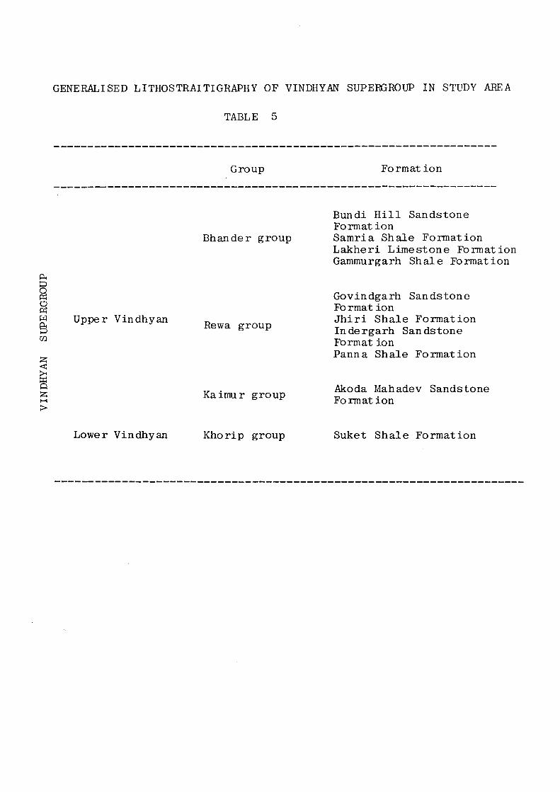
GENERALISED LITHOSTRAITIGRAPHY OF VINDHYAN SUPERGROUP IN STUDY AREA
TABLE 5
Group F o r m a t i o n
§ o w & CO
Bhander group
Upper Vindhyan Rewa group
Bundi Hill Sandstone Formation Samria Shale Fonnation Lakher i Limestone Formation Gammurgarh Shale Formation
Govindgarh Sandstone Fo rmat ion J h i r i Shale Formation Indergarh Sandstone Format ion Panna Shale Formation
Q Kaimur group Akoda Mahadev Sandstone
Formation
Lower Vindhyan Khorip group Suket Shale Formation

23
suggested stable shelf environemni and local restr ic ted condit ions during Vindhyan
sedimentat ion. Singh (1980) has suggested t ida l environemnt for the Bijaigarh
shale of Vindhyans in Son val ley.
STRUCTIXHAL ANV TECTONIC FT^AMEWOTJK OF THE VINVH^AN BASIN
Structural ly the Vindhyan rocks are characterised by peribasinal deformation
w i th central part exhibit ing l i t t l e or no deformat ion. The basin exhibit folding
and steep dips towards the peripheral region in Son val ley, U.P.; Rajasthan
and Madhya Pradesh (see Choubey, 1971; Iqbaluddin and Mughni, 1976; Srivastava
and Iqbaluddin, 1981; Iqbaluddin, et a l . , 1978).
In the axial zone of the basin tensile stress regime prevailed during the structural
evolution of Vindhyan Supergroup. The stress is manifested as tensile fractures
which are ubiquitous and morphotectonical ly expressed as microlineaments
(see Ramasamy, 1985).
The tectonic framework of Vindhyan Basin has been control led by four major
crustal grains which have been mantle lapping endogenic f ractures. For the
purpose of description these have been designated as Son-Narbada lineament,
Asmara l ineament, Jhalawar lineament and Great Boundary Faul t . Their exogenic
expression has been discussed in br ief .

24
MAJOR LINEAMENTS
The structural fabric of Vindhyan basin is morphotectonical ly control led by
four l ineaments (see Ramasamy, 1985) namely,
1 . Son-Narbada Lineament
2. Asmara Lineament
3. Jhalawar Lineament
4. Great Boundary Fault
Son-Narbada Lineament
The southern most boundary of Vindhyan basin is characterised by a rect i l inear
lineament known as Son-Narmada Lineament. This ENE-WSW trending lineament
can be delineated into three major sectors viz-, Narmada, Central and Son
Sectors (see Iqbaluddin, 1976). The exogenic expressians of this endogenic
grain can be summarised as fol lows.
The Son-Narmada Lineament which brought the Vindhyan sedimentaries against
the pre-Vindhyan meta-sedimenls in south is characterised by Peribasinal de
format ion. The folds developed in the area show paral lel ism w i th ENE-WSW
trend of this l ineament. The folds exhibit progressive t ightening f rom centre
to the periphery of the basin. Intense and in t r icate shearing and fault ing is
noticed at Hirapur and a k i lometer NE of B i t l i in Narsinghpur (see Choubey,
1971) in the Vindhyans along Son-Narmada Lineament. Presence of Jungel
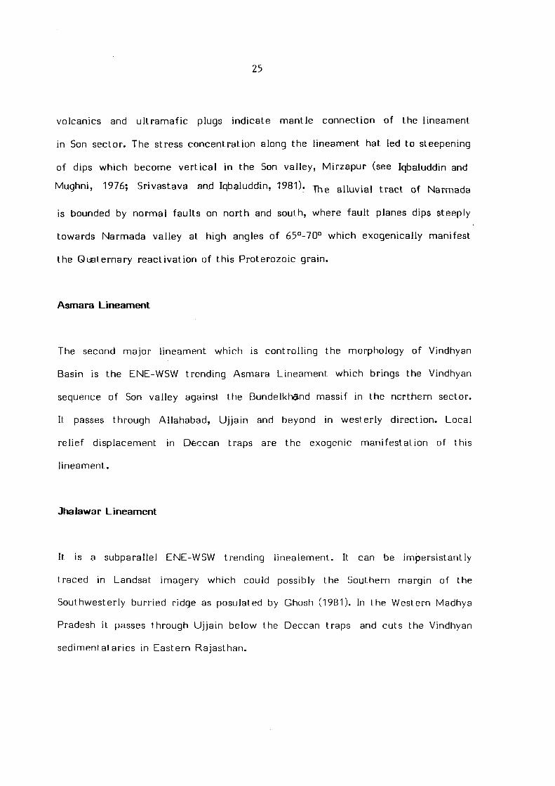
25
volcanics and u l t ramaf ic plugs indicate mantle connection of the lineament
in Son sector. The stress concentrat ion along the lineament hat led to steepening
of dips which become ver t ica l in the Son valley, Mirzapur (see Iqbaluddin and
Mughni, 1976; Srivastava and Iqbaluddin, 1981). j^^ al luvial t ract of Narmada
is bounded by normal faul ts on north and south, w/here fault planes dips steeply
tow/ards Narmada valley at high angles of 65°-70° v\^hich exogenically manifest
the Quaternary react ivat ion of this Proterozoic grain.
Asmara Lineament
The second major lineament which is control l ing the morphology of Vindhyan
Basin is the ENE-WSW trending Asmara Lineament which brings the Vindhyan
sequence of Son valley against the BundelkhSnd massif in the northern sector.
It passes through Allahabad, Uj ja in and beyond in westerly d i rect ion. Local
rel ief displacement in Deccan traps are the exogenic manifestat ion of this
l ineament.
Jhalawar Lineament
It is a subparallel ENE-WSW trending l inealement. It can be imJDersistantly
traced in Landsat imagery which could possibly the Southern margin of the
Southwesterly hurried ridge as posulated by Ghosh (1981). In the Western Madhya
Pradesh it passes through Uj jain below the Deccan traps and cuts the Vindhyan
sedimentataries in Eastern Rajaslhan.
26
Great Boundary Fault
The northwestern margin of Vindhyan Basin is characterised by a major fault
extending f rom Chit torgarh in Nor th to Machilpur in South, for over a distance
of about 400 km in Eastnortheast-Westsouthwest d i rect ion. This faul t is popularly
known as Great Boundary Fault of Rajasthan (see Heron, 1917; Prasad, 975,
1977; Iqbaluddin, et a l . , 1978).
In Rajasthan the Northern l im i t of the Vindhyan Basin is morphotectonical ly
expressed as Great Boundary Faul t . Its exogenic manifestations are intense
f ractur ing along the fault plane, development of slickensides and fault breccia,
myloni t isat ion, ferruginisation and dislocation along f ractures. The dip of the
faul t plane varies f rom moderate to steep.
The Great Boundary Fault was earl ier considered as a single fau l t . According
to recent work, its str ike cont inui ty is punctuated by several le f t lateral and
r ight lateral wrench faults (see Iqbaluddin, et a l . , 1978). There are variable
estimates for the throw of the Great Boundary Faul t . Coulson (1927) and Heron
(1936) have postulated a throw of about 1500 m, while Prasad and Sharma (1977)
worked out a throw of about 500 m, considering the thinning of formations
towards basin margins and uneveness of basin f loor .