Embed Size (px)
Citation preview
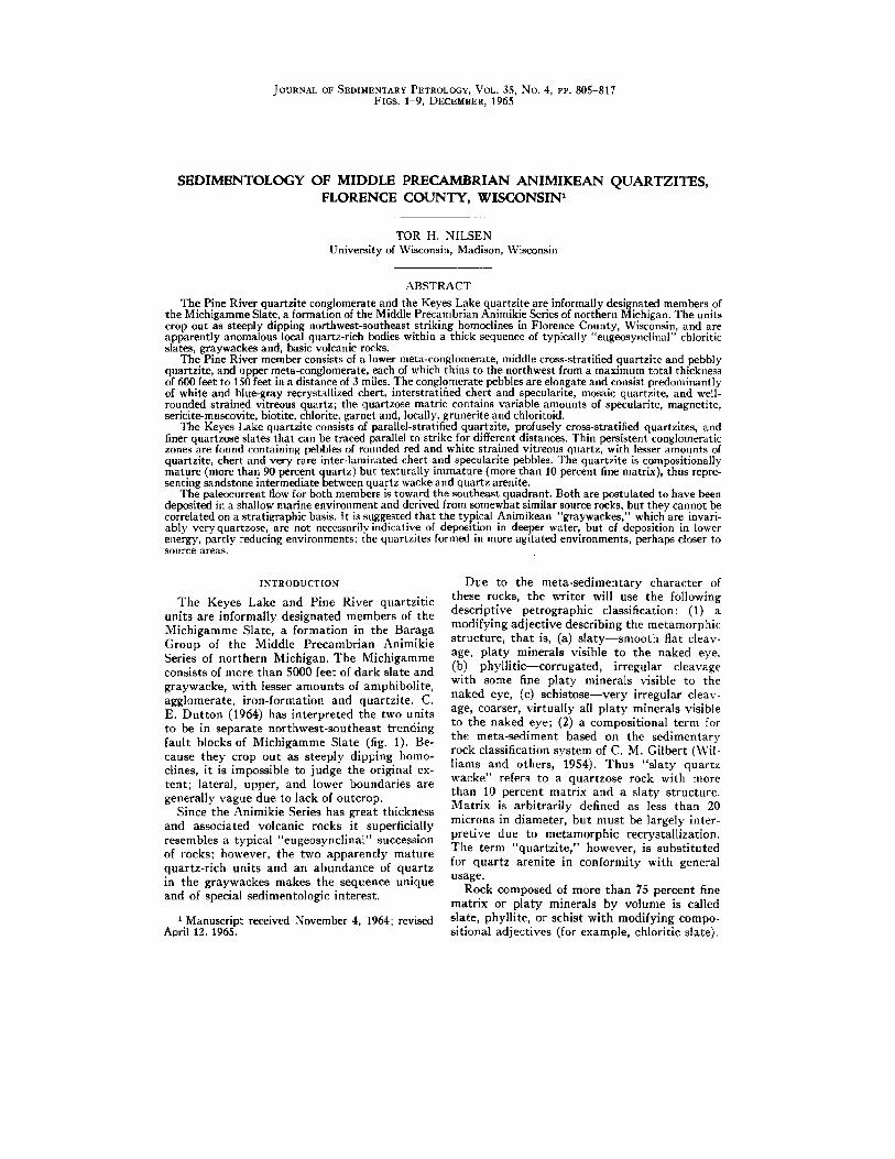
JOURNAL OF SEDIMENTARY PETROLOGY, VOL. 35, No. 4, PP. 805-817 FIGS. 1-9, DECEMBER, 1965
S E D I M E N T O L O G Y O F M I D D L E P R E C A M B R I A N A N I M I K E A N QUARTZITES, F L O R E N C E C O U N T Y , W I S C O N S I N 1
TOR H. NILSEN University of Wisconsin, Madison, Wisconsin
ABSTRACT
The Pine River quartzite conglomerate and the Keyes Lake quartzite are informally designated members of the Michigamme Slate, a formation of the Middle Precambrian Animikie Series of northern Michigan. The units crop out as steeply dipping northwest-southeast striking homoclines in Florence County, Wisconsin, and are apparently anomalous local quartz-rich bodies within a thick sequence of typically "eugeosynclinal" chloritic slates, graywackes and, basic volcanic rocks.
The Pine River member consists of a lower morn-conglomerate, middle cross-stratified quartzite and pebbly quartzite, and upper recta-conglomerate, each of which thins to the northwest from a maximum total thickness of 600 feet to 150 feet in a distance of 3 miles. The conglomerate pebbles are elongate and consist predominantly of white and blue-gray reerystallized chert, interstratified chert and specularite, mosaic quartzite, and well- rounded strained vitreous quartz; the quartzose matric contains variable amounts of specularite, magnetite, sericite-muscovite, biotite, chlorite, garnet and, locally, grunerite and chloritoid.
The Keyes Lake quartzite consists of parallel-stratified quartzite, profusely cross-stratified quartzites, and finer quartzose slates that can be traced parallel to strike for different distances. Thin persistent conglomeratic zones are found containing pebbles of rounded red and white strained vitreous quartz, with lesser amounts of quartzite, chert and very rare inter-laminated chert and specularlte pebbles. The quartzite is compositlonally mature (more than 90 percent quartz) but texturally immature (more than 10 percent fine matrix), thus repre- senting sandstone intermediate between quartz wacke and quartz arenite.
The paleoeurrent flow for both members is toward the southeast quadrant. Both are postulated to have been deposited in a shallow marine environment and derived from somewhat similar source rocks, but they cannot be correlated on a stratigraphic basis, tt is suggested that the typical Animikean "graywaekes," which are invari- ably very quartzose, are not necessarily indicative of deposition in deeper water, but of deposition in lower energy, partly reducing environments;/he quartzites formed in more agitated environments, perhaps closer to source areas.
INTRODUCTION
The Keyes Lake and Pine River quartzit ic units are informally designated members of the Michigamme Slate, a formation in the Baraga Group of the Middle Precambrian Animikie Series of northern Michigan, The Michigamme consists of more than 5000 feet of dark slate and graywacke, with lesser amounts of amphibolite, agglomerate, iron-formation and quartzite. C. E. Dut ton (1964) has interpreted the two units to be in separate northwest-southeast trending fault blocks of Michigamme Slate (fig. 1). Be- cause they crop out as steeply dipping homo- clines, it is impossible to judge the original ex- tent; lateral, upper, and lower boundaries are generally vague due to lack of outcrop.
Since the Animikie Series has great thickness and associated volcanic rocks it superficially resembles a typical "eugeosynclinal" succession of rocks; however, the two apparently mature quartz-rich units and an abundance of quartz in the graywackes makes the sequence unique and of special sedimentologic interest.
1 Manuscript received November 4, 1964; revised April 12, 1965.
Due to the meta-sedimentary character of these rocks, the writer will use the following descriptive petrographic classification: (1) a modifying adjective describing the metamorphic structure, that is, (a) s la ty- -smooth flat cleav- age, platy minerals visible to the naked eye, (b) phylli t ic--corrugated, irregular cleavage with some fine platy minerals visible to the naked eye, (c) schistose--very irregular cleav- age, coarser, virtually all platy minerals visible to the naked eye; (2) a compositional term for the recta-sediment based on the sedimentary rock classification system of C. M. Gilbert (Wil- liams and others, 1954). Thus "slaty quartz wacke" refers to a quartzose rock with more than 10 percent matrix and a slaty structure. Matrix is arbitrarily defined as less than 20 microns in diameter, but must be largely inter- pretive due to metamorphic recrystallization. The term "quartzi te ," however, is substituted for quartz arenite in conformity with general usage.
Rock composed of more than 75 percent fine matrix or platy minerals by volume is called slate, phyllite, or schist with modifying compo- sitional adjectives (for example, chloritic slate).

806 TOR H. N I L S E N
O.
LJ¢ f
AREA
i ~ WISCONSIN
Joas|m 93
Geology fro M ' ~ ere'live investigations / by U. S. Geological Survey~__L~
! Michigoll Geological Lace Lake Survey end Wisconsin Sea.on/~" Geological and Not- Lake urol History Survey
Patten
COMMOIW/EAI.TH
¥ Y - ¥
V
hi m_ 8:
Pine River Reservoir
%
Fie. 1.--Location of area and general geology.
For rocks with coarser than sand-size clasts, those with greater than 75 percent sand-size or finer matrix are termed "pebbly," with a second term describing the matrix composition (for example, pebbly quartzite); if less than 75 per- cent matrix, the rock is termed "conglomerate," with a prefix denoting the matrix composition (for example, quartzite conglomerate). Also, the
coarser-grained rocks can be prefixed by a structural modifier, if prominent structure is present (for example, phyllitic specularitic quartzite conglomerate). The composition of the pebbles in these rocks is a special problem and will be discussed later.
The terms "foliation" or "falSe" are reserved as general terms for parallel fabrics that are

M I D D L E PRECA MBRIA N A N I M I K E A N Q U A R T Z I T E S 807
visible in thin section and are of metamorphic origin, generally being restricted in these rocks to parallel alignment of flattened quartz grains and dimensional orientation of platy and linear minerals.
In the paleocurrent analyses, the means of current directions from cross-strata restorations were determined and 95 percent confidence limits established using Dennison's graphical method (1963). Regional geology indicates that the homoclines have not been rotated about an axis perpendicular to the earth's surface.
PINE RIVER QUARTZITE CONGLOMERATE
Setting
The Pine River (formerly known as "Break- water") quartzite conglomerate consists of a lower conglomerate, middle cross-stratified quartzite and pebbly quartzite, and an upper conglomerate. Each sub-unit thins to the north- west, with total thickness ranging from 600 feet to 150 feet in a distance of 3 miles. The strike of the homocline is northwest-southeast with an average dip of 70 ° to the southwest; the top of the unit everywhele faces southwest.
Brief petrofabric study of orientation of quartz c-axes within the conglomerate pebbles suggests a deformation-produced fabric. Elonga- tion ef pebbles is suggested to have resulted from deformation along pairs of symmetrical shear planes. Associated small faults, quartz- filled tension fractures, foliation and lineation on the foliation are also explained by the shear planes. Metamorphism is at garnet grade, and probably following ~leformation, although a few strained and rolled garnets indicate some post- metamorphic deformation as well. The metamor- phism has apparently removed evidence of defor- mation such as suturing and straining of quartz.
There is an irregular sequence grading up into the lower conglomerate, with at least two under- lying pebbly units, one with a gruneritic- quartzose matrix, the other biotitic-chloritic. The sequence indicates an upward gradational change from a reducing to an oxidizing deposi- tional environment, that is from biotitic quartz wacke, amphibolite, and graphitic-pyritic slate to gruneritic quartz wacke to specularitic con- glomerate (James, 1954).
Interstratified specularitic quartz wacke and fine-gralned laminated quartzite (possibly re- crystallized chert) crop out to the east; there are no outcrops of possible lateral equivalents to the west.
Petrography and Origin of Clasts
Field investigation of the coarse fragments in the conglomerates revealed three distinct types:
Fie. 2.--Recrystallized stratified chert pebbles from the upper conglomerate unit of the Pine River quartzite conglomerate.
(1) pure, white, fine to coarse-grained granular quartz, (2) dark bluish-gray fine-grained gran- ular quartz, and (3) clearly stratified laminated lithic varieties (fig. 2).
A general increase in percentage of lithic frag- ments with corresponding increase in size of constituents was noted, resulting in a relative de- crease in percentage of the other two types. This suggests that the fragments may have been de- rived from stratified source rocks, with only the coarser fragments retaining evidence of this stratification ; the finer particles, having weathered from within sedimentation units, fail to exhibit their lithic origin.
The writer believes that virtually all the elongate bodies within the quartzitic matrix of these rocks are distinct pebbles deposited as fragments and later preferentially elongated by structural deformation; and not as sand lenses later disrupted structurally. The following cri- teria are submitted as evidence of their origin as pebbles: (1) The lamination within lithic pebbles commonly has no relation to overall conglomer- ate stratification, which one would expect if the material had been deposited as stratified lenses

808 TOR H. N I L S E N
and then stretched. (2) If deposited as sand lenses in rocks with fairly strong currents, as in- dicated by cross-stratification and coarseness of other definite pebbles, one would expect an ex- pression of these currents in the lenses, such as fine cross-stratification. None was found, how- ever. (3) Few of the pebbles are lens-shaped; in cross-section they tend to be polygonal and angular. (4) The fragments are nearly all pure quartz with virtually a complete absence of platy minerals, which are normally abundant in the surrounding matrix. I t seems highly improb- able that such a complete compositional dis- parity and sharp boundaries could be formed by deposition of Ienses of better-sorted sand. (5) Microfaulting, with displacements measured in millimeters, can be observed in some laminated pebbles. These faults are restricted to the pebbles, and thus were formed prior to deposi- tion in the matrix. (6) Some lithic pebbles con- tain folded stratification that is unrelated to deformation in the conglomerate.
The pure white pebbles consist of fine or coarse, equigranular, angular, unstrained and unsutured pure quartz aggregate (fig. 3). The fine variety is similar to many of the Lake Superior cherts, while the coarse appear to be a typical pure quartzite lacking straining or sutured grain boundaries. Mengel (1963) studied chert in various parts of the Lake Superior re-
gion and distinguished two types, each com- posed of finely crystalline quartz, not amorphous silica; the two types were found to be interstrati- fled regionally. He traced a transition from silica-rich to iron-rich material, there being a complete gradation from white or light gray chert to medium gray to darker gray flecked with metallic silver-gray oxides to mega- scopically microlaminated metallic rocks.
The majority of pebbles have been derived probably from previously deposited and con- solidated chert and associated pure sandstones, transitional phases into iron-rlch facies, and interlaminated chert and iron-rich facies. The large percentage of specularite in the matrix may likely be due to erosion or iron-rich rocks assumed to be closely associated with the ori- ginal chert, as in typical "cherty iron-forma- tions."
Transparent to translucent well-rounded vitreous quartz clasts up to half an inch in diameter are found sporadically throughout the conglomerate (fig. 3). Some of these vitreous quartz clasts are distinctly purple or red in color, and they may constitute a large per- centage of rock locally. These grains represent a completely different source, possibly vein quartz and may have undergone a previous sedimentary cycle or longer transport, or both, resulting in high rounding.
FIG. &--Photomicrograph of pebble lithologies in the Pine River quartzite conglomerate, uncrossed nieols, X25. (ch-recrystallized chert, q=quarzite, v=rounded vein quartz, p-chloritic slate or phyllite, and g ffi garnet.)

MIDDLE P R E C A M B R I A N A N I M I K E A N QUARTZITES 809
The laminated or stratified pebbles show in- terlamination of fine white and blue gray "cher t" with fine specularitic "cher t" ; pebbles of wholly specularitic "cher t" are rare. The grain size is uniform within laminae, and metal- lic opaques are restricted to certain laminae. Fine chlorite or micas are disseminated in a few pebbles, but these constituents are largely re- stricted to the matrix. The quartzose matrix of the conglomerate contains variable amounts of specularite, magnetite, sericite-muscovite, bio- tite, chlorite, garnet, and, locally, grunerite, and chlorite. The original source rock of the pebbles was probably deposited in a relatively quiet, un- disturbed area, yielding a well-stratified, even laminated, siliceous rock.
Strat igraphy
The lower conglomerate is almost a continu- ous sequence of eoarse elastics rocks without additional interstratified lithic types or sedi- mentary structures other than irregular widely- spaced stratification. This conglomerate con- tains pebbles with a maximum diameter of 4 inches in a fine to medium, angular, unstrained quartzit ic matrix; variable amounts of specular- ite, garnet, magnetite-marti te, biotite, musco- vite and chlorite are also present with inter- spersed rounded strained vitreous quartz clasts of various sizes included.
The middle unit grades indistinctly into both the upper and lower conglomerates and thins westward into well-defined thin chloritoid-bear- ing quartzit ic interlayers within an almost continuous sequence of conglomerate. To the east, cross-stratification is gradually more promi- nent and occurs in a thicker sequence of rock. Pebbles are scattered randomly as well as con- centrated along master or cross-stratification.
The upper conglomerate differs from the lower conglomerate, in that it has greater thickness (especially to the east), coarser clasts (cobbles up to 9 inches in diameter), a greater develop- ment of phyllitic structure, and common thin lenses of cross-stratified quartzite and pebbly quartzite.
Sedimentary Features
Cross-stratification in the middle unit is generally simple, small-scale, low-angle and con- cave according to terminology of McKee and Weir (1953). Cross-stratified quartzite lenses in the upper conglomerate are up to 25 feet long and 1 foot thick, with simple concave cross- s t ra ta of low inclination and great length; pos- sibly they represent shallow scour channels. Graded cross-stratification, in which pebbles are aligned parallel to inclined strata and are in- creasingly coarser down the length of the cross-
FIG. 4.--Festoon cross-stratification in the middle quartzite of the Pine River quartzite conglomerate.
strata, is uncommon. Abundant small-scale fes- toon cross-stratification is present in the middle member in eastern outcrops; the complex cross- cutting relationships indicate currents very di- vergent from the pale ,current mean (fig. 4).
The mean inclination of the 97 cross-strata measurements taken for the pale,current analy- sis was 14.5 ° , being steeper to the west and gentler eastward. A histogram of the inclination measurements shows only 2 percent of the read- ings near or above the angle of repose for sand of approximately 30*. If one examines the relations between the mean dip of master stratification and mean inclination of cross-strata for various cross-stratified formations (Pettijohn, 1957), the Pine River inclinations are anomalously low in relation to the high angle of dip. This anomaly is due to the nature of deformation, which has probably even decreased the original inclina- tions. A direct relationship seems to exist be- tween amplitude of cross-strata and size of clasts; the largest cross-strata occur in pebbly quartzite, the smallest in quartzite.
Pale,current Analysis
Pale ,current measurements, taken from every exposed cross-stratum of the Pine River unit that was measurable, total 97 (fig. 5). Of the re- stored pale, current directions, 80 percent indi- cate flow toward the southeast quadrant, with a smaller flow to the northwest quadrant repre- senting 10 readings taken from the opposite edges of festoon cross-strata in the eastern out- crops. The mean direction of current flow for all measurements is 150 °, with a .95 confidence in- terval of ± 12 °. The festoon cross-strata prob- ably represent periodic smaller scale variations on a consistently stronger current flow through time and space to the southeast. No interpreta- tion of pale, slope can be ventured from the data.
If the initial current directions were highly

810 TOR H. N I L S E N
FIGURE 5.
PALEOCURRENT PATTERN
PINE RIVER QUARTZITE CONGLOMERATE 9? Cro|s*stroro Reodlng$
* a n tfN k . J 1 ~ J ~ *
~ t e m i ~ ~ IIQ H i M ~ I ~ I i l l l ~ tH I
~, ,~ ,~ , - , l
t O T A l . ~ U R , . E
S 7
HriT01mJll F0~ tOtAL S ~ t l t
%
variable, there should now be little correlation between the present strike of the master strati- fication and restored current directions. How- ever, a scatter diagram reveals a positive corre- lation coefficient of +.537 between strike of the master stratification and restored current direc- tion, which suggests small initial current direc- tion variability. At a .95 confidence level, with 96 degrees of freedom, a correlation coefficient of +.200 would be considered significant. In addition, the correlation coefficient would be considerably higher if the festoon cross-strata measurements were omitted. The fact that the strike of the unit is consistent minimizes the amount of deformational error in the analysis.
KEY]KS LAKE QUARTZITE
Setting
The Keyes Lake quartzite crops out as a vertically-dipping, northwest-southeast striking homocline bounded on the north by a major fault. Outcrop width narrows from, 3,000 feet in the center to 250 feet in the southeast. The out- crop width of the quartzite to the northwest is indeterminable because of lack of outcrop of underlying units. Rare outcrops of units below the quartzite consist of hematitic quartzose phyllite and sericitic quartzose phyllite that grade upward into the quartzite. A variety of probably conformable rocks overlie it, such as chloritic-graphitic slate, chloritic slate with chert lenses or pebbles, and "graywacke."
Dutton (1964) infers a major fault north of the limits of outcrop of the Keyes Lake unit; this fault is apparently a continuation of a fault in the Michigamme Slate near Iron Mountain, Michigan. The fault is not exposed, but its in- ferred presence would explain the great amount of shearing in the quartzite and the lack of its lateral persistence to the north. The writer feels that this fault may come very close to the pres- ent northern edge of outcrop, thus explaining the lack of outcrop of the quartzite north of the re- gion where it attains greatest apparent thick- ness. To the southeast the quartzite interfingers and probably passes laterally into the Little Commonwealth "iron-formation" described by Johnson (1958).
The quartzite has been sheared extensively, but a prominent foliation has a constant geo- graphic orientation regardless of changes in the strike and dip of the bedding. Metamorphism is at chlorite grade, but due to its composition, the quartzite is not grade-sensitive. Chloritic, mag- netitie, stilpnomelane bearing rocks that also contain grunerite and garnet are found in one area overlying the quartzite, suggesting at least a local higher grade.
Stratigraphy and Petrography
The Keyes Lake quartzite consists of three distinct cross-stratified quartzite units, each of which is bounded on top and bottom by parallel- stratified quartzite, with serioitic quartzose slate

M I D D L E P R E CA M B R I A N A N I M I K E A N QUA R T Z I T E S 811
between the three quartzites. Conglomeratic zones have been used to correlate the units where they can be traced easily, but it is reasonable to suppose that at least some of them are discon- tinuous or present only locally.
The quartzite, according to terminology of Gilbert (Williams, and others, 1954), is not a quartz arenite because there is more than 10 per- cent matrix enclosing the larger elastic quartz grains. However, fine granular quartz less than 20 microns in diameter comprises part of the matrix, so that the rock normally is more than 90 percent quartz in composition. Metamorphism has given the rock the appearance of quartz- ite, for it breaks across the quartz clasts, not around them. The quartzites are not mosaics of interlocking sutured quartz grains; quartz ce- ments and quartz overgrowths are not present. The sericite of the matrix is disseminated inter- stitially and has interpenetrating boundaries with the edges of the quartz clasts not parallel to the foliation.
The rock is texturally closer to a typical "graywacke," although compositionally it does not have subordinate elastic constituents such as litlaic fragments or feldspar; also, it is light in color from the serlcitic matrix rather than dark due to biotite or chlorite. I t is thus mature com- positionally, but not fully mature texturally. I t represents a rock transitional between true "graywacke" and quartz arenite.
There is an absence of clastic constituents other than quartz and rare zircon, although pos- sibly some recrystallized euhedral magnetite- marti te was originally clastic. Straining of the quartz clasts is variably developed, seemingly an inverse function of the amount of sericitic mat- rix : the more matrix, the less straining. The rock appears to be bi-modal in character, with abundant sand-size quartz clasts as well as fine quartz distributed through the matrix. None of the normal quartz clasts show relict rounding.
The slate units do not crop out widely, and in places their presence is inferred from increasing percentage of sericite and decreasing grain size in the quartzite toward both sides of a linear area with no outcrops.
In the conglomerate zones, pebbles up to 3 inches in diameter of well-rounded, both red to light purple and white to translucent, promi- nently strained vitreous quartz can be found. These elasts compose the majority of pebbles; they can also be found in the normal quartzite as well-rounded sand and granule-sized clasts that are distinctive from the normal clastic quartz on the basis of rounding, prominent undulatory extinction that passes over the grains in distinct phases, and color if present. Sometimes they are broken into coarse aggregates but still retain the
rounding and extinction properties. The pebbles were probably derived from vein quartz.
Sedimentary Features
Stratification in the non-cross-stratified quartzite ranges from thinly laminated to ir- regular and massive. The most prominent sedi- mentary structure is cross-stratification, which changes in size and form laterally and vertically; even the finer slaty units contain sporadic small amplitude cross-stratification. Mean dip of master stratification compared to mean inclina- tion of cross-strata yields data consistent with other deformed cross-stratified rocks (Petti- john, 1957). The average cross-strata inclination of 25.2 ° is high for original sandstone, and is un- doubtedly the result of shearing. The maximum measured inclination angle was 65 °.
A histogram of the inclination angle distribu- tion for the measured cross-strata reveals 25 percent above 30 °, or the approximate angle of repose for sand, in contrast to only 2 percent in the Pine River member. The higher percentage of fine matrix in the Keyes Lake unit may result in a higher repose angle due to greater cohesion in the original sediment. However, this may have been offset by trapped pore water which could decrease the innate cohesive tendencies of the fines. In any case, these factors are not thought capable of steepening the repose angle to the extent of many 0I the measured inclination angles.
A positive correlation between amplitude mean and inclination mean is found, but the effect of deformation cannot be estimated. Lower values for both to the northwest may be due to the presence of weaker original currents or to less shearing.
Channel or trough type cross-strata with higher amplitudes are present locally. Smal l to medium amplitude cross-strata of high inclina- tion (more than 20 ° ) that are thickly laminated to thinly stratified are characteristic of the quartzite, although many other shapes and types are present. The cross-strata are normally concave upward; however, numerous straight, convex, and sinusoidal forms are found also. The maximum amplitude measured was 4 feet, with the thickness of individual cross-strata as much as 1 foot. Southeast of Keyes Lake, cross- stratification irregularly decreases in amplitude into a breccia zone and parallel-stratified mar- title quartzite described by Johnson (1958).
Some cross-sets have folds within them oriented down the dip of the cross-strata, ap- parently representing primary deformation of the sediment in a semi-consolidated state. The "slumping" at the top was probably a result of rapid overloading or hydraulic drag from current

812 TOR H. N I L S E N
. . ' "
o B ~o oo" o
o m o~ O : o ° @ o
A. B.
22)) C. D.
FIG. 6.--Primary and deformational structures in cross-stratification of the Keyes Lake quartzite. A. Graded cross-stratification. B. Contemporaneous con- tortion, or "slumping" of cross-strata (recumbent folds of McKee, and others, 1962). C. Structurally overturned cross-strata. D. Cross-strata deformed by slip along shear planes.
flow; such structures, called recumbent folds, have been produced in the laboratory (McKee, and others, 1962). Graded cross-stratification in the Keyes Lake quar tz i te is uncommon. Shear- ing has imposed secondary s t ructures on the cross-strata. Some cross-sets exhibit overturning, while others have been deformed along planes of slip through the cross-strata (fig. 6).
Oscillation and cur ren t ripple markings occur in interstrat if ied slaty quar tz wacke and slaty quar tz i te with small ampli tude, thinly laminated concave simple and planar cross-strata asso- ciated. Larger symmetrical ripple-like features with wavelengths of 1 foot and ampl i tudes as much as 2 or 3 inches occur in 2 separate beds, each of which is bounded by cross-stratified quartzi te, suggesting a pr imary origin. The s t ructures do not persist laterally more than a few feet.
Paleocurrent Analysis
A total of 144 paleocurrent measurements was read from the Keyes Lake quartzi te, all on steeply dipping cross-stratification of variable character. In te rpre ta t ion of da ta is complicated by s t ructural deformation in the central par t of the homocline where shearing and folding have ro ta ted the strike of the mas ter stratification. This deformation yields anomalous and incorrect restorations, for the apparen t current directions
after res torat ion will also have been ro ta ted in this region. Therefore, special restorat ion proce- dures were required.
A scat ter diagram plot t ing strike of master stratification and restored cur ren t direction yields a dis t inct l inear grouping. A correlation coefficient of + .393 was determined for all read- ings, and one of .525 if four festoon readings were discounted. At a .95 confidenee level, wi th 143 degrees of freedom, a correlation eoefficient of .159 would be considered significant. This geo- logically r a the r high coefficient suggests t h a t the deviat ion of restored current directions in the central area is not due only to inherent , original var iabi l i ty of current flow, bu t is influenced largely by s t ructural rotation.
To derive a proper restorat ion of the paleo- current measurements, the mean and variance of the strike directions of master stratif ication were calculated for the nor thwes tern area, the central area, and the southeas tern area. The central area appeared to have anomalous str ike direc- tions.
The means were compared using the "t" test of significance, a method of de termining how simi- lar or dissimilar are the means (Steel and Torrie, 1960, p. 74). The "t" values indicated significant differences between the means of the str ikedirec- tion for each of the three areas compared. How- ever, the value of " t " was more than three t imes as much for comparisons of the nor thwes tern and southeas tern areas with the s t ructural ly ro ta ted central area than it was for the comparison be- tween the nor thwestern and southeas tern areas alone. This suggests that , geologically, the means of the nor thern and southern areas are closely comparable with each other, bu t the mean of the central area is not comparable to the other two. The variances of all three areas were then com- pared according to Steel and Torrie (1960, p. 82), to determine whether or not the means could be combined. This test indicated no significant differences among the variances.
The means of the str ike directions of the nor th- western and southeas tern areas were then com- bined to determine the best es t imate of the str ike direction of the Keyes Lake quar tz i te as a whole. The difference between this mean and the mean of the central area would then represent a geo- logically valid correction factor in the rota t ion of the strike directions in the central area back to a more normal strike direction consistent with the general str ike of the quartzi te. This procedure results in a more realistic and accurate paleo- current pat tern . The correction factor deter- mined was 45°± 13.2 ° . The s tandard error of 13.2 ° represents the s tandard devia t ion of the correction factor.

M I D D L E PRECA M B R I A N A N I M I K E A N QUA R T Z I T E S 813
FIGURE 7.
I,'~',,:?) ~ PALEOCURRENT PATTERN
KEYES LAKE QUARTZITE i
144 C r a s s - s t r a t a R e a d i n g s
Oulcr0p ~ t r caSinOS i t iodinll s \ / / ] ~
~,~ token froen
m~n dire¢ f lon
en sere#* m*ons p~otlea as ¢onf idOnc l in le rvo I
/~'1 t . • TOTAL SAMPLE
1 4 4
4 2-'\ /'~
\\\#o, . ,,
5 ~ , L I~l~r ~_ . " I \ \ 144 °
OF TOTAL $AI'~PLE
0 tO00 2000 ' t ,~a
The adjusted paleocnrrent pattern shows 89 percent of the current directions toward the southeast quadrant (fig. 7). Mean direction of current flow for corrected measurements is 144 °,
~,. ",~4),+ - .
with a .95 confidence interval of _+ 6 °. These data suggest a very strong dominant current flow to the southeast with subsidiary trough-type cross- strata suggesting current flow in other directions

814 TOR H. N I L S E N
at various times and places. No interpretation of paleoslope can be made from the paleocurrent data.
STRATIGRAPHIC I N T E R P R E T A T I O N AND
D E P O S I T I O N A L E N V I R O N M E N T
The fact that the Pine River and Keyes Lake members are found within a thick sequence of widespread stratified Precambrian rocks sug- gests that they are marine in origin. Lacking evidence to the contrary, the following discus- sions are based on an assumption of marine origin.
Pine River Member
The underlying lithologic sequence of gra- phitic-pyritic slate and gruneritic quartz wacke suggests that a progressive vertical change from reducing to oxidizing conditions occurred in the Pine River sequence, coupled with the introduc- tion of coarse elastics and establishment of good circulation as indicated by prominent cross- stratification. The two pebbly zones below the Pine River unit pinch out eastward and probably represent abrupt, early introductions of coarse debris into the sedimentary basin.
The lack of similar conglomerates elsewhere in the Michigamme Slate suggests that deposition took place in a fairly restricted area of only local extent. The conglomerates probably represent an influx of elastics derived from streams eroding a source area of fairly high relief. Conclusions must remain tenuous, however, due to faulting, folding and erosion of the Michigamme Slate, as well as lack of knowledge of the lateral extent of the conglomerate.
I t is difficult to conceive of a bank environ- ment in which chemically deposited chert was torn up and re-deposited elastically in an area of shoaling. The thickness (up to 600 feet) and presence of vein quartz pebbles could not be accounted for in this manner. Therefore, a land source seems a necessary assumption.
The distribution of elastic material within the Pine River unit suggests as more likely two intervals of abundant deposition of coarse angu- lar pebbles and cobbles into a local near-shore basin, with the direction of the source as well as the paleoslope indeterminate. The source rocks were mostly interstratified chert, quartzite, and iron-rich facies; lack of feldspar and other clastic constituents rules out an igneous source. Perhaps a marine bay or inlet along a coast with sediment derived from a tectonically active surrounding area is the best postulated environment.
Keyes Lake Member
The lateral distribution of the Keyes Lake quartzite suggests deposition in a shallow, near-
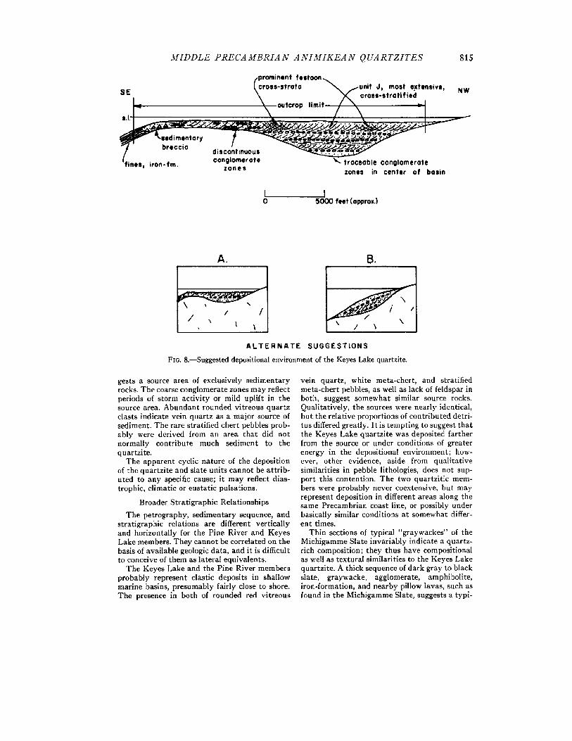
shore basin. The indefinite extension of the quartzite to the north, however, restricts inter- pretation greatly. Thinning of the quartzite to the southeast, coupled with the pinching out of some of the units present in the area of maximum width of outcrop, can be explained by deposition in a basin that either subsided more in this cen- tral area or was initially deeper here. To the southeast a shallower area or one of less subsi- dence existed in which a thinner veneer of sedi- ments was deposited. Persistent conglomerate zones are present in thicker deposits, discontinu- ous ones in the thinner (fig. 8).
Johnson (1958) has interpreted the Little Commonwealth area as one in which the abrupt grading of the quartzite into more cohesive finer material might produce initial dips or slopes up to 20 ° or 30 ° . The rapidly consolidated sand or chert would produce brittle layers interstratified with more plastic mud; under the high initial dip, these sediments would be unstable. Shock would prod uce failure and brecciation in this area. John- son described breccias interpreted as being sedi- mentary in origin in this area, presumably caused by failure on the steep slopes. The present writ- er's postulated area of shallower water would be in this area, and possibly the breccias were pro- duced by storm waves or strong currents striking the seaward side of the shoal, resulting in intra- formational conglomerate by ripping up the semi-consolidated sediments.
An alternate suggestion of the paleo-environ- ment is that of a wedge of sediment in continu- ously deepening water (fig. 6). The former envi- ronment is preferred, however, for the following reasons: (1) the sedimentary breccia can be explained more easily; (2) cross-strata in unit J, the uppermost sub-unit of the quartzite, do not decrease significantly in amplitude toward the southeast; (3) the nature of the persistent con- glomerate zones in the central area contrasted with the discontinuous ones in the southeast is more readily accounted for; (4) prominent local channel and festoon cross-strata in unit J may have resulted from a rotational current flow within the center of the basin, but are difficult to explain in the latter environment; and (5) unit J is found virtually the entire length of the homo- cline, and is explained more easily if deposited at approximately constant depth and energy level across the entire area.
Local laminated and interstratified magnetite- rich rocks above the quartzi te may represent deposition in isolated parts of the basin under quiet water conditions; associated gruneritic material is suggestive of primary chemical depo- sition of siderite.
The complete absence of feldspar and other common detrital minerals in the quartzite sug-
M I D D L E P R E CA M B R I A N A N I M I K E A N Q UA R T Z I T E S 815
[,prominent festoon ~ L cross-strata \ j u n i t J, most extensive, NW
sE I \ , ,.,.i-- ,,,, o.,cr. 1 .
zone= in center of be=in
I I 0 5000 feet (epprox.)
A.
t I / ~ / I j
A L T E R N A T E
IS. -! I \ \
S U G G E S T I O N S
FIG. &--Suggested depositional environment of the Keyes Lake quartzite.
gests a source area of exclusively sedimentary rocks. The coarse conglomerate zones may reflect periods of storm activi ty or mild uplift in the source area. Abundant rounded vitreous quartz clasts indicate vein quartz as a major source of sediment. The rare stratified chert pebbles prob- ably were derived from an area that did not normally contribute much sediment to the quartzite.
The apparent cyclic nature of the deposition of the quartzite and slate units cannot be at tr ib- uted to any specific cause; it may reflect dias- trophic, climatic or eustatic pulsations.
Broader Stratigraphic Relationships
The petrography, sedimentary sequence, and stratigraphic relations are different vertically and horizontally for the Pine River and Keyes Lake members. They cannot be correlated on the basis of available geologic data, and it is difficult to conceive of them as lateral equivalents.
The Keyes Lake and the Pine River members probably represent clastic deposits in shallow marine basins, presumably fairly close to shore. The presence in both of rounded red vitreous
vein quartz, white meta-chert, and stratified meta-chert pebbles, as well as lack of feldspar in both, suggest somewhat similar source rocks. Qualitatively, the sourees were nearly identical, but the relative proportions of contributed detri- tus differed greatly. I t is tempting to suggest that the Keyes Lake quartzite was deposited farther from the source or under conditions of greater energy in the deposltlonal environment; how- ever, other evidence, aside from quali tative similarities in pebble lithologies, does not sup- port this contention. The two quartzit ic mem- bers were probably never coextensive, but may represent deposition in different areas along the same Precambrian coast line, or possibly under basically similar conditions at somewhat differ- ent times.
Thin sections of typical "graywackes" of the Michigamme Slate invariably indicate a quartz- rich composition; they thus have compositional as well as textural similarities to the Keyes Lake quartzite. A thick sequence of dark gray to black slate, graywacke, agglomerate, amphibolite, iron-formation, and nearby pillow lavas, such as found in the Michigamme Slate, suggests a typi-
816 TOR H. N I L S E N
P i n e . . . . . . r o i ,
r ~ q ' , gT/::.:Z , ' . ~ ~ " . G ~ J ' t
,' ' -"1, . . . , . - ) ' ( \" J "'"'\ t , \ " , , J Y
-
t . . . / . ,<, ,
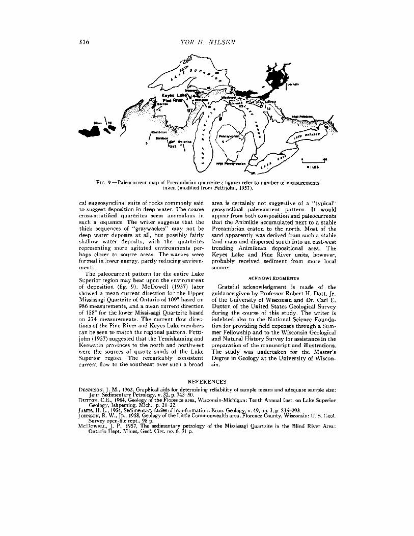
FIG. 9.--Paleocurrent map of Precambrian quartzites; figures refer to number of measurements taken (modified from Pettijohn, 1957).
cal eugeosynclinal suite of rocks commonly said to suggest deposition in deep water. The coarse cross-stratified quartzites seem anomalous in such a sequence. The writer suggests that the thick sequences of "graywaekes" may not be deep water deposits at all, hut possibly fairly shallow water deposits, with the quartzites representing more agitated environments per- haps closer to source areas. The wackes were formed in lower energy, partly reducing environ- meflts.
The paleocurrent pattern for the entire Lake Superior region may bear upon the environment of deposition (fig. 9). McDowell (1957) later showed a mean current direction for the Upper Mississagi Quartzite of Ontario of 109 ° based on 986 measurements, and a mean current direction of 158 ° for the lower Mississagi Quartzite based on 274 measurements. The current flow direc- tions of the Pine River and Keyes Lake members can be seen to match the regional pattern. Petti- john (1957) suggested that the Temlskaming and Keewatin provinces to the north and northwest were the sources of quartz sands of the Lake Superior region. The remarkably consistent current flow to the southeast over such a broad
area is certainly not suggestive of a " typical" geosynclinal paleocurrent pattern. I t would appear from both composition and paleocurrents that the Animikie accumulated next to a stable Precambrian craton to the north. Most of the sand apparently was derived from such a stable land mass and dispersed south into an east-west trending Animikean depositional area. The Keyes Lake and Pine River units, however, probably received sediment from more local sources.
A C K N O W L E D G M E N T S
Grateful acknowledgment is made of the guidance given by Professor Robert H. Dott, Jr. of the University of Wisconsin and Dr. Car[ E. Dutton of the United States Geological Survey during the course of this study. The writer is indebted also to the National Science Founda- tion for providing field expenses through a Sum- mer Fellowship and to the Wisconsin Geological and Natural History Survey for assistance in the preparation of the manuscript and illustrations. The study was undertaken for the Master 's Degree in Geology at the University of Wiscon- Sl n.
REFERENCES DENNISON, J. M., 1962, Graphical aids for determining reliability of sample means and adequate sample size:
Jour. Sedimentary Petrology, v. 32, p. 743-50. DUTTOIq, C.E., 1964, Geology of the Florence area, Wisconsin-Michigan: Tenth Annual inst. on Lake Superior
Geology, Ishpeming, Mich., p. 21-22. JAMES, H. L., 1954, Sedimentary facies of iron-formation: Econ. Geology, v. 49, no. 3, p. 235-293. JotiNso~, R. W., JR., 1958, Geology of the Little Commonwealth area, Florence County, Wisconsin: U. S. Geol.
Survey open-file rept., 98 p. McDoW~LL, J. P., 1957, The sedimentary petrology of the Mississagi Quartzite in the Blind River Area:
Ontario Dept. Mines, Geol. Circ. no. 6, 31 p.

MIDDLE P R E C A M B R I A N A N I M I K E A N QUARTZITES 817
McKEE, E. D., REYNOLDS, M. A., AND BAKER, C. H., JR., 1962, Experiments on intraformafional recumbent folds in cross-bedded sand: U. S. Geol. Survey Prof. Paper 450-D, p. DI55-D160.
MCKEE, E. D., AND WEIR, G. W., 1953, Terminology for stratification and cross-stratlficatlon in sedimentary rocks: Geol. Soc. America Bull., v. 64, p. 379-90.
MENGEL, J. T., JR., 1963, The cherts of the Lake Superior iron-bearing formations. Unpublished Ph.D. Thesis at the University of Wisconsin, 140 p.
PETTUOrIN, F. J., 1957, Paleocurrents of Lake Superior Precambrian quartzites: Geol. Soc. America Bull., v. 68, p. 469-48O.
STEEL, R. G. D., AND TORRIE, J. H., 1960, Principles and procedures of statistics. New York, McGraw-Hill, 481 p.
WILLIAMS, H., TURNER, F. J., AND GILBERT, C. M. 1954., Petrography. San Francisco, W. H. Freeman, 406 p