Embed Size (px)
Citation preview

48
Chapter II
Geographical Setting
To understand the study area properly, its geographical background is
to be analysed, as the concerned elements are responsible for bringing upto
present situation and set-up of the region. The physio-cultural character is
being explained with its most important points under the following heads:
1. Physical Setting
2. Socio-Economic Setting
Physical Setting
Location and Extent
Almora district is one of the thirteen districts of Uttarakhand. It
nestles mainly in the lap of the Lesser or Middle Himalaya. Its latitudinal
extent is 29º5' north to 29º50' north. Longitudinally it lies between 79º2' east
to 80º39' east1. It is situated between Ramganga and Panar valleys and is
interspersed with many smaller hill ranges like Ranikhet range, SyahiDevi
range and regions like Salt-Manila and Dhikala regions. Its western
boundary is flanked by the Ramganga valley and the middle part constitutes
the well-developed Suyal-Kosi valley. Saryu river valley marks the
boundary in the north. The bordering districts of Almora are Champawat &
Pithoragarh in east, Bageshwar & Chamoli in north, Pauri Garhwal in west
Estelar

49
& Nainital in south. Pithoragarh, Champawat & Bageshwar districts were
previously parts of Almora.
Almora is one of the oldest district towns of the whole region, though
its origin leads back to the monarch states of 11th century. The history of this
region can be classified into four phases, which have been well-recognized
by historians (Atkinson2 and B.D. Pande3). Monuments of pre historic
period, various cave paintings & inscriptions exits even today. Among them
the rock shelter, "Lakhudiar" near Barechhena is prominent for pre historic
rock painting. Other such popular rock shelters also exist in Kasardevi,
Falsima etc. The king of Chand Dynasty, Balo Kalyanchand established the
city as his capital in 1563. His descendants developed & expanded the city
in later years. Lakhanpur, Bairath, Masi, Taleshwar, Tamadhaun, Syalde,
Dunagiri, Dwarahat, Ranikhet, Jageshwar, Binsar etc. are the historical
places of Almora, where its glorious stories lie. Great personalities like
Swami Vivekananda, Uday Shankar proved the historical significance of the
place by visiting Almora. During the British period there were three districts
in Kumaon before 1891. After conquering the Kumaon state from gorkhas in
1815, the Britisher developed it as a district, with boundaries up to the
eastern part of Garwal divison. Even today Almora in itself is an
introduction to a vast region of Uttarakhand. (Fig 2.1)
Estelar

50
Estelar

51
This district is surrounded by Chamoli and Bageshwar districts in the
north, Pauri Garhwal in the west, Nainital district in the south and
Pithauragarh and Champawat districts in the east. Its total area is 3689.34 sq
kms and total population is 6,21,927; male population is 2,90,414 and
female population is 3,31,513 (2011).
For the administrative purposes Almora district is divided into 9
tahsils, namely Almora, Ranikhet, Bhikiyasen, Bhanoli, Someshwar, Jainti,
Chaukhutiya, Salt and Dwarahat. It has been further divided into 11
development blocks which are Hawalbagh, Bhaisiyachhana, Dhauladevi,
Salt, Takula, Tarikhet, Dwarahat, Bhikyasen, Syalde, Lamgara and
Chaukhutiya. Almora district comprises of 131 Nyay Panchayats and 2245
Gram Sabha, of which 2147 are populated and 98 are non-populated
villages. The district has 1122 gram panchayat in all. In Almora district,
Almora town is the headquarter and a Municipal Board, while Dwarahat is a
town area and Ranikhet a cantonment board.4
Geology
The lithology, stratigraphy and the structure of the study area are
complex phenomena, mainly of caingzoic era. Evidences of several orogenic
movements of different geological times and their resultant structural
complexity can be easily traced out and visualized in the region.
Estelar

52
Several attempts have been made to study the geological environment
of the Kumaon Himalaya. Mention may be made of the work of Auden
(1937)5, Heim and Gansser (1939)6, Nautiyal (1943-44)7, Merh (1968-
1977)8 and Valdia (1978, 1979, 1980)9.
The study area falls in the physiographic-cum-geological unit of the
Lesser Himalaya. This is separated by the Main Central Thrust (MCT) from
the Greater Himalaya in the north. This is delimited by Krol or Main
Boundary Thrust (MBT) in the south. Between these two regional planes of
separation, the pre-Cambrian and Palaeozoic sedimentaries with granite-
injected metamorphics are visible in the succession of three thrust sheets or
nappes. Sandwiched between these two well-defined structural boundaries,
i.e. MBT (south) and MCT (north), each tectonic unit of the Lesser
Himalaya is characterized by its distinct lithology,structural setting,
deformation of the rocks and geomorphic peculiarities10. Valdia has
recognized the existence of four litho-tectonic units in the study area from
north to south, all belonging to the Lesser Himalaya.11 (Fig 2.2)
(a) Jaunsar-Berinag-Bageshwar Nappe: In the Inner Lesser Himalaya,
Deoban and Mandhali formations is thrust over by a thick succession of
Berinag quartzites. The Berinag has been correlated by most of the earlier
workers with the Nagthat formation of the Jaunsar group.12 The Berinag
rocks have discordant relation with the underlying Tejam group, such as
Estelar

53
Estelar

54
structural discordant, shearing-shattering, mylonitization of rocks along the
contact, the allenuation or even elimination of the Mandhali formation so
that the Berinag rests directly on the Deoban formation.
(b) Almora and Bageshwar Nappe: The Almora-Dudatoli crystalline mass
occurs in the form of a huge syncline and shows a great complexity in
composition; although a change in crystalline composition has also been
observed from north to south. It is the largest of the crystalline thrust sheets
and separates the outer zone of Krol formation from the inner sedimentary
belt often termed as the Deoban-Tejan zone. The Ramgarh Nappe of the
outer Lesser Himalaya is overthrust by a huge sheet of Almora and
Bageshwar group of medium grade metamorphics which are penetrated by
pre-Cambrian Synkinematic granodiorites of the trondhjemitic suite and post
Kinematic granite adamellites.13
(c) Chail-Barkot (Bhatwari- Ramgarh) Nappe: Ramgarh thrust is situated
on the base of Nagthat quartzite and basic volcanies. Valdia has recognized
the Ramgarh Nappe as a continuation of middle metamorphosed flyschoid
group penetrated by about 1000-1200 million years old granitic
porphyroid.14
(d) Krol Nappe: The Krol belt is extended from north-west to south-east
and covers the south-western part of the study area (Tarikhet, Bhikiyasen
Estelar

55
and Salt blocks). Comparatively oldest rocks of the Krol series include
slates, phyllites, sandstones and intercalated limestone.15
In the study area, however, there is conspicuous absence of boulder
beds above quartzites. A peculiar development of the Krol formation has
often been observed in certain western sections. The Lesser Himalayas are
composed of tectonically compressed blocks of Paleozoic and Mesozoic
crystallines, metamorphics, and sedimentary rocks. The Main Central Thrust
is a major tectonic feature of the Himalayas and has brought the crystalline
rocks of the Higher Himalayas over the younger sedimentaries. The true
amplitude of these movements cannot be determined. Many researchers
consider these overthrust overlappings to be due to large scale movements.
The almost complete absence of fossils in the Lesser Himalaya leaves
many structural and stratigraphic problems unsolved. This casts some doubts
on certain stratigraphic interpretations. The Lesser Kumaon Himalaya
includes a thrust-bound sector delineated by two tectonic planes - the Main
Boundary Fault to the south and the Main Central Thrust to the north. Many
workers have postulated existence of the regional inversion of sedimentary
pile. There are two elongated tectonic belts of sedimentary/metasedimentary
rocks separated by an ESE-WNW trending Almora-Dudhatoli Crystalline
zone. The Outer Sedimentary Belt to the south of the crystalline mass is the
Estelar

56
Estelar

57
Krol Belt while the Inner Sedimentary Belt to the north constitutes the
Deoban-Tejam zone.
Physiography
The entire region falls within one physiographic unit, the Lesser
Himalaya. The area, on an average, reflects a rough undulating terrain which
is dissected by several small and large perennial and non-perennial streams.
High mountain ridges and deep river valleys are the common features of the
orography of the area. The altitudinal range of the relief varies from about
600 mtrs to 3000 mts . (Fig 2.3)
The study area presents a complicated mosaic of mountain ranges,
hills and valleys, deeply dissected topographies and small to large patches of
flat lands.16 The low altitudinal zones in south, south-west, east and the
central parts ( Syalde, Bhikiyasen, Hawalbagh blocks) are demarcated by
contours of 600-1800 mts; while the zone of maximum elevation in the north
(Chaukhutia and Dwarahat blocks) are extended generally upto 2400 mts.
Presence of ranges (1800-2400 mts and slightly above) in the middle
section of the study area (Binsar, Vridha-Jageshwar, Bhatkot etc) is an
interesting feature. For detailed study, the area has been divided into the
following physical units:
Estelar

58
(a) Eastern Himanchal Ranges and Hills: The main peaks here are
Jageshwar (2326 mt), Banaridevi (2065 mt), Kasardevi (1985 mt) and
Sitlakhet (1690mt).
(b) Western Himanchal Ranges and Hills: These ranges extend in the
western part of district in north-south direction. Syahidevi (2190 mt),
Ranikhet (1890 mt) and Chaubatiya (2082 mt) ranges and peaks are the
important features. (Fig 2.4)
Drainage
The drainage system of this region has been influencing nearly every
aspect of the people’s lives. These have also transformed the economic and
cultural phenomena of the region. The settlements in particular have always
remained under their absolute control.
The drainage pattern is generally of dendritic type. The entire area is
characterized by many large and small perennial and seasonal rivers and
rivulets. The important rivers of the district are Ramganga, Kosi, Gagas,
Panar, Suyal etc. These have shaped the economic and cultural features of
the whole region. Two major river-systems can be recognized: (Fig 2.5)
1. The Kosi system : Originating from Bhatkot range at an elevation of
2528 mts near Kausani, it flows through Binsar, Bhatkat, Syahidevi and
Takula-Basauli hills in south and south-west direction. It drains a major
portion of the study area. Suyal is the main tributary of Kosi river. Binsar-
Estelar

59
Estelar

60
Almora ridge, extending north-east to south-west separates the Kosi
catchment from the Suyal basin. After their confluence at Kwarab, the
stream flows in westward direction. Someshwar valley is the most
significant landform within this system.
2. The West Ramganga system: Originating from the southern slopes
of Dudhatoli range in Chamoli district, it drains the north-western part of the
district. The principal tributaries of Western Ramganga river are Gagas,
Kanchan Gad, Basola Gad etc. This river system has a broad fertile valley of
Chaukhutiya-Ganai region. After the merger of Gagas at Bhikiyasen, the
channel flows towards south-west and enters Garhwal division.
Rivers of the region have formed deep valleys which are sometimes
narrow and sometimes broad in accordance with the lithology17. Flat
extensive terraces and plains are one of the main features of the Katyur
valley. Other extensive valleys are Someshwar valley, Chaukhutia-Ganai
valley and Dwarahat valley.
Climate
Climate not only influences the biogeographical phenomena but it
also influences the socio-economic and cultural aspects of the concerned
region.18 The study area enjoys the colder variety of the monsoon climate.
Geographical setting including longitudinal and latitudinal location,
Estelar

61
topography and distribution of flora etc are some prominent elements which
control the climate to a great extent.
The region is characterized by a large variety of micro-climates,
varying from sub-tropical in low river valleys to temperate on slopes and
peaks of moderate to high elevation and alpine at very high altitudes.
Undulating topography creates diversity in temperature and precipitation
within relatively short distances. Based mainly on thermal conditions, the
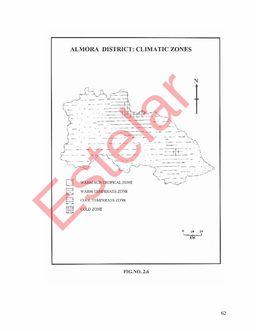
region can be categorized into the following climatic zones: (Fig 2.6)
(i) Warm sub-tropical zone: found at elevations 600 – 950 mts; mean
annual temperature: 18.9˚ – 21.1˚c
(ii) Warm temperate zone: 950 – 1830 mts; 13.9° - 18.9°c
(iii) Cool temperate zone: 1830 – 2440 mts; 10.3° - 13.9°c
(iv) Cold zone: 2440 – 3000 mts; 4.5° - 10.3°c
Cloudless sky, transparent atmosphere, calm nights, heavy dew and
great temperature variations etc are the main characteristics of the autumn
and winter seasons in the study area. The mean monthly temperature falls
below the freezing point sometimes at several places. By the end of
December, northern dry winds are well-established and produce much snow-
fall at higher elevations. Sometimes they result into severe blizzards.
The mean monthly temperature of Almora and Ranikhet respectively
vary from 7.9 and 7.8°c in January to 23.9 and 22.1°c in June and the mean
Estelar
62
Estelar

63
annual precipitation of these places are 104.0 cm and 129.0 cm respectively.
The period from May to July is the hottest. Pleasant nights and very hot days
are the principal characteristics of lower altitudes in the summer season.
The region experiences moderate rainfall. Monsoon arrives in the
second or third week of June. Most of the rainfall (approximately 60%) is
recorded between June and September. August is the month of maximum
relative humidity.
Almora has a completely mountainous climate, which is majorly
influenced by the monsoons. It has a moderate type of climate. The summers
are warm in the morning and pleasant in the evenings. The temperatures in
summer usually vary between 15 and 30 degrees Celsius. The winters are
cold and sunny during the daytime while the nights are very cold with
temperatures falling below the zero degree mark.19 The monsoon season
starts in July and can last till September.
Snowfall is quite a regular phenomenon here since the temperature
can fall upto -2 degree Celsius during the winter season. However, the fun of
walking among the hills in warm sunlight during daytime cannot be
described in words. Almora is quite well known for healthy atmosphere
which cures people of many ailments. The monsoon season starts in the
month of June and lasts till August. The rainfall can be very heavy here.
Average annual rainfall is 30 cms, 80% of which is received during the rainy
Estelar

64
season only. Rains last generally for two months of July and August.
Winters are extremely cold with temperature as low as 5º-9º c. Summers are
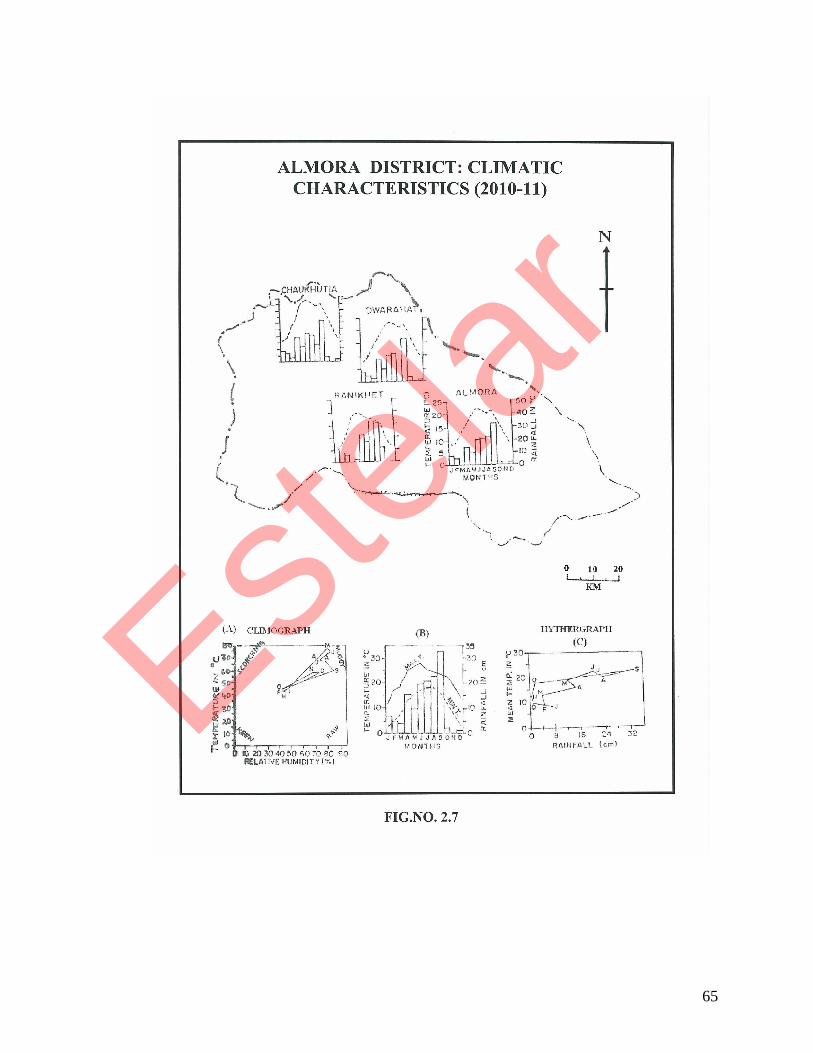
warm and dry. Temperature ranges between 25º-30ºc. (Fig 2.7)
Table No. 2.1
Climatic characteristics of Almora district 2010-11
Months Average
Temperature (ºc)
Average
Rainfall (mm)
Relative
Humidity (%)
No. of
Rainy Days
January 8.00 78.40 58.00 3
February 8.75 56.90 41.00 8
March 13.40 40.00 45.00 4
April 16.25 157.40 62.00 8
May 19.50 100.80 66.00 10
June 22.80 208.00 56.00 11
July 22.40 209.40 70.00 14
August 20.75 233.60 77.00 15
September 22.50 331.00 70.00 12
October 17.88 22.10 53.00 4
November 13.30 00.00 49.00 0
December 9.90 17.80 51.00 2
Source: Vivekanand Parvatiya Krishi Anusandhan Sansthan, Almora
Estelar
65
Estelar

66
Natural Vegetation
This is the most important part of the geo-physical aspect of Almora
district. It plays a major role in the socio-economic scenario of the whole
region and influences it very deeply. Forests occupy nearly 51% area of the
district.20 Changing thermal conditions and varying relief control the
distribution of natural vegetation. The forests have plenty of broad-leaved
evergreen plants like Baanz, Buransh. Higher altitudes have Deodar forests.
But in recent years Pine forests are growing rapidly which is not favourable
for the environment. Another problem facing the natural vegetation is the
rapid depletion on account of the growing demands of the ever-growing
population. Major forest areas are converted into farmland to support the
basic food supply of the people. Absence of the alternate occupational
opportunities is also responsible for this transformation. Pine and Oak are
the main trees, Kaphal, Buransh, Deodar, Uttis, Ayar etc are other main
species. Ghingaru, Kurie (lantana) Cactus & grass are found in dry areas.
Changing thermal conditions and varying relief control vertical
distribution of natural vegetation. The forest types of the district can be
classified in to the following categories. (Fig 2.8)
(i) Hill Sal Forests
(ii) Moist Mixed Deciduous Forests
(iii) Chir Forests
Estelar

67
(iv) Banj-Oak Forests
(v) Shrubs
(i) Hill Sal Forest (below 800 mt): Extending upto 800 mts of altitude, it
has less areal coverage in the district. These types of forests are found in the
south-eastern parts of the study area.
(ii) Moist Mixed Deciduous Forest (600-1500 mt): It can be observed
along exposed slopes with poor soil, where sal is not so well adapted. The
common associated species are Harar, Barar, Tun, Rur and Dalchini etc.
(iii) Chir Forests (800-1800 mts): Maximum area of the district falls under
this elevation category. Consequently, most of the forest cover is of this
type. Pine is the dominant species. In cooler areas of above 2100 mts
elevation, Pine is replaced by Oak and other broad-leaved species. Under-
growths are usually scarce due to acidic nature of soil in Pine forests.
(iv) Banj-Oak Forests (1500- 2400 mts): This type is found mostly on
southern slopes. An important character of this species is its capacity to
establish itself on the moist unfavourable slopes.
(v) Shrubs: In dry areas, shrubs, Cactus and grass are found.
Great varieties of wild life species are found in the district. Forests
abound in plenty of birds and wild animals. Varied nature of terrain and
climate accompanied by sparse human settlements provide a good
environment for these animals.
Estelar

68
Estelar

69
Soil
Soils are the reflection of geological setting, relief, climate and natural
vegetation and thus characterize the personality of region. Our study area
has at some places very thick, well drained soils formed in a loamy mantle
and sandy or gravelly outwash sediments. These soils are on till plains,
moraines, stream terraces, and outwash plains. They have moderate
permeability in the upper part and rapid permeability in the lower part. Slope
gradient range from 0 to 18 percent.
In general, the soil cover of mountainous parts of the region is thin.
Thick layers of soils are distributed mainly in the valleys and broad river
tracts. Absolute rock exposures are the prominent features of crystalline
basements, particularly in the high altitudes of Himadri. Mainly on the basis
of chemical composition and fertility of the soils, the study area can be
divided into five main soil regions. (Fig 2.9)
(i) Meadow Soils
(ii) Red Looms
(iii) Podzol Soils
(iv) Brown Forest Soils
(v) Mountain Meadow and Glacial Soils
(i) Meadow Soils: This type of soil is mainly confined near the water
courses and cool shady places. Loam, varying from clayey to sandy is quite
Estelar

70
common in this group. Owing to very high water table, these soils always
remain moist and are very fertile, therefore these are used for intensive
cultivation. Upto about 1200 mts elevations in the humid sub-tropical
climatic zone, these soils are widely distributed, i.e. Kosi-Suyal valley and
West Ramganga- Gagas valley. The soils are neutral to moderately alkaline
and calcareous and have sometimes well-developed clay accumulation
horizon in the sub-soil21.
(ii) Red Loams: These are sedentary soils found on steeper slopes, e.g.
South Tejam range and Morenaula and Syahidevi ridges. These soils receive
maximum solar radiation and are always dry. The extent of cultivation is
comparatively less. Such soils of warm temperate zone are developed
generally on the lower hill slopes.
(iii) Podzol Soils: Areas ranging between 1800 mts and 3000 mts in cool
temperate and pertinent cold climates have this type of soil. Forests of Pine
and other coniferous varieties develop acidic brown podzol soil, while Oak
forests produce deep brown forest soils22. Soil texture is generally silty loam
to loam with dark brown to light brown colour. Organic contents and
nitrogen vary from medium to high; whereas phosphorous and potassium
contents are low to high. Soil reaction is slightly neutral to moderately
acidic. These soils are widely spread in the higher parts of the region. These
areas are not very frequently used for agricultural practices.
Estelar

71
Estelar

72
(iv) Brown Forest Soils: Associated mainly with the pine forest zone, these
soils are of sandy loam to loamy types. These soils although rich in
decomposed organic matters, are acidic in nature due to their composition of
pine leaves. In favourable conditions, the soils are quite deep. Nitrogen
content varies from medium to high; while phosphorous content is low to
medium and potash content is medium. Chemical reaction is moderately
neutral to acidic23. At several places, the forest land has been converted into
terraced fields.
(v) Mountain Meadow and Glacial Soils: At high altitudes of 3000 mts
and above, soils of granitic sandy loam texture are found. Owing to steep
slopes and cold climate, the soil formation in this zone is very low and the
depth too of the soil is very less. The organic status is also very low.
The remaining part of the region is useless for agriculture: soils being
stony, thin-layered and less-fertile and are not of much use.
Estelar

73
Socio-Economic Setting
The physical personality of the district reflects its clear impact on the
morphology, structure and dynamics of cultural environment. The multi-
dimensional character of cultural environs, i.e. agriculture, small scale
industries, transport and communication and socio-cultural institutions have
produced some particular properties which, undoubtedly, has a great role to
play in the geography of the region.
Economic Activities
The economy of the area happens to be the result of physical-
environmental resource conditions and the techno-economic production
level of the society under study. In an agro-based rural economy of the
subsistence society, the main economic activity of the people is agriculture.
i.e.-
Agriculture: Inspite of recurrence of many physical and cultural
constraints such as rough climate, problems of irrigation, poor economic
conditions, lack of skill of peasants, small size of holdings, scattered and
tiny fields, lack of adequate inputs and proper technology etc, agriculture has
remained the backbone of district’s economy. About 74% of the working
population is predominantly engaged in it. Agriculture includes both crop
Estelar

74
farming and animal husbandry. Crop farming is done by the traditional
intensive subsistence farming system. Field crops dominate; paddy, maize,
millets and wheat form the staple source of the diet and are the major
products. But since agricultural activity is seasonal in nature, the farmers are
actively engaged in it only for four months of the year. During the rest of the
year, because of lean season, the people live in a condition of
underemployment or unemployment. Lands having even more than 40%
slope gradients are being utilized for cultivation. 18% of total land area of
the district falls under the category of net sown area. Of these, only 8.5% has
irrigation facility of any kind at all and remaining 91.5% depends upon
rainfall for irrigation. The well-irrigated, fertile valley of Takula,
Chaukhutia, Dwarahat, Syalde blocks have registered potential agro-
economic structures.
The ‘Upraon’ (uphill lands) of Hawalbagh, Dhauladevi, Lamgara and
Tarikhet blocks are rich with fruit belts. The percentage area under orchards
to total area is highest in Lamgara block . Bhikiyasen, Bhaisiyachhana and
Salt blocks have poor representation in agriculture as well as in horticulture.
Livestock rearing is rather the essential part of agriculture and a
complementary source of cash income in the rural households. The farmers
rear buffaloes, cows, oxen and goats for different purposes. Buffaloes are
Estelar
75
mainly reared as milching animals. Goats are kept largely for meat. Cows
are equally important for milk productions as well as for breeding oxen,
which are used for ploughing fields. Apart from these, livestock rearing is a
source of manure for maintaining soil fertility.
Agro-Industry and Trade: Industrialization is regarded as a key to
economic development in any region. The objectives of maximum economic
development and production specialization in a region can be obtained
through careful industrial planning which entails proper assessment and
careful utilization of resources, adequate provision of infrastructural
elements and initiation of suitable industrial production cycles24. Industries
and trading are less prevalent activities in the study area. Less than 2% of the
work force is engaged in it. Before the advent of planned development era,
the industrial activities of this region were confined to the implementation of
Hill Wool scheme. Under this scheme, carded wool was given to villagers,
who used to spin it into yarn. This yarn was used in training-cum-production
centres for making woolen khadi. The Bhotiyas who acquired skill in
manufacturing of woolen handloom, involved themselves in this scheme.
There are a few cottage industries which are dependent on agro-
products for their raw material. These include manufacturing of spices,
pickles, honey, juice, jam, and other small-scale industries like dairy farms
Estelar

76
etc. The present industrial setup of Almora district can be categorized in two
sectors: (i) Cottage Industries and (ii) Small Scale Industries
(i) Cottage Industries: About 1025 persons are engaged in wool-weaving
activity; the annual value of their production being Rs. 25.37 lacks. Sri
Gandhi Ashram and some local institutions are also engaged in
manufacturing and sale of the woolen products. The district has about 65
units employing 172 persons, who manufacture copper –ware worth Rs 7.72
lacks annually. They are mainly concentrated in Takula block and Tamta
Mohalla in Almora.
(ii) Small Scale Industries: There are 134 small industrial units in the
organized sector25. Oil procuring, saw-milling, furniture making,
pharmaceuticals unit, nut and bolt making, soap manufacturing, woolen
industries etc are some important industrial activities. A drug factory is
working at Ranikhet, in which ayurvedic medicines extracted from various
medicinal and aromatic plants are manufactured.
In trade, agricultural products form the major items of rural supply,
whereas both urban-industrial services and foodgrains form the market
supply. Animals and animal-products are the sources of cash income to the
farmers. Milk is traded independently as well as through the depots of the
Estelar

77
government dairy. Fruits and vegetables are the major items of rural supply
to market centres.
The traditional artisans are engaged in professional family businesses.
However these different family-based industrial enterprises provide only a
few employment opportunities in the study area. In trading activity, catering
of daily consumption needs from village shops is prominent. These shops
are opened as a complementary source of income to agriculture and a side
business to marginal farmers respectively. Apart from the above-mentioned
activities, some other odd jobs such as portering, construction labour, repair
and lumbering provide some employment to the people.
Transportation and Communication
Transportation and communication form the basic infrastructural
facilities for rural development. The unfavourable geographical environment
has restricted the development of means of transport in the region. Rugged
terrain, scattered population settlements are the main reasons for the under-
development of the transportation facilities in the district. The only
important available transport system is the road transport. The nearest
railway station is Kathgodam in Nainital district, situated at a distance of
about 90 kms from Almora town.
Estelar

78
Estelar

79
Though there have been large scale road constructions recently, there
are still many areas which remain abandoned. The total length of metalled
roads in the district is 1892 kms, out of which 129 kms are under the
category of National Highway (2010-11). Length of roads per lakh of
population is 287.6 kms. Length of roads per thousand sq. km. is 813.38
kms. The roads of the region can be categorized into four groups:
1. National Highway Extension with a total length of 129 kms.
2. State Highways with a total length of 341 kms.
3. Major district roads – 635 kms.
4. Unmetalled roads- 660 kms.
Traffic flow on the main road- Almora-Haldwani- is quite high. The
other roads, like Almora-Ranikhet, Almora-Bageshwar also have
considerable traffic flow. Kumaon Motor Union is the major transport
agency. Many private taxis also run on important routs. (Fig 2.10)
Density of metalled roads is very low in comparison to unmetalled
roads. Majority of the blocks fall under the category of very low density, like
Syalde and Chaukhutiya. High density of metalled roads per thousand sq.
km. of area is found in Hawalbag, Bhaisiyachhana and Dwarahat. (Table no.
2.2 & Fig 2.11)
Estelar

80
Table 2.2 Block-wise metalled roads- Almora district (2010-11)
2010-11 Blocks
Length of metalled roads(kms)
length of metalled roads per lakhs population(kms)
length of metalled roads per th. sq. km.(kms)
Syalde 126 255.78 521.96 Chaukhutia 109 222.36 567.42 Bhikiyasen 154 406.41 704.49 Tarikhet 202 292.37 830.6 Salt 213 346.12 705.3 Dwarahat 203 329.79 978.79 Takula 100 220.63 880.29 Bhaisiyachhana 108 408.94 1120.34 Hawalbag 266 395.5 1318.14 Lamgara 150 316.81 700.28 Dhauladevi 201 319.85 619.61
Source: Sankhikiya Patrika: Almora, 2011
Fig 2.11
Bar Graph: Block-wise Length and Density of Roads in Almora (2010-
11)
0
200
400
600
800
1000
1200
1400
Syalde
Chaukh
utia
Bhikiya
sen
Tarikh
et SaltDwara
hat
Takula
Bhaisiy
achh
ana
Hawalbag
Lamgara
Dhaulad
evi
length of metalled roads(kms)
length of metalled roads perlakhs population(kms)length of metalled roads per th.sq. km.(kms)
Source: Sankhikiya Patrika, Almora 2011
Estelar

81
Road Accessibility of the Area: The accessibility of the area through roads
is divided into three categories.
(a) Area of high accessibility: These are mainly situated in the southern
portion of the district. Two urban centres, namely Almora and Ranikhet have
well-connected road-network, which joins them with most of the other rural
settlements as well as the other urban areas of the state. Almora-Ranikhet-
Khairna is the busiest triangular route with maximum traffic flow.
(b) Area of medium accessibility: The medium accessibility area is
considered as (i) between 10-15 km from the main roads, shown with
unbroken lines on the map, and (ii) 5-10 km from the tributary roads, shown
with broken lines. Since these areas are surrounded by high accessibility
area, the distribution pattern is somewhat similar.
(c) Area of low accessibility: These are the remote areas, scattered in
between very rough terrain and dense jungles. The northern portion of the
district has the maximum proportion of low accessibility. These pockets
have mostly unmetalled roads. Few settlements are highly inaccessible.
Communicational Facilities: Communicational facilities are satisfactory
only in urban centres. Telephone and post services are mainly concentrated
in urban localities and centres of administrative and defense importance.
(a) Post Offices: Inspite of the fact, that migration is a very common
phenomenon in the region, the post and telegraph services are not very well
Estelar

82
developed here. Number of post offices is less comparing to per lakh of
population that is found in maximum of the blocks due to the remote and
scattered location of villages. A total of 316 post offices are currently
working in the district. (Table 2:3)
(b) Telephones: The importance of this mode of communication need not be
justified as this is one of the fastest. Earlier this facility was concentrated in
the urban centres, but now maximum of the villages are connected by
telephones in the remote areas as well. Though the number, per lakh of
population is still very low. Total number of telephone connections in 2010-
11 is 29,256 in all. (Table 2.3)
Table 2.3: Block-wise number of post-offices and telephones
2010-11 Blocks
No. of post offices per lakh of population
No. of telephones per lakh of population
Syalde 44 685 Chaukhutia 39 1852 Bhikiyasen 53 2850 Tarikhet 50 5580 Salt 61 668 Dwarahat 48 2400 Takula 47 1414 Bhaisiyachhana 30 1085 Hawalbag 49 13356 Lamgara 100 2426 Dhauladevi 70 1134
Source: Sankhikiya Patrika, Almora 2011
Estelar

83
Education and Health
Educational facilities are well provided to in the district. The overall
literacy is 81.06% (2011) which is well above the national average. Male
literacy is 93.57% whereas female literacy is 70.44%. There are a total of
1538 Junior Basic Schools, 242 Senior Basic Schools, 210 Higher
Secondary Schools, 2 Under-Graduate colleges and 4 Post-Graduate
colleges.
Medical and health facilities in this region are inadequate, causing
deaths even by ordinary diseases. Considering the physical inaccessibility,
there is dearth of primary health care centres. There is also scarcity of
hospitals and bed facilities. The region accounts for nearly one bed per 694
persons.
The rural health care system is a three tier structure. It has “Sub-
center” at the most peripheral level, “Primary Health Centre” at the
intermediate level and “Community Health Centre” at the secondary level.
The population covered by a “Sub Centre”, “Primary Health Centre” and
“Community Health Centre” are “3,000-5,000”, “20,000-30,000” and
“100,000”, respectively. In addition, there are Private Voluntary Healthy
Facilities, also. As per Uttarakhand government organizational set up, the
District is headed by a District Magistrate, who is also the chair person of
Estelar

84
the Integrated District Health Society of Almora district. The District health
set up of Uttarakhand government is headed by the Chief Medical Officer
followed by a Deputy CMO as second-in-command. Chief Medical
Superintendent looks after the Uttarakhand government hospitals in the
district.
There are 315 government health care facilities in the district. (Table 2.4)
Table 2.4: Health Care Facilities: Almora district
Category Number
District Hospital 01
Community Health Centre 04
Primary Health Centre 08
Additional Primary Health Centre 18
Sub – Centres 218
Female Hospitals 03
Leprosy Hospital (Local & Int’I NGO) 01
Ayurvedic Hospitals 51
Homeopathic Hospitals 11
ANM Training School 01
Source: Sankhikiya Patrika, Almora 2011
Estelar
85
Settlement
The spatial distribution of settlement is related with various ecological
conditions of naturo-cultural environment. There are various restrictive and
attractive naturo-cultural factors which govern the distribution, types and
patterns of rural settlements. Among the major factors, the important control
is exercised by relief, geology, drainage system, climate, soil and natural
vegetation. While among the cultural factors, transport routes, religious
centres, agricultural conditions and opportunities dominate the scene. In
short, the spatial system of settlement distribution and patterns are the
outcome of both natural and cultural environmental conditions.
Owing to the non-homogeneous environmental conditions, the
distribution of settlement in the district is irregular. The following major
zones of settlement distribution have been marked. (Fig. 2.12)
(i) Uninhabited Zone
(ii) Poorly Inhabited Zone (1 – 12 houses / km²)
(iii) Moderately Inhabited Zone (12 – 24 houses / km²)
(iv) Moderately High Inhabited Zone (more than 24 houses / km²)
(i) Uninhabited Zone: This zone of settlement occupies the areas having
more than 1800 m of altitude, which can easily be seen in all blocks of the
Estelar

86
district having such heights. The major uninhabited areas of the district are
northern slopes of Ranikhet, Syahidevi range, Jageshwar range, north-west
Takula and few parts in Chaukhutia block.
(ii) Poorly Inhabited Zone: This zone is well-marked around the
uninhabited zones. The southern part of Salt and Bhikiyasen blocks, the
marginal areas of Takula and Hawalbagh blocks have such sparse
settlements.
(iii) Moderately Inhabited Zone: This settlement zone is found in the
areas of moderate and gentle slopes. Almost all the villages are located on
the mid of the spur, where the slope gradient range between 10º-18º.
(iv) Moderately High Inhabited Zone: This zone mostly occupies valley
areas where fertile soil and gentle slopes are found. The important valleys
are Kosi, Gagas, Suyal and Western Ramganga. In Kosi valley, the major
concentration of the settlements is found in between Kausani and Kosi. The
main villages here are Hawalbagh, Manan, Someshwar and Chanoda.
Another concentration of settlements are marked in the north-western part of
the study area, i.e. West Ramganga and Gagas valleys (parts of Chaukhutia,
Bhikiyasen and Dwarahat blocks).
Estelar

87
Organization
Indo-Aryan and Mongoloid are two and distinct type of racial groups
found in the study area. First type of community includes the Brahmin,
Kshatriya and associated scheduled caste groups. They are organized under
the traditional Hindu Jajmani (Patron-client) system. But the Mongoloids are
organized as horizontal society where collective decisions are made. The
system of Jhara (free donation of labour), Perma (exchange of labour) and
Pareli (shared ownership of plough in field crop cultivation) are popular
among Mongoloids. In the Indo-Aryan cult also, Perma and Pareli are found
but this is limited within clan. In the traditionally organized societies, rich
and large landholders are the informal social, cultural and political leaders.
The landless and small farmers till the lands rented from large farmers in
50% share each. Scheduled caste groups eke out their livelihood mainly by
ploughing the lands of higher caste groups or working as landless
agricultural labourers in their fields, and also carrying on the domestic
chores in their households.
Traditionally, Brahmins are socially and ritually prohibited from
handling a plough or ploughing land. Also the higher castes never exchange
labour with scheduled caste groups. Ploughing is strictly men’s job, whereas
planting is women’s job. There is traditional division of labour as well as
Estelar

88
exchange of labour in the society. Land fragmentation is limited among
males as in earlier days. The role of women is significant in the agro-
economy. However, outside this, their importance is minimal, except within
the domestic chores of cooking, cleaning, carrying water etc and raising
children.
Institutional Intervention
Besides the traditional system of organization, there are different
institutional organizations which assist the farmers for adopting progress in
measures. Cooperatives and Agricultural Development Banks (ADB) are
providing agricultural inputs and loans to the farmers. Small Farmer
Development Programme (SFDP) is also implemented in the study area.
Under this programme, farmers are organized into several groups and are
provided with the opportunities for making a community more independent
of the traditional Hindu Jajmani system. However, the formal organizations
are also not free from these traditional informal organizations. The higher
caste people, being relatively more educated and aware, receive the
information first about the development subsidies from the government and
other agencies. They have evolved informal organization irrespective of
caste/family background. Their dominance in the organizations can not be
ignored. Therefore, newly formed formal organizations are unable to
Estelar

89
compete with deep-rooted patron-client relations and communal orders
articulated over on time and spaces in the long run. Whatever the
organizations, the deteriorating economic condition of the people has led to
continuing reduction in cooperation among the farm families. The first quest
of the farmers has become to meet the immediate requirement of food. One
can benefit more by selling labour in a competitive wage market than in a
cooperative basis in scarcity. Many of the farmers hold a small quantity of
land that can be managed by their own family members. This has led to
reduction in cooperation with the fellow farmers more than before.
Electricity Facility: Electricity plays a very important role in the process of
development. Availability of power is crucial to modernization of
agriculture, establishment of industries and running of diverse educational,
medical and other facilities. In Almora district, 95.4% villages had got
electricity till the year 2006-07. Number of villages having electricity was
1997 out of the total 2180 villages in 2004-05. The per capita annual
electricity consumption in 2009-10 was 851.86 KWh and the projection for
2010-11 was 906.29 KWh (Source: UPCL statistics). Fig 2.13 shows the
percentage of electrified villages in the blocks of Almora district.
Estelar

90
Fig 2.13: Percentage of Electrified villages to total villages (2010-11)
88.3698.1698.4
88.5198.83
94.59100
97.2886.3
82.78
86.46% of electrifiedvillages to total
villages
DhauladeviLamgaraHawalbagBhaisiyachhanaTakulaDwarahatSaltTarikhetBhikiyasenChaukhutiaSyalde
Source: Sankhikiya Patrika, Almora 2011
Banks and Financial Institutions: Banks (nationalized, private),
cooperative society and related institutions are very necessary for the
economic development of any region. They are playing very positive role in
the development of the rural areas of the district. They provide credit,
investment, fixed deposit and other schemes for the improvement of
economic conditions of the people. Unfortunately, socio-economic
conditions of the people don’t let them invest in agriculture or the allied
activities. Overall number of commercial banks is very low. Except for the
urban centres, there are very few branches of nationalized banks in the
remote areas of the district and nearly no branch of any private banks,
though cooperative banks have got a good say in the economy of the rural
Estelar

91
areas. There are altogether 50 branches of national banks, 19 branches of
regional rural banks and 9 branches of private banks in the district. (Table
2.5)
Table 2.5: Block-wise number of commercial banks
2010-11 Blocks No. of commercial banks per lakh of population
Syalde 9 Chaukhutia 9 Bhikiyasen 14 Tarikhet 20 Salt 12 Dwarahat 11 Takula 9 Bhaisiyachhana 9 Hawalbag 26 Lamgara 15 Dhauladevi 11
Source: Sankhikiya Patrika, Almora 2011
There are a number of financial institutions in Almora district to cater
to the needs of the economy. Four types of banks can be seen as:
1. Public sector: State Bank of India, Punjab National Bank, Central
Bank, Canara Bank, Bank of India, Uco Bank, Bank of Commerce,
Allahabad Bank, Bank of Baroda etc.
2. Private Sector: ICICI, HDFC
3. Cooperative Banks: Almora Urban Cooperative Bank,
Estelar

92
4. Gramin Bank: Nainital Almora Kshetriya Gramin Bank
There are a few branches of Life Insurance Corporation of India in the
district. There are a few other insurance companies working in the district
like Oriental Assurance Company Ltd.
The Vivekanand Parvatiya Krishi Anusandhan Sansthan, an ICAR
project is also actively engaged in various research programmes related to
agricultural potentials and problems of the region. It has also made some
outstanding achievements in the field of seed production, i.e. wheat, paddy,
maize, jowar and new varieties of masoor, moong, soyabean and mustard.
The extension training centre at Hawalbagh trains the community
development officials and agriculture diploma holders in various aspects of
agro-technology.
The Soil Conservation Training Centre at Majhkhali has not only
evolved some new techniques of soil conservation for Kumaon Himalaya
but has also launched a programme to train officials in this field.
●
References:
1. Joshi, S C (2004) – “Uttaranchal: Environment and Development”,
Gyanodaya Prakashan, Nainital
Estelar

93
2. Atkinson, E T (1973) – The Himalayan Gazetteer, Cosmo Pub, Delhi
3. Pandey, B D (1937) – Kumaon ka Itihas, Almora Shakti Press, Almora
4. Official Portal - Government of Uttarakhand
5. Auden, J B (1937) - The Structure of the Himalaya in Garhwal, Rec.
Geol. Surv. Ind. 71(4), pp 407-433
6. Heim, A and A Gansser (1939) – “Central Himalaya, Geological
Observations of the Swiss Expeditions of 1936”, Mem. Swiss
Soc. Nat. Sci. 73(i), pp 1-245
7. Nautiyal, S P (1943-44) - Unpublished report of the Geological Survey
of India
8. Merh, S S (1968) – “A Preliminary Note on the Structural History of the
Central Kumaon Himalaya”, Bull, Geol Soc. Ind. 5, 1-7;
Merh S S (1977) – “Structural Studies in the parts of Kumaon
Himalaya”, Hin. Geol, 7, 26-42
9. Valdia K S (1978) – “Outline of the Structure of Kumaon Lesser
Himalaya”, Saklani P S (ed), Tectonoc Geology of the
Himalaya, 1-14;
Valdia K S (1979) – “An Outline of the Structural Setup of the
Kumaon Himalaya”, Geol Soc. Ind. 20, 145-151;
Valdia K S (1980) – “Stratigraphic Scheme of the Sedimentary
Units of the Kumaon Lesser Himalaya”, Stratigraphy and
Correlation of Lesser Himalaya Formations, by K S Valdia and
S B Bhatia (eds), Hindustan Pub. Corp. Delhi, pp 7-48
10. Mishra D K, Arun Kumar and C C Pant (1983) – “Outlines of the
Geology of Kumaon Himalaya, U.P.”, India in the Himalaya:
Nature, Man and Culture by O P Singh (ed), Rajesh Pub. Delhi,
p 41
Estelar

94
11. Valdia K S (1978) – “Extension and Analogues of the Chail Nappe in
the Kumaon Himalaya”, Ind. Jour. Earth Sci. 5(1), 1-19)
12. Mishra D K, A Kumar and C C Pant, op. cit. pp 41-43
13. Valdia K S (1963) – “The Stratigraphy and Structure of the Lagaghat
subdivision, Dist Almora”, Quart. Jour. Geol. Min. Metal. Soc.
Ind. 35, 167-180
14. Tiwari M M (1982) - Trends of Urbanization in the U P Himalaya, PhD
thesis, Kumaon University Nainital
15. Kharkwal S C (1971) – “The U P Himalaya in India: Regional
Geography”, R L Singh et. al.(eds), Silver Jubilee Pub. Nat.
Geog. Soc. Of Ind. Varanasi, p 451
16. Tiwari M M (1982) - Ph D thesis
17. Kharkwal S C, 1971: The U.P. Himalaya
18. Freeman, O W and Raup, H F (1949): Essentials of Geography, London,
p 65
19. Joshi, D R and Joshi, S C (1983): General Characteristics of Climate in
Kumaon, Gyanodaya Prakashan, Nainital
20. Sankhikiya Patrika-Almora: 2008
21. Tiwari, P S (1973): Agricultural Atlas of Uttar Pradesh, G B Pant
University of Agri and Tech, Pantnagar, p 24
22. Bose S C (1972): Geography of the Himalaya, National Book Trust,
New Delhi, p 58
23. Tiwari P S, op. cit. p 26
24. Singh R L (1968) - Applied Geography, Nat. Geog. Soc. Ind. Varanasi, p
169
25. Audyogic Margdarshika: janpad Almora, 2008-09
Estelar