Embed Size (px)
Citation preview

8-1
City of Dayton 2030 Comprehensive Plan
CHAPTER 8: TRANSPORTATION
CHAPTER 8:TRANSPORTATION
INTRODUCTION
EXECUTIVE SUMMARYA Draft Northwest Hennepin County I-94 Sub-Area Transportation Study (NHCTS) has been prepared for the cities of Dayton, Rogers, and Hassan Township. This draft plan has been prepared to defi ne a long term vision of the transportation system including existing and future roadway functional classifi cations for these communities. The draft plan has not been formally adopted by all effected agencies (state, counties, and cities) at this time. The Executive Summary in this Transportation Chapter of Dayton’s Comprehensive Plan has been prepared independent of the Draft NHCTS and identifi es specifi c planning issues for Dayton’s Transportation System to create Dayton’s Transportation Plan. However, because roadway connections to neighboring communities including state and county roadways, complements Dayton’s Transportation Plan, much of the Draft NHCTS is included in this Transportation Chapter of Dayton’s Comprehensive Plan. Dayton will fi nalize its Transportation Plan for its 2008 Comprehensive Plan after the Northwest Hennepin County Transportation Study is completed and accepted.
The roadways in Dayton are shown in Table 8.1 – Short Term (2008 - 2020), Table 8.2 – Mid Term (2020 - 2030). These Tables identify the corresponding numbers on Figure 8.1- Dayton Issues Map. The roadways are identifi ed based on short, mid, and long term to provide a timeframe when roadway function/alignments and improvements might be considered. Table 8.3- Roadway Functional Classifi cation Criteria describes the various types of roadway exhibited on Figure 8.1- Dayton Issues Map. Roadway improvements will only occur based on consensus of all affected agencies; future land use/development patterns are better defi ned; and/or fi nancial resources are available to consider roadway improvements.
Table 8.1- Short Term (2008-2020)

8-2
City of Dayton 2030 Comprehensive Plan
CHAPTER 8: TRANSPORTATION
Table 8.2- Mid Term (2020-2030)
Dayton is supportive of the roadways in the previous tables based on the following:
• The interchange of I-94/Brockton Lane is at the site of the current Brockton Bridge and along Brockton Lane’s existing alignment. All connecting roadways comply with federal, state, county, and local requirements.
• CSAH 12 (Dayton River Road) is maintained over its existing alignment. However, west of Lawndale Lane in anticipation of a future Crow River crossing south of Dayton’s Historic Village CSAH 12 could be realigned to align with a future river crossing.
• Dayton is supportive of planning for a future Crow River crossing south of the Historic Village. Dayton will continue to review a future Crow River crossing with the City of Otsego, Hennepin County, and Wright County.
• Dayton is supportive of planning for a future crossing of the Mississippi River; however, recognizing its implementation would not be considered until after 2030.
GOALS AND POLICIES
Early in the Comprehensive Plan update process the City developed new goals and policies for transportation with the involvement of a resident Task Force, Planning Commission, and City Council. These transportation goals and policies identify the needs within the community for transportation and transit in order to appropriately respond to the anticipated growth in Dayton. The goals and policies listed below are specifi c to Dayton.

8-3
City of Dayton 2030 Comprehensive Plan
CHAPTER 8: TRANSPORTATION
Goal 1: Develop an integrated transportation plan that fully promotes connectivity and is coordinated with neighboring cities and counties.
Policy 1: Identify a transportation grid that effi ciently moves traffi c as development occurs and is consistent with MnDOT/Hennepin County, neighboring communities, and the land use plan.
Policy 2: Residential areas are designed to ensure excess traffi c is not penetrating into residential neighborhoods.
Policy 3: Use weight restrictions to minimize deterioration of roadways and enforce these restrictions.
Policy 4: Incorporate the use of innovative traffi c management options and technologies.
Policy 5: Develop a pavement management program that ensures City roads are being maintained cost effectively as needed.
Policy 6: Plan for expanded and improved road system to accommodate projected increases in traffi c volume accompanying planned growth and development.
Goal 2: Encourage transportation methods other then individual automobile travel.
Policy 1: Promote ride sharing by residents with the addition of park and ride lots in convenient locations.
Policy 2: Work with the Metropolitan Council to increase transit services to Dayton and encourage use by residents.
Goal 3: Coordinate transportation planning and system improvements with other government jurisdictions.
Policy 1: Continue to work with the City of Rogers and Hassan Township to develop the design of the Brockton/I-94 Interchange. Work closely with MnDOT/Hennepin County to ensure their transportation needs are met. Include developers in the area to assist in the design and implementation process. Actively explore and pursue all funding options.
Policy 2: Identify all connections/alignments to MnDOT and Hennepin County corridors in and adjacent to Dayton.
Policy 3: A Mississippi River Crossing is not identifi ed in other jurisdiction’s 2030 plans between the existing TH 169 and TH 101 river crossings. Identify the approach/options if a river crossing is included after 2030. The Brockton/I-94 Interchange design should identify the impacts to the interchange design if a river crossing is constructed. The corridor between a river crossing and interchange with I-94 shall be identifi ed.
8-4
City of Dayton 2030 Comprehensive Plan
CHAPTER 8: TRANSPORTATION
Figure 8.1- Dayton Issues Map

8-5
City of Dayton 2030 Comprehensive Plan
CHAPTER 8: TRANSPORTATION
Table 8.3- Roadway Functional Classifi cation Criteria

8-6
City of Dayton 2030 Comprehensive Plan
CHAPTER 8: TRANSPORTATION
NORTHWEST HENNEPIN COUNTY TRANSPORTATION PLAN
INTRODUCTIONThe Northwest Hennepin County Transportation Plan is a planning effort lead by the City of Rogers, Dayton, and Hassan Township. This plan was developed to articulate a long-term vision of the transportation system for these communities. This planning effort is also intended to help coordinate efforts with adjacent jurisdictions as well as other agencies such as the Minnesota Department of Transportation (MnDOT) and Hennepin County.
Over the last 20 years signifi cant growth has occurred in Hennepin County and eastern Wright County. In Hennepin County, much of this growth has occurred in cities like Maple Grove, Plymouth, Brooklyn Park, Champlin, and Rogers, while limited growth has occurred in Hassan Township and the Cities of Corcoran and Dayton. As communities like Maple Grove and Plymouth near full urbanization, more pressure to urbanize adjacent communities will occur. As a result, the Cities of Dayton and Rogers and Hassan Township recognized a need to work cooperatively and develop a more comprehensive transportation plan. Thus, they initiated the Northwest Hennepin County I-94 Sub-Area Study to further defi ne the long-term transportation system for the area including access to I-94. (Since the study began, the scope has expanded to focus on a larger area and includes portions of the interstate system.) This study has been coordinated with MnDOT, the Federal Highway Administration (FHWA), Hennepin County, and other local communities within the area including Corcoran and Maple Grove. This group is commonly referred to as “partners” or “study partners” throughout this report and is represented by the following agencies/representatives:
• City of Dayton
• City of Rogers
• Hassan Township
• City of Corcoran
• City of Maple Grove
• Hennepin County
• MnDOT
• FHWA
• Metropolitan Council
The Beard Group contributed fi nancially to the study through the City of Dayton and participated in the study because of its large property interests near Brockton Lane and I-94.
PLAN PURPOSEThe purpose of the Northwest Hennepin County I-94 Sub-Area Transportation Study is to more thoroughly investigate the supporting arterial and collector systems in northwest Hennepin County including the potential I-94 interchange access between TH 101 and CSAH 30. This will allow agencies to proactively plan for ongoing development and the needed infrastructure changes on both the local and regional systems. The development of this unifi ed plan will also help communities prepare for expected future improvements through various means including preservation of transportation corridors, coordination with land use, and directing available resources to problem areas (i.e., congestion, capacity, and safety).
By defi ning the long-term system plan for the area, local, regional, and state agencies can better plan for ongoing development and the needed infrastructure changes on both the local and regional systems. The plan will be used by the cities and township within the plan area by incorporation into their individual comprehensive plan documents.
GOALS AND OBJECTIVES OF THE LARGER STUDYTo help defi ne and guide the study, the study partners established the following goals:
Goal 1: Identify future improvements to the area’s arterial system that will enhance mobility, continuity, and connectivity among major activity centers.

8-7
City of Dayton 2030 Comprehensive Plan
CHAPTER 8: TRANSPORTATION
This goal refl ects the need to provide safe and effective roadway connections between major activity centers. Current physical constraints (freeway, rivers, railroads, parks, and existing development) create concentrations of traffi c that, as the area grows, will lead to bottlenecks and increasing congestion.
Goal 2: Use existing arterials or collectors where design and access are consistent with desired function.
This goal refl ects the desire to minimize social, environmental, and property impacts as much as possible while achieving the desired functionality out of the transportation system.
Goal 3: Encourage planning, design, and implementation of an arterial and collector system that compliments I-94 (IRC) and better supports existing and planned development while respecting existing rural character.
This goal refl ects the need to provide a strong supporting transportation system to protect important statewide corridors that provide economic benefi ts to this area and the rest of Minnesota. The intent is to provide a good balance between serving statewide needs with the need to support planned land uses for the area.
Goal 4: Encourage preservation of right-of-way for future transportation corridors through planning processes, right-of-way dedications, and direct purchases.
Due to development pressures, viable locations for future transportation corridors may be lost and the ability to develop a well-coordinated system will be put at risk. This goal refl ects the need to actively preserve future transportation corridors by preserving right-of-way for local collector and arterial facilities.
Goal 5: Enhance the safety of the traveling public through a variety of measures including:
• Access management along roadways;
• Safe roadway design practices and standards;
• Off-street trail system in key corridors for pedestrian and bicyclists;
• Matching trip types to facility types (i.e., attracting short trips to the collector system and medium to long trips on the arterial system); and
• Providing safe facilities is a key responsibility for agencies. Agencies should focus on developing and implementing practices and policies that will enhance safety.
Goal 6: Enhance interagency coordination and cooperation in developing the future transportation infrastructure in Northwest Hennepin County.
Transportation in the study area is a concern to all communities and agencies. Since actions in one community affect adjacent ones, it is important that there be a coordinated plan that all are working toward.

8-8
City of Dayton 2030 Comprehensive Plan
CHAPTER 8: TRANSPORTATION
STUDY LOCATIONThe study area is located in the northwest part of Hennepin County, approximate 20 miles northwest of downtown Minneapolis (Figure 8.2 – Study Area and Area of Infl uence). This area is within commuting distance of Twin Cities employment centers as well as those in St. Cloud.
The northwestern part of Hennepin County is bounded by the Mississippi River on the north and the Crow River on the west. The landscape of the area is characterized by rolling farmlands, rivers, lakes, and signifi cant natural areas and regional parks. While the rolling terrain, natural areas, parks, and water features add to the area’s views and charm, they also lead to signifi cant transportation challenges due to the physical barriers they create. In addition to these natural barriers, the area’s major highways also act as physical barriers because they have limited access and a limited number of other roadway crossings. The area’s major highways are Interstate 94 (I 94) and Trunk Highway 101 (TH 101).
A detailed study area was established by the study partners. The primary study area is focused on the areas bounded by the outer limits of the Cities of Dayton and Rogers and Hassan Township. While the study area focuses on this area, it is recognized that transportation issues within the study area are infl uenced by factors outside the primary study area. Therefore, a larger area including the Cities of Corcoran and Maple Grove was included in the development of the overall plan.

8-9
City of Dayton 2030 Comprehensive Plan
CHAPTER 8: TRANSPORTATION
%&d()y
%&e(
)n
!"b$
)p
%&c(
%&c(
%&h(
%&d()m
!"b$
!"b$
%&f(
)y
?úA@
!"b$?óA@
?ØA@
Day
ton
Rog
ers
Has
san
Twp
Cor
cora
n
St. M
icha
el
Albe
rtville
Map
le G
rove
Cha
mpl
in
Min
neap
olis
St. P
aul
Hen
nepi
n C
ount
y
Wrig
htC
ount
y
Anok
a C
ount
y)y)m
?²A@
Stud
y Are
a and
Area
of I
nflu
ence
Figu
re 1-
1
´0
24
6
Mile
s
Stud
y A
rea
North
west
Hen
nepi
n Co
unty
I-94 S
ub-A
rea T
rans
porta
tion
Stud
y
J:\Maps\6059\Figures\figure1-1_studyarea.mxdFigure 8.2- Study Area and Area of Infl uence

8-10
City of Dayton 2030 Comprehensive Plan
CHAPTER 8: TRANSPORTATION
PUBLIC PARTICIPATIONPublic participation for the Northwest Hennepin County I-94 Sub-Area Study was primarily obtained through the participation of the study partners as part of the Technical Advisory Committee (TAC). However, other input was sought at key stages of the plan from the public. The following points outline the public participation process used in this study.
• A TAC was established by the partners to actively guide the development of the transportation plan. The TAC included engineering and/or planning staff from each of the study partners. This group met monthly throughout the development of the plan to review technical analysis and provide input into the study process. Active participation in the TAC sessions ensured that the study addressed particular concerns and issues raised by each of the partners.
• A Project Management Team (PMT), a sub-group of the TAC, consisting of representatives from Dayton, Rogers, and Hassan Township met occasionally throughout the study process to administrative and process issues relating to the study.
• Local elected offi cials were invited to a couple of discussion sessions as the public informational open house meetings. The discussion sessions provided an opportunity to have good communication between the three communities and it provided a chance for public offi cials from these agencies to express their comments and/or concerns about the study.
• Two joint public open house meetings were held during the study. The fi rst open house meeting was held to obtain input on the transportation issues and to discuss alternatives. The second open house was held near the end of the study process to obtain input and feedback on the fi nal transportation plan. The cities and township also held public meetings to adopt the plan.
KEY TRANSPORTATION ISSUES
An important element of the study was the identifi cation of key transportation issues. Issues identifi cation is necessary to fully understand the needs and concerns within the study area in order to develop roadway system alternatives that respond to these issues and needs. Dayton may not be directly impacted by every issue listed below; however, because it is one of the largest cities in this study area it maybe indirectly impacted by these issues and impacts will increase as development occurs. The following text and Figure 8.3 – Regional Issues Map provide a summary of issues identifi ed by the TAC, local elected offi cials and the consultant.
Lack of Arterial RoadwaysThere is a lack of arterial roadways within the study area (given the planned urbanization of the area over time). However, good system spacing, route continuity, and connectivity are needed to serve future land uses.
Lack of River Crossings/Freeway CrossingsThere are a number of signifi cant natural and man made barriers that restrict east-west and north-south movements within the study area. These barriers concentrate traffi c fl ows which lead to congestion, operations, and/or safety problems. The Mississippi River, I-94, railroads, lakes, and parks are examples of barriers that contribute to travel issues in the study area.
CongestionTraffi c volumes in the study area have increased substantially in recent years due to increases in travel, population, and employment in the area. Volumes are expected to continue to increase with additional growth and development. There are few roadway capacity expansions planned in the study area.

8-11
City of Dayton 2030 Comprehensive Plan
CHAPTER 8: TRANSPORTATION
Gra
phic
s S
uppo
rt/
6059
Nor
thw
est
Hen
nepi
n C
o S
ub A
rea
Stu
dy I
I/ fig
ures
/ver
t fig
ures
.qxd
Figure 1-2
0 1,300650 Feet ´
Crow-HassanPark
Elm Creek Park
Mississippi West Park
MAPLE GROVE
DAYTON
TH 610
OSSEO
HASSAN TOWNSHIP
ST. MICHAEL
ROGERS
RAMSEY
HANOVER
CORCORAN
ALBERTVILLE
ELK RIVER
OTSEGO
CHAMPLIN
FishLake
Rice Lake
WeaverLake
JubertLake
MorinLake
ScottLake
CookLake
FrenchLake
NorthTwinLake
DiamondLake
LauraLake
FosterLake
ItascaLake
EddyLake
GrassLake
PrairieLake
L
SylvanLake
MeadowLake
HenryLake
CowleyLake
HadenLake
GooseLake
EdwardLake
EagleLake
CedarIslandLake
144
116
150
49
13
13
42
37
36
39
39
121
12
12
83
18 547
116
50
10
19
81
61
30
30
130
109
10
10
101
116
10
10
169
MINNESOTA
101
MINNESOTA
241
MINNESOTA
101
MINNESOTA
55
57COUNTY
ROAD
56COUNTY
ROAD
63COUNTY
ROAD
202COUNTY
ROAD
159COUNTY
ROAD
117COUNTY
ROAD
203COUNTY
ROAD
5COUNTY
ROAD
94
94
94
FUTUREARTERIALSYSTEM?
FUTUREARTERIALSYSTEM?
I-94, TH 101Capacity Issues
94
94
94
81
2.5 miles
5 miles
2 miles
0 1 2
Miles N
Issues MapNorthwest Hennepin County I-94 Sub-Area Transportation StudyCities of Dayton, Rogers, Hassan Township
6058026J78012308
LEGEND
94 Overpasses
River Crossings
Railroads
Interregional Corridors
Transportation
Future River Crossings
Major Roadway
Minor RoadwayExisting Interchanges
Future interchanges
Planned future roads
I-94 Access
Capacity Issues
Parks
Wetlands
Natural FeaturesOpen Water
Streams
100 year floodplain
Figure 8.3- Regional Issues Map

8-12
City of Dayton 2030 Comprehensive Plan
CHAPTER 8: TRANSPORTATION
SafetySafety on I-94 is a concern due to high traffi c volumes and speeds and pulsing of fl ow during peak travel times. In addition, as traffi c seeks to avoid congestion on I-94, diversion to local roadways is occurring which raises safety issues along these routes. Higher volumes on local roadways with limited access control, limited shoulders, and limited areas for accommodating pedestrian or bicycles also poses safety issues.
AccessCurrently, the only existing access to I-94 in the study area is spaced approximately six-miles apart at TH 101 and CSAH 30 (Maple Grove Parkway). The TH 101 access serves both as a local access to the Rogers/Hassan area as well as system access to TH 101. As this area continues to develop, an additional access to the interstate in this area may be necessary to relieve current interchange access points and provide opportunities for rerouting of I-94 traffi c when incidents occur.
FundingSubstantial transportation infrastructure improvements will be needed within the study area in order to serve the expected growth of the area. A key issue in identifying these needs is to also identify potential funding mechanisms to pay for these improvements and to leverage public and private funds as opportunities arise.
LAND USEExisting and future land use for the area was reviewed to gain a better understanding of potential land use densities and concentrations of major trip generators. Based on the land use plans for all three communities, the study area is expected to continue to urbanize. The 2030 land use scenario assumed a study area population approaching 166,000 people. The three communities are briefl y described below.
The City of Dayton is bordered by the Mississippi River on the north, the City of Champlin on the east, the City of Maple Grove on the south, and the City of Rogers/Hassan Township on the west. About one-third of the City’s land area is occupied by the Elm Creek Park Reserve. The City is currently developing from three corners. The central area of Dayton
is planned to be the last to develop since sewer service is currently not available within this area and the 2030 Municipal Urban Service Area (MUSA) does not include this part of the City. The City is home to many natural features and open space including several large lakes, four golf courses, as well as the park reserve. Commercial and industrial developments are located mainly along I 94 and CSAH 81 in the southwest portion of the City. Additional smaller commercial developments are interspersed throughout community. The remainder of land within the City is low density residential.
The City of Dayton has experienced increasing development pressure as areas to the south (i.e., Maple Grove) and west (i.e., Albertville, St. Michael, Rogers, and Otsego) are urbanizing. The most signifi cant challenges facing the City of Dayton as it continues to develop are the physical barriers to transportation improvements across the community. These barriers include the Mississippi River, Burlington Northern Santa Fe (BNSF) Railroad, I-94, the Elm Creek Park Reserve, and several lakes. Because of these barriers, Dayton’s transportation system suffers from a lack of continuity and connectivity of routes. In addition, there is currently no access to I 94 within the community of Dayton. The nearest access points are at TH 101 in Rogers and CSAH 30 in Maple Grove. Because of this and the anticipated future growth, the City of Dayton has expressed interest in an interchange access to I-94 at Brockton Lane. The City of Dayton’s future land use plan is display as Figure 4.3 – Draft Proposed Future Land Use Plan in Chapter 4 – Land Use. The City provided estimates of population, households, and employment from its 2001 Comprehensive Plan for each of the Transportation Assignment Zones (TAZ) for use in the regional model. The City of Dayton has provided updated land use from its 2008 Comprehensive Plan Update to be incorporated into the regional model once this information was available.

8-13
City of Dayton 2030 Comprehensive Plan
CHAPTER 8: TRANSPORTATION
TRAFFIC VOLUMESExisting traffi c volumes at the key intersections within the study area were collected from a variety of sources (Figure 8.4 – Existing Traffi c Volumes, 2005). SRF Consulting Group, Inc. (SRF) collected a.m. and p.m. peak hour turning movement counts at the following key intersections. Some of these intersections are outside of Dayton but have an affect on the larger system.
• CSAH 241/I-94 North Ramps
• CSAH 241/I-94 South Ramps
• TH 101/North Diamond Lake Road
• Brockton Lane/North Diamond Lake Road
• TH 101/I-94 North Ramps
• TH 101/I-94 South Ramps
• CSAH 81/CSAH 150 (Main Street)
• CSAH 150 (Main Street)/Territorial Road
• Fletcher Lane/97th Avenue
• Fernbrook Lane/CSAH 81
The South Diamond Lake Road Traffi c Model Update, completed by SRF in July of 2007 was used as the source of existing a.m. and p.m. peak hour turning movement volumes at the following intersections.
• TH 101/South Diamond Lake Road
• Brockton Lane/South Diamond Lake Road
• Brockton Lane/129th Avenue
Existing geometrics, traffi c controls, as well as a.m. and p.m. peak hour traffi c volumes for all key intersections affecting Dayton are in Figure 8.5– Existing Conditions.
In addition to the existing peak hour turning movement counts, SRF gathered 48-hour tube counts at several locations to determine the hourly travel patterns within the study area. Figure 8.6 – CSAH 116 Hourly Volume Profi le, Year 2007, and Figure 8.7 –Brockton Lane Hourly Volume Profi le,
Year 2007 show that the hourly volume profi les of representative roadways within the study area are consistent with commuter-type facilities (heavy inbound traffi c in the a.m. peak period and heavy outbound traffi c in the p.m. peak).

8-14
City of Dayton 2030 Comprehensive Plan
CHAPTER 8: TRANSPORTATION
!"b$
!"b$)y
)m
?ûA@
?²A@
GïWX
GlWX
GÛWX
GöWX
GiWX
G÷WX
G¢WX
GkWX
Gÿ³4 WX
GöWX
Day
ton
Rog
ers
Has
san
Twp
Cor
cora
n
Alb
ertv
ille
Map
le G
rove
Ots
ego
St. M
icha
el
Ram
sey
Wrig
ht C
ount
y
?óA@
Han
over
Cha
mpl
in
8989
0
3625
2225
6432
0
1140
0
7373
0
3450
610
1407
2800 5600
41205
10000
632
2725
6500
5850
1025
5200
7950
8250
2900
215
5050
39895
4141
043
430
585012
000
80
7300
8600
2300
400
135
810
220
425018
100
8500
4848
0
8600
485
3275
4723
4075
553
1320
0
6100
3875
5427
290
1407
650
1540
0
1410
019
600
920
6900
195
3475
746
7100
1190
0
440
5600
3800
3400
1558
5
120
3250
1909
1820
0
2462
6100
1525
6400
3668
2
3686
5
5500
6200
15800
7100
970
7200
61610
3350
1550
1750
0
95950
417
130006650
590
5427
3025
2500
2211
1708
5
711
3350
920
1450
2675
2050
1310
0
1658
4850
640
9450
310
1550
0
1390
0
165
3575
4250
2161
5750
5527
5
47470
1
6100
5200
500
4700
9300
6100
4975
900
1537
6
9748
3900
7336
5
11100
940
41410
380
1700
7738
1900
860
190
2800
26600
1300
6600
2713
Exist
ing
Traf
fic V
olum
es (2
005)
Figu
re 2-
1
´0
12
Mile
s
Exis
ting
Roa
ds
Futu
re R
oads
Mun
icip
al B
ound
arie
s
Ope
n W
ater
Reg
iona
l Par
ks
North
west
Hen
nepi
n Co
unty
I-94 S
ub-A
rea T
rans
porta
tion
Stud
y
J:\Maps\6059\Figures\figure2-1_ex_volumes.mxd
Sour
ce: M
n/D
OT
Figure 8.4- Existing Traffi c Volumes, 2005

8-15
City of Dayton 2030 Comprehensive Plan
CHAPTER 8: TRANSPORTATION
NORTH
North
88 (493)
25 (601)
(56) 65
(51) 452
20 (
92) 313 (118)
0 (10)
45 (420)
25 (55)
(10) 5
(55) 325
(160) 470
5 (10) 65 (10) 5 (
0)
(5
20) 135
(35) 25 (10) 7
5
(35) 185
(40) 155
50 (
185) 490 (2
60)
(3
15) 30
(5
55) 190
(
10
)
10
(
55
) 4
85
(16
0)
18
0
(130) 260
(150) 410
(35) 50
75 (30)
110 (430)
60 (195)
95
(
10
)
12
0 (
42
0)
35
(
55
)
(
35
)
45
(
75
) 2
20
(145) 530
(75) 20
130 (470)
55 (270)
(1
5)
9
(
17
5)
48
9
(21
) 1
69
(76) 129
(94) 654
(23) 12
45 (101)
103 (659)
4 (127)
27
(1
50
)
87
(4
44
)
95
(6
3)
(
75
)
50
(
32
0)
50
0
(10
)
30
(150) 260
(110) 410
(40) 50
45 (50)
80 (390)
5 (60)
85
(
38
5)
16
0 (
54
5)
45
(
30
)
(
21
)
4
(
34
6)
66
5
(60
)
83
(29) 245
(90) 201
(43) 16
27 (51)
60 (311)
50 (309)
31
(
61
)
22
9 (
86
0)
84
(
48
)
076059
Decem
ber
2007
Exi
stin
g C
on
dit
ion
s (2
of
2)
Nor
thw
est H
enne
pin
Cou
nty
Stu
dyH
enne
pin
Cou
nty
Fig
ure
2-3
H:\Projects\6059\TS\Figures|Fig 4_Ex Cond.cdr
NORTH
North
Leg
end
XX
(X
X)
= A
.M. P
eak
(P.M
. Pea
k)
=
Sig
naliz
ed
=
All
Way
Sto
p C
ontr
ol
=
Sid
e S
tree
t Sto
p C
ontr
ol
Terr
itori
al R
d.
CSAH 150(M
ain St.)
Terr
itori
al R
d.
Fletcher Lane
97th
Ave.
Fletcher Lane
109th
Ave.
Fletcher Lane
CS
AH
81
Brockton Lane
Terr
itori
al R
d.
Brockton Lane
97th
Ave.
Brockton Lane
CS
AH
81
Fernbrook Lane
Figure 8.5- Existing Conditions

8-16
City of Dayton 2030 Comprehensive Plan
CHAPTER 8: TRANSPORTATION
Figure 8.6- CSAH 116 Hourly Volume Profi le, Year 2007
Figure 8.7- Brockton Lane Hourly Volume Profi le, Year 2007

8-17
City of Dayton 2030 Comprehensive Plan
CHAPTER 8: TRANSPORTATION
EXISTING INTERSECTION LEVEL OF SERVICEBy identifying operational problems, improvement options can be investigated and planned (i.e., roadway improvements, intersection control changes, alternative routes, setback requirements, etc.). In addition, access controls and other management tools can be targeted for these corridors to improve their traffi c operations until major improvements are completed.
An analysis of peak hour traffi c volumes was conducted to determine the existing level of service of key intersections in the study area. The level of service provides an indication of how traffi c currently operates within the study area. By identifying intersections with existing operational problems, better planning decisions can be made to improve traffi c operations until major improvements are planned. Acceptable traffi c operations on an intersection basis were defi ned as level of service D or better, with unacceptable traffi c operations defi ned as levels of service E or worse and/or intersections experiencing queuing problems. For mainline I-94, acceptable and unacceptable traffi c operations were based on documented capacity issues from in-pavement detectors.
Results of the analysis shown in Figure 8.8 – Existing A.M. Level of Service and Figure 8.9 – Existing P.M. Level of Service indicate that several intersections currently experience unacceptable traffi c operations in the a.m. and p.m. peak hours. The intersections that experience unacceptable operations in the a.m. peak hour include CSAH 241/I-94 South Ramps, TH 101 from South Diamond Lake Road to the I-94 South Ramps, Fletcher Lane/Territorial Road, Brockton Lane/CSAH 81, Fletcher Lane/97th Avenue, and Fernbrook Lane/CSAH 81. On mainline I-94, unacceptable operations are identifi ed during the a.m. peak hour in the southbound direction from approximately the Brockton Lane overpass through the Fish Lake interchange.
In the p.m. peak hour, the intersections that experience unacceptable operations include CSAH 241/I-94 North Ramps, TH 101 from North Diamond Lake Road to the I-94 North Ramps, Fletcher Lane/Territorial Road, Brockton Lane/North Diamond
Lake Road, Brockton Lane/CSAH 81, Brockton Lane/Territorial Road, Fletcher Lane/97th Avenue, Brockton Lane/97th Avenue, and Fernbrook Lane/CSAH 81. On mainline I-94, unacceptable operations are identifi ed during the p.m. peak hour in the northbound direction from the Fish Lake interchange to just north of the I-94/TH 101 interchange.
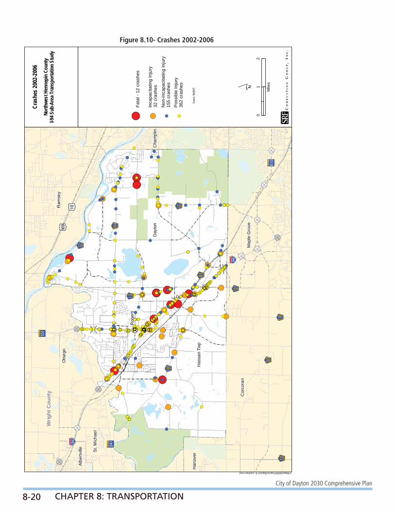
CRASHESThe safety of the roadway network is a high priority for the study partners, as well as for agencies that are responsible for improving and maintaining transportation facilities. To evaluate potential safety problems within the study area, a planning level crash analysis was performed using MnDOT’s Crash Mapping Analysis Tool (MnCMAT). This dataset was reviewed to identify the number, location, and severity of crashes in the Cities of Dayton and Rogers, along with Hassan Township for the years 2002 - 2006. Overall there were 1,760 crashes, of which 12 involved fatalities, 548 involved personal injury and 1,200 involved property damage (Table 8.5 – Motor Vehicle Crashes in the Cities of Dayton, Rogers, and Hassan Township, 2002 - 2006). Figure 8.10 – Crashes, 2002 - 2006 illustrates the injury and fatal crashes within the study area during this time period.

8-18
City of Dayton 2030 Comprehensive Plan
CHAPTER 8: TRANSPORTATION
NORTH
North
07
60
59
De
ce
mb
er
20
07
Nor
thw
est H
enne
pin
Cou
nty
Stu
dyH
enne
pin
Cou
nty
Leg
en
d
=A
cc
ep
tab
le O
pe
ratio
ns
=U
na
cc
ep
tab
le O
pe
ratio
ns
=Q
ue
uin
g P
rob
lem
s d
urin
g
S
cho
ol P
ea
k
Exi
stin
g A
.M. L
evel
of
Ser
vice
Fig
ure
2-6
H:\Projects\6059\TS\Figures\Fig 7_AM LOS.cdrFigure 8.8- Existing A.M. Level of Service

8-19
City of Dayton 2030 Comprehensive Plan
CHAPTER 8: TRANSPORTATION
NORTH
North
07
60
59
De
ce
mb
er
20
07
Nor
thw
est H
enne
pin
Cou
nty
Stu
dyH
enne
pin
Cou
nty
Leg
en
d
=A
cc
ep
tab
le O
pe
ratio
ns
=U
na
cc
ep
tab
le O
pe
ratio
ns
=Q
ue
uin
g P
rob
lem
s d
urin
g
S
cho
ol P
ea
k
Exi
stin
g P
.M. L
evel
of
Ser
vice
Fig
ure
2-7
H:\Projects\6059\TS\Figures\Fig 8_PM LOS.cdr
Figure 8.9- Existing P.M. Level of Service
8-20
City of Dayton 2030 Comprehensive Plan
CHAPTER 8: TRANSPORTATION
!
!!
!
!
!
!
!
! !
!
!
(
((
(
(
(
(
(
( (
(
(
!!
!!
!
!!
!
!
!!
!
!
!
!
!
!
!
!
!
!
!
!
!
!!
!
!
!!
!
!
((
((
(
((
(
(
((
(
(
(
(
(
(
(
(
(
(
(
(
(
((
(
(
((
(
(
!
!
!
!
!
! !
!
!
!
!
!
!!
!
!
!
!
!
!
!
!
!
!! ! !
!!
!
!
!!!
!
!
!
!
!
!
!
!
!
!
!
!
!
!
!
!
! !
!
!
!
!
!!!
!
!
!
!
!
! !!
!
!!
!
!
!
!
!
!
!
!
!
!
!
!
!
! !
!
!
!
!
!!
!
!
!
!
! !
!
!
!
!
!
!
!
!
!
!!
!
!
!
!
!
!
!!
!
!
!
!!
!
!
!
!!!
!
! !
!
!!
!
! ! !
!
!
!
!
!
!!
!
!
!!
!
!!!
!
!
!
(
(
(
(
(
( (
(
(
(
(
(
((
(
(
(
(
(
(
(
(
(
(( ( (
((
(
(
(((
(
(
(
(
(
(
(
(
(
(
(
(
(
(
(
(
( (
(
(
(
(
(((
(
(
(
(
(
( ((
(
((
(
(
(
(
(
(
(
(
(
(
(
(
(
( (
(
(
(
(
((
(
(
(
(
( (
(
(
(
(
(
(
(
(
(
((
(
(
(
(
(
(
((
(
(
(
((
(
(
(
(((
(
( (
(
((
(
( ( (
(
(
(
(
(
((
(
(
((
(
(((
(
(
(
!!!
!
!
!
!
!
!
!
!
!
!
!
!
!
!
!
!
!
!
!
!
! !!! !
!
!! !
!
!
!
!
!
!
!
!
!
!
!
!
!
!
!
!
!
!
!
!
!
!! !!!
!
! !! !!!! ! ! !!
!
!
!
!
!
!! !
!
!!
! !!
!
!
!
!!
!
!!
!
!
!
!
!! !!
!
!
!
!!
!
!
!
!
!
!
!
!!!
!!!
!
!!
!
!
!
!
!
!
!
!! !!
!
!
!
!!
!
!
!
!
!
!
!
!!
!
!
!
!
!
!
!
!
!
! !!
!
!
!
!
!
!
!
!
!
!
!
!
!
!
!
!
!
!
! !!
!
!
!!
!
!
!
!!
!
!
!
!
!
!
!
!
!
!
!
!
!
!
!
!
!
!
!! !!
!
!
!
!!
!
!
!
!
!
!
!
!
!!! !
!
!
!
! !
!
!
!
!
!!
!
!
!
!!
!
!
!
! !
!
! !! !
!!
!
!
!!!! !
!
!
!!
!
!!
!
! !!
!
!
!
!
! !
!
!
!
!
!!
!
!
!
!
!
!
! !!
!
!
!
!
! !
!
!
!
!!
!
!
!
!
!
!
!
!!
!
!
!
!
!!!
!
!
!
!
!
!!!!!
!
!
!
!
!
!
!
!
!
!!
!!
!! !
!
!
!
!
!
!
!
!
!
!
!!
!
!
! (((
(
(
(
(
(
(
(
(
(
(
(
(
(
(
(
(
(
(
(
(
( ((( (
(
(( (
(
(
(
(
(
(
(
(
(
(
(
(
(
(
(
(
(
(
(
(
(
(( (((
(
( (( (((( ( ( ((
(
(
(
(
(
(( (
(
((
( ((
(
(
(
((
(
((
(
(
(
(
(( ((
(
(
(
((
(
(
(
(
(
(
(
(((
(((
(
((
(
(
(
(
(
(
(
(( ((
(
(
(
((
(
(
(
(
(
(
(
((
(
(
(
(
(
(
(
(
(
( ((
(
(
(
(
(
(
(
(
(
(
(
(
(
(
(
(
(
(
( ((
(
(
((
(
(
(
((
(
(
(
(
(
(
(
(
(
(
(
(
(
(
(
(
(
(
(( ((
(
(
(
((
(
(
(
(
(
(
(
(
((( (
(
(
(
( (
(
(
(
(
((
(
(
(
( (
(
(
(
( (
(
( (( (
((
(
(
(((( (
(
(
((
(
((
(
( ((
(
(
(
(
( (
(
(
(
(
((
(
(
(
(
(
(
( ((
(
(
(
(
( (
(
(
(
((
(
(
(
(
(
(
(
((
(
(
(
(
(((
(
(
(
(
(
(((((
(
(
(
(
(
(
(
(
(
((
((
(( (
(
(
(
(
(
(
(
(
(
(
((
(
(
(
!"b$
!"b$)y
)m
?ûA@
?²A@
GïWX
GlWX
GÛWX
GöWX
GiWX
G÷WX
G¢WX
GkWX
Gÿ³4 WX
GöWX
Day
ton
Rog
ers
Has
san
Twp
Cor
cora
n
Alb
ertv
ille
Map
le G
rove
Ots
ego
St. M
icha
el
Ram
sey
Wrig
ht C
ount
y
?óA@
Han
over
Cha
mpl
in
Cras
hes 2
002-
2006
Figu
re 2-
8
´0
12
Mile
s
! (Fa
tal -
12
cras
hes
!(In
capa
cita
ting
Inju
ry32
cra
shes
! (N
on-In
capa
cita
ting
Inju
ry15
5 cr
ashe
s
! (P
ossi
ble
Inju
ry36
2 cr
ashe
s
North
west
Hen
nepi
n Co
unty
I-94 S
ub-A
rea T
rans
porta
tion
Stud
y
Sour
ce: M
n/DOT
J:\Maps\6059\Figures\figure2-8_crashes.mxdFigure 8.10- Crashes 2002-2006

8-21
City of Dayton 2030 Comprehensive Plan
CHAPTER 8: TRANSPORTATION
Table 8.4- Motor Vehicle Crashes in theCities of Dayton, Rogers and Hassan Township, 2002-2006
It should be noted there is a high correlation between the frequency of crashes and traffi c volumes, as well as a correlation between crashes and confl ict points (access). In general, roadways with higher volumes are expected to have more total crashes than a lower volume roadway. Based on reviewing crash locations maps, observations were made that there are several areas were there were higher crash frequencies.
In keeping with the state’s goal of “Toward Zero Deaths,” additional analysis of the fatal crashes within Dayton, Rogers, and Hassan Township over the fi ve-year study period was also conducted. Based on the crash reports, roadway geometry was not cited as contributing factors in the fatal crashes. Instead, the reports showed the following:
• Three of the 12 fatal crashes (25%) occurred on I-94, and another three took place on Brockton Lane (CSAH 13). South Diamond Lake Road (CSAH 144) accounted for two fatal crashes, as did Industrial Boulevard (CSAH 81). Finally, both Dayton River Road (CSAH 12) and Territorial Road (CSAH 116) accounted for one fatal crash.
• All of the fatal crashes took place on roadways where the posted speed limit was 45 mph or greater.
• Nine of the 12 fatal crashes (75%) involved two vehicle crashes.
• Six of the 12 fatal crashes (50%) took place on either Friday or Saturday.
• Fifty-four percent of the drivers involved in a fatal crash were under the age of 30.
• Seventy-six percent of the drivers involved in a fatal crash were male.
• One fatality involved a driver who had been drinking.
MULTIMODAL TRANSPORTATION ELEMENTSThe transportation system is made up of various elements. These include trucking, railroads, transit, aviation, and bicycle/pedestrians. The existing multimodal elements are summarized below.

8-22
City of Dayton 2030 Comprehensive Plan
CHAPTER 8: TRANSPORTATION
TruckingInterstate 94 is one of the major sources of trucking movements in the state. Year 2006’s Heavy Commercial Average Daily Traffi c (HCADT) volumes obtained from MnDOT show that approximately 10 percent of the traffi c along I-94 in the study area is heavy commercial vehicles (7,310 heavy vehicles out of 73,000 vehicles per day). Generally, trucks using I-94 primarily travel through the area and are a consideration with respect to operational and access issues on I-94.
The City of Dayton is making signifi cant strides in its land use plan to increase opportunities for business park and industrial growth. The main issue in meeting this goal is to have access to I-94 at Brockton Lane. New business, especially the level at which Dayton desires to provide to meet the large increase in population and household growth, needs this improved access and visibility.
RailroadsThe Burlington Northern Santa Fe (BNSF) railroad passes through the southwest corner of Dayton.
TransitLimited transit services are available in the study area which is outside of the Metropolitan Transit Taxing District. The Metropolitan Council designated the majority of the study area as part of Transit Market Area IV and is in the area of a potential transit service expansion. Service options for Market Area IV include dial-a-ride, volunteer driver programs, ridesharing, peak-only express routes, mid-day circulators, and special needs paratransit. The eastern portion of Dayton is in Market Area III which includes service options such as peak-only express routes, small vehicle circulators, special needs para-transit (ADA, seniors), ridesharing, and van pooling.
There is currently no regular route transit services provided in the study area. Dial-a-ride service for seniors and persons with disabilities is provided by Senior Transportation Program (STP) in Dayton and Rogers. STP is a community based Dial-a-Ride system that provides general public, handicapped-accessible service to these areas as well as the Cities of Champlin, Maple Grove, Osseo, and Brooklyn Center. It operates with four accessible small buses,
Monday through Friday from 8:00 a.m. to 4:30 p.m. This system allows access to the regional regular route network through connections with Maple Grove Transit in Maple Grove and Metro Transit routes in Brooklyn Center.
Transitway expansion is being studied for improved transit service to the area. In particular, the Bottineau Boulevard (formerly Northwest Transitway) project identifi ed in the Metropolitan Council’s 2030 Transportation Policy Plan would provide express service to downtown Minneapolis along the CSAH 81 and Burlington Northern Santa Fe Railway corridor using a rapid mass transit mode such as Bus Rapid Transit, Light Rail Transit, or commuter rail. Hennepin County and the Metropolitan Council are cooperating on determining the most effective means to implement new service on this corridor to meet future transportation demand and address growing congestion.
AviationThere are no airports or heliports within the study area; however, the airspace over Dayton, Rogers, and Hassan Township is used by aircraft operating from metropolitan area airports and other airports. The three closest airports are in Blaine, Crystal, and Buffalo. These general aviation airports primarily serve private air services, recreational aviation, and charters. The vast majority of passenger and freight air service provided to residents in the study area is located at the Minneapolis/St. Paul International Airport (MSP).
In the Metropolitan Council’s Aviation Policy Plan (last adopted in 1996), the northwestern section of Hennepin County is identifi ed as “General Aviation Search Area A.” A new reliever airport is recommended in this search area as a way to improve capacity and resolve operational defi ciencies projected for Anoka County-Blaine, Crystal, and Flying Cloud Airports. The majority of the study area falls within this search area.
Although there are no aviation facilities in the study area according to both Federal Aviation Administration (FAA) and MnDOT Aeronautics safety standards any applicant who proposes to construct a structure 200 feet above the ground level must

8-23
City of Dayton 2030 Comprehensive Plan
CHAPTER 8: TRANSPORTATION
get appropriate approval. The Federal Aviation Administration requires the FAA Form 7460-1 “Notice of Proposed Construction or Alteration,” under code of federal regulations CFR-Part 77, to be fi led for any proposed structure or alteration that exceeds 200 feet. FAA Form 7460-1 can be obtained from FAA headquarters and regional offi ces.
These forms must be submitted 30 days before alteration/construction begins or the construction permit is fi led whichever is earlier. MnDOT must also be notifi ed (MnDOT Rules Chapter 8800). The MSP airport/community zoning board’s land use safety zoning ordinance should also be considered when reviewing construction in the City that raises potential aviation confl icts.
Dayton, Rogers, and Hassan Township have no existing structures over 200 feet in height, do not permit such structures under their zoning ordinances, and have no plans to permit such structures in the future.
Several bodies of water in the study area are designated in Minnesota State Rules Chapter 8800.2800 as authorized for purposes of safe sea plane use. These include Diamond Lake (Dayton), French Lake (Dayton) and the Mississippi River. The operation of seaplanes on these waters must conform to all applicable marine traffi c rules and regulations.
Bicycle/PedestriansThe Parks, Trail and Open Space Plan (Appendix B) recently completed by the City serves as Chapter 7 – Parks, Trails, and Open Space of the Comprehensive Plan. This plan identifi es an extensive system of pedestrian and bicycle trails throughout the City. The plan incorporates trails that are designed to be adjacent but separated from roadways as well as independent corridor trails. Both of these types can include bituminous options to support bicycles. In addition, connection trails are planned to provide connections between neighborhoods, parks, community destinations, and the city-wide trail system. The City will implement this plan and development of this trail system through park and trail dedications as development occurs.
In addition to the City’s plan, the Three Rivers Park
District is currently working on the Rush Creek Regional Trail Master Plan. The purpose of this Master Plan is to identify a route for the future Rush Creek Regional Trail that will connect the Crow-Hassan Park Reserve to the Elm Creek Park Reserve. Although still a concept, the proposed alignment of the trail travels from the Crow-Hassan Park Reserve through Hassan Township, along the borders of Maple Grove and Dayton to its connection to the Elm Creek Park Reserve. A draft of the Master Plan was released for community review in March 2008.
ROADWAY SYSTEM PLANFunctional Classifi cationRoadway functional classifi cation categories area defi ned by the role they play in serving the fl ow of trips through the overall roadway system. Table 8.5 – Roadway Functional Classifi cation Criteria illustrates the Metropolitan Council’s detailed criteria for the functional classifi cation of roadways within the Twin Cities Metropolitan Area.
The intent of the functional classifi cation system is to create a hierarchy of roads that collect and distribute traffi c from neighborhoods to the metropolitan highway system. Roadways with a higher functional classifi cation (arterials) generally provide for longer trips, have more mobility, have limited access, and connect larger centers. Roadways with a lower functional classifi cation (collectors and local streets) generally provide for shorter trips, have lower mobility, have more access, and connect to higher functioning roadways. A balance of all functions of roadways is important to any transportation network. Figure 8.12 – Access/Mobility Relationship depicts the relationship of the various functional classifi cations to access and mobility.
Each community adopted an existing functional classifi cation plan as part of their last comprehensive plan update. The existing functional classifi cation plan for the communities within the study area is shown in Figure 8.13 – Existing Roadway Functional Classifi cation. This plan refl ects the functional classifi cation systems adopted by the Metropolitan Council for this area. The functional classifi cation plans were established assuming some urbanization within existing cities but not nearly the degree of long-term growth that is anticipated under this 2030 plan.

8-24
City of Dayton 2030 Comprehensive Plan
CHAPTER 8: TRANSPORTATION
Table 8.5- Roadway Functional Classifi cation Criteria
Figure 8.11- Access/Mobility Relationship

8-25
City of Dayton 2030 Comprehensive Plan
CHAPTER 8: TRANSPORTATION
Minor ArterialsThe minor arterial roadways play an important role in the study area by connecting population centers to one another, connecting centers to other areas in the county, and connecting centers to the roadway system. There are three A Minor Connector roadways within the Dayton:
• CSAH 13 (I-94 to CSAH 12)
• CSAH 12 (CSAH 36 to eastern study boundary)
• CSAH 81 (CSAH 150 to eastern study boundary)
The one B Minor Arterials in Dayton includes CSAH 144 (CSAH 16 to CSAH 12).
CollectorsThe collector system connects local roads to the minor arterial system. Unlike the principal and minor arterial systems, which emphasize mobility, the collector system places an equal emphasis on both mobility and access. In general, this means that there are more driveways and public street accesses to the collector system than there are to the minor and principal arterial systems.

8-26
City of Dayton 2030 Comprehensive Plan
CHAPTER 8: TRANSPORTATION
!"b$
!"b$)y
)m
?ûA@
?²A@
GïWX
GlWX
GÛWX
GöWX
GiWX
G÷WX
G¢WX
GkWX
Gÿ³4 WX
GöWX
Day
ton
Rog
ers
Has
san
Twp
Cor
cora
n
Alb
ertv
ille
Map
le G
rove
Ots
ego
St. M
icha
el
Ram
sey
Wrig
ht C
ount
y
?óA@
Han
over
Cha
mpl
in
Exist
ing
Road
way
Func
tiona
l Clas
sifica
tion
Figu
re 3-
2
´0
12
Mile
s
Prin
cipa
l Arte
rial
A M
inor
Aug
men
tor
A M
inor
Rel
ieve
r
A M
inor
Exp
ande
r
A M
inor
Con
nect
or
B M
inor
Maj
or C
olle
ctor
Min
or C
olle
ctor
Pot
entia
l Fut
ure
Roa
dway
Alig
nmen
ts
Inte
rcha
nges
! ?E
xist
ing
! ?P
oten
tial F
utur
e
North
west
Hen
nepi
n Co
unty
I-94 S
ub-A
rea T
rans
porta
tion
Stud
y
Sour
ce: M
et C
ounc
il
J:\Maps\6059\Figures\figure3-2_EFC.mxd
Figure 8.12- Existing Roadway Functional Classifi cation

8-27
City of Dayton 2030 Comprehensive Plan
CHAPTER 8: TRANSPORTATION
FUTURE FUNCTIONAL CLASSIFICATION
A key element of this study involved creating a future functional classifi cation plan for roadways in the study area. According to each of the communities’ land use plans, the study area is expected to continue to urbanize and portions of the area will eventually be urbanized to a point similar to the present Cities of Plymouth and Maple Grove. This urbanization will add more people and traffi c to the study area and the existing functional classifi cation plan will not be able to handle this growth. Therefore, an integrated roadway network with a closer spacing of minor arterial and collector routes was designed as part of the future functional classifi cation plan to serve future growth patterns in the study area. Another goal of the future functional classifi cation plan was to improve mobility and continuity of the transportation system in the study area. This was achieved by improving access to I-94, providing connections across I-94, and improving continuous north-south and east-west roadway connections in the study area.
In addition to this, there are a number of signifi cant physical barriers that restrict traffi c movements in the area. The presence of several large lakes, wetlands, and environmentally sensitive areas as well as the Elm Creek Park Reserve make direct route connections diffi cult. This is especially true of east-west routes in the City of Dayton. In addition, the Mississippi River is a barrier to continuous north-south travel. The Crow River, located along the western border of the study area, has been noted as a barrier to east-west travel. Both these rivers serve to concentrate traffi c at current river crossings which leads to congestion on existing routes. There have been extensive discussions and studies on the future Dayton-Ramsey river crossing; however, environmental documentation is not complete for this potential north/south route. Because this is beyond 2030, this connection is not shown on the future functional classifi cation system. No recommendations were made from the analysis and the issue remains unresolved.
The following guidelines were considered in developing the future functional classifi cation plan.
• Study area communities’ land use plans assume continued urbanization by 2030; therefore, urban spacing criteria was used to identify proper spacing of routes to achieve a balanced distribution of traffi c (need to provide access and mobility functions for entire area).
• Ability of the route to provide continuity through individual travelsheds or between travelsheds, including connectivity to freeway and/or IRC access location.
• Ability of the route to serve regional population centers, regional activity centers, and major traffi c generators.
• Relationship of the route to adjacent land uses (location of growth areas, industrial areas, and neighborhoods).
• Trip length characteristics of the route as indicated by route length, type and size of traffi c generators served, and route continuity.
• Ability of the route to provide mobility or land access function based on the number of accesses, access spacing, speed, parking, and traffi c control.
Using these guidelines, the study partners recommended a closer spacing for arterial and collector systems to serve future growth patterns in the study area. The future functional classifi cation map shows appropriate location and spacing of future arterial and collector facilities (Figure 8.13 – Future Functional Classifi cation). This fi gure depicts the entire study area while the specifi c plans for Dayton will be discussed below. The focus of this future system planning was at the minor arterial level. Study partners provided information on the collector and local road systems of this plan. The changes to the roadway system represent a desire to achieve a better arterial grid system, and promote the use of local arterials for shorter inter-city type trips. The key changes to the system for the City of Dayton are described in Table 8.6 – Functional Classifi cation Change Map Reference Description.

8-28
City of Dayton 2030 Comprehensive Plan
CHAPTER 8: TRANSPORTATION
Table 8.6- Functional Classifi cation Change Map Reference Description

8-29
City of Dayton 2030 Comprehensive Plan
CHAPTER 8: TRANSPORTATION
Figure 8.13- Future Functional Classifi cation

8-30
City of Dayton 2030 Comprehensive Plan
CHAPTER 8: TRANSPORTATION
The arterial and collector systems shown in the future system plan are not all of the roadways needed. These are just the key facilities. Frontage or backage roadways will be needed to attain desired access spacing on the key facilities. Study partners should use the future system plan when making decisions and recommendations for proposed developments.
FUTURE INTERCHANGESThe development of a future roadway system in the study area included a discussion of a potential I-94 interchange access between TH 101 and CSAH 30. Access to I-94 was identifi ed as an issue for the study area since currently the only existing access to I-94 is at TH 101 and CSAH 30. This leaves approximately six miles without interchange access to I-94 in this area (Figure 8.14 – Existing Interchange Spacing). As northwest Hennepin County continues to urbanize, access to the Interstate may be necessary to relieve current access points. TH 101 interchange is currently experiencing operational issues. Additional access to I-94 will better balance fl ows to and from these regional system access points. In addition, developing a unifi ed plan for access to I-94 is important to communities as they develop their land use and transportation plans. Knowing whether additional access to I-94 is possible is signifi cant in planning the future roadway and land uses in the area (i.e., if additional access is not warranted, local system and/or land use changes may need be altered).
To address the issue of additional access to I-94, the study partners undertook the study of various alternatives including no-build: a) local system improvements, b) local system improvements plus regional highway expansion, and c) local system improvements, regional highway expansion and additional interchange access to I-94 at Brockton Lane (CSAH 101). Although only one interchange location is identifi ed in the future systems plan, the study partners chose this general location from a comprehensive viewpoint of the entire study area. Brockton Lane is located approximately half way between TH 101 and CSAH 30 along I-94. In addition, Brockton Lane is a logical location for a future interchange due to the existing and future urbanization of Dayton and Hassan Township. Its proximity to these growing areas will help by providing
access to I-94 in this area, rather than forcing these trips to the existing interchanges at TH 101 and CSAH 30. The analysis of a potential additional access to I-94 at Brockton Lane was reviewed in terms of consistency with the Metropolitan Council’s Planning Criteria and the Federal Highway Administration’s Interstate Access Criteria.
Dayton’s 2001 Comprehensive Plan identifi ed an interchange at Brockton Lane/I-94. A Qualifying Criteria was completed and included in Dayton’s 2001 Comprehensive Plan. MnDOT provided a review of the Qualifying Criteria dated July 15, 1999. The 2008 land use plan also provides for an interchange in the vicinity of Brocton Lane/I-94. Dayton is very supportive of an interchange at Brockton Lane/I-94.

8-31
City of Dayton 2030 Comprehensive Plan
CHAPTER 8: TRANSPORTATION
Gra
phic
s S
uppo
rt/
6059
Nor
thw
est
Hen
nepi
n C
o S
ub A
rea
Stu
dy I
I/ fig
ures
/ver
t fig
ures
.qxd
Figure 3-4
Crow-HassanPark
Elm Creek
Mississippi West Park
M
DAYTON
HASSAN TOWNSHIP
ST. MICHAEL
ROGERS
RAMSE
ER
CORCORAN
LLE
144
116
150
49
13
13
42
37
36
121
12
50
10
19
8130
109
10
10
101
116
10
MINNESOTA
101
56COUNTY
ROAD
159COUNTY
ROAD
117COUNTY
ROAD
203COUNTY
ROAD
5OUNTY
ROAD
94
94
94
94
94
94
81
2.5 miles
6 miles
2 miles0 1 2
Miles
N
Existing Interchange SpacingNorthwest Hennepin County I-94 Sub-Area Transportation StudyCities of Dayton, Rogers, Hassan Township
6059026J78012308
LEGEND
94 Overpasses
River Crossings
Railroads
Transportation
Interregional Corridors
Major Roadway
Minor Roadway
Existing Interchanges
Future interchanges
Planned future roads
Parks
Natural Features
Figure 8.14- Existing Interchange Spacing

8-32
City of Dayton 2030 Comprehensive Plan
CHAPTER 8: TRANSPORTATION
JURISDICTION
Existing JurisdictionA number of different agencies are responsible for transportation facilities in the study area. The Minnesota Department of Transportation (MnDOT) maintains state highways which include the interstate system and other Trunk Highways (TH). Hennepin County maintains the County State Aid Highway (CSAH) system and County Roads (CR). The remaining local roads are maintained by the Cities of Rogers and Dayton and Hassan Township and other adjacent local jurisdictions. The existing jurisdictional classifi cation is shown in Figure 8.15 – Existing Roadway Jurisdiction. There are four County State Aid Highway System roadways in Dayton.
The jurisdictional classifi cation system is intended to maintain a balance of responsibility among the agencies. It is organized around the principle that the highest volume limited access roadways that carry longer regional trips are primarily maintained by MnDOT (Principal Arterials and some Minor Arterials); the intermediate volume roadways that carry medium length trips are typically maintained by the County (minor arterials): and the local street system that provides access to individual properties is maintained by the City (collectors and local roadways).
Jurisdictional ChangesAfter the development of the future functional classifi cation plan, the existing roadway jurisdiction was reviewed and candidates for potential jurisdictional transfers were identifi ed. Roadway jurisdiction is an important element because it affects a number of critical organizational functions and obligations (regulatory, maintenance, construction, and fi nancial). The primary goal in reviewing jurisdiction is to match the function of the roadway with the organization level that is best suited to manage the roadway.
The jurisdiction process used to identify jurisdictional transfer candidates is outlined as follows:
• A functional classifi cation plan was developed for the study area.
• Jurisdictional transfer candidates were identifi ed by evaluating roadways in the study area against the jurisdictional guidelines.
• Jurisdictional transfer candidates were rated according to how well they met the jurisdictional transfer guidelines. These rankings and their rationale were discussed with the partners. The transfer ratings were defi ned as follows:
Rating 1: Transfer candidate defi nitely meets transfer guidelines.
Rating 2: Transfer candidate substantially meets transfer guidelines.
Rating 3: Transfer candidate marginally meets transfer guidelines or the transfer candidate is dependent on future growth and development of area.
Rating 4: Transfer candidate does not meet transfer guidelines and therefore is not recommended as a future transfer.
Based on the personal potential jurisdictional transfers discussed by the partners, a summary of the mileage impacts for each jurisdiction was developed.

8-33
City of Dayton 2030 Comprehensive Plan
CHAPTER 8: TRANSPORTATION
!"b$
!"b$)y
)m
?ûA@
?²A@
GïWX
GlWX
GÛWX
GöWX
GiWX
G÷WX
G¢WX
GkWX
Gÿ³4 WX
GöWX
Day
ton
Rog
ers
Has
san
Twp
Cor
cora
n
Alb
ertv
ille
Map
le G
rove
Ots
ego
St. M
icha
el
Ram
sey
Wrig
ht C
ount
y
?óA@
Han
over
Cha
mpl
in
Exist
ing
Road
way J
urisd
ictio
n
Figu
re 3-
5
´0
12
Mile
s
Inte
rsta
te
US
Hig
hway
Stat
e H
ighw
ay
CS
AH
MSA
S
Cou
nty
Roa
d
Tow
nshi
p R
oad
Mun
icip
al S
treet
Park
Roa
d
Priv
ate
Juris
dict
ion
Roa
d
Ram
p
Pote
ntia
l Fut
ure
Roa
dway
Alig
nmen
ts
Inte
rcha
nges
! ?Ex
istin
g
! ?Po
tent
ial F
utur
e
North
west
Hen
nepi
n Co
unty
I-94 S
ub-A
rea T
rans
porta
tion
Stud
y
Sour
ce: M
n/DOT
J:\Maps\6059\Figures\figure3-5_jurisdiction.mxdFigure 8.15- Existing Roadway Jurisdiction

8-34
City of Dayton 2030 Comprehensive Plan
CHAPTER 8: TRANSPORTATION
Candidates for potential jurisdictional changes were divided into the following categories and are illustrated in Figure 8.16 – Potential Jurisdictional Changes.
Jurisdictional Transfers from County to CitiesPotential roadway candidates for transfer from county to city jurisdiction include roadways that no longer provide direct connections between major areas of the county, have been replaced by other county or state roads, or are simply redundant as county roads. Most of the roads identifi ed for transfer are relatively short in length and their primary function is to provide local access. The recommendations for transfers from Hennepin County to the City of Dayton include CSAH 121 (French Lake Road) (north-south section in eastern Dayton)
A part of CSAH 121 (north-south section) or French Lake Road (in eastern Dayton) is recommended to be turned from county to City jurisdiction due to the proposed realignment of CSAH 121 to connect to CSAH 12 and CSAH 144 to the north and CSAH 121 westerly to CSAH 81. The existing north-south section between 125th Avenue and CSAH 144 is presently Zanzibar Lane and abuts the western edge of Elm Creek Park Reserve.
Jurisdictional Transfers from Cities to CountyTwo roadways currently under City jurisdiction were identifi ed as facilities that will provide direct connections between major areas in the county and connect areas where county routes do not currently exist. Roadways of this nature are recommended as potential candidates for transfer from city jurisdiction to county jurisdiction.
• Zanzibar Lane is recommended to be transferred from city to county jurisdiction due to the proposed future extension of this roadway to connect CSAH 12 and I-94 at the Maple Grove Parkway interchange. This extension will provide an important north-south connection through central Dayton serving as an alternate route to CSAH 13. This roadway is recommended for future county jurisdiction due to its length,
connecting a county facility to I-94, and its spacing from CSAH 13 as another north-south county facility through this northwestern part of Hennepin County within the City of Dayton.
• Pineview Lane is recommended to be transferred from city to county jurisdiction due to its future A Minor Functional Classifi cation from CSAH 121 to CSAH 144. This roadway section is also recommended for transfer due to its connection to CSAH 144/12, its spacing from TH 169, and the future extension of CSAH 121 north-south to CSAH 144/12 abutting the western edge of Elm Creek Park Reserve.
Jurisdictional Transfers from State to CountyThere are no facilities in the primary study area that are recommended as turnbacks from the state to the county.

8-35
City of Dayton 2030 Comprehensive Plan
CHAPTER 8: TRANSPORTATION
!"b$
!"b$)y
)m
?ûA@
?²A@
GïWX
GlWX
GÛWX
GöWX
GiWX
G÷WX
G¢WX
GkWX
Gÿ³4 WX
GöWX
Day
ton
Rog
ers
Has
san
Twp
Cor
cora
n
Alb
ertv
ille
Map
le G
rove
Ots
ego
St. M
icha
el
Ram
sey
Wrig
ht C
ount
y
?óA@
Han
over
Cha
mpl
in
Pote
ntial
Juris
dict
iona
l Cha
nges
Figu
re 3-
6
´0
12
Mile
s
Mn/
DO
T to
Cou
nty
City
to C
ount
y
Cou
nty
to C
ity
Mn/
DO
T N
ew R
oute
Ext
ensi
on
Cou
nty
New
Rou
te E
xten
sion
Loca
l New
Rou
te E
xten
sion
Inte
rcha
nges
! ?E
xist
ing
! ?Po
tent
ial F
utur
e
North
west
Hen
nepi
n Co
unty
I-94 S
ub-A
rea T
rans
porta
tion
Stud
y
The
juris
dict
iona
l ide
as re
pres
ente
din
this
pla
n ar
e pr
esen
ted
for f
utur
eco
nsid
erat
ion
by th
e re
spec
tive
juris
dict
ions
. Th
e de
pict
ion
of ro
utes
for j
uris
dict
iona
l cha
nge
does
not
impl
y an
y ac
cept
ance
or a
gree
men
tsfo
r thi
s ch
ange
.
J:\Maps\6059\Figures\figure3-6_jurisdiction_changes.mxd
Figure 8.16- Potential Jurisdictional Changes

8-36
City of Dayton 2030 Comprehensive Plan
CHAPTER 8: TRANSPORTATION
ANALYSIS OF FUTURE TRANSPORTATION NEEDS
Traffi c ForecastsTraffi c forecasts for the year 2030 were prepared for the sub-area study to identify future capacity defi ciencies and to provide traffi c information that will assist state, county and city staff, and offi cials in making important transportation decisions. The traffi c forecasts for this study were built on the previous forecasting work for the I-494 Environmental Assessment. This work used the Metropolitan Council’s regional transportation model. This large regional model was further refi ned to include more detailed Traffi c Assignment Zone (TAZ) breaks throughout the study area, revised demographic assumptions, and a refi ned local arterial and collector network.
Capacity/Issue AreasExisting capacity issues/defi ciencies within the study area were reviewed in Section 2.0 of this report. Figure 8.8 – Existing A.M. Level of Service and Figure 8.9 – Existing P.M. Level of Service identifi ed capacity/operations issues in the a.m. and p.m. peak hours at several locations by highlighting intersections/segments with unacceptable operations. The primary areas of congestion include the regional facilities of I-94 and TH 101 and other isolated intersections where growth has exceeded intersection capacities.
An analysis was also done to identify future transportation capacity defi ciencies. This information is normally used to either plan additional capacity improvements or to manage facilities more effectively through access controls, right-of-way preservation, setback requirements, and/or land use and development controls. Year 2030 peak hour traffi c volumes derived from the model for the No-Build Condition were compared with the daily volume thresholds and the existing number of lanes on roadways within the study area (Figure 8.17 – Existing Number of Lanes).
The analysis showed that if population and employment changes occur as projected in this area without additional transportation improvements, several roadways will become congested (Figure 8.19 – 2030 Congestion – No Build). These key congested facilities that are in Dayton include:
• CSAH 144 from CSAH 13 to TH 101,
• CSAH 13 from CSAH 144 to I-94,
• CSAH 101 from I-94 to CSAH 30,
• CSAH 81 from CSAH 150 to CSAH 121,
• Industrial Boulevard from Hynes Drive to CSAH 150,
• CSAH 121 from 125th Avenue North to CSAH 81, and
• Territorial Road from CSAH 116 to CSAH 101.

8-37
City of Dayton 2030 Comprehensive Plan
CHAPTER 8: TRANSPORTATION
!"b$
!"b$)y
)m
?ûA@
?²A@
GïWX
GlWX
GÛWX
GöWX
GiWX
G÷WX
G¢WX
GkWX
Gÿ³4 WX
GöWX
Day
ton
Rog
ers
Has
san
Twp
Cor
cora
n
Alb
ertv
ille
Map
le G
rove
Ots
ego
St. M
icha
el
Ram
sey
Wrig
ht C
ount
y
?óA@
Han
over
Cha
mpl
in
Exist
ing
Num
ber o
f Lan
es
Figu
re 4-
2
´0
12
Mile
s
Lane
s6 4 2 P
oten
tial F
utur
eR
oadw
ay A
lignm
ents
Inte
rcha
nges
! ?E
xist
ing
! ?P
oten
tial F
utur
e
North
west
Hen
nepi
n Co
unty
I-94 S
ub-A
rea T
rans
porta
tion
Stud
y
J:\Maps\6059\Figures\figure4-2_lanes.mxd
Figure 8.17- Existing Number of Lanes

8-38
City of Dayton 2030 Comprehensive Plan
CHAPTER 8: TRANSPORTATION
!"b$
!"b$)y
)m
?ûA@
?²A@
GïWX
GlWX
GÛWX
GöWX
GiWX
G÷WX
G¢WX
GkWX
Gÿ³4 WX
GöWX
Day
ton
Rog
ers
Has
san
Twp
Cor
cora
n
Alb
ertv
ille
Map
le G
rove
Ots
ego
St. M
icha
el
Ram
sey
Wrig
ht C
ount
y
?óA@
Han
over
Cha
mpl
in
2030
Con
gest
ion
- No
Build
Figu
re 4-
3
´0
12
Mile
s
Con
gest
ed S
egm
ents
Pote
ntia
l Fut
ure
Roa
dway
Alig
nmen
ts
Inte
rcha
nges
! ?Ex
istin
g
! ?Po
tent
ial F
utur
e
North
west
Hen
nepi
n Co
unty
I-94 S
ub-A
rea T
rans
porta
tion
Stud
y
J:\Maps\6059\Figures\figure4-3_2030_nobuild_congestion.mxd
Figure 8.18- 2030 Congestion- No-Build

8-39
City of Dayton 2030 Comprehensive Plan
CHAPTER 8: TRANSPORTATION
Capacity analysis is a planning level tool that identifi es potential problems based on the facility type and future volume projections. It is also important to remember that a segment may be shown as congested, but this is only an indication of potential problem. Some segments may have little to no access and relatively little cross traffi c which can result in the ability of the facility to accommodate higher volumes. As long as access remains limited, it is likely that the roadways will operate better than the analysis would indicate. While the capacity analysis identifi es potential problem areas, it is recommended that additional traffi c information be reviewed to confi rm operational problems as specifi c improvements or operational changes are being considered for implementation. This would include the evaluation of peak hour volumes, directional splits, and a review of actual development and growth patterns for the area.
Following the analysis of the future No-Build condition, additional modifi cations were made to the study network to analyze different system network scenarios (alternatives) including additional access to I-94 and their resulting traffi c impacts to the local system (ability to better distribute volumes, and overall effi ciency of system [Vehicle Miles Traveled (VMT) and Vehicle Hours of Travel (VHT)]. These alternatives are discussed in detail in the following section..
INTERCHANGE ALTERNATIVE ANALYSISThe primary goal of the sub-area study was to identify a long-term transportation system plan that provides a solid framework for future growth of the area as well as maintaining mobility and safety of the transportation system. An arterial system plan was developed to promote better east-west and north-south movements throughout the area. However, this system plan also needed to address potential access locations to I-94. The capacity of and access to I-94 have signifi cant impacts to the local supporting transportation system and will affect how local connections are made and planned. Local agencies including Dayton want to plan for a system that will serve their communities as well as the region. They also want to be able to proactively plan for these facilities over time. To address potential changes in interstate access, one must adhere to the Metropolitan Council’s and FHWA’s interstate access criteria. These criteria guided the alternative development and analysis process.
Description of AlternativesBased on input from the TAC members and the Metropolitan Council and FHWA criteria, four system alternatives were selected for analysis and evaluation. These alternatives are described below in Table 8.7 – System Alternatives.

8-40
City of Dayton 2030 Comprehensive Plan
CHAPTER 8: TRANSPORTATION
Table 8.7- System Alternatives
SYSTEM EVALUATION CRITERIAOnce the alternatives were identifi ed, they were evaluated in an initial screening process to assess overall traffi c changes and system-level impacts. This evaluation included many of the FHWA interstate access requirements. Prior to the evaluation, seven transportation objectives, related to I-94 access, were developed and discussed with the TAC. These objectives are listed below and support the overall transportation goals of the plan.
• Provide a good overall local supporting arterial network;
• Appropriately distribute existing and future transportation demand to the appropriate designated highway system functions (arterial, collector, local);
• Promote safety through good system planning practices and land use compatibility;
• Promote system effi ciency; and
• Maximize the effi cient operations of the freeway system (i.e., I-94).
The system alternatives must be evaluated to determine the high-level system trade-offs (i.e., advantages versus disadvantages) given the present and future conditions. Based on this, the following evaluation factors were developed to evaluate the different system alternatives in the Northwest Hennepin County I-94 Sub-Area Study area.
A. Consistency with the adopted transportation plans and/or plans under consideration,
B. Ability to minimize local trips on the freeway system (i.e., I-94),
C. Ability to maintain or improve safety,
D. Ability to reduce system overloads on supporting arterial network,
E. Ability to achieve acceptable intersection operations, and
F. Impacts to mainline I-94 capacity and operations.
G. Overall system effi ciency

8-41
City of Dayton 2030 Comprehensive Plan
CHAPTER 8: TRANSPORTATION
Information for this analysis was derived from updating Metropolitan Council’s regional transportation model with greater zone densities and land use changes that had been identifi ed by the Cities of Dayton and Rogers and Hassan Township. In addition, network modifi cations were made to include more local collector and arterial roadways. Calibration runs were made to verify accuracy of model in the study area.
The alternatives were fi rst evaluated on seven different criteria (A - G) using a rating of good, fair, or poor. The results of this analysis are summarized below.
SUMMARY OF INITIAL EVALUATIONBased upon the alternative analysis summarized above, Alternative C is recommended by the study partners as the long-term system plan for the area and supported by the City of Dayton. This system plan provides for improved system connectivity and continuity as well as balancing future demands on system linkages. An important component of this system plan is future access to I-94. While signifi cant regional modeling was done to identify system impacts of the various alternatives and their various interrelated components, fi nal approval of this access change must follow a formal Interstate Access Request (IAR). TRANSPORTATION PLAN ADOPTIONThe fi rst step in implementing the plan is for all partners to formally adopt it in principle. This means that MnDOT, Hennepin County, the Cities of Dayton and Rogers, and Hassan Township will use this study as a guide and work towards its implementation over time. As part of this adoption process, partners should integrate the key elements of the study into their comprehensive plans as the City of Dayton is doing by incorporating this study into the Transportation Chapter. Formally adopting the plan will provide the partners the basis for improved cooperation between adjacent jurisdictions, moving forward system changes (i.e., functional classifi cation jurisdiction), and setting forth improvement needs and access requirements. Necessary elements will also be included in Chapter 13 – Implementation.
SYSTEM PLAN MODIFICATIONSBased on the analysis conducted in other sections of this report, a number of changes are recommended to the existing system plan to address current and future transportation needs within the study area. The changes include modifi cations to the functional classifi cation plan and potential jurisdictional transfers. The implementation of these modifi cations is described in more detail below.
FUNCTIONAL CLASSIFICATIONA number of functional classifi cation changes are recommended as part of this study to enhance the network and accommodate future urbanization of the area. The functional classifi cation changes should be submitted as part of the community’s comprehensive plans (submittal to Metropolitan Council). If mileage limitations are encountered in this process, a staged approach should be taken with arterials in the short to mid-term growth areas being done fi rst before adding arterials in growth areas beyond the 20-year timeframe. Arterials in growth areas beyond this timeframe should be identifi ed as future arterials and added as mileage becomes available.
JURISDICTIONAL REALIGNMENT PROCESSA number of potential jurisdictional transfers have also been identifi ed as part of this study. These jurisdictional transfers are based on future functional classifi cation, system continuity, length of route, access, and future traffi c volumes. Potential jurisdictional changes will require additional discussion and negotiations by the partners over time. Typically this is done by developing a Memorandum of Understanding (MOU) outlining the negotiation process. The memorandum should address issues such as:
1. Schedule or Timeframe of Proposed Transfers:
• Non-binding schedule (goal) for the jurisdictional transfer of initial routes within the next 10 years provided that designation, maintenance, and liability issues can be worked out as outlined below.

8-42
City of Dayton 2030 Comprehensive Plan
CHAPTER 8: TRANSPORTATION
2. System Issues and Legal Requirements:
• The ability to transfer mileage to the state aid system versus local road system (e.g., Screening Board approval is needed to designate some new CSAH routes).
• The receiving agency’s ability to use funding from turnback accounts and/or other sources for maintenance and improvements.
• Further limitations on establishment, alteration, vacation, or revocation of county highways as described in Minnesota Statutes Section 163.11.
3. Planning and Programming Issues:
• The allocation of funds that will be available from the transferring agency to the receiving agency.
4. Project Development and Design and Construction Issues:
• The process for development of projects, studies, right-of-way acquisition, and design and construction of transferred routes.
• The design and construction standards to be used for projects.
• The process and framework for cost-sharing agreements.
5. Operational and Maintenance Issues:
• Responsibilities for utility permits, driveway access permits, changes to traffi c controls and signing, and level of routine regular maintenance.
ACCESS MANAGEMENTAccess guidelines are important because they defi ne a starting point for balancing property access, safety, and mobility concerns. Transportation agencies regularly receive requests for additional access (e.g., new public streets, commercial driveways, and residential and fi eld accesses), which are evaluated by numerous agencies and committees. Because
regularly receive requests for additional access (e.g., new public streets, commercial driveways, and residential and fi eld accesses), which are evaluated by numerous agencies and committees. Because of the number of individuals and agencies involved, it is easy to have inconsistent application of access policies. This can result in confusion among agencies, developers, and property owners, as well as long-term safety and mobility problems. Standard access guidelines can be used to improve communication, enhance safety, and maintain the capacity and mobility of important transportation corridors. In addition, access guidelines may be used to respond to access requests and to promote good access practices such as:
• Aligning access with other existing access points,
• Providing adequate spacing to separate and reduce confl icts, and
• Encouraging indirect access rather than direct access on high-speed, high-volume arterial routes.
Providing access management in some form, whether it is through grade-separated crossings, frontage roads, or right-in/right-out access reduces the number of confl icts resulting in improved safety. A number of studies have demonstrated a direct relationship between the number of full access points and the rate of crashes including FHWA Access Research Report No. FHWA -RD-91-044. Figure 8.19 – Access/Crash Relationship shows this relationship.
Public road authorities have been directed by Minnesota State Statues to provide “reasonable, convenient, and suitable” access to property unless these access rights have been purchased. Courts have interpreted this to:
• Allow restrictions of access to right-in/right-out and
• Allow redirection of access to another public roadway that meets the defi nition of reasonable, convenient, and suitable.

8-43
City of Dayton 2030 Comprehensive Plan
CHAPTER 8: TRANSPORTATION
In special circumstances, broader authority (police power) has been given to public agencies if the situation is deemed to jeopardize public safety. However, this is a very high standard to meet and is seldom used by public agencies.
In addition to the above, land use authorities may exercise additional authority in limiting access through their development rules and regulations. Land use authorities can require:
• Dedication of public rights-of-way,
• Construction of public roadways,
• Mitigation measures of traffi c and/or other impacts, and
• Changes in and/or development of new access points.
These types of access controls are processed through local elected offi cials (e.g., planning commissions, town boards, city councils, and county commissions).
Since stronger land use and access controls are available at the county and city level, and these units of government are usually involved at the planning stages, access guidelines and corridor management practices should be focused at this level.
Access spacing guidelines for roadways in the study area are shown in Table 8.8 – Recommend Access Spacing. Figure 8.20 – Recommended Access Spacing shows the access categories as they have been assigned to the roadway network. The access management guidelines promote coordination between land use and transportation strategies, the same issues that affect decisions on the local city and county level. Establishing the appropriate spacing between public streets and private driveways is an
Figure 8.19- Access/Crash Relationship

8-44
City of Dayton 2030 Comprehensive Plan
CHAPTER 8: TRANSPORTATION
important step toward maintaining the safety and mobility of the traveling public without sacrifi cing the accessibility needs of local residents. These guidelines were selected because they are:
• Very similar to the present policies of MnDOT and Hennepin County;
• Based on functional classifi cation rather than traffi c volumes. Having access recommendations based on future functional classifi cation enables partners to protect access on roadways based on their intended long-term function; and
• Assigned to specifi c routes (map-based), therefore eliminating any confusion about what category or access classifi cation is being used.
As with any policy, there will be a need to deal with special circumstances. The implementation of the guidelines can be done through a number of different methods (e.g., land use regulations, subdivision regulations, access permit processes, and access/transportation advisory committees). These processes should be developed so that they can deal with situations that either are outside the guidelines or are hardship cases. In existing corridors where signifi cant development has occurred, the number of existing access points are likely to exceed the access guidelines. Unless these areas are undergoing redevelopment, their access must be addressed or approached differently. The proposed access management strategy in these areas is to aggressively minimize any new accesses while consolidating/reducing existing access points as redevelopment occurs.

8-45
City of Dayton 2030 Comprehensive Plan
CHAPTER 8: TRANSPORTATION
Table 8.8- Recommended Access Spacing

8-46
City of Dayton 2030 Comprehensive Plan
CHAPTER 8: TRANSPORTATION
!"b$
!"b$)y
)m
?ûA@
?²A@
GïWX
GlWX
GÛWX
GöWX
GiWX
G÷WX
G¢WX
GkWX
Gÿ³4 WX
GöWX
Day
ton
Rog
ers
Has
san
Twp
Cor
cora
n
Alb
ertv
ille
Map
le G
rove
Ots
ego
St. M
icha
el
Ram
sey
Wrig
ht C
ount
y
?óA@
Han
over
Cha
mpl
in
Reco
mm
ende
d Ac
cess
Spa
cing
Figu
re 6-
2
´0
12
Mile
s
Hig
h Pr
iorit
y IR
Cs
1F -
Free
way
(Int
erch
ange
Acc
es O
nly)
1A -
Rur
al, E
x-ur
ban,
Byp
ass
(1 m
ile fu
ll in
ters
ectio
nsp
acin
g, 1
/2 m
ile s
econ
dary
inte
rsec
tion
spac
ing)
1A-F
- Fu
ll G
rade
Sep
arat
ion
(Inte
rcha
nge
Acce
ss O
nly)
Min
or A
rter
ials
5B -
Urb
aniz
ing
Arte
rial (
1/4
mile
full
inte
rsec
tion
spac
ing,
1/8
mile
sec
onda
ry in
ters
ectio
n sp
acin
g)
5C -
Urb
an C
ore
Arte
rial (
300-
600
feet
depe
ndin
g up
on b
lock
leng
th)
Col
lect
ors
6A -
Rur
al C
olle
ctor
(1/2
mile
full
inte
rsec
tion
spac
ing,
1/4
mile
sec
onda
ry in
ters
ectio
n sp
acin
g)
6B1
- Rur
al U
rban
zing
Col
lect
or (1
/4 m
ile fu
ll in
ters
ectio
n sp
acin
g, 1
/8 m
ile s
econ
dary
inte
rsec
tion
spac
ing)
6B2
- Loc
al C
olle
ctor
(1/8
mile
full
inte
rsec
tion
spac
ing)
6C -
Urb
an C
ore
Col
lect
or (3
00-6
00 fe
etde
pend
ing
upon
blo
ck le
ngth
)
Inte
rcha
nges
! ?Ex
istin
g
! ?Po
tent
ial F
utur
e
North
west
Hen
nepi
n Co
unty
I-94 S
ub-A
rea T
rans
porta
tion
Stud
y
J:\Maps\6059\Figures\figure6-2_access_spacing.mxdFigure 8.20- Recommended Access Spacing

8-47
City of Dayton 2030 Comprehensive Plan
CHAPTER 8: TRANSPORTATION
ACCESS SPACING FOR THE STUDY AREA ROADWAY NETWORKIn addition to establishing spacing guidelines, it is important to consider the following points when applying the guidelines and addressing access issues:
• The guidelines apply primarily to routes with a collector functional classifi cation or above; however, partners may also use the guidelines on some local streets.
• The guidelines should be used as long-term goals, not as absolute rules.
• Maintaining some fl exibility is important in promoting access consolidation.
• Approach to implementation is as important as the guidelines themselves.
• Existing physical barriers or constraints need to be considered.
The following access suggestions provide some alternatives for minimizing access and access problems in areas where the guidelines cannot be met:
• Encourage shared driveways and internal circulation plans. If indirect access cannot be achieved during plat reviews, promote internal site circulation using shared access points.
• Restrict turning movements to reduce confl icts. If access points cannot be eliminated, consider turning movement restrictions (e.g., left-in only or right-in/right-out only) through installation of raised median or other channelization or signing. Eliminating a single turning movement can signifi cantly reduce vehicle confl icts and potential crashes.
• Develop good parallel street systems for carrying local traffi c. Make sure that important arterial routes have a good parallel street system to provide the local access function and to carry shorter local trips.
• Develop proper setbacks for future frontage roads. If frontage roads cannot be justifi ed (benefi ts do not outweigh costs), make sure that proper building and parking lot setbacks are established so that future frontage roads can be installed with minimal impacts.
• Develop proper secondary street spacing. When reviewing plats and new development proposals, be sure that they provide proper intersection spacing for future signals. As a guideline, signalized intersections should be limited depending upon the type of street. Collector streets should provide some continuity and connectivity with other street systems.
• Encourage proper lot layout to minimize access points. Promote direct residential access points onto local routes, not arterials or major collectors. Direct residential access to arterial or collector routes can result in complaints when traffi c levels increase. In rural areas, where farms have one access point per 40-acre entitlement and where they cluster lots in one portion of the farmstead, access should be encouraged off local roads, not high-speed, high-volume state or county highways.
• Encourage connectivity between developments. Individual developments should align streets to provide access to existing developments or reserve right-of-way to provide for future connections to adjacent developments. This promotes neighborhood connectivity, good emergency services, and more effi cient travel for mail, and garbage and bus services as well as street maintenance activities.
PROJECT DEVELOPMENT AND ENVIRONMENTAL PROCESSImplementation of many of the transportation improvements identifi ed in the study may require additional public participation and environmental review depending upon the size and type of project. The northwest Hennepin County area does have a number of environmentally sensitive areas due to its proximity to the Mississippi and Crow Rivers, Rush Creek, and other wetland areas. The close proximity to these waterways means that

8-48
City of Dayton 2030 Comprehensive Plan
CHAPTER 8: TRANSPORTATION
this area could include cultural resource, historical resource, archeological resource sites, and protected wildlife species. Because of the high potential for cultural resource sites and/or species, attention to possible environmental impacts early in the project development process is recommended to avoid or minimize impacts. If federal funding is involved in a project, then a federal environmental document must be prepared. The type of document depends on the size of the project. If no federal funding is involved, state environmental review requirements may apply. Local ordinances or guidelines could also apply, as well as a variety of local, state, and federal permits that regulate wetlands, water quality, air quality, noise, and other environmental resources. Early coordination with local and state agencies can reduce delays in the project development process and in acquiring applicable permits.
RIGHT-OF-WAY PRESERVATIONWhen future expansion or realignment of a roadway is proposed but not programmed, agencies should consider Right-of-Way (ROW) preservation strategies that will reduce long-term costs and maintain the feasibility of the proposed improvement. There are several different strategies that can be used to preserve ROW needed for future construction including advance purchase, zoning and subdivision techniques, and offi cial mapping. Dayton will be updating all necessary ordinances and the subdivision code and will incorporate ways to preserve right-of-way.
DEVELOPMENT FEESA traffi c impact study allows decision-makers to identify the transportation implications of site-generated traffi c associated with a proposed development. In this time of growing fi nancial constraints and budget issues, many cities and counties are no longer able to completely fund the infrastructure or improvements needed to address the traffi c impacts generated by the new developments. Development fees can provide the cities and counties with a portion of the costs for improving existing roadways or creating new roadways. Dayton has prepared a Draft Concept Transportation Study for North Dayton which identifi es development fees for transportation improvements to county roads.
A similar study will be prepared for South Dayton identifying similar fees. A decision will then be made whether the two studies will be combined or remain separate.
REGIONAL PRIORITIES AND FINANCINGWhile a signifi cant portion of the study involved developing the long-term transportation system needs, the study also developed implementation goals by identifying improvement priorities and funding issues.
At the present time, the overall transportation funding picture is quite discouraging. The State of Minnesota had a large funding defi cit and, as a result, has cut signifi cant monies to many programs. These cuts have impacted state programs as well as trickled down to local agencies. In addition, there has been no increase in the state gas tax for over 20 years. As fuel prices continue to increase, gas tax revenues may have reached a plateau and may decline as more commuters choose more effi cient vehicles or choose alternative transportation options such as transit, light-rail, carpooling, etc. The potential decline in gas tax revenue coupled with the loss of purchasing power due to infl ation, adds to the dire transportation funding situation. Also, recent reports indicate that federal gas tax revenues are down since 911 terrorist attacks. This is expected to have an ongoing impact to federal revenue sources coming back to Minnesota.
Even with these funding challenges, some progress is being made. Hennepin County has been making some improvements to CSAH 81 and CSAH 19; however, very limited improvements are planned within the study area. The following improvements are scheduled over the next fi ve to eight years.
PLANNED COUNTY AND STATE IMPROVEMENTS• Improve CSAH 30 to four-lanes from CSAH 101
to the Dunkirk Lane/I-94 Interchange (2010)
• Interim improvements to TH 101/I-94 interchange (2011/2012)

8-49
City of Dayton 2030 Comprehensive Plan
CHAPTER 8: TRANSPORTATION
The improvement projects are shown in Figure 8.21 – Recommended Roadway Lane Confi guration 2030. Using the above principles the projects were prioritized into the following:
• Short-term (2008 - 2020) – Projects in this category address the transportation needs in the most immediate developing areas of the study area. These include improvements to portions of major arterial roadways located in the development core of the study area to address congestion and access issues along I-94 and its supporting arterial network. Improvements specifi c to Dayton include the interchange at Brockton Lane/I-94, the realignment of CSAH 121 to CSAH 101 including the realignment of existing CSAH 121 in south Dayton to the realignment of the proposed CSAH 121 to CSAH 101, and improvements to CSAH 13.
• Mid-term (2020 - 2030) – The next category of projects includes expansion of the key arterial roadway grid to support potential growth areas around the core development areas and improvement of north-south and east west connections. Improvements specifi c to Dayton include CSAH 144 from existing Zanzibar Lane to CSAH 13 and the future north-south County road along existing Zanzibar Lane between CSAH 12 and the proposed realignment of CSAH 121 through central Dayton. Also included are improvements to CSAH 81 through Dayton.
• Long-term (2030 - 2040) – This category includes roadway projects that further expand the arterial roadway network to accommodate the full-build development and growth in the study area. Improvements specifi c to Dayton include a potential Dayton-Ramsey River crossing of the Mississippi River which MnDOT recently removed from its future right-of-way preservation program for beyond 2030. Long-term projects also include a potential Dayton-Otsego crossing of the Crow River south of the Dayton Historic Village which is not shown in Figure 8.21 – Recommended Roadway Lane Confi guration 2030.

8-50
City of Dayton 2030 Comprehensive Plan
CHAPTER 8: TRANSPORTATION
!"b$
!"b$)y
)m
?ûA@
?²A@
GïWX
GlWX
GÛWX
GöWX
GiWX
G÷WX
G¢WX
GkWX
Gÿ³4 WX
GöWX
Day
ton
Rog
ers
Has
san
Twp
Cor
cora
n
Alb
ertv
ille
Map
le G
rove
Ots
ego
St. M
icha
el
Ram
sey
Wrig
ht C
ount
y
?óA@
Han
over
Cha
mpl
in
Reco
mm
ende
d Ro
adwa
yLa
ne C
onfig
urat
ion
2030
Figu
re 6-
3
´0
12
Mile
s
4 La
nes
Req
uire
d
6 La
nes
Req
uire
d
Free
way
Sys
tem
Pote
ntia
l Fut
ure
Roa
dway
Alig
nmen
ts
Inte
rcha
nges
! ?Ex
istin
g
! ?Po
tent
ial F
utur
e
North
west
Hen
nepi
n Co
unty
I-94 S
ub-A
rea T
rans
porta
tion
Stud
y
Assu
mes
all
Hen
nepi
n C
ount
y m
inor
arte
rials
are
four
-lane
div
ided
faci
litie
s. A
ll ot
her
four
-lane
faci
litie
s ar
e as
sum
ed to
be
undi
vide
d.
J:\Maps\6059\Figures\figure6-3_rec_road_config.mxd
Figure 8.21- Recommended Roadway Lane Confi guration 2030

8-51
City of Dayton 2030 Comprehensive Plan
CHAPTER 8: TRANSPORTATION
IMPROVEMENT STRATEGIESImplementation strategies should consider present funding constraints; however, the funding picture will likely fl uctuate many times over the next 20 to 40 years. Therefore, agencies need to employ a number of funding and implementation strategies aimed at building the infrastructure that will support their long-term growth strategies. While many of these strategies have been prepared for all the partners involved in the larger study, they apply to Dayton’s future planning and implementation as well.
In general, this means:
• Public-private partnerships should be considered for every project as a way to fairly distribute construction or reconstruction costs of routes that can be shown to provide improved transportation benefi ts to selected areas, businesses, or both.
• Dayton and other agencies may have to partner, pool resources, and jointly lobby for outside funding assistance to fund costly interchange type projects that could provide signifi cant long-term benefi ts to the region.
• Dayton will pursue identifi ed changes to State Aid system and transportation needs analysis to increase annual funding allotments.
• Consider non-traditional funding for major system projects such as bonding.
It should also be noted that MnDOT and Hennepin County have transportation responsibilities that go beyond the limits of the study. Therefore, these agencies have to weigh transportation priorities and needs developed in the study area to other needs and priorities outside of the study area. In addition to needs outside of the area, funding within the area has to go towards maintenance and preservation activities, as well as new projects. Therefore, not all of the funding allocated to the study area will be used for new or expansion projects.
Specifi c recommendations include the following:
1. Pursue System Changes – Agencies should pursue and implement state aid system changes that can generate additional state aid revenues for this area. This area was not addressed in detail and can be further explored with discussions between the cities and Hennepin County.
2. Manage Access – All agencies should aggressively manage access along arterial corridors to preserve mobility and maintain safety. Cities are expected to take a proactive role in this effort to promote access guidelines in both new and in retrofi t situations. Access guidelines have been identifi ed and agencies should work together to support these guidelines. In addition, cities should adjust subdivision ordinances to minimize traffi c-related issues (e.g., noise, safety). For example in other areas, developments are required to berm to minimize noise; back up lots to arterials; and provide trails for pedestrian safety.
3. Preserve Right of Way – All agencies, especially cities, should preserve right-of-way for the key arterial and collector corridors. Agencies should pay special attention to intersections of major facilities (i.e., provide additional width for potential turn lanes, bus stops). Agencies should fi rst attempt to have right-of-way designated as part of the platting process. In other instances, agencies may consider offi cial mapping and/or direct purchase.
4. Environmental Documentation – Even though funding may not be available, agencies should pursue environmental documentation for selected key projects that have a signifi cant need. This will better position the project for future funding. Past history has shown that projects with completed environmental work and public support often receive funding when new funding is approved.
5. Construction Funding Approaches – The study area has transportation needs that substantially exceed current local agency funding revenue sources. This suggests that

8-52
City of Dayton 2030 Comprehensive Plan
CHAPTER 8: TRANSPORTATION
agencies will need to be creative and more aggressive in seeking funds. The following are examples of strategies that the agencies could pursue to obtain funds for developing the needed infrastructure.
Local
• General Obligation Bond Issue – Applicability: major CSAH/CR projects
• Hennepin County’s Cost Participation Policy – Applicability: numerous CSAH or CR projects and possibly township roads/bridges
• Special Assessments – Applicability: numerous CSAH or CRs where a direct benefi t to adjacent properties can be demonstrated (as allowed under Minnesota Statute 429
• Cooperative Agreements – Applicability: trail development, numerous congestion/connectivity projects mutually desired by cities/townships
• County Funds – Applicability: corridor preservation work in growth areas to reserve or secure ROW prior to the development infl ating the cost of land (i.e., match with city funds)
Private
• Negotiated Developer Fee System – Applicability: reconstruction projects, numerous connectivity routes, or capacity expansion projects
• Infrastructure Fee System – Applicability: new transportation improvement demands created by growth funded through a fee system that allocates a percentage of these fees to the county
• Private Sector Participation – Applicability: proposed connectivity linkages and capacity expansion projects
Third-Party Agreements (i.e., city, county, or private developer) – Applicability: CSAH/CR improvements that are impacted by the development within a city.
ONGOING ISSUESSeveral issues were identifi ed throughout the course of this study that, due to various reasons, were not able to be resolved during the study timeframe. This section provides a short summary of these ongoing issues. Ongoing issues identifi ed in Dayton include:
1. Dayton-Ramsey River Crossing – The Dayton-Ramsey river crossing had been previously analyzed as part of a MnDOT scoping study in 2003. Further analysis and documentation by MnDOT has not occurred since 2003; however, the Metropolitan Council has shown this crossing in their regional plan for right-of-way preservation in their 2030 plan. Presently, MnDOT is also showing this river crossing on its right-of-way preservation plan. The alignment of the crossing and its confi guration has not been defi ned to date and cannot be defi ned until an environmental document is completed. At this time, little interest is shown by MnDOT and/or Hennepin County to pursue this crossing. In addition, the City of Dayton views this crossing dependent on completion of the Brockton Interchange prior to further discussion of the river crossing.
The Dayton-Ramsey River Crossing was analyzed for this study to provide context for the overall system planning work in the Northwest Hennepin County I-94 Sub-Area Transportation Study. However, the timeframe for implementing any future river crossing is beyond the 2030 planning horizon and therefore, the crossing is not included in the fi nal 2030 transportation systems plan.
2. Historic Village Alignment Alternatives – The Historic Village of Dayton is located in the northwestern portion of Dayton, just east of the Crow River and south of the Mississippi River. As its name implies, this area of Dayton was platted in the middle 1800’s and includes older residential and commercial development similar to that of an older urbanized area. This area was served with public infrastructure (sewer/water) in 2000. The City has developed plans for redeveloping the Historic Village, and high traffi c volumes through this area will not be

8-53
City of Dayton 2030 Comprehensive Plan
CHAPTER 8: TRANSPORTATION
compatible with the proposed redevelopment. Therefore, because the physical ability and/or political will to increase traffi c volume capacity on CSAH 13 and/or CSAH 12 in this area is limited, a proposed river crossing south of the Historic Village is identifi ed. 2030 traffi c volumes for the future system plan project approximately 15,000 vehicles per day using this area through the Historic Village (Figure 8.22- Historic Village Alignment Alternative). Based on these volume projections, CSAH 13 has been proposed as a county minor arterial roadway built to four-lane divided roadway standards from I-94 to its intersection with CSAH 12. Therefore, concerns have been raised as to the feasibility of this projected four-lane facility in the Historic Village. A high-level planning review of potential alignment alternatives for the Historic Village was conducted as part of this study (Figure 8.22).

8-54
City of Dayton 2030 Comprehensive Plan
CHAPTER 8: TRANSPORTATION
Figure 8.22- Historic Village Alignment Alternatives
12400
1600
3800
4000
67000
1200
0
1490
0
19800
1110
0
6400
22000
1020
010
800
1110
0
1076
00
2100
8100
3900
His
toric
Vill
age
Alig
nmen
t Alte
rnat
ives
Forc
east
ed 2
030
Traf
fic V
olum
es
NW
Hen
nepi
n C
ount
y I-9
4 S
ubar
ea S
tudy
Figu
re H
-8
1230
0Tr
affic
Vol
ume
Not
to S
cale
Prep
ared
by
Bon
estro
oK:
/act
ivew
ork/
giss
erve
r/000
174-
0714
9-0
Day
ton
cpu/
2030
traf
fic v
olum
e.m
xd
Sour
ce: S
RF
NW
Hen
nepi
n C
ount
y I-9
4 S
ubar
ea S
tudy
,
S
RF
Day
ton
Tran
spor
tatio
n P
lan
2/08

8-55
City of Dayton 2030 Comprehensive Plan
CHAPTER 8: TRANSPORTATION
STUDY FINDINGS AND RECOMMENDATIONS
The larger study reviewed many of the partners’ transportation goals for the study was accomplished through the development of the sub-area study. For example, a better understanding of local transportation issues was achieved by meeting with various agencies, local business groups, and the general public. In addition, individual relationships among the partners were enhanced through the discussion of local and regional transportation issues, and the development of criteria or guidelines to resolve contentious issues. However, the study must also provide direction to the partners in resolving transportation issues that affect the operations of the system on a daily basis. In response to this, the following fi ndings and recommendations are made. Not all of these fi ndings or recommendations apply directly to Dayton, as a City within this study area each will have some level of effect.
FINDINGS1. Study area population has grown at a rate of
approximately 4% per year for the last 16 years. Over the next 25 plus years, population in the study area is projected to grow at an annual growth rate of almost 6% to approximately 53,000. As population increases, there will be a need for more transportation facilities and infrastructure.
2. Areas along the I-94 corridor have shown signif-icant growth in retail and some industrial devel-opment; additional plans are being formulated for more commercial areas along the corridor.
3. Signifi cant increases in traffi c volumes have occurred on many roadways in the overall study area (e.g., TH 101, CSAH 30, CSAH 81, and CR 116). However, most local roadways currently have little or no congestion during mid-day hours, but many arterial routes are beginning to experience congestion and delays during peak travel times.
4. The area has many natural and physical barriers including the Mississippi River, Crow River, BNSF rail spur, I-94, TH 101, and the Elm
Creek Park Reserve and the Crow Hassan Park Reserve. These features limit continuity of the transportation system in the area and result in concentration of traffi c at freeway crossing locations and interchange access locations.
5. Interstate 94 is a key statewide corridor and is critical in terms of providing statewide connectivity too much of western, central, and northwest Minnesota. It is also critical to providing access to and from the study area. Its ability to function adequately signifi cantly affects other routes within the study area. I-94 is a part of the Interregional Corridor (IRC) system, National Highway System (NHS), the Strategic Highway Network (STRAHNET) system, and the Travel Information Guidance and Evacuation Routing (TIGER) project.
6. The I-94 corridor is the fastest growth corridor in the state and one of the fastest growth corridors in the nation. For example, I-94 volumes between TH 101 and CSAH 30 are anticipated to increase from 89,000 to 160,000 by 2030. This facility will require signifi cant upgrades to maintain safety and mobility.
7. I-94 capacity problems frequently occur near the TH 101 interchange. In addition, due to heavy commuter traffi c into and out of the Twin Cities, capacity problems on I-94 typically occur in the eastbound direction during the a.m. peak and westbound during the p.m. peak. These issues are exacerbated on Fridays and Saturdays during recreational season and on holidays.
8. Signifi cant increases in traffi c volumes are anticipated to occur between now and 2030 within the study area. Increasing volumes on I-94 are anticipated to lead to more extensive delays and backups at bottleneck points and they are expected to continue to cause safety issues on many roads throughout the study area. In addition, the local minor arterial system is not expected to handle increased traffi c growth on the local system.

8-56
City of Dayton 2030 Comprehensive Plan
CHAPTER 8: TRANSPORTATION
9. The current spacing of interchanges on I-94 is inadequate to support the future growth of the area (i.e., is expected to overload existing interchange ramps at TH 101 and CSAH 30).
10. As more growth occurs along the I-94 corridor, an arterial and collector roadway network with closer spacing will be needed in the study area to evenly distribute traffi c. This will reduce traffi c in the congested areas and provide alternative routes through a denser arterial/collector grid.
11. More north-south and east-west arterial routes (including freeway crossings) will be needed to serve proposed land uses and resulting traffi c demands, and to support I-94 and TH 101.
12. Potential jurisdictional changes were identifi ed to better place ownership and operational responsibilities that are more consistent with route function. These potential changes will take more discussion by study partners.
13. A potential new interchange access to I-94 was tested as a part of the future transportation system analysis. The results of the analysis indicated the a new interchange at Brockton Lane (CSAH 101) would help balance traffi c on the overall system and would also improve safety by ensuring regional traffi c is using the freeway system, rather than local arterial or collector roadways. While this analysis forms a strong basis for moving forward with a future access, additional operational analysis and more extensive studies (i.e., Interstate Access Modifi cation request) will be needed to facilitate this change.
14. A potential future Dayton-Ramsey river crossing was analyzed in terms of providing context for the overall system-planning work for this study. It has been stated that MnDOT is no longer identifying right-of-way preservation for this river crossing. The timeframe for implementing any future river crossing is beyond the 2030 planning horizon. Therefore, the crossing is not included in the fi nal 2030 transportation system plan.
15. A potential future Dayton-Otsego river crossing south of the Historic Village was analyzed in terms of providing context for the overall system-
planning work for this study. The timeframe for implementing any future river crossing is based on development in the area and further review by the cities of Dayton and Otsego and the counties of Hennepin and Wright.
16. Additional state aid needs could be obtained based on traffi c forecasts and recommended system changes. This would need to be pursued by Hennepin County.
RECOMMENDATIONS1. The partners should formally adopt the plan and
integrate the key elements of the study into their comprehensive plans. Doing this will provide the partners the basis for improved cooperation between adjacent jurisdictions, moving forward system changes, and setting forth improvement needs and access requirements.
2. The plan should be publicized to residents and the business community so that they are aware of the opportunities or limitations that it provides. This will provide all affected groups with full knowledge of the partners’ transportation goals.
3. The planning partners should continue the dialogue and open communication that has occurred throughout the Northwest Hennepin County I-94 Sub-Area Study process by meeting with the planning partners at least once per year to monitor progress on implementation of the plan, to review regional transportation issues in the study area, and to discuss coordination and partnering opportunities.
4. Each of the planning partners should continue to internally review and address the safety, maintenance, and operation issues on their system as identifi ed through the sub-area study (i.e., additional studies, enforcement programs, education programs, maintenance/signage changes, capital improvements, etc.).

8-57
City of Dayton 2030 Comprehensive Plan
CHAPTER 8: TRANSPORTATION
5. The planning partners should submit the proposed changes to the functional classifi cation system to the Metropolitan Council as part of their comprehensive plan updates.
6. The planning partners should continue to discuss potential jurisdictional changes and develop Memorandums of Understanding (MOUs) as timeframes and mutual interests exist.
7. Hennepin County should review the results of the study and determine potential needs modifi cations that can be made to capture all of the revenue that it is entitled to under the state aid rules. Cities should also do a similar exercise to address changes on their system.
8. The study partners should pursue the evaluation and environmental documentation of the Brockton Lane (CSAH 101) interchange confi guration. The result of this process would be the identifi cation of a preferred interchange alternative that can be used to move forward with a formal Interchange Access Modifi cation Request to MnDOT and FHWA. This process will solidify the system framework plan and it will allow communities, as well as private landowners, to move forward with a single long-term option.
9. The partners should incorporate the access management guidelines, as contained in the plan, for collectors and arterials into their subdivision ordinances and administrative procedures. They should meet with their planning commissions and public offi cials to review and discuss the access guidelines and implementation issues.
10. The partners should implement strategies to protect important future transportation corridors through land use and zoning ordinances, access management strategies, and/or the offi cial mapping process. Agencies should seek approval of access from other jurisdictions that are listed as future owners of that facility.
11. Agencies should actively seek funding from all potential sources; improvement goals should be visible to all public offi cials at local, state and national levels, and be visible to private businesses and citizens.

8-58
City of Dayton 2030 Comprehensive Plan
CHAPTER 8: TRANSPORTATION