Embed Size (px)
Citation preview
Cypress Point Project Environmental Impact Report 13021
October 2021 4.1-1
CHAPTER 4 ENVIRONMENTAL ANALYSIS
4.1 AESTHETICS
This section describes the existing visual conditions, identifies associated regulatory requirements,
evaluates potential impacts related to aesthetics, and establishes mitigation measures related to
implementation of the Cypress Point project (proposed project).
4.1.1 Existing Conditions
Regional Setting
San Diego County encompasses 4,261 square miles and is characterized by varied topography
including ocean, lagoons, mountains, and desert (County of San Diego 2011). The western side of
the county is bordered by the Pacific Ocean and is primarily urban while the eastern side is
composed of mountains, desert, and undeveloped backcountry.
The project site is located in Northern San Diego County, within the City of Oceanside (City). The
City is located in the coastal zone of northern San Diego County. The City encompasses
approximately 42 square miles and is bounded by the Pacific Ocean to the west, Camp Pendleton
to the north, the City of Vista and County of San Diego to the east, and the City of Carlsbad to the
south. The city has approximately 4 miles of shoreline, including a public marina, a 2,000-foot
pier, and public beaches (City of Oceanside 2021). Most of the city is developed, with eastern
Oceanside characterized by single-family houses on curving streets and cul-de-sacs, intermixed
with canyon and hillside open spaces. Park, commercial, and institutional (schools and churches)
uses occur within and around the residential uses.
More specifically, the project site is located in the San Luis Rey River Valley area of the City. The
San Luis Rey River meanders through the City of Oceanside to the coast. The San Luis Rey River
is partially natural, and partially developed with the San Luis Rey River Trail running parallel to the
river. The river sits within a valley, with residential development overlooking the river on hillsides.
Project Setting
The 7.3-acre rectangular shaped project site is a vacant, undeveloped parcel, located in the north
central portion of the City (refer to Figure 2-1, Project Location, in Chapter 2 of this EIR). State
Route 76 is approximately 1 mile to the south of the project site, and the site is located west of Los
Arbolitos Boulevard at the Aspen Street and Pala Road intersections. The site is bordered on the
north and west by the San Luis Rey River, and by existing residential developments on the south
and east. A portion in the northwest corner of the site has been left undeveloped as a part of the
4.1 – AESTHETICS
Cypress Point Project Environmental Impact Report 13021
October 2021 4.1-2
City of Oceanside’s Draft Subarea Plan hardline preserve and to accommodate the existing San
Luis Rey Trail located on the property.
The project site is heavily disturbed, vacant land (as shown in Chapter 2, Figure 2-2, Project Site).
The adjacent neighborhoods to the east and south currently use the project site as an extension of
the adjacent open space to the west. The site is currently used for passive recreational use and dog
walking and is used by the adjacent neighborhood to access the San Luis Rey River corridor and
associated trail. In addition, two roadway conveyance swales occur within the project site. The
project site ranges in elevations from approximately 38 to 58 feet above mean sea level. Four
vegetation/habitat types were identified within the project biological study area that includes the
project property parcel, proposed off-site project elements, and a 25-foot habitat mapping buffer.
These four vegetation/habitat types include southern willow scrub, non-native grassland, disturbed
habitat and urban/developed land (please refer to Table 4.3-2 in Chapter 4.3 of this EIR for a
detailed description of vegetation communities in the study area).
Surrounding land uses and elements that form the visual environment in the project area are
described as follows.
North: The San Luis Rey River corridor and associated trail abut the northern boundary of the
project site. The San Luis Rey River corridor includes a native habitat conservation area and a
two-way asphalt bicycle path. Just beyond the San Luis Rey River to the north is Whelan Lake.
South: Immediately south of the project site is an easement area where the extension of Pala Road
is proposed. Beyond this easement area are single-family, single-story residences along Hunter
Street. The backyards of these residents along Hunter Street would face the project site.
East: The project site abuts existing single-family, single-story, homes to the east, along Los
Arbolitos Boulevard. The backyards of these residents along Los Arbolitos Boulevard would face
the project site. Additionally, at the mid-point of the project’s eastern boundary is the dead end of
Aspen Street which connects to Los Arbolitos Boulevard.
West: Designated open space area owned by the City is located between the project’s western
boundary and the San Luis Rey River Trail. Similar to the project site, this open space area has
been previously heavily disturbed and is regularly used by residents in adjacent neighborhoods to
the east and south of the project site. Beyond the open space area and San Luis Rey River corridor
to the west is a single-family residential neighborhood along Rivertree Drive made up of single-
story and two-story homes.
4.1 – AESTHETICS
Cypress Point Project Environmental Impact Report 13021
October 2021 4.1-3
Scenic Vistas
The City of Oceanside General Plan (City of Oceanside 1986) identified natural scenic open space
as a valuable scenic resource that contributes to the visual landscape and should be preserved. Such
resources include the Pacific Ocean, Buena Vista Lagoon, and the San Luis Rey River. Relative
to the project site, the Pacific Ocean is approximately 4 miles west, the Buena Vista Lagoon is
approximately 4 miles southwest, and the San Luis Rey River is directly to the north and west of
the project site.
Near the project site, the San Luis Rey River is visible from the San Luis Rey River Trail, private
homes abutting the river, Rivertree Drive, and from the project site itself.
Scenic Routes
California’s Scenic Highway Program was created by the Legislature in 1963. Its purpose is to
preserve and protect scenic highway corridors from change, which would diminish the aesthetic
value of lands adjacent to highways. A highway may be designated “scenic” depending upon how
much of the natural landscape can be seen by travelers, the scenic quality of the landscape, and the
extent to which development intrudes upon the traveler’s enjoyment of the view. When a city or
county nominates an eligible scenic highway for official designation, it must identify and define
the scenic corridor of the highway. The agency must also adopt ordinances to preserve the scenic
quality of the corridor or document such regulations that already exist in various portions of local
codes. These ordinances make up the scenic protection program (Caltrans 2011).
According to the California Department of Transportation Scenic Highway Mapping System, the
project site is not located adjacent to, or in the vicinity of, a designated state scenic highway
(Caltrans 2018). The nearest officially designated state scenic highway, State Route (SR) 52 as it
travels adjacent to Mission Trails Regional Park (approximately Santo Road in San Diego to Mast
Boulevard in Santee) is located approximately 31 miles to the south of the project site. Interstate
(I) 5, approximately 3 miles to the west of the project site, and State Highway 76, approximately
1 mile to the south of the project site, are the nearest eligible state scenic highways to the project
site (Caltrans 2018). Due to distance and intervening terrain, the project site is not visible from I-
5, State Highway 76, or any other state scenic highway in San Diego County.
Light and Glare
The project site does not currently support any existing sources of light or glare as it is
undeveloped. Existing sources of light and glare in the project area are generated from the
surrounding residential uses to the east and south from streetlights, exterior mounted lighting on
building facades, landscape lighting, and soft lighting coming through from interior spaces. There
are no existing sources of light or glare from the San Luis Rey River abutting the project site to
4.1 – AESTHETICS
Cypress Point Project Environmental Impact Report 13021
October 2021 4.1-4
the north and west, however, typical residential light sources in the residential neighborhood to the
west of the Project site and San Luis Rey River atop sloping terrain on Rivertree Drive may be
visible from the project site.
4.1.2 Methods of Visual Resource Analysis
Visual Character
The descriptive attributes of a landscape (including natural and man-made features) contribute to
the visual character of an area or a view. Influenced by geologic, hydrologic, botanical, and
recreational features, as well as by roads, structures, utilities, and other urban features, the
perception of visual character can vary according to season and time of day as the elements that
compose the viewshed (i.e., weather, light, and shadow) fluctuate over time and work to either
obscure or highlight particular features. The fundamental pattern elements used to describe visual
character are form (i.e., bulk, mass, size, and shape), line, color, and texture, and the appearance
of a landscape is often described according to the dominance of these elements. For example, the
geometric lines and vertical forms of an urban setting can dominate the visual landscape and
produce very little contrast in terms of color and texture. On the other hand, a natural setting
composed of rolling hills; rough-textured vegetation; flat, rolling, and rugged forms; and earth-
tone colors could contribute to a visual character in which none of the pattern elements is
particularly dominant. However, in the absence of viewer response to change in the environment,
neither landscape is considered to have a greater or higher-quality visual character.
Visual Quality
Visual quality is evaluated according to the vividness, intactness, and unity present in the viewshed
as it relates to public judgment/viewer sensitivity. The three criteria used to evaluate visual quality
are defined as follows:
• Vividness is the visual power or memorability of landscape components as they combine
in distinctive visual patterns.
• Intactness is the visual integrity of the natural and built landscape and its freedom from
encroaching elements. Intactness can be present in developed urban and rural landscapes,
as well as in natural settings.
• Unity is the visual coherence and compositional harmony of the landscape considered as
a whole. Unity frequently attests to the careful design of individual built components in
the landscape.
4.1 – AESTHETICS
Cypress Point Project Environmental Impact Report 13021
October 2021 4.1-5
While high-quality views are highly vivid, mostly intact, and highly coherent and visually
continuous, low-quality views are not particularly memorable and contain numerous contrasting
and encroaching elements that contribute to weak visual unity.
Viewer Response
Viewer response is composed of three elements: viewer sensitivity, viewer exposure and viewer
volume. These elements combine to form a method of predicting how the viewers might react to
visual changes brought about by a project. The concepts of viewer sensitivity and viewer exposure
are described below.
Viewer Sensitivity
Visual sensitivity is described in qualitative terms of high, medium, or low and is based on the
number of users and attitudes toward changes to the visual environment. Factors considered include
the number and types of viewers potentially affected, viewing distances, and documented public
concerns about visual changes. Viewer sensitivity is rated in terms of low, medium, and high.
Existing viewers of the project site primarily consist of surrounding residents of the adjacent
residential developments to the east and south, as well as recreationalists along the San Luis Rey
River Trail that runs along the western and northern boundary of the project site. As described
above, due to distance and intervening terrain, the project site is not visible from State Highway
76, or any other state scenic highway in San Diego County. Residents in neighborhoods located
east and south of the project area are considered to have a high sensitivity to changes in the visual
environment, as their views of the proposed project would be direct and permanent.
Viewer Exposure
The elements of viewer exposure help to define viewer perceptions resulting from a dynamic
experience with the landscape and related visual resources. Viewer exposure varies depending on
the angle of view (i.e., normal, inferior, or superior viewing angles), view distance (foreground,
middleground, and background), relationship to sun angle (backlighting versus front or side
lighting), the extent of visibility (i.e., whether views are panoramic or limited by vegetation,
topography, or other land uses), and viewer screening conditions (e.g., whether the project
facilities would be skylined on ridgelines, backscreened by topography and/or vegetation, or
screened by structures or vegetation in the foreground). Viewer exposure also considers the
duration of view based on viewer activity (e.g., travel, residential use, recreation) and often relates
to speed of travel (pedestrian, vehicular, or stationary). Viewer exposure is considered long term
for residents, short term for travelers along roadways, and moderate for users of public trails.
4.1 – AESTHETICS
Cypress Point Project Environmental Impact Report 13021
October 2021 4.1-6
Viewer Volume
Viewer volume is the number of potential viewers from any given point. Viewer volume can be
defined by the average daily traffic on a roadway, the number of residents in a development,
consumers at a large commercial center, or the users of a recreational area. Although viewer
volume does not directly translate to viewer sensitivity and viewer exposure, it can influence these
factors by taking into consideration the number of potential viewers at a given observation point.
Key Observation Point Locations
The location of key observation points (KOPs) from which to assess the anticipated aesthetic impacts
of the proposed project were identified by the project applicant in coordination with the City of
Oceanside. To accurately reflect the various viewer groups that would be afforded views of the
proposed project, KOPs consider multiple viewer groups in the surrounding area, including nearby
residents, users of the open space area to the west of the project site, and recreationalists on the San
Luis Rey River Trail. All KOPs are from public vantage points and consider multiple viewing angles
and distances. Three KOPs were selected from which to depict the anticipated visual changes to the
landscape resulting from implementation of the proposed project.
Figure 4.1-1 shows the location of the KOPs in the project area. A listing of the KOPs and a brief
discussion regarding the general location, view orientation, and viewer groups associated with each
KOP is provided herein. In addition, this section describes the visual character and quality of each
of the selected observation points.
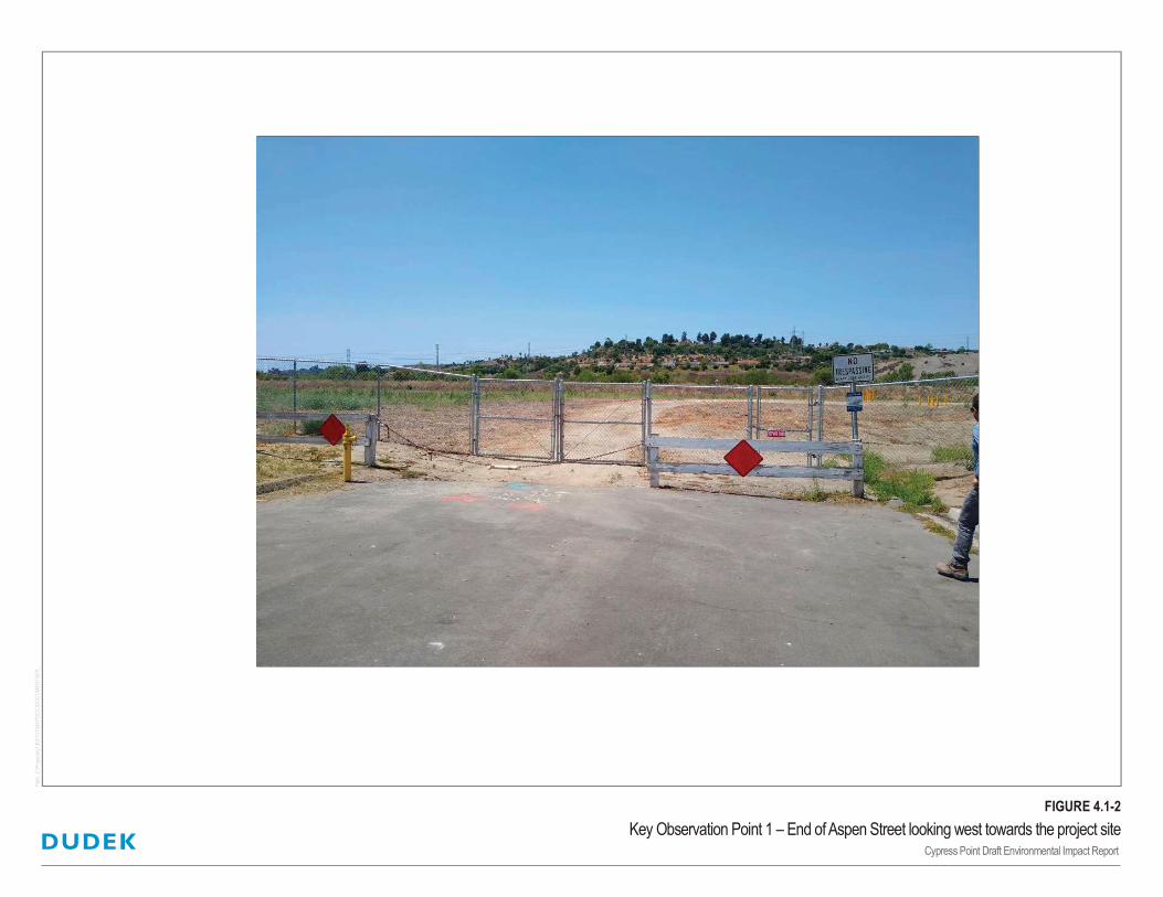
Key Observation Point 1 – End of Aspen Street looking west towards the project site
Location and Orientation
KOP 1 is located at the dead end of Aspen Street, off of Los Arbolitos Boulevard (Figure 4.1-2).
From KOP 1, the viewer looks directly across the middle of the project site to the west.
Visual Character
The foreground and middle ground of this view consists of a dirt path and low form of non-native
grasses on-site. The berm that makes up the San Luis Rey River trail bike path blocks any views
of the San Luis Rey River. The background of this KOP is made up of an ascending hill developed
with single family residences on Rivertree Drive and scattered with dark green trees atop of the
hill. An existing overhead utility line runs from the far left of the background in this KOP, up over
the hill and continues north. One cannot see beyond the hill in the background of this KOP.
4.1 – AESTHETICS
Cypress Point Project Environmental Impact Report 13021
October 2021 4.1-7
Visual Quality
The vividness of the KOP 1 landscape is moderately low, as the juxtaposition of urban and natural
elements in the visual landscape is commonplace for viewers in this neighborhood. In addition,
the elements visible in the landscape are not particularly memorable and the urban and natural
elements do not create overly distinct and striking visual patterns. With the exception of the
transmission line structures, the scale of elements within the landscape is relatively consistent and
unobtrusive. Therefore, intactness is considered to be moderate. Lastly, the visible landscape is
considered to have moderate visual unity. While the asphalt surface of the foreground contrasts
with the green-tan color of the patchy vegetation on-site in the middle ground of this KOP, the
overall visual pattern is relatively coherent. The inclusion of vegetation softens the prominence of
urban features in the background landscape, and the limited number of skylined structures
maintains the overall integrity of the expansive sky, which contributes to the overall visual quality.
Viewer Response
Sensitive viewers associated with KOP 1 is representative of residents along Los Arbolitos
Boulevard, specifically those who’s backyards face west towards the project site. Pedestrians and
motorists on Los Arbolitos Boulevard at the Aspen Street arm are also afforded this view. Because
there are only a select number of residences, pedestrians, and motorists on Los Arbolitos
Boulevard that would be subject to these direct views, the viewer volume is considered to be low.
However, due to the close proximity and vacant flat state of the project site, view exposure and
sensitivity for private residents, pedestrians and motorists from this KOP is anticipated to be high.
Key Observation Point 2 – Southwest corner of the project site looking east towards the
existing end of Pala Road
Location and Orientation
KOP 2 is located adjacent to the southwestern corner of the project site, which is the southeastern
corner of the adjacent designated open space area to the west of the project site (Figure 4.1-3). The
view from this KOP looks east across the southern boundary of the project site, towards the
existing dead end of Pala Road, and the backyard fence line of residences on Los Arbolitos
Boulevard just north of the Pala Road dead end, and those residences on Hunter Street immediately
south of the Pala Road dead end.
Visual Character
The foreground of KOP 2 consists of a dirt path cleared by pedestrian use. This dirt path runs
east towards the dead end of Pala Road, across the southern boundary of the project site. Areas
in the foreground and middle ground on either side of the dirt path consist of flat topography
4.1 – AESTHETICS
Cypress Point Project Environmental Impact Report 13021
October 2021 4.1-8
sparsely covered with green and dried low-lying grasses and weeds. In the far middle ground of
this KOP, one can see the rooftops of the single-story residences to the south and east of the
project site, past the back yard fence lines of these residences. The rooftops vary in color from
brick red, tan and gray. Additionally, one can see indirect distant views of the white fencing that
blocks off the end of Pala Road. Beyond the rooftops of residences in the middle ground, the
background of this KOP is made up of scattered tall dark green trees varying in species. No
views are afforded beyond the tree line.
Visual Quality
The visual quality from this KOP is considered low. The vegetation composing majority of the
view consists of sparse non-native grasses and is broken up by dirt paths. Visual intactness is
similarly low. From the view afforded to pedestrians at KOP 2, one can tell the entirety of the
foreground and middle ground is heavily disturbed, and the rooftops of residences in the far middle
ground creates a slight contrast in color and texture with the surrounding vegetation. Lastly,
although the view from KOP 2 is expansive and provides opportunity for wide, long views, the
view is not overly striking, and visual elements in the landscape are generally muted. Therefore,
the vividness of KOP 2 is considered low.
Viewer Response
KOP 2 viewers would exclusively consist of pedestrians accessing the open space area west of the
project site, either coming from the path that continues south, the path continuing north of the
project site, the path cut along the southern boundary of the project site from Pala Road, or the
path cut from the San Luis Rey River Trail immediately west of this KOP. Due to the location of
this KOP, there is not heavy public usage of these paths, and the viewer volume is considered low.
Viewer exposure is also considered low due to the lack of views beyond the project site, and due
to the lack of memorable views and viewer volume from this KOP, visual sensitivity is similarly
considered to be low.
Key Observation Point 3 – From the San Luis Rey River Trail looking northeast
Location and Orientation
KOP 3 is located on the San Luis Rey River Trail looking northeast across the flat topography of
the designated open space area and project site (Figure 4.1-4). From this KOP, the viewer can see
majority of the project site, with the exception of the southern-most portion of the project site.
4.1 – AESTHETICS
Cypress Point Project Environmental Impact Report 13021
October 2021 4.1-9
Visual Character
The foreground views from KOP 3 consist of the flat topography of the San Luis Rey River Trail,
which sits on a berm and gently slopes downward to the east to meet a storm drain culvert prior to
connecting to the designated open space area west of the project site. The topography of the
previously disturbed open space area and project site is generally flat, covered in low-lying non-
native grasses and weeds, as well as pedestrian dirt paths. To the far left of this KOP (to the west),
one can see length of the San Luis Rey River trail that runs directly adjacent to the project sites
western boundary, prior to wrapping around the northern portion of the project site. The San Luis
Rey River trail is paved and striped to designate the north and southbound lane. Gravel lines either
side of the bike trail, and past the graveled area to the west, thick vegetation separates the trail
from the San Luis Rey River. Due to the existing vegetation, views of the San Luis Rey River are
not available from this KOP. In the middle ground beyond the project site’s eastern boundary, one
can see the backyard fence line and rooftops of the residences along the western side of Los
Arbolitos Boulevard. As described previously, the rooftops of these single-story residences vary
in neutral colors. Other homes in this neighborhood are not visible from this KOP past the rooftops
of the homes on the west side of Los Arbolitos, only tall standing trees. In the background of this
KOP, one can see the low profile of the gently rolling, sparsely vegetated hills. The visual height
of these hills extends just above the middle ground topography before meeting the skyline.
Visual Quality
The unity of KOP 3 is moderately low. The juxtaposition of natural vegetation adjacent to San
Luis Rey River, the gravel and asphalt trail, and the heavily disturbed, flat and sparsely vegetated
open space and project site weaken the overall integrity of the visual pattern. The forms of natural
and urban visual elements tend to contrast with one another, and encroaching features (storm drain
culvert, and no trespassing signage) are visible from KOP 3. Vividness is also moderately low as
the mix of urban land uses adjacent to the natural vegetation associated with the river is
commonplace along the San Luis Rey corridor. Also, while the horizon is low and there are views
of distant undeveloped hillsides, there is a lack of distinguishing/striking visual elements in the
middleground or background viewing distance that would make this view particularly memorable.
Finally, the intactness of KOP 3 is similarly considered to be low due to the varying natural,
disturbed and developed land cover across this view.
Viewer Response
Viewers of KOP 3 would exclusively consist of bikers and recreationalists along the San Luis Rey
River bike trail, traveling north. Given the specific location and audience of KOP 3, viewer volume
is anticipated to be low, and these viewers would have low exposure (views would be brief) and
low sensitivity to the surrounding visual environment described above.
4.1 – AESTHETICS
Cypress Point Project Environmental Impact Report 13021
October 2021 4.1-10
4.1.3 Regulatory Setting
State
California Scenic Highway Program
California’s Scenic Highway Program was created by the state legislature in 1963. This program’s
purpose is to “preserve and protect scenic highway corridors from change that would diminish the
aesthetic value of lands adjacent to highways” (Caltrans 2011). The state laws governing the
Scenic Highway Program are found in the Streets and Highways Code, Section 260 et seq. The
California Scenic Highway System includes a list of highways that are officially designated as
scenic highways or eligible for designation as scenic highways.
Local
City of Oceanside General Plan
The City’s General Plan Land Use Element outlines goals and policies related to aesthetics, including
providing site design visually compatible with the surrounding open space environment when adjacent
to scenic or recreational areas. Table 4.10-1 in Chapter 4.10 of this EIR outlines the project’s consistency
with goals and policies of the City’s General Plan Elements. The Environmental Resource Management
Element (City of Oceanside 2002) provides the following table listing visual open space resources:
Table 4.1-1
Visual Open Space
Visual Resource
Pacific Ocean Cemetery
MCB Camp Pendleton Utility Easement
San Luis Rey River Buena Vista Lagoon
Mission San Luis Rey Hosp Grove
Rosicrucian Fellowship St. Charles Priory (Prince/Peace Abbey)
Source: City of Oceanside 2002.
City of Oceanside Municipal Code - Chapter 39 Light Pollution Regulations
Chapter 39 of the City of Oceanside Municipal Code restricts the permitted use of certain light fixtures
that emit undesirable light rays into the night sky (City of Oceanside 1991). This section of the
municipal code regulates the usage of lighting intended for general illumination (Class II lighting) and
the usage of decorative lighting, including building façade and landscape lighting (Class III lighting).
For general illumination of parking lots, roadways, and security, low-pressure sodium lights are
permitted as are other lights of 4050 lumens or less (similar lamp types are permitted for Class III
(decorative) lighting). For all use types, permitted lighting shall be fully shielded where feasible and
partially shielded in all other cases, and shall be focused to minimize light that would affect the night
4.1 – AESTHETICS
Cypress Point Project Environmental Impact Report 13021
October 2021 4.1-11
sky. Lastly, as stated in Section 39.8(c), all Class II lighting may remain illuminated all night and
pursuant to Section 39.8(d), all Class III lighting shall be off between 11:00 p.m. and sunrise.
4.1.4 Thresholds of Significance
The significance criteria used to evaluate the project impacts to aesthetics are based on Appendix
G of the CEQA Guidelines. According to Appendix G of the CEQA Guidelines, a significant
impact related to aesthetics would occur if the proposed project would:
1. Have a substantial adverse effect on a scenic vista.
2. Substantially damage scenic resources including, but not limited to, trees, rock
outcroppings, and historic buildings within a state scenic highway.
3. Substantially degrade the existing visual character or quality of public views of the site and
its surroundings? (Public views are those that are experienced from publicly accessible
vantage point). If the project is in an urbanized area, would the project conflict with
applicable zoning and other regulations governing scenic quality.
4. Create a new source of substantial light or glare which would adversely affect day or
nighttime views in the area.
4.1.5 Impacts Analysis
Would the project have a substantial adverse effect on a scenic vista?
Of the visual resources listed above in Table 4.1-1, the San Luis Rey River corridor is the only
visual open space scenic resource adjacent to the project site. The project site is not located within
the public viewshed of the other identified visual open space areas in the City. Due to the heavy
vegetation along the San Luis Rey River bank just west of the elevated bike trail, as well as the
intervening undeveloped project site and designated open space area, existing views of the River
corridor are not available to residents to the east or south of the project site. Please refer to Figures
4.1-2 and 4.1-4 which show existing public views both east and west of the project site towards
the river corridor. Therefore, implementation of the project would not block any existing views of
the River. Indirect and direct views of the river are mainly accessible from the river trail, and the
proposed project would not prohibit any existing designated public access to the trail. As outlined
in Table 4.10-1 in Chapter 4.10 of this EIR, project implementation would not conflict with any
of the City’s General Plan policies or goals, including designated visual open space resources listed
in the Environmental Resource Management Element. Therefore, per the City’s General Plan,
impacts to a scenic vista is determined to be less than significant.
4.1 – AESTHETICS
Cypress Point Project Environmental Impact Report 13021
October 2021 4.1-12
Would the project substantially damage scenic resources including, but not limited to, trees,
rock outcroppings, and historic buildings within a state scenic highway?
As described in Section 4.1.1 above, the project site is not located adjacent to, or in the vicinity of,
a designated state scenic highway (Caltrans 2018). The nearest officially designated state scenic
highway, State Route (SR) 52 as it travels adjacent to Mission Trails Regional Park (approximately
Santo Road in San Diego to Mast Boulevard in Santee) is located approximately 31 miles to the
south of the project site. Interstate (I) 5, approximately 3 miles to the west of the project site, and
State Highway 76, approximately 1 mile to the south of the project site, are the nearest eligible
state scenic highways to the project site (Caltrans 2018). Due to distance and intervening terrain,
the project site is not visible from I-5, State Highway 76, or any other state scenic highway in San
Diego County. Additionally, the project site is undeveloped and has been previously disturbed,
and does not include any trees, rock outcroppings, or historic buildings on-site, in proposed
improvement areas, or within the biological study area. Therefore, the project would not
substantially damage scenic resources including, but not limited to, trees, rock outcroppings, and
historic buildings within a state scenic highway, and no impacts would occur.
In non-urbanized areas, would the project substantially degrade the existing visual character or
quality of public views of the site and its surroundings? (Public views are those that are
experienced from publicly accessible vantage point). If the project is in an urbanized area, would
the project conflict with applicable zoning and other regulations governing scenic quality?
Although the project site sits on the edge of the San Luis Rey River corridor and designated open
space area, the proposed project site is considered to be located in an urbanized area of the City,
as it is adjacent to existing neighborhoods and within close proximity to existing commercial retail
areas, schools, parks, and major roadways, and would be adequately serviced by existing public
services and utilities. Therefore, as the project site is located in an urbanized area, the analysis of
degradation of existing visual character and quality of public views of the site and its surroundings
is not required per this threshold. However, for informational purposes, three public view KOPs
were reviewed to consider existing views from publicly accessible vantage points, and potential
impacts to these views as a result of project implementation, as outlined in Section 4.1.1.1 above.
As described in Section 4.1.1.1, existing views from the three KOPs were not considered to have
high visual character or quality due to the lack of memorable features and flat topography, heavily
disturbed project site and adjacent open space area, and the lack of available views of the San Luis
Rey River due to existing vegetation and topography. Implementation of the project would result
in substantial visual changes to the project site however, as it would develop a currently vacant
site into a 54-unit two-story single-family community. Expected visual changes from the three
KOPs as a result of project development is discussed below.
4.1 – AESTHETICS
Cypress Point Project Environmental Impact Report 13021
October 2021 4.1-13
Key Observation Point 1 – End of Aspen Street looking west towards the project site
As described in Section 4.1.1.1, KOP 1 is located at the dead end of Aspen Street, off of Los
Arbolitos Boulevard (Figure 4.1-2). From the existing view at KOP 1, the viewer looks directly
across the middle of the project site to the west, and is afforded views of the disturbed project site
and designated open space area, the berm that makes up the San Luis Rey River trail bike path,
and in the background an ascending hill developed with single family residences on Rivertree
Drive, west of the San Luis Rey River corridor. Heavy vegetation along the eastern San Luis Rey
River bank blocks any views of the river from this KOP. As mentioned above, this public view
point would be representative of residents, pedestrians and motorists in the adjacent neighborhood.
Upon project implementation, the viewer from this KOP would look through a proposed private
gate into the project development. Direct views of the proposed private open space and passive
recreational area located in the middle of the proposed development would be immediately
available from this KOP. The front yards of some of the eastern facing proposed residences would
also be visible from this KOP (please refer to Figure 3-3, Project Rendering, in Chapter 3 of this
EIR). Although the proposed homes on-site would be two-story, which would differ from the
existing single-family homes along the project’s eastern and southern boundary, there are scattered
two-story homes in the surrounding neighborhoods on Cypress Road, slightly further east off of
Pala Road and Rio Vista Drive, and west of the San Luis Rey River corridor on Rivertree Drive.
Implementation of the project would shield views of the open space area, the bike trail, and the
developed hillside in the background from this KOP; however, there are no afforded views beyond
these features that are considered to have high visual character and quality. Therefore,
implementation of the project is not expected to substantially degrade views from this KOP, and
development of the project would be consistent with the surrounding residential neighborhoods.
Key Observation Point 2 – Southwest corner of the project site looking east towards the
existing end of Pala Road
As described in Section 4.1.1.1, KOP 2 is located adjacent to the southwestern corner of the project
site, which is the southeastern corner of the adjacent designated open space area to the west of the
project site (Figure 4.1-3). The view from this KOP looks east across the southern boundary of the
project site, towards the existing dead end of Pala Road, and the backyard fence line of residences
on Los Arbolitos Boulevard just north of the Pala Road dead end, and those residences on Hunter
Street immediately south of the Pala Road dead end. From the existing view at KOP 2, the viewer
is afforded unobstructed views of the southern portion of the project site which consists of a dirt
path cleared by pedestrian use and non-native grasses and weeds. One can also see the rooftops of
the single-story residences to the south and east of the project site, past the back yard fence lines
of these residences. Beyond the rooftops of residences in the middle ground, the background of
this KOP is made up of scattered tall dark green trees varying in species. No views are afforded
beyond the tree line. This view is representative of pedestrians and recreationalists utilizing the
4.1 – AESTHETICS
Cypress Point Project Environmental Impact Report 13021
October 2021 4.1-14
path that runs through the existing designated open space area west of the project site. With project
implementation, views from this KOP would substantially change, as Pala Road would be
extended to this point to serve as primary access to the project site. The viewer would see the
landscaped areas and entrance along the southern boundary of the project site and would no longer
see the rooftops of the homes along Los Arbolitos Boulevard. However, the view of rooftops of
homes along Hunter Street would remain unobstructed. Past the project fence line, one would be
able to see the second story of proposed homes in the southern portion of the project site. As there
are no existing high-quality views afforded from this KOP, implementation of the project is not
expected to substantially degrade the view from this KOP, and development of the project would
be consistent with the surrounding residential neighborhoods in the area.
Key Observation Point 3 – From the San Luis Rey River Trail looking northeast
As described in Section 4.1.1.1, KOP 3 is located on the San Luis Rey River Trail looking northeast
across the flat topography of the designated open space area and project site (Figure 4.1-4). From
this KOP, the viewer can see majority of the project site, with the exception of the southern-most
portion of the project site. From the existing view at KOP 3, the viewer is afforded unobstructed
views the San Luis Rey River Trail, the designated open space area west of the project site, the
northern portion of the project site, and the skyline north beyond the San Luis Rey River corridor.
Due to the existing vegetation, views of the San Luis Rey River are not available from this KOP.
In the middle ground beyond the project site’s eastern boundary, one can see the backyard fence
line, rooftops, and tall standing landscaping of the residences along the western side of Los
Arbolitos Boulevard. In the background of this KOP, one can see the low profile of the gently
rolling, sparsely vegetated hills. The visual height of these hills extends just above the middle
ground topography before meeting the skyline. The primary audience from this KOP would be
cyclists and recreationalists utilizing the trail. With project implementation, the northwestern view
from this KOP would remain unaltered. Project development would not change the view of the
San Luis Rey River bike trail, or designated open space area. However, the proposed development
would be visible in the middle ground of this KOP looking northeast. Beyond the western fence
line of the proposed development, one would be able to see the second story of the proposed
homes, and views of the rooftops of the residents on Los Arbolitos Boulevard and beyond would
be blocked. Although the tops of gently rolling hills can be seen just beyond the Los Arbolitos
resident’s roofline, they are not considered prominent features. Additionally, as described above,
considering the audience from this KOP, views from this point would be temporary as they move
along the trail. As there are no existing high-quality views afforded from this KOP, implementation
of the project is not expected to substantially degrade the view from this KOP, and development
of the project would be consistent with the surrounding residential neighborhoods in the area.
As the project is considered to be in an urbanized area, project consistency with applicable
regulations governing scenic quality is outlined below, to address this threshold.
4.1 – AESTHETICS
Cypress Point Project Environmental Impact Report 13021
October 2021 4.1-15
General Plan
As described in response to Threshold 1 above, of the visual resources listed in the City’s General
Plan Environmental Resource Management Element (see Table 4.1-1 above), the San Luis Rey
River corridor is the only visual open space scenic resource adjacent to the project site. The project
site is not located within the public viewshed of the other identified visual open space areas in the
City. Due to the heavy vegetation along the San Luis Rey River bank just west of the elevated bike
trail, as well as the intervening undeveloped project site and designated open space area, existing
views of the River corridor are not available to residents to the east or south of the project site.
Therefore, implementation of the project would not block any existing views of the River. Indirect
and direct views of the river are mainly accessible from the river trail, and the proposed project
would not prohibit any existing designated public access to the trail. As outlined in Table 4.10-1
in Chapter 4.10 of this EIR, project implementation would not conflict with any of the City’s
General Plan policies or goals related to aesthetics or scenic quality, including designated visual
open space resources listed in the Environmental Resource Management Element.
The project would provide a high-quality architectural style inspired by traditional farmhouse styles
with patios at the face of each home making the pedestrian entry a focal point, with garages set back
in a less prominent location that accommodates a full-size driveway (Figure 3-3, Project Rendering).
Three different elevations would be provided for each of the four (4) floorplans, allowing for a
variety of facades and a diverse street scene. Proposed building material finishes would include
stucco finish, Hardie board vertical siding, decorative rafter tails, vinyl windows, and painted wood
beams and shutters. The proposed building height would be a maximum of 25 feet above grade,
which is less than the 36-foot zoning code height limit. As described in Chapter 3 of this EIR, the
project is requesting a waiver pursuant to Density Bonus law for 5-foot side and corner setbacks, 10-
foot rear setbacks, 11.5-foot setbacks from the front of the building façade to the property line
perpendicular to the front façade, 6.5-foot setbacks from the porch to the property line, and 20-foot
setbacks to the garage. The project design is intended to promote the use of outdoor space and
pedestrian usage. Additionally, the proposed homes in the development would be setback from
existing residential homes along the eastern project boundary by approximately 70 – 75 feet from
structure to structure with 48 feet separation between property lines, in order to provide privacy and
visual relief to the existing homes on Los Arbolitos Boulevard.
Proposed landscaping is designed to provide a distinct visual character and enhance the project.
The preliminary landscaping plan is shown in Figure 3-2, Landscape Plan, in Chapter 3 of this
EIR. The primary entrance at the Pala Road extension would include the addition of street trees
and ground level vegetation. Additional landscape opportunities are provided at the southern edge
of the project, with three of the four bio-basins on site being located along Pala Road. The entry at
Pala Road will be a private gate that will be owned and operated by the HOA for the benefit of the
homeowners. The secondary entrance at Aspen Street, serves as an emergency only access to the

4.1 – AESTHETICS
Cypress Point Project Environmental Impact Report 13021
October 2021 4.1-16
existing neighborhood and would be improved through the reconstruction of sidewalks on both
sides of the street with street trees between the sidewalk and the existing homes. Homeowners will
not be able to access Los Arbolitos from the project site via vehicles. At the northwest corner of
the site, existing vegetation along the San Luis Rey would be left undisturbed. A four-foot wall is
located on the northwest corner of the private road facing the trail, with a masonry wall above that
connects to the masonry perimeter wall for safety and to prohibit human encroachment into the
river buffer and the hardline preserve.
There would be a masonry perimeter wall that would prevent access from the developed site towards
the trail in order to protect the natural landscape and help minimize light intrusion into the area. Wood
fencing would provide privacy around yards, except for some lots along the northern and western
boundaries of the project site, which will have retaining walls. These retaining walls are included to
accommodate the increased elevation of the site necessary to raise the site out of the floodplain, provide
appropriate site drainage, and to accommodate existing and proposed City trunk utility pipes. These
walls are 4 to 5-feet high facing open space, the eastern neighbors and the San Luis Rey Trail, and
have open tubular steel fencing above where needed for security. All backyard and fenced side yard
spaces are private and would be maintained by the homeowner.
A variety of bushes and planting would create a buffer to the existing homes in the area where
underground utilities limit the use of trees. Landscaping would be in front of all walls where
possible, except along the western boundary where walls are located on the property line. Water
conserving landscaping and efficient irrigation design would be utilized, along with consideration
of aesthetic and functional requirements for the site. Landscaping adjacent to public rights-of-
ways, including the central green space, stormwater basins, and the front yards of residences would
be maintained by an HOA.
The proposed project has been designed to protect adjacent open space, appropriately transition
into the designated Single Family Detached Residential (SFD-R) land use for the project site, and
compliment the surrounding neighborhoods. The project would be consistent with the Single
Family Detached Residential (SFD-R) General Plan land use designation and would not require
any General Plan Amendments. Final site plans and landscape plans would be subject to review
and approval by the City. As the project would not conflict with any General Plan policies or goals
related to scenic quality, and the proposed development would be consistent with the designated
land use for the site, project implementation would be in compliance with the City’s General Plan.
City of Oceanside Zoning Ordinance
The project site is zoned RS-Single family residential, corresponding with the General Plan
designation of Single Family Detached Residential (SFD-R). Surrounding areas to the project site
are zoned open space (to the north and west of the project site), and a variety of residential zones,
including RS (Single-Family Residential District), RM-A (Medium Density A District), RM-B
4.1 – AESTHETICS
Cypress Point Project Environmental Impact Report 13021
October 2021 4.1-17
(Medium Density B District), and RH (High-Density Residential District) in the adjacent
neighborhoods (to the east and south of the project site).
Consistent with the City’s General Plan and Zoning Ordinance, the proposed project requires
certain entitlements be submitted, reviewed, and approved by the City. The requested entitlements
include a Tentative Map and a Request for Density Bonus. As the project proposes 8 low-income
units, Density Bonus Law requires the City to grant an incentive/concession and unlimited waivers.
In order to accommodate the increased density allowed under Density Bonus Law and maintain
the single-family lot design and character of the underlying zone, the project cannot physically
comply with all of the development standards that apply to standard projects. Based on the
proposed design to accommodate Density Bonus units, the project seeks a waiver of development
standards for a housing development pursuant to Density Bonus law, including, overall lot size,
lot width, setbacks, lot front landscaping requirements, and fences and walls height and plantable
retaining walls. A summary of the development standards and required waivers are outlined in
Table 3-4 in Chapter 3 of this EIR, to demonstrate compliance with the RS zone, or where Density
Bonus waivers are requested. Development standards for the RS Zone is also described in detail
in Chapter 4.10, Land Use, of this EIR.
The City would use this EIR and associated documentation in its decision to approve or deny the
required discretionary permits. With City approval of the required discretionary permits, the
project would not result in any zoning ordinance or general plan conflicts that would lead to
significant scenic quality impacts. For these reasons analyzed above, impacts are determined to be
less than significant.
Would the project create a new source of substantial light or glare which would adversely affect
day or nighttime views in the area?
Lighting for the proposed project would be provided throughout the project site, affixed to
residential facades, along the pedestrian walkways, and in open space areas. Lighting features
would consist of energy-efficient lighting that would be fully shielded and directed downward to
minimize light trespass onto surrounding properties. Exterior lighting would be turned off during
daylight hours.
The proposed project has the potential to create new light sources in the project area due to the
introduction of new housing on a currently vacant site. However, energy-efficient lighting is
proposed for interior and exterior use. All outdoor lighting would meet Chapter 39 of the City
Municipal Code (light pollution ordinance) and would be shielded appropriately. Street lighting
would be provided through lighting on individual homes rather than overhead lighting to reduce
lighting impacts to the surrounding open space areas and improve dark sky regulation compliance.
Through compliance with the municipal code, proposed outdoor lighting would not substantially
4.1 – AESTHETICS
Cypress Point Project Environmental Impact Report 13021
October 2021 4.1-18
affect day or nighttime views. Additionally, a masonry perimeter wall is proposed that would prevent
access from the developed site towards the trail in order to protect the natural landscape and help
minimize light intrusion into the area.
The project proposes the use of photovoltaic (solar) panels to increase sustainability within the
community and reduce energy requirements of, and energy-related greenhouse gas emissions of
the proposed project. Exact solar panel features and locations for the proposed project are to be
determined prior to building permit issuance. Although the proposed solar panels have the
potential for glare during sunlight hours, solar panels are generally designed to absorb light not
reflect it and typically generate glare only at acute angles. The design and location of the solar
panels would minimize the potential for glare to nearby neighbors and would not result in glare
that would be experienced from any roads.
The project is in a built-up area where night lighting is a common feature. Existing light sources
in the area include streetlights, residential exterior and interior lighting from adjacent
neighborhoods to the east and south. The project would not create any new sources of substantial
light or glare that differ from existing surrounding light sources that would affect day or nighttime
views. Additionally, compliance with the City’s Municipal Code, and implementation of project
design features, which will be required as a condition of project approval, would ensure impacts
related to light and glare would be less than significant.
4.1.6 Mitigation Measures
Impacts related to aesthetics as a result of project implementation are determined to be less than
significant, and therefore no mitigation measures are required.
4.1.7 Level of Significance After Mitigation
No substantial impacts related to aesthetics were identified; therefore, no mitigation measures are
required. Impacts related to aesthetics would be less than significant.
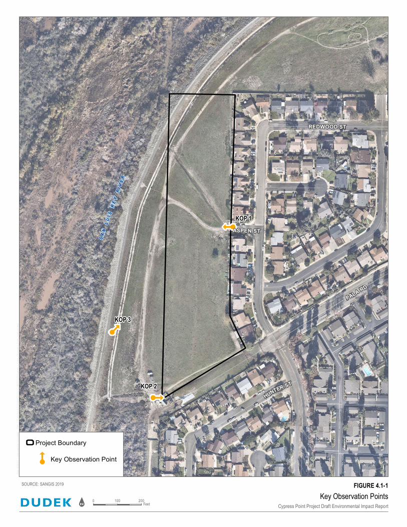
REDWOOD ST
ASPEN ST
KOP 1
KOP 2
KOP 3
Key Observation PointsCypress Point Project Draft Environmental Impact Report
SOURCE: SANGIS 2019
0 200100Feet
Project Boundary
Key Observation Point
FIGURE 4.1-1
4.1 – AESTHETICS
Cypress Point Project Environmental Impact Report 13021
October 2021 4.1-20
INTENTIONALLY LEFT BLANK

4.1 – AESTHETICS
Cypress Point Project Environmental Impact Report 13021
October 2021 4.1-22
INTENTIONALLY LEFT BLANK


4.1 – AESTHETICS
Cypress Point Project Environmental Impact Report 13021
October 2021 4.1-24
INTENTIONALLY LEFT BLANK


4.1 – AESTHETICS
Cypress Point Project Environmental Impact Report 13021
October 2021 4.1-26
INTENTIONALLY LEFT BLANK