Embed Size (px)
Citation preview

CHAPTER 1.0 INTRODUCTION
PROJECT NO. 120045 JANUARY 3, 2019 1-1
1.1 Programmatic SEPA Review
The purpose of this Programmatic Environmental Impact Statement (PEIS) is to evaluate
the potential environmental impacts of implementing a comprehensive water resource
management plan in the Icicle Creek Subbasin, with the Guiding Principles as the water
management objectives. In accordance with State Environmental Policy Act (SEPA), the
proposal includes preparation of a PEIS (this document) to identify potential
environmental impacts, mitigation strategies, and a preferred alternative.
The alternatives identified as potentially meeting the Guiding Principles are generally not
at a project-level environmental review because they are still in the planning phase. In
accordance with WAC 197-11-704, this PEIS evaluates non-project actions such as
policies, plans, and programs at a programmatic level. However, where project level
information is available, the co-lead agencies for this PEIS have attempted to include it.
Additionally, the PEIS will serve as a foundational document for future project-level
environmental review. Future environmental review is described in Section 1.9.
SEPA applies to all decisions made by state and local agencies in Washington State. Under
SEPA, one government agency is typically identified as the lead agency for identifying and
evaluating the potential adverse environmental impacts of a proposal. This evaluation is
documented and sent to the public and other agencies for their review and comment.
The EIS provides critical information to all agencies in the environmental review and approval
process. This information also helps to determine if avoidance, minimization, or compensatory
mitigation measures will address any probable significant impacts.
For the Icicle Creek Water Resource Management Strategy (Icicle Strategy), the co-
conveners (Ecology and Chelan County) entered into a Memorandum of Understanding
to act as SEPA co-lead agencies per Chapter 43.21 RCW to conduct an environmental
review of the Icicle Strategy.
See Section 1.9 for an overview of the SEPA process.
1.1.1 Document Organization
This PEIS discusses the development of the Icicle Strategy and analyzes five alternatives
for implementing the Icicle Strategy as well as a no-action alternative. This document is
organized into five main chapters, a references section, and appendices:
• Chapter 1 provides background information on the proposed Icicle Strategy,
describes the program, the purpose and need for the action, relevant background
information on the study area, history of water management in the Icicle Subbasin,
prior studies and activities dealing with water management issues, and a brief
description of public involvement.

ICICLE CREEK SUBBASIN
PROGRAMMATIC ENVIRONMENTAL IMPACT STATEMENT
1-2 PROJECT NO. 120045 JANUARY 3, 2019
• Chapter 2 presents a description of all proposed alternatives reviewed under this
PEIS. The chapter also summarizes how the alternatives were developed and
describes alternatives eliminated from detailed evaluation.
• Chapter 3 describes the affected environment and existing conditions in the Icicle
Subbasin.
• Chapter 4 evaluates the potential short-term (construction) and long-term
(operational) effects and proposed mitigation measures for all alternatives.
• Chapter 5 describes the public involvement, consultation and coordination, and
compliance with other laws that have and will occur.
• Chapter 6 will provide references used throughout the documents.
• Comments and Responses are provided in Appendix A, which includes the
comments received on the Draft PEIS as well as responses to those comments.
Appendices to accompany information presented in this PEIS are attached at the end of
the document.
1.2 Purpose and Need for Action
The purpose and need for this PEIS is the goal of the co-leads and supporting
stakeholders to develop an Icicle Creek Water Resource Management Strategy (Icicle
Strategy) through a collaborative process that will achieve diverse benefits defined by
adopted Guiding Principles for the subbasin. The current water management practices in
the Icicle Creek Subbasin fail to consistently meet the demand for instream and out-of-
stream water uses, including minimum instream flows for fish, municipal and domestic
water supply, and agricultural water supply. This has been demonstrated by the minimum
instream flows established in Chapter 173-545 WAC not being met, interruptible water
users not receiving irrigation water, and litigation over water rights and Leavenworth
National Fish Hatchery (LNFH) operations. There are additional issues in Icicle Creek
surrounding fish habitat and passage, tribal and non-tribal fish harvest, and sustainable
operation of the LNFH. The following sections summarize some of the key issues in
water resource management and watershed function within Icicle Creek that lead to a
need for comprehensive water resource management within the Subbasin.
Instream Flows: Instream flows in Icicle Creek are an important component of the local
and regional environmental value system. Benefits of adequate instream flows include
healthy aquatic and riparian ecosystems, protection of Endangered Species Act (ESA)
listed fish species, water quality, aesthetics, and recreation. Instream flow protection has
been promoted through instream flow rules and watershed planning initiatives, with high
importance assigned to improving habitat for salmonids. However, instream flows in late
summer often drop below those set in WAC 173-545-040. The rule sets minimum flows
in the lower reaches of Icicle Creek at 275 cfs, but in drought years flow can be less than
20 cfs in the historical channel near the LNFH. These low stream flows affect water

CHAPTER 1.0
INTRODUCTION
PROJECT NO. 120045 JANUARY 3, 2019 1-3
quality and limit habitat diversity for aquatic species, and have contributed to
exceedances of state and federal standards for temperature. Icicle Creek supports three
ESA-listed species: Upper Columbia spring Chinook salmon, steelhead, and bull trout.
Leavenworth National Fish Hatchery: The United States Bureau of Reclamation
(USBR) funds the operation and maintenance of LNFH as mitigation for fish losses
resulting from the construction of Grand Coulee Dam and creation of the Columbia Basin
Project. LNFH is operated by the United States Fish and Wildlife Service (USFWS) on
behalf of USBR. Water supply to the hatchery is from a combination of Icicle Creek
flows and groundwater wells with reservoir storage (Snow Lakes and Nada Lake) located
in the Alpine Lakes Wilderness Area. To ensure current production goals of 1.2 million
fish are met annually, LNFH needs a reliable supply of cool, pathogen-free water year-
round.
Operations at LNFH have resulted in lawsuits and a Biological Opinion (BiOp) under the
ESA Section 7 Consultation process. These actions are discussed in more detail later in
this Chapter.
Tribal and Non-Tribal Harvest: The Yakama Nation and the Wenatchi Band of the
Colville Confederated Tribes have federally-recognized and adjudicated harvest rights in
lower Icicle Creek.
Adult spring-run Chinook salmon return to LNFH between mid-April and mid-July each
year. A tribal fishery is permitted during this time if run size is large enough to both meet
the hatchery broodstock goal of ~1,200 spawners and provide fish in excess of hatchery
needs. The broodstock goal is a function of the hatchery’s obligation under U.S. v.
Oregon to produce 1.2 million juvenile spring Chinook salmon (Parker, 2014).
The success of the tribal fishery is dependent on the concentration of returning adult
salmon in the pool at the base of the fish ladder, the location where the majority of tribal
fishing currently occurs (Parker, 2014). Tribal members fish with traditional dipnets or
with modern rod-and-reel from scaffolds/platforms erected along the streambank. As
demonstrated in Table 1-3, tribal fish harvest has declined considerably since 2001.
Domestic Supply: Icicle Creek and groundwater in the Icicle Creek Subbasin are
important water sources for municipal and domestic uses. The City of Leavenworth has a
population of ~2,000 (Census, 2010) and is an internationally renowned tourist
destination, attracting millions of visitors each year. The City of Leavenworth has
asserted water rights to withdraw up to 6.198 cfs from Icicle Creek (3.18 cfs interruptible,
3.02 cfs uninterruptible) and up to 6.68 cfs from groundwater (4.46 cfs interruptible, 2.23
cfs uninterruptible) for municipal use (Varela & Associates, 2018). Chelan County
currently supplies exempt wells under the reserve created in WAC 173-545-090.
However, these collective urban and rural water rights are not sufficient to support
population projections out to 2050. The City of Leavenworth and Ecology have litigation
on hold while they find a non-litigious solution to water management in Icicle Creek.
Agricultural Reliability: Agriculture is an important component of the Chelan County
economy. In 2012, over 75,000 acres were in agricultural production, generating
$206,000,000 in market value in Chelan County (USDA, 2012). The waters of the Icicle

ICICLE CREEK SUBBASIN
PROGRAMMATIC ENVIRONMENTAL IMPACT STATEMENT
1-4 PROJECT NO. 120045 JANUARY 3, 2019
Creek Subbasin play an important role in this agricultural production by providing water
to IPID and COIC, which supply water to nearly 9,000 acres. These 9,000 acres are
predominantly planted in tree fruit. In total, 137 cfs of irrigation diversions are authorized
from Icicle Creek.
IPID manages five lakes in the watershed to augment natural water supplies from Icicle
Creek during drought and non-drought years. In a drought year, the storage from all the
lakes are used to provide water to IPID. In non-drought years, the district drains one lake
rotationally for maintenance activities and for additional irrigation supply. Since not all
droughts are the same, in some dry years a combination of lakes (1 to 5) are drawn down.
Despite the importance of agriculture and irrigation, there is not enough water to supply
all of the irrigation demand. For example, in many drought years, IPID partially curtails
its use even with reservoir releases. Additionally, in the Icicle Creek Subbasin and
Wenatchee Basin, there are water rights that are regularly curtailed based on low
streamflow in the Wenatchee River. On average, these water users face curtailment at
least 7 out of every 10 years.
Habitat: The Upper Columbia Revised Biological Strategy (Biological Strategy, 2017)
identifies the following factors affecting habitat conditions for ESA-listed salmonids in
Icicle Creek:
• Land development downstream of LNFH has affected stream channel migration,
recruitment of large wood, and off-channel habitat.
• There is a barrier to migration in the boulder field.
• Water withdrawals in Icicle Creek (primarily between Rat Creek and the hatchery)
likely contribute to low flows and high temperatures.
• The Icicle Road upstream of Chatter Creek may confine the stream channel and
affect floodplain function in certain places.
Additional passage barriers exist at the hatchery that are used for operation, including
water management, broodstock collection, and to maintain the tribal fishery. These are
discussed in more detail in Section 1.2.1.2.
These problems have created a need to improve ecological function in Icicle Creek and to
provide reliable water resources for agriculture and domestic water users. With the
additional pressures on water resources that will likely result from a changing climate, it
is imperative to address these problems in a way that considers potential future impacts of
climate change. The Icicle Strategy seeks to address these issues while considering the
potential climate impacts and ensuring all actions comply with state and federal law,
including the Wilderness Acts.

CHAPTER 1.0
INTRODUCTION
PROJECT NO. 120045 JANUARY 3, 2019 1-5
1.3 Icicle Creek Subbasin Background and History
Icicle Creek is a major tributary of the Wenatchee River and is a significant water
resource subbasin of Water Resource Inventory Area (WRIA) 45 (Wenatchee River
Basin). Basin-wide planning is founded on the Instream Flow Rule (1983), adopted
Watershed Plan (2006), and the Detailed Implementation Plan (2008).
1.3.1 Location and Setting
Icicle Creek is the largest subbasin in WRIA 45, covering 136,916 acres. Icicle Creek
joins the Wenatchee River at RM 25.6, contributing 20 percent of the Wenatchee River’s
annual flow. Precipitation ranges from 120 inches at the Cascade crest to 20 inches at the
mouth of the Icicle. Elevation ranges from approximately 9,000 feet at the Cascade crest
to 1,102 feet at the mouth.
The U.S. Forest Service (USFS) manages 87 percent of the land in the Subbasin, of
which 74 percent of the subbasin is located within the Alpine Lakes Wilderness Area
(ALWA). The remaining 13 percent of land in the subbasin is in other federal
government, state, local, or private ownership.
Other than forestry and wilderness protection, land use within the Subbasin includes
residential and agriculture uses, which occur in the lower portion of the watershed. The
major water diversions are in the lower 5 miles of Icicle Creek for in-basin and out-of-
basin irrigation, domestic water use, and fish propagation.
1.3.2 Project Area
The Icicle Strategy focuses on the entire Icicle Creek Subbasin (see Figure 1-1). In this
document, the Icicle Creek Subbasin is defined as the Icicle Project Area. However, there
are three primary areas within and outside of the Icicle Project Area that could likely be
affected by the proposal. These areas include the Alpine Lakes area, Icicle Creek, and the
Wenatchee River Corridor downstream of the confluence with Icicle Creek. These areas
are described in greater detail below.
1.3.2.1 Alpine Lakes Area The Alpine Lakes Area encompasses the headwaters of Icicle Creek. These include several
lakes located within the ALWA, that are actively managed as reservoirs to supply IPID and
LNFH. These lakes include Upper and Lower Snow Lakes and Nada Lake, which make up
the Snow Lakes system, and Colchuck Lake, Eightmile Lake, Klonaqua Lake, and Square
Lake. These Lakes are highlighted on Figure 1-1.
Also, included in the Alpine Lakes Area are the tributaries of Icicle Creek. Of primary
interest are those that drain the above listed lakes. These tributaries include French,
Leland, Eightmile, and Snow Creeks.

ICICLE CREEK WATERSHED
PROGRAMMATIC ENVIRONMENTAL IMPACT STATEMENT
1-6 PROJECT NO. 120045 JANUARY 3, 2019
Figure 1-1. Overview Map of Icicle Subbasin

CHAPTER 1.0
INTRODUCTION
PROJECT NO. 120045 JANUARY 3, 2019 1-7
1.3.2.2 Icicle Creek This 31.8-mile area includes Upper and Lower Icicle Creek, from Josephine Lake to the
confluence with the Wenatchee River. This area includes most of the water resource
diversions, fish passage barriers, and degraded habitat that the Icicle Strategy seeks to
improve. This is also the area where critical low flows occur in the late summer and early
fall. The location of Icicle Creek can be seen on Figure 1-1.
1.3.2.3 Wenatchee River Corridor The Wenatchee River corridor describes the area downstream of Icicle Creek with its
confluence with the Wenatchee River that could be impacted by water management
changes in the Icicle Creek Subbasin. This area starts at the location where Icicle Creek is
intercepted by the Wenatchee River, slightly upstream where the City of Leavenworth
has wells in continuity with the River, and extends downstream to the confluence of the
Wenatchee River and the Columbia River near the town of Wenatchee.
1.3.3 History of Water Management
Water supply in the Icicle Creek Subbasin is heavily dependent on snow pack in the upper
reaches of the watershed. Combined with storage water from reservoirs in the upper
watershed, snowmelt is crucial for summer flows and providing water for out-of-stream
uses. The storage in the upper watershed occurs in seven reservoirs located within the
ALWA. Four of these reservoirs, Colchuck, Eightmile, Klonaqua, and Square, were built
in the 1920s to 1940s by IPID. The water stored in these reservoirs is conveyed in Icicle
Creek and its tributaries and diverted for irrigation at RM 5.7. The dams on Upper and
Lower Snow Lakes and Nada Lake were originally constructed by Icicle Irrigation District
(IID) in the 1930s and later expanded in the 1940s by USBR. The water stored in the
Snow Lake system is conveyed in Icicle Creek and its tributaries and diverted for
irrigation and fish propagation at RM 5.7 and 5.5, respectively.
Diversions from Icicle Creek were established in the early 1900s. By 1927, a water rights
adjudication was underway in the Icicle Subbasin. Generally, adjudications arise when
streamflow is insufficient to satisfy all out-of-stream demand every year. Today, there are
four large diversions on lower Icicle Creek: IPID (RM 5.7), City of Leavenworth (RM
5.7), LNFH (RM 4.5), and COIC (RM 4.5). The location of these diversions is shown on
Figure 1-1. Three of these diverters, IPID, COIC, and the City of Leavenworth, hold
adjudicated certificates that were confirmed during the 1927 adjudication.
Adequate streamflow has long been a problem in Icicle Creek. In 1983, Ecology
implemented the Wenatchee Instream Flow Rule (Chapter 173-545 WAC), which protects
flows in Icicle Creek and other rivers and streams in the Wenatchee Basin. The
recommended flows in this rule were revised in 2007 based on watershed planning. The
revised rule prescribes flows between 267 and 650 cfs of water in Icicle Creek, depending
on the time of year (Figure 1-2). The instream flow rule is discussed in more detail in
Section 3.6 of this PEIS. Currently, these instream flows are not always met. Figure 1-3
shows the Wenatchee instream flow rule compared to different flow scenarios from 1981
to 2011 on the mainstem Wenatchee. Flows in Icicle Creek near the historic channel are
much lower than in the Wenatchee River, on the order of 60 cfs in average years and less
than 20 cfs in drought years.

ICICLE CREEK SUBBASIN
PROGRAMMATIC ENVIRONMENTAL IMPACT STATEMENT
1-8 PROJECT NO. 120045 JANUARY 3, 2019
Figure 1-2. Chapter 173-545 WAC Prescribed Flows (1983 rule compared to 2007
revised rule).
Figure 1-3. Instream Flow Rule Compared to Streamflow

CHAPTER 1.0
INTRODUCTION
PROJECT NO. 120045 JANUARY 3, 2019 1-9
The Icicle Creek Subbasin and the areas downstream that are affected by its water
management have been identified as a critical area within the watershed planning process
(through the Wenatchee Instream Flow Study, Total Maximum Daily Load (TMDL)
Study, and Watershed Assessment) for meeting all of the needs it serves. Improved flow
understanding and projects envisioned by the IWG will significantly improve this current
instream flow imbalance.
1.4 The Icicle Work Group
To find solutions for water management within the Icicle Subbasin, the Chelan County
Natural Resource Department (Chelan County, County) and the Washington State
Department of Ecology’s (Ecology) Office of the Columbia River (OCR) co-convened
the Icicle Work Group (IWG, Work Group) in December 2012. The IWG comprises a
diverse set of stakeholders representing local, state, and federal agencies, tribes, irrigation
and agricultural interests, municipal/domestic water managers, and environmental
organizations (Table 1-1).
Table 1-1
List of Icicle Work Group Members
Organization Interest
Confederated Tribes & Bands of the Yakama Nation Tribal Fisheries
Confederated Tribes of the Colville Reservation Tribal Fisheries
U.S. Bureau of Reclamation (USBR) Hatchery
U.S. Fish and Wildlife Service – LNFH Hatchery
NOAA – Fisheries Fisheries
Washington State Department of Fish and Wildlife Fisheries & Wildlife
Washington State Department of Ecology Co-convener/Water Manager/ Water Supply Developer
Icicle and Peshastin Irrigation District Irrigation Water
City of Leavenworth Domestic Water
Chelan County Co-convener/Domestic Water/ Watershed Plan Implementer
Cascade Orchards Irrigation Company Irrigation Water
Icicle Creek Watershed Council Environmental
Washington Water Trust Fisheries/Environmental
Trout Unlimited – Washington Water Project Fisheries/Environmental
U.S. Forest Service Land Manager
City of Cashmere Domestic Water
Cascadia Conservation District Conservation
Agricultural Representatives (two) Irrigation Water

ICICLE CREEK SUBBASIN
PROGRAMMATIC ENVIRONMENTAL IMPACT STATEMENT
1-10 PROJECT NO. 120045 JANUARY 3, 2019
The IWG seeks to find collaborative solutions for water management within the Icicle
Creek Subbasin. This includes balancing out-of-stream water uses, such as domestic and
agricultural uses, with instream uses, such as fish habitat, recreation, and ecosystem
processes while protecting treaty and non-treaty fishing interests. The IWG’s purpose is
to develop a comprehensive Icicle Creek Water Resource Management Strategy (Icicle
Strategy) that uses best available science to identify and support water management
solutions that lead to implementation of high-priority water resource projects within the
Icicle Creek Subbasin. The IWG adopted operating procedures that include membership
selection, expectations for members, dispute resolution, conflict of interest criteria,
subcommittee procedures, and decision-making procedures.1
The IWG meets quarterly to make decisions on implementing and monitoring progress
made on the Icicle Strategy. As needed, the IWG forms subgroups that meet and inform
the IWG of the best available science to meet Icicle Strategy objectives. One key
subgroup is the IWG Instream Flow Subcommittee, which comprises local, state, federal,
and tribal fish biologists that help evaluate how additional Icicle Creek instream flow
quantities and habitat improvements made available from project implementation can be
maximized for fish benefit in Icicle Creek and its tributaries. A Steering Committee
chaired by the Washington State Department of Fish and Wildlife (WDFW) and
consisting of eight voting members of the IWG also meets regularly to help implement
IWG decisions, coordinate funding efforts, and prioritize emerging issues for IWG
consideration.
After 3 years of study, stakeholder coordination, project investigations, and collaboration
the IWG determined that the PEIS was the next appropriate step in implementing the
Icicle Strategy. This would allow greater input by the public on the Guiding Principles
and the potential projects that could collectively meet them, and help understand benefits
and impacts associated with implementation of the strategy.
1.4.1 Icicle Work Group Authority
The authority for the IWG comes from the Washington State Legislature in the form of
the Watershed Planning Act (Chapter 90.82 RCW) and the Columbia River Basin Water
Management Act (Chapter 90.90 RCW). The IWG generally consists of parties who have
come together in a collaborative and volunteer manner to help improve Icicle Creek’s
ability to meet multiple, and at times conflicting, water needs.
1.4.1.1 Watershed Planning In 1998, the Washington Legislature passed the Watershed Planning Act (Chapter 90.82
RCW). The purpose of the Watershed Management Act is to conduct watershed scale
planning for managing water resources by local entities and stakeholders. The objectives
of watershed planning are to “meet the needs of a growing population and a healthy
economy statewide, meet the needs of fish and healthy watersheds statewide, and
advance these two principles in increments over time.”
1 http://www.co.chelan.wa.us/files/natural-
resources/documents/Planning/icicle_work_group/FINAL%20IWG%20Operating%20Procedures%202016.pdf

CHAPTER 1.0
INTRODUCTION
PROJECT NO. 120045 JANUARY 3, 2019 1-11
1.4.1.2 OCR’s Authority In 2006, the Legislature tasked and funded Ecology to develop new water supplies for
both instream and out-of-stream uses. Ecology created OCR whose purpose is to develop
new water supplies using a variety of tools/project types, including; storage,
conservation, and voluntary regional water management agreements.2
The Legislature provided OCR with five directives (Chapter 90.90 RCW):
• Develop water supplies for instream as well as out-of-stream uses (RCW
90.90.020(1)(a)(ii)).
• Secure alternatives to groundwater for agricultural users in the Odessa subarea
aquifer (RCW 90.90.020(3)(a)).
• Find sources of water supply for pending water right applications (RCW
90.90.020(3)(b)).
• Find a new uninterruptible supply of water for the holders of interruptible water
rights on the Columbia River mainstem (RCW 90.90.020(3)(c)).
• Develop water sources for new municipal, domestic, industrial, and irrigation water
needs within the Columbia River Basin (RCW 90.90.020(3)(d)).
1.5 The Icicle Strategy and Guiding Principles
The Icicle Strategy is a comprehensive water resource management plan that
contemplates climate change and is designed to balance and meet out-of-stream and
instream water demand both now and into the future. The water management and
watershed conditions that led to the Icicle Strategy are discussed in Sections 1.3 and 1.4.
The IWG developed the Icicle Strategy using stakeholder input and best available
science. The centerpiece of the Icicle Strategy is the Guiding Principles, which are a set
of objectives that all members of the IWG agreed were in their mutual best interest to
collaborate on and achieve. Over a 2-day work session facilitated by USBR in December
2012, the IWG developed a list of shared goals to guide them in developing a strategy to
meet the needs of the various stakeholders in the Subbasin. This list became known as the
Guiding Principles, which have evolved since their initial development. The following is
a list of the Guiding Principles, as developed during the December 2012 work session:
1. Streamflow that:
a. Provides passage,
b. Provides healthy habitat,
c. Serves channel formation function,
d. Meets aesthetic and water quality objectives, and
e. Is resilient to climate change.
2 http://www.ecy.wa.gov/programs/wr/cwp/cr_overview.html

ICICLE CREEK SUBBASIN
PROGRAMMATIC ENVIRONMENTAL IMPACT STATEMENT
1-12 PROJECT NO. 120045 JANUARY 3, 2019
2. Sustainable LNFH that:
a. Provides healthy fish in adequate numbers,
b. Is resource efficient,
c. Significantly reduces phosphorus loading,
d. Has appropriately screened diversion(s), and
e. Does not impede fish passage.
3. Tribal treaty and federally protected fishing/harvest rights are met at all times.
4. Provide additional water to meet municipal and domestic demand.
5. Improved agricultural reliability that:
a. Is operational,
b. Is flexible,
c. Decreases risk of drought impacts, and
d. Is economically sustainable.
6. Improve ecosystem health, including protection and enhancement of aquatic and
terrestrial habitat.
7. Comply with state and federal law.
8. Protect non-treaty harvest.
9. Comply with the Wilderness Act of 1964, the Alpine Lakes Wilderness Act of
1976, and the Alpine Lakes Wilderness Management Plan.
Over the following 3-years, these Guiding Principles evolved to seven principles that
have both qualitative and quantitative descriptions. The following section, Section
1.2.1, describes the process of fine-tuning these Guiding Principles through scientific
study and consensus-based stakeholder negotiations. Section 1.2.2 describes the
Guiding Principles as they are today.
1.5.1 Refining Guiding Principles and Developing Metrics
The IWG agreed that before a set of projects could be identified to accomplish the
objectives established in the Guiding Principles, quantitative metrics and more qualitative
descriptions would be required to help define the magnitude of the gap between current
river operations and the values expressed in the Guiding Principles. Through 3-years of
scientific study and project feasibility development along with Work Group discussion,
the IWG developed metrics for their objectives. Additionally, the IWG honed their list of
nine principles into a list of seven: improve instream flows, improve sustainability of
LNFH, protect tribal and non-tribal harvest, improve domestic supply, improve
agricultural reliability, enhance Icicle Creek habitat, comply with state and federal law,
and Wilderness Acts. The following sections describe the process for developing these
metrics for each Guiding Principle.

CHAPTER 1.0
INTRODUCTION
PROJECT NO. 120045 JANUARY 3, 2019 1-13
1.5.1.1 Improve Instream Flow To determine streamflow restoration goals, the IWG formed a technical subcommittee of
experts on instream flow and fish habitat to provide technical guidance on establishing
instream flow goals for the Guiding Principles. This group is known as the Icicle Creek
Instream Flow Subcommittee (ICIFS). Much of the methodology used by the ICIFS to
make its recommendation is summarized in its presentation to the IWG in 20143. To
make flow recommendations, the ICIFS reviewed existing reports that discussed flow and
habitat in Icicle Creek and reviewed their collective understanding of how to improve
flows in Icicle Creek:
• Instream Flow Study Report for Icicle Creek (Cates, 1985)
• Icicle Creek Target Flow Report for Leavenworth National Fish Hatchery (2004)
• U.S. Bureau of Reclamation, Technical Memorandum, Instream Flow Assessment
of Icicle Creek, Washington, Ron Sutton and Chelsie Morris (2005)
• U.S. Fish and Wildlife Service, Icicle Creek Fish Passage Evaluation for the LNFH
(2013)
• U.S. Fish and Wildlife Service, Icicle Creek Instream Flow and Fish Habitat
Analysis for the LNFH (2013)
• U.S. Bureau of Reclamation, LNFH Icicle Creek Rapid Geomorphic Assessment
(2014)
The effort was complicated because different portions of Icicle Creek and its tributaries
are used by different fish species and have different limitations (e.g., flow, passage, and
habitat). To address these differences, the ICIFC researched the flow and habitat
information as well as fish utilization in different portions of the river. Based on this
research, the IWG identified the following target reaches:
Reach 1 – RM 5.7 to headwaters (upstream of major diversions)
Reach 2 – RM 5.7 to 4.5 (IPID/City of Leavenworth point of diversion to
LNFH/COIC point of diversion)
Reach 3 – RM 4.5 to 3.9 (LNFH/COIC point of diversion to Structure 2)
Reach 4 – RM 3.9 to 2.7 (the historical channel)
Reach 5 – RM 2.7 to 0.0 (downstream of LNFH outflow to the Wenatchee River
confluence)
The ICIFC then documented fish presence and life history in each of the reaches. Table
1-2 and Figure 1-4 illustrate the presence and life history of each species in Icicle Creek.
3 http://www.co.chelan.wa.us/natural-resources/pages/icicle-creek-instream-flow-committee

ICICLE CREEK SUBBASIN
PROGRAMMATIC ENVIRONMENTAL IMPACT STATEMENT
1-14 PROJECT NO. 120045 JANUARY 3, 2019
Table 1-2 Focal Fish Species by Reach
Reach River Mile Life History & Stage by Species
1 Headwaters to RM 5.7 Steelhead – P, S, R Rainbow trout – S, R Bull trout – P, S, R Cutthroat trout – R
2 RM 5.7 to RM 4.5 Steelhead – P, R Bull trout – P
3 RM 4.5 to RM 3.9 Steelhead – P, R Bull trout – P
4 RM 3.9 to RM 2.7 Steelhead – P, R, S Bull trout – P Lamprey – P
5 RM 2.7 to RM 0.0 Steelhead – S, R Bull trout – P Lamprey – P
Note – P = Passage, S = Spawning, R = Rearing Assumptions: 1) No spring Chinook salmon assessment; 2) Assumed steelhead production is present
Figure 1-4. Focal Fish Species and Relevant Life Stages Periodicity within Icicle Work
Group Study Reaches
(Source: USFWS 2013 draft) Note: Gray shading indicates utilization for each month.
For each reach, the ICIFS summarized available habitat flow relationships for likely
target species by reach as weighted usable area (WUA) by reach (Figures 1-5a through 1-
5e). WUA is the stream surface area weighted by habitat suitability variables, such as
velocity, depth, and substrate.
Life stage Mig
rati
on
Spaw
nin
g
Jan
Feb
Ma
r
Ap
r
Ma
y
Jun
e
Jul
Au
g
Sep
Oct
No
v
De
c
✓
✓
Rearing
Adult/Subadult ✓
Rearing
✓
✓
Rearing
✓
✓
Steelhead,
Rainbow trout
Bull trout
Lamprey Adult
Adult
AdultCutthroat trout

CHAPTER 1.0
INTRODUCTION
PROJECT NO. 120045 JANUARY 3, 2019 1-15
Figure 1-5a. Available Habitat by Flow for Focal Fish Species
Notes: CFS = cubic feet per second; RB = Rainbow Trout; SH = Steelhead

ICICLE CREEK SUBBASIN
PROGRAMMATIC ENVIRONMENTAL IMPACT STATEMENT
1-16 PROJECT NO. 120045 JANUARY 3, 2019
Figure 1-5b. Available Habitat by Flow for Focal Fish Species, Reach 1 and 2
Source: US Army Corp of Engineers, 1985 Notes: LF = linear feet; BT = Bull Trout
Figure 1-5c. Available Habitat by Flow for Focal Fish Species, Reach 3
Source: Montgomery, 2004

CHAPTER 1.0
INTRODUCTION
PROJECT NO. 120045 JANUARY 3, 2019 1-17
Figure 1-5d. Available Habitat by Flow for Focal Fish Species, Reach 4
Source: USFWS, 2013
Figure 1-5e. Available Habitat by Flow for Focal Fish Species, Reach 5
Source: USBOR, 2005

ICICLE CREEK SUBBASIN
PROGRAMMATIC ENVIRONMENTAL IMPACT STATEMENT
1-18 PROJECT NO. 120045 JANUARY 3, 2019
After considering all of this information, the ICIFS decided to select a key reach of the
river, fish species, and fish life stage on which to base flow recommendations. This
approach presumed that if projects were constructed that met that reach/fish/life stage
pairing, then the health of the rest of the Icicle Creek fishery would also be proportionately
improved. Flows necessary to improve steelhead rearing in the historical channel (Reach 4)
became the reference to evaluate flow improvement targets.
Maximum habitat benefit (100 percent WUA) for steelhead rearing in Reach 4 would be
achieved with a flow of 250 cubic feet per second (cfs) and the IWG adopted this as their
long-term goal. However, the IWG recognized a diminishing return on investment above
100 cfs when considering additional habitat achieved for each 1 cfs of flow improvement.
The IWG also recognized that funding may be a constraint, at least initially, to achieve
the highest level of flow improvement. Therefore, the IWG endorsed an initial flow
restoration target of 100 cfs, which increases WUA by nearly four-fold compared to the
current low flow scenarios, while maintaining the long-term restoration goal of 250 cfs.
The IWG envisions the short-term goal to be achievable within approximately 10 years,
and the long-term goal to be achievable in approximately 50 years.
1.5.1.2 Improve Sustainability of LNFH The IWG recognizes that improving sustainability of LNFH is important to the
watershed. This includes ensuring the hatchery provides healthy fish in adequate
numbers, is resource efficient, achieves improved water quality, and does not impede fish
passage. In determining metrics for this Guiding Principle, the IWG deferred to fish
production goals established in U.S. v. Oregon, which is an ongoing federal lawsuit
regarding fishing rights, and consulted with Work Group members who have expertise in
hatchery operations, ichthyology, and watershed processes. Additionally, concurrent with
the adoption process of a Guiding Principle for a sustainable hatchery by the IWG,
NOAA Fisheries was developing a new biological opinion for the hatchery, which is
discussed in more detail in Section 1.5.2.
Based on the instream flow and habitat restoration goals, and the potential for
conservation and source upgrades at the hatchery that would assist in maximizing fish
health, the IWG set several metrics for this Guiding Principle. These metrics include a
water conservation goal of 20 cfs to be left in the historical channel, operating/modifying
the passage barriers at Structure 2 and LNFH diversion (called Structure 1) to minimize
passage impediments, and ensuring cool, pathogen-free water for hatchery operations.
The location of Structure 2 and LNFH diversion are provided on Figure 1-1.
1.5.1.3 Protect Treaty/Non-treaty Harvest The fishery of the Lower Icicle Creek is a traditional fishing site for the Yakama and
Colville Tribes (Wenatchi band) traditionally known as the Wenatshapam fishery. Both
tribes exercise federally recognized fishing rights at this location, targeting adult Chinook
salmon returning to the LNFH, generally from May to late July. The Wenatshapam fishery
serves as important cultural and subsistence resources, and is one of the few locations in
the Upper Columbia River where tribal spring Chinook harvest occurs. The rights of the
Yakama and Wenatchi band to the Wenatshapam fishery has been upheld and affirmed in
US v. Oregon. All changes to water management in Icicle Creek must maintain this
fishery.

CHAPTER 1.0
INTRODUCTION
PROJECT NO. 120045 JANUARY 3, 2019 1-19
In addition to the tribal fishery on Icicle Creek, the area is popular for recreational fishing.
Consequently, the IWG has set protecting the non-treaty fishery as a Guiding Principle of the
Work Group. Trout fishing occurs in the stream from near the IPID footbridge to Leland
Creek, and throughout the Leland Creek catchment. The trout fishery is open from late May
through the end of October and the primary trout species caught is rainbow trout. There is also
a non-tribal, hatchery spring Chinook season that occurs on Icicle Creek from mid-May
through July when the number of returning salmon are sufficient to meet broodstock collection
goals at the LNFH. The average number of anglers participating in the spring Chinook fishery
is approximately 2,688 (WDFW Creel Survey, 2016). WDFW does not conduct surveys of the
trout fishery, so the average number of participating anglers is unknown.
Generally, the flow and habitat improvements endorsed by the IWG in other Guiding
Principles were thought to have a neutral to positive effect on the tribal and non-tribal fishery.
However, over the past several years, there have been documented declines in catch per unit
effort (CPUE) in the tribal harvest. Per data provided by the Yakama Nation, tribal harvest
peaked in 2001, and has been declining since. Catch numbers from 2014 indicate a 90 percent
decline from the 2001 peak harvest (Table 1-3). As such, any further modifications to Icicle
Creek could have unintended consequences and would need to be monitored closely.
Therefore, the IWG sponsored some initial evaluations (e.g., a bathymetry survey of the
current fishing area and sediment transport study) and included an adaptive management
program as part of the Guiding Principles to ensure that this important fishery is not adversely
affected.
Table 1-3
Icicle Creek Spring Chinook Fishery
Return
Year
Trapped @
Hatchery
Sport
Harvest
YN
Harvest
CCT
Harvest
Percent
Tribal
Harvest
Remaining in
River
Total
Run
1999 2,103 108 175 7.2 45 2,431
2000 4,457 1,606 3,238 34.2 163 9,464
2001 6,259 2,260 5,075 33.6 1,488 15,082
2002 6,459 1,201 3,796 30.9 828 12,284
2003 4,825 935 1,852 22.7 549 8,161
2004 2,308 347 863 23.1 214 3,732
2005 2,560 103 1,063 28.0 67 3,793
2006 1,957 529 588 18.7 73 3,147
2007 1,708 115 751 28.6 48 2,622
2008 3,229 347 1,036 21.2 283 4,895
2009 3,232 640 617 210 13.2 195 4,684
2010 11,307 993 683 310 5.2 237 13,220
2011 4,970 873 233 365 3.8 77 6,153
2012 3,749 971 287 123 5.6 131 5,138
2013 2,094 323 42 1.6 134 2,593
2014 4,375 TBD 547 10.4 357 5,279
Note – all fish are of hatchery origin
YN = Yakama Nation; CCT = Colville Confederated Tribes
Blank boxes represent absence of data

ICICLE CREEK SUBBASIN
PROGRAMMATIC ENVIRONMENTAL IMPACT STATEMENT
1-20 PROJECT NO. 120045 JANUARY 3, 2019
1.5.1.4 Improve Domestic Supply For long-term economic and water security for both urban and rural residents, and to
settle existing litigation between the City of Leavenworth and Ecology, the IWG made
meeting current and future domestic water supplies through at least 2050 a priority.
To determine domestic need through 2050, the IWG relied on the Wenatchee Watershed
Plan (2006) to predict rural development in the Icicle Creek Subbasin. The Wenatchee
Watershed Plan projected 31 new homes in the Icicle Creek Subbasin through 2014. The
Wenatchee Watershed Plan predicted demand in the Icicle subbasin for additional rural
development at 4.7 homes per year. From 2014 to 2050 (36 years), approximately 169
additional homes are anticipated for this time period. The total projected rural residential
demand through 2050 is 200 homes. Based on average indoor use of 200 gallons per day,
as estimated in the Wenatchee Watershed Plan, and an estimated consumptive outdoor
water use during the critical low flow month of September of 0.15 acre-feet (Aspect,
2013), the per unit rural domestic demand is 0.37 acre-feet per unit. The total rural
domestic demand through 2050 is estimated at 74 acre-feet.
The water need for the City of Leavenworth was determined in two phases. The first
phase was the determination of current need, as demonstrated in litigation over water
rights with the Department of Ecology. This litigation is over the rights to 800 acre-feet
of water. The second phase was to determine the future demand through 2050 using the
City of Leavenworth Water System Plan (2011). This plan predicts the additional future
water need at 867 acre-feet. Based on the average per unit use of 304 gallons per day, or
0.34 acre-feet per year (Water System Plan, 2001), this would provide water to 2,546 new
residential and commercial connections (Table 1-4). The total water needed to meet
future demand thru 2050 in the City of Leavenworth is 1,667 acre-feet.
Table 1-4
Projected Municipal & Domestic Water Demand through 2050
acre-feet/unit1
Projected & Current Need
(acre-feet)
Total Additional Units
City of Leavenworth 0.34 1,667 2,546
Exempt Wells, Icicle Basin2 0.37 74 199
1City of Leavenworth gpd/unit is the City of Leavenworth Water System Plan (2011) 2Exempt Wells use is Wenatchee Reserve Account Review (Aspect Consulting, 2013)
1.5.1.5 Improve Agricultural Reliability Improving agricultural reliability is focused on giving interruptible water users a firm
water supply. An interruptible water user is a water user whose water right has a later
priority date than the instream flow rule, making the water right junior to the instream
flow rule. An instream flow rule, which is discussed in more detail in Section 1.4.2, is a
water right to protect environmental flows in a river or stream. If a water right is junior to
the instream flow rule, it can only be used when the instream flow rule is met. In
Washington water law, a water user can only exercise their water right when senior water
rights in the basin are fully satisfied. To determine the extent of the interruptible water
user issue, we reviewed all water right holders with an interruptible provision within the
Wenatchee Basin and found 47 interruptible water users. Of these 47 interruptible rights,
CHAPTER 1.0
INTRODUCTION
PROJECT NO. 120045 JANUARY 3, 2019 1-21
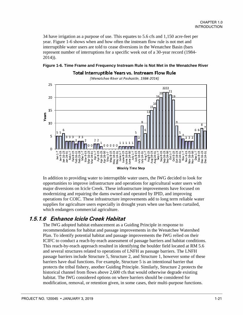
34 have irrigation as a purpose of use. This equates to 5.6 cfs and 1,150 acre-feet per
year. Figure 1-6 shows when and how often the instream flow rule is not met and
interruptible water users are told to cease diversions in the Wenatchee Basin (bars
represent number of interruptions for a specific week out of a 30-year record (1984-
2014)).
Figure 1-6. Time Frame and Frequency Instream Rule is Not Met in the Wenatchee River
In addition to providing water to interruptible water users, the IWG decided to look for
opportunities to improve infrastructure and operations for agricultural water users with
major diversions on Icicle Creek. These infrastructure improvements have focused on
modernizing and repairing the dams owned and operated by IPID, and improving
operations for COIC. These infrastructure improvements add to long term reliable water
supplies for agriculture users especially in drought years when use has been curtailed,
which endangers commercial agriculture.
1.5.1.6 Enhance Icicle Creek Habitat The IWG adopted habitat enhancement as a Guiding Principle in response to
recommendations for habitat and passage improvements in the Wenatchee Watershed
Plan. To identify potential habitat and passage improvements the IWG relied on their
ICIFC to conduct a reach-by-reach assessment of passage barriers and habitat conditions.
This reach-by-reach approach resulted in identifying the boulder field located at RM 5.6
and several structures related to operations of LNFH as passage barriers. The LNFH
passage barriers include Structure 5, Structure 2, and Structure 1, however some of these
barriers have dual functions. For example, Structure 5 is an intentional barrier that
protects the tribal fishery, another Guiding Principle. Similarly, Structure 2 protects the
historical channel from flows above 2,600 cfs that would otherwise degrade existing
habitat. The IWG considered options on where barriers should be considered for
modification, removal, or retention given, in some cases, their multi-purpose functions.

ICICLE CREEK SUBBASIN
PROGRAMMATIC ENVIRONMENTAL IMPACT STATEMENT
1-22 PROJECT NO. 120045 JANUARY 3, 2019
Additionally, the group identified several habitat improvement opportunities in lower
Icicle Creek and the historical channel (Reach 4 and Reach 5). Chelan County and the
IWG have commissioned more habitat and passage studies to identify and prioritize
habitat restoration and passage improvement projects, which are discussed in the Lower
Icicle Creek Geomorphic and Hydraulic Assessment for the Identification of Protection
and Restoration Actions prepared by Natural Systems Design for the County (Natural
Systems Design, 2017).
1.5.1.7 Comply with State and Federal Law, and Wilderness Acts All actions taken by the IWG must comply with state and federal law. All members of the
Work Group agreed that a project cannot move forward if it is out of compliance with
laws. Laws of specific interest include:
• The Wilderness Act
• The Alpine Lakes Area Management Act
• The Clean Water Act
• Magnuson-Stevens Fishery Conservation and Management Act
• Fish and Wildlife Coordination Act
• National Historic Preservation Act
• Chapter 90.03 RCW – State Surface Water Code
• Chapter 90.44 RCW – State Groundwater Code
• Chapter 77.57 RCW – Fishways, Flow, and Screening
Table 5-22 in Chapter 5 provides a complete list of permits and laws applicable to the
proposed projects under the Icicle Strategy, and Section 1.9 describes permits, actions,
and laws related to the Icicle Strategy.
1.5.2 Final Guiding Principles
The result of the processes described above was the fine-tuning of the Guiding Principles
into what they are today. As discussed above, this involved combining some principles,
adding qualitative descriptions, and adding quantitative metrics. Below is the description
of the IWG’s Guiding Principles today, after 3-years of scientific study and negotiation.
1.5.2.1 Improve Instream Flow This principle seeks to improve and enhance instream flows in the Icicle Creek historical
channel. The goal is to modulate the flow in a way that enhances fish passage, fish life
and promotes healthy habitats, serves channel formation function, meets aesthetic and
water quality objectives, and is resilient to climate change.
The metric for this principle calls for drought year and non-drought year minimum flows,
as well as an interim and long-term flow restoration goal.
During drought years, the instream flow goal is set at 60 cfs. To meet drought year goals,
a minimum of 40 cfs will need to be protected instream, assuming a drought year base
flow of 20 cfs.

CHAPTER 1.0
INTRODUCTION
PROJECT NO. 120045 JANUARY 3, 2019 1-23
The short-term, non-drought year goal is 100 cfs minimum flows, which would provide
90-percent WUA for steelhead. The long-term goal was set was at 250 cfs (100 percent
WUA for steelhead). A maximum flow of 2,600 cfs can pass through Structure 2. Based
on work conducted by the IWG’s Instream Flow Subcommittee, this flow maximum will
remain in place to preserve habitat function.
1.5.2.2 Improve Sustainability of LNFH This principle aims to enhance and maintain a healthy, sustainable LNFH that produces
fish in adequate numbers to meet U.S. v. Oregon, which specifies fish production
requirements. Meeting this goal requires sufficient, diverse water source availability to
maximize fish health, with groundwater supplies providing cool, pathogen free water.
This principle calls for a 57 cfs supply for fish production from groundwater and surface
sources. This principle also calls for LNFH to conserve at least 20 cfs compared to
current usage. It also includes appropriately screened diversions and minimizing
unintended barriers to fish passage.
1.5.2.3 Protect Treaty/Non-treaty Harvest Treaty harvest by the Yakama Nation, the Colville Confederated Tribes, and non-treaty
fishing are important parts of the Icicle Creek Subbasin. This principle maintains that
tribal and non-tribal, federally protected fishing and harvest rights must be met at all
times regardless of season or drought conditions. It aims to improve the CPUE and
maintain multispecies harvest opportunities.
As part of this principle, the IWG is developing a Tribal Impacts Assessment and
Adaptive Management Plan that addresses attraction flows, sediment transport, fish
migration/straying, and site access and amenities.
1.5.2.4 Improve Domestic Supply As the population inside the Icicle Creek Subbasin grows, more water will be needed by
the City of Leavenworth and surrounding areas in Chelan County. This principle calls for
1,750 acre-feet of reliable year-round supply, with 2.5 to 5 cfs for peaking. Additionally,
this principle aims to improve domestic reliability for rural water users in the Icicle Creek
Subbasin who depend on domestic wells to supply their drinking water.
1.5.2.5 Improve Agricultural Reliability With agriculture vital to the economic health and prosperity of the region, this principle
calls for projects to improve agricultural reliability that are operational, flexible, decrease
risk of drought impacts, and are economically sustainable. It ensures current interruptible
agricultural users have a firm supply in average water years.
1.5.2.6 Enhance Icicle Creek Habitat This principle seeks to improve ecosystem health by protecting and enhancing aquatic
and terrestrial habitat in the Icicle Creek Subbasin. This includes investments in physical
habitat improvements that consider high-flow habitat and low-flow refuge, along with
minimizing impediments to fish passage and improving limiting factors for
spawning/rearing. It also offsets project-related terrestrial impacts with land
acquisitions/easements.

ICICLE CREEK SUBBASIN
PROGRAMMATIC ENVIRONMENTAL IMPACT STATEMENT
1-24 PROJECT NO. 120045 JANUARY 3, 2019
1.5.2.7 Comply with State and Federal Law, and Wilderness Acts Projects developed under the Icicle Strategy must comply with both Washington State
and federal laws, including the Wilderness Act of 1964, the Alpine Lakes Wilderness Act
of 1976, and the Alpine Lakes Wilderness Management Plan of 1981. The IWG actively
identified and engaged regulators in the process of creating the alternatives and projects
for the Icicle Strategy. Section 1.9 provides a more detailed description of applicable
permits and laws.
1.5.3 Current Water Resources Conditions in the Icicle
Subbasin
Seasonal low flows in lower Icicle Creek between the major diversions and the hatchery
return are a common problem. Figure 1-7 shows low flow conditions that commonly
occur during late summer. These low flows diminish water quality and limit habitat
diversity for salmonids and are the leading issues in the Icicle Creek Subbasin. Water
withdrawals in Icicle Creek (primarily between Rat Creek and the hatchery) likely
contribute to low flows and high summer temperatures in lower Icicle Creek. Icicle Creek
has exceeded state and federal water quality standards for temperature and dissolved
oxygen (DO)/pH. Salmonid populations are at risk because of limited habitat diversity
and quantity, obstructions, and increased sediment loads. The change in the landscape
and vegetation after the 1994 Rat Creek Fire has contributed to increased sediment loads
in Icicle Creek (MWG, 2006).
Figure 1-7. Low Flows at Structure 2 in 2001 (20 cfs)

CHAPTER 1.0
INTRODUCTION
PROJECT NO. 120045 JANUARY 3, 2019 1-25
As described in the previous section, Chapter 173-545 WAC sets flow requirements in lower
Icicle Creek. Additionally, Chapter 173-545 WAC provides for a reservation of water for
future uses. Based on Chapter 173-545 WAC, the control point for stream flow targets in the
Icicle Subbasin is at the East Leavenworth Bridge. This control point is monitored by
Ecology Gage 45B070. There is also a USGS gage located upstream of the major water right
diversion at RM 5.8. All water rights issued after the establishment of the instream flow rule
are considered junior to the rule and must not be exercised when instream flows at the
Ecology gage are not met (unless the water right is debited from the reserve).
1.6 Prior Investigations and Activities in the Icicle
Basin
This PEIS builds on a foundation of historical planning and scientific studies completed
in the Icicle Subbasin. The following sections provide brief summaries of this work,
which is incorporated by reference into this evaluation. The References section at the end
of this document can be used to obtain greater detail.
1.6.1 Watershed Plan
As previously discussed, the Washington State Legislature passed the Watershed
Management Act (formed under ESHB 2514; Chapter 90.82 RCW) in 1998. Chelan
County, the Wenatchee Reclamation District, and the City of Wenatchee assembled late
in 1998 and determined they would pursue watershed planning under Chapter 90.82
RCW. The Wenatchee Watershed Planning Unit (WWPU) formed in 1999; Chelan
County was designated Lead Agency for grant management purposes and to provide
administrative, facilitation, and technical support to the process. Participation on the
WWPU has always been open to include “anyone who has an interest in the Wenatchee
River Watershed” (WWPU, 2003). Active Planning Unit members are grouped as
governmental or non-governmental based on their ability to implement specific and
tangible elements of the plan. Much of the watershed planning work in WRIA 45 has
been (and continues to be) performed by several key technical subcommittees under the
direction of the Planning Unit. These committees address technical and policy issues
associated with each of the technical elements and develop alternative approaches for the
Planning Unit’s consideration. The Water Quantity/Instream Flow/Water Storage, Water
Quality, and Habitat Technical Subcommittees include a broad range of representation
from those with special technical expertise or an interest in the subject area.4
The Wenatchee Planning Unit produced the Wenatchee Watershed Plan in 2006. This
plan identifies issues with water quality, water quantity, instream flow, and habitat within
the watershed and provides recommendations for addressing those issues. The Planning
Unit produced a Detailed Implementation Plan in 2008 to provide implementation
pathways for the recommendations in the Watershed Plan. The Planning Unit has also
commissioned several reports and studies to address water management in the basin.
4 http://www.co.chelan.wa.us/files/natural-
resources/documents/Planning/Wen_Planning/Wen_Watershed_Plan/text/final_watershed_plan.pdf

ICICLE CREEK SUBBASIN
PROGRAMMATIC ENVIRONMENTAL IMPACT STATEMENT
1-26 PROJECT NO. 120045 JANUARY 3, 2019
1.6.2 Biological Opinion
In 2006, a Biological Assessment (BA) for Operation and Maintenance of LNFH was
conducted by the U.S. Fish and Wildlife Service (USFSWS, 2006). The focus of the BA
was to provide updated information on the hatchery’s operation and maintenance, and an
updated assessment on the potential effects of the hatchery on federally listed, proposed,
and candidate species as well as designated critical habitat. The BA outlined the project
location, affected action area, foreseeable future actions in the Icicle Creek Watershed
(including the Icicle Creek Restoration Project and LNFH’s Water Supply System
Rehabilitation Project), operation and maintenance of the LNFH (historical and current),
description of species and critical habitat, current condition of the habitat, integration of
species and habitat condition, analysis of potential effects to ESA-listed species, analysis
of potential effects to the current condition of the habitat, cumulative effects, and effect
determination and response requested. The critical species and habitat included bull trout.
The BA included an assessment of the current condition of the habitat, including water
quality, habitat access and elements, channel condition and dynamics, flow and
hydrology, and watershed conditions. The results of the assessment indicated that of the
species and habitat considered, the bull trout habitat had an indicator of degraded and was
determined to be adversely affected by current LNFH operations. This resulted in formal
consultation with National Marine Fisheries Service (NMFS).
Consultation with NMFS resulted in a Biological Opinion published in May 2015. Key
proposed operations, maintenance, and construction at LNFH required in this Biological
Opinion included:
• Install recirculating aquaculture system (RAS) tanks to reduce surface water needs
• Reduce surface water diversions by as much as 20 cfs annually
• Work towards collective instream flow goal of 100 cfs in Icicle Creek
• Evaluate to determine the efficiency and scope of expanded use of Snow Lake and
Nada Lake Supplemental Reservoirs as a means to ensure flow for the LNFH’s
surface water right and improve instream flows outside of the current
supplementation period
• Reduce use of Structure 2 for recharge by exploring effluent pump back and
development of well fields
• Discontinue use of Structure 2 for aquifer recharge in August
• Limit diverted quantities at Structure 2 if certain flow requirements aren’t met in
September
• Limit use of Structure 2 in March when adult steelhead are detected
• Screen Structure 1 so it meets current NMFS screening standards
Many of these elements were integrated into the Guiding Principle for a sustainable
LNFH (Section 2.1.2.2). The Biological Opinion set an 8-year timeline to accomplish
these upgrades.

CHAPTER 1.0
INTRODUCTION
PROJECT NO. 120045 JANUARY 3, 2019 1-27
LNFH and NMFS re-opened consultation and prepared a new Biological Opinion as a
result of the Wild Fish Conservancy v. Irving case, which concluded in the U.S. District
Court, Eastern District of Washington remanding the Biological Opinion for not fully
considering climate change. This Biological Opinion was released by NMFS in 2018.
1.6.3 Habitat, Passage and Instream Flow Studies
Several entities have worked on or commissioned reports regarding fisheries and
instream flows in the Icicle Subbasin. These entities include Chelan County, Ecology,
LNFH, as well as numerous local and non-profit organizations. These investigations are
summarized in this section. Full reports can be accessed from Chelan County’s Icicle
Work Group webpage.5
1.6.3.1 Icicle Water Temperatures (All Reaches) There are several salmonid species in lower Icicle Creek that could be impacted by
changes in water temperature. Bull Trout require cooler water than most other salmonid
species, preferring temperatures between 9 and 13 C. Other salmonids found in lower
Icicle Creek have a tolerance for higher temperatures, being found in waters up to 22 C
(Ringel, 2007).
USFWS’ Mid-Columbia River Fisheries Resource Office (MCRFRO) has monitored
water temperature in Icicle Creek since 2005 when Ecology set a TMDL for temperature
to evaluate the impact of LNFH operations on stream temperatures (Ecology, 20056;
Fraser, 2015). Temperature loggers are deployed upstream, adjacent, and downstream of
LNFH and in two tributary streams (Snow Creek and Jack Creek) (Hall and Kelly-Ringel,
2011).
For the Wenatchee Basin, mean summer and 7-Day Average Daily Maximum
(7DADmax) values were calculated for each site and day using the running average of
the previous 7 days (Hall and Kelly-Ringel, 2011). Between 2005 and 2010, the warmest
mean high 7DADmax overall was 20.4 C (range 19.4 to 22.1 C), occurring in the
Wenatchee River. The warmest mean high 7DADmax within Icicle Creek was 19.4 C
(range 18.9 19.8 C), occurring downstream of the LNFH. The warmest mean high
7DADmax upstream of LNFH influence was 18.5 C (range 17.4 to 19.8 C) occurring
upstream of Snow Creek.
The summer season coolest mean high 7DADmax of 15.8 C (range 14.7 to 17.3 C)
occurred in Jack Creek. Within the LNFH operational influence, the summer season
coolest mean high 7DADmax of 16.9 C (range 16.2 to 18.3 C) occurred in the LNFH
spillway pool. In Snow Creek, the mean high 7DADmax for the years sampled was
17.3 C (range 15.9 to 18.5 C).
1.6.3.2 Instream Flow Study and Report for Icicle Creek (Reach 1) In 1985, the U.S. Army Corps of Engineers produced an instream flow study in support
of a hydropower feasibility study on Icicle Creek. This study used Instream Flow
Incremental Methodology (IFIM) to study flows and consider the potential impacts to
5 http://www.co.chelan.wa.us/natural-resources/pages/icicle-work-group?parent=Planning 6 https://fortress.wa.gov/ecy/publications/documents/0503011.pdf

ICICLE CREEK SUBBASIN
PROGRAMMATIC ENVIRONMENTAL IMPACT STATEMENT
1-28 PROJECT NO. 120045 JANUARY 3, 2019
fish habitat that could occur as a result of changes in instream flow caused by the
potential project. The primary species of interest for this report were rainbow trout,
cutthroat trout, brook trout, and bull char (bull trout). The results found that some
spawning and juvenile habitat occurs in Reach 1 for all species listed above. Table 1-5
provides details of optimum flows for each species in Reach 1.
Table 1-5
Optimum Flows by Species and Life Stage for Reach 1
Species Life Stage Optimum Flow (cfs; approx.)
Rainbow Trout Spawning 400
Adult 500
Juvenile 200
Cutthroat Trout Spawning 400
Adult 250
Juvenile 200
Brook Trout Spawning 400
Adult 100
Juvenile 100
Bull Trout Spawning 400
Adult 125
Juvenile 125
Whitefish Spawning 300
Adult 500
Juvenile 200
Steelhead Spawning 400
Adult -
Juvenile 200
Spring Chinook Spawning 250
Adult -
Juvenile 175
1.6.3.3 Icicle Creek Boulder Field Fish Passage Assessment (Reach 2) In 2013, EcoAssets and Trout Unlimited produced an assessment of passage at the
boulder field (RM 5.6). The purpose of this study was to document the extent of
anthropogenic impact on fish passage and identify fish passage options at this location.
The study found that the “Anchor Boulder”, which is the largest boulder in the boulder
field, is the primary impediment to passage in this reach. The study also found evidence
that there are anthropogenic impacts on the development of the boulder field and
suggested several alternatives to improve passage, including channel profile adjustment,
roughened channel, various types of fishways, and constructed riffle.
1.6.3.4 Icicle Creek Target Flows (Reach 3) Montgomery Water Group produced a report in 2004 for LNFH on target flows. The
purpose of the report was to summarize the analysis of target flows for the reach of Icicle
Creek downstream of the LNFH diversion (Reach 3) because of low flows during late
summer. The primary concerns with flow through this reach were passage and rearing
habitat. This study found that passage is likely in Reach 3 at flows as low as 20 cfs,
CHAPTER 1.0
INTRODUCTION
PROJECT NO. 120045 JANUARY 3, 2019 1-29
which was consistent with the findings of a similar report produced in 2001 (USFWS,
2001). This study also found that maximum habitat benefit was likely for adult and
juvenile bull trout and steelhead at 291 cfs. However, an optimal flow was not estimated
for this reach because of data gaps.
1.6.3.5 Icicle Creek Fish Passage Evaluation for the Leavenworth National Fish Hatchery (Reach 4)
In 2013, the U.S. Fish and Wildlife Service conducted a fish passage evaluation for the
LNFH to characterize physical and hydraulic conditions associated with a range of
streamflow’s at Structures 1, 2, and 5, and open-channel flows in the historical channel in
Icicle Creek adjacent to the LNFH (Anglin et al., 2013). These structures are used to
operate LNFH: Structure 1 is the surface water diversion located at RM 4.5, Structure 2
bifurcates flows at RM 3.9 to direct part of Icicle Creek into the hatchery channel for
groundwater recharge and some into the historical channel, and Structure 5 is a barrier
structure operated for broodstock collection and to impede upstream migration during
tribal harvest.
Results of this study indicated variable limitation of fish passage associated with unique
conditions involved with each structure or location. Passage criteria, species periodicity,
and stream flows ranging from 90 percent to 10 percent exceedance flow (Icicle Creek)
were integrated by month to identify depth and velocity passage limitations at the
structures and in the historical channel. Detailed tables were generated to allow managers
and stakeholders to determine when passage limitations occur, and whether options exist
to eliminate barriers or improve passage conditions at these sites. Because fish passage is
not a binary situation, interpretation of the results and development of improved fish
passage options should be conducted jointly by technical experts, managers, tribes and
other stakeholders to determine actions that will meet the multiple goals for Icicle Creek.
Key outcomes of this study included the installation of independent radial gates and the
re-operation of Structure 2 to improve passage, continuation of capturing and moving
non-target fish species at Structure 5, as well as velocity targets at both structures.
Additionally, this report suggested improvements to the design and location of the
fishway at Structure 1 and recommended maintaining 60 cfs in the historical channel for
improved passage conditions.
1.6.3.6 Lower Icicle Creek Reach Assessment (Reach 5) In 2005, USBR produced an Instream Flow Assessment of Icicle Creek, Washington. The
purpose of the study was to characterize the relationship between stream flow and fish
habitat in Icicle Creek downstream from the LNFH (Reach 5). This assessment included
a Physical Habitat Simulation (PHABSIM) and IFIM to assist the Planning Unit with
instream flow recommendations for Icicle Creek. The primary outcome of this report was
WUA charts for each life stage and species of interest. The study found optimum flow
between 70 cfs (bull trout) and 670 cfs (steelhead) for spawning species of interest, and
approximately 50 cfs (bull trout) and 240 cfs (steelhead) for juvenile species of interest.
In 2017, a geomorphic and hydraulic assessment of the lower 4.3 miles of Icicle Creek,
starting from the confluence with the Wenatchee River and extending up-valley through
the Historic Channel at the LNFH, was completed to provide a scientific basis for
identification and development of stream restoration and protection actions for lower

ICICLE CREEK SUBBASIN
PROGRAMMATIC ENVIRONMENTAL IMPACT STATEMENT
1-30 PROJECT NO. 120045 JANUARY 3, 2019
Icicle Creek (NSD, 2017). The assessment included a review of background information,
field surveys, and computer modeling to characterize existing conditions. Hydraulic
modeling used to evaluate reach hydraulics and floodplain connectivity incorporated
bathymetric survey data and floodplain topography based on 2015 LiDAR data. Habitat
Suitability Modeling examined the value of existing habitats related to juvenile Chinook
salmon and steelhead rearing, and adult steelhead spawning.
Results of this assessment found that rearing habitat in lower Icicle Creek is poor and
limited by lack of cover due to widespread loss of large wood in the system and lack of
connectivity to off-channel habitat areas during high flows. The assessment identifies and
prioritizes project opportunities by sub-reach designed to protect existing floodplain,
increase rearing habitat by providing cover and improving floodplain connectivity, and
restore riparian vegetation.
1.6.4 Climate Change
The IWG is considering whether the Guiding Principles can be met in response to long-
term changes in water supply associated with climate change. Four climate change
evaluations are considered in this PEIS, including work by USFS, OCR/WSU, the Icicle
Watershed Council/Trout Unlimited, and the UW Climate Impacts Group. Below is a
summary of these reports. Section 3.12 discusses climate in more depth.
1.6.4.1 USFS Report The USFS published a report on climate change in the North Cascades region in 2014 to
better understand upcoming resource management issues related to climate change in the
North Cascades. In the Pacific Northwest, the current warming trend is expected to
continue, with average warming of 2.1 °C by the 2040s and 3.8 °C by the 2080s;
precipitation may vary slightly, but the magnitude and timing are uncertain. This
warming will have far-reaching effects on aquatic and terrestrial ecosystems. Hydrologic
systems will be especially vulnerable as North Cascades watersheds become increasingly
rain dominated, rather than snow dominated, resulting in more autumn/winter flooding,
higher peak flows, and lower summer flows. This will greatly reduce suitable fish habitat,
especially as stream temperatures increase above critical thresholds. In forest ecosystems,
higher temperatures will increase stress and lower the growth and productivity of lower
elevation tree species on both the western and eastern sides of the Cascade crest, although
growth of high elevation tree species is expected to increase. Distribution and abundance
of plant species may change over the long term, and increased disturbance (i.e., wildfire,
insects, and invasive species) will cause rapid changes in ecosystem structure and
function across broad landscapes, especially on the east side of the Cascades. This in turn
will alter habitat for a wide range of animal species.
1.6.4.2 Columbia River Basin Long-term Supply and Demand Forecast Report
OCR has a legislative mandate to produce a Supply and Demand Forecast once every 5
years to understand future water supplies and demands that factors in changes to climate,
regional and global economics, Columbia River hydrology and hydropower operations
and irrigation practices/technology. Previous editions were published in 2006 and 2011.

CHAPTER 1.0
INTRODUCTION
PROJECT NO. 120045 JANUARY 3, 2019 1-31
This section focuses on the 2016 report that provides a forecast to help OCR strategically
fund water supply projects by improving understanding of where additional water supply
is most needed, now and in the future. This most recent forecast offers a generalized,
system-wide assessment of how future environmental and economic conditions will
likely change water supply and demand over the next 20 years. The report evaluates
surface water supply and demand for the Columbia River Basin, including the Wenatchee
Basin. The impacts of climate change, regional and global economic conditions, and
state-level water management actions on surface water supplies and irrigation demands
were evaluated. Irrigation, municipal, and hydropower demands were forecasted, as well
as instream flow requirements for fish stock status and habitat utilization, fish habitat
condition, and stream flow. These evaluations were made for the entire Basin as well as
by WRIAs. The current and future forecasts will build on and expand current knowledge
and understanding and serve as a planning tool to maintain and enhance the region’s
economic, environmental, and cultural prosperity.
Icicle Creek is in WRIA 45 (Wenatchee). The tributary surface water forecast for WRIA 45
is characterized by substantial increases in flow from fall through early spring, and
decreases in flow in June and July. Instream flow requirements are the largest water
demand, with smaller irrigation demand and even smaller municipal demand. In WRIA 45,
the Supply and Demand Forecast predicts a shift in crops, which will increase irrigation
demand in May and decrease demand in late summer and fall, with little change in June
and July. Modeling of curtailment of interruptible irrigation water rights indicated that
curtailment occurred in 90 percent of the years between 1977 and 2006. The forecast shows
more frequent and higher magnitude of curtailment events during the early irrigation
season. Additionally, there is a predicted 11 percent increase in demand by 2035.
1.6.4.3 Icicle Creek Watershed Council Icicle Creek Watershed Council (ICWC) has conducted several studies examining the
water budget in response to climate change. This work assumed a 35 percent decrease in
streamflow (compared to 1994) as a result of climate change. This research found that
reductions in streamflow would require additional inputs of up to 60 cfs in September, a
critical low flow month, to offset the impacts of climate change in Icicle Creek.
Examining the storage available in the upper Icicle Creek Watershed, the ICWC
concluded that supplying 60 cfs from storage was possible to offset impacts of climate
change with the assumed 35 percent decrease in streamflow.
1.6.4.4 UW Climate Impacts Group Icicle Creek Study UW Climate Impacts Group issued a report in 2017 that examines the changing
streamflow in Icicle and Peshastin Creeks as the result of climate change. This analysis
used off-the-shelf hydrologic climate change data sets. The objective was to develop
estimates of projected changes in monthly streamflow for the seven alpine lakes and
changes in daily streamflow for Icicle and Peshastin Creeks. Projections for the alpine
lakes have allowed the IWG to assess how the alternatives perform under current and
future climate conditions, which is discussed in detail in Section 3.12 and 4.12. The goal
described in the Guiding Principles appear attainable based on this analysis, therefore
additional refinement of the models did not occur at this stage of analysis. The daily flow
projections allow an understanding of changes in extremes (high and low flows) and their
implications for water management.

ICICLE CREEK SUBBASIN
PROGRAMMATIC ENVIRONMENTAL IMPACT STATEMENT
1-32 PROJECT NO. 120045 JANUARY 3, 2019
1.6.5 Water Storage
1.6.5.1 Water Storage Report, Wenatchee River Basin This report provided a summary of potential water storage projects and other water
resource management strategies intended to increase water supply and instream flow in
the Wenatchee River Basin. The Wenatchee River Basin is part of Ecology’s WRIA 45,
which is expressed by the drainage basin for the Wenatchee River. The primary water
needs in the Wenatchee River Basin include irrigation, municipal and domestic water
supply, and instream flows for fish passage and habitat. This report builds on information
provided in the Multi-Purpose Water Storage Assessment in the Wenatchee River
Watershed (MWG 2006) and other planning studies that have identified opportunities for
improved management of water resources in the Wenatchee River Basin. A comparison
of the costs and benefits of potential water storage projects with other water management
strategies, such as water conservation on irrigation systems and acquisition of water
rights, is also included. This report was prepared for Chelan County under a grant from
the Columbia River Water Management Development Account administered by Ecology.
This report provides a preliminary summary of potential water storage projects and other
water resource management strategies intended to improve the availability of water in the
Wenatchee River Basin for both instream and out of stream water needs. This section
includes a brief summary of the projects and strategies that were evaluated in this report.7
1.6.5.2 Needs and Alternatives Analysis The Needs and Alternatives Analysis for Icicle Creek Subbasin Storage Study (2007),
reviewed reach-by-reach water supplies and demands in the Subbasin. This analysis split
Icicle Creek into four reaches. Work by the IWG recognizes five reaches, splitting the
reach identified as Reach 3 in this study into two separate reaches, with Structure 2 being
the new dividing point. Water needs were estimated by comparing the available water
supply to the water demands in the Icicle Subbasin. The water demands include irrigation
diversions, municipal and domestic demand, LNFH diversions, and instream flows.
Reach 1, the most upstream reach of Icicle Creek, has little demand because of lack of
population in this reach and no other diversions. The primary water demand is the
instream flow needs. A surplus of water occurs during the spring melt, while a deficit
occurs in August through October during the period of annual low flows. However, the
flows in this reach are natural and slightly enhanced by discharge from high alpine lakes
operated by the Icicle and Peshastin Irrigation District.
Reach 2 has a large seasonal demand coming from the Icicle and Peshastin Irrigation
Districts at their diversion dam (RM 5.7). Reach 2 also contains the City of
Leavenworth’s surface water diversion (RM 5.7). Snow Creek flows into Icicle Creek in
this reach and its water supply was added to the water supply provided by Icicle Creek. A
surplus of water occurs during the spring melt, while a deficit occurs in August through
October during the period of annual low flows. Slight deficits also occur in January
through April. The primary need is for additional water in August and September.
7 http://www.co.chelan.wa.us/files/natural-
resources/documents/Planning/icicle_work_group/Basin_Wide_Studies/2011WenStorageRpt.pdf

CHAPTER 1.0
INTRODUCTION
PROJECT NO. 120045 JANUARY 3, 2019 1-33
Reach 3 has a large demand from the LNFH and a seasonal demand from the Cascade
Orchards Irrigation Company (both at RM 4.5). This reach spans the IWG reaches
identified as Reach 3 and Reach 4. Although the LNFH demand is non‐consumptive,
Reach 3 flow is reduced. This document provides proposed flows for Icicle Creek and do
not represent the flow that may be provided by LNFH in this reach as a result of
negotiations with USFWS and NOAA Fisheries.
Reach 4 has no major diversions but all non‐purveyor domestic water use, and all non‐district irrigation use are assumed to take water from Icicle Creek in this reach because
the majority of the population is located within this reach. The LNFH outflow adds
supply to Icicle Creek at RM 2.7. Domestic irrigation demands are small enough that
neither can be visibly seen on the graph. A surplus of water occurs during the spring melt,
while deficits occur in August through October during the low flow period. Deficits also
occur during the February through April time period due to icing. The primary need is for
additional water in August and September.8
1.6.6 IPID Pump Exchange
A Pump Exchange project was examined as an alternative water supply to the Icicle and
Peshastin Irrigation Districts, moving their Icicle Creek diversion to the Wenatchee
River, which would increase streamflow in Icicle and Peshastin Creeks downstream of
the current diversions. In 2012, Anchor QEA produced the Peshastin Irrigation District
(PID) Pump Exchange Project Appraisal Study (Anchor, 2012) which evaluated five
alternatives and selected a preferred alternative (Alternative 1) along with a second
(Alternative 5) as a backup. In 2014, Forsgren and Associates produced a report for Trout
Unlimited examining six pump station locations for IPID, including those examined in
the Anchor report and additional locations at Monitor, the Cashmere Wastewater
Treatment Plant, the Cashmere Mill Site, and at the Dryden Reclamation District
Diversion. In 2015, Anchor QEA attempted to combine the findings of these studies into
a report titled Summary of Additional Analysis, Icicle and Peshastin Irrigation Districts
Pump Exchange (Anchor, 2015). The two most feasible plans proposed to pump water
from the Wenatchee River immediately west of Dryden, Washington and near
Leavenworth, Washington. Although both plans had pros and cons, they were both
estimated to cost approximately $8.5 million.
Chelan County received grant funding in 2016 from the Salmon Recovery Funding Board
to proceed with preliminary design and feasibility of the pump station. The work
proposed under this grant would result in preliminary design of a preferred pump
exchange project that would deliver water from the Wenatchee River to the PID Canal to
provide instream flow benefit in Peshastin Creek during the late summer. The
preliminary design would consider the potential for designing the project to be scalable to
expand delivery to IID to benefit Icicle Creek in the future, if appropriate. The
preliminary design work would also evaluate operations and determine whether
supplemental flows from the IID Canal could be reduced and whether operational
discharges of Icicle Creek water to Peshastin Creek could be reduced.
8 http://www.co.chelan.wa.us/files/natural-
resources/documents/Planning/icicle_work_group/Icicle_Studies/DraftNeedsandAlts.pdf

ICICLE CREEK SUBBASIN
PROGRAMMATIC ENVIRONMENTAL IMPACT STATEMENT
1-34 PROJECT NO. 120045 JANUARY 3, 2019
1.7 Fish Recovery Efforts
The Wenatchee Watershed is home to a variety of aquatic species, including the
following salmonids: spring- and summer-run Chinook salmon (Oncorhynchus
tshawytscha), sockeye salmon (O. nerka), steelhead/rainbow trout (O. mykiss), westslope
cutthroat trout (O. clarki lewisi), and migratory and resident bull trout (Salvelinus
confluentus). The documented, presumed, and potential distributions of anadromous
salmonids in the Icicle Creek Subbasin are shown in Figure 1-8. Pacific lamprey
(Entosphenus tridentatus) and re-introduced coho salmon (O. kisutch), two species of
cultural importance to the Yakama Nation and Colville Confederated Tribes, are also
present in the Wenatchee Basin.
Much of the planning, protection, and restoration/enhancement work in WRIA 45 has
focused on the needs of salmonids listed under the ESA. Upper Columbia River spring-
run Chinook salmon were listed as endangered in 1999 (64 FR 14308), Upper Columbia
River steelhead were listed as endangered in 1997 (62 FR 43937) and reclassified as
threatened in 2006 (71 FR 834), and Columbia River bull trout were listed as threatened
in 1998 (63 FR 31647). NOAA Fisheries adopted the Upper Columbia Spring Chinook
and Steelhead Recovery Plan (UCSRB, 2007) as its recovery plan for these species.
Table 1-6 provides a list of priority projects from the recovery plan, as identified in
appendix M1 of the report. As illustrated in the status column, the IWG and their partners
have completed several of the identified projects. The USFWS finalized its recovery plan
for bull trout in 2015 (USFWS, 2015).

CHAPTER 1.0
INTRODUCTION
PROJECT NO. 120045 JANUARY 3, 2019 1-35
Figure 1-8. Icicle Creek Subbasin Distributions of Anadromous Salmonids

ICICLE CREEK SUBBASIN
PROGRAMMATIC ENVIRONMENTAL IMPACT STATEMENT
1-36 PROJECT NO. 120045 JANUARY 3, 2019
Table 1-6
Icicle Creek Projects Identified in the Upper Columbia Spring Chinook and Steelhead
Recovery Plan
Project Name Status Ecological Concern
USFWS LNFH Icicle Creek Restoration Project Active 1 Habitat Quantity - Anthropogenic Barriers
ICTU Icicle Creek Reach Level Analysis Completed
CCNRD Icicle Revegetation Completed 4 Riparian Condition - Riparian Vegetation
CCNRD Wenatchee Instream Flow Habitat Project
Completed
CDLT Lower Icicle Creek Habitat Conservation Completed 5 Peripheral and Transitional Habitats - Floodplain Condition
CDLT Icicle Creek Conservation Opportunities Outreach
Completed
CCNRD Lower Icicle Riparian Initiative Completed 4 Riparian Condition - Riparian Vegetation
TU-WWP Icicle Creek Alternatives Analysis Conceptual 9 Water Quantity - Decreased Water Quantity
CDLT Icicle Creek Copper Notch Conservation Easement
Completed 5 Peripheral and Transitional Habitats - Floodplain Condition
USFS Icicle Creek Minimum Roads Analysis and Road System Improvements
Proposed
CCNRD Icicle Irrigation District Efficiencies Proposed
CDLT Lower Wenatchee Leavenworth Audubon Center Acquisition
Completed 5 Peripheral and Transitional Habitats - Floodplain Condition
TU-WWP - Icicle Creek Boulder Field Assessment
Completed 1 Habitat Quantity - Anthropogenic Barriers
CCFEG Salmon Lifecycle Landscape Completed
TU-WWP Icicle Boulder Field Passage Design Proposed
1.8 Litigation Related to Water Management in the
Icicle Creek Subbasin
Several water management challenges and conflicts have led to the development of the
IWG and subsequently the Icicle Strategy, as laid out throughout this chapter. Many of
these issues revolve around conflict over limited water resources, insufficient instream
flows, and the need to meet future water demand. These conflicts have led the IWG to
believe an integrated water resource management approach is the best option to address
insufficient streamflow and conflict over water rights. Below is a synopsis of some of this
conflict bared out through past litigation in the Icicle Creek Subbasin.

CHAPTER 1.0
INTRODUCTION
PROJECT NO. 120045 JANUARY 3, 2019 1-37
City of Leavenworth v. Washington State Department of Ecology
The City of Leavenworth’s surface water certificate authorizes an instantaneous quantity (Qi)
of diversion of 1.5 cfs from Icicle Creek. According to the City, the certificate does not list a
specific time limit or maximum annual quantity (Qa) and contends that the Qa should be 1,085
acre-feet per year, which is based upon year-round, continuous diversion. Ecology states the
City of Leavenworth has previously agreed to limit Qa to 275 acre-feet per year based upon a
prior settlement before the PCHB. The City of Leavenworth filed a declaratory judgment action
in Chelan County Superior Court seeking a determination of maximum Qa. In 2012, the court
ruled in favor of Ecology, which the City of Leavenworth appealed to the Court of Appeals.
Subsequently, the City of Leavenworth and Ecology have agreed to stay the litigation, or
temporarily put on hold, while Ecology and the City of Leavenworth worked cooperatively to
identify and fund projects in the Wenatchee River Basin that would augment Leavenworth’s
water rights for future growth.
Wild Fish Conservancy v. Salazar et al
USFWS operates a surface water diversion from Icicle Creek to supply water to the
Leavenworth National Fish Hatchery for various uses. In 2009, the Wild Fish Conservancy and
a local resident, Harriet Bullitt, filed a complaint for declaratory and injunctive relief in the
Eastern District of Washington, United States District Court against Kenneth Salazar (in his
official capacity as the Secretary of the United States Department of Interior), USFWS, USBR,
United States Department of Interior (DOI), and LNFH on the basis that they have allegedly
violated the State of Washington’s Water Code by diverting water into the hatchery channel.
The U.S. District Court, Eastern District of Washington, and the Ninth Circuit Court of Appeals
ruled in favor of the defendants (2013).
Wild Fish Conservancy v. Irving et al
Additional litigation has occurred between Wild Fish Conservancy and LNFH regarding the
adequacy of the Biological Opinion. The U.S. District Court, Eastern District of Washington
order granted in part and denied in part the plaintiff’s and defendant’s motions. The court found
that the Biological Opinion was arbitrary and capricious because it failed to discuss the
potential effects of climate change. However, the court sided with LNFH and NMFS regarding
whether an environmental impact statement was required for the Biological Opinion. The
Biological Opinion was remanded back to NOAA to address climate change impacts.
Wild Fish Conservancy v Washington State Department of Ecology
In 2010, Wild Fish Conservancy and Center for Environmental Law and Policy (CELP)
appealed Ecology’s issuance of a Clean Water Act (CWA) Section 401 Certification for LNFH.
Based on this litigation, Ecology rescinded the January 2010 Section 401 Certification and is
currently working on issuing a new certification.
Center for Environmental Law and Policy v. USFWS
In CELP v. USFWS (2016), CELP and Wild Fish Conservancy sued the LNFH for allegedly
operating without an NPDES permit. In this case, the courts found that the hatchery’s National
Pollutant Discharge Elimination System (NPDES) permit expired in 1979, and that the
hatchery has been discharging pollutants into Icicle Creek without an NPDES permit since that
time, in violation of the CWA. A new NPDES permit and 401 Certification was issued in
December 2017. CELP has filed an appeal to the 401 Certification, which is currently pending
before the PCHB (Center for Environmental Policy and Wild Fish Conservancy v. Dep’t of
Ecology and U.S. Fish and Wildlife Service; PCHB No. 17-109.)

ICICLE CREEK SUBBASIN
PROGRAMMATIC ENVIRONMENTAL IMPACT STATEMENT
1-38 PROJECT NO. 120045 JANUARY 3, 2019
1.9 Overview of SEPA Process
SEPA applies to all decisions made by state and local agencies in Washington State. Under
SEPA, one government agency is typically identified as the lead agency for identifying and
evaluating the potential adverse environmental impacts of a proposal. This evaluation is
documented and sent to the public and other agencies for their review and comment.
Under SEPA, project proponents are asked to complete an environmental checklist. The
checklist asks questions about the proposal and its potential impacts on the environment. After
the checklist has been completed, the lead agency reviews it and other information about the
proposal. If more information is needed, the lead agency can ask the applicant to conduct further
studies. Public meetings and outreach events are used to share information about the proposal
and seek feedback from interested parties. When a proponent has gathered and submitted
enough information about their proposal, the lead agency will make a threshold determination:
• A determination of non-significance – also called a DNS – if it finds the proposal is
unlikely to have a significant adverse environmental impact.
• A determination of significance if the information indicates the proposal is likely to have
a significant adverse environmental impact. This requires the preparation of an EIS that
evaluates the environmental impacts of the proposal and reasonable alternatives.
• A determination of mitigated non-significance – also called an MDNS – if it finds the
proposal, with specific mitigation measures, would allow a DNS. This would allow the
proposal to be clarified, changed, or conditioned to include those mitigation measures.
The EIS provides critical information to all agencies in the environmental review and approval
process. This information also helps to determine avoidance, minimization, or compensatory
mitigation measures to address any probable significant impacts.
For the Icicle Strategy, the co-conveners (Ecology and Chelan County) entered into a
Memorandum of Understanding to act as SEPA co-lead agencies per Chapter 43.21 RCW to
conduct an environmental review of the Icicle Strategy.
The following timeline lists the SEPA review process for the Icicle Strategy:
• February 2016: submitted SEPA checklist and issued threshold determination of
significance; launch PEIS SEPA scoping
• April 2016: Public meeting
• May 2016: End of SEPA scoping comment period
• June 2016 to Spring 2018: Develop draft PEIS
• Spring 2018: Publish draft PEIS with a 60-day comment period
• Summer 2018: Public meeting in Leavenworth
• Winter 2018/2019: Issue final PEIS
• Winter 2018/2019: Begin project level environmental review or permitting

CHAPTER 1.0
INTRODUCTION
PROJECT NO. 120045 JANUARY 3, 2019 1-39
1.9.1 SEPA Scoping
SEPA scoping launched on February 9, 2016. The lead agencies, Ecology and Chelan
County, elected to expand the scoping process in accordance with WAC 197-11-410 to
promote interagency cooperation, public participation, and innovative ways to streamline the
SEPA process. To support this, a public open house was held in Leavenworth, Washington
on April 20, 2016, and public comments were received through May 11, 2016. Comments
received during this period can be reviewed at: http://www.co.chelan.wa.us/ natural-
resources/pages/icicle-strategy-sepa-comments (Appendix B).
1.9.2 SEPA PEIS
At the conclusion of the SEPA scoping process, the co-lead agencies reviewed and
summarized the scoping comments submitted. The co-lead agencies decided to consider
several different alternatives based on comments received during the scoping process,
including the base package (a suite of projects previously identified by the IWG that can meet
the Guiding Principles), along with a no-action alternative, and three other alternatives that
were responsive to the scoping comments. The alternatives considered are described in
Chapter 2 of this document. Descriptions of the affected environment can be found in
Chapter 3, with analysis of potential impacts, cumulative impacts, and mitigation measures
discussed in Chapters 4 and 5.
1.9.3 Next Steps in the Environmental Review Process
In considering future project implementation, government agencies responsible for project -
level environmental review and permitting on projects covered by this PEIS will perform one
of the following actions under WAC 197-11-600:
• Rely on the analysis presented in this PEIS unchanged.
• Issue an addendum “that adds analyses or information about a proposal but does not
substantially change the analysis of significant impacts and alternatives” in the PEIS.
• Prepare a Supplemental Project EIS if there are “substantial changes to a proposal so
that the proposal is likely to have significant adverse environmental impacts” or there
is “new information indicating a proposal’s probable significant adverse
environmental impacts.” “A new threshold determination or SEIS is not required if
probable significant adverse environmental impacts are covered by the range of
alternatives and impacts analyzed in the existing environmental documents.”
1.9.3.1 Project Level Environmental Review If the IWG receives authorization and funding to carry the Icicle Strategy forward, the first
steps in the process would be to undertake additional project definition, design, modeling,
feasibility study review, and other appropriate technical analyses. Once the projects and
actions have received adequate definition and design, they would undergo project-level
environmental review. Projects for which adequate environmental review is covered in the
PEIS, the permitting agency may decide to adopt the PEIS analysis and proceed to
permitting. However, projects that may have new or additional significant adverse impacts
not analyzed in the PEIS would require additional project-level review. The project-level
environmental review could include detailed analysis of impacts and development of project-

ICICLE CREEK SUBBASIN
PROGRAMMATIC ENVIRONMENTAL IMPACT STATEMENT
1-40 PROJECT NO. 120045 JANUARY 3, 2019
specific mitigation, including an assessment of the anticipated effectiveness of mitigation
measures to avoid or attenuate impacts. Projects carried forward would comply with permit
requirements, as described in Section 1.9 of this chapter.
1.9.3.2 NEPA Requirements and Integration The National Environmental Policy Act (NEPA) requires federal agencies to assess the
environmental effects of their proposed actions prior to making decisions (EPA, 20169).
Using the NEPA process, agencies evaluate the environmental and related social and
economic effects of their proposed actions. Agencies also provide opportunities for public
review and comment on those evaluations.
NEPA is required on projects with a federal permitting nexus. Several projects under the
various alternatives may require federal permitting and a federal level environmental review.
NEPA can occur concurrently with the SEPA process. Conversely, SEPA and NEPA can
occur on separate timelines. When this occurs, the subsequent review can adopt the finding of
the previous review. For example, if NEPA precedes SEPA, the findings of the NEPA
analysis can be adopted (WAC 197-11-610). Alternatively, in some instances a federal
agency may use existing SEPA documents to meet NEPA requirements depending on the
adopted NEPA policies of that agency, as was the case with USBR adopting the SEPA
review of the Lake Roosevelt Incremental Storage Releases project.
If SEPA is conducted before NEPA, the SEPA process does not predetermine the NEPA
process. Should a project or a suite of projects selected as part of the Preferred Alternative
through this EIS or future SEPA process not be selected as a preferred alternative through a
NEPA process, the IWG operating procedures require that the project be replaced by another
project to meet the Guiding Principles. This is also the case if any project is determined to be
fatally flawed based on cost, permitting, project -level environmental review, or other means.
If this occurs, additional SEPA review would be conducted as required under Chapter 197-11
WAC.
For projects related to LNFH, the USBR and USFWS are currently reviewing proposals on
Snow Lake valve replacement and automation, screening and upgrading the intake structure,
water conservation measures at LNFH, and groundwater development. USBR has already
initiated an Environmental Assessment (EA) for the Snow Lake Valve Replacement Project
and is considering additional EA and EIS work for the other projects.
For projects that require USFS permitting or approval, the co-leads anticipate USFS may
serve as lead agency. This decision will be made by applicable federal agencies depending on
federal permitting requirements and federal agency coordination.
1.9.3.3 Summary Timeline of All Environmental Review The process of environmental review of Icicle Strategy projects is ingrained in each step of
the various projects. As indicated in Table 1-7 some aspects of environmental review, such as
weighing the impacts of each step on consistency with the Guiding Principles, are taken into
consideration on a continuous basis and are always underlying any decision made. Other,
more specific aspects of the environmental review process are enacted at key junctures in a
project’s timeline. The SEPA process began at the end of 2015 and will progress through
9 https://www.epa.gov/nepa, accessed September 15, 2016

CHAPTER 1.0
INTRODUCTION
PROJECT NO. 120045 JANUARY 3, 2019 1-41
2018. At the same time, meetings with local, state, and federal government agencies occurred
to put together a package of interagency agreements and common goals to incorporate into
the SEPA scope. The various steps in the Environmental Review can be seen in Table 1-7.
Table 1-7
Environmental Review Timeline
Task Description Dates
IWG Process
IWG Meetings Determine framework for resolving any additional guiding principle deficiencies, project selection, and environmental review
Quarterly, 2012- Present
Guiding Principle Metric Resolution
Resolve any unmet guiding principle metrics to allow project selection and level of investment determination
2012 through Mid-2017
Integrated Project List Deliberation
IWG Steering Committee or Project Subcommittee weighs benefits, risk, impacts, and consistency with Guiding Principles
2012 through Present
Environmental Review
SEPA Scoping SEPA Scoping January 2016 through June 2016
Lead Agency Determination
Meet with local, state, federal agencies to determine leads, scoping goals, interagency agreements, existing documents
January 2016 through June 2016
Determination of Significance
Distribute DS and all studies assembled to-date to agencies and the public
February 2016
Publish scoping comments/summary
Identify key issues to be addressed in Programmatic EIS June 2016
Data Gaps Identify and resolve data gaps, supplemental environmental studies
June 2016 through April 2017
Develop Programmatic EIS
Develop draft document, including Guiding Principles, Alternatives, and Affected Environment
June 2016 through June 2017
Draft PEIS Internal Draft PEIS to lead agencies June 2017
Circulate Draft EIS for Comment
Draft PEIS circulated for 60-day comment period May 2018 through July 2018
Public Comment PEIS Comment period closes July 2018
Produce Final Programmatic EIS
PEIS Final document published January 2019
Finalize NEPA Integration Strategy
Budget and coordinate NEPA integration strategy December 2018 through April 2019
Begin Project Level Environmental Review
Project Level EIS’s will likely follow same steps above, although other options exist (e.g., SEPA Addendum, Adoption of PEIS)
January 2019 through December 2020
Project Development
Begin Feasibility Studies
Feasibility study funding is provided in the 2015-2017 OCR Capital Budget, federal budget matches needed for some projects
2015 through May 2018
1.9.3.4 Future Opportunities for Public Input Public review and comment is an important part of the IWG decision making process. The
public is a valuable stakeholder and the IWG aims to make decisions that benefit the greatest
number of people. A 90-day comment period on scoping for the Programmatic EIS took
place from February to May 2016. In addition, a draft of the Programmatic EIS will be
circulated for a 60-day comment period. Additional comment periods will be scheduled and

ICICLE CREEK SUBBASIN
PROGRAMMATIC ENVIRONMENTAL IMPACT STATEMENT
1-42 PROJECT NO. 120045 JANUARY 3, 2019
conducted for subsequent NEPA and project level environmental reviews and permitting.
IWG meetings are also open to the public and IWG members make numerous presentations
to stakeholder groups on the Icicle Strategy.
1.10 Related Permits, Actions, and Laws
This section describes key federal and state regulations applicable to the Icicle Creek
Strategy and program alternatives.
1.10.1 Endangered Species Act
The Endangered Species Act of 1973 (ESA; 16 United States Code [USC] 1536) is a
federal law designed to protect and prevent the extinction of species of fish, wildlife, and
plants, and their critical habitats, that are listed as threatened or endangered under the
Act. The ESA is administered by the USFWS for terrestrial species and some freshwater
fish species and NMFS for anadromous fish and marine species, collectively referred to
as “the Services.”
Under the ESA, it is unlawful for anyone to take a listed animal without a permit. “Take”
is defined as harassment, harm, pursuit, hunting, shooting, wounding, killing, trapping,
capturing, or collecting or attempting to engage in any of these activities. The USFWS
and NMFS are Icicle Creek Work Group members and part of their respective roles is to
ensure consistency with applicable state and federal laws, including the ESA. This has
been established as one of the Guiding Principles of this program evaluation. In addition,
any individual projects with the potential to result in take of a species protected under the
ESA would undergo consultation with the Services prior to project implementation. For
additional information about coordination with the Services specific to the Icicle Creek
Strategy, refer to Chapter 5, Consultation and Coordination.
1.10.2 Magnuson-Stevens Fishery Conservation and
Management Act
Section 305(b)(2) of the Magnuson-Stevens Act (MSA) requires federal agencies to
consult with NMFS on activities that may adversely affect essential fish habitat (EFH).
EFH is defined in the MSA as those waters and substrate necessary to fish for spawning,
breeding, feeding, or growth to maturity. A federal action agency, or its official designee,
must determine whether its actions may adversely affect EFH. If the agency determines
that an action may adversely affect EFH, the action agency must prepare an EFH
Assessment. If the action would not adversely affect EFH, then the agency should
document this determination in its record. Any individual projects with the potential to
result in adverse effects on EFH would undergo consultation with NMFS prior to project
implementation. For additional information about coordination with NMFS specific to
the Icicle Creek Strategy, refer to Chapter 5, Consultation and Coordination.

CHAPTER 1.0
INTRODUCTION
PROJECT NO. 120045 JANUARY 3, 2019 1-43
1.10.3 Fish and Wildlife Coordination Act
The Fish and Wildlife Coordination Act (16 U.S.C. 661-667e) was enacted in 1934 and
amended in 1958 (Public Law 85-624) and provides for equal consideration of wildlife
conservation in coordination with other features of water resource development
programs. Consultation with USFWS and WDFW would be required during
implementation of water resource development portions of the program (e.g., plans to
control or modify any stream or other body of water). This consultation is typically
conducted concurrently with other regulatory review or permitting processes under
NEPA, ESA, and CWA compliance. Also, WDFW is an Icicle Creek Work Group
member and part of its role is to ensure consistency with applicable state and federal
laws, including the Fish and Wildlife Coordination Act.
1.10.4 Clean Water Act
The CWA (33 USC 1251 et seq.) was enacted in 1972 and is the primary federal law
regulating discharges of dredged or fill material and pollutants into waters of the United
States. The EPA has established water quality standards for the discharges of dredged or
fill material and pollutants under the regulatory provisions of the CWA, as summarized
below. The CWA is jointly implemented by the EPA and the U.S. Army Corps of
Engineers (USACE).
1.10.4.1 Section 401, Water Quality Certification Section 401 of the CWA requires that any project with the potential to result in discharge
to waters of the United States obtain a water quality certification permit. In the State of
Washington, individual projects with the potential to result in discharge to waters of the
United States would require a water quality certification permit from Ecology.
1.10.4.2 Section 402, National Pollutant Discharge Elimination
System Section 402 of the CWA requires permission for any construction activities resulting in
disturbance to 1 acre of land or greater or for any point source discharges from a
municipal, industrial, or commercial facility into a surface water of the United States.
Permissions must be obtained through the NPDES permit and be consistent with water
quality standards set forth by the CWA. NPDES permits are also administered by
Ecology in the State of Washington.
1.10.4.3 Section 404 Permit Program Section 404 of the CWA establishes a program to regulate the discharge of dredged or fill
material into waters of the United States, including wetlands. An individual permit is
required for potentially significant impacts, whereas a general permit, issued on a
nationwide, regional, or state basis, may be suitable for discharges that have only
minimal adverse effects. Individual projects with the potential to result in the placement
of dredged or fill material into waters of the United States, including wetlands, would
require a permit from USACE.

ICICLE CREEK SUBBASIN
PROGRAMMATIC ENVIRONMENTAL IMPACT STATEMENT
1-44 PROJECT NO. 120045 JANUARY 3, 2019
1.10.5 National Historic Preservation Act
Section 106 of the National Historic Preservation Act requires federal agencies to take
into account the effects of their actions on cultural resources, including archaeological
resources, historic properties, and traditional cultural properties. Federal agencies must
undergo a process of consultation with the State Historic Preservation Office and
potentially affected federally recognized tribes to ensure the potential for impacts on
these resources are appropriately minimized. Individual projects led by a federal agency
or requiring a federal permit or approval will undergo Section 106 evaluation. Within the
State of Washington, the State Historic Preservation Office is the Washington State
Department of Archeological and Historic Preservation (DAHP). Section 106 could apply
to any of the projects that receive federal funding or a federal permit, or take place on
federal land.
1.10.6 Native American Graves Protection and
Repatriation Act
The Native American Graves Protection and Repatriation Act (25 USC 3001-3013)
provides a process for federal agencies and museums receiving federal funding to return
certain Native American cultural items to lineal descendants, establishes a process for the
protection of the inadvertent discovery of Native American cultural items on federal and
tribal lands, and provides penalties for noncompliance and illegal trafficking. Individual
projects involving federal agency permits or approvals would be required to comply with
this law.
1.10.7 National Archaeological Resources Protection Act
The National Archaeological Resources Protection Act (16 USC Chapter 1B) governs the
excavation of archaeological sites on federal and Native American lands and the removal
and disposition of archaeological collections from those sites. Individual projects
occurring on federal lands would be required to comply with this law.
1.10.8 Executive Order 13007: Indian Sacred Sites
Executive Order 13007 requires federal agencies to promote access to and protection of
American Indian sacred sites. Sacred sites can only be identified if tribes or an
appropriately authoritative representative of a Native American religion has informed the
agency of the existence of a site.
1.10.9 Executive Order 11988: Floodplain Management
Executive Order 11988 requires federal agencies to reduce the risk of floodplain loss,
minimize the adverse impacts of floods, and restore and preserve the natural functions
provided by floodplains. Individual projects involving federal permits or approvals will
further ensure consistency with this executive order.
1.10.10 Executive Order 11990: Protection of Wetlands
Executive Order 11990 requires federal agencies to ensure their actions minimize the
destruction, loss, or degradation of wetlands and preserves or enhances the beneficial

CHAPTER 1.0
INTRODUCTION
PROJECT NO. 120045 JANUARY 3, 2019 1-45
values of wetlands. Any wetland losses associated with individual projects would be
addressed through evaluation and permitting consistent with the Clean Water Act.
1.10.11 Executive Order 12898: Environmental Justice
Executive Order 12898 requires federal agencies to identify and address
disproportionately high and adverse human health or environmental effects of their
actions on minorities and low-income populations. The effects of individual projects
involving federal permits or approvals will result in further evaluation of the potential for
disproportionate impacts on these populations.
1.10.12 Wilderness Act
The Wilderness Act of 1964 created the National Wilderness Preservation System and
establishes regulations for the management and use of wilderness areas on federal lands.
The Wilderness Act prohibits permanent roads or commercial enterprises, except where
they provide for recreation or other purposes of the Act, and generally prohibits the use of
motorized equipment; however, certain nonconforming uses are permitted as described
within the act, including access to non-federal inholdings and for the maintenance and
reconstruction of existing water infrastructure, such as dams.
1.10.13 U.S. Forest Service Special Use Permit
The USFS special-use authorization is a legal document, such as a permit, lease, or
easement that allows occupancy, use, rights, or privileges on USFS land. The ALWA is
jointly administered by the USFS Okanogan-Wenatchee and the Mt. Baker-Snoqualmie
National Forest management.
Upper and Lower Snow Lakes and Nada Lake are owned and operated by USFWS. IPID
owns easements that encompass Klonaqua, Square, Colchuck, and Eightmile Lakes. All
of these lakes are located in the ALWA. IPID and the USFWS have existing water rights,
easements, and access agreements with the USFS that allow the lakes to be used for
storage and release of water. These agreements include the right to conduct maintenance
activities within the ALWA. Depending on ownership and easement authority at the
various lakes, additional special use permits may be required.
1.10.14 Governor’s Executive Order 05-05
Any state-funded capital construction projects or land acquisition projects for the purpose
of capital construction require Governor’s Executive Order 05-05 (GEO 05-05) review.
This order requires all state agencies to integrate DAHP, the Governor’s Office of Indian
Affairs, and concerned tribes into the capital improvement project planning process to
protect the public interest in historic and cultural sites. Consultation with DAHP is
typically conducted by the responsible federal agency; however, this directive ensures
coordination for capital improvement projects regardless of federal involvement. GEO
05-05 could apply if any of the projects receive state capital improvement funds.
1.10.15 Washington State Archaeological Protection
Washington State law (Revised Code of Washington 27.53.060) requires a permit from
DAHP prior to the disturbance of any known archaeological sites and provides for

ICICLE CREEK SUBBASIN
PROGRAMMATIC ENVIRONMENTAL IMPACT STATEMENT
1-46 PROJECT NO. 120045 JANUARY 3, 2019
criminal penalties for activities conducted without having obtained a written permit prior
to beginning such activities. Individual projects with the potential to disturb known
archeological sites would be required to comply with this law.
1.10.16 Hydraulic Project Approval
The WDFW administers the Hydraulic Project Approval (HPA) program under the State
Hydraulic Code (Washington Administrative Code 220 – 110), which is specifically
designed to protect fish life. Construction projects or other activities in or near state
waters require an HPA. Individual projects with the potential to affect state waters and
fish will require an HPA.
1.10.17 Washington State Department of Natural
Resources Aquatic Use Authorization
An Aquatic Use Authorization is required from Washington State Department of Natural
Resources (WDNR) for use of state-owned aquatic lands. State-owned aquatic lands are
navigable lakes, rivers, streams, and marine waters. WDNR may also require surveys or a
legal description of the property, a plan of development/operations, bonds, and insurance.
SEPA approval and the HPA need to be completed prior to WDNR issuing the Aquatic Use
Authorization. Individual projects requiring an aquatic use authorization will undergo
review by WDNR.
1.10.18 Joint Aquatic Resources Permit Application
To streamline the environmental permitting process, multiple regulatory agencies have
combined their processes into one application called the Joint Aquatic Resources Permit
Application (JARPA). Relative to the Icicle Creek Strategy, the JARPA can be used to
obtain local, state, and federal approvals for compliance with the Shoreline Master
Program, Ecology’s 401 Water Quality Certification, HPA, the WDNR Aquatic Use
Authorization, and the USACE’s Section 404 review for individual projects requiring these
permits and approvals.
1.10.19 Reservoir Storage Permit
A Reservoir Storage Permit issued by the State of Washington is required for any
impoundment that is either 10 feet or more in depth or can retain 10 or more acre-feet of
water regardless of whether the impounded water is on-channel or off-channel. Reservoir
Storage permits are regulated under RCW 90.03.370, and authority to issue Reservoir
Storage Permits resides with Ecology. The permitting process is similar to water rights
permit application processing in that there is no statutory timeline for a decision by
Ecology; permits are processed in order of priority date. Expedited permitting (e.g., cost
reimbursement) is an avenue for those seeking accelerated permit processing. Reservoir
Storage Permits are often confused with Dam Safety Permits, which are required for
construction of dams capable of storing 10 acre-feet of water above natural grade (WAC
173-175-020), and many storage projects require both permits. Similarly, Reservoir Storage
Permits are not used in place of water rights permits (permit for beneficial use of water).
Separate permit authorization is required for diversion / withdrawal and use of source
water.

CHAPTER 1.0
INTRODUCTION
PROJECT NO. 120045 JANUARY 3, 2019 1-47
1.10.20 Dam Construction Permit
A Dam Construction Permit is issued by the State of Washington and is required for any
impoundment that stores 10 acre-feet of water or more (WAC 173-175-020). The state can
exempt some dams that meet this threshold provided they are less than 6 feet tall.
Impounded volumes are measured based upon the maximum potential storage volume that
could be released in the event of dam failure, and in many instances this volume is dictated
by the crest of the dam (rather than spillway) relative to natural grade. Dam Construction
Permits are issued by the Dam Safety Office (DSO) of Ecology. The permitting process
involves evaluation of dam purpose, operational class, dam size, downstream hazard
classification, federal regulatory nexus, and other factors. Once constructed, dams must be
operated and maintained in accordance with DSO requirements and are subject to periodic
inspection by the state (WAC 173-175-200).
1.10.21 Water Right Permit
A Water Right Permit (water right) is issued by the State of Washington and is required in
order to use waters of the State. A water right is a legal authorization to use a predefined
non-wasteful quantity of public water for a designated purpose that must qualify as a
beneficial use (e.g., irrigation, domestic, fire flow, fish propagation, etc.). Water right
authorizations may be either a claim, permit, or certificate; however, permits and
certificates are the only forms of new authorizations issued. Uses of water below a set
quantity or for certain uses may be exempt from permitting. Once a permit is issued, the
permittee has a prescribed time window to put their authorized quantity to beneficial use.
The quantity put to beneficial use represents the “perfected” quantity that may be
certificated. Once certificated, some portions of water rights authorization may be changed,
which may be advantageous; however, authorized quantities may also be forfeited
(relinquished) because of unexcused periods of non-use. The extent and validity of a water
right is triggered when an applicant applies to change a water right, and Ecology
investigates whether a water right exists to change. Ecology may also review the extent and
validity of a water right when an entity with pre-existing water rights seeks a new water
right. Part of Ecology’s review of a change to a water right also includes environmental
review of potential impacts through a SEPA evaluation. Water rights applications are
reviewed and approved in order of priority date—meaning they are processed sequentially
based on the date the application is accepted by Ecology. Options for expedited application
processing are available. In order for Ecology to issue a Water Right Permit, the proposal
must meet a four-part test including: 1) water is available (both legally and physically), 2)
the permit is for beneficial use, 3) will not impair other rights, and 4) not contrary to the
public interest.
1.10.22 County Shorelines Management Act Permit
(Shoreline Substantial Development or Conditional
Use Permit)
Compliance with the Shoreline Management Act (Chapter 90.58 RCW) is required for
development in proximity to water bodies of a certain size. In Chelan County, these water
bodies include lakes greater than 20 acres and streams and rivers over 20 cfs. Shoreline
Management Act jurisdiction also includes upland areas associated with these

ICICLE CREEK SUBBASIN
PROGRAMMATIC ENVIRONMENTAL IMPACT STATEMENT
1-48 PROJECT NO. 120045 JANUARY 3, 2019
waterbodies—specifically lands within 200 feet of ordinary high water mark, floodways,
some floodplains, and associated wetlands. Shoreline permitting applies to new structures
(buildings, docks, etc.), grading, and other activities. Unless exempted from permitting
under RCW 90.58.030(3), there are three typical shoreline permitting pathways that involve
both local jurisdiction (e.g., Chelan County) and Ecology. In incorporated areas, such as
City of Leavenworth, city zoning and comprehensive plans regulate shoreline permitting.
These are the Substantial Development Permit, Shoreline Conditional Use Permit, and
Variance. The Shoreline Substantial Development Permit is issued by Chelan County and
is required for any activities that constitute substantial development as defined in the
adopted Shoreline Management Program. Substantial Development Permit decisions made
by Chelan County are not reviewed by Ecology but are filed by the State. Conditional Use
Permits and Shoreline Variances are issued by Chelan County but are also review and
approved by Ecology. Conditional Use Permits are issued in circumstances where a
particular shoreline use is not preferred or outright allowed but may be permitted based on
circumstances. In contrast, Variances are provided in cases when particular use is allowed
but an alternative numerical development standard, such as maximum building height,
minimum setback, etc., is allowed.
1.10.23 Critical Areas Review
Critical areas review is required by the Growth Management Act that establishes standards
for use and development of lands based on the existence of critical areas such as critical
aquifer recharge areas, fish and wildlife habitat conservation areas, frequently flooded areas,
geologically hazardous areas, and wetlands. Zoning designations that affect critical areas are
provided in Chapters 11 and 13 of the Chelan County Code for unincorporated areas. Cities
(i.e., Leavenworth), regulate zoning and critical areas through their own zoning regulations
and comprehensive plans.
1.10.24 Building, Fill, and Grading Permits
Any site improvement (development), including grading and structural improvements,
require a County building permit per Chelan County Code Chapter 14 for unincorporated
areas. Cities (i.e., Leavenworth), these activities are regulated through zoning and
comprehensive plans.
1.10.25 Water System Plans
Water system planning is required under Part 2 of Chapter 246‐290 WAC for any
community public water system meeting certain thresholds set forth in WAC 249‐290‐100. An update to water system planning documents is required at least once every 10
years or if a system proposes to make infrastructure changes that change the number of
connections, expands the service area identified in previous planning documents, or
expands the geographic area not previously approved. Water system plans, and water
system plan updates, are reviewed and approved by Washington State Department of
Health.
1.10.26 Instream Flow Rule Amendment
Washington State relies on notice-and-comment rulemaking related to instream flows.
Chapters 90.22.010, 90.22.020, and 90.54 RCW provide the framework for establishing or

CHAPTER 1.0
INTRODUCTION
PROJECT NO. 120045 JANUARY 3, 2019 1-49
modifying instream flows. Prior to modifying instream flow rules, Ecology must provide
public notice and conduct a public hearing in the same county where the water body is
located.
1.10.27 Construction Stormwater General Permit and
Stormwater Pollution Prevention Plan
Coverage under a Construction Stormwater General Permit is required for construction
activities that meet certain thresholds. Typically, the threshold for permit coverage includes
clearing, grubbing, and excavating activities that disturb 1 or more acres and discharges to
waters of the State. Currently, the State of Washington has a Construction Stormwater
General Permit through the NPDES that covers all areas of Washington State with the
exception of federal operations and Indian Country. This permit was issued on November
18, 2015 and expires on December 31, 2020. Construction site operators with sites subject to
minimum thresholds may apply for coverage under the state permit by submitting a Notice
of Intent (NOI) to Ecology a minimum of 60 days prior to anticipated discharge. Public
notice is also required. Once coverage is obtained, operators must develop a Stormwater
Pollution Prevention Control Plan (SWPPP), implement Stormwater Best Management
Practices (BMPs), and perform sampling at discharge monitoring locations. Coverage under
the permit requires that monthly Discharge Monitoring Reports (DMR) be submitted to
Ecology with the exception that high turbidity discharge events be reported within 24 hours.
1.11 Documents Adopted under SEPA
An extensive body of work has been completed to better understand water management
issues in the Icicle Subbasin and to explore the feasibility of potential solutions to benefit
water users and fish. Pursuant to provisions of the SEPA Rules (WAC 197-11-630),
Ecology and Chelan County are adopting the following documents as part of this PEIS to
meet a portion of Ecology’s responsibilities under SEPA:
• Anchor Environmental, L.L.C., 2007, Preliminary Draft, Needs and Alternatives
Analysis, Icicle Creek Sub-Basin Storage Study
• Anchor QEA, 2011, Water Storage Report, Wenatchee River Basin
• Anchor QEA, 2012, IPID Pump Exchange Project Appraisal Study
• Anchor QEA, 2015, Icicle and Peshastin Irrigation Districts Pump Exchange,
Summary of Potential Operations and Maintenance Funding Strategies.
• Anchor QEA, 2015, Icicle- Peshastin Irrigation District (IPID) Pump Exchange
(Dryden Alternative) Summary of Additional Analyses.
• Anchor QEA, 2015, LNFH Tribal Fishery Analysis, 2015 (draft)
• Anchor QEA, 2017, Cascade Orchards Irrigation Company – Conceptual Design
Update

ICICLE CREEK SUBBASIN
PROGRAMMATIC ENVIRONMENTAL IMPACT STATEMENT
1-50 PROJECT NO. 120045 JANUARY 3, 2019
• Anchor QEA, 2017, IPID Conservation Plan – Full Piping Improvement Option
• Anchor QEA, 2018, IPID Comprehensive Water Conservation Plan
• Anchor QEA/Aspect Consulting, 2015, Eightmile Lake Restoration and
Expansion Appraisal Study,
• Aspect Consulting, 2014, Conservation Plan Survey
• Aspect Consulting, 2014, Upper Klonaqua Lake Conceptual Review
• Aspect Consulting/Anchor QEA, 2015, Alpine Lakes Optimization and
Automation Appraisal Study, 2015, LNFH Effluent Pump Back Preliminary
Assessment.
• Chelan County Natural Resources Department & Anchor Environmental, LLC,
2007, Peshastin Subbasin, Needs and Alternatives Study
• EcoAssets and Associates, 2013, Icicle Creek Boulder Field Fish Passage
Assessment,
• Golder Associates, 2005, WRIA 45 Summary of Groundwater/Surface Water
Interaction and Groundwater Resource Reference
• Icicle Creek Target Flow Report for Leavenworth National Fish Hatchery, 2004,
Montgomery Water Group
• LNFH, 2009, Proposed Flow Management Operations for 2009-2014
• Montgomery Water Group, 2004, Water Management Plan for Leavenworth
National Fish Hatchery
• Montgomery Water Group, 2006, Multi-Purpose Water Storage Assessment in the
Wenatchee River Watershed
• Montgomery Water Group, Pacific Groundwater Group, and EES, 2003,
Wenatchee River Basin, Watershed Assessment
• National Marine Fisheries Service – Biological Opinion (referred to above in
Section 1.6.2)
• Nelson, Mark, Andy Johnsen, and R.D. Nelle, 2009, Seasonal Movements of
Adult Fluvial Bull Trout and Redd Surveys in Icicle Creek
• Northwest Power and Conservation Council, 2004, Wenatchee Subbasin Plan
• Ringel, B.K., 2006, Progress Report, Icicle Creek Water Temperatures, November
1, 2005 - October 31, 2006.
• Sutton, Ron and Chelsie Morris, 2005, Technical Memorandum, Instream Flow
Assessment of Icicle Creek, Washington
• The Watershed Company, 2005, Lower Icicle Creek Reach Level Assessment

CHAPTER 1.0
INTRODUCTION
PROJECT NO. 120045 JANUARY 3, 2019 1-51
• Trout Unlimited/Forsgren Associates, 2014, IPID Instream Flow Improvement
Options Analysis, 2014,
• USBOR, 2010, Groundwater Conditions at LNFH
• USBOR, 2017, DRAFT Snow Lake Water Release Control Valve Replacement
Environmental Assessment
• USBR, 2012, Leavenworth National Fish Hatchery Final Value Analysis
• USBR, 2014, LNFH Groundwater Model Update Technical Memorandum
• USBR, 2014, LNFH Icicle Creek Rapid Geomorphic Assessment
• USDA, 2014, Climate Change Vulnerability and Adaptation in the North
Cascades Region
• USFWS, 2006, Biological Assessment for Operations and Maintenance of
Leavenworth National Fish Hatchery
• USFWS, 2010, LNFH Low Flow Contingency Plan
• USFWS, 2012 Leavenworth National Fish Hatchery, National Pollutant
Discharge Elimination System Discharge Monitoring Reports
• USFWS, 2013, Icicle Creek Fish Passage Evaluation for LNFH
• USFWS, 2013, Icicle Creek Instream Flow and Fish Habitat Analysis for LNFH
• USFWS, 2015, Biological Assessment of Operation and Maintenance of
Leavenworth National Fish Hatchery
• USFWS, 2017, Biological Assessment of Operation and Maintenance of
Leavenworth National Fish Hatchery
• USFWS, 2017, Leavenworth Fisheries Complex Implementation Plan, 2017
• Varela and Associates, 2011, City of Leavenworth, Water System Plan
• Varela and Associates, 2018, City of Leavenworth, Water System Plan
• Washington State Department of Ecology & Anchor QEA, LLC, 2010, Draft
Feasibility Study, Campbell Creek Reservoir
• Waterfall Engineering et. al., 2016, Icicle Creek Boulder Field Fish Passage
Design,
• WDFW, 2017, Alpine Lake Flow Augmentation Pilot Study 2017, Icicle Creek
Tributary Monitoring Report
• Wenatchee Watershed Planning Unit, 2006, Wenatchee Watershed Management
Plan
• Wenatchee Watershed Planning Unit, 2008, Wenatchee Watershed Planning,
Phase IV—Detailed Implementation Plan


![SEPA BUSINESS-TO-BUSINESS DIRECT DEBIT SCHEME ......SEPA Business-to-Business Direct Debit Scheme Rulebook 2017 Version 1.0 EPC [2] - ISO 20022 XML Direct Debits and Related message](https://img.dokumen.tips/doc/110x75/5fe9f7d43d1b8c411d78dde4/sepa-business-to-business-direct-debit-scheme-sepa-business-to-business.jpg)