Embed Size (px)
Citation preview


CHANGES IN LATITUDES, CHANGES IN ATTITUDES:
TRANSITIONS AND THRESHOLDS THROUGHOUT CENTRAL
AMERICA AND BEYOND
Edited by:
Luisa Aebersold
The University of Texas at Austin
Samantha M. Krause
The University of Texas at Austin
Contributors
Luisa Aebersold
Timothy P. Beach
Michael P. Bletzer
Elizabeth M. de Marigny
Tom Guderjan
Samantha M. Krause
Sheryl Luzzadder-Beach
Michael P. Smyth
Hannah Plumer
Fred Valdez, Jr.
Eric M. Weaver
Katherine Miller Wolf
Marc Wolf
Occasional Papers, Number 21
Center for Archaeological and Tropical Studies
The University of Texas at Austin
2016

OCCASIONAL PAPERS SERIES EDITORS
Fred Valdez, Jr., The University of Texas at Austin
David M. Hyde, Western State Colorado University

i
Contents
In Consideration of “Changes in Latitudes, Changes in Attitudes: Transitions and
Thresholds throughout Central America and Beyond”
Luisa Aebersold, Samantha M. Krause, and Fred Valdez, Jr. .............................. 1
Health Indicators through Time: Maya Health in the Three Rivers Region,
Belize
Hannah Plumer .................................................................................................... 5
Climate Change and Chiefdom Ecodynamics in the Eastern Andean Cordillera of
Colombia
Michael P. Smyth, Timothy P. Beach, and Eric M. Weaver .............................. 15
The Blue Creek Rejollada Revisited: Transitional Imprints on Sedimentological
Records
Luisa Aebersold, Timothy P. Beach, Sheryl Luzzadder-Beach, Tom Guderjan,
and Fred Valdez, Jr. ............................................................................................ 33
Social Technology: The Production of Hyphenated and Hybrid Ceramics within
Romanized Iberia
Elizabeth M. de Marigny ................................................................................... 49
Sixty Years of Remote Sensing in the Maya Lowlands: A Review of Techniques
and Tools
Samantha M. Krause, Thomas Guderjan, Timothy Beach, Sheryl Luzzadder-
Beach .................................................................................................................. 61
To the Four Winds – Communal Identities and Destinies on New Spain’s Far
Northern Frontier: The Piro and Tiwa Provinces of New Mexico, CA. 1540-1740
Michael P. Bletzer .............................................................................................. 81
Creating an Interdisciplinary Map of Social Change through GIS and
Bioarchaeology
Marc Wolf and Katherine Miller Wolf ............................................................. 101

ii
Did Restructuring at the End of the Maya Classic Period Include the Beginnings
of Private Land Tenure?
Thomas Guderjan ............................................................................................. 113
IN CONSIDERATION OF “CHANGES IN LATITUDES, CHANGES IN ATTITUDES: TRANSITIONS AND THRESHOLDS THROUGHOUT
CENTRAL AMERICA AND BEYOND”
Luisa Aebersold, University of Texas at Austin Samantha M. Krause, University of Texas at Austin
Fred Valdez, University of Texas at Austin
Mesoamerica’s cultural and geographic position on the globe makes for an excellent window in which to study the so‐called knick‐points for societal shifts and environmental responses to these shifts. This volume, “Changes in Latitudes, Changes in Attitudes: Transitions throughout Central America and Beyond” is comprised of selected papers from the 81st Annual Meeting of the SAA”. These papers report some of the ongoing research on shifting cultural expressions and changes in past environmental regimes. Our focal point for the session and this volume was on Mesoamerica and adjacent regions, as well as selected studies from other regions during intriguing transition points in prehistory. This survey of recent literature regarding shifts in the archaeological record represents a larger collaborative trend in the archaeological sciences towards our better understanding of the way people handle environmental stresses and societal strain throughout time. Times of transition in the archaeological record can take many forms, from shifts in subsistence strategies to written records of political turmoil. These kinds of studies serve as windows into better predicting future transitory scenarios in the present. This concept, put forth by many scholars including Karl Butzer, who, in his own work called for the importance of cross‐disciplinary research in the fields of archaeology, geology, and environmental history. Recognizing that our disciplines offer a unique expertise in observing and accessing both environmental and cultural changes, we can in turn collaborate to study current problems on the globe. This volume compiles seven papers that present a broad selection of case studies from Mesoamerica, adjacent areas, and more distant, but similar regions. We consider a wealth of methodology used to study varied prehistoric and historic cultures from Mesoamerica and within regions beyond. Reports on traditional archaeological methods, as well as groundbreaking technologies and analyses are housed within these studies. One purpose of this work is to highlight some of the latest developments and considerations within the reported study sites. We
1

Aebersold et al.
also hope that these case studies can provide analogs by which other scholars in the greater archaeological community can compare their own regions to in terms of cultural and environmental change. Transitions, both cultural and environmental, can be subtle within the archaeological record. Despite this, there are multiple important rationales for studying societal and environmental shifts. The subsequent papers within this volume provide a variety of case studies by which archaeologists are tackling the challenge of assessing ancient transitional periods. We use Mesoamerican as a jumping off point by which we can explore adjacent and related regions through a variety of techniques and viewpoints. Five of the eight papers contained within this volume display the breadth of research techniques that are currently utilized to consider shifting cultural periods and human‐environmental interaction in the Maya world of Mesoamerica. Hannah Plumer documents and assesses the skeletal remains of over 200 individuals within the NW Belize area of the Three Rivers Region and tracks Maya population’s health over time within various study sites throughout the region. Her analysis suggests that although there is archaeological evidence of large‐scale political turnover within this region during the end of the Early Classic Maya period, human populations in the Three Rivers remain relatively stable in regards to skeletal health. She presents these intriguing results and points to possible economical and agricultural stability that allowed for human resilience during times of transition. Marc Wolf and Kathrine Miller‐Wolf provide an intriguing commentary on the intersection between GIS and bioarchaeology and the importance of both techniques when approaching large‐scale research within the Maya region. These authors demonstrate the importance of synthesizing bioarchaeological research and spatial science through their combined efforts at the site of Copan in Honduras and discuss the information potential when applying these techniques to neighboring regions such as Belize. Luisa Aebersold and coauthors present new findings from a geoarchaeological sequence from a karstic sinkhole situated below an elite urban center at Blue Creek, Belize. Her team’s trenching efforts provide a rich dataset of paleosols. She correlates results of multiple geoarchaeological tests on these soil sequences
2
In Consideration of
with other regional indicators and archaeological studies that suggest increased sedentism and changeovers in subsistence strategies during the Archaic‐Preclassic Maya transition. Krause and coauthors discuss the adjustments in techniques that archaeologists have made in the lowlands Mexico, Guatemala, and Belize over the past 60 years better understanding large‐scale agricultural patterns and strategies used by ancient populations. Her discussion of remote sensing techniques, both from past studies and ongoing research, provides an overview of the variety of evolving efforts that archaeologists and associated interdisciplinary scholars utilize throughout the Maya Lowlands. This volume also showcases research efforts that focus on environmental and cultural change in nearby and similar regions. Three papers, focusing on the Iberian Peninsula, Columbia, and New Mexico, USA, demonstrate similar types of archaeological studies in places that at first glance, appear to be unrelated to Mesoamerica. In reality, however, a cross‐cultural analysis and an exchange of ideas between these regions and Mesoamerica provides a robust discussion and exchange of information amongst scholars. We hope that this publication continues to foster such global scale comparison, thought, and collaboration. Michael Smyth brings us the results of an exciting new case study on the ancient Muisca population within Villa de Leyva, Columbia. His archaeological investigations, coupled with cave studies and geomorphology, brings forth evidence that severe and variable past climate regimes might have been an important component in the patterns and formations of power structures within the Leyva valley. His multimethod approach demonstrates the importance of studying ancient human‐environment interactions complementary to an archaeological project. Elizabeth de Marigny presents her nuanced research on ceramic assemblages from the fortified hillfort settlement of Bagunte in northwest Portugal. Here her paper reports on local, imported, and hybrid‐hyphenated materials. She demonstrates the importance of this material culture in regards to trade and adoption of new ideas, commenting on how we might better understand the scale and reach of Romanization within the Iberian Peninsula. Indeed, the study
3

Aebersold et al.
of this kind of material culture brings vital understanding to how ideas and expression change over time within a region. Michael Bletzer provides a robust discussion on a little‐studied but critical facet of archaeological work in the state of New Mexico. Beltzer focuses his efforts on the outermost frontier of what was New Spain during the contact period in New Mexico, focusing in particular on the shifting Tiwa and Piro Pueblo post‐contact landscape. In his paper, he assesses surviving Spanish historical records and archaeological perspectives regarding the occupation, abandonment, and reoccupation of Pueblo peoples during contact. His paper provides a rich synthesis through excavation data and fragmented historical documents that provide insight to the movement of Pueblo communities during cultural upheaval and change. Thomas Guderjan provides us with a discussion on the complexities associated with dealing with the study of tracking and understanding private land tenue in the ancient world. He considers the possibility of private land tenure after societal transformation in the Maya world, specifically comparing the sites of Blue Creek and surrounding archaeological zones with the use of house perimeter walls in the Yucatec village of Yaxunah. This kind of research is enhanced by a mixed methods approach of archaeology, anthropology, and new mapping techniques. The chapters herein provide a sampling of case studies that focus on how to tackle the concept of transition within the archaeological record from a variety of regions and through multiple methods. These papers demonstrate exciting and continuing projects as well as new frontiers in our understanding of how various cultures change over time. It is our hope that the papers in this volume will foster and encourage efforts in continuing to tackle these exciting and challenging questions.
4
5
HEALTH INDICATORS THROUGH TIME: MAYA HEALTH
IN THE THREE RIVERS REGION, BELIZE
Hannah Plumer, University of Sheffield
INTRODUCTION
The ancient Maya civilization thrived in Belize, El Salvador, Guatemala,
Honduras and the Yucatan Peninsula of Mexico during the Preclassic and Classic
periods (time periods lasting from about 800BCE to 950CE). This study focuses
on osteological assessment of two particular pathologies of the skeletal
population from the northern Three Rivers Region (TRR), Belize. It is part of a
larger, more inclusive, study on the health of skeletal population of the northern
Three Rivers Region.
METHODS AND MATERIALS
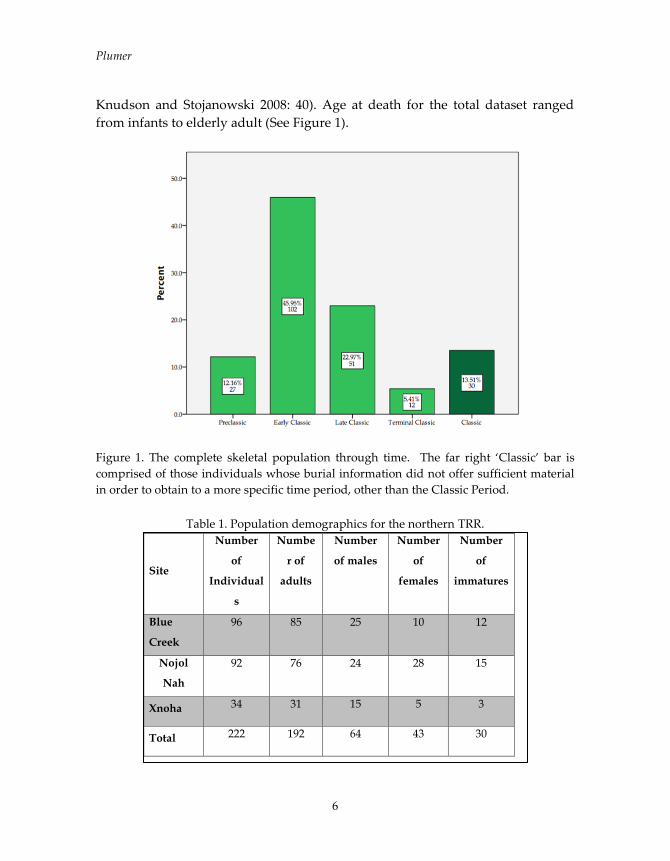
The northern TRR is a geographic region of approximately 1600 km2 located in
the Maya lowlands (Sullivan 2002: 197). The skeletal sample consists of 222
individuals, from three separate sites in the northern Three Rivers Region: Blue
Creek, Nojol Nah, and Xnoha. Occupation for this area in the northern TRR has
been dated through ceramic analysis and dates from the Middle Formative,
about 650BC, to the Terminal Classic, roughly 1000AD (Figure 1).
The osteological methods for skeletal features (age, sex) used throughout the
study followed approaches set by Bass (1984) and Buikstra and Ubelaker (1994).
In the case of linear enamel hypoplasia (LEH), this was recorded as slight,
moderate, or severe following methods suggested by Goodman and colleagues
(Goodman and Song 1999; Goodman et al. 1984), and Hillson (1979; 1996; 2005).
Trauma was observed in the form of healed fractures and was recorded by
notating the location on the bone, as well as the size and type of fracture.
Of the 222 individuals comprising the complete skeletal sample, 96 came from
Blue Creek, 92 from Nojol Nah, and 34 from Xnoha (Table 1). Of the total adult
dataset, 64 were determined to be male, 41 female, and 85 could not be assigned
a biological sex. There were 30 immatures among the three populations.
Subadults were not included in the assessment of biological sex, as methods for
sexing immatures is problematic (Buikstra and Ubelaker 1994: 16; Lewis 2007;
Plumer
6
Knudson and Stojanowski 2008: 40). Age at death for the total dataset ranged
from infants to elderly adult (See Figure 1).
Figure 1. The complete skeletal population through time. The far right ‘Classic’ bar is
comprised of those individuals whose burial information did not offer sufficient material
in order to obtain to a more specific time period, other than the Classic Period.
Table 1. Population demographics for the northern TRR.
Site
Number
of
Individual
s
Numbe
r of
adults
Number
of males
Number
of
females
Number
of
immatures
Blue
Creek
96 85 25 10 12
Nojol
Nah
92 76 24 28 15
Xnoha 34 31 15 5 3
Total 222 192 64 43 30

Health Indicators through Time
7
Figure 2. Age categories for the complete dataset.
RESULTS
Linear Enamel Hypoplasia in the northern Three Rivers Region
LEH are grooves or pits that form in the teeth as the result of disruption of the
growth of tooth enamel (Figure 3). LEH acts as an indicator of poor overall heath
in childhood as it has been associated with to insufficient diet and metabolic
stress (Hillson 1996). In total, 1083 individual teeth belonging to 130 individuals
could be examined of which LEH was observed on 68 (6.4%) teeth with one or
more teeth affected in 30 (30/130%) individuals.
Fishers Exact tests were run in order to establish whether there were any
differences in rates of LEH through time at the three sites in this study. Because
LEH is caused by the disruption of dental growth, it is very useful in
determining childhood health, even in adults. As there are no significant
differences in rates of dental hypoplasia throughout the three sites, it could
possibly indicate that therefore there were no large differences in the diet
through time at the sites (Table 1).
Plumer
8
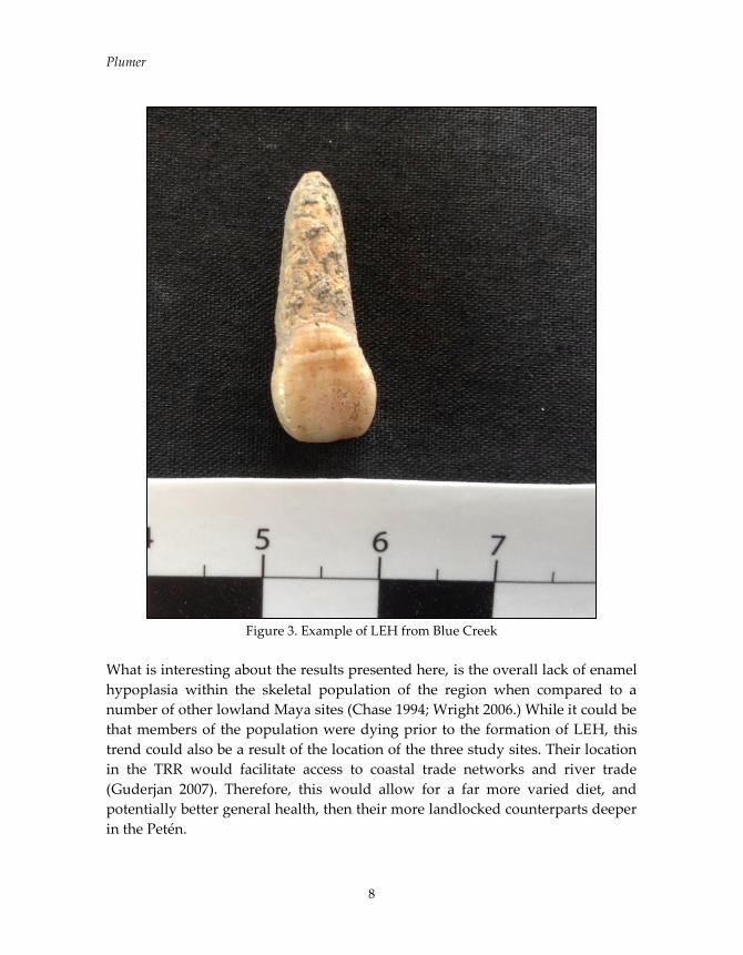
Figure 3. Example of LEH from Blue Creek
What is interesting about the results presented here, is the overall lack of enamel
hypoplasia within the skeletal population of the region when compared to a
number of other lowland Maya sites (Chase 1994; Wright 2006.) While it could be
that members of the population were dying prior to the formation of LEH, this
trend could also be a result of the location of the three study sites. Their location
in the TRR would facilitate access to coastal trade networks and river trade
(Guderjan 2007). Therefore, this would allow for a far more varied diet, and
potentially better general health, then their more landlocked counterparts deeper
in the Petén.

Health Indicators through Time
9
Table 2: LEH through time among the complete dataset.
Skeletal Trauma in the Three Rivers Region
A number of cases of skeletal trauma were observed among the skeletal remains
of individuals from the northern TRR. These were all bone fractures that were
well healed by the time of death. Fractures are the most common form of trauma
found in archaeological contexts (Waldron 2009). The fractures seen within this
assemblage recorded primarily in long bones, and the metatarsals, metacarpals,
and phalanges of the feet and hand.
A total of 167 (167/222) individuals could be evaluated for the presence of
fractures. Individuals eliminated from this sample were those represented only
Linear Enamel Hypoplasia
Total
None
Observed Slight Moderate Severe
Time
Period
Preclassic Count 2 0 0 0 2
Percent 100.0 0.0 0.0 0.0
Early
Classic
Count 422 21 19 0 462
Percent 91.3 4.5 4.1 0.0
Late
Classic
Count 449 6 6 3 464
Percent 96.8 1.3 1.3 0.6
Terminal
Classic
Count 15 2 1 0 18
Percent 83.3 11.1 5.6 0.0
Classic Count 127 3 7 0 137
Percent 92.7 2.2 5.1 0.0
Total Count 1015 32 33 3 1083
Percent 93.7 3.0 3.0 0.3

Plumer
10
by dentition, or were found to be too highly fragmentary for accurate recording.
Prevalence of fracture was similar among all three sites and there was no
significant difference between sites. 11.8% (N=6) of the skeletal population at
Blue Creek presented with fractures, 8.0% at Nojol Nah (N=7) and 17.2% at
Xnoha (N=5).
Table 3: Fractures through time for the complete dataset
Despite the small sample size, frequency tests were run for the entire dataset
through time, so that any patterns or anomalies might be discernible. However,
across time fracture rates were also continuous and continuity was held across
the categories (Table 3). All fractures were observed on adult remains, none were
found on juvenile remains. This result is standard for archaeological skeletal
Fractures
Total
None
Observed
Healed
Fracture Unknown
Time
Period
Preclassic Count 18 1 8 27
Percent 66.7 3.7 29.6
Early
Classic
Count 68 6 28 102
Percent 66.7 5.9 27.5
Late
Classic
Count 37 8 6 51
Percent 72.5 15.7 11.8
Terminal
Classic
Count 10 0 2 12
Percent 83.3 0.0 16.7
Classic Count 16 3 11 30
Percent 53.3 10.0 36.7
Total Count 149 18 55 222
Percent 67.1 8.1 24.8

Health Indicators through Time
11
remains, likely due to children living through into adulthood and therefore
would not be represented in juvenile remains (Waldron 2009: 150).
Pinhasi and Bourbou (2008) warn to be wary of mistaking post-mortem fractures
occurring during the taphonomic process as peri- or antemortem fractures.
However, in this skeletal collection this was not an issue as the remains were
most often so fragmentary that only healed fractures could diagnosed. Because of
the fragmentary nature of many remains in the Maya area, this is a typical
occurrence within Maya skeletal populations, and typically only healed fractures
are recorded in Maya skeletal assemblages (Wright 2006: 186) are typically
recorded. Of the Pasión Maya skeletal series, Wright (2006: 186) recorded that
trauma to the skeleton was ‘rare’ and that all the fractures noted were well
healed.
CONCLUSIONS
One of the overarching themes throughout this analysis is a great stability in
health through time in the region. The Three Rivers Region had a long
occupational period, and it is known that the region was inhabited from the
middle Preclassic through the Terminal Classic. While in the Late Classic in
many other areas of the Maya realm populations were dwindling, during the
Late Classic in northern Belize and particularly in the Three Rivers Region the
population was actually at its highest levels, due to a growth in agricultural
practices (Guderjan 2007; Sullivan 2002).
There have been a number of different large-scale events documented
archaeologically at the three sites, including a large shift in political power at the
site of Blue Creek during the end of the Early Classic period (Guderjan 2007)
Even with these different events, whatever they might have entailed, the
overarching theme here is that the Three Rivers Region as a whole was very
demographically and economically stable through time. Even while events
changed the political landscape around the Alacranes Bajo, overall health and
population growth continued to remain stable.

Plumer
12
REFERENCES CITED
Buikstra, Jane E., and Douglas H. Ubelaker (editors)
1994 Standards for Data Collection from Human Skeletal Remains:
Proceedings of a Seminar at the Field Museum of Natural History Organized
by Jonathan Haas. Arkansas Archaeological Survey Research Series No. 44.
Chase, Diane Z.
1994 Human. Osteology, Pathology, and Demography as: Represented in the
Burials of Caracol, Belize. In Studies in the Archaeology of Caracol, Belize,
edited by Diane Z. Chase and Arlen Chase, pp. 123-138. Pre-Columbian Art
Research Institute Monograph 7, San Francisco.
Goodman, Allen H., and Rhan-Ju Song
1999 Sources of Variation in Estimated ages at Formation of Linear Enamel
Hypoplasias. In Human Growth in the Past: Studies from Bones and Teeth, edited
by Robert D. Hoppa and Charles M. Fitzgerald, pp. 210-240. Cambrige
University Press.
Goodman, Alan H., Debra L Martin, George J. Armelagos and George Clark
1984 Indications of Stress from Bone and Teeth. I n Paleopathology at the Origins
of Agriculture, edited by Nathan Cohen and George J. Armelagos, pp. 13-49.
Academic Press, Inc. New York..
Guderjan, Thomas
2007 The Nature of an Ancient Maya City: Resources, Interaction, and Power at Blue
Creek, Belize. University of Alabama Press. Tuscaloosa, Alabama.
Hillson, Simon
1979 Diet and Dental Disease. World Archaeology, Vol. 11 No. 2, Food and
Nutrition, pp. 147-162.
1991 Dental Histology as an Index of Past Community Health. In Health in
Past Societies: Biocultural Interpretations of Human Skeletal Remains in
Archaeological Contexts, edited by Helen Bush and Marek Zvelebil pp. 53-66.
BAR International Series 567.
1996 Dental Anthropology. Cambridge University Press .
2005 Teeth. Cambridge Manuals in Archaeology. Cambridge University Press.

Health Indicators through Time
13
Knudson, Kelly J. and Christopher M. Stojanowski
2008 New Directions in Bioarchaeology: Recent Contributions to the Study of
Human Social Identities. Journal of Archaeological Research 16(4):397-432.
Lewis, Mary E.
2007. The Bioarchaeology of Children: Perspectives from Biological and Forensic
Anthropology. Cambridge Studies in Biological and Evolutionary
Anthropology, Vol. 50. Cambridge University Press.
Pinhasi, Ron, and Chryssi Bourbou
2008 How Representative Are Human Skeletal Assemblages for Population
Analysis? In Advances in Human Paleopathology, edited by Ron Pinhasi and
Simon Mays, pp 31-44. Wiley, West Sussex, England.
Serafin, Stanley, Carlos Peraza Lope, and Eunice Uc Gonzalez
2014 Bioarchaeological Investigation of Ancient Maya Violence and Warfare
in Inland Northwest Yucatan, Mexico. American Journal of Physical
Anthropology 154:140-151.
Sullivan, Lauren A.
2002 Dynamics of Regional Integration in Northwestern Belize. In Ancient
Maya Political Economies. Editors Marilyn A. Masson and David A. Freidel,
pp. 197-222. AltaMira Press, Walnut Creek, California.
Waldron, Tony
2009 Paleopathology. Cambridge University Press. New York, NY.
Wright, Lori E
2006 Diet, Health, and Status among the Pasión Maya: A Reappraisal of the Collapse.
Vanderbilt Institute of Mesoamerican Archaeology, Volume 2. Vanderbilt
University Press, Nashville, Tennessee.

15
CLIMATE CHANGE AND CHIEFDOM ECODYNAMICS IN THE
EASTERN ANDEAN CORDILLERA OF COLOMBIA
Michael P. Smyth, The Foundation for Americas Research, Inc.
Timothy Beach, University of Texas-Austin
Eric M. Weaver, National Park Service/Malpais and El Morro National
Monuments
INTRODUCTION
Climate change and environmental systems were key to complex societies in the
Eastern Colombian Andes. Researching both cultural and environmental
contexts can reveal the role of drought cycles, flooding events, and erosion in the
formation of Muisca chiefdoms--ranked societies based on kinship where social
groups have unequal access to status positions and prestige. There is now
compelling evidence to suggest that variable precipitation and even severe
erosion events impacted Muisca societies dependent on irrigation agriculture in
semi-arid valley of Leyva in the Department of Boyacá (Figure 1).
Archaeological research in the Cundiboyacense altiplano suggests that the
emergence of Muisca social-political hierarchy was related to acquiring prestige
and not wealth differences such as integrating regional populations, control of
fertile lands, or redistribution of critical resources. The role of environmental
factors, however, has not been given adequate research attention, even though
climate, water, and erosion were crucial to chiefdoms in the Andean Highlands
(Smyth 2014; Smyth et al. 2015).
Interdisciplinary investigation near the monolithic archaeological park of El
Infiernito, the Stonehenge of Colombia, is providing preliminary findings
regarding chiefdoms and environment. For example, "in situ" footing stones for a
stone-wall and oval-shaped structure suggest an elite building within a chiefly
compound dating between the 11th and 15th centuries AD. Soil survey and
penetrating cores along the Rio Leyva show evidence for major erosion episodes
while deep horizontal trenches in the Leyva floodplain discovered a possible
stream channel or irrigation canal. Exploration of La Cueva de la Fábrica
encountered active speleothems, the most promising stalagmites were extracted
for preliminary paleoclimate proxy reconstruction. Water samples were collected
for calibration with the surface climate.

Smyth et al.
16
Figure 1. Map of the Valley of Leyva, the archaeological park of El Infiernito, and the oval
(red) stone structure and associated monoliths investigated in 2015.
BACKGROUND
Located 120 km NE of Bogotá, the Leyva valley was populated with Muisca
chiefdoms along river floodplains surrounded by upland mountains between
El INFIERNITO
Stone Structure
Climate Change and Chiefdom Ecodynamics
17
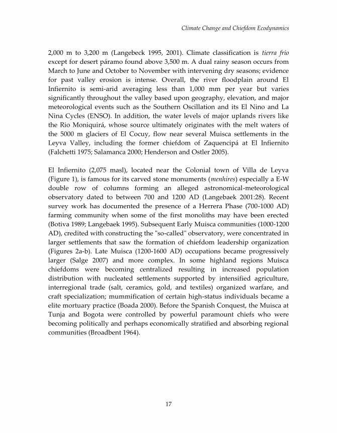
2,000 m to 3,200 m (Langebeck 1995, 2001). Climate classification is tierra frio
except for desert páramo found above 3,500 m. A dual rainy season occurs from
March to June and October to November with intervening dry seasons; evidence
for past valley erosion is intense. Overall, the river floodplain around El
Infiernito is semi-arid averaging less than 1,000 mm per year but varies
significantly throughout the valley based upon geography, elevation, and major
meteorological events such as the Southern Oscillation and its El Nino and La
Nina Cycles (ENSO). In addition, the water levels of major uplands rivers like
the Rio Moniquirá, whose source ultimately originates with the melt waters of
the 5000 m glaciers of El Cocuy, flow near several Muisca settlements in the
Leyva Valley, including the former chiefdom of Zaquencipá at El Infiernito
(Falchetti 1975; Salamanca 2000; Henderson and Ostler 2005).
El Infiernito (2,075 masl), located near the Colonial town of Villa de Leyva
(Figure 1), is famous for its carved stone monuments (menhires) especially a E-W
double row of columns forming an alleged astronomical-meteorological
observatory dated to between 700 and 1200 AD (Langebaek 2001:28). Recent
survey work has documented the presence of a Herrera Phase (700-1000 AD)
farming community when some of the first monoliths may have been erected
(Botiva 1989; Langebaek 1995). Subsequent Early Muisca communities (1000-1200
AD), credited with constructing the "so-called" observatory, were concentrated in
larger settlements that saw the formation of chiefdom leadership organization
(Figures 2a-b). Late Muisca (1200-1600 AD) occupations became progressively
larger (Salge 2007) and more complex. In some highland regions Muisca
chiefdoms were becoming centralized resulting in increased population
distribution with nucleated settlements supported by intensified agriculture,
interregional trade (salt, ceramics, gold, and textiles) organized warfare, and
craft specialization; mummification of certain high-status individuals became a
elite mortuary practice (Boada 2000). Before the Spanish Conquest, the Muisca at
Tunja and Bogota were controlled by powerful paramount chiefs who were
becoming politically and perhaps economically stratified and absorbing regional
communities (Broadbent 1964).

Smyth et al.
18
Figures 2a (left) and 2b (right). Photos looking N and S of the aligned columns and
upright monoliths of El Infiernito archaeological park.
Emerging complex society in the Leyva Valley is implied by El Infiernito
monuments including numerous spatially aligned carved stone columns (the
observatory) as well as dozens of phallus-like monoliths standing up to 4.5 m
tall. The latter surrounds a dolomite slab tomb which allegedly contained the
remains of high status individuals (Silva 1983). El Infiernito was clearly the
monumental center of a large town for a chiefdom by the 12th century AD if not
earlier. The astronomical and phallus cult interpretations of the various stone
monuments remain perplexing because so little is known about the surrounding
community.
RECENT RESEARCH
Archaeology
An enigmatic stone structure with tamped earthen floor and postholes for a
perishable roof was discovered near a concentration of carved stone monoliths
outside the archaeological park (Figure 3). Horizontal exposures located
numerous artifact concentrations associated with an earthen floor suggesting
offerings of abundant decorated ceramic sherds and deer fauna considered
material remains indicative of elite status among Colombian highland chiefdoms
(Boada 2007). Importantly, an in situ masonry wall 1 m thick and about 6 m long
was revealed adjacent to posthole features that together strongly support
identification of a chiefly building. In addition, floor impressions suggest that
there were stone monoliths (phallus stones and others) that once stood in front of
the wall. Though the wall is straight, the corners of the building are curved or
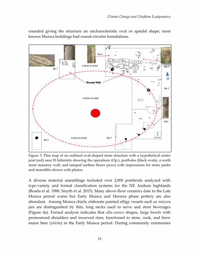
Climate Change and Chiefdom Ecodynamics
19
rounded giving the structure an uncharacteristic oval or apsidal shape; most
known Muisca buildings had round-circular foundations.
Figure 3. Plan map of an outlined oval-shaped stone structure with a hypothetical center
post (red) near El Infiernito showing the operations (Op.), postholes (black ovals), a north
stone masonry wall, and tamped earthen floors (pisos) with impressions for stone jambs
and monoliths shown with photos.
A diverse material assemblage included over 2,000 potsherds analyzed with
type-variety and formal classification systems for the NE Andean highlands
(Boada et al. 1988; Smyth et al. 2015). Many above-floor ceramics date to the Late
Muisca period wares but Early Muisca and Herrera phase pottery are also
abundant. Among Muisca chiefs, elaborate painted effigy vessels such as múcura
jars are distinguished by thin, long necks used to serve and store beverages
(Figure 4a). Formal analysis indicates that olla-cuenco shapes, large bowls with
pronounced shoulders and incurved rims, functioned to store, cook, and brew
maize beer (chicha) in the Early Muisca period. During community ceremonies

Smyth et al.
20
concerning agricultural fertility or times of drought, chiefs provided maize beer
to their constituents. Preliminary ceramic analysis shows a sharp rise in the ratio
of bowls to jars from the Early to Late Muisca periods suggesting that the storage
and serving of liquids changes dramatically and reflect increased beer
production and consumption, and/or the need for greater storage of potable
water during prolonged dry periods.
Figures 4a (left), 4b (middle), and 4c (right). (a) Múcura vessel on display at the Gold
Museum in Bogotá. (b) Cached effigy offering found outside the stone structure showing
a Muisca female deity figure and (c) three blackstone spindle whorls with fine white line
incised decoration (above) found on-floor within the stone structure.
Caches of decorated potsherds as well as deer and bird fauna appear to be
dedicatory offerings associated with a chiefly residence or elite temple. One
particular cached offering found just outside the masonry wall contained a
ceramic effigy from a múcura vessel symbolizing a Muisca female deity figure
(Figure 4b) that likely embodies matriarchal structures of Muisca society.
Blackstone spindle whorls with fine incised white-line decoration were found on-
floor within the stone structure indicating that cloth production (mostly cotton)
took place at this extended chiefly household (Figure 4c). In Muisca society cloth
production was a major female economic activity especially within polygamous
chiefly families, and was a primary source of elite wealth for status display and
as commodities for gifting and exchange.
Our survey focuses on Prehispanic settlement patterns and hydraulic features
around El Infiernito (Fajardo 2012; Salge 2007; Henderson and Ostler 2005;
Langebaek 2001) to locate natural features related to major erosion events (such
as significant droughts in conjunction with major flooding episodes) in times of
rapid climate change. Some 800 m NE along the Loma Carrera, a natural
perennial spring (Cañada las Peñas) situated above a carboniferous shale deposit

Climate Change and Chiefdom Ecodynamics
21
produces hydrostatic surface water that empties into the Rio Leyva. Near the
spring are two seemingly anthropogenic ovoid pools reminiscent of the
ceremonial baths or "lavapatas" at the Alta Magdalena site of San Agustin
(Duque Gomez 1964; Drennan 1995). Adjacent terraces show surface artifacts
indicating settlement occupation. But within a lower seasonal drainage, a double
alignment of megalithic boulders represent some form of a hydraulic feature
similar to check damns or holding reservoirs used for down slope irrigation
agriculture. A stone structure with huge megalithic boulders and shaped flag
stones is orientated some15 km E towards the mountaintop (páramo) location of
Laguna de Iguaque, the legendary origin place of the Muisca people. Deep
trenching near the confluence of the Cañada las Peñas and the Rio Leyva
revealed a buried stream channel and/or possible irrigation canal, Prehispanic
and Colonial ceramics, and deep alluvial deposits from major erosion episodes
(below). Because many areas along the Rio Leyva were altered by erosion and
flooding events, El Infiernito settlement may have been more densely occupied
and/or larger in area than the current estimate of 6.75 ha for the site center and a
1 km² hinterland during the Late Muisca period (Langebaek 2001, 2013).
Reconnaissance is also focused on other settlement features related to climate
change and erosion events at El Infiernito and vicinity. Our survey has begun to
locate water management features to determine adaptations to water shortages
and flooding events to identify severe erosion during periods of rapid climate
change such as the ENSO Cycles. For example, Colombia is experiencing a strong
El Nino cycle when almost no rainfall has fallen in the Leyva Valley in 2015.
Under such valley drought conditions, heavy rainfall at high altitudes at the
nearby Iguaque mountains and up river outside the valley proper can produce
flash flooding causing catastrophic damage to agriculture and settlement. A
major past flooding event was revealed by trenching of the Rio Leyva floodplain
in 2015 where a 175 cm stratum of immature topsoil was buried showing no soil
development (below). In response to drought and flooding, documentary
evidence suggest that the Muisca built raised fields along the Leyva Valley
floodplains (Mora Pacheco 2011) like those documented along the Rio Bogotá
near the town of Funzá (Kruschek 2003) and elsewhere on the Sabana de Bogotá
(Broadbent 1968; Boada 2006). Such research will be pursued by future
settlement and soil surveys.
Soil and Sediment
Smyth et al.
22
Soil research around Villa de Leyva studied environmental episodes related to
drought, erosion and sedimentation, and flooding to assess their role in the
formation of highland Colombian chiefdoms. This work allowed acquaintance
with regional ecosystems and geomorphology and determination of potential
sites for studying proxies for climate change.
To research these topics across time requires depositional sites in lakes, river
floodplains, and stalagmites from caves. For lake environments, we found only a
marginal location but removed a 2 m pollen core from a shallow lake at a high
altitude setting (~3,500 m) known locally as El Toro Bravo. It is expected that
possible pollen, dating, geochemical, and micropaleontology will hold evidence
of ecological or climate shifts. We observed that this landscape was dramatically
eroded, which local publications call a "desert," despite local annual precipitation
totals (~1000 mm) that are far above a climatically-induced desert. Some
literature refers to erosion and dating erosion in this region (Mora Pacheco 2012),
and research on stream sediment yields show modern erosion is extremely high
in the Colombian Andes (Latrubesse and Restrepo 2014).
Identification began on erosion and map erosion surfaces in the region based on
gully patterns, soil pedestals (hoodoos), exposed lower soil horizons, and
exposures (Figure 5). We also observed that local floodplains appeared to be
highly aggraded with flat and wide surfaces likely from heavy flooding and
aggradation draping over the typical microtopography of floodplain from lateral
planation processes. We hypothesize that accelerated erosion was and probably
still is creating large amounts of stream load choking channels and creating
overbank flooding and sedimentation of valleys. To test this hypothesis, our
team probed floodplains with a soil coring device and studied soils and sediment
stratigraphy in two backhoe trenches. These trenches revealed a buried stream
channel and a topsoil buried by 175 cm across a broad expanse of one of the
floodplains (Figure 6). The sediment burying the paleosol was immature
showing no soil development, indicating rapid deposition and little time of
exposure at a surface that would begin to melanize and form a bio-mantle
topsoil. In contrast, the buried soil was well developed, indicating a topsoil
formation at a surface long enough to form a 55 cm thick A horizon (now an Ab
horizon). Soil and sediment samples for analyses are awaiting transport to the
U.S. that could indicate the timing of deposition, the geochemistry of sediments,
and evidence for rates of sedimentation.

Climate Change and Chiefdom Ecodynamics
23
Figure 5. Eroded landscape in the Valle de Leyva with (A) Hoodoo formation and (B)
erosion to bedrock.
Figure 6. Upright post buried by 175 cm of deposition with sediment and no evidence of
soil development.

Smyth et al.
24
Based on mapping and the timing and geochemistry of sedimentation across
enough sites, we will investigate the drivers of landscape change. Three
hypotheses about erosion-induced instability either alone or combined are
suggested: (1) ecological change like bark beetle outbreaks; (2) human-induced
land use change (deforestation) either in antiquity during the Herrera, Early
Muisca, and Late Muisca periods, and Colonial changes from livestock
introductions and mining, or modern deforestation and overgrazing; and (3)
climatic change from the Medieval Climate Anomaly, Little Ice Age, ENSO
Cycles, and modern global warming.
To test these land use ecological change hypotheses we will date the
sedimentation rates, stable and unstable soil surfaces, pollen evidence,
geochemistry and biochemistry of sediments that could correlate sediments with
the timing of other events through AMS (Accelerator Mass Spectrometer), 210Pb
(U/Th series disequilibrium method), and OSL (optically stimulated
luminescence) dating. This work will begin to develop a climate record from the
lake record in its pollen and other microfossil records from follow-up coring at
the highland wetlands location of El Toro Bravo in the valley of Leyva and from
La Cueva de la Fábrica that yielded potential speleothems that might produce a
paleoclimate record (Beach 2015; Wells et al. 2015).
Cave Research
Mountain caves near El Infiernito were explored and assessed for viable
speleothem specimens for paleoclimate study. La Fábrica, a stream cave east of
Santa Sofia, held the most promise and exhibits a relatively steep incline and
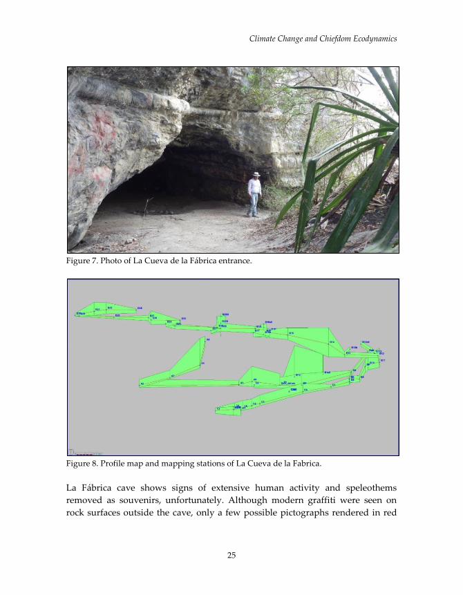
multiple entrances (Figures 7-8). The cave was surveyed for a total length of 606
m (1,990 ft) and at an average inclination of 6.6 º drops 25 m (82 ft) before the
stream reaches a sumped area. Comprised of two primary passages with a total
of five entrances, the large, dry upper passage terminates relatively quickly in
breakdown. Most of the length of the cave, where all the formations were
obtained, is in the lower passage that contains an active stream. A sketch map
was created that detailed plan, profile, and cross-sections.
Climate Change and Chiefdom Ecodynamics
25
Figure 7. Photo of La Cueva de la Fábrica entrance.
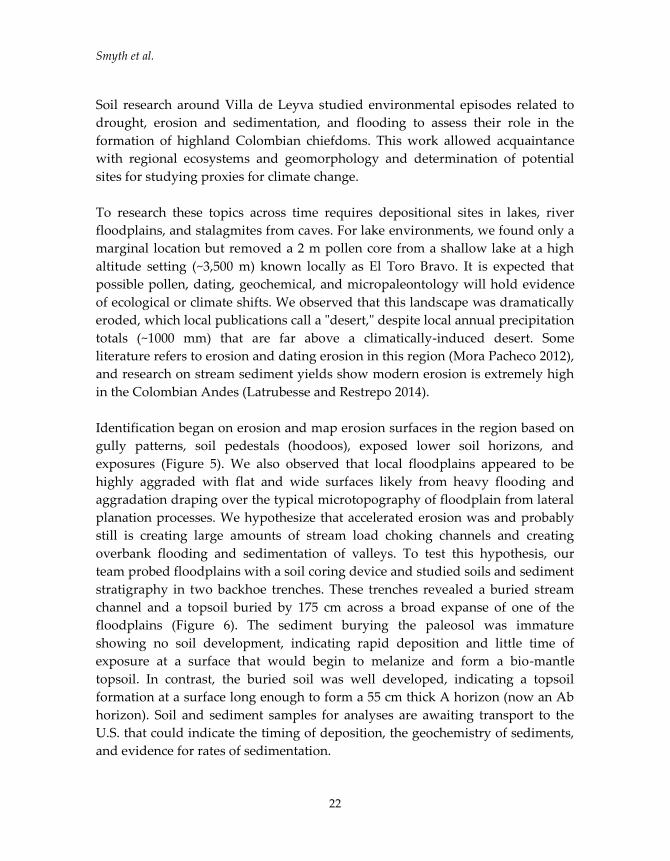
Figure 8. Profile map and mapping stations of La Cueva de la Fabrica.
La Fábrica cave shows signs of extensive human activity and speleothems
removed as souvenirs, unfortunately. Although modern graffiti were seen on
rock surfaces outside the cave, only a few possible pictographs rendered in red

Smyth et al.
26
pigment were observed, and there is no clear evidence of ancient Muisca activity
within the cave. However, four stalagmites were located and collected at the
extreme frontiers of the cave, though only one presented definite signs of current
formation activity. The first speleothem was collected at station B20a1 (Figure 9)
found in an area of the upper cave passage relatively close to the surface. Two
other speleothems were taken at stations C2a and C2a1: the first was relatively
small but appeared to be active based on the presence of a white cap, while the
other was less than .5 m from the one at station C2a and did not appear active
but was much better developed. In the removal process a nearby stalagmite was
also taken that may have some connection with the speleothem’s development;
both are located within a water channel heavily-decorated with soda straws. The
same area has a significant gypsum crust under the ledge.
Figure 9. Speleothem 1 from Station B20a1.
The lower stream passage shows little gypsum crust and none at the beginnings
of a steep incline where flowstone becomes prevalent with small travertine dams
and waterfalls. The lower sections of the cave are relatively bare of secondary
deposits and suggest more recent flooding (e.g., vegetation on ceiling). On a
higher ledge, the fourth speleothem was found at Station C8a and was the “best”
developed but does not appear to be currently active. A total of 11 "drip" water
samples were collected near stations where speleothems were recovered.
Climate Change and Chiefdom Ecodynamics
27
CONCLUSIONS
This research seeks to obtain contextual information on settlement patterns and
resource management related to changes in status architecture, house structures,
ceramics, trade goods, and craft specialization that may represent socioeconomic
responses to societal stresses associated with water dynamics and major
landscape transformations. We propose that rapid climate change played a role
in the centralization of ranked societies in the Leyva valley. Studying the full-
range of human responses to environmental factors reveals profound insights
into diachronic culture change. Did wealth differences (the integration of
regional populations, the control of fertile lands, and the redistribution of critical
resources), become increasingly significant during periods of major climate
change? This idea is contrary to current arguments for Muisca archaeology
which suggest that centralization was acquired via prestige. A case in point is the
Little Ice Age of the 14th to 16th centuries which was certainly much drier and
cooler than previous times and must have impacted centralized chiefly
leadership among the Muisca, who by the 16th century were among the most
populated culture groups in the Americas.
Understanding the full-range of human adaptations under climatic stress and the
environmental conditions that promote or retard development among
intermediate-level societies are significant research issues that remain
unexplored in the archaeology of the Eastern Andean highlands. New data about
Muisca chiefdoms that no longer exist in Colombia can provide valuable
comparable insights to other New World complex societies regarding the far-
reaching and multipartite effects of climate change and environmental systems
(e.g., Dunning et al. 2013, 2014; Smyth et al. 2011, 2012, 2014, 2017, in press b).
Clearly, the ecodynamics of highland chiefdoms represents an important new
area of inquiry for archaeology and allied disciplines.
ACKNOWLEDGMENTS
This research was funded by a grant from the National Geographic-Waitt
Foundation (W352-14) and contributions from the Foundation for Americas
Research, Inc. and the University of Texas at Austin. We would like to thank the
Awazako Family for their kindness and assistance in beginning this preliminary
project. Luisa Aebersold, Greta Wells, Beth Cortwright, Nikki Woodward, Pedro
Luis Suarez, Pilar Suarez Smyth, and Martha Esperanza Suarez performed
valuable services and shared their expertise that we greatly appreciate.
Smyth et al.
28
REFERENCED CITED
Beach, Timothy
2015 Keynote on Soil and Sediment Transfers in Middle America at the
PAGES working group on Global Soil and Sediment Transfers in the
Anthropocene (GloSS) at the Department of Geography, University of Bonn,
Germany on 19th – 21st Aug. 2015.
Boada Rivas, Ana María
2000 Variabilidad Mortuoria y Organización Social Muisca en La Sabana de
Bogotá." En Sociedades complejas de la sabana de Bogotá, siglos VII al XVI d. C.,
editado por B. Enciso y M. Therrien. ICANH, Bogotá.
2006 Patrones de Asentamiento Regional y Sistemas de Agricultura Intensiva
en Cota y Suba, Sabana de Bogotá, (Colombia), FIAN, Banco de la Republica,
Bogotá.
2007 The Evolution of Social Hierarchy in a Muisca Chiefdom of the Northern Andes
of Colombia. University of Pittsburgh Memoirs in Latin American
Archaeology No. 17.
Boada Rivas, Ana María, S. Mora, and M. Therrien
1988 La arqueología: Cultivo de Fragmentos Cerámicos (Debate sobre la
Clasificación Cerámica en el Altiplano Cundiboyacense). Revista de
Antropología 4(2):161-200. Universidad de los Andes, Santa Fé de Bogotá.
Botiva, Alvaro
1989 La Altiplanicie Cundiboyacense. En Colombia Prehispánica--Regiones
Arqueológicas, pp. 77-116. Instituto Colombiano de Antropología, Santa Fé de
Bogotá.
Broadbent, Sylvia
1964 Los Chibchas. Organización Socio-Politico. Universidad Nacional de
Colombia, Bogotá.
1968 A Prehistoric Field System in Chicha Territory, Colombia. Ñawpa Pacha
6:135-154. Berkeley.
Drennan, Robert
1995 Mortuary Practices in the Alto Magdalena: the Social Content of the San
Augustin Culture. In Tombs for the Living: Andean Mortuary Practices, edited

Climate Change and Chiefdom Ecodynamics
29
by Timothy Dillehay, pp. 79-110. Dumbarton Oaks Research Library and
Collection, Washington, D.C.
Dunning, Nicholas P., Timothy Beach, L. Grasiozo Sierra, others, and M.P. Smyth
2013 A Tale of Two Collapses: Environmental Variability and Cultural
Disruption in the Maya Lowlands. Diálogo Andino 41:171-183.
Dunning, Nicholas P., Eric Weaver, Michael P. Smyth, and David Ortegón
Zapata
2014 Xcoch: Home of Ancient Maya Rain Gods and Water Managers. In The
Archaeology of Yucatan: New Directions and Data, edited by Travis W. Stanton,
pp. 65-80. BAR International Series, Oxford.
Duque Gómez, Luis
1964 Exploraciones Arqueológicas en San Augustin. Revista Colombiano de
Antropología, Suplemento No. 1, Instituto Colombiano de Antropología,
Imprenta Nacional, Bogotá.
Falchetti, Ana Maria
1975 Arqueología de Sutamarchán. Biblioteca Banco Popular, Bogotá. Fajardo
Bernal, Sebastian.
2011 "Jerarquía social de una comunidad en el valle de Leiva: unidades
domésticas y agencia entre los siglos XI y XVII." Informes Arqueológicos del
Instituto Colombiano de Antropología e Historia Número 6.
Henderson, Hope, and Nicholas Ostler
2005 Muisca Settlement Organization and Chiefly Authority at Suta, Valle de
Leyva, Colombia: A Critical Appraisal of Native Concepts of House for
Studies of Complex Societies. Journal of Anthropological Archeology 24(2):148-
178.
Kruschek, Michael
2003 The Evolution of the Bogota Chiefdom: A Household View. University of
Pittsburgh.

Smyth et al.
30
Latrubesse, Edgardo M., and Juan D. Restrepo
2014 Sediment Yield along the Andes: Continental Budget, Regional
Variations and Comparisons with other Basins from Orogenic Mountain
Belts. Geomorphology 216:225‐233.
Langebaek, Carl H.
2001 Arqueología regional en el Valle de Leiva: Procesos de ocupación humana en una
región de los Andes Orientales de Colombia. Colección Informes Antropológicos,
Instituto Colombiano de Antropología e Historia, Bogotá.
2013 Words, Things, and Text: El Infiernito, Archaeology, Documents and
Ethnology in the Study of Muisca Society. In Against Typological Tyranny in
Archaeology: A South American Perspective, edited by Cristóbal Gnecco and
Carl Langebaek, pp. 201-230. Springer.
Mora Pacheco, K. G.
2011 Prácticas Agrícolas Coloniales y Degradación del Suelo: El Caso de
Saquencipá. Revista Geográfica de América Central, Numero Especial EGAL
pp. 1-14.
2012 Livestock Farming in the Saquencipá Valley, New Kingdom of Granada,
Colombia in the 16th and 17th Centuries. Pastos 42(2):251-272
Salamanca, María Fernanda
2000 "Asentamientos tempranos en el valle de Sáchica, Boyacá." Tesis de grado.
Universidad de los Andes. Bogotá.
Salge Ferro, Manuel
2007 Festejos Muiscas en el Infiernito, Valle de Leyva: La consolidación del Poder
Social. Universidad de los Andes, Bogotá.
Silva, Eliécer
1983 Descubrimientos arqueológicos en Villa de Leiva. Comunicación
científica preliminar. En Memorias II Congreso de Antropología en Colombia.
Tomo 1:235-250. Universidad de Antioquia. Medellin.
Climate Change and Chiefdom Ecodynamics
31
Smyth, Michael P.
2014 "Cambios Climáticos, Glaciares de Alta Altitud, y Ecodinámicos
Humanos entre los Cacicazgos Colombianos de los Andes Orientales."
Ponencia para la Segunda Conferencia Intercontinental de la SAA en Lima, Perú.
Smyth Michael P., Ezra B.W. Zubrow, David Ortegón Zapata, Nicholas P.
Dunning, and Philip van Beynen
2011 Paleoclimatic Reconstruction and Archaeological Investigations at Xcoch
and the Puuc Region of Yucatan, Mexico: Exploratory Research into Arctic
Climate Change and Maya. Culture Processes. Report to the National Science
Foundation.
http://www.farinco.org/Publications/NSF_Report_2011_2012.pdf.
Smyth, Michael P., David Ortegón Zapata, Nicholas P. Dunning, and Eric M.
Weaver
2014 Settlement Dynamics, Climate Change, and Human Response at Xcoch
in the Puuc Region of Yucatan, Mexico. In The Archaeology of Yucatán: New
Directions and Data. In The Archaeology of Yucatan: New Directions and Data,
edited by Travis W. Stanton, pp. 45-64. BAR International Series, Oxford.
Smyth Michael P., David Ortegón Zapata, Nicholas P. Dunning, and Philip van
Beynen
2017 An Enigmatic Maya Center: Climate Change, Settlement Systems, and
Water Adaptations at Xcoch, Puuc Region, Yucatan. In Recent Investigations in
the Puuc Region of Yucatan, Mexico, edited by Mehgan Rubenstein, pp. 3-24.
Pre-Columbian Archaeology 8, Archaeopress Archaeology, Oxford.
Smyth Michael P., David Ortegón Zapata, Nicholas P. Dunning, and Philip van
Beynen
In press The Perfect Storm: Climate Change and Ancient Maya Response in the
Puuc Hills Region of Yucatan. Antiquity.
Wells, G., L. Aebersold, T. Beach, and M. Smyth
2015 Preliminary soil erosion and sediment budgets in the Valley of Leyva, Boyacá,
Colombia. Poster paper in preparation for the Geological Society of America
Annual Meeting in Baltimore, MD.


33
THE BLUE CREEK REJOLLADA REVISITED: TRANSITIONAL
IMPRINTS ON SEDIMENTOLOGICAL RECORDS
Luisa Aebersold, The University of Texas at Austin
Timothy P. Beach, The University of Texas at Austin
Sheryl Luzzadder-Beach, The University of Texas at Austin
Thomas Guderjan, University of Texas at Tyler
Fred Valdez, The University of Texas at Austin
INTRODUCTION
Dialogue concerning cumulative impacts of intense human-environment
interactions has created a newly proposed geological epoch known as the
Anthropocene. This epoch begins in the Holocene during a time of increased
atmospheric CO2 (carbon dioxide) and CH4 (methane gas) values, warmer
temperatures, massive deforestation events, and controlled fire use (Braje 2015;
Foley et al. 2013; Ruddiman 2013; Kaplan et al. 2011). Adaptations of increased
sedentary lifestyles and active transformations of the landscape occur alongside
a global trend of intensive agriculture, which reshape the earth’s environmental
systems. This paper is a preliminary case study in the determination of the
magnitude and timing of impacts concerning early human-environmental
interactions during the early stages of the Anthropocene. Specifically,
geoarchaeological evidence concerning the transition of subsistence strategies
from nomadic hunter-gatherer into more intense agricultural subsistence
strategies in the Maya Lowlands during the Archaic (8000 to 4000 B.P.) to the
Preclassic Period (4000 B.P. to 2000 B.P.) (Lohse 2010; Rosenswig et al. 2014).
Intense forest and wetland destruction represent the first significant contribution
to increasing greenhouse emissions. Considering archaeological data, as much as
three-fourths of the earth’s cumulative deforestation occurs prior to the
Industrial Revolution (Ruddiman 2013; Kaplan et al. 2011). Kaplan et al. (2011)
incorporates data from climate studies, soil, and CO2 from ice cores to produce a
model that reflects carbon emissions as a result of anthropogenic land cover over
time. This model produces a strong supporting case for anthropogenic forest
clearance and its causal effects on atmospheric emissions and supports the
scenario that people in the Neotropics were making immense modifications to
their landscape before the last three thousand years.

Aebersold et al.
34
This transformative behavior is visible by the imprint humans have left on
sediment sequences that can be described by the concept of soil memory
(Targulian and Goryachkin 2004). Soil memory is the ability of soil systems to
record environmental phenomena through formation processes occurring in situ,
as well as the soil record itself, reflecting environmental processes and changes.
The term legacy sediment is similar to soil memory, but refers to sediment produced
by major anthropogenic disturbance events such as deforestation, agriculture,
mining, and other human-induced environmental changes (James 2013). These
foundational concepts are useful in understanding human-environment
dynamics in order to interpret early anthropogenic effects on a landscape.
Anthropogenic sedimentological imprints are visible in the Maya Lowlands
region during the Early Preclassic or possibly earlier during the Archaic Period
(Beach et al. 2006). Massive deforestation and intensified land-use creates
erosional episodes in the form of legacy sediment along karst depressions in the
Maya Lowlands. These layers, also known as “Maya Clays,” are typically
associated with artifacts in the archaeological record (Beach et al. 2006). Massive
erosion rates during the Maya Preclassic and Classic periods deposited sediment
that buried the pre-Maya paleosols known as Eklu’um or “dark earth.” This
paleosol is common in many depositional environments of the central and
southern Maya Lowlands (Beach et al. 2006; Dunning and Beach 2004; Solís-
Castillo et al. 2013). Solís-Castillo et al. (2013) suggest the warmer and wetter
environment during the Archaic Period supports the soil’s chemical and physical
characteristics as markers for formation during an increased seasonality favoring
agriculture (Solís-Castillo et al. 2013). In fact, the most accelerated soil erosion
episodes correlate to three time periods including the Preclassic, the Late Classic,
and over the last few decades (Beach et al. 2006; Anselmetti et al. 2007).
These erosional episodes are closely correlated with intensified landscape
transformation due to domestication of various plants. Domestication refers to
genetic modification and physiological transformation of plant or animal species
which would requires human intervention to exist (Zeder et al. 2006). Cultigens
in the Mesoamerican Archaic Period first appeared as edible weeds that grow in
disturbed soils or midden piles around human settlements (Rice 2007). Major
cultigens of this remarkable era include corn, beans, squash, cacao, chili peppers,
cotton, agave, avocado, plums, and cherries (Jones 1994; Kennett and Beach 2013;
Piperno and Pearsall 1998; Pohl et al. 1996; Smith 2011; Zizumbo-Villarreal 2012).

The Blue Creek Rejollada Revisited
35
However, studying this critical time period in the Neotropics is difficult due to
the transient nature of sites, rising sea levels along coastlines, no monumental
architecture, and the clearing or destruction of Archaic ground surfaces to make
way for Maya architecture (Alcala-Herrera et al. 1994; Lohse 2009; Pohl et al.
1996).
BACKGROUND AND RESEARCH OBJECTIVES
To understand geological and anthropogenic soil erosion in Northwestern Belize
we studied sedimentation in a collapsed upland doline, called a rejollada (Munro-
Stasiuk 2014; Aebersold et al. 2015; Krause et al. Under Review). The rejollada’s
location on the Rio Bravo escarpment, which divides the Coastal Belize Zone and
the Eastern Peten Zone, provides an ideal site for studying upland wetland
manipulation by early inhabitants (Guderjan 2004). The rejollada has an elevation
of 119 to 124 masl and is located 200 m downslope from the ancient Maya site of
Blue Creek, Belize as shown in Figure 1. The archaeological site of Blue Creek
had a known occupation as early as the Middle Preclassic through the Late
Classic, about 2860 BP to 1100 BP (Guderjan 2004).
Massive erosion rates during the Maya Preclassc and Classic periods deposited
sediment that buried the pre-Maya paleosol, Eklu’um, which is also associated
with disturbance taxa pollen such as grasses and weeds. Researchers suggest an
increase in soil erosion during the Preclassic period (or earlier) and a decline
during the Classic period as a possible product of a change in cultural practices
that may have included soil conservation methods (Anselmetti et al. 2007; Beach
et al. 2015; Anderson and Wahl 2016). In the Blue Creek area, reduced sediment
budgets and increased limestone bedrock exposure lead to accelerated
infiltration and gullying (Beach 2006, Beach 2008). Our goal is to present a more
complete chronology of the site’s human activities by dating when sedimentation
and soil erosion occurred and make connections to ancient landscape
transformation during the Archaic and Preclassic periods.
The 2015 field season was a continuation of excavation efforts from 2003
involving investigations of human-environment interactions in the early
occupation periods of the Blue Creek area (Aebersold et al. 2015; Krause et al.
Under Review). The 2003 excavations reached a depth of 4 meters and a series of
paleosols, including one between 3.5 and 2.9 m associated with stone tools. AMS
dates for these paleosols dated to the Late Archaic period and early Preclassic

Aebersold et al.
36
Figure 1. General map of the Maya Research Program study area and the Blue Creek
rejollada.
The Blue Creek Rejollada Revisited
37
period, from 3940 to 4140 BP (Beach et al. 2006; Beach et al. 2008). This layer
predates all other artifact evidence in this area. During 2015 field season, we
expanded upon the 2003 findings in order to answer general questions: 1) How
are artifacts associated with paleosols and erosional episodes? 2) When do we
first see evidence of the Anthropocene in the Blue Creek area? 3) What significant
sedimentological markers do Archaic populations produce in the rejollada?
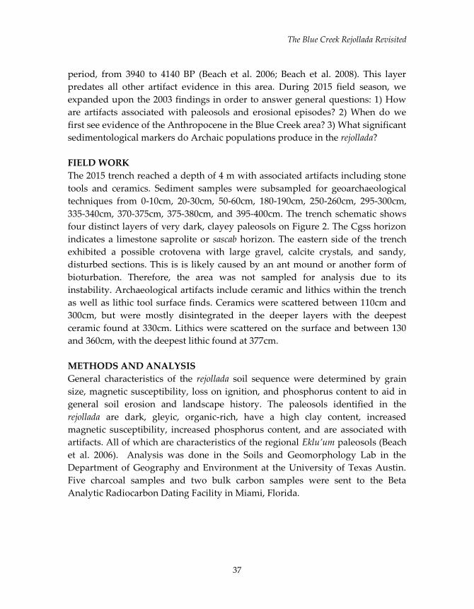
FIELD WORK
The 2015 trench reached a depth of 4 m with associated artifacts including stone
tools and ceramics. Sediment samples were subsampled for geoarchaeological
techniques from 0-10cm, 20-30cm, 50-60cm, 180-190cm, 250-260cm, 295-300cm,
335-340cm, 370-375cm, 375-380cm, and 395-400cm. The trench schematic shows
four distinct layers of very dark, clayey paleosols on Figure 2. The Cgss horizon
indicates a limestone saprolite or sascab horizon. The eastern side of the trench
exhibited a possible crotovena with large gravel, calcite crystals, and sandy,
disturbed sections. This is is likely caused by an ant mound or another form of
bioturbation. Therefore, the area was not sampled for analysis due to its
instability. Archaeological artifacts include ceramic and lithics within the trench
as well as lithic tool surface finds. Ceramics were scattered between 110cm and
300cm, but were mostly disintegrated in the deeper layers with the deepest
ceramic found at 330cm. Lithics were scattered on the surface and between 130
and 360cm, with the deepest lithic found at 377cm.
METHODS AND ANALYSIS
General characteristics of the rejollada soil sequence were determined by grain
size, magnetic susceptibility, loss on ignition, and phosphorus content to aid in
general soil erosion and landscape history. The paleosols identified in the
rejollada are dark, gleyic, organic-rich, have a high clay content, increased
magnetic susceptibility, increased phosphorus content, and are associated with
artifacts. All of which are characteristics of the regional Eklu’um paleosols (Beach
et al. 2006). Analysis was done in the Soils and Geomorphology Lab in the
Department of Geography and Environment at the University of Texas Austin.
Five charcoal samples and two bulk carbon samples were sent to the Beta
Analytic Radiocarbon Dating Facility in Miami, Florida.
Aebersold et al.
38
Figure 2. Profile of soil sequence from the BC2015-01 trench geoarchaeological
excavations.
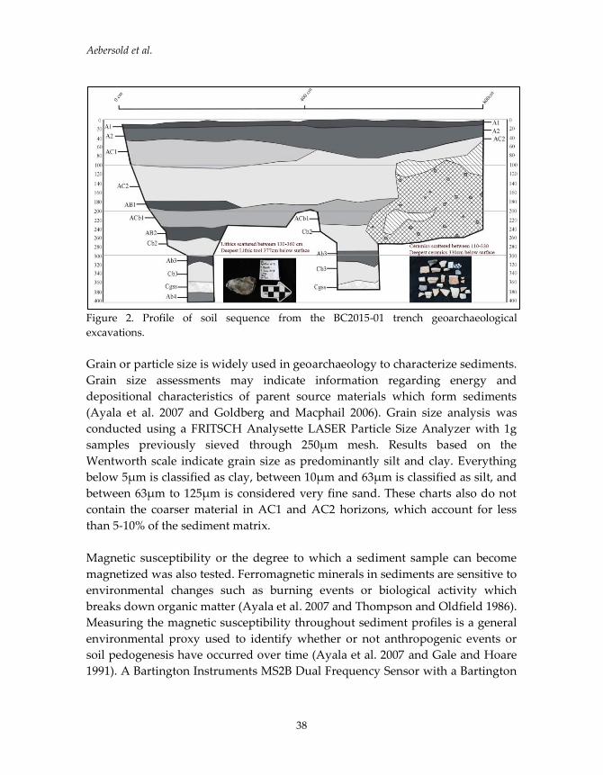
Grain or particle size is widely used in geoarchaeology to characterize sediments.
Grain size assessments may indicate information regarding energy and
depositional characteristics of parent source materials which form sediments
(Ayala et al. 2007 and Goldberg and Macphail 2006). Grain size analysis was
conducted using a FRITSCH Analysette LASER Particle Size Analyzer with 1g
samples previously sieved through 250µm mesh. Results based on the
Wentworth scale indicate grain size as predominantly silt and clay. Everything
below 5µm is classified as clay, between 10µm and 63µm is classified as silt, and
between 63µm to 125µm is considered very fine sand. These charts also do not
contain the coarser material in AC1 and AC2 horizons, which account for less
than 5-10% of the sediment matrix.
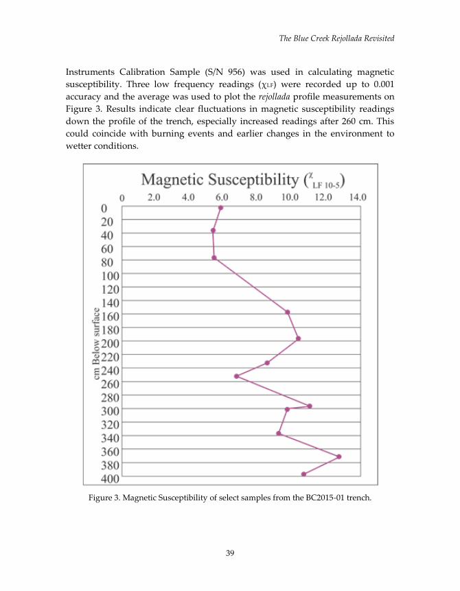
Magnetic susceptibility or the degree to which a sediment sample can become
magnetized was also tested. Ferromagnetic minerals in sediments are sensitive to
environmental changes such as burning events or biological activity which
breaks down organic matter (Ayala et al. 2007 and Thompson and Oldfield 1986).
Measuring the magnetic susceptibility throughout sediment profiles is a general
environmental proxy used to identify whether or not anthropogenic events or
soil pedogenesis have occurred over time (Ayala et al. 2007 and Gale and Hoare
1991). A Bartington Instruments MS2B Dual Frequency Sensor with a Bartington
The Blue Creek Rejollada Revisited
39
Instruments Calibration Sample (S/N 956) was used in calculating magnetic
susceptibility. Three low frequency readings (χLF) were recorded up to 0.001
accuracy and the average was used to plot the rejollada profile measurements on
Figure 3. Results indicate clear fluctuations in magnetic susceptibility readings
down the profile of the trench, especially increased readings after 260 cm. This
could coincide with burning events and earlier changes in the environment to
wetter conditions.
Figure 3. Magnetic Susceptibility of select samples from the BC2015-01 trench.
Aebersold et al.
40
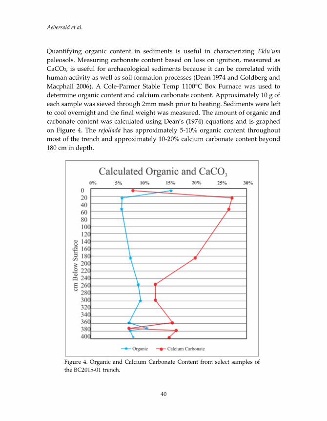
Quantifying organic content in sediments is useful in characterizing Eklu’um
paleosols. Measuring carbonate content based on loss on ignition, measured as
CaCO3, is useful for archaeological sediments because it can be correlated with
human activity as well as soil formation processes (Dean 1974 and Goldberg and
Macphail 2006). A Cole-Parmer Stable Temp 1100°C Box Furnace was used to
determine organic content and calcium carbonate content. Approximately 10 g of
each sample was sieved through 2mm mesh prior to heating. Sediments were left
to cool overnight and the final weight was measured. The amount of organic and
carbonate content was calculated using Dean’s (1974) equations and is graphed
on Figure 4. The rejollada has approximately 5-10% organic content throughout
most of the trench and approximately 10-20% calcium carbonate content beyond
180 cm in depth.
Figure 4. Organic and Calcium Carbonate Content from select samples of
the BC2015-01 trench.

The Blue Creek Rejollada Revisited
41
Phosphorus is recycled between living organisms and sediments. It is introduced
into the environment via human or animal waste, decomposing living
organisms, organic construction material, and areas with high amounts of refuse
or food-related areas. Increased amounts are indicators of human intervention in
the natural phosphorus cycle (Ayala et al. 2007; Sweetwood et al. 2009). The
Mehlich II extraction procedure was used to quantify phosphorus concentrations
in the rejollada (Terry et al. 2000). There are three peaks of interest in the trench
profile at 235 cm, 300 cm, and 395 cm in depth, which could indicate intensified
anthropogenic markers of occupation in Figure 5.
Figure 5. Mehlich Phosphorus II concentrations BC2015-01 trench.
Aebersold et al.
42
Most important, are the dates established for the rejollada from AMS dating. Of
the seven dates submitted for radiocarbon dating analysis, five dates follow a
chronology dating back to the Archaic Period or early Preclassic Period. This is
significant because at least three of the four possible anthropogenically produced
paleosols date to these periods. Both ceramic and lithic finds are well situated
within the early Preclassic paleosol AB2 and AB3 layers. The lithic tool found at
377 cm in depth dates well into the Archaic period and is situated within the AB4
paleosol. This rejollada could represent some of Blue Creek’s earliest inhabitants
and ceramic makers.
CONCLUSIONS
The 2015 field season excavation of the Blue Creek rejollada trench exhibits
distinct black, clay-rich Ab paleosol horizons, buried under coarser AC horizons.
Both ceramic and lithic artifacts are associated with paleosols much like the 2003
excavations (Beach et al. 2006; Beach et al. 2008). Upon laboratory analysis and
radiocarbon dating, it is safe to conclude that both Archaic and Preclassic
anthropogenic sedimentological imprints are visible in the rejollada. Radiocarbon
dating combined with artifact stratigraphy supports an earlier occupation than
previously documented (Guderjan 2004).
It is clear that paleosols AB2, AB3, and AB4 were products of increased
transformative behaviors by ancient people. Distinct pulses of increased
magnetic susceptibility frequency readings after 255 cm dating to Preclassic and
Archaic period paleosols could be a product of anthropogenic events such as
burning on a regional scale and a change in soil pedogenesis (Thompson and
Oldfield 1986). Increased peaks in phosphorus concentrations during correlating
increased magnetic susceptibility peaks both contribute to the conclusion that
human imprints on the landscape are visible through multiple proxies.
Results from excavation and lab work both indicate that artifacts are well
associated with the Preclassic and the lithic tool is associated with the Archaic
period. It is possible the deepest ceramic artifacts are associated with the earliest
Preclassic or latest Archaic period occupation in Blue Creek. The deepest ceramic
was found at 330 cm associated after AB3, which dates to 3340 to 3285 BP. This
finding should be further investigated because of its relative age to Cunil, some
of the earliest pottery in Belize from the Maya Lowland site of Cahal Pech.
Conservative radiocarbon dates place the Cunil ceramic tradition between 2860
The Blue Creek Rejollada Revisited
43
and 2760 BP (Early to Middle Preclassic periods) (Garber and Awe 2009; Sullivan
and Awe 2013). These dates are also comparable to Early Preclassic Kanocha
Phase ceramics at Blackman Eddy (Garber et al. 2004).
Although Lohse argues that paleosols are considered poor contexts for dating
ceramics and could reveal older dates as a result of old carbon deposited into
later deposits, this finding should be further investigated (2009). The Archaic to
Preclassic transition is a pivotal marker for increased sedentism and a change in
subsistence strategies from nomadic hunter-gatherer to horticultural and even
agricultural strategies. Finally, erosional episodes documented in the rejollada are
likely caused by deposition of Maya clays as a result of deforestation and are
correlated with dark paleosols and artifacts in the Archaic and Preclassic periods.
The rejollada sequence likely represents early inhabitants as the main cause of soil
erosion episodes based on sediment analysis and contemporaneous artifacts.
FUTURE WORK
There is still much data to extract from the 2015 trench including formal analysis
of ceramic and lithic artifacts, microbotanical analysis, and microcharcoal
analysis. There are tentative plans to complete formal artifact analysis to further
investigate the possible earliest informal occupation in Blue Creek. In addition,
pollen samples have been sent for analysis to El Colegio de la Frontera Sur by Dr.
Gerald Islebe for a more complete climatic chronology of Blue Creek. Both
phytolith and microcharcoal analysis will help determine in situ activities by
ancient peoples which lead to the social complexity and rise of Blue Creek. These
results will guide future research regarding paleosols and soil erosion in the area
in order to better understand human-environment dynamics.
REFERENCES CITED
Aebersold, Luisa, Timothy P. Beach, Sheryl Luzzadder-Beach and Thomas
Guderjan
2015 Return to the Rejollada: Investigating Buried Paleosols and Soil Erosion in
Northwestern Belize. Poster presented at the Geological Society of America
annual meeting, Baltimore, MD.

Aebersold et al.
44
Anderson, Lysanna and David Wahl
2016 Two Holocene Paleofire Records From Peten, Guatemala: Implications
for Natural Fire Regime and Prehispanic Maya Land Use. Global and
Planetary Change (138):82-92.
Ayala, G., M. Canti, J. Heathcote, J. Sidell and R. Usai
2007 Geoarchaeology: Using Earth Sciences to Understand the Archaeological
Record. English Heritage Publishing, Hawthornes, Nottingham.
Anselmetti, Flavio S., Flavio S. Anselmetti, David A. Hodell, Daniel Ariztegui
and Mark Brenner
2007 Quantification of Soil Erosion Rates Related to Ancient Maya
Deforestation. Geology 35(10):915-918.
Braje, Todd J.
2015 Earth Systems, Human Agency, and the Anthropocene: Planet Earth in
the Human Age. Journal of Archaeological Research 23(4):369-396.
Beach, Timothy, N. Dunning, S. Luzzadder-Beach, D. E. Cook and J. Lohse
2006 Impacts of the ancient Maya on soils and soil erosion in the central Maya
Lowlands. CATENA 65(2):166-178.
Beach, Timothy, Sheryl Luzzadder-Beach, Nicholas Dunning and Duncan Cook
2008 Human and Natural Impacts on Fluvial and Karst Depressions of The
Maya Lowlands. Geomorphology 101(1–2):308-331.
Beach, Timothy, Sheryl Luzzadder-Beach, Samantha Krause, Stanley Walling,
Nicholas Dunning, Jonathan Flood, Thomas Guderjan and Fred Valdez
2015 'Mayacene' Floodplain and Wetland Formation in the Rio Bravo
Watershed of Northwestern Belize. The Holocene 25(10):16121626.
Dunning, Nicholas and Timothy P. Beach
2004 Fruit of the Luum: Lowland Maya Soil Knowledge and Agricultural
Practices. Mono y Conejo 2:3-15.
The Blue Creek Rejollada Revisited
45
Dean, Walter E.
1974 Determination of Carbonate and Organic Matter in Calcareous
Sediments and Sedimentary Rocks by Loss on Ignition; Comparison with
Other Methods. Journal of Sedimentary Research 44(1):242-248.
Foley, Stephen F., Detlef Gronenborn, Meinrat O. Andreae, Joachim W. Kadereit,
Jan Esper, Denis Scholz, Ulrich Pöschl, Dorrit E. Jacob, Bernd R. Schöne,
Rainer Schreg, Andreas Vött, David Jordan, Jos Lelieveld, Christine G.
Weller, Kurt W. Alt, Sabine Gaudzinski-Windheuser, Kai-Christian Bruhn,
Holger Tost, Frank Sirocko and Paul J. Crutzen
2013 The Palaeoanthropocene – The Beginnings of Anthropogenic Environ-
mental Change. Anthropocene 3:83-88.
Gale, Stephen, J. and Peter G. Hoare
1991 Quaternary Sediments: Petrographic Methods for the Study of Unlithified
Rocks. Belhaven Press, London.
Garber, James F. and Jaime J. Awe
2009 A Terminal Early Formative Symbol System in the Maya Lowlands: The
Iconography of the Cunil Phase (1100-900 BC) at Cahal Pech. Research Reports
in Belizean Archaeology 6:152-159.
Garber, James F., M. K. Brown, J. J. Awe, and C. J. Hartman
2004 The Terminal Early Formative Kanocha Phase (1100-900 B.C.) at
Blackman Eddy. Research Reports in Belizean Archaeology 1:13-25.
Goldberg, Paul and R. I. Macphail
2006 Practical and Theoretical Geoarchaeology. Blackwell Publishing, Malden,
MA.
Guderjan, Thomas H.
2004 Public Architecture, Ritual, and Temporal Dynamics at the Maya Center
of Blue Creek, Belize. Ancient Mesoamerica 15(2):235-250.
James, L. Allan
2013 Legacy sediment: Definitions and processes of episodically produced
anthropogenic sediment. Anthropocene 2:16-26.

Aebersold et al.
46
Jones, John G.
1994 Pollen Evidence for Early Settlement and Agriculture in Northern Belize.
Palynology 18:205-211.
Kaplan, Jed O., Kristen M. Krumhardt, Erle C. Ellis, William F. Ruddiman,
Carsten Lemmen and Kees Klein Goldewijk
2011 Holocene Carbon Emissions as a Result of Anthropogenic Land Cover
Change. The Holocene 21(5):775-791.
Kennett, Douglas J. and Timothy P. Beach
2013 Archeological and Environmental Lessons for the Anthropocene from
the Classic Maya Collapse. Anthropocene 4(0):88-100.
Krause, Samantha, Aebersold, L., Beach, T., Luzzadder-Beach, S., Eshleman, S.
(Under Review) Geoarchaeological Excavations at Maya Research Program. In The
24th Annual Report of the Blue Creek Archaeological Project. Edited by C. Colleen
Hanratty and Thomas H. Guderjan. Maya Research Project, University of
Texas at Tyler.
Lohse, Jon C.
2009 The Archaic-to-Preclassic Transition in Belize: What We Know and Why
We Don’t Know More. Research Reports in Belizean Archaeology 6: 141-150.
Lohse, Jon C.
2010 Archaic Origins of the Lowland Maya. Latin American Antiquity 21(3):312-
352.
Munro-Stasiuk, Mandy J., T. Kam Manahan, Trent Stockton and Traci Ardren
2014 Spatial and Physical Characteristics of Rejolladas in Northern Yucatán,
Mexico: Implications for Ancient Maya Agriculture and Settlement Patterns.
Geoarchaeology 29(2):156-172.
Piperno, Dolores R.
2009 Identifying Crop Plants with Phytoliths (and Starch Grains) in Central
and South America: A Review and an Update of the Evidence. Quaternary
International 193(1–2):146-159.
The Blue Creek Rejollada Revisited
47
Piperno, Dolores. R. and Deborah M. Pearsall
1998 The Origins of Agriculture in the Lowland Neotropics. Academic Press, San
Diego.
Pohl, Mary D., Kevin O. Pope, John G. Jones, John S. Jacob, Dolores R. Piperno,
Susan D. deFrance, David L. Lentz, John A. Gifford, Marie E. Danforth and J.
Kathryn Josserand
1996 Early Agriculture in the Maya Lowlands. Latin American Antiquity
7(4):355-372.
Rice, Prudence M.
2007 Maya Calendar Origins: Monuments, Mythistory, and the Materialization of
Time. University of Texas Press, Austin.
Rosenswig, Robert M., Deborah M. Pearsall, Marilyn A. Masson, Brendan J.
Culleton and Douglas J. Kennett
2014 Archaic Period Settlement and Subsistence in the Maya Lowlands: New
Starch Grain and Lithic Data from Freshwater Creek, Belize. Journal of
Archaeological Science 41(0):308-321.
Ruddiman, W. F.
2013 The Anthropocene. Annual Reviews of Earth and Planetary Sciences 41(4.1-
4.24).
Smith, Bruce D.
2011 General Patterns of Niche Construction and the Management of ‘Wild’
Plant and Animal Resources by Small-Scale Pre-Industrial Societies.
Philosophical Transactions of the Royal Society B: Biological Sciences
366(1566):836-848.
Solís-Castillo, Berenice, Elizabeth Solleiro-Rebolledo, Sergey Sedov, Rodrigo
Liendo, Mario Ortiz-Pérez and Sara López-Rivera
2013 Paleoenvironment and Human Occupation in the Maya Lowlands of the
Usumacinta River, Southern Mexico. Geoarchaeology 28(3):268-288.
Aebersold et al.
48
Sullivan, Lauren A. and Jaime J. Awe
2013 Establishing the Cunil Ceramic Complex at Cahal Pech, Belize. In Ancient
Maya Pottery: Classification, Analysis, and Interpretation, edited by J. J. Aimers,
pp. 107-120. University Press of Florida.
Sweetwood, Ryan V., Richard E. Terry, Timothy P. Beach, Bruce H. Dahlin and
David Hixson
2009 The Maya Footprint: Soil Resources of Chunchucmil, Yucatán, Mexico
Soil Sci. Soc. Am. J. 73(4):1209-1220.
Targulian, Victor O. and Sergey V. Goryachkin
2004 Soil Memory: Types of Record, Carriers, Hierarchy and Diversity. Revista
Mexicana de Ciencias Geológicas 21:1-8.
Terry, Richard E., Sheldon D. Nelson, Jared Carr, Jacob Parnell, Perry J. Hardin,
Mark W. Jackson and Stephen D. Houston
2000 Quantitative Phosphorus Measurement: A Field Test Procedure for
Archaeological Site Analysis at Piedras Negras, Guatemala. Geoarchaeology
15(2):151-166.
Thompson, Roy and Frank Oldfield
1986 Environmental Magnetism. Allen & Unwin (Publishers) Ltd, London.
Zeder, Melinda A., Daniel G. Bradley, Eve Emshwiller and Bruce D. Smith
(editors)
2006 Documenting Domestication: New Genetic and Archaeological Paradigms.
University of California Press, Berkeley, Calif.
Zizumbo-Villarreal, Daniel, Alondra Flores-Silva and Patricia Colunga-García
Marín
2012 The Archaic Diet in Mesoamerica: Incentive for Milpa Development and
Species Domestication. Economic Botany 66(4):328-343.
SOCIAL TECHNOLOGY: THE PRODUCTION OF HYPHENATED AND HYBRID CERAMICS WITHIN ROMANIZED IBERIA
Elizabeth M. de Marigny, The University of Texas at Austin
INTRODUCTION Pottery constitutes one of the most important forms of material evidence for archaeological inquiry into ancient societies. This is because pottery is found in contexts of cultural interaction, ranging from food preparation and consumption to daily and ritual activities (Roth 2007). The study of ceramics in archaeology is significant for understanding historical moments that influenced ancient cultures. Despite its status as fine or plain ware, pottery was a crucial aspect of everyday life that acquired meaning through use in activities. The production and use of ceramics can answer questions of broad implications for economic anthropology and social archaeology through the actions and agency of both local producers and consumers. The adaptation, adoption or abandonment of certain ceramic materials within the scope of a colonized space can highlight shifts in cultural identity and cultural practice before and after colonial expansion. The focus of this paper will investigate the technological changes that occurred within the Castro Culture after Roman expansion into the Iberian Peninsula. Specifically, I will discuss the changes in ceramic production that occurred at the Cividade of Bagunte, a fortified hillfort settlement located in northwestern Portugal. THE HISTORY OF BAGUNTE AND THE IBERIAN PENINSULA The Cividade of Bagunte is a hillfort settlement occupied from the Late Bronze Age through the Roman Period, located about thirty kilometers from Porto and about twelve kilometers from Vila do Conde. The archaeological site is 206 meters above sea level and occupies approximately 32 acres of forested land. The high hill, with a viewshed that includes the Atlantic Ocean as well as various other castros, is oriented NE/SW and the north escarpment runs parallel to the River Este, an affluent of the River Ave (Dinis 1993). The cultural characteristics of the Iberian Peninsula were formed by Atlantic, Mediterranean and Continental influences, as well as existing local traditions. This contact made the Iron Age a time of complex change with little evidence of material chronological homogeneity. Such changes include: the definitive
49

de Marigny
settlement of populations; the marking of political territories; the intensification of agriculture, particularly through the introduction of iron tools; the development of social hierarchy; and lastly, ideological changes.
Figure 1 (left): Roman territories in the northwestern Iberian Peninsula (Gonzáles‐Ruibal 2004). Figure 2 (right): Map of Bagunte and surrounding castros by Jordan Bowers. Colonization on the Iberian Peninsula began around the ninth century B.C.E by the Phoenicians when trading ports along the southern coast were established. The foundation of New Carthage by General Hasdrubal was the start of territorial expansion and control and was facilitated by the support of local, indigenous aristocracies. Hasdrubal and his brother Hannibal married Iberian princesses and eventually became recognized as leaders by local populations (Dietler 2009). This unification fueled the power of Carthage, ultimately threatening Roman supremacy. In 219 B.C.E., Rome went to war with the Carthaginians in Iberia following the sack of Saguntum, a city allied with Rome. This conflict, known as the Second Punic War, continued until 202 B.C.E. when Scipio defeated the Carthaginians and established Rome’s first Hispanic colony at Italica, near modern day Seville (Dietler 2009).
50

Social Technology
Table 1. Roman Campaigns in northwestern Iberia adopted from Little, 1990. Roman Campaigns in northwestern Iberia
138‐136B.C.E. Campaign of D. Iunius Brutus 96‐94 B.C.E. Campaign of P. Licinius Crassus 61 B.C.E. Campaign of C. Iulius Caesar 26 B.C.E. Augustus Caesar begins final conquest 19 B.C.E. Final defeat of tribes in northwest Iberia
This victory gave Rome control of coastal southeastern Spain, and in 197 B.C.E. the provinces of Hispania Citerior and Hispania Ulterior were created. The Augustan campaigns furthered territorial expansion throughout the region, including the exploitation of metal resources for Rome and, in particular, the extensive gold reserves of Terraconensis, reorganized from Hispania Citerior in 27 B.C.E. Iberian oil was also exported to Gaul and Britain and fish sauce (garum), produced at many sites on the Iberian coast, was shipped to both Italy and Britain (Dietler 2009). Thus, as exportation of Iberian goods increased, the production and use of storage, transport and utilitarian ceramics amplified. As Roman mining declined throughout northeastern Iberia in the second half of the first century B.C.E., the last quarter of the century appears to have registered a period of Roman expansion and migration into rural and agricultural sites in the northwest (Orejas and Sánchez 2002). As mining settlements declined in both production and population, rural sites experienced an increase in population as well as in infrastructural changes (Parcero and Cobas 2004). Eventually, Rome organized communities within Iberia into civitates. These centers formed the basis for new socioeconomic and political relationships. Within the civitates, castros were the most common form of settlement. Castros are most commonly located at elevations between 200 and 500 meters above sea level. The majority are fortified by concentric stone walls that encompass terrace levels that hold single‐room dwellings or structures. Smaller stone walls found at some castro sites may have acted as barriers for agricultural practices or territory markers. Regardless, the predominance of these types of settlements represents an important transition for the Castro Culture and its inhabitants. Urban centers became more permanent and developed, ultimately allowing for future economic growth and expansion that would inevitably occur post‐Romanization.
51

de Marigny
CERAMICS IN IBERIA PRE‐AND‐POST ROMANIZATION Analysis of the landscape of territories the Romans conquered in the ancient world can help identify processes by which space was claimed, appropriated, and transformed, as well as the ideological, social, economic, and administrative structures of the people laying claim to it (Orejas and Sanchez 2002). In the case of the Iberian Peninsula, Roman occupation and exploitation left visible marks of productive intensification and diversification on the landscape. These changes created morphological standardization in socioeconomic relations, settlement, and land use, but most importantly they brought changes in technology. Due to the social changes that took place throughout northwestern Iberia from the sixth century B.C.E. until at least the fifth century C.E., it is necessary to classify modifications and changes that occurred overtime in ceramic production. The ceramic assemblage from Bagunte tells a story about the gradual, but evident change in ceramic styles, including form and paste that hint not only at Roman influence, but also at the processes local craftsmen followed to adapt to new and emerging styles during the Roman Period. The development of typological groups through the use of modes based on form, function and specific cultural attributes is essential for the analysis of ceramic assemblages. Identifying the chronology for ceramic production within Bagunte is key to understanding the history of the site and the cultural practices associated with its inhabitants before and after Roman colonization. The same type of vessel can be found in a variety of contexts and as part of differently composed assemblages. Depending on these contextual associations, the meaning of identical ceramic materials can vary. Likewise with form, the design of a vessel may change slightly overtime and appear to be minor when in all actuality it could represent a meaningful transition within technological cultural interactions (Roth 2007). These traits can point out ceramic forms that originated from the Castro Culture and the potential uses that they employed. They can also aid in seeing how the introduction of new technologies or adaptation of Roman forms were incorporated within cultural use and in the production of new materials. The ceramic assemblage uncovered at Bagunte has yielded an interesting collection of vessels that were either produced by the Castro Culture, imported from Rome, or a hybrid, hyphenated group of materials I refer to as Castreja‐Roman.
52
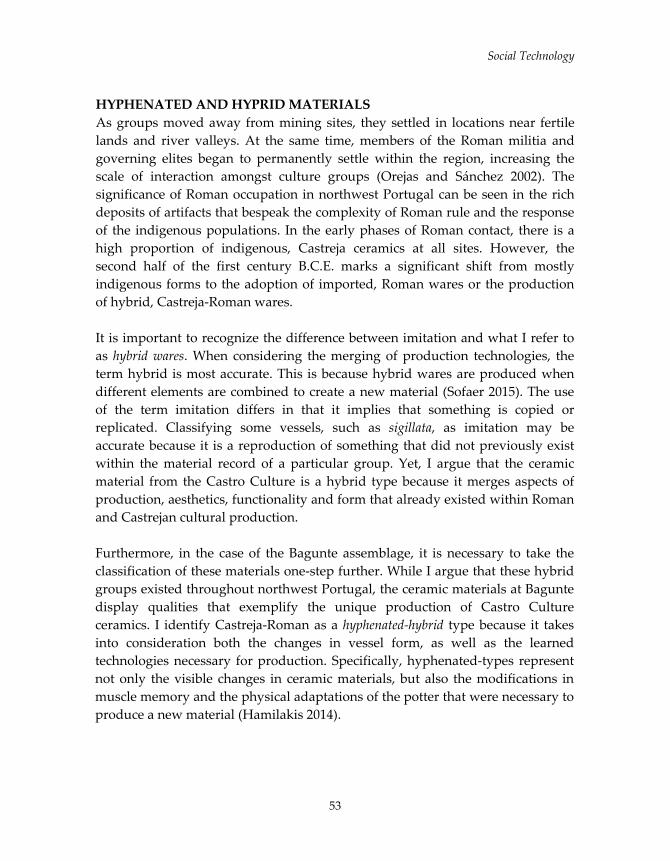
Social Technology
HYPHENATED AND HYPRID MATERIALS As groups moved away from mining sites, they settled in locations near fertile lands and river valleys. At the same time, members of the Roman militia and governing elites began to permanently settle within the region, increasing the scale of interaction amongst culture groups (Orejas and Sánchez 2002). The significance of Roman occupation in northwest Portugal can be seen in the rich deposits of artifacts that bespeak the complexity of Roman rule and the response of the indigenous populations. In the early phases of Roman contact, there is a high proportion of indigenous, Castreja ceramics at all sites. However, the second half of the first century B.C.E. marks a significant shift from mostly indigenous forms to the adoption of imported, Roman wares or the production of hybrid, Castreja‐Roman wares. It is important to recognize the difference between imitation and what I refer to as hybrid wares. When considering the merging of production technologies, the term hybrid is most accurate. This is because hybrid wares are produced when different elements are combined to create a new material (Sofaer 2015). The use of the term imitation differs in that it implies that something is copied or replicated. Classifying some vessels, such as sigillata, as imitation may be accurate because it is a reproduction of something that did not previously exist within the material record of a particular group. Yet, I argue that the ceramic material from the Castro Culture is a hybrid type because it merges aspects of production, aesthetics, functionality and form that already existed within Roman and Castrejan cultural production. Furthermore, in the case of the Bagunte assemblage, it is necessary to take the classification of these materials one‐step further. While I argue that these hybrid groups existed throughout northwest Portugal, the ceramic materials at Bagunte display qualities that exemplify the unique production of Castro Culture ceramics. I identify Castreja‐Roman as a hyphenated‐hybrid type because it takes into consideration both the changes in vessel form, as well as the learned technologies necessary for production. Specifically, hyphenated‐types represent not only the visible changes in ceramic materials, but also the modifications in muscle memory and the physical adaptations of the potter that were necessary to produce a new material (Hamilakis 2014).
53

de Marigny
The creative decisions made by the potter did not emerge within a vacuum, but through cultural connectivity and the transmission of knowledge (Pope 2005). Creativity in technological production is socially learned and understood, thus the way in which groups appropriate materials is an attempt to adapt them to their own cultural economy (Sofaer 2015). In the case of ceramics, there is a relationship between the producer and the consumer that governs the performance of knowledge. Objects, in this case ceramics, have specific values and act out roles that are embedded in cultural identity (Singer 1972). The adoption or abandonment of an object does not randomly take place, but occurs when objects are used in a way that connects people. More specifically, the performance between an individual and a thing provides a mode of communication that determines the need for an object. Fundamental to the relationship between the producer and consumer is workmanship of risk vs. workmanship of certainty (Pye 1968). All man‐made things are designed consciously, or not (Sofaer 2015). Yet it is fundamental to remember that objects are deliberately made for specific purposes. The existence of anything is tied to the initial realization that it is needed. This is the starting point for production, the initial phase when the certainty of need enables production. However, the introduction of something that already exists, but is slightly modified or is completely new represents workmanship of risk, where the rejection or adoption of an object is governed by societal attitudes and expectations. This process takes time; it goes against human nature to automatically accept change. More importantly, however, it forces the potter and the consumer to acquire knowledge of new materials and skills, which eventually alters social identity. The process of learning something new cannot happen in isolation, it occurs in multicultural spaces. This diffusion of knowledge allows for risk in production and ultimately cultural change (Pye 1968). From the potter’s point of view, learning is both behavioral and physical. It is a process of both bodily and social conditioning. The skill required for production is a process, where time and rhythm are reflected by muscle memory (Norman 2004). For example, when learning to type, at first you have to look at the keys, trying to memorize each individual place where they are located. But over time, you memorize where they are, your speed increases, and you become more efficient at typing. Your hands become a specialized tool for completing a task.
54
Social Technology
This is the same process for the potter where, over time, muscle memory takes over. However, not all keyboards are the same, some have number pads, some do not, or the location of each key varies. When you use a different style of keyboard your fingers fumble and you have to acquire that muscle memory in order to adapt. For the potter, new forms or modifications required the same adaptation, their success was determined by their ability to expand their muscle memory. Thus the producer himself becomes a specialized tool that reflects learned behavior (James and Allen 1998). Their hands and bodies become mechanisms that are guided by memory, rather than thought (Heidegger 1977). ROMANIZATION AT BAGUNTE The reuse of Roman storage vessels such as amphorae and the production of Roman forms by local potters is significant in understanding the scale of Romanization that occurred at Bagunte. First, the ceramic assemblage uncovered has a high proportion of both table and transport amphorae. These portable storage jugs were employed for packaging, distribution and post‐distribution storage of foodstuffs. Additionally, as the Roman military and elite continued to migrate and settle throughout Iberia, imported Roman utilitarian and fine wares were successfully introduced to local populations. A few examples of Roman oil lamps, Terra Sigillata and Roman utilitarian wares have been found at Bagunte. Most often these types of wares have been found near structures located on the acropolis. While it is unclear exactly what the purpose of these buildings were, it seems likely that they were domestic structures. Ceramics found near these structures at Bagunte are from mixed assemblages of Roman, Castreja and Castreja‐Roman materials. This indicates that all three types were being used within households throughout the site. The successful incorporation of these materials signifies the extent of economic, sociopolitical and technological changes that took place during the Roman Period. There are a few differences in the ceramic material between the Late Iron Age and the Indigenous‐Roman Period. However, these differences are slight and may not be considered as a break from one form of production to a newer form. The objective difference is in vessel morphology. It needs to be noted that the use of the term Castreja when referring to ceramics found at Bagunte is an identifier for styles of indigenous pottery originally produced before Roman colonization.
55
de Marigny
Throughout the region and more generally in the Late Bronze Age and Early Iron Age, pottery was constructed without the use of a potter’s wheel. This is evident in the analysis and observation of pinholes in vessel walls, as well as the absence of pottery with markings from the use of a wheel (Pacero and Cobas 2004). Yet, during the Middle Iron Age, new forms appear that have changes in modeling techniques indicating the use of the potter’s wheel (Silva, A.C.F. 1983). Among other significant modifications that occurred in ceramic production at this point is the gradual shift in clay and temper materials. Early Castreja ceramics were formed using dark grey and dark brown clay. Temper used in the production of these vessels is made up of high amounts of mica, medium to large in size, and angular in shape. The quantity, quality and visibility of the temper indicate that in most cases, the paste used for production was not well wedged. Moreover, Roman pottery found within the region, as well as Roman pottery within the archaeological record in general, is typically constructed from lighter, red‐orange clay, with small, fine inclusions that are better incorporated within the paste. Yet, with the introduction of Roman wares, Castreja pottery not only begins to adopt Roman forms or attributes, but also the use of lighter grey and brown pastes. Temper in this new Castreja‐Roman ware begins to include quartz as well as mica that are small in size, rounded and less visible than before. While the quantity of temper used in production at this time can still be significant, it is clear that a finer material was adopted. Additionally, from previous studies done on ceramic assemblages from the surrounding region, new firing techniques were adopted over time. The temperatures of the firing environments ranged from 426 to 538 degrees Celsius (Little 1990). During the earliest periods, firing was done in a reduction atmosphere. This created uneven coloring and clouding on the external surface of vessels. In contrast, during the Late Iron Age and the Roman Period, firing was mostly done in an oxidizing environment. Wares in a range of brown hues are the most common colors of ceramic from this period, with little to no clouding on external surfaces (Parcero and Cobas 2004). Bagunte’s Iron Age and Roman Period ceramics also show evidence of smoothing, application of a wash or slip, and burnishing. In contrast to earlier production phases, vessels made during this time appear to be more uniform, both stylistically and morphologically. This indicates that developments in new technologies were advancing and that potters were becoming more specialized in the creation of
56

Social Technology
new materials. Moreover, typical Roman forms were being produced at Bagunte using local materials and decorated with “Celtic” motifs. This results in a mixed assemblage of hyphenated‐hybrid wares that were crafted using various techniques and production technologies. These changes represent a merging of technologies and aesthetics at both the production and consumption levels, representing ideological changes from contact between the Roman and Castro Cultures. CONCLUSION The ceramic assemblage from Bagunte contains imported, local and hybrid‐hyphenated materials that are associated with household and trade functions. Imitation wares are rare, indicating the significance of the Castreja‐Roman material that has been uncovered. This contextual association highlights the standardization of socioeconomic relations that occurred through the transmission of new production technologies. It also represents the adoption of new materials used for daily and ritual activities. These interactions, whether it was between culture groups, or between individuals and things, are significant because they represent the scale of cultural interaction occurring. The assemblage at Bagunte represents a timeline for social and technological change, which highlights shifts in cultural practices before and after Roman expansion. Thus, the study of pottery provides a link between the archaeologist and the human actors of the past who would have used ceramics in a way that made sense to them within a particular context (Hamilakis 2014). If you are looking at two assemblages, in this case, Roman and Castreja pottery, it is crucial to focus on this contextual association as well as the forms represented. These contextual associations represent a meaningful display of cultural adaptation and diffusion that takes place in mixed landscapes. More importantly, they represent the types of interactions that occurred between culture groups and the way in which technological changes promoted cultural connectivity. REFERENCES CITED Dietler, Michael 2009 Colonial Encounters in Iberia and the Western Mediterranean: An
Exploratory Framework. In Colonial Encounters in Ancient Iberia: Phoenician, Greek, and Indigenous Relations, edited by Michael Dietler and Carolina López‐Ruiz, pp. 3‐48. The University of Chicago Press.
57
de Marigny
Dinis, António Pereira 1993 ʹOrdenamento do território do Baixo Ave no I milénio aCʹ, Universidade
do Porto. González‐Rubial, Alfredo 2004 Artistic Expression and Material Culture in Celtic Gallaecia. e‐Keltio:
Journal of Interdisciplinary Celtic Studies 6: 113‐166. Heidegger, Martin 1977 The Question Concerning Technology. Reprinted. Garland Publishing.
Originally published 1954, Vorträge und Aufsätze, Germany. Little, Georgeana M 1990 The Technology of Pottery Production in Northwestern Portugal during the
Iron Age. Ph.D. Dissertation, Boston University, James, Wendy, and N. J. Allen 1998 Marcel Mauss: A Centenary Tribute. New York: Berghahn Books. Orejas, Almudena, and F. Javier Sanchez‐Palencia 2002 Mines, Territorial Organization, and Social Structure in Roman Iberia:
Carthago Noua and the Peninsular Northwest. American Journal of Archaeology 106.4: 581‐99.
Parcero Oubina, Cesar, and Isabel Cobas Fernandez 2004 Iron Age Archaeology of the Northwest Iberian Peninsula. Journal of
Interdisciplinary Celtic Studies 6: 1‐72. Peña, J. T 2007 Roman Pottery in the Archaeological Record. Cambridge University Press. Pope, Rob 2005 Creativity: Theory, History, Practice. Routledge, New York; London. Pye, David 1968 The Nature and Art of Workmanship. Cambridge University Press, London.
58
Social Technology
Queiroga, Francisco Manuel 1992 War and Castros. Ph.D. Dissertation, Oxford University. Roth, Roman 2007 Styling Romanisation: Pottery and Society in Central Italy. Cambridge
University Press. Silva, Armando Coelho Ferreira da 1983 A Idade dot Metain em Portugal, História de Portugal. Lisboa, Publicacoes
Alfa. Silva, Maria Antonia Dias da 1997 A Ceramica Castreja da Citania de Briteiros. Sociedade Martins Sarmento. Sofaer, Joanna R 2015 Clay in the Age of Bronze: Essays in the Archaeology of Prehistoric Creativity.
Cambridge University Press.
59

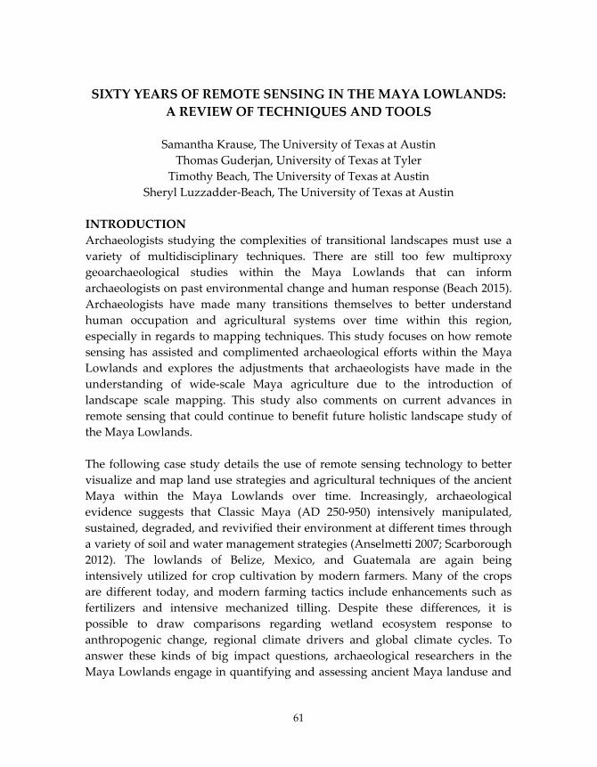
SIXTY YEARS OF REMOTE SENSING IN THE MAYA LOWLANDS: A REVIEW OF TECHNIQUES AND TOOLS
Samantha Krause, The University of Texas at Austin
Thomas Guderjan, University of Texas at Tyler Timothy Beach, The University of Texas at Austin
Sheryl Luzzadder‐Beach, The University of Texas at Austin INTRODUCTION Archaeologists studying the complexities of transitional landscapes must use a variety of multidisciplinary techniques. There are still too few multiproxy geoarchaeological studies within the Maya Lowlands that can inform archaeologists on past environmental change and human response (Beach 2015). Archaeologists have made many transitions themselves to better understand human occupation and agricultural systems over time within this region, especially in regards to mapping techniques. This study focuses on how remote sensing has assisted and complimented archaeological efforts within the Maya Lowlands and explores the adjustments that archaeologists have made in the understanding of wide‐scale Maya agriculture due to the introduction of landscape scale mapping. This study also comments on current advances in remote sensing that could continue to benefit future holistic landscape study of the Maya Lowlands. The following case study details the use of remote sensing technology to better visualize and map land use strategies and agricultural techniques of the ancient Maya within the Maya Lowlands over time. Increasingly, archaeological evidence suggests that Classic Maya (AD 250‐950) intensively manipulated, sustained, degraded, and revivified their environment at different times through a variety of soil and water management strategies (Anselmetti 2007; Scarborough 2012). The lowlands of Belize, Mexico, and Guatemala are again being intensively utilized for crop cultivation by modern farmers. Many of the crops are different today, and modern farming tactics include enhancements such as fertilizers and intensive mechanized tilling. Despite these differences, it is possible to draw comparisons regarding wetland ecosystem response to anthropogenic change, regional climate drivers and global climate cycles. To answer these kinds of big impact questions, archaeological researchers in the Maya Lowlands engage in quantifying and assessing ancient Maya landuse and
61

Krause et al.
(Dunning 2000, Guderjan 2007), develop models for natural and anthropogenically influenced hydrologic patterns (Beach 2005b), and identify anthropogenically induced vegetation change over time (Wahl 2014). Remote sensing technology intersects elegantly with these environmental questions as it provides a multi‐component spatial platform in which to visualize and quantify the remnants of ancient land use strategies. ARCHAEOLOGICAL BACKGROUND OF THE MAYA LOWLANDS This particular review focuses on some of the most recent iteration of over twenty years of intensive archaeological research along the border of Belize and Mexico, which is a major area of focus within the sixty plus years of intensive Maya agricultural exploration and mapping within the greater Maya Lowlands. We review work centered on the ancient Maya site of Blue Creek, and expanding northeastward along the length of the Rio Hondo (Figure 1). The purpose of this ongoing research is to better understand the scale and scope of large agricultural systems, macro‐economics, and environmental adaptation in this region, particularly during the Maya Classic and Post Classic time periods. Prior to the late 1960s, most archaeologists in the Maya Lowlands subscribed to the idea that ancient populations in this region subsisted completely on small agroforestry efforts, household gardens, and swidden agriculture methods (Seimans 1972). While all of these methods of agriculture have been documented at various sites throughout the ancient Maya world, by the late 1960s and into the 1970s, archaeologists began to consider that the higher population densities, especially within the Maya Lowlands, must have demanded a more intensified agricultural system of terraces and raised field systems that spanned many hectares across various environments; bajos, inundated wetlands, broad savannas, and upland forests alike (Turner 1974). First, intensive pedestrian and aerial surveys and then both passive and remote sensing demonstrated the vast Maya imprint on the environment within this region (Figure 2).
62

Sixty Years of Remote Sensing
Figure 1. General Location Map and Example of Ditched Field Systems along the Rio Hondo.
63

Krause et al.
Figure 2. A variety of media depicting ancient Maya agricultural modifications. Researchers working along the Rio Candelaria in Campeche, Mexico, were some of the first to notice and consider patterned features that were interpreted as extensive field and canal systems near the Maya site of El Tigre (Siemens 1972). Siemens and his coauthor Puleston at that time drew heavily on the prehistoric and history agricultural features that had been documented in other sites across other regions in the Americas, such as the chinampas of Mexico (Coe 1964) and
64

Sixty Years of Remote Sensing
the early work on camellones (ridged field systems) of Ecuador, Bolivia and Peru (Denevan 1970). Shortly after Siemens and Puleston began to document the Rio Candelaria field systems, B. L. Turner published his own finding regarding ancient Maya agriculture. Turner (1976, 1981) documented a series of large scale terraces over a 10,000 square kilometer area along the Rio Bec, which runs through the Mexican states of Campeche and Quintana Roo. These early Rio Bec field systems have continued to play a part in better understanding the social dimensions of “micro‐regions” and “nuclear zones” of habitation during the Maya Classic period (Lemonnier, 2013; Nondédéo 2013). Only a few years after these initial systems were identified along the Rio Candelaria and Rio Bec, strikingly similar features were discovered along the Belize‐Mexico border on the Hondo river (Jacob 1995). Siemens estimated in 1983 that there were at least 3,200 hectares of anthropogenically modified field systems within these Belizean wetland systems. Robust debate ensued over the next several over exactly what the extent of these features could be quantified to, specifically in the case of “how anthropogenic” these features actually were throughout wetland systems (Jacob 1995). Currently, more emphasis is being placed on quantification, excavation, and new technological efforts of these features to determine how they tie into the urban setting, timeline, and subsistence of the ancient Maya (Guderjan 2011, Harrison‐Buck 2013, Harrison‐Buck 2015). Perhaps these early debates concerning the validity of these were warranted, as early remote sensing and soil geomorphology techniques needed to catch up with the research question at hand. Early efforts to quantify the extent of ancient agricultural systems using oblique angle photography and SEASAT synthetic aperture radar (Adams 1981) in the southern Maya Lowlands were largely criticized Pope and Dahlin in 1989 due to problematic radar data (Adams 1990). These early data sets certainly provoked more scrutiny into the authenticity of these cultural features. Many critics denounced this original aerial survey because of the claim that it grossly exaggerated the amount of anthropogenic modification on the landscape (Adams 1990). We must, however, recognize these early efforts as an attempt for archaeologists to transition to a more holistic understanding of the Maya landscape through the use of a new vantage point and recognize the plethora of remotely sensed data that has been procured by a variety of researchers following these first efforts. These primary endeavors marked the first time within Mesoamerican
65

Krause et al.
archaeology that remote sensing efforts were considered as a valuable resource in which to employ a scale driven analysis of agricultural patterns throughout the Maya Lowlands. In the 1990s, excavations of Maya sites and associated agricultural feature intensified along the Rio Hondo. Similar research projects were conducted by Pohl and Pope around Albion Island, a Maya site next to the Rio Hondo (Pohl 1990, Fedick 1996). In the early 2000s, Pyburn focused excavations on water control features at the site of Chau Hiix in the Crooked Tree wetlands along the New River (Pybyun 2003). Meanwhile, Guderjan and his collaborators recognized canal systems at the site of Blue Creek (Beach 2009, Beach 2011) and began an extensive campaign to better understand the paleoecological significance of these features. In the mid‐late 2000s, Steven Bozarth’s work on ancient agricultural systems around the Blue Creek area yielded pollen evidence for a variety of different cultivans, including maize (Zea mays), sweet potato, breadnut, cacao, avocado, wild banana, and various other types of agricultural plants (Beach 2009). Based on these intensive excavations around the Three Rivers Region, scholars have developed several complex and finely resolved models of human‐wetland interaction and Maya occupation and resilience over different time periods. These kinds of multi‐proxy projects highlight how wetland patterned field research has shifted over the years. Maya archaeologists have moved from the question of whether or not these systems are anthropogenically modified to different questions. Today, the focus of research has turned to wetland development, preoccupation through abandonment, cultivation strategies, and shifting environments in the face of large scale regional drought patterns (Luzzadder‐Beach 2012, Harrison‐Buck 2014, Dunning 2015). Remote sensing efforts are an important component to this research, especially around the site of Blue Creek and along the Rio Hondo. NATURAL ENVIRONMENTAL CONSIDERATIONS Understanding the natural geomorphology of the Maya Lowlands is an important component to mapping and remote sensing efforts. Within wetland environments, several distinct natural patterns emerge due to pedoturbative processes. Wetlands, especially tropical wetland areas within the Maya Lowlands, are situated on a bedrock primarily composed of back‐reef, lagoonal limestone (Beach 2015). This karst‐dominated environment has a ground water table that is very near to the surface, promoting the development of wetland soils, primarily Histosols and Veritsols (Beach 2015). Wetland morphology processes in this area include, but are not limited to the following formation
66
Sixty Years of Remote Sensing
development: Giglai Patterned Relief, Tree Islands, and Ridge and Slough feedback systems. Each of these wetland features has been studied and considered by tropical system archaeologists, soil geomorphologists, and wetland biologists alike in the tropical Americas and beyond (Turner 1981, Watts 2014), yet there is still much the be gleaned regarding soils formation, environmental feedback loops, biologic modification (including anthropogenic factors), and the formations that arise from the combinations of all of these processes. Current remote sensing efforts consider visualization techniques that can assist in determining which environments are likely to be anthropogenically modified, which are exhibiting natural wetland morphology, and which are likely to be a combination of ancient human modification and natural processes. Remote sensing of these areas helps to inform archaeologists currently working within the Maya Lowlands as the most fruitful areas in which to focus pedestrian survey efforts as well as excavation. DATA ACQUISITION AND METHODS 2010‐2011 Guderjan (2011) documents this most recent phase of wetland pattern quantification along the Rio Hondo as beginning with a series of flights in a small aircraft from the modern Mennonite village of Blue Creek to just southwest of Corozal Bay, the Belizean town that borders the Mexican town of Chetumal, Quintana Roo. The 2010 flights were reconnaissance missions primarily, our main goal was to determine whether we could visually identify and document ditched field systems using GIS technologies and begin building a database of oblique aerial photographs and ground truth data for field patterns along this river system. Time stamps on the photographs along with a hundreds of track logs taken with a Garmin Oregon 550 series. Each set of photographs and track log from the GPS was organized within a database using ESRI’s ArcGIS 9.3 and the ArcPhoto tool script. This extension called ESRI’s ArcPhoto Tools is a set of geoprocessing tools that enhances the ArcMap user interface. The extension allows the user to quickly import a large set of digital photographs into the framework of the map. These photos are tied to georeferenced points and are quickly displayed on the map as a set of “map tips”, thumbnail images that can serve as annotations or visual reminders for the vector point features (Figure 3). This is a rapid method for transforming usually bulky data sets such as large photo sets into spatial features.
67
Krause et al.
Figure 3. Examples of data management during 2010‐2011 field efforts. Along with the hundreds of track record points and just as many georeferenced photos taken from these initial flight series, we collected a series of ground truth points on landmarks along the flight path to insure spatial data quality for the
68

Sixty Years of Remote Sensing
entire database. Ground truth points were mostly collected along cross roads, and on buildings in towns along the river that were easily distinguishable from the air. DATA ACQUISITION AND METHODS 2012‐2013 These original explorative surveys yielded intriguing results detailed by Guderjan in 2011. In summary, we were able to document at least fourteen sets of ditched fields in the Río Hondo floodplain, several of which have certainly been studied in previous work, especially those around Albion Island. The preliminary results of the 2010‐2011 field seasons encouraged the research team to continue efforts in visualization and remote sensing throughout this area. The research team hypothesized that the presence of these canal features could be revealing only a small part of a much larger ancient agricultural system, due to natural wetland deposition and infilling, along with a combination of reforestation in some areas, and intensive modern plowing and urbanization in other areas along the river. In 2012, Colleen Hanratty and Thomas Guderjan of the Maya Research Program (MRP) pursued a research grant to procure Geoeye multispectral imagery for the length of the Rio Hondo that was identified in the 2010‐2011 surveys (Figure 4). This image set was obtained with a grant through the Geoeye/DigitalGlobe. MRP acquired a set of satellite images that were obtained from the IKONOS satellite in the winter of 2013. This satellite is multispectral, and utilizes five bands, the panchromatic band, the red, green, blue bands, and the near infrared bands, orbiting the earth at 681 km, with a three day revisit time (Parcak 2009). The resolution for the IKONOS sensor is 0.8 m for color imagery and 3.2 m for the near infrared band. Although this satellite uses less bands than Landsat, a great deal of information can be gleaned from various processing techniques and pattern recognition algorithms detailed in the previous sections of this report.
69

Krause et al.
Figure 4. Swath of Geoeye multispectral imagery along the Rio Hondo.
70

Sixty Years of Remote Sensing
We preformed all image transformations and visualization techniques with ERDAS Imagine 9 software. Transformed images were then transferred over the MRP GIS geodatabase, run through ESRI’s ArcGIS 9.3‐10 software package. In ERDAS, the Geoeye multispectral imagery of the project area was first layer stacked in the RGB color bands. We then used the mosaic tool to combine the georeferenced and layer stacked images for easy visualization of the entire swath of data for the Rio Hondo. We created several copies of this RGB mosaic image of the data swath was to perform a variety of statistical analyses on the imagery. Using the IMAGINE software, we applied a variety of edge detection filters on the imagery to determine the best filters to use when attempting to locate new canal features. The software uses Gaussian smoothing kernels to process these different edge detection filters. A default kernel library containing some of the most common convolution filters is supplied with IMAGINE, and so we were able to explore a variety of techniques, including 3x3 Edge Detect, 3x3 Edge Enhance, 3x3 Haze Reduction, and more. These techniques were used after Lasaponara and Masini in 2006, and a qualitative visual comparison of the imagery after edge detection filters yielded a quicker visualization of patterned landscapes along the Rio Hondo. This simple technique, however, cannot be used to determine whether or not the emerging patterns are natural or anthropogenic. We used ERDAS to apply an NDVI (normalized difference vegetation index) analysis to the imagery (Figure 5a and 5b). Traditionally, NDVI has been used primarily by biologists and ecologists with the primary goal of monitoring vegetation health and vigor (Lasaponara 2006, Schowengerdt 2007). NDVI is a quantitative measure of biomass vigor. This function acquires spectral reflectance measurement operates through an ERDAS model that utilizes the following equation:
71

Krause et al.
Figure 5a. True Color Imagery of both ditched field and natural floodplain
features along the Rio Hondo
Figure 5b. The same image as above with NDVI applied to half of the screen.
72

Sixty Years of Remote Sensing
In which the red color band (VIS) is indicative of chlorophyll pigment absorption and the near infrared band (NIR) is indicative of the high reflectance of leaf mesophyll (Schowengerdt 2007). This index has recently become popular with archaeological remote sensing efforts especially when determining the location of structures archaeological sites due to vegetation change (Parcak 2009). In this case, canal features will show up darker and less vegetated in an NDVI image, and surrounding tropical vegetation will be illustrated in light gray/white color schemes. The next visualization technique we applied to the Rio Hondo dataset mosaic was a Tasseled Cap Transformation, originally after Kauth in 1976, but now used in many remote sensing processing analyses (Figure 6). Tasseled Cap is useful tool can be used with multi or hyperspectral imagery. The technique compresses spectral data into just a few signatures that are output into ERDAS, ENVI, or ArcGIS as three different bands (Kauth 1976, Schowengerdt 2007). The first tasseled‐cap band corresponds to the overall brightness of the image. The second tasseled‐cap band corresponds to “greenness” and is typically used after a similar fashion as NDVI. The third tasseled‐cap band is often interpreted as an index of “wetness” of the soil or as surface moisture in general. These first three bands contain the primary amount of information within the analysis, and any other bands that are created are simply considered to be “noise” bands (Schowengerdt 2007). We also applied a Principle Component Analysis (PCA), to the Rio Hondo multispectral mosaic, which is simply a classification analysis that reduces the amount of redundant pixels in the spectrum. Running a PCA model on the Rio Hondo dataset creates inter‐band correlations and helps to obscure extraneous data, compressing the bands into the principle variables. In the case of Landsat imagery, the imagery will be reduced to seven principle components. In the case of this Geoeye imagery, the dataset is reduced to five principle components. This is incredibly helpful when working with a tropical riparian dataset, such as the Rio Hondo, because the various types of flora are reduced down to simply “vegetation”, that is represented in one color, all urban features are reduced and represented as one color, and, most importantly, all water features are reduced down to one component. This particular PCA is fairly simple, but, as suggested by Parcak in 2009, with more robust data sets it might be possible to run another PCA using hyperspectral imagery and NASA’s library of reflectance data. In
73

Krause et al.
doing so, it could be possible to use PCA to pinpoint soils with elevated phosphorus levels, a trait that archaeological activity areas have. Searching for soil phosphorus with PCA could allow us to better determine the extent of activity and processing areas around ancient Maya canal systems, which could in turn lead to a more robust analysis of population density and overall possible crop yields during times of use. This kind of analysis is still theoretical, but could be possible by combining our Geoeye imagery with hyperspectral imagery such as ASTER or AVRIS.
Figure 6. Well studied ancient Maya canal systems south of the Rio Hondo, adjacent to modern agricultural fields and an airstrip. ONGOING RESULTS: After processing the Geoeye imagery using the techniques discussed above, we used ESRI’s ArcGIS 9.3 and 10 to create vector data sets pinpointing the locations of ditched field locations. Polygons were traced around areas that were
74

Sixty Years of Remote Sensing
considered to be “probable” after looking at the imagery under a variety of filters (NDVI, PCA, et cetera). More defined anthropogenic canal and ditch features that were considered to be highly likely were traced as line files. The results of this digitizing effort are shown in Figure 7. High resolution digital elevation models can be partnered with these digitized field locations in order to determine changes in elevation throughout the landscape. Elevation change might allow for a deeper understanding of complex field morphology, water drainage, and crop cultivation throughout the Rio Hondo system. FUTURE CONSIDERATIONS The next phase of remote sensing research that the Maya Research Program and its collaborators plans to consider is the use of Lidar across the entirely of Northwestern Belize. Such a massive swath of data will allow for a much deeper understanding of wetland patterns and the underlying geological karst systems throughout the region. It is not enough to simply visualize canal features across the Rio Hondo environment, but the next steps within this larger research project should be focused on defining activity areas, larger settlement zone areas, and other anthropogenic features, such as terraces, modified rejolladas and bajos, and remnants of agroforestry efforts. FINAL REMARKS Remote sensing is a valuable tool for archaeologists working within the Maya Lowlands and within regions beyond. Depending on the imagery/data choices, remote sensing can be a cost‐effective way to process and manage region scale soil and environmental datasets that can be tactically groundtruthed within the budget constraints of the project. As these techniques continue to refine, it will be possible to acquire more remote data regarding soil mineralogy, environmental quality, hydrological dynamics, and anthropogenic manipulation on a temporal scale. Remote sensing efforts are consequently still ongoing within the Maya Lowlands, and further field seasons should yield even more intriguing results.
75
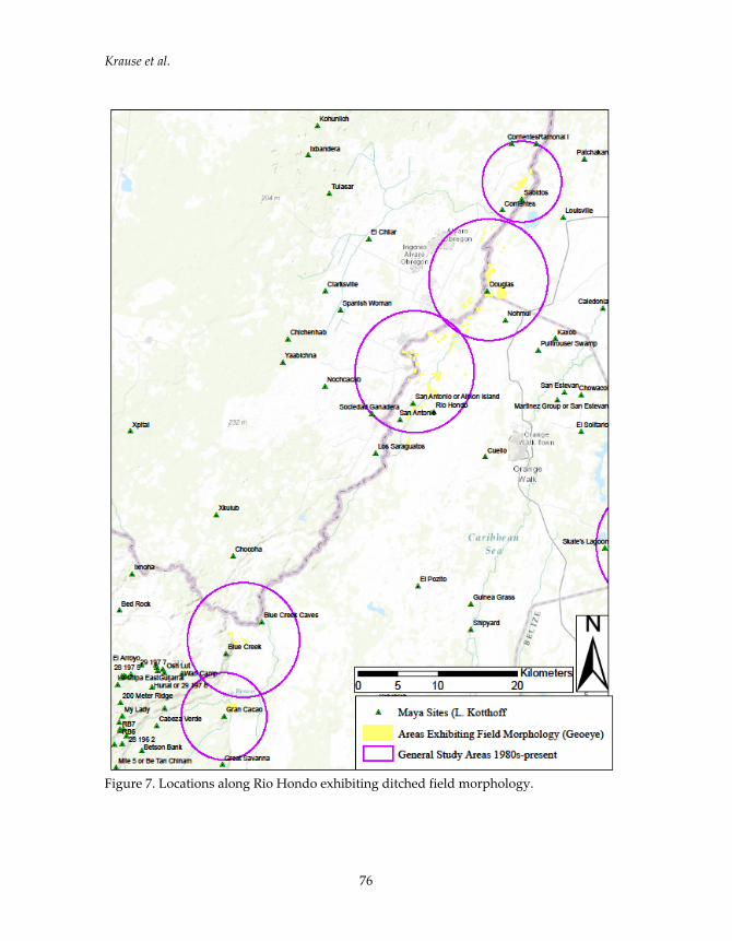
Krause et al.
Figure 7. Locations along Rio Hondo exhibiting ditched field morphology.
76
Sixty Years of Remote Sensing
REFERENCES CITED Adams, R., Brown, W., and Culbert, T. 1981 Radar Mapping, Archeology, and Ancient Maya Land Use. Science
213(4515):1457‐1468. Adams, R., Culbert, T., Brown, W. Harrison P., Levi, L., and Banks, T. 1990 News and Short Contributions. Journal of Field Archaeology, 17(2):241‐244. Anselmetti, F., Hodell, D., Ariztegui, D., Brenner, M., and Rosenmeier, M. 2007 Quantification of Soil Erosion Rates Related to Ancient Maya
Deforestation. Geology 35(10):915. Beach, Timothy P., Sheryl Luzzadder‐Beach, Nicholas Dunning, John G. Jones,
Jon Lohse, Thomas H. Guderjan, Steve Bozarth, Sarah Millspaugh, and Tripti Bhattacharya
2009 A Review of Human and Natural Changes in Maya Lowlands Wetlands over the Holocene. Quaternary Science Reviews 28(17‐18):1710‐1724.
Beach, Timothy, Sheryl Luzzadder‐Beach, Nicholas Dunning, Richard Terry,
Stephen Houston, and Thomas Garrison 2011 Carbon Isotopic Ratios of Wetland and Terrace Soil Sequences in The
Maya Lowlands Of Belize And Guatemala. CATENA 85(2):109‐118. Beach, Timothy, Sheryl Luzzadder‐Beach, Thomas Guderjan, and Samantha
Krause 2015a The Floating Gardens of Chan Cahal: Soils, Water, and Human
Interactions. CATENA. 132:151‐164. Beach, Timothy, Sheryl Luzzadder‐Beach, Samantha Krause, Stanley Walling,
Nicholas Dunning, Jonathan Flood, Thomas Guderjan and Fred Valdez 2015b ʹMayaceneʹ Floodplain and Wetland Formation in the Rio Bravo
Watershed of Northwestern Belize. The Holocene 25(10):16121626. Coe, Mihcael D. 1964 The Chinampas of Mexico. Scientific American 211:90‐98.
77

Krause et al.
Denevan, W.M. 1970 Aboriginal Drained‐Field Cultivation in the Americas. Science 169:647‐
654. Dunning, Nicholas P. and Timothy Beach 2000 Stability and Instability in Prehispanic Maya Landscapes. In An Imperfect
Balance: Landscape Transformations in the Pre‐Columbian Americas, edited by David Lentz, pp. 179–202. Columbia, New York.
Dunning, Nicholas P., Carmen McCane, Tyler Swinney, Matthew Purtill, Jani
Sparks, Ashley Mann, Jon‐Paul McCool and Chantal Ivenso 2015 Geoarchaeological Investigations in Mesoamerica Move into the 21st
Century: A Review. Geoarchaeology, 30: 167‐199 Fedick, Scott S. 1996 The Managed Mosaic. Salt Lake City: University of Utah Press. Guderjan, Thomas H. 2007 The Nature of an Ancient Maya City: Resources, Interaction, and Power at Blue
Creek, Belize. University Alabama Press Guderjan, Thomas and Samantha Krause 2011 Identifying the Extent of Ancient Maya Ditched Field Systems in the Rio
Hondo Valley of Belize and Mexico: A Pilot Study and Some of its Implcations. Research Reports in Belizean Archaeology. 8:127‐136
Harrison‐Buck, Eleanor, Adam Kaeding and Saturo Murata 2013 A Network of Waterways in the Eastern Belize Watershed: Recent
Survey and Excavation of the 2012 BREA Field Season. Research Reports in Belizean Archaeology 10:77‐90.
Harrison‐Buck, Eleanor, Marieka Brouwer Burg, Mark Willis, Chet Walker,
Satoru Murata, Brett Houk, Alex Gantos, and Astrid Runggaldier 2015 Drones, Mapping, and Excavations in the Middle Belize Valley: Research
Investigations of the Belize River East Archaeology (BREA) Project. Research Reports in Belizean Archaeology 12:295‐304.
78
Sixty Years of Remote Sensing
Jacob, John S. 1996 Ancient Maya Wetland Agricultural Fields in Cobweb Swamp, Belize:
Construction, Chronology, and Function. Journal of Field Archaeology, 22(2), 175.
Kauth, R.J. and Thomas, G.S. 1976 The Tasselled Cap ‐‐ A Graphic Description of the Spectral‐Temporal
Development of Agricultural Crops as Seen by LANDSAT. Proceedings on the U.S. Department of the Interior. West Lafayette, Indiana: LARS, Purdue University, 41‐51.
Lasaponara, Rosa and Nicola Masini 2006 Identification of Archaeological Buried Remains Based on the
Normalized Difference Vegetation Index (NDVI) from Quickbird Satellite Data. IEEE Geoscience Remote Sensing Lett., 3(3):325‐328.
Lemonnier, Eva and Boris Vannière 2013 Agrarian Features, Farmsteads, and Homesteads in the Rio Bec Nuclear
Zone, Mexico. Ancient Mesoamerica 24(02):397‐413. Luzzadder‐Beach, Sheryl, Timothy Beach and Nicholas Dunning 2012 Wetland Fields as Mirrors of Drought and the Maya Abandonment.
Proceedings of the National Academy of Sciences 109(10):3646‐3651. Nondédéo, Philippe, M. Charlotte Arnauld, Dominique Michelet 2013 Rio Bec Settlement Patterns and Local Sociopolitical Organization.
Ancient Mesoamerica 24(2):373‐396. Parcak, Sarah H. 2009 Satellite Remote Sensing for Archaeology. Routledge, London. Pohl, Mary 1990 Ancient Maya Wetland Agriculture: Excavations On Albion Island, Northern
Belize. Westview Press, Boulder, Colorado. Pyburn, K. Anne 2003 The Hydrology of Chau Hiix. Ancient Mesoamerica, 14(01):123‐129.
79

Krause et al.
Schowengerdt, Robert 2007 Remote Sensing. Academic Press, Burlington, MA:. Siemens, Alfred H. and Dennis E. Puleston 1972 Ridged Fields and Associated Features in Southern Campeche. American
Antiquity 37(2):228‐239. Turner, B.L., II 1976 Population Density in the Classic Maya Lowlands: New Evidence for
Old Approaches. Geographical Review 66(1): 73. Turner, B.L., II and Peter D. Harrison 1981 Prehistoric Raised‐Field Agriculture in the Maya Lowlands. Science
213(4506):399‐405. Wahl, D., Byrne, R., and Anderson, L. 2014 An 8700 year paleoclimate reconstruction from the southern Maya
lowlands. Quaternary Science Reviews, 103:19–25. Watts, Adam C., Danielle L. Watts, Matthew J. Cohen, James B. Heffernan,
Daniel L. McLaughlin, Jonathan B. Martin, David A. Kaplan, Todd Z. Osborne, and Leda N. Kobziar.
2014 Evidence for Biogeomorphic Patterning in a Low‐Relief Karst Landscape. Earth Surface Processes and Landforms 39(15):2027–2037.
80

81
TO THE FOUR WINDS – COMMUNAL IDENTITIES AND
DESTINIES ON NEW SPAIN’S FAR NORTHERN FRONTIER:
THE PIRO AND TIWA PROVINCES OF NEW MEXICO, CA. 1540-1740
Michael P. Bletzer, Jornada Resesarch Institue, Tularosa, NM
INTRODUCTION
The processes and consequences of Spanish colonization across the northern
frontiers of the viceroyalty of New Spain have long been subject to extensive
historical research. For almost a century now, the term “Spanish Borderlands”
has come to epitomize the development of the Spanish frontier in North
America, the history of its structural and geopolitical context, as well as the
dynamics of native-Spanish relations on both local and regional levels (Sandos
1994; e.g. Bolton 1921; Bannon 1974; Weber 1992, 2005; Lawrence and Lawrence
2016). This tradition of research, which has been accompanied to a certain extent
by similar efforts in the field of archaeology (e.g. Thomas 1989-1991; Baker and
Kealhofer 1996; Panich and Schneider 2014), has generated a large body of local
and regional studies, but owing to the scale and complexity of the subject matter
many aspects of the native-Spanish encounter remain obscure (Thomas 2012;
Ivey and Thomas 2005; Pauketat 2008).
In New Mexico, which formed the outermost frontier of New Spain in the contact
period (1540-1598) and early colonial period (1598-1680) up to the years of the
Pueblo Revolt and Spanish reoccupation (1680-1700) (Figure 1), one key aspect
still imperfectly understood is the Pueblo settlement landscape during those
years. The overall trajectory of post-contact population loss, settlement shifts,
and regional abandonment seems clear enough (Schroeder 1979), but not so the
processes driving patterns of communal persistence, disintegration, and
consolidation/(re)formation. In the case of the Pueblos, the surviving records of
what Spaniards saw (or thought they saw) in their dealings with individual
communities or what they tended to call naciones (groups of pueblos within the
same language group) provide some intriguing glimpses of demographic
processes, yet the information is limited and fragmented. Still, period documents
generally show that the popular image of spatially deep-rooted Pueblos today
which to the casual observer may suggest long-term stability and permanence is
misleading, and that by the early 1700s the Pueblo settlement landscape was
vastly different from that of the late 1500s. Beyond this, Pueblo oral traditions
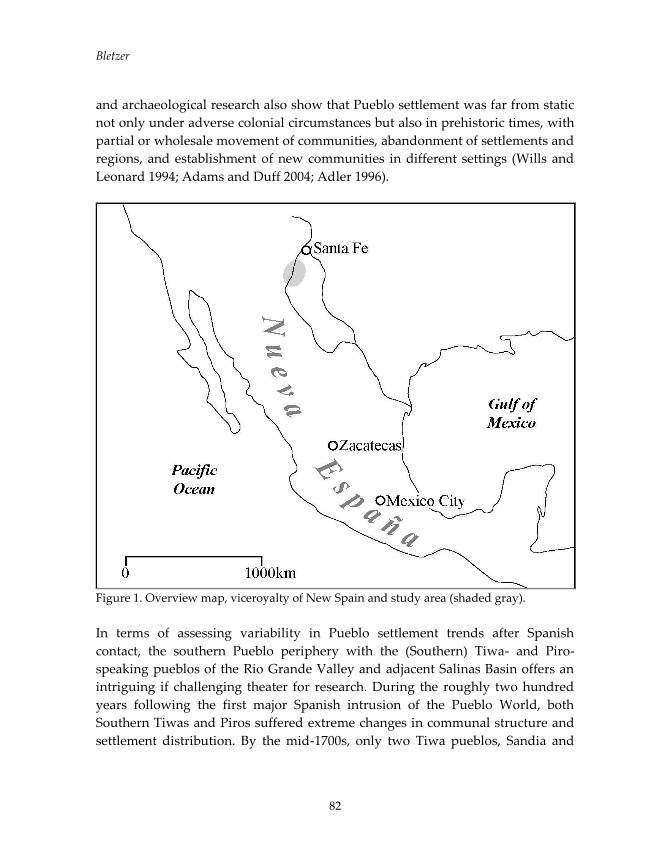
Bletzer
82
and archaeological research also show that Pueblo settlement was far from static
not only under adverse colonial circumstances but also in prehistoric times, with
partial or wholesale movement of communities, abandonment of settlements and
regions, and establishment of new communities in different settings (Wills and
Leonard 1994; Adams and Duff 2004; Adler 1996).
Figure 1. Overview map, viceroyalty of New Spain and study area (shaded gray).
In terms of assessing variability in Pueblo settlement trends after Spanish
contact, the southern Pueblo periphery with the (Southern) Tiwa- and Piro-
speaking pueblos of the Rio Grande Valley and adjacent Salinas Basin offers an
intriguing if challenging theater for research. During the roughly two hundred
years following the first major Spanish intrusion of the Pueblo World, both
Southern Tiwas and Piros suffered extreme changes in communal structure and
settlement distribution. By the mid-1700s, only two Tiwa pueblos, Sandia and
To The Four Winds
83
Isleta, were still (or rather again) in existence in the Ancestral Southern Tiwa
homeland in the Rio Grande Valley around Albuquerque and along the east
slope of the Manzano Mountains (Figure 2). A third pueblo, Ysleta del Sur
southeast of El Paso, was formed with Tiwas mainly from Isleta, taken captive in
1681, a year after the Pueblo Revolt, in a failed Spanish campaign of reconquest
(Schroeder 1979; Houser 1979). The Tiwas’ neighbors to the south fared even
worse. By 1700, not even one of the pueblos the Piros had inhabited a century
earlier was left. The Salinas Piro (or Tompiro) pueblos were abandoned during a
period of severe drought in the 1670s and the surviving residents resettled with
their Rio Grande Piro cousins. In the wake of the Pueblo Revolt of 1680, however,
the Rio Grande Piro pueblos themselves were abandoned. Several hundred Piros
were taken by the Spaniards to El Paso in 1680 and 1681. These Piros also ended
up southeast of El Paso in two new pueblos, named Socorro and Senecú after
their pre-Revolt precursors. An unknown but apparently significant number of
Piros managed to evade removal and joined communities from Zuni and Acoma
in the west to the Jemez, Keres, and Tewa pueblos on the northern Rio Grande.
The Ancestral Piro pueblos were never resettled (Schroeder 1979; Bletzer 2013,
2015; Marshall and Walt 1984).
COMMUNAL DESTINIES IN THE TIWA AND PIRO AREAS: HISTORICAL
OUTLINE
For the Southern Tiwas, initial contacts with the Spaniards were disastrous. In
late 1540, the demands of the Coronado expedition turned into all-out warfare
when the Spaniards attacked and besieged several Rio Grande Tiwa pueblos.
Hundreds of Tiwas were killed and at least two pueblos completely destroyed.
At one point most (if not all) Tiwa pueblos were abandoned, their residents
fleeing before the Spanish onslaught (Flint and Flint 2005; Lawrence and
Lawrence 2016). Coronado’s force left behind traumatized and displaced
communities, but when Spanish expeditions made it back to the Rio Grande in
the early 1580s they reported a number of extant pueblos along the same stretch
of river devastated forty years earlier (Schroeder 1979; Marshall 1985; Snow 1988;
Chapman 2015). Also dating from the 1580s are the first clear references to the
Tiwa pueblos east of the Manzano Mountains. Spanish colonization after 1598
brought these pueblos into focus due to their location near several salt lakes and
on a frontier visited by groups of mobile hunters from the Plains. The
seventeenth-century jurisdicción or alcaldía mayor of Las Salinas included these

Bletzer
84
Tiwa communities, as well as several Piro-speaking pueblos to the south and east
(Schroeder 1979; Baldwin 1988; Bletzer 2013, 2015).
Figure 2. The Southern Tiwa and Piro provinces post-1700.

To The Four Winds
85
In many pueblos the most permanent and socially intrusive manifestation of the
new colonial regime was the Franciscan mission. Among the southern Pueblos
the missionaries generally worked north to south: the Tiwa pueblos on the Rio
Grande from Sandia to Isleta in the 1610s, those in Las Salinas from Chililí to
Quarai from the 1610s to the late 1620s, the Rio Grande Piro pueblos from
Sevilleta to Senecú in the mid-1620s to early 1630s, and the Salinas Piro pueblos
from Abó to Tabira in the early 1620s to 1630s (Fig. 3) Some missions were
permanent administrative centers (doctrinas or cabeceras) in charge of outlying
missions (visitas) staffed by trained native personnel and visited at intervals by
priests from the nearest cabecera (Schroeder 1979; Ivey 1988; Bletzer 2011, 2013).
Communities without either cabecera or visita status could be subject to removal
to a mission pueblo under the policy of reducción or congregación. Widely carried
out by civil and religious authorities elsewhere in New Spain (Gerhard 1977;
Quezada 1995), reducciones of pueblos also occurred in seventeenth-century New
Mexico, including reportedly the Tiwa (Chililí) and Piro (Tzelaqui/Sevilleta)
areas. Surviving documents, however, contain few details regarding scale,
timing, and execution of this supervised settlement consolidation, nor delimit the
range of possible responses (rejection, accommodation, factionalism, resistance,
etc.) on the part of communities subjected to this process (e.g. Elliott 2002; Bletzer
2011).
Even basic occupation sequences of mission pueblos are vague. Administrative
files like mission registers (baptisms, marriages, burials) or tributary lists do not
exist for the pre-Pueblo Revolt period. How long (and to what extent) individual
pueblos may have been occupied into the colonial period can only be assessed
through more or less random references in a variety of records and accounts.
Population figures are even more sporadic and inconsistent. Paleoclimatological
records and theories on disease transfer corroborate the overall image emerging
from Spanish sources of worsening living conditions and declining populations
especially after 1650, but the nature of the data is still inadequate to track
communities in any detail (Schroeder 1979; Preucel 2002; Ivey and Thomas 2005;
Marshall 1985; Marshall and Walt 1984; Bletzer 2009, 2013).

Bletzer
86
Figure 3. Southern Tiwa and Piro mission pueblos.
Tiwa settlement history from early colonial times through the mission and
Pueblo Revolt periods into the mid-1700s is clear only in broad outline. In 1598,
fray Juan Claros received, among other areas, la probincia de los chiguas o tiguas
and his confrère fray Francisco de San Miguel los pueblos de la gran salina que cae

To The Four Winds
87
tras la sierra del Puaray. Between them, the two regions may have had between
fifteen and twenty Tiwa pueblos (Archivo General de Indias [AGI], Patronato,
legajo 22, ff. 1000v-1001r). Those initial mission assignments were short-lived,
however, and later records never again mention a like number of pueblos by
name, only those of cabecera or visita status. Tiwa pueblos with either status in the
1600s included Sandia, Puaray, Alameda, and Isleta on the Rio Grande, and
Chililí, Tajique, and Quarai in Las Salinas (Figure 3). Although the identities of
pueblos mentioned in the documents are not always clear, the latter three
pueblos were largely abandoned in the 1670s. For their part, the Rio Grande
Tiwa pueblos were temporarily abandoned and partly damaged during the
Pueblo Revolt (Figure 4). The Spanish capture at Isleta in late 1681 of several
hundred Tiwas and Piros resulted in their removal to El Paso (Schroeder 1979;
Ellis 1979). After the Spanish reconquest of the 1690s, the Tiwa pueblos remained
abandoned, except for a small reoccupation of Alameda around 1700. In 1748,
Sandia (native name Naphíˀad, “at the dusty place”) was finally resettled by Tiwa
refugees brought back from Hopi country, Hopis, and possibly a mix of refugees
from other groups (Keres? Jemez?). Isleta (native name Šiehwíb-àg “flint kick-stick
place”) may have been reoccupied a few years before Sandia, also by Tiwa and
other refugees (Brandt 1979; Ellis 1979; Schroeder 1979; Marshall 1985; Snow
2012).
The Piro pueblos were first described in the early 1580s by Spanish explorers
who noted some sixteen to twenty larger pueblos along the Rio Grande and
adjacent uplands. Early colonial documents identify the Piro area as the
“province” of the Atzigues (or Tziguis), a Hispanicized form of the ethnonym
A’tzi-em (“[the] people”), recorded in the nineteenth century and still in use
among Piro descendants today. Like the Tiwa pueblos, missionization of the Rio
Grande and Salinas Piros was initially assigned to frays Juan Claros and
Francisco de San Miguel. The assignments suggest that some two dozen Piro
pueblos were then in existence (AGI, Patronato, legajo 22, ff. 1000v-1001r). The
first mission at a Piro pueblo was not established until 1622 at Abó, after which
the process accelerated in the mid-1620s with missions at the Rio Grande pueblos
of Pilabó/Socorro, Senecú, and Tzelaqui/Sevilleta; in Las Salinas at Las Humanas
(1629), perhaps Tenabó (1630s?), Tabira (ca. 1630); and the Rio Grande Piro
pueblo of Alamillo (early 1630s) (Figure 3) (Schroeder 1979; Hayes at el. 1979;
Ivey 1988; Bletzer 2011, 2013).

Bletzer
88
As in the case of the Tiwa pueblos, later colonial records for the Piro area indicate
that Piro settlement contracted in adverse conditions brought on by drought and
disease. In addition, armed resistance to Spanish domination (Abó and Las
Humanas 1599-1602, Abó and Tenabó 1610s-1622; Senecú and Socorro 1660s;
Abó and Las Salinas generally late 1660s and early 1670s) severely impacted
several Piro communities (Hickerson 1996; Bletzer 2015). Starting in 1671, the
Salinas Piro pueblos were abandoned and the surviving residents moved to the
Rio Grande pueblos, especially Socorro and Senecú. In August 1680 the Piros of
Socorro planned to join in the Pueblo Revolt by attacking the retreating Spanish
colonists encamped near the pueblo. The plan failed, however, and more than
three hundred Piros were removed to the El Paso area, where they were joined
the following year by three hundred more captured at Isleta during the first
Spanish attempt to reconquer New Mexico. The Pueblo Revolt marked the end
for all Ancestral Piro pueblos (Figures 2, 4) (Schroeder 1979; Bletzer 2013, 2015).
COMMUNAL DESTINIES IN THE TIWA AND PIRO AREAS:
ARCHAEOLOGICAL PERSPECTIVES
However fragmented the historical record of communal destinies in the Tiwa
and Piro regions may be, it still reflects something of the variability of the
processes shaping these destinies. Social dynamics affecting differential
persistence of pueblos include internal and external factors, such as pueblo
organization and degree(s) of factionalism and the policy of reducción, for
instance (Figure 5). Some documents reveal that Spanish interference in internal
affairs intensified existing tensions within what appear to have been traditionally
heterogeneous pueblos (Pauketat 2008). Relocation of whole or partial
communities especially as part of reducciones further undermined communal
coherence by placing “outsiders” in mission pueblos (cf. Snow 2012; Preucel
2002). As external pressures increased during the later 1600s, quite a few pueblos
disintegrated, never to reform as spatially unified communities.

To The Four Winds
89
Figure 4. Southern Tiwa and Piro pueblos, ca. 1670-1680.

Bletzer
90
Figure 5. Schematic overview of pre-contact to post-Pueblo Revolt community dynamics.
To The Four Winds
91
Archaeologically, such movements and processes may be reflected in (or at least
suggested by) occupation sequences, abandonment and possible reoccupation
deposits, and spatial dislocation of colonial-period structures. In the Tiwa region,
the emphasis of research presently rests on the violent episodes of the Coronado
expedition and the initial phase of missionization at the pueblo of Isleta (Poling
2015; Schmader 2015; Michael P. Marshall, personal communication 2016). The
case-specific nature of these projects and particular circumstances of site
preservation translate into tight foci on certain events and relatively short time
periods (cf. Eckert and Cordell 2002). For the Rio Grande Piro area, however,
there is a growing database of structural and depositional data from long-term
projects at two large sites. The first site is likely that of Teypana, mentioned
repeatedly in documents from the early colonial period and doubtless one of
fourteen unnamed Rio Grande Piro pueblos still noted as occupied in the late
1620s (Figures 2, 6). Unlike at most sites in the area, the wide occurrence at
Teypana of sixteenth- and early seventeenth-century glazeware ceramics and a
lack of earlier types indicates no decrease in occupied space through time. Even
more striking is a scarcity of objects considered valuable/useful to a Piro
household: decorated ceramic vessels, items of adornment or ritual use, intact
metates, and remains of load-carrying roof timbers or vigas. Several rooms
contained pieces of smaller poles and grass matting from collapsed roofs, which
shows that the absence of vigas cannot be ascribed to decay. Removal of metates
and vigas has been documented at many Pueblo sites and is considered evidence
of planned structure abandonment. Ethno-archaeological studies reveal a strong
likelihood of salvage and reuse of such materials in planned, short-distance
relocations (Cameron 1991; Cameron and Tomka 1993). Overall, there is no
evidence that processes other than peri-abandonment salvage and natural
structure decay played a role in the formation of the Teypana site assemblage
(Bletzer 2009, 2011).
To all appearances, then, Teypana’s last residents cleared out their pueblo of
most, if not all, decorated vessels, grinding stones, and roof beams. Ethno-
archaeological data linking specific material patterns to specific kinds of
abandonment behavior show that such patterns differ in relation to factors like
planning, anticipation of return, distance of move, and absolute/relative
properties of movable items. Abandonment that is planned, final, and involves
only a short-distance move will leave few items of use/value at the abandoned
place (Stevenson 1982, 1985; Schiffer 1996; Cameron 1991; Cameron and Tomka

Bletzer
92
1993). All chronological data indicate that Teypana was occupied not long into
the period when the mission at Pilabó/Socorro, located barely five kilometers to
the north was established. This proximity to what was to become the “principal”
Piro mission would have made Teypana a prime candidate for a reducción,
especially in times of population attrition. In view of this context, the only
plausible destination or recipient community for Teypana’s residents would
have been the Socorro mission pueblo, close enough not only to facilitate
removal of objects such as metates, but also return visits to salvage usable
construction materials such as roofing timbers (Bletzer 2009, 2011).
Figure 6. Project map, Teypana Pueblo.

To The Four Winds
93
The second site is Tzelagui/Sevilleta, a pueblo reconstituted as a mission pueblo
around 1627/28 after a brief period of abandonment (Figures 3, 7). For most of its
life, the Sevilleta mission was a visita of the Socorro mission, which functioned as
regional cabecera. Spanish documents hint at a confused occupation history for
Sevilleta from ca. 1600 to 1681, including the pueblo’s role as recipient for
immigrants from other pueblos (unfortunately nowhere named).
Tzelaqui/Sevilleta is the only historically referenced recipient pueblo in a
reducción process in the Piro area and one of only three Piro pueblos for which a
relatively detailed documentary context exists. Subjected to archaeological
testing and documentation since 2014, Sevilleta has already produced a
significant amount of data relating to its occupation history, as a result of which
a number of assumptions and structural identifications based on surface
observations had to be modified (cf. Marshall and Walt 1984). Most importantly,
the structural mound previously identified as the remains of the mission from
1627/28 has been shown to be an isolated room block that may well represent the
last major domestic construction episode at the pueblo. Yielding only
seventeenth-century glazewares and contemporary trade/foreign ceramics (e.g.
San Luis Blue-on-white majolica, Tewa Polychrome, Salinas red wares; Tabira
white wares) as well as iron artifacts and bones of introduced domestic animals
(sheep/goat, cow), this room block stands in sharp contrast to the bulk of the
pueblo, which has a sizeable early glazeware presence underlying later ceramics.
As tested so far, layouts and features of rooms in this room block largely conform
to rooms documented at Teypana Pueblo, but there are also some Spanish
structural elements (such as a plugged low-threshold doorway almost exactly
one Castilian vara wide). The mix of artifacts, architecture, and spatial separation
points to this room block as possible accommodation for the “outsiders” known
to have been brought into the pueblo in the wake of the mission founding of the
late 1620s (Bletzer 2015; cf. Snow 2012).
By way of brief conclusion, then, recent and ongoing archaeological research
especially in Rio Grande Piro area is throwing some new light on developments
in diverse Pueblo communities in the years after Spanish colonization. The
fortuitous identification of a rare, largely preserved, likely reducción donor
settlement and the possibility of studying an early seventeenth-century
mission/visita settlement in its entirety have produced data sets amenable to
assessing the possible variability of post-contact settlement trends and thus the
destinies of different communities otherwise unrecorded by Spanish observers.
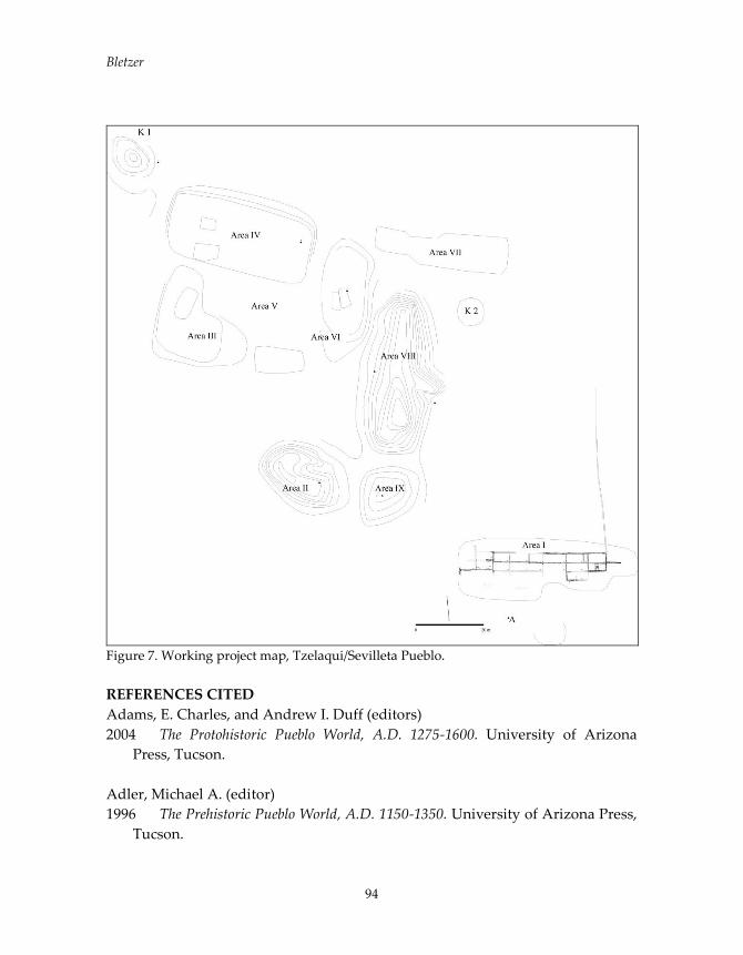
Bletzer
94
Figure 7. Working project map, Tzelaqui/Sevilleta Pueblo.
REFERENCES CITED
Adams, E. Charles, and Andrew I. Duff (editors)
2004 The Protohistoric Pueblo World, A.D. 1275-1600. University of Arizona
Press, Tucson.
Adler, Michael A. (editor)
1996 The Prehistoric Pueblo World, A.D. 1150-1350. University of Arizona Press,
Tucson.
To The Four Winds
95
Baker, Brenda J., and Lisa Kealhofer (editors)
1996 Bioarchaeology of Native American Adaptation in the Spanish Borderlands.
University Press of Florida, Gainesville.
Baldwin, Stuart J.
1988 Tompiro Culture, Subsistence and Trade. Ph.D. dissertation, Department of
Anthropology, University of Calgary, Calgary.
Bannon, John F.
1974 The Spanish Borderlands Frontier, 1513-1821. University of New Mexico
Press, Albuquerque.
Bletzer, Michael
2009 Pueblos Without Names: A Case Study of Piro Settlement in Early Colonial
New Mexico. Ph.D. dissertation, Department of Anthropology, Southern
Methodist University, Dallas. University Microfilms, Ann Arbor.
2011 A Church in Every Town: Early Colonial Settlement Dynamics on the Southern
Pueblo Frontier. Paper presented at the 2011 Society for Historical
Archaeology Conference on Historical and Underwater Archaeology, Austin,
TX.
2013 The First Province of That Kingdom: Notes on the Colonial History of
the Piro Area. New Mexico Historical Review 88(4): 437-459.
2015 Road to Nowhere: Contact, Colonization, and the Demise of the Piro
Province, 1581-1681. In Diversity in the Jornada Mogollon Region: Proceedings
from the 18th Jornada Mogollon Conference, edited by George O. Maloof and
Brittany M. Hutchinson, pp.133-161. El Paso Museum of Archaeology, El
Paso, TX.
Bolton, Herbert E.
1921 The Spanish Borderlands: A Chronicle of Old Florida and the Southwest. Yale
University Press, New Haven.
Brandt, Elizabeth A.
1979 Sandia Pueblo. In Southwest, edited by Alfonso Ortíz, pp. 343-350.
Handbook of North American Indians, Vol. 9. William C. Sturtevant, general
editor, Smithsonian Institution, Washington, D.C.
Bletzer
96
Chapman, Richard C.
2013 Sixteenth-Century Indigenous Settlement Dynamics in the Upper Middle
Rio Grande Valley. In Native and Spanish New Worlds: Sixteenth-Century
Entradas in the American Southwest and Southeast, edited by Clay Mathers,
Jeffrey M. Mitchem, and Charles M. Haecker, pp. 155-169. University of
Arizona Press, Tucson.
Eckert, Suzanne L., and Linda S. Cordell
2004 Pueblo IV Community Formation in the Central Rio Grande Valley: the
Albuquerque, Cochiti, and Lower Rio Puerco Districts. In The Protohistoric
Pueblo World, A.D. 1275-1600, edited by E. Charles Adams and Andrew I.
Duff, pp. 35-42. University of Arizona Press, Tucson.
Elliott, Michael L.
2002 Mission and Mesa: Some Thoughts on the Archaeology of Pueblo Revolt
Era Sites in the Jemez Region, New Mexico. In Archaeologies of the Pueblo
Revolt: Identity, Meaning, and Renewal in the Pueblo World, edited by Robert W.
Preucel, pp. 45-60. University of New Mexico Press, Albuquerque.
Ellis, Florence Hawley
1979 Isleta Pueblo. In Southwest, edited by Alfonso Ortíz, pp. 351--365.
Handbook of North American Indians, Vol. 9. William C. Sturtevant, general
editor, Smithsonian Institution, Washington, D.C.
Flint, Richard, and Shirley Cushing Flint (editors)
2005 Documents of the Coronado Expedition, 1539-1542. University of New
Mexico Press, Albuquerque.
Gerhard, Peter
1977 Congregaciones de indios en la Nueva España antes de 1570. Historia
Mexicana 103: 347-395
Franklin, Hayward H.
2010 The Pottery of Jaral Pueblo (LA 47875), a PIV Settlement in the Foothills
of the Sandia Mountains. Pottery Southwest 29(3): 2-17.

To The Four Winds
97
Hayes, Alden C., Jon N. Young, and A.H. Warren
1981 Excavation of Mound 7, Gran Quivira National Monument, New Mexico.
Publications in Archeology No. 16. National Park Service, Washington, D.C.
Hickerson, Nancy P.
1996 The Servicios of Vicente de Zaldívar: New Light on the Jumano War of
1601. Ethnohistory 43(1): 127-144.
Houser, Nicholas P.
1979 Tigua Pueblo. In Southwest, edited by Alfonso Ortíz, pp. 336-342.
Handbook of North American Indians, Vol. 9. William C. Sturtevant, general
editor, Smithsonian Institution, Washington, D.C.
Ivey, James E.
1988 In the Midst of a Loneliness: The Architectural History of the Salinas Missions.
Southwest Cultural Resources Center, Professional Paper No. 15. National
Park Service, Santa Fe.
Ivey, James E., and David H. Thomas
2005 “The Feeling of Working Completely in the Dark.” The Uncertain
Foundations of Southwestern Mission Archaeology. In Southwest Archaeology
in the Twentieth Century, edited by Linda S. Cordell and Don D. Fowler, pp.
204-219. University of Utah Press, Salt Lake City.
Lawrence, Deborah, and John Lawrence
2016 Contesting the Borderlands: Interviews on the Early Southwest. University of
Oklahoma Press, Norman.
Lekson, S.H., M. Bletzer, and A.C. MacWilliams
2004 Pueblo IV in the Chihuahuan Desert. In The Protohistoric Pueblo World,
A.D. 1275-1600, edited by E. Charles Adams and Andrew I. Duff, pp. 53-61.
University of Arizona Press, Tucson.
Lycett, Mark T.
2002 Transformations of Place: Occupational History and Differential
Persistence in Seventeenth-Century New Mexico. In Archaeologies of the
Bletzer
98
Pueblo Revolt: Identity, Meaning, and Renewal in the Pueblo World, edited by
Robert W. Preucel, pp. 61-74. University of New Mexico Press, Albuquerque.
Marshall, Michael P.
1985 Archaeological Investigations in the Rio Medio District. Records and ms. on
file, New Mexico State Historic Preservation Division, Santa Fe.
Marshall, Michael P., and Henry J. Walt
1984 Rio Abajo: Prehistory and History of a Rio Grande Province. New Mexico
Historic Preservation Division, Santa Fe.
Panich, Lee M., and Tsim D. Schneider (editors)
2014 Indigenous Landscapes and Spanish Missions: New Perspectives From
Archaeology and Ethnohistory. University of Arizona Press, Tucson.
Pauketat, Timothy R.
2008 The Grounds for Agency in Southwest Archaeology. In The Social
Construction of Communities: Agency, Structure, and Identity in the Prehispanic
Southwest, edited by Mark D. Varien and James M. Potter, pp. 233-250.
Altamira Press, Walnut Creek, CA.
Poling, Charles C.
2015 The Search for Moho. American Archaeology 19(1): 39-45.
Preucel, Robert W. (editor)
2002 Archaeologies of the Pueblo Revolt: Identity, Meaning, and Renewal in the
Pueblo World. University of New Mexico Press, Albuquerque.
Quezada, Noemi
1995 Congregaciones de indios y grupos étnicos: el caso del Valle de Toluca y
zonas aledañas. Revista Complutense de Historia de América 21: 141-166.
Sandos, James H.
1994 From “Boltonlands” to “Weberlands,” the Borderlands Enter American
History. American Quarterly 46: 595-604.

To The Four Winds
99
Schmader, Matthew
2015 “They Had So Many Stones to Hurl”: Evidence of Inter-Indigenous Conflict on
the Vázquez de Coronado Expedition, 1540-1542. Paper presented at the 80th
Annual Meeting of the Society for American Archaeology, San Francisco,
CA.
Schroeder Albert H.
1979 Pueblos Abandoned in Historic Times. In Southwest, edited by Alfonso
Ortíz, pp. 236-254. Handbook of North American Indians, Vol. 9. William C.
Sturtevant, general editor, Smithsonian Institution, Washington, D.C.
Snow, David H.
1988 Initial Entradas and Explorations: 1540-1593. In Historic Overview of North
Central New Mexico, edited by Boyd C. Pratt and David H. Snow, Vol. 1, pp.
79-128 New Mexico Historic Preservation Division, Santa Fe.
2012 Situating “Others”: Historic Pueblo Migrants – Some Implications for the
Archaeological Record. In Glen Canyon, Legislative Struggles, and Contract
Archaeology: Papers in Honor of Carol J. Condie, edited by Emily J. Brown, Carol
J. Condie, and Helen K. Crotty, pp. 139-151. Papers of the Archaeological
Society of New Mexico 38. Archaeological Society of New Mexico,
Albuquerque.
Thomas, David H.
2012 Historical Archaeology and Native Agency Across the Spanish
Borderlands. In The Oxford Handbook of North American Archaeology, edited by
Timothy R. Pauketat, pp. 39-51. Oxford University Press, Oxford.
Thomas, David H. (editor)
1989-1991 Columbian Consequences. 3 vols. Smithsonian Institution, Washington,
D.C.
Weber, David J.
1992 The Spanish Frontier in North America. Yale University Press, New Haven.
2005 Bárbaros: Spaniards and Their Savages in the Age of Enlightenment. Yale
University Press, New Haven.

Bletzer
100
Wills, W.H., and Robert D. Leonard (editors)
1994 The Ancient Southwestern Community. University of New Mexico Press,
Albuquerque.

CREATING AN INTERDISCIPLINARY MAP OF SOCIAL CHANGE THROUGH GIS AND BIOARCHAEOLOGY
Marc Wolf, Indiana University East
Katherine Miller Wolf, Indiana University East GIS and bioarchaeological analysis, although occupying opposite poles on the spectrum of archaeological inquiry, are complimentary research methodologies. As in azimuth accounting where 359 degrees is followed by 0 or where the 59th and 1st second of the watch hand are as far as mathematically possible from each other yet as close as well, the macro‐scale of the GIS perspective is an iteration of the fine microscopic scale of geochemistry. Both investigations become stronger and more scientifically vigorous because of the other. This paper will touch upon several subjects that are apropos to the general theme of this discussion, provide examples of prior and on‐going work done in the Maya area, and relate those applications to other areas of interest—notably Northwestern Belize and the Rio Bravo/Rio Azul drainage basins. Consciously or not—and thus with varying degrees of elaboration and complexity—all archaeological thought directed to relations within and outside of a particular culture strive to understand the modes and directions of communications, trade, and other connections. These scientists logically follow a Latorian Actor‐Network‐Theory (Latour, 1996, 2005), attempting to link cultural events, traits, and material culture to a network of interaction where archaeological sites become nodes in a web of exchange. In “Chronicles of the Maya Kings and Queens” Grube and Martin (2000:25) provide a graphic (Figure 1) that reflects these linkages and relevant Maya archaeological centers with a strict lens of epigraphy, linguistics, and iconography; we would like to show this complex of connections for Northwestern Belize based not only in linguistics and stylistic affinities, but also with the basic building blocks of human biology and basic spatial instincts of the individual and culture in question.
101

Wolf and Wolf
Figure 1. In essence, our work aims to combine spatial relations and bioarchaeological affinities under a unified umbrella of GIS technology in the Maya region (Figure 2). The ideas we are attempting to communicate are—at the moment—best exemplified by research conducted at the pre‐eminent Maya archaeological site in Honduras, Copan. We are not necessarily presenting new data or methodologies; we are simply pointing to the potential information and intriguing connections revealed when applying these techniques to the sites within the Three‐Rivers Region of Belize. Though the scale at which the authors’ first approach the subject of biological and cultural relatedness seems to be at odds with each other, many of the philosophical underpinnings behind the research are identical. Both researchers look to models of social organization that focus on the house or residential complex as discussed by Gillespie (2000, 2007) or Hendon (2010)—touching upon Processual archaeological thought like M. Smith’s postulations on neighborhoods and urbanism in Mesoamerica (Smith 2010, 2011; Smith and Novic 2012). Other
102
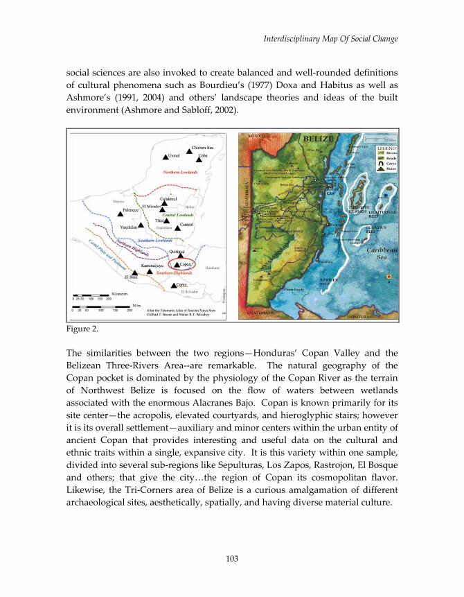
Interdisciplinary Map Of Social Change
social sciences are also invoked to create balanced and well‐rounded definitions of cultural phenomena such as Bourdieu’s (1977) Doxa and Habitus as well as Ashmore’s (1991, 2004) and others’ landscape theories and ideas of the built environment (Ashmore and Sabloff, 2002).
Figure 2. The similarities between the two regions—Honduras’ Copan Valley and the Belizean Three‐Rivers Area‐‐are remarkable. The natural geography of the Copan pocket is dominated by the physiology of the Copan River as the terrain of Northwest Belize is focused on the flow of waters between wetlands associated with the enormous Alacranes Bajo. Copan is known primarily for its site center—the acropolis, elevated courtyards, and hieroglyphic stairs; however it is its overall settlement—auxiliary and minor centers within the urban entity of ancient Copan that provides interesting and useful data on the cultural and ethnic traits within a single, expansive city. It is this variety within one sample, divided into several sub‐regions like Sepulturas, Los Zapos, Rastrojon, El Bosque and others; that give the city…the region of Copan its cosmopolitan flavor. Likewise, the Tri‐Corners area of Belize is a curious amalgamation of different archaeological sites, aesthetically, spatially, and having diverse material culture.
103

Wolf and Wolf
The sample size is likewise compatible. Though the numbers of raw data from Copan with approximately 1200 individuals does not correspond exactly to the smaller sample available at the moment for the relative area of Belize, the figures are comparable on a smaller scale of settlement concentrations within sub‐regions. The sample curated at Blue Creek includes more than 200 burials that have been studied, cataloged, and inventoried by Hannah Plumer (Plumer, forthcoming) who is working on three of the many groups within this area of Belize; proportionally analogous to the Copan collection. The largest component of the sample dates to the Early Classic but extends from the Preclassic through Terminal Classic eras. Given the active excavations that occur each year the skeletal sample will continue to grow. El Cemeterio, Comedero and Ostuman are a few of the clusters within the Copan kingdom that contribute to the total number of burials studied by Miller Wolf (Miller, 2015). Similarly, our area of particular interest in Belize is patterned with many settlement nodes that can be analyzed in isolation but also as related populations illuminating social and biological variation within a larger geographic region. Both the Copan pocket and Northwest Belize are marked by sub‐areas within the overall settlement that is the chaotic hallmark of an urban environment. Tulix Mul—an ancient Maya settlement cluster located outside the Nojolna site center in Northwestern Belize (Figure 3)—provides paradigmatic examples of this cultural and genetic inconsistency and the abundance of these medium‐sized, semi‐autonomous architectural groups. Gail Hammond (Hammond, 2013) relatively recently conducted excavations at Tulix Mul, encountering 12 formal burials, and several ritual burials. She remarked that “Human burials recovered have yielded valuable information about the mortuary practices carried out at Tulix Mul, and have shown that a wide range of people were chosen to be interred beneath the floors of the each of the structures excavated” (Hammond, 2013:423). She does not think that burials represent ancestors and we would point to this being a greater chance for the burials to exhibit patterns—discernable through detailed GIS mapping and testing—of the ebb and flow of migrations rather than simply representative of solely idealized Maya ancestor warship and ritual.
104
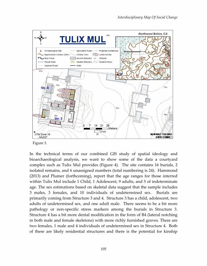
Interdisciplinary Map Of Social Change
Figure 3. In the technical terms of our combined GIS study of spatial ideology and bioarchaeological analysis, we want to show some of the data a courtyard complex such as Tulix Mul provides (Figure 4). The site contains 16 burials, 2 isolated remains, and 6 unassigned numbers (total numbering is 24). Hammond (2013) and Plumer (forthcoming), report that the age ranges for those interred within Tulix Mul include 1 Child, 1 Adolescent, 9 adults, and 5 of indeterminate age. The sex estimations based on skeletal data suggest that the sample includes 3 males, 3 females, and 10 individuals of undetermined sex. Burials are primarily coming from Structure 3 and 4. Structure 3 has a child, adolescent, two adults of undetermined sex, and one adult male. There seems to be a bit more pathology or non‐specific stress markers among the burials in Structure 3. Structure 4 has a bit more dental modification in the form of B4 (lateral notching in both male and female skeletons) with more richly furnished graves. There are two females, 1 male and 4 individuals of undetermined sex in Structure 4. Both of these are likely residential structures and there is the potential for kinship
105

Wolf and Wolf
relationships amongst the individuals interred within their walls. Structure 8 seems a bit unique in that it is an older adult female but other remains were not yet recovered. There is sufficient data within the Tulix Mul complex to begin to aggregate the data to get a sense of the “Tulix Mul” biological signature (based on a cursory assessment of the biodistance data) that could be compared to other regions within the Three‐Rivers Region, such as Blue Creek, Nohal Naj (Figure 5), Bedrock, Xnoha (Figure 6), and many others (Figure 7). Tulix Mul is also a font of information in terms of architecture and other, less obvious spatial attitudes. The site includes numerous vaulted structures, several of which seem to be multi‐story, roomed mini‐palaces. The main plaza is divided into two smaller courtyards by a unique, probably dual‐sided range‐type structure. Buildings appear to be constructed on a hierarchy of basal platforms—another crucial marker of spatial organization. The site lies just meters south of the aforementioned Alacranes Bajo—firmly asserting association with the swamp resources. With the GIS system of seamlessly combining these architectural and burial patterns (and revealing others in the process), discussions of social stratification and cultural identification become undeniably more robust and inclusive. Other indications of cultural identification involve: Body modification is seen in both populations; Copan and in particular Belizean sites under our purview like Noholna (excavated by Gail Hammond, Sam Krause, and Lars Kartoff) where dental modification—even in peripheral and more modest settlement zones‐‐were commonly associated with dental modification, including obsidian inlays. Cranial modification was also an important practice shared by sites in the Maya region and adds more complexity to the cultural and biological signatures of architecture and associated skeletal remains. Material culture and architectural decoration is also emblematic of the identity of persons buried within their home. Facades, stucco masks (Blue Creek Central Precinct, Structure 9 as example), multi‐layered mural painting (Tulix Mul western structures), ancient graffiti (like red‐ochre handprint at Krahnton) ritual artifacts (Axis‐Mundi/jade caches reported by Guderjan), utilitarian goods and more exotic items (like Guatemalan Highland obsidian) are all used to support claims of population origin based upon spatial and skeletal markers—more data for a holistic GIS analysis.
106

Interdisciplinary Map Of Social Change
Figure 4.
107

Wolf and Wolf
Figure 5 One of the archaeological models for this area of Belize is that of a resource gateway to the core of the Maya heartland in Petén of Guatemala. Hierarchies of the discussed Belizean sites have usually culminated in dominance by powerful Petén centers. Logically, resources and finished goods from elsewhere (salt, honey, marine resources—possibly agricultural foodstuffs as postulated by Guderjan, and others). As such, ditched fields and probably other yet unappreciated agricultural land developments lie at center of much of our work. Where we are attempting to identify biological signals behind human remains associated with architectural groups we are also independently linking the spatial preferences of that structural group to particular cultures within the greater region. Skeletal profiles corroborating the GIS structural mapping and isotopes helping to inform categorization of cultural attitudes toward space and building methods, traditions, etc. are logically more powerfully informed than one or the other alone. And the economic foundation of resource exploitation—intensified surplus agriculture—is the most basic way of influencing both biological and architectural affinities. The food is incorporated into the skeleton of the Maya
108

Interdisciplinary Map Of Social Change
builder who modifies the landscape according to their spatial instincts instilled in them through enculturation. Additionally, a vast majority of this population is involved in a system of immigration, transportation, and movement.
Figure 6. In a very Maya cyclical return to the onset of this discussion, we need to reiterate the emphasis on the raw data and the resultant theoretical concepts that arise from the combined power of GIS and bioarchaelogical studies. We have omitted the details of proper archaeological survey and the mechanics of bioarchaeological measurement, as our focal drive behind this presentation is to instill an appreciation of the necessity to apply the techniques to the Northwestern Belize area. One of the key ideas behind this meeting is to scrutinize social constructs within the Maya area; and we would point to the need to know the identity—the context—of the individual members of that society. In our estimation, the best informed views are from those people themselves, and there are few better ways to reach these understandings than
109
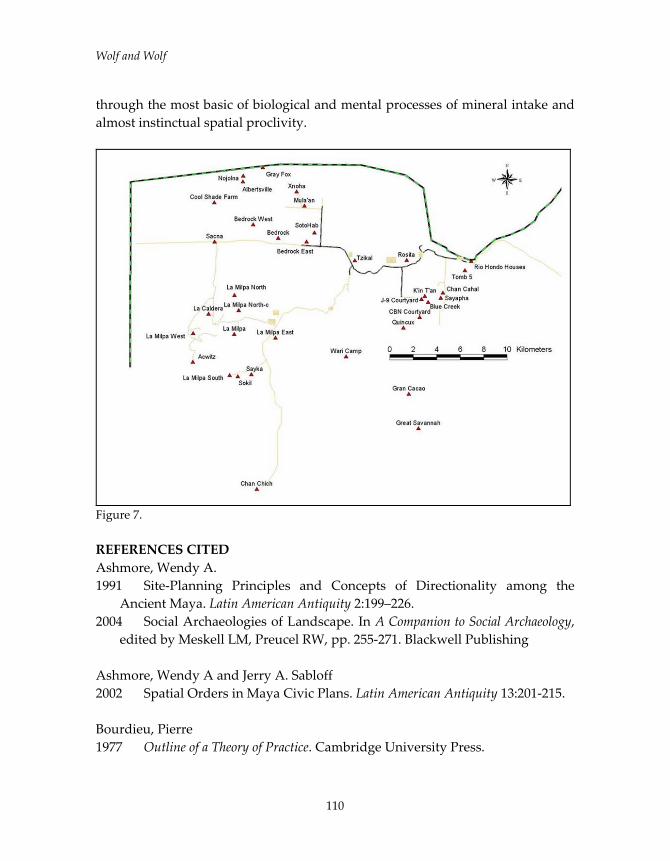
Wolf and Wolf
through the most basic of biological and mental processes of mineral intake and almost instinctual spatial proclivity.
Figure 7. REFERENCES CITED Ashmore, Wendy A. 1991 Site‐Planning Principles and Concepts of Directionality among the
Ancient Maya. Latin American Antiquity 2:199–226. 2004 Social Archaeologies of Landscape. In A Companion to Social Archaeology,
edited by Meskell LM, Preucel RW, pp. 255‐271. Blackwell Publishing Ashmore, Wendy A and Jerry A. Sabloff 2002 Spatial Orders in Maya Civic Plans. Latin American Antiquity 13:201‐215. Bourdieu, Pierre 1977 Outline of a Theory of Practice. Cambridge University Press.
110
Interdisciplinary Map Of Social Change
Gillespie, Susan D. 2000 Rethinking Ancient Maya Social Organization: Replacing “Lineage” with
“House.” American Anthropologist 102:467‐484. 2007 When is a House? In The Durable House: House Society Models in
Archaeology, edited by R.A. Beck, pp. 25‐50. Center for Archaeological Investigations, Occasional Paper No. 35. Southern Illinois University, Carbondale.
Hendon, Julia A. 2010 Houses in a Landscape: Memory and Everyday Life in Mesoamerica. Duke
University Press, Durham. Martin, Simon and Nikolai Grube 2000 Chronicles of the Maya Kings and Queens: Deciphering the Dynasties of the
Ancient Maya. Thames and Hudson, London. Miller, Katherine A. 2015 Family, “Foreigners,” and Fictive Kinship: A Bioarchaeolgoical Approach to
Social Organization at Late Classic Copan. PhD Dissertation, Department of Anthropology, Arizona State University.
Latour, Bruno 1996 On Actor‐Network Theory: A Few Clarifications. Soziale welt (1996):369‐
381. 2005 Reassembling the Social: An Introduction to Actor‐Network‐Theory. Oxford
University Press. Plumer, Hannah Forthcoming PhD Dissertation. University of Sheffield, UK. Smith, Michael E. 2003 Can We Read Cosmology from Maya City Plans? Comment on Ashmore
and Sabloff. Latin American Antiquity 14:221‐228. 2010. Neighborhoods and Districts in Preindustrial Cities. Journal of
Anthropological Archaeology 29:137‐154.
111

Wolf and Wolf
2011 Classic Maya Settlement Clusters as Urban Neighborhoods: A Comparative Perspective on Low‐Density Urbanism. Journal de la Société des Américanistes 97(1):51‐73.
112
113
DID RESTRUCTURING AT THE END OF THE MAYA CLASSIC
PERIOD INCLUDE THE BEGINNINGS OF
PRIVATE LAND TENURE?
Thomas H. Guderjan, Center for Social Sciences Research and Maya Research
Program, University of Texas at Tyler
INTRODUCTION
Temporal transitions in the archaeological record are well-understood to offer
opportunities to better understand what followed them. However, I have also
long argued that such transformations are equally powerful in their ability to aid
us in understanding what came before them. In this paper, I will examine the
meaning of Linear Stone Boundary Markers (LSBMs), also commonly termed “field
walls”, “boundary walls” by archaeologists and “allabrados” by Yucatec Maya
people today and what their presence may mean for how we understand ancient
Maya land tenure both before and after their construction. I will first consider the
non-elite residential group of Chan Cahal, a component of the ancient city of
Blue Creek in northwestern Belize, which does not have LSBMs. Then, I will
summarize the scant but rapidly growing body of information regarding LSBMs.
Finally, I will attempt to contextualize the meaning of LSBMs in the
archaeological record of the ancient Maya and their land tenure systems.
Land tenure – in the absence of relevant epigraphic data- has always been a
difficult to understand subject. “Who owned the land?” is a common question
from interested non-professionals and I have not yet heard a remotely good
response from any of us who study the ancient Maya. That is because such
questions exceed the scope of our current methodologies. One well-known
attempt by Richard Adams and Woodruff Smith (1981) to compare Maya land
tenure to European feudal land systems where land was “owned” by feudal
kings who allowed commoners to live on their land as long as their presence
benefitted the king. This effort met with heavy criticism for attempting to impose
a Euro-centric model on a Maya situation. The take-away message from the
criticism remains that we must develop models of Maya land tenure based on
our data base of the ancient Maya. Interestingly, the converse critique has been
raised about my own studies of Maya cities (Guderjan 2007) with at least one
voice objecting because the city of Blue Creek does not adhere to Euro-centric
views of cities. I continue to argue that models for both urbanization and land
Guderjan
114
tenure can surely come to Maya archaeology from ethnographic analogies for us
to test. However, we will only have a successful model when we have gleaned
what we can from ethnographic analogies, moved past them, and develop truly
Maya-based models of the Maya past. Few investigators have directly focused
on land tenure but have often used the idea of understanding settlement patterns
and cultural landscapes as proxies or building blocks to understand land tenure.
An important exception is Olivier de Montmollin’s studies of the highland
valleys of Chiapas (1989).
However, LSBMs offer a scant but growing data base that our methodologies can
investigate and that can be “windows into the past” that allow us to construct
and test models and hypotheses. I hope this paper is a small step in that
direction.
CHAN CAHAL
Chan Cahal is a well-studied residential group, part of the ancient Maya city of
Blue Creek, that can stand as an example of Classic period communities without
LSBMs and how we approach concepts of land tenure. Blue Creek is a Maya
center located on top of the Bravo Escarpment overlooking the Belize Coastal
Plain. It sits in sight of the confluence of the Rio Azul and Rio Bravo. At the base
of the escarpment below the Blue Creek central precinct are lowlands crossed by
two sacbeob that provided access to and from the base of the escarpment
immediately below the central precinct. Approximately 2 km north-east of the
central precinct at the base of the escarpment is the Chan Cahal residential area
and its related ditched fields.
Chan Cahal consists of at least 50 known structures (Figure 1), most of which
were built of pole and thatch and are known only from small house mounds
without masonry architecture. A set of ditched wetland fields is situated between
the Chan Cahal residential area and the base of the Bravo Escarpment. The
founding dates for houses at Chan Cahal are in the Terminal Preclassic/Early
Classic range, contemporary with initial construction of agricultural ditches
(Beach et al. 2015; Guderjan, et al 2016; Guderjan et al 2017, Van der Notelear
2016b).
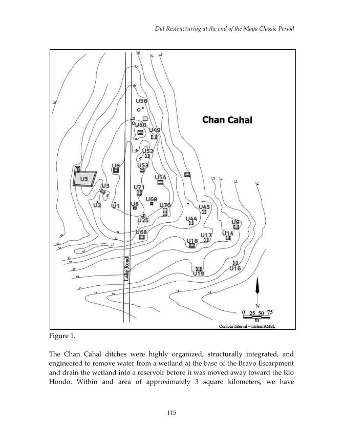
Did Restructuring at the end of the Maya Classic Period
115
Figure 1.
The Chan Cahal ditches were highly organized, structurally integrated, and
engineered to remove water from a wetland at the base of the Bravo Escarpment
and drain the wetland into a reservoir before it was moved away toward the Rio
Hondo. Within and area of approximately 3 square kilometers, we have

Guderjan
116
documented at least 6 linear kilometers of ditches. Excavations show these to
typically be two meters deep and two meters wide, though there is much
variability. These long, linear, interconnected ditches merge to drain water to a
reservoir (Figure 2). The degree of organization and large scale of construction
involved have been interpreted as indicators of centralized control of the fields,
likely by the ahau of Blue Creek, especially in the absence of significant
stratification, the lack of apparent royals or elites, and a likely inadequate labor
force at Chan Cahal.
Figure 2.
So, we believe that the residents of Chan Cahal did not have “ownership” of the
ditched agricultural fields adjacent to their homes.1 They may not have even
“owned” their homes. More than most, the Chan Cahal situation fits Adam’s
feudal model well. The residents were at or near the bottom of the socio-
economic system and began to live at Chan Cahal only when the need for labor
to farm and maintain the ditched agricultural fields came to be with the
1 I recognize that throught this paper, I make reference to vague concepts such as
“ownership” which have many more meanings than the Westernized conventional sense.
For example, the people of Yaxunah only own their homes within the corporate concept
of an ejido. Nevertheless, their sense of place and pride of ownership parallels Western
thinking. To sort these concepts out for fully is beyond the scope of this paper.

Did Restructuring at the end of the Maya Classic Period
117
construction of the ditches and fields. Further, while residents likely had exterior
space for outside activities and uses such as kitchen gardens and these spatial
boundaries would have been shared with their immediate neighbors, there
remains no archaeologically evident markers of such spatial perception. There
were no LSBMs.
The longest series of continuous occupations yet encountered in northwestern
Belize were found at Chan Cahal; beginning in the early Middle Formative
period (1000 B.C. to 800 B.C.) and extending into the Late Classic period (A.D.
750 to A.D. 830 - 850). Additionally, there was an Early Postclassic (AD 100-1200)
re-occupation that has been documented. Chan Cahal is an informally clustered
community of at least 50 residences, primarily small housemounds originally
constructed of perishable materials with the exception of one building, Structure
U-5. To be clear, the area termed “Chan Cahal” here has previously been
separated into two residential groups named “Chan Cahal” and “Sayap Ha.”
Given what we know about wealth, power and authority during the Classic
Maya period, we understand the Formative Maya residents of Chan Cahal to be
early farmers who had some sense of land tenure over the fields they worked.
However, during the Classic period, they were only marginally involved with
power structures at Blue Creek and they surely were workers in the adjacent
fields not the owners of these lands. Further, the majority of these households
were founded during Blue Creek’s Terminal Late Formative Period, dated from
A.D. 100 - 150 until A.D. 250. The households with earlier occupations were very
likely abandoned and then the locations were re-utilized by other people who
also founded households during this period.
We think the initiation of this occupation is also a proxy for the date of
construction of the Chan Cahal fields. This date is contrary to the view that Peter
Harrison took at Pulltrouser Swamp where he assumed the ditches to be a
response to the stresses of peak population in the Late Classic and then assumed
the ditches to have been built at that time (1996). Similarly, though Stan Walling
documented many residences at the residential area of Tibaat on the opposite
side of Pulltrouser Swamp (1991), he was not able to clearly associate the
residences with the ditches in a way that one could be a proxy for the date of the
other. We suggest this is because previous investigations focused upon test-pit
samples for individual households. Our excavations focused on large-scale
stripping of households, allowing us to clearly ascertain the first construction

Guderjan
118
date for most of them. In our case, we date the founding of many households by
the burial of (generally) male founders beneath the first floors of several
households. Consequently, we see a close connection between the populating of
the Chan Cahal residential group with the construction of the ditches draining
wetlands for agriculture.
The only masonry building at Chan Cahal is Structure U-5, which was not built
until the Late Classic period. U-5 is a double room, vaulted building on a
structural sub-platform and attached to a large platform covering more than 2000
square meters. Additionally, adjacent to Str. U-5 is a circular pavement that may
either have been a sweathouse of a Terminal Classic, Yucatecan shrine similar to
the one found at the residential compound of Rosita at Blue Creek (Guderjan
2007). It appears, then, that Str. U-5 and its platform functioned both as a central
place through which the community of Chan Cahal was articulated politically
with the rulers in the central precinct or Kawik and the residents of Str. U-5
somehow were the agents of this ruler-commoner interaction. Clearly, the
residents of Str. U-5 were the most politically powerful of Chan Cahal, and
represent the community’s only example of internal social stratification.
While it appears that Chan Cahal was inhabited by the least affluent of the
members of Blue Creek society, paradoxically, more than 200 jade artifacts have
been recovered from the area. While these are of low-grade materials and
workmanship, this is still a remarkable number. The presence of this jade is a
reflection of the relationship between the wealthy royalty and the people of Chan
Cahal who created much of this wealth through their agricultural efforts
(Marroquin, 2016).
Unlike the settlements investigated at Albion Island, Tibaat or Pulltrouser
Swamp, Chan Cahal can be contextualized into its role within the larger polity of
Blue Creek (Guderjan 2007; Guderjan, et al., 2003). Blue Creek’ central precinct is
located at the top of the Bravo Escarpment, overlooking the Chan Cahal fields
and residential area. The royal elites and others who served them lived in and
adjacent to the central precinct. Nearby, the non-royal elites were along the top of
the escarpment and on prominent hills on the backslope in the residential areas
of Kín Tan (Guderjan and Hanratty 2006) and Chum Balam Nah (Van den
Notelear 2016a). All of these and other above-escarpment communities are
marked by masonry buildings constructed for residences and shrines, a stark
contrast to the architectural pattern at Chan Cahal. Non-royal elites seemed to
control the upland resources adjacent to their homes. The royal elites surely
controlled the large scale lowland resources such as the Chan Cahal fields.
Did Restructuring at the end of the Maya Classic Period
119
THE IMPORTANCE OF LSBMS
The Chan Cahal situation is seen as a typical residential component of a Maya
urban place or city. In no case at Chan Cahal did an individual household
demarcate its physical boundaries with permanent, socially understood,
markers. Admittedly, they may have used impermanent markers such as trees in
the corners of land or rows of shrubs of some sort. However, we again have no
evidence of such behavior. By contrast, we see land other tenure systems in
which individual households express and demarcate their ownership and control
over land. These are found in three settings: contemporary but traditional Maya
villages such as Yaxunah, along the Caribbean coast from Cozumel to northern
Belize in what must have been populous areas in the Terminal Classic and
Postclassic periods, and in Classic period urban zones such as Coba and
Chunchucmil. In the summer of 2016, we discovered a fourth prehistoric setting
in northwestern Belize. In the next section of this paper, I will review what we
know of each of LBSMs in these settings.
SOLARES IN YAXUNAH, YUCATAN, MEXICO
Yaxunah, is generally considered to be one of the two most traditional Maya
villages remaining in the northern part of the Yucatan Peninsula, the other being
its neighbor, Chan Kom. Structured today as an ejida in which residents cannot
freely buy and sell homes and the community also has designated communal
lands for farming and other purposes. In Yaxunah, individual households have a
small, usually one room, house within a stone walled compound. The external
spaces within the stone walls are known as solarés and within a solaré are well-
defined, fixed locations for specific activities (Bascopé, personal
communications). Solaré walls are well described by the term Linear Stone
Boundary Markers and are clearly used to delineate the space between
households. Yaxunah solare’ walls, however, are much taller, sometimes 2
meters tall, and provide a more formidable physical barrier and often a visual
barrier as well.
The question is raised, “When did LSBMs enter Maya culture?” ….or, more
directly, “when did the concept of private property enter Maya culture?” I
believe that most scholars thought that the answer to the question was simply
rooted in Europeanization of the land system after 1500 AD. However, recent
work by Allan Meyers (2017) at the 18th and 19th century at Hacienda Dolores
Aké, a famous hennequin producing hacienda not far from Yaxunah as well as

Guderjan
120
revisiting work from Yaxcabá by Rani Alexander (1999), raises doubt that
houselots, solarés, LSBMs and associated land tenure concepts were due to
European influences.
PREHISTORIC LSBMS
While still rare, reports of prehistoric LSBMs are increasing. If LSBMs mark a
shift from land control by central authorities to individual land tenure, then this
shift surely occurred at or near the end of the Late Classic period. It also occurred
in very specific and restricted places and may not have been embraced by the
Maya world as a whole. LSBMs have been previously found in a few-but not all-
metropolitan areas and at many places along the east coast of the Yucatan
Peninsula. It is also necessary to understand the degree to which they have been
underreported and that they may cover vast areas along the coast and may
represent much higher population levels than previously supposed.
FIELDWALLS IN COZUMEL AND OTHER EASTERN CARIBBEAN
COASTAL SITES
“Fieldwalls” were first encountered and described by the Harvard-Arizona
Cozumel Project in the 1970’s and described by David Freidel in his doctoral
dissertation (Freidel and Sabloff 1984). They were found at multiple sites on
Cozumel but were best known from the site of Buena Vista. As implied by the
term “fieldwalls” these were believed to be delineations of boundaries of
agricultural fields. They did not consistently follow or cross contours as check
dams might. They enclosed spaces which often had no apparent evidence of
residential activity. They were too low, usually only 3-4 courses high…less than a
meter… to be functionally useful as barriers. Further, we have no evidence of
ancient Maya people herding animals or keeping animals such as domesticated
pigs or chickens. They were also ambiguously dated to the Early Postclassic
period as was much architecture on the island, especially at the center of San
Gervasio.
In subsequent years, extensive expanses of several linear kilometers of similar
features were found and mapped at Playa del Carmen (Silva Rhoads and del
Carmen Hernadez 1991). This inspired a re-examination of the Buena Vista
fieldwalls by Adolfo Batún, who did much more detailed mapping and largely
established that these must be residential in nature (2003). Batún surveyed 1000
meter long, linear transects in the cardinal directions from the main platform at

Did Restructuring at the end of the Maya Classic Period
121
Buena Vista. Networks of LSBMs were encountered the entire length of each
transect. Then the ends of the transects were connected by new transects for a
total of 12 linear kilometers surveyed in an area of 4 square kilometers. This
entire area appears to be covered with a vast network of fieldwalls.
Additionally, we discovered a similar, large network of field walls on Ambergris
Caye, Belize (Guderjan and Garber 1995) and while they were not extensively
mapped due to presence of the greatest mosquito population in the universe
during the summers of 1987 and 1988, it was clear to us that the network covered
more than 2 sqaure kilometers and must also represent residential activity. Most
of the ground surface was exposed bedrock and the LSBMs were neither cross-
channel features to prevent erosion or any other approach to water management.
Nor were they functional in terms of restriction of access. However, our goals
were elsewhere and the mosquitos were still in control of the interior of the
island, so no follow up research was done.
The largest mapped set of LSBMs is at the site of Playcar, adjacent to the south
side of the modern tourist town of Playa del Carmen, where Rhoads and Carmen
(1991) mapped a 3 square kilometer block between the Caribbean Sea and
Highway 307 (1.5 kilometers inland) which included nearly 1000 contiguous sets
of compounds surrounded by LSBMs. Within many were residential structures,
rejolladas, cenotes, and caves. While not all had evidence of residential activity,
this is not surprising as most structures were probably perishable. Further, aside
from the east, Caribbean Sea side, the survey was arbitrarily halted and we do
not know how many compounds actually existed. Nevertheless, if each
compound represents a household, the surveyed are alone could include 4-5,000
people. Again, these features are undated but likely date to the Early Postclassic
period as do the small masonry buildings in the survey area.
While Buena Vista has a central precinct or Kawik, and the LSBMs there are
clearly associated with it, the Buena Vista main plaza is very small by Maya
standards. And at Playa del Carmen and Ambergris Caye, there is no clear
association with a public plaza or central place. More confounding none of these
LSBMs have been adequately dated, only because piles of rock are notoriously
difficult to date. Ceramics found within them may have derived from any time
after their construction. There has been an ongoing assumption, largely due to
preponderance of Early Postclassic material at Cozumel, that these LSBMs dated

Guderjan
122
to the Early Postclassic or … perhaps as early as the Terminal Classic period.
While there has been no nuanced interpretation published, the general
assumption, again, is that these fieldwalls or LSBMs mark a shift on land tenure
at the end of the Classic period as the power of the large kingdoms were failing
and cities were collapsing and individuals began to fill the void by asserting their
claims to land around their homes and, in effect, thus creating private land
tenure for the first time. Moreover, if this was the case, it would appear to be a
regional phenomenon associated with the mid-Caribbean coast area as far north
as Playa del Carmen and as far south as Ambergris Caye. While large, in the
context of the entire Maya culture area, this is a rather small area.
It may be relevant that two major sites in this area also exhibit defensive walls.
The defensive walls of Tulum are well-known to archaeologists and tourists,
including Justin Bieber who was arrested for climbing them in the last days of
2016. While historic preservation seems to have been lost on “The Bieb”, it was
abandoned completely by the residents to Chetumal, who largely disassembled
the site of Ixpaatun, just north of the city along the shores of Chetumal Bay,
when constructing their airport runways in the 1960’s and 1970’s. Ixpaatun, like
Tulum was a walled complex of Early Postclassic buildings. By the 1990’s, only a
fragment of the wall remained, ironically adjacent to a coastal restaurant of the
same name. In both cases, the east (coast) side of the complex was not walled. At
Tulum, that side is protected by a 30 meter cliff and at Ixpaatun, a 3 meter bluff.
In both cases, significant population lived outside of the protected central place,
in Tancah by Tulum and Calderitas, Oxtankah and other named sites which
lined the Bay of Chetumal outside of the Ixpaatun wall.
The Tulum and Ixpaatun walls, themselves, seem to mark important temporal
transitions. Prior to then, trade ports were much closer together along the coast.
If our data from Ambergris Caye are indicative, ports were very small and
spaced only a few kilometers apart (Guderjan 1995). In the Early Postclassic, they
were larger, more distant and protected from both land and sea. Such
transformations are important in that they reflect large scale social changes. It
could very well have been the case that small ports had the tacit support of large
kingdoms and the coast was a very safe place. With the collapse of the power of
those kings, the “coast was toast” and ports had to be larger and better defended
for security. The images of 17th and 18th century Caribbean pirates that is
conjured by this information may not have been inaccurate. Regardless, the idea
Did Restructuring at the end of the Maya Classic Period
123
of walling space to demarcate ownership, control and other concepts may have
been originated with such ports and spread to the level of individual households,
especially in the absence of kingly authority.
LSBMS IN ANCIENT URBAN SETTINGS
The Urban vs. Non-Urban dichotomy used in this paper is only for
distinguishing between dense urban cities such as Coba, which has been well
described as a “metropolis”, Chunchucmil and Becan and less densely populated
areas such as the Grey Fox/Xnoha area of northwestern Belize. It is a much
different discussion to consider whether Grey Fox/Xnoha should be thought of as
urban as well. The area surely exhibits continuous settlement between two sets of
pyramid-plaza groups. So, in the following discussion of urban areas, I refer to
high-population density areas.
Known in today’s Yucatecan villages as “albarradas”, LSBMs are found in
ancient urban centers such as Coba (Folan et al. 1983b), Dzibilchaltun (Kurjack
1974; Kurjack and Garza Tarazona 1981), Becan (Thomas 1981), the Río Bec
region (Turner 1983), Calakmul (Folan et al. 2008) and Mayapan (Bullard 1952).
They are likely found in many more settings, but most surveys are aimed at
recording above ground structures and record small linear features only
incidentally. In Chunchucmil, LSBMs are found to be “ubiquitous” and enclose
structures and groups, such as patio groups, of structures Hutson and Magnoni
(2015). By ubiquitous, they note that there were 200 linear kms. of allabrados
within a 9.3 km2 survey area.
The data bases from Chunchucmil and Coba typify these high density urban
zones and are so complex that it is beyond the scope of this paper to discuss
them fully.
LSBMS IN A “NON-URBAN” SETTING
While Chunchucmil and Coba had high population densities and definable
boundaries to those population densities, in northwestern Belize, this is not the
case. In the context of what seems to be an un-ending blanket of population
marked by nodes of symbols of power-pyramid-plaza groups or Kawiks, we
struggle to understand central places of power and hierarchies of such central
places (Guderjan 2007). For example, the site of Xnoha is surrounded by smaller
pyramid-plaza groups which we think of as being secondary centers. However,

Guderjan
124
only 10 km north of Xnoha lies Grey Fox, a pyramid-plaza group that
approximates Xnoha’s size and that we believe housed another Kawik or royal
center.
We have long known that small to medium-sized, masonry residences were
found on nearly every hilltop in the Xnoha/Grey Fox area. However, until a
LiDAR survey was conducted in July, 2016, of the 50 sq. kms. around Xnoha, we
had no idea that these residences were surrounded by networks of LSBMs.2 Our
data regarding these are still very insecure and tentative. However, the entire
area between Xnoha and Grey Fox is clearly covered with residences surrounded
by LSBMs enclosing 500 – 1000 sq. meters of space.
In addition to the northwestern Belize situation, there are other references to
“non-urban” and non-coastal LSBMs. Kurjack and Garza Tarazona (1981) note
that LSBMs were found in an unpublished survey north of Cuca. Further, Turner
(1983) notes their presence in the Rio Bec area (which is only 20kms. north of
Grey Fox!). Consequently, it is very reasonable to expect that with LiDAR and an
increasing acceptance of the likelihood of finding them, there will be increasing
reports of LSBMs in the near future.
WHAT WE DO NOT YET KNOW
While the existence of LSBM’s has been recognized since 1950, the implications
of their existence have been barely considered. Since their first discovery at
Mayapan and then along the Quintana Roo coast, it has been generally assumed
they were built during the Postclassic Period, after the fall of the Classic kings.
However, this is clearly not the case at Chunchucmil, Coba and Becan, where
they clearly date to sometime in the Classic Period. I am not aware, at this time,
of any instance of successful direct dating of a single LSBM.
We also generally lack detailed descriptions of LSBMs. A notable exception is the
case of Buena Vista, Cozumel, where maps are accompanied with a limited
typology and descriptions. On the other hand, the large block survey of Playacar
2 When this paper was originally resented at an SAA symposium in the spring of 2016, I
had no idea that a few months later I would be looking at a LiDAR image of LSBMs in
the middle of the area we had been investigating for several years.
Did Restructuring at the end of the Maya Classic Period
125
exhibits many kilometers of LSBMs, but limited description and interpretation.
Other discoveries, such as ours on Ambergris Cay, are even more incomplete.
We also are almost completely lacking any discussion of residences, soils, soil
variability etc. within a compound. While at Playacar, some features are noted on
the map, it is unclear whether the fact that they are surrounded by LSBMs is
accidental or purposeful.
We are also unclear about how access across LSBMs would have been
accomplished. In some cases, such as at Buena Vista, there appear to have been
pedestrian corridors and in others, such as Playacar, if LSBMs physically
restricted access, it is difficult to understand how a pedestrian could cross from
one location to another. Admittedly, his may be a function of inconsistencies in
recording and reporting.
Most telling, in contrast to the Chan Cahal example, is the temporal depth of
associated residences. Chan Cahal exhibits a temporal depth of hundreds of
years and even in “urban” settings such as Chunchucmil and Coba, the
chronology of the associated residences and the LSBMs is not clear.
THE LAND TENURE QUESTION
While any approach to the question of land tenure is inherently tentative and
insecure, a working formulation can be expressed. Unlike previous formulations,
it is now clear that LSBMs are first found at an unknown time in the Classic
Period and far from the Quintana Roo and Belize coast where they are most
closely associated. Instead, they seem to have originated in cities where it seems
issues of private property may have been more critical. That said, “non-urban”
areas such as northwestern Belize and Rio Bec in Campeche are too poorly
investigated to be discussed yet.
Did LSBMs reflect changing views of land tenure? Since 1952, every investigator
has agreed that was the case. However, in every case, the investigators’ view was
impressionistic and not based on any sort of testable research design. The next
step in the process of understanding this question is to develop research designs
that enable us to better understand optional interpretations.

Guderjan
126
ACKNOWLEDGEMENTS
Many thanks to Luisa Abersold and Samantha Krause for assembling such a
strong SAA symposium in the spring of 2016 and for working so diligently and
effectively to bring this volume to production so quickly. Also, my colleagues in
the Blue Creek Archaeological Project. In particular, Justin Telepak and Sarah
Eschleman managed to take a day from their schedules conduct a ground-
truthing operation and Colleen Hanratty, whose continued leadership makes the
project possible. I also thank the staff of the Institute of Archaeology, especially
in the person of Dr. John Morris, director of IoA. I also thank Sheryl Luzzadder-
Beach and Tim Beach for continuing to pursue collaborative research and to
bring great students into the field. Finally, thanks to Tim Beach, Sheryl
Luzzadder-Beach, Nick Brokaw, Sheila Ward, and Fred Valdez for co-funding
the LiDAR survey that brought LSBMs to light in northwestern Belize.
REFERENCES CITED
Adams, Richard E.W. and Woodruff D. Smith
1981 Feudal Models for Classic Maya Civilization. In Lowland Maya Settlement
Patterns, edited by Wendy Ashmore, pp. 335-349. University of New Mexico
Press, Albuquerque.
Alexander, Rani T.
1999 Mesoamerican House Lots and Archaeological Site Structure: Problems
of Inference in Yaxcabá, Yucatan, Mexico, 1750-1847. In The Archaeology of
Household Activities. edited by Penelope M. Allison. London and New York,
Routledge Press.
Bascopé, Grace Lloyd
2000-present Personal communications.
Batún Alpuche, Adolfo Iván
2003 Maya Settlement Patterns and Land Use in Buena Vista, Cozumel,
México. Research Reports, Foundation for the Advancement of
Mesoamerican Studies (http://www.famsi.org/reports/02016/index.html).

Did Restructuring at the end of the Maya Classic Period
127
Beach, Timothy, Sheryl-Luzzadder-Beach, Thomas Guderjan and Samantha
Krause
2015 The Floating Gardens of Chan Cahal: Soils, Water and Human
Interaction. Catena 132:151-164.
Bullard, William
1952 Boundary Walls and House Plots at Mayapan. Current Reports 1:13
Carnegie Institute of Washington.
de Montmollin, Olivier
1989 Land Tenure and Politics in the Late/Terminal Rosario Valley, Chiapas,
Mexico. Journal of Anthropological Research 45(3):293-314.
Folan, William
1983 Archaeological Investigations of Coba: A Summary. In Coba a Classic
Maya Metropolis, edited by W. Folan, Ellen Kintz, and Larraine Fletcher, pp.
1-10. Academic Press, New York.
Folan, William, Armando Anaya Hernandez, Ellen R. Kintz, Laraine A. Fletcher,
Raymundo Gonzalez Heredia, Jacinto May Hau and Nicolas Caamal Canche
2009 Coba, Quintana Roo, Mexico: A Recent Analysis of the Social, Economic
and Political Organization of a Major Maya Urban Center. Ancient
Mesoamerica 20:59-70.
Freidel, David A. and Jeremy A. Sabloff
1984 Cozumel: Late Maya Settlement Patterns. New York, Academic Press.
Guderjan, Thomas H.
1995 Maya Settlement and Trade on Ambergris Caye, Belize. Ancient
Mesoamerica 6: 147-159 (1995).
2007 The Nature of an Ancient Maya City. Tuscaloosa, University of Alabama
Press.
Guderjan, Thomas H. and James F. Garber
1995 Maya Maritime Trade, Settlement and Populations on Ambergris Caye, Belize.
Lancaster CA, Labyrinthos Press. Guderjan, Thomas H. and C. Colleen
Hanratty

Guderjan
128
2006 A Thriving Non-Royal Lineage at Blue Creek: Evidence from a Sequence
of Burials Caches and Architecture, senior author with Colleen Hanratty.
Acta Mesoamericana 19.
Guderjan, Thomas H., Samantha Krause, Sheryl Luzzadder-Beach, Timothy
Beach and Clifford Brown.
2016 Visualizing Maya Agriculture Along the Rio Hondo: a Remote Sensing
Approach. In Perspectives on the Ancient Maya of Chetumal Bay, edited by
Debra Walker. University of Florida Presses.
Guderjan, Thomas H., Sheryl Luzzadder-Beach, Timothy Beach, and Samantha
Krause.
In press Production of Wetland Agricultural Commodities in the Rio Hondo
floodplain. In The Value of Things, edited by Jennifer Mathews and Thomas
Guderjan. Tucson, University of Arizona Press.
Meyers, Allan
2017 Pre-Revolutionary Henequen Landscapes of Northwestern Yucatán. In
The Value of Things, edited by Jennifer Mathews and Thomas H. Guderjan.
Tucson, University of Arizona Press.
Hutson, Scott and Aline Magnoni
2015 The Map of Chunchucmil. In Ancient Maya Commerce: Multidisciplinary
Research at Chunchucmil.
Kurjack, Edward. B.
1974 Prehistoric Lowland Maya Community and Social Organization: A Case Study
at Dzibilchaltun, Yucatan, Mexico. Middle American Research Institute 38.
Middle American Research Institute, New Orleans.
Kurjack, Edward B. and S. Garza Tarazona de Gonzalez
1981 Pre-Colombian Community Form and Distribution in the Northern
Maya Area. In Lowland Maya Settlement Patterns, edited by Wendy Ashmore,
pp. 287-309. University of New Mexico Press, Albuquerque.
Sabloff, Jeremy and William Rathje
1975 The Rise of a Maya Merchant Class. Scientific American 223:4:74-82
Did Restructuring at the end of the Maya Classic Period
129
Silva Rhoads, C. and C. Maria del Carmen Hernandez
1991 Estudios del patron del asentiamiento en Playa del Carmen, Quintana Roo.
Colleccíon Cientifíca, Serie Arquología 321. Mexico City, Instituto Nacional
de Anthropología y Historía.
Thomas, Prentice
1981 Prehistoric Maya settlement patterns at Becan, Campeche, Mexico. MARI
Publication 45. Middle American Research Institute, New Orleans.
Turner, B. L. I.
1983 Once beneath the Forest. Prehistoric Terracing in the Rio Bec Region of the
Maya Lowlands. Latin American Studies 13. Westview Press, Boulder.
Van der Notelear, Dominick
2016a Late and Terminal Classic Social Stratification Dynamics at Blue Creek.
In Life, Wealth, Social Organization and Ritual in the ancient Maya city of Blue
Creek, Belize. Edited by Thomas H. Guderjan. BAR Press, Oxford, England
2016b Chan Cahal: Socio-economic Dynamics in an Agrarian Maya Community.
In Life, Wealth, Social Organization and Ritual in the ancient Maya city of Blue
Creek, Belize. Edited by Thomas H. Guderjan. BAR Press, Oxford, England.
Walling, Stan
1991 Prehispanic Maya Settlement At Tibaat, A Residential Complex Associated
With Raised- And Drained-Fields at Pulltrouser Swamp, Belize. Unpublished
doctoral dissertation, Department of Anthropology, Tulane University, New
Orleans.