Embed Size (px)
Citation preview

CEYHAN MARINE TERMINAL BALLAST WATER RISK ASSESSMENT
The Scientific and Technological Research Council of Turkey – MRC - Emrah Ali Pekdemir

Republic of Turkey is located at the crossroads between the Caspian and the Middle Eastern countries which are in possession of rich oil and gas reserves and the Western Countries which are in need of such resources.
The Baku-Tbilisi-Ceyhan (BTC) Project, which was
CEYHAN MARINE TERMINAL BALLAST WATER RISK ASSESSMENT
y ( ) jcompleted in May 28 2006, is a crude oil pipeline and export facility which transports crude oil from the Azerbaijani Caspian Sea to the Ceyhan Marine Terminal (CMT) to be exported to the world markets via oil tankers.

The CMT export facility is located on the north-northwest coast of the upper Gulf of Iskenderun, by the Eastern Mediterranean Sea of Turkey.
Source: http://www.geni.org/globalenergy/library/national_energy_grid/turkey/graphics/botasmap.gif

CEYHAN MARINE TERMINAL BALLAST WATER RISK ASSESSMENT
Iskenderun Gulf contains many various industries, and approximately 2200 ships berth in this gulf every year. About 35% of the ships are large vessels, with DWT’s greater than or equal to 15,000 tonnes.

Marine facilities of the terminal include a fiscal metering station, a jetty capable of simultaneously berthing two tankers with 300,000 DWT’s, and facilities for loading oil onto tankers.
CEYHAN MARINE TERMINAL BALLAST WATER RISK ASSESSMENT
The planned oil transport activity from the BTC Marine Terminal represents some 56.4 million DWT per year, while the pre-existing oil transport in the Gulf was approximately 42.6 million DWT per year, of which majority is related to the present BOTAŞ Marine Terminal (36.4 million DWT).

CEYHAN MARINE TERMINAL BALLAST WATER RISK ASSESSMENT

Lagoons in the Iskenderun Gulf contain;
An International Bird AreaA Ramsar SiteA First Degree Natural Protection AreaNesting grounds for green turtles (Chelonia mydas)
and loggerhead turtles (Caretta caretta)

CEYHAN MARINE TERMINAL BALLAST WATER RISK ASSESSMENT
The BTC Project Environmental Impact Assessment(EIA) committed that the Project would comply with theprinciples of the IMO Ballast Water Convention, althoughit is not yet ratified.

The main goal of this project is to undertake a ballast water risk assessment (BWRA) study, according to the IMO –GloBallast BWRA methodology, for tanker activity between ports of tanker origin (source ports) and the Ceyhan Marine Terminal (CMT) port to determine the risk of biological contamination between the ports. The project also aims to;
CEYHAN MARINE TERMINAL BALLAST WATER RISK ASSESSMENT
p p j ;
assess and describe the relative overall risk posed by each BW source port as far as possible from available data,
to help determine the types of management responses that are required for the CMT.

The objectives:
To identify and describe all coastal and marineresources in and around the port that might be affectedby the introduced marine species, and to map them on aGeographical Information System (GIS) .
CEYHAN MARINE TERMINAL BALLAST WATER RISK ASSESSMENT
To identify and describe all the source ports includinglocations and volumes of BW discharges, and to mapthem on a Geographical Information System.
To establish an Access based database for the efficientongoing collection, management, and analysis of thedata collected according to the standard IMO BallastWater Reporting Forms.

Three Components Required for the GloBallast Risk Assessment:
1. Determining the 'Innoculation' Potentials; Source, frequency, and quantities of BW discharges;Conditions affecting survival of the organisms
- voyage time, - tank size (ignored)
BW h- BW exchange
2. Determining the presence of High Risk species at the source ports (or in their region if there is inadequate information).
3. Determining the “Environmental Similarity” of the receiving and donor ports (by multivariate analysis)

IMOIMO -- GLOBALLAST Ballast Water Risk Assessment GLOBALLAST Ballast Water Risk Assessment Methodology

Risk Coefficients and Risk Reduction Factors
IMOIMO -- GLOBALLAST Ballast Water Risk Assessment GLOBALLAST Ballast Water Risk Assessment Methodology

BWRA calculation:
The formula for calculating the relative overall risk (ROR) posed by a source port is:
ROR = ( C1 + [C2 x R1] + C3 + [C4 x R2] ) / 4

Risk Coefficient Weighing
IMOIMO -- GLOBALLAST Ballast Water Risk Assessment GLOBALLAST Ballast Water Risk Assessment Methodology

Ship Visit Data for C1 & C2 Calculation:
In this BWRA study, ship visit data for the CMT were gathered from the shipping records of BIL Ltd. and the “Pre-Cargo Transfer Information Exchange” forms collected from the ships between the dates June 4 2006 and May 28 2007.
BWRF from BOTAŞ Port Authority between October 31 2006 and May 28 2007
Total of 171 ship visits to the CMT were detected in this periodTotal of 171 ship visits to the CMT were detected in this period.
Total of 7 ship visits were discarded from the risk analysis.
Some ship specific data (Dead Weight Tonnage [DWT], Gross Tonnage [GT], agent, flag, etc.) which are not used in BWRA directly were taken from the Lloyd Ship Register Guideline and BWRF’s of the BOTAŞ Port Authority, when available.
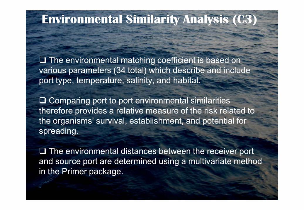
Environmental Similarity Analysis (C3)
The environmental matching coefficient is based on various parameters (34 total) which describe and include port type, temperature, salinity, and habitat.
Comparing port to port environmental similarities gtherefore provides a relative measure of the risk related to the organisms’ survival, establishment, and potential for spreading.
The environmental distances between the receiver port and source port are determined using a multivariate method in the Primer package.

Originally the IMO-Globallast software included a total of357 ports world wide.
Th i t l t d t ft d d t
Port Environmental Data
The environmental port data software was expanded to599 ports world wide by the Canadian Transportdatabase for 2006.

In the content of this project;
There are 55 ballast water source ports for the CMT.
Environmental data of 34 ports were taken from theoriginal IMO-Globallast software directly.
Environmental data of 11 ports (Augusta/Priolo, Cadiz,
Port Environmental Data
p ( g , ,Cartagena, Huelva, Kwinana, Mohammedia, PointTupper, San Nicolas, Savona, Tarragona, Tartous) weretaken from the expanded Canadian software.
For the remaining 10 (Agioi Theodoroi, Corpus Christi,Haifa, Leixoes, Falconara Marittima, Milazzo, SantaPanagia, Salalah, Ashkelon, Ceyhan) ports not presentin either of these software, databases from differentsources were used.

Risk species and NIS Data for C4 Calculation
One of the BWRA objectives was to identify ‘high-risk’ species that may be transferred to receiver port.
In the globallast database for each species;• taxonomic details• bioregion distribution
ti / i t d d t t• native / introduced status• level of threat assigned to a species
Database can be displayed for reviewing, editing and updating purposes.
The GloBallast database was revised with recently added species from the Turkish bioregions
Bioregions represent environmentally similar geographic areas. If a species is found established in one part of a
bioregion, there is a good chance it can spread via
CEYHAN MARINE TERMINAL BALLAST WATER RISK ASSESSMENT
natural or human – mediated processes to other sites in the same bioregion.

IMO-GloBallast divides the world into 204 bioregions

Turkish seas are divided up into 4 bio-regions;1. Mediterranean Sea (MED-V)2. Aegean Sea (MED VI)3. Marmara Sea (MED-VIII)4. Black Sea Coast (MED-IX-A)
CMT is located on the MED-V Bio-Region

Proportion of the BW volume discharges in the IskenderunGulf according to the seas (June 2006 – May 2007).
Northwest Atlantic12%
BlackSea/Marm. Sea1%
Med. Sea63%
Red Sea3%
Northeast Atlantic11%
Indian Pasific9%
12%
Northwest Pasific1%
According to the 154 visit records between June 2006 and May 2007, the total volume of ballast water discharged to the CMT was 7.532.118tonnes.

Ballast Water Source Ports for the CMT

Highest frequency of BW discharges at the CMT;
• North-West Mediterranean port of Fos sur Mer (France; 9.89%) • Italian Adriatic port of Trieste (Italia; 8.79 %),• The port of Singapore (Singapore; % 3.85),• The South–East of Mediterranean ports of Ashkelon (Israel 3.85%)• Sidi Kerir (Egypt; % 3.30), and • East Mediterranean port of Piraeus (Greece; 3.30%).
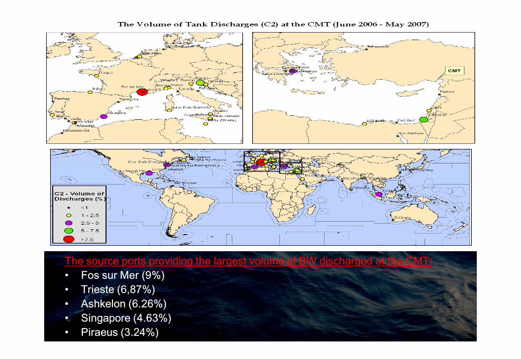
The source ports providing the largest volume of BW discharged at the CMT:• Fos sur Mer (9%)• Trieste (6,87%)• Ashkelon (6.26%)• Singapore (4.63%)• Piraeus (3.24%)

Partial list of identified source ports in the Ceyhan MarineTerminal database, showing proportions of recorded ballast tankdischarges (C1*) and volumes (C2*)
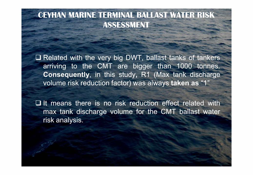
Related with the very big DWT, ballast tanks of tankersarriving to the CMT are bigger than 1000 tonnes.Consequently, in this study, R1 (Max tank dischargevolume risk reduction factor) was always taken as “1”
CEYHAN MARINE TERMINAL BALLAST WATER RISK ASSESSMENT
It means there is no risk reduction effect related withmax tank discharge volume for the CMT ballast waterrisk analysis.

• The most similar port to the CMT is Santa Panagia (Italy) port in the West Mediterranean (C3= 0.59)• The most environmentally similar source ports beyond the Mediterranean region is Mohammedia in the North East Atlantic (C3=0.52).

The most environmentally dissimilar ports trading withthe CMT are (i.e. C3’s below 0.1):
Come By Chance (Canada, North West Atlantic)
Kwinana (Australia, Indian Pacific)
CEYHAN MARINE TERMINAL BALLAST WATER RISK ASSESSMENT
Kwinana (Australia, Indian Pacific)
Fort Mifflin (USA, North West Atlantic)
Port Richmond (USA, North West Atlantic)
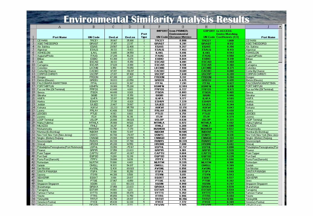
Environmental Similarity Analysis Results

The highest value;The port of Ningbo (Beilun) Zhejiang (China) from NWP-3A Bioregion with C4 = 0.577

Ranking of BW source ports identified for the CMT, according to the size oftheir risk species threat (C4)
Risk Assessment Results:
The database calculates the relative overall risk (ROR) of a potentially harmful introduction for all source ports that have C1-C4 coefficients and R1-R2 factors.
The ROR value for each source port represents a proportion of the threat posed against the CMT as a resultproportion of the threat posed against the CMT as a result of its contemporary trading pattern (June-2006 / May-2007).
After calculating the ROR’s, the database generates a large output table listing the source ports and their coefficients, risk-reduction factors, and the ROR value, plus the five ROR categories used for GIS plotting and the standardised ROR (S-ROR) values.

GIS world map outputs showing the location and categories of relative overall risk (ROR) of the BW source ports identified for
the CMT

BWRA and Relative Overall Risk and for CMT

BWRA and Relative Overall Risk and for CMT

From the164 visit records in the database, the project standard identified 6 ofthe 54 source ports as representing the “highest” risk group.
These ports with highest risk factor were all Mediterranean
The highest risk ports were led by Ashkelon (ROR = 0.28; S-ROR = 1.0) andHaifa (ROR = 0.28; S-ROR = 0.98), followed by Sidi Kerir and Tartous withthe same risk values (ROR = 0.27; S-ROR= 0,95), Fos Sur Mer (ROR=0.25;S-ROR= 0,89) and Augusta/Priola (ROR = 0.24; S-ROR= 0.84).
Risk Assessment Results (contd.):
The source port with the lowest ROR (0.02; S-ROR = 0) was Kwinana in theSouth Westhern Australia (Table 8). Kwinana is located near a river, and itssalinity is between % 0.4 and % 0.18 depending on the seasons.
The project-standard method classified 6 ports in the highest risk category,and these were all Mediterranean .
This outcome was to a large part determined by the size of theirenvironmental matching coefficients (C3), together with relatively shortvoyage durations (R2).

Ceyhan Marine Terminal Crew
Undersecretariat of Maritime Affairs
ACKNOWLEDGEMENTS
Mr. Jose Matheickal
THANK [email protected]