Embed Size (px)
Citation preview

Central IllinoisLincoln Logs
Volume 5 Issue 3 Fall 2002
WCM Rod Palmer to Retire November 2ndLeisurely DaysAhead for Rod
Palmer
by Melissa Byrd,Meteorologist
After 44 years and 4 months, Rod Palmeris calling it a day when he retires onNovember 2nd, 2002.
Rod started his career in June of 1958 with theWeather Bureau at Stampede Pass in WashingtonState at 4,000 feet elevation where the station was
snowbound 7 months of the year making itnecessary to snowshoe or ski in and out every twoand a half weeks. As soon as he left in 1960, thestation received a snowmobile for going up anddown the mountain! His next stop was TatooshIsland, Washington, off the northwest tip of thestate. Duty here was for five weeks on and thentwo off with transportation back and forth from themainland provided by the Coast Guard, mostly invery small, slow boats. Many exciting adventureswere experienced both in travel to and from theisland and life on the island, itself. In the summer of1963, Rod wasselected for a forecaster/briefer position inFairbanks, Alaska where he ended up spendingseven years as a “sourdough!” Unique experiencesup north were involvement in a year of ozoneresearch, making flight packages for Europe to Asiaflights, filling in as Fire Weather Forecaster,temporary duty at Barter Island on the northeastArctic coast in January in the dead and dark ofwinter, experiencing a 5.5 magnitude earthquake,watching the building of the Prudhoe Bay oil fieldcomplex with a continuous flight line of airplanes dayand night for over a year, studying math and physicsat the University of Alaska, releasing a weatherballoon at 50 below zero, making a morningtemperature reading of 62 below, watching thespectacular aurora borealis near its origin, andexperiencing Fairbank’s 100-year flooding of theChena River.
In this issue...
Leisurely Days Ahead for Rod Palmer . . . 1From the Desk of the State Climatologist
. . . . . . . . . . . . . . . . . . . . . . . . . . . . . 3New Voices Debut on NOAA Weather
Radio . . . . . . . . . . . . . . . . . . . . . . . . 4Open Radar Product Generator Improves
Radar Operations . . . . . . . . . . . . . . 4A Hot Summer for Central Illinois . . . . . . . 5Winter Weather Preparedness Week . . . . 5Climatology Outlooks for the Next 30 to 90
Days . . . . . . . . . . . . . . . . . . . . . . . . . 6A Wet Severe Weather Season! . . . . . . . . 8
2 Volume 5 Issue 3 Fall 2002
He left Alaska in the fall of 1970, headed forWSFO St Louis via an Alaska State Ferry throughthe inland waterway from Haines to Prince Rupert,then by road for the rest of the route. He bought anew car in Fairbanks that spring and was asked ifhe’d like air conditioning added. After asking thesalesman, “are you crazy?”, he found himselfspending big dollars to have air conditioning installedthe following summer in St. Louis! He spent onlyfive months at St. Louis.
Rod was promoted to Principal Assistant at WSOPeoria, IL in the spring of 1971. Here he served for18 years doing much of the spotter training andmedia relations for the office. He was involved withdeveloping a radio system connecting the WSO withcounty EOCs for use in severe weather that stillfunctions 31 years later. He also provided technicalguidance to an ad hoc committee to procuredoppler radar for central Illinois which resulted inthe eventual establishment of the site at WFOLincoln.
He transferred to WSO Springfield, IL in 1988 andafter completing the cross-over program at San JoseState, he converted from Official in Charge in 1992to Meteorologist in Charge (MIC) in 1993.
In 1995, both the SPI and PIA offices were closedand a new WFO opened at Lincoln where hebecame the first Warning CoordinationMeteorologist (WCM.). His first duty was to go toKansas City for a week and select the first panel offive forecasters for Lincoln and two for Paducah. From that original five, the office complement hasgrown to 23.
Rod’s most satisfying accomplishments in his sevenyears at the new Lincoln office has beenestablishing a HAM radio base station including therecruitment of a dedicated group of volunteerHAMS to receive and disseminate severe weatherreports. Promoting the expansion of the coverage
of NOAA Weather Radio (NWR) in the state ofIllinois from its original seven to the current 28transmitter sites. Being one of the originalcommittee members who started the annual SevereWeather Seminar for weather spotters held eachyear in Bloomington. He was able to work withcounty and city ESDA coordinators to certify sevencommunities as StormReady. He joined with asmall group ofpeople from the Illinois Water Survey and our NWSoffice to see the rebirth of a local chapter of theAmerican Meteorological Society of which he waselected the first President. The Central IllinoisChapter now has about 45 active members.
His last project (if and when completed), heconsiders the most important. This is thedevelopment and deployment of a Severe WeatherPreparedness and Safety course to be taught in allof Illinois’ schools. This will give each student andfuture adult, life-long learning skills to cope with alltypes of severe weather through the rest of theirlives. He is working with Ed Holicky, one of ourforecasters, the Illinois Education Association (IEA)and IEMA to develop the curriculum in the form ofan educational CD to be used at the elementary,middle, and high school levels.
Rod says he will miss all his co-workers in theNWS, emergency managers, law enforcement folks,HAMS, fire fighters and EMTs, governmentofficials at the local, county, and state levels, folks atthe Illinois Water Survey and the Midwest ClimateCenter, all of the people in academia, especially atthe university and college level, members of theCentral Illinois Chapter of the AMS, and all theindividuals with whom he has come in contact withover the years, especially the ones that stated, “Iknow you.....you’re the voice on the weatherradio!” He’ll really miss being able to bring a smileand a laugh to all of the people mentioned, above, with a daily joke or two!
3 Volume 5 Issue 3 Fall 2002
After retirement, Rod intends, to take however long,to find that section of the country that is “paradise”! He’s trying to escape summer heat and humidity andwinter wind and snow. When he first came to theMidwest from Alaska, someone warned him,“Never live in an area where they grow corn andsoy beans. It’s unfit for human habitation”! Afternearly 32 years, Rod has managed to adjust to hissurroundings!
After playing tennis since high school, he’s recentlytaken up golf. Gardening and stream fishing areother interests. Some volunteer work such astutoring adult reading and, possibly, working in some area of disaster recovery work with the RedCross will occupy his time. He also has to cheer onhis beloved Cubs, even though they are in their 42nd
year of rebuilding the team!
From the Desk ofthe State
Climatologist
by Jim Angel, StateClimatologist
I recently attended a NOAA-sponsoredforum on modernizing the NWS cooperativenetwork in Washington, D.C. on September
18. While details on the instrumentation andmethods are still incomplete, the modernization hasgained support from senior NOAA officials. Thisputs it one step closer to becoming a reality. Thegeneral plan is to provide coop observers with newinstrumentation that will record hourly temperatureand precipitation data that will be relayedautomatically to the NWS in real time. Observerswill still be collecting daily observations of snow falland snow depth and making additional comments.In addition, many sites will be equipped with soilmoisture sensors. This is a critical measurement thatis lacking in most parts of the country.
So far, 2002 has been an interesting year with oneextreme followed by another. We started out withthe 2nd warmest winter (December-February) onrecord since 1895 at 6.1F above normal. Thewarmest winter on record was 1931-1932 at 8.2F.Snowfall was down, only 50-75% of normal. Infact, most of our significant snow fell in lateFebruary and early March when 5-10 inches fellover in the northern half of the ILX region.
Following the very mild winter was a period ofheavy and widespread rain. For the entire state, thiswas the 6th wettest spring (March - May) since1895 with 15.65 inches, some 4.5 inches aboveaverage. The central third of the state received someof the largest amounts. Several individual coopstations reported more than 20 inches of rain incentral Illinois this spring.
The rainfall stopped suddenly in mid-June and reallydid not return until mid-August for most of the state.For that time period, this was the 8th driest since1900 (4.23 inches or 56% of average). It was closeto being as dry as 1988. The only difference is thatin 1988 the extremely dry spring had alreadydepleted soil moisture by mid-June. While soilmoisture was in great shape going into the dry spellthis summer, the demand on soil moisture was suchthat the upper layers dried out in a matter of weeks.The above-average temperatures this summeradded to the stress on crops. This was the 14th
warmest summer since 1895 (2F above average).Fortunately, rains returned to the northern two-thirds of the state after mid-August. Despite the drysummer, the first 8 months of this year are the 15th
warmest and 16th wettest since 1895.
The outlook for fall and winter will be determined inpart by the strength and timing of the current El Niñoevent in the Pacific Ocean. El Niño occurs when seasurface temperatures along the equator in the Pacificare much above average. The impacts on weather inthe fall are not great but we typically have milder
4 Volume 5 Issue 3 Fall 2002
winters. This is reflected in the NWS ClimatePrediction Center outlook, which is calling for anincreased chance of warmer temperatures duringwinter. In addition, an increased chance of below-average precipitation is possible in the eastern half ofthe corn-belt with Illinois on the western edge. Theincreased chance for dryness persists in Illinois andthe eastern corn-belt through next spring. All thestatistics discussed in this article and therelationships between El Niño and Illinois weatherwere developed from coop data over the lastcentury. Keep up the good work.
New Voices Debuton NOAA
Weather Radio
by Chris Geelhart, NOAAWeather Radio Focal Point
Anew voicing system was implementedon our NOAA Weather Radio stationsthis spring. Debut of the new voices,
one male and one female, began at the end of May. Most messages are now using the new voices. However, the old system will be retained for backuppurposes.
The voicing system was selected last summer, withcomments from 19,000 visitors to NWSHeadquarters’ NWR homepage a significant part ofthe process. Several NWS offices nationwidebegan testing the new system in January. Afterevaluations from the test sites, it was decided todeploy the system nationally. The original rolloutperiod of late March was pushed back, to allowupgraded software to be part of the deployment.
As we implement the voices, you may hearoccasional mispronunciations. Updates to thesoftware’s pronunciation dictionary will be ongoing,as we evaluate how words are pronounced indifferent contexts. However, if you hear something
consistently being mispronounced, let us know. You may have heard a message that we missed, orwe may have incorrectly entered the pronunciationof a town.
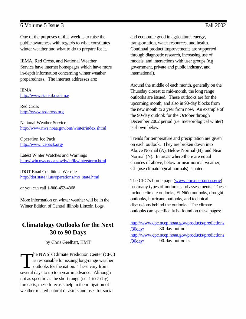
Open Radar Product GeneratorImproves Radar Operations
by Ed Martin, Electronic Systems Analyst
In September of 2001 the Radar ProductGenerator (RPG) at Lincoln was upgradedto a SUN based Open Radar Product
Generator (ORPG). The main processor is anUltraSPARC 440 MHZ Processor with a minimumof 256MB or RAM. It replaced a ConcurrentMicroFive and Versalia Motorola Eurobuscommunications equipment. The Fortranapplications software was replaced with softwarewritten in C/C ++.
One of the biggestimprovements was theability to utilize the TCP/IPcommunications package.This enabled a direct LANconnection to the AWIPS(Advanced WeatherInteractive Processing System). This connection wasmade very recently. The increase in the speed ofthis connection will enable forecasters to receivealmost twice as many radar products than they wereable to receive under the old architecture.
Another improvement was the addition of a BaseData Distribution Server. This server utilizes VirtualLANS to send data to officially approved users.Currently ILX sends data to MIT, Lincoln Labs forthe FAA. This connection also enabled us to beginsending near real time archive data to NCDC andstop recording to 8MM tapes.

5 Volume 5 Issue 3 Fall 2002
The ORPG is the first step in upgrading the entireradar system to take advantage of commercialadvancements in hardware and software.
A Hot Summerfor Central Illinois
by Kirk Huettl,Meteorologist
The summer of 2002 was fairly hot acrossCentral Illinois. June, July and Augustare considered the three meteorological
summer months. Looking at Peoria, Springfield,Champaign and Lincoln, the average high was 86degrees, or between 1 and 3 degrees above normal. There were between 30 and 36 days with highs inthe 90s, with Champaign having the most of these 4locations. Typically Springfield has 26 days andPeoria has 18 days with high temperatures in the90s. The hottest day was on Sunday July 21st when afternoon temperatures sizzled between 95and 100 degrees. Peoria and Champaign reached98 degrees, Lincoln was 97, and Springfield was95. Peoria had it’s 10th hottest July on record witha monthly mean temperature of 79.1 degrees. Itwas even hotter across Southeast Illinois whereLawrenceville near the Wabash River had 60 daysin the 90s this season. Lawrenceville came close tothe century mark on 3 days, reaching 98 degrees onJuly 5th , July 9th and September 9th.
Rainfall was unevenly distributed during thesesummer months. Dry and hot conditions occurredfor 5 weeks from Flag Day in mid June until the last10 days of July. It dry and hot again during the lastweek of August which lasted through the first twoweeks of September. Areas along and southeast ofI-70 experienced drier drought like conditions. Lincoln had the most rainfall with 18.76 inches or6.44 inches above normal. The 4.22 inches of rainthe fell in Lincoln on August 16 set a 24 hour recordfor August, and was the 6th highest single day total.
The highest was an inch more with 5.22 inches onMay 12, 1914. August ended up with 8.58 inchesmaking it the wettest August on record in Lincoln. In fact, 16.37 inches of rain fell in Lincoln duringJuly and August, most of that accumulated betweenJuly 22 and August 23. Springfield received 13.32inches of rain which was 2.61 inches above normal. Peoria and Champaign had close to normal rainfall. Peoria received 11 inches which was 0.02 inchesbelow normal, and Champaign has 12.78 incheswhich was 0.47 inches below normal. With an El Niño in place, the outlook for this fallfrom the Climate Prediction Center is calling forclose to normal rainfall and temperatures acrossCentral Illinois. The outlook for this winter calls forabove normal temperatures. Below normalprecipitation is expected across Southeast Illinoiswith the rest of the state near normal.
Winter Weather PreparednessWeek
November 17th through 23rd, 2002
It may be fall...but winter will be around thecorner before you know it...so be preparedfor all that can happen. The state of Illinois
will hold it’s annual Winter Weather PreparednessWeek November 17th through the 23rd.
There was a change made dealing with the criteriathe Weather Service uses for a Snow Advisory. If4 to 6 inches of snow is forecast to fall...it will nowbe an advisory...rather than a Heavy SnowWarning. When snowfall is forecast to exceed 6inches...a Heavy Snow Warning will be issued.
Another change made was the addition of aFreezing Fog Advisory. A freezing fog advisory isdefined as a “very light ice accumulation frompredominately freezing fog”.
6 Volume 5 Issue 3 Fall 2002
One of the purposes of this week is to raise thepublic awareness with regards to what constitutes winter weather and what to do to prepare for it.
IEMA, Red Cross, and National WeatherService have internet homepages which have morein-depth information concerning winter weatherpreparedness. The internet addresses are:
IEMAhttp://www.state.il.us/iema/
Red Cross http://www.redcross.org
National Weather Servicehttp://www.nws.noaa.gov/om/winter/index.shtml
Operation Ice Packhttp://www.icepack.org/
Latest Winter Watches and Warningshttp://iwin.nws.noaa.gov/iwin/il/winterstorm.html
IDOT Road Conditions Websitehttp://dot.state.il.us/operations/mo_state.html
or you can call 1-800-452-4368
More information on winter weather will be in theWinter Edition of Central Illinois Lincoln Logs.
Climatology Outlooks for the Next30 to 90 Days
by Chris Geelhart, HMT
The NWS’s Climate Prediction Center (CPC)is responsible for issuing long-range weatheroutlooks for the nation. These vary from
several days to up to a year in advance. Althoughnot as specific as the short range (i.e. 1 to 7 day)forecasts, these forecasts help in the mitigation ofweather related natural disasters and uses for social
and economic good in agriculture, energy,transportation, water resources, and health. Continual product improvements are supportedthrough diagnostic research, increasing use ofmodels, and interactions with user groups (e.g.government, private and public industry, andinternational).
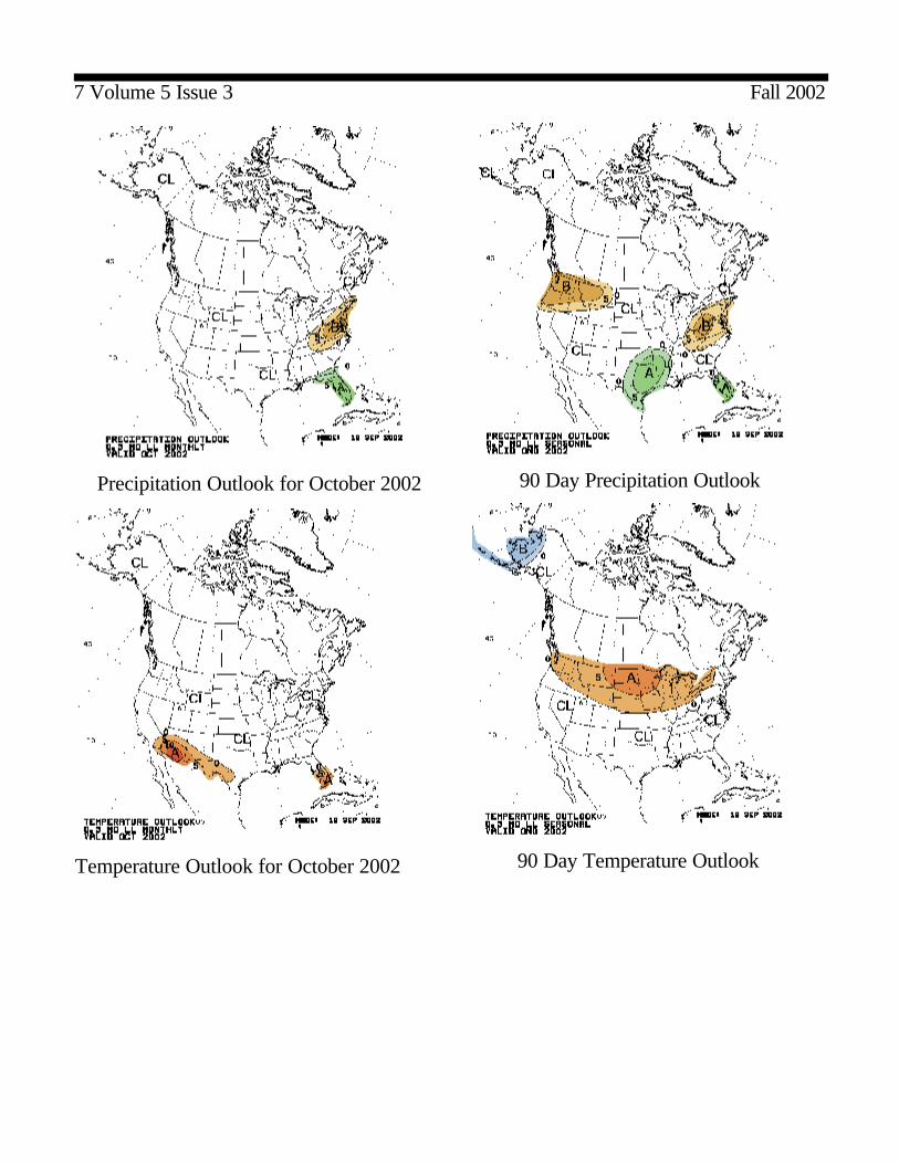
Around the middle of each month, generally on theThursday closest to mid-month, the long rangeoutlooks are issued. These outlooks are for theupcoming month, and also in 90-day blocks fromthe new month to a year from now. An example ofthe 90-day outlook for the October throughDecember 2002 period (i.e. meteorological winter)is shown below.
Trends for temperature and precipitation are givenon each outlook. They are broken down intoAbove Normal (A), Below Normal (B), and NearNormal (N). In areas where there are equalchances of above, below or near normal weather,CL (use climatological normals) is noted.
The CPC’s home page (www.cpc.ncep.noaa.gov)has many types of outlooks and assessments. Theseinclude climate outlooks, El Niño outlooks, droughtoutlooks, hurricane outlooks, and technicaldiscussions behind the outlooks. The climateoutlooks can specifically be found on these pages:
http://www.cpc.ncep.noaa.gov/products/predictions/30day/ 30-day outlookhttp://www.cpc.ncep.noaa.gov/products/predictions/90day/ 90-day outlooks
7 Volume 5 Issue 3 Fall 2002
Temperature Outlook for October 2002
90 Day Precipitation Outlook
90 Day Temperature Outlook
Precipitation Outlook for October 2002
8 Volume 5 Issue 3 Fall 2002
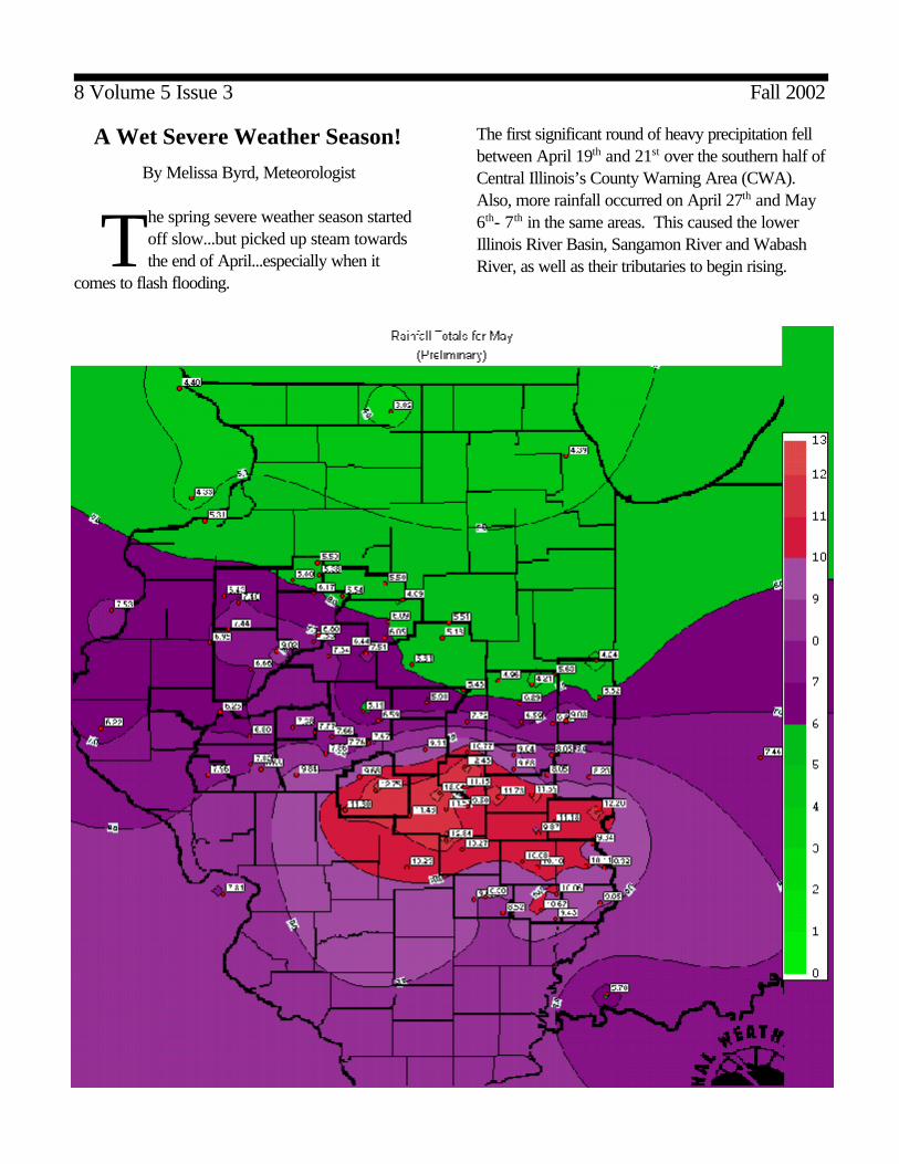
A Wet Severe Weather Season!
By Melissa Byrd, Meteorologist
The spring severe weather season startedoff slow...but picked up steam towardsthe end of April...especially when it
comes to flash flooding.
The first significant round of heavy precipitation fellbetween April 19th and 21st over the southern half ofCentral Illinois’s County Warning Area (CWA). Also, more rainfall occurred on April 27th and May6th- 7th in the same areas. This caused the lowerIllinois River Basin, Sangamon River and WabashRiver, as well as their tributaries to begin rising.
9 Volume 5 Issue 3 Fall 2002
So by the time Mother’s Day weekend rolledaround, a large section of Central Illinois wassaturated from the previous rains when the nextsignificant round of heavy precipitation approachedthe area.
This time the first round of heavy rain fell on theupper sections of the Illinois River Basin on May11th ...generally affecting areas north of a Rushvilleto Bloomington line. With just a few hours of littleor no precipitation, another round of heavy rainsmoved into the CWA, affecting areas south of aRushville to Bloomington line, an area that did notneed anymore rain!
The rain persisted for over 12 hours with rainfallamounts over 4 inches in some locations. Numerous flash flood warnings (44) were issued forCentral Illinois over the 2 day period. The flashflooding eventually turned to significant river floodingwith a couple of locations reaching record or nearrecord river flood levels. The Embarras River atLawrenceville reached a record stage of 24.27 feeton May 16th, over 14 feet above flood stage!
River flooding finally subsided by the end of May,when the weather conditions for Central Illinois wentthe opposite direction...hot and dry!
For more information on the flooding that CentralIllinois experienced go to the following section onour website... www.crh.noaa.gov/ilx/stormd.htm . Here you can click on each monthly storm report forthe area for the past two years.
As for tornado activity, Central Illinois has only seen9 tornadoes...3 F1s and 6 F0s. Additional tornadoinformation can be found atwww.crh.noaa.gov/ilx/2002tornadoes.htm .
The Central Illinois Lincoln Logs is a quarterlyreview of NWS activities in Central Illinois and isavailable on our internet page athttp://www.crh.noaa.gov/ilx
Your comments are welcomed and can beaddressed to either editor at our office. WinterCentral Illinois Lincoln Logs Issue to be issued bythe middle of November 2002.
Co-editors.......
Rod Palmer, Warning Coordination Meteorologist [email protected]
Billy Ousley, Data Acquisition Program [email protected]
Newsletter designer/editor....
Melissa Byrd, [email protected]
Meteorologist-In-Charge........
Ernie Goetsch


![From Your President Contents S]mmer Is ]pon Us! · practical sessions on these topics, he’ll lead a conducting masterclass, and he’ll share thoughts about the importance of our](https://img.dokumen.tips/doc/110x75/5f5433b36b4aa606750915ca/from-your-president-contents-smmer-is-pon-us-practical-sessions-on-these-topics.jpg)