Embed Size (px)
Citation preview
7/26/2011
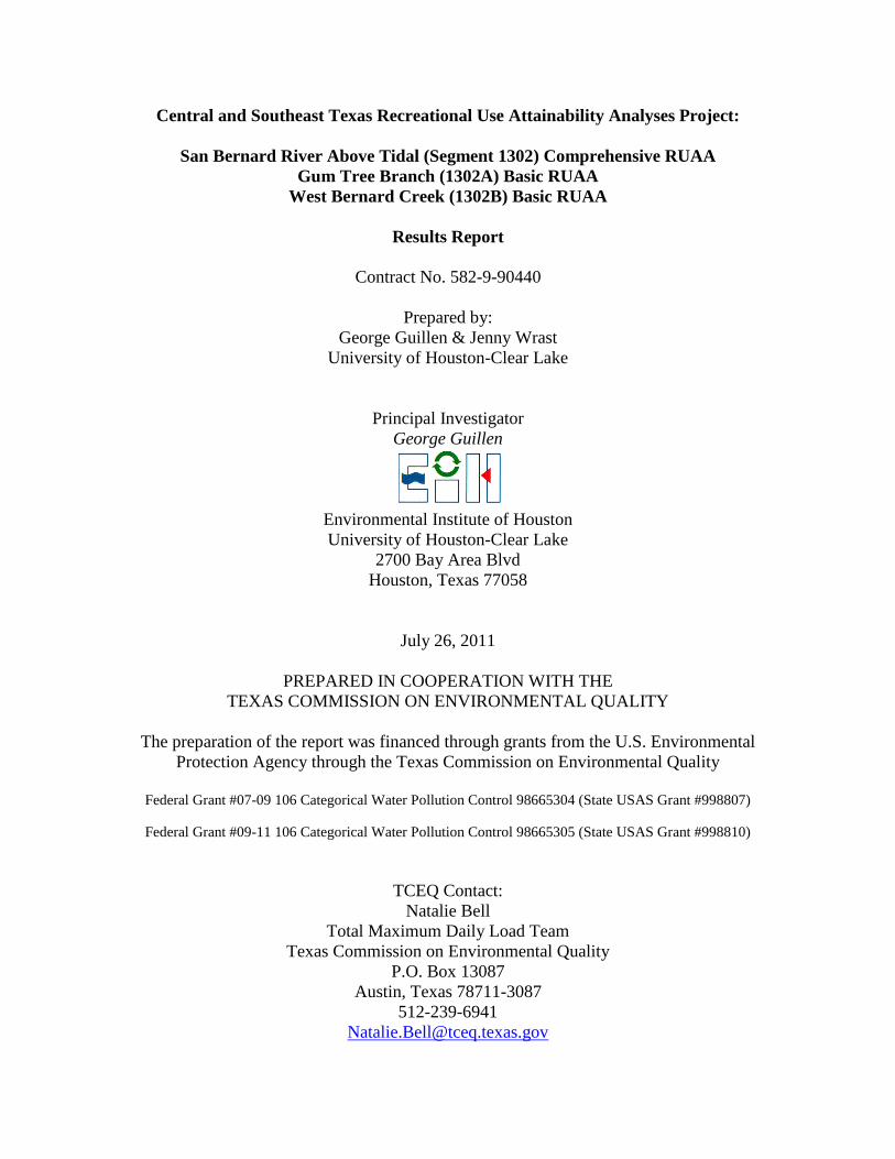
Central and Southeast Texas Recreational Use Attainability Analyses Project:
San Bernard River Above Tidal (Segment 1302) Comprehensive RUAA
Gum Tree Branch (1302A) Basic RUAA
West Bernard Creek (1302B) Basic RUAA
Results Report
Contract No. 582-9-90440
Prepared by:
George Guillen & Jenny Wrast
University of Houston-Clear Lake
Principal Investigator
George Guillen
Environmental Institute of Houston
University of Houston-Clear Lake
2700 Bay Area Blvd
Houston, Texas 77058
July 26, 2011
PREPARED IN COOPERATION WITH THE
TEXAS COMMISSION ON ENVIRONMENTAL QUALITY
The preparation of the report was financed through grants from the U.S. Environmental
Protection Agency through the Texas Commission on Environmental Quality
Federal Grant #07-09 106 Categorical Water Pollution Control 98665304 (State USAS Grant #998807)
Federal Grant #09-11 106 Categorical Water Pollution Control 98665305 (State USAS Grant #998810)
TCEQ Contact:
Natalie Bell
Total Maximum Daily Load Team
Texas Commission on Environmental Quality
P.O. Box 13087
Austin, Texas 78711-3087
512-239-6941

San Bernard Watershed RUAA Final Report 7/26/2011 7/ 7/26/2011
1
Table of Contents Introduction ..................................................................................................................................... 6
Problem Statement ...................................................................................................................... 6
Objectives ................................................................................................................................... 6
Description of Waterbody ........................................................................................................... 8
San Bernard River Above Tidal ............................................................................................. 8
Gum Tree Branch .................................................................................................................... 8
West Bernard Creek ................................................................................................................ 9
Watershed Environmental Features and Population Characteristics .......................................... 9
Watershed Characterization ...................................................................................................... 11
Permitted Discharges (Municipal, Industrial, Storm water) ..................................................... 11
Potential Nonpoint Sources....................................................................................................... 11
History of Recreational Use in the San Bernard River Above Tidal Watershed .......................... 14
Historical Summary .................................................................................................................. 14
Boating ...................................................................................................................................... 14
Fishing....................................................................................................................................... 16
Swimming ................................................................................................................................. 17
Parks .......................................................................................................................................... 18
Site Reconnaissance Summary ..................................................................................................... 20
Methodologies............................................................................................................................... 20
RUAA Survey Site Selection and Descriptions ........................................................................ 20
San Bernard River Above Tidal Field Survey Sites ................................................................. 21
Gum Tree Branch Field Survey Sites ....................................................................................... 25
West Bernard Creek Field Survey Sites.................................................................................... 28
Sampling Methods .................................................................................................................... 31
Field Survey Descriptions ......................................................................................................... 32
Interviews .................................................................................................................................. 33
Results ........................................................................................................................................... 33
San Bernard River Above Tidal RUAA Results....................................................................... 33
Physical Evaluation and Flow .............................................................................................. 33
Surrounding Conditions that Impede Recreation and Channel Obstructions ...................... 34
Recreational Uses ................................................................................................................. 34
Interviews .............................................................................................................................. 35
Summary ............................................................................................................................... 41
San Bernard Watershed RUAA Final Report 7/26/2011 7/ 7/26/2011
2
Gum Tree Branch RUAA Results............................................................................................. 43
Physical Evaluation and Flow .............................................................................................. 43
Surrounding Conditions that Impede Recreation and Channel Obstructions ...................... 43
Recreational Uses ................................................................................................................. 44
Interviews .............................................................................................................................. 44
Summary ............................................................................................................................... 46
West Bernard Creek RUAA Results ......................................................................................... 47
Physical Evaluation and Flow .............................................................................................. 47
Surrounding Conditions that Impede Recreation and Channel Obstructions ...................... 47
Recreational Uses ................................................................................................................. 48
Interviews .............................................................................................................................. 48
Summary ............................................................................................................................... 53
Literature Cited ............................................................................................................................. 54
RUAA Summary Form ................................................................................................................. 55

San Bernard Watershed RUAA Final Report 7/26/2011 7/ 7/26/2011
3
List of Figures
Figure 1. Land use and land cover in the San Bernard River Watershed from the Watershed
Protection Plan by the Houston-Galveston Area Council............................................................. 10
Figure 2. Permitted outfalls in the San Bernard River Above Tidal Watershed for Recreational
Use Attainability Analysis Survey. ............................................................................................... 13
Figure 3. One of the photographs submitted by David Heinicke (TPWD) paddling trip organizer
of a group paddle on the San Bernard River at Bates Allen Park on April 12, 2010. .................. 15
Figure 4. A screen shot of the TexasKayakFisherman.com forum where the San Bernard River
as a popular paddling destination is a common topic of discussion. ............................................ 15
Figure 5. Smug-Mug user: TaffyWaffy posted this photo along with many others in a public
album named: San Bernard River at Kendelton. .......................................................................... 16
Figure 6. Photo from the Friends of the River, San Bernard website (photo album 2009) of a
large gar that was caught in San Bernard River Above Tidal at Mound Creek (bottom part of
segment). ....................................................................................................................................... 17
Figure 7. Map of the parks that are directly adjacent to the San Bernard River Above Tidal. Park
Number corresponds to Table 2. ................................................................................................... 19
Figure 8. Picture of field survey site 10, showing the general representation of the physical
conditions seen on the San Bernard River Above Tidal (Segment 1302) .................................... 22
Figure 9. Comprehensive RUAA survey sites on the San Bernard River Above Tidal (Segment
1302) selections based on river mile/assessment units, accessibility, and recreational features .. 24
Figure 10. Picture of field survey site 2, showing the general representation of the physical
conditions seen on Gum Tree Branch (1302A) ............................................................................ 26
Figure 11. Basic RUAA survey sites on Gum Tree Branch (1302A) selections based on river
mile/assessment units, accessibility, and recreational features ..................................................... 27
Figure 12. Picture of field survey site 8, showing the general representation of the physical
conditions seen on West Bernard Creek (1302B) ......................................................................... 29
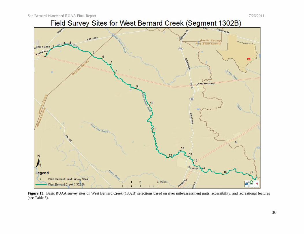
Figure 13. Basic RUAA survey sites on West Bernard Creek (1302B) selections based on river
mile/assessment units, accessibility, and recreational features ..................................................... 30
Figure 14.Comprehensive RUAA survey sites on the San Bernard River Above Tidal (Segment
1302) selections based on river mile/assessment units, accessibility, and recreational features.
Constructed from field observations.. ........................................................................................... 39

San Bernard Watershed RUAA Final Report 7/26/2011 7/ 7/26/2011
4
List of Tables
Table 1. Permitted outfalls in the San Bernard River Above Tidal Watershed. ................................. 12
Table 2. Parks located directly adjacent to the San Bernard River Above Tidal. ............................... 18
Table 3. Field survey sites for the Comprehensive RUAA Survey on the San Bernard River Above
Tidal (Segment 1302) .......................................................................................................................... 23
Table 4. Field survey sites for the Basic RUAA Survey on Gum Tree Branch (1302A) ................... 26
Table 5. Field survey sites for the Basic RUAA Survey on West Bernard Creek (1302B) ................ 29
Table 6. Average physical parameters from the Comprehensive RUAA two field surveys conducted
on the San Bernard River Above Tidal (Segment 1302) ..................................................................... 36
Table 7. Physical Characteristics of Riparian Zone and Dominant substrate of the field survey sites
sampled during the Comprehensive RUAA on the San Bernard River Above Tidal (Segment 1302) 37
Table 8. Recreational uses observed and interviewed documented by number of observed
occurrences for the San Bernard River Above Tidal (Segment 1302) collected during the
Comprehensive RUAA. ....................................................................................................................... 38
Table 9. Impediments, evidence of recreational uses, observed recreational uses, and interviewed
documented uses by site on the San Bernard River Above Tidal (Segment 1302) for the
Comprehensive RUAAs by location. .......................................................................................... 40 & 41
Table 10. Average physical parameters from the basic RUAA field surveys conducted on Gum Tree
Branch (1302A) ................................................................................................................................... 45
Table 11. Physical Characteristics of Riparian Zone and Dominant substrate of the field survey sites
sampled during the basic RUAA on Gum Tree Branch (1302A) ........................................................ 45
Table 12. Impediments and evidence of recreational uses by site on Gum Tree Branch (1302A) for
the basic RUAA by location. ............................................................................................................... 46
Table 13. Average physical parameters from the basic RUAA field surveys conducted on West
Bernard Creek (1302B). ....................................................................................................................... 49
Table 14. Physical Characteristics of Riparian Zone and Dominant substrate of the field survey sites
sampled during the basic RUAA on West Bernard Creek (1302B) ................................................... 50
Table 15. Recreational uses observed and interviewed documented by number of observed
occurrences for West Bernard Creek (1302B) collected during the basic RUAA. .............................. 51
Table 16. Impediments, evidence of recreational uses, observed recreational uses, and interviewed
documented uses by site on West Bernard Creek (1302B) for the basic RUAA by location. ............. 52

San Bernard Watershed RUAA Final Report 7/26/2011 7/ 7/26/2011
5
Appendices
Appendix 1 Contact Information Forms and Supporting Documents
Appendix 2 Field Data Sheets
Appendix 2-A San Bernard River Above Tidal Field Data Sheets and Database
Appendix 2-B Gum Tree Branch Field Data Sheets and Database
Appendix 2-C West Bernard Creek Field Data Sheets and Database
Appendix 3 Interview Sheets
Appendix 3-A San Bernard River Above Tidal Interview Sheets and Database
Appendix 3-B Gum Tree Branch Interview Sheets and Database
Appendix 3-C West Bernard Creek Interview Sheets and Database
Appendix 4 EIH Interview Protocol
Appendix 5 Photographic Record
Appendix 5-A San Bernard River Above Tidal Photographic Record
Appendix 5-B Gum Tree Branch Photographic Record
Appendix 5-C West Bernard Creek Photographic Record
Appendix 6 Weather Condition Summary
Appendix 6-A San Bernard River Above Tidal Weather Condition Summary
Appendix 6-B Gum Tree Branch Weather Condition Summary
Appendix 6-C West Bernard Creek Weather Condition Summary
Appendix 7 Public Meetings
Appendix 8 Interactive Google Earth Map
Appendix 8-A San Bernard River Above Tidal Interactive Google Earth Map
Appendix 8-B Gum Tree Branch Interactive Google Earth Map
Appendix 8-C West Bernard Creek Interactive Google Earth Map
Appendix 9 San Bernard Watershed QAP and Monitoring Plan

San Bernard Watershed RUAA Final Report 7/26/2011 7/ 7/26/2011
6
Introduction
Problem Statement
Recreational Use Attainability Analyses (RUAA) are scientific assessments that are used
to determine the existing and attainable recreational use for a waterbody, and assess if that use
might be different than the presumed recreational use as specified in the Clean Water Act. In
August 2010, one Comprehensive and two Basic RUAAs were initiated on three water bodies
within the San Bernard River Above Tidal watershed. A Comprehensive RUAA was performed
on the San Bernard River Above Tidal (Segment 1302), and a Basic RUAA was completed on
Gum Tree Branch (1302A) and West Bernard Creek (1302B). This RUAA Report will provide
the TCEQ Water Quality Standards Group with relevant information needed to determine the
appropriate attainable recreational use for the three water bodies in question. The completion of
these RUAAs consisted of several important interrelated components including 1)
reconnaissance and site selection, 2) conducting the basic or comprehensive RUAA, and 3)
public outreach. The objectives of each component are listed below.
Objectives
1. Reconnaissance and Site Selection
The primary objective of this phase was to select survey sites that would be accessible to
users and most likely characterize recreational uses in the watershed. This was accomplished
primarily with the input of local, state, and regional agency staff familiar with the watershed, as
well as aerial imagery. Reconnaissance surveys for the San Bernard River Above Tidal were
conducted on December 12, 2009 and January 6, 2010. An initial stakeholder meeting occurred
on February 2, 2010 at the Albert George Branch Public Library in Needville, Texas, at which

San Bernard Watershed RUAA Final Report 7/26/2011 7/ 7/26/2011
7
the site selections were discussed. Reconnaissance surveys for Gum Tree Branch were
conducted on June 22, 2010 and for West Bernard Creek on June 22-23, 2010.
2. Recreational Use Attainability Analysis
The primary objectives of the San Bernard River Above Tidal Watershed RUAAs was to
characterize the recreational use and potential impediments to recreational use for these streams.
The RUAA field surveys were conducted during the weekends in April and May of 2011, to
collect information on the waterbody and associated uses. Field surveys were conducted at
selected sites with the highest probability of detecting recreation use. The objectives for all three
water bodies were to document and characterize observed uses, site conditions (hydrology,
physical attributes), and weather during the RUAA field surveys. A historical information
review and interviews were also conducted for the San Bernard River Above Tidal
Comprehensive RUAA. The objective of the historical review and interviews was to supplement
the data obtained from the field surveys and increase the probability of detecting and
characterizing recreational uses in the segment.
3. Public Participation
The objective of the public participation phase was to solicit as much information on the
historical and current recreational uses in the San Bernard River Above Tidal, Gum Tree Branch,
and West Bernard Creek from various watershed stakeholders, including agency staff (such as
TCEQ, Texas Parks and Wildlife, Clean Rivers Partners, and State Soil and Water Conservation
Board), citizens, recreational user groups, and other interested parties. This included sending out
email and phone messages to key organizations and staff familiar with the watershed. The
stakeholder contact list is provided in Appendix 1. In addition, on February 2, 2009, an initial
stakeholder meeting was held to gather information on the watershed, including likely
San Bernard Watershed RUAA Final Report 7/26/2011 7/ 7/26/2011
8
recreational access points. Finally, a public meeting was advertised via public notice by TCEQ
and held at the Albert George Branch Public Library in Needville, TX on June 24, 2011 to
present the findings of this study and confirm with the attending public that findings were
concurrent with information on potential observed or known recreational uses (Appendix 7).
Study Area
Description of Waterbody
San Bernard River Above Tidal
The San Bernard River Above Tidal (Segment 1302) is located within the Brazos-
Colorado Coastal river basin. This classified segment is approximately 107 miles in length.
Segment 1302 begins at the saltwater barrier 3.2 km (2.0 miles) upstream of SH 35 in Brazoria
County to the headwaters above Bernard/Bostik Rd, southeast of New Ulm in Austin County.
This portion of the San Bernard River Above Tidal is predominately undeveloped, with the small
communities of East Bernard and Kendleton located in the middle of the watershed. Rice and
cotton farming dominate the landscape. The stream is gently sloped and bank access to the water
is easy in the upstream portions of the river. The banks become steeper and more difficult to
access the water downstream. The San Bernard River Above Tidal is on the Texas 303(d) list for
not meeting the state’s bacteria criteria associated with primary recreation uses in the lower 50
miles of the segment (TCEQ, 2008).
Gum Tree Branch
Gum Tree Branch is located within the Brazos-Colorado Coastal river basin.
Unclassified waterbody 1302A is approximately 15 miles in length. Waterbody 1302A begins at
the confluence with West Bernard Creek near Wharton CR 252 to the headwaters approximately

San Bernard Watershed RUAA Final Report 7/26/2011 7/ 7/26/2011
9
15 miles upstream near RR 102. Gum Tree Branch is intermittent in its upper reaches. Gum
Tree Branch is on the Texas 303(d) list for not meeting the state’s bacteria criteria associated
with primary recreation uses (TCEQ, 2008).
West Bernard Creek
West Bernard Creek is located within the Brazos-Colorado Coastal river basin.
Unclassified waterbody 1302B is approximately 40 miles in length. West Bernard Creek begins
at the confluence with the San Bernard River Above Tidal downstream of US Highway 59 to the
headwaters approximately 40 miles upstream near FM 1093. West Bernard Creek is intermittent
in its upper reaches. West Bernard Creek is on the Texas 303(d) list for not meeting the state’s
bacteria criteria associated with primary recreation uses (TCEQ, 2008).
Watershed Environmental Features and Population Characteristics
The main land use within the watershed is crop production and cattle grazing. Currently,
no major metropolitan areas are located in the watershed. Land uses within the watershed are
primarily rural and agricultural, with small scattered areas of urbanization (East & Hogan, 2003
& HGAC, 2011) (Figure 1).

San Bernard Watershed RUAA Final Report 7/26/2011
7/
7/26/2011
10
Figure 1. Land use and land cover in the San Bernard River Watershed from the Watershed Protection Plan by the Houston-Galveston Area Council found at:
http://www.h-gac.com/community/water/watershed_protection/sanbernard/default.aspx (accessed: 7/14/2011).
San Bernard Watershed RUAA Final Report 7/26/2011 7/ 7/26/2011
11
Watershed Characterization
The San Bernard River Above Tidal watershed drains just under 900 square miles (TCEQ
2009). The terrain throughout the watershed is characterized by level to undulating plains with a
timber belt of hardwoods along the river (HGAC, 2011). The average annual rainfall in the area
is between 40” to 54”, however, the year that the RUAA field surveys were completed (2011)
was a significant drought year at which only 3.7” of rain had been recorded in East Bernard, TX
(approximate mid-point of the segment), between January and July 2011 (Wunderground,
2011).
Permitted Discharges (Municipal, Industrial, Storm water)
The San Bernard River Above Tidal watershed is affected by domestic wastewater
discharges and by storm water runoff from agricultural, industrial, and urban areas. Under the
Texas Pollutant Discharge Elimination System (TPDES), the TCEQ has issued permits to
discharge treated wastewater to 13 facilities within the Segment 1302 watershed (Table 1 &
Figure 2).
Potential Nonpoint Sources
Potential sources of nonpoint source pollution in the watershed include malfunctioning
septic systems, construction site runoff, runoff from streets and yards, and runoff from
agricultural lands. For any urban collection and treatment system, sanitary sewer overflows and
wastewater treatment facility (WWTF) bypasses are possible sources of bacteria loadings to
receiving waters. The San Bernard River Above Tidal watershed can be described as relatively
rural with few permitted WWTFs relative to area. This fact suggests that there are potentially a

San Bernard Watershed RUAA Final Report 7/26/2011 7/ 7/26/2011
12
Outfall
Number
Permit
Number
NPDES
number Permittee County Latitude Longitude
1 12010-001 77470 NEEDVILLE ISD FORT BEND 29.371911 -95.799396
2 10343-001 27634 CITY OF NEEDVILLE FORT BEND 29.387744 -95.831896
3 14040-001 117226 STRAIGHTWAY INC WHARTON 29.399412 -96.093293
4 13240-001 99813 HUNGERFORD MUD 1 WHARTON 29.400245 -96.081347
5 02469-000 86363 LAMBERTI USA INC WHARTON 29.437188 -96.018013
6 02469-000 86363 LAMBERTI USA, INC WHARTON 29.437188 -96.018013
7 10996-001 98949 CITY OF KENDLETON FORT BEND 29.447546 -95.993585
8 03985-000 118940 HUDSON PRODUCTS CORP FORT BEND 29.475798 -95.958566
9 11450-001 53945 CITY OF BEASLEY FORT BEND 29.488276 -95.920786
10 14019-001 25852 WHARTON COUNTY WCID NO 2 WHARTON 29.529651 -96.056301
11 12097-001 79120 BERNARD TIMBERS WSC WHARTON 29.539886 -96.055155
12 02462-000 85936 BAE SYSTEMS TACTICAL VEHICLE SYSTEMS LP AUSTIN 29.759535 -96.217659
13 13655-001 114880 NEW ULM WSC AUSTIN 29.885291 -96.47761
number of on-site sewage facilities (OSSFs or septic systems) in use in the watershed. OSSFs
require routine repairs and maintenance to avoid failures causing potential leaks or overflows.
Poorly maintained OSSFs are a potential source of bacteria loadings in the watershed.
Directly adjacent to the San Bernard River Above Tidal, West Bernard Creek, and Gum
Tree Branch are agriculture grazing tracts. These tracts potentially provide livestock with direct
access to the waterways. During the San Bernard River Above Tidal field surveys, cattle were
observed with direct access to the water at field survey site 18, and evidence of animals with
direct access to the water was witnessed in the form of tracks and fecal droppings at all field
survey sites with the exception of sites 16 and 17. During the Gum Tree Branch field surveys,
cattle were observed at site 3, while fecal droppings were observed at site 2. Either cattle or
evidence of animals in the form of tracks and fecal droppings were observed at all field survey
sites along West Bernard Creek with the exception of sites 5, 8, 10, 11, 12, and 15. Direct
contact with agriculture and wildlife grazing is a potential non-point source for the San Bernard
River Above Tidal watershed.
Table 1. Permitted outfalls in the San Bernard River Above Tidal Watershed. Outfall number corresponds to
Figure 2.

San Bernard Watershed RUAA Final Report 7/26/2011
8/31/2011
13
Figure 2. Permitted outfalls in the San Bernard River Above Tidal Watershed for Recreational Use Attainability Analysis Survey. Outfall number corresponds
to Table 1.

San Bernard Watershed RUAA Final Report 7/26/2011 7/26/2011
14
History of Recreational Use in the San Bernard River Above Tidal Watershed
Historical Summary
Some locals refer to the San Bernard River as the “Singing River” because of reported
sounds of the “wail of a violin” from the river. It has been explained that these musical sounds
may be caused by escaping gas (Handbook of Texas, 2010). The San Bernard River Above
Tidal was dammed on the Wharton-Fort Bend county line in 1929 to form New Gulf Reservoir
with a capacity of 2,150 acre-feet. The lake is owned by the Texas Gulf Sulfur Company, and its
water is used for municipal supply and irrigation. This dam, while decrepit, still exists just
upstream of field survey site B9 (lat: 29.265838, long: -95.877985). Fishing was the most
common use documented in our historical review.
Boating
Numerous publicly accessible sites under bridges and roadways provide access to the San
Bernard River Above Tidal for small john boats, canoes, and kayaks. A publicly accessible,
paved boat launch can be found at Bates Allen Park (Field Survey Site 12). The San Bernard
River Above Tidal is a popular paddling destination, and groups, such as the Sierra Club and
Friends of the River, participate in coordinated group paddling trips (Figure 3). Also, various
on-line forums and personal websites (such as texaskayakfisherman.com and Smug-Mug pages)
regularly mention the San Bernard River Above Tidal as a popular paddling destination (Figure 4
& 5). The physical characteristics of the waterbody (such as depth and bank access) are
conducive to many forms of boating along the lower portions of the river; however, water control
structures and log jams restrict long distance navigation by boat throughout the segment.

San Bernard Watershed RUAA Final Report 7/26/2011 7/26/2011
15
Figure 3. One of the photographs submitted by David Heinicke (TPWD) paddling trip organizer of a group paddle
on the San Bernard River at Bates Allen Park on April 12, 2010. All photographs are located in Appendix 5.
Figure 4. A screen shot of the TexasKayakFisherman.com forum where the San Bernard River as a popular
paddling destination is a common topic of discussion. Site accessed on 7/21/2011:
http://www.texaskayakfisherman.com/forum/viewtopic.php?f=50&t=157955&p=1600103&hilit=San+Bernard+RIv
er#p1600103
San Bernard Watershed RUAA Final Report 7/26/2011 7/26/2011
16
Figure 5. Smug-Mug user, “TaffyWaffy”, posted this photo along with many others in a public album named: San
Bernard River at Kendelton. Site accessed on 7/21/2011: http://taffywaffy.smugmug.com/Kayaking/San-Bernard-
River-at-Kendelton/13775071_pwv8Q/1/1008258520_Funn8#1008258520_Funn8
Fishing
Like boating, fishing, is a popular form of recreation on the San Bernard River Above
Tidal. Documentation of recreational fishing is common on numerous on-line fishing and kayak
fishing forums. Fishermen regularly blog about recent trips on the San Bernard River Above
Tidal describing what they caught and how far they paddled. Some frequently visited websites
are: TexasKayakFisherman.com, FishingTX.com, and Paddling.com. The Friends of the River
have photo galleries that document fishing, in particular bow fishing, within Segment 1302
(Figure 6). Large expanses of private property can restrict shoreline public fishing along the San
Bernard River Above Tidal. Fishing from private property throughout the segment is apparent
through interviews with stakeholders and evidence of fishing paraphernalia found at field survey
sites.
San Bernard Watershed RUAA Final Report 7/26/2011 7/26/2011
17
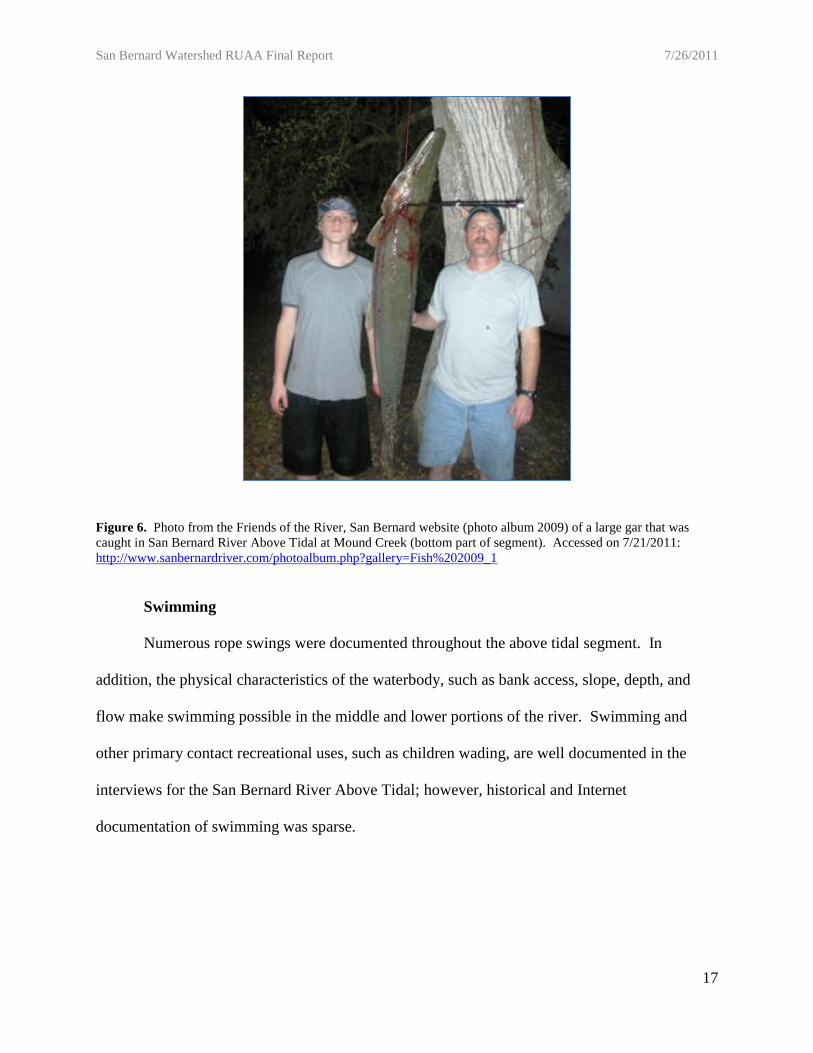
Figure 6. Photo from the Friends of the River, San Bernard website (photo album 2009) of a large gar that was
caught in San Bernard River Above Tidal at Mound Creek (bottom part of segment). Accessed on 7/21/2011:
http://www.sanbernardriver.com/photoalbum.php?gallery=Fish%202009_1
Swimming
Numerous rope swings were documented throughout the above tidal segment. In
addition, the physical characteristics of the waterbody, such as bank access, slope, depth, and
flow make swimming possible in the middle and lower portions of the river. Swimming and
other primary contact recreational uses, such as children wading, are well documented in the
interviews for the San Bernard River Above Tidal; however, historical and Internet
documentation of swimming was sparse.

San Bernard Watershed RUAA Final Report 7/26/2011 7/26/2011
18
Park Number Access Park Name Latitude Longitude River Mile
P1 Private Attwater National Wildlife Refuge 29.70593 -96.27126 78.9
P2 Public Bates Allen County Park 29.43146 -96.00957 39.5
P3 Private Camp Karankawa 29.14124 -95.728753 3.25
Parks
There are three parks directly adjacent to the San Bernard River Above Tidal; two of
which are not publicly accessible (Table 2 & Figure 7).
The Attwater Prairie Chicken National Wildlife Refuge is located on the upstream
portion of the San Bernard River Above Tidal at field survey site B2. The Refuge property is
directly adjacent to the river and provides access along the river through public roads and
footpaths, however, there is a refuge fence that lines the river preventing the public from directly
accessing the river through Refuge property.
Bates Allen Park, a Fort Bend County Park located in Kendelton, TX, was surveyed at
field survey site A12. The park covers over 200 acres directly adjacent to the San Bernard River
Above Tidal. Brandt Mannchen with the Houston Sierra Club describes the park as the perfect
location for beginning canoers and kayakers because of its width and slow current. He also
noted the opportunity to wade, fish, swim, bird, and nature study at the park. The park is a
favorite location for organized scouting and canoeing groups, supported by many on-line
postings (HASK 2010).
Camp Karankawa is a Bay Area Council Boy Scout camp that is located on the
downstream end of the San Bernard River Above Tidal. The Camp offers many amenities to
scout campers, including a waterfront area for canoeing and fishing.
Table 2. Parks located directly adjacent to the San Bernard River Above Tidal. Park number corresponds to Figure 7.

San Bernard Watershed RUAA Final Report 7/26/2011
19
Figure 7. Map of the parks that are directly adjacent to the San Bernard River Above Tidal. Park Number corresponds to Table 2.
San Bernard Watershed RUAA Final Report 7/26/2011
20
Site Reconnaissance Summary
Prospective sites were chosen based on public access and documented uses from the
stakeholder response to the request for information e-mail, which is included in Appendix 1. Site
suggestions were submitted to TCEQ as part of the Quality Assurance Plan’s (QAP) Monitoring
Plan, which was approved by TCEQ on January 19, 2011. An amended QAP including the
privately owned field survey sites and one public site was approved on July 5, 2011.
Initial reconnaissance surveys for the San Bernard River Above Tidal were conducted on
December 21, 2009 and January 6, 2010. A total of 30 prospective sites were visited, and of
these, 18 were chosen as field survey sites. An additional nine sites located on private property
were added to the site list to improve spatial coverage. Reconnaissance site tables and maps are
available in Appendix 9, Quality Assurance Plan and Monitoring Plans (QAP).
Initial reconnaissance surveys for Gum Tree Branch were conducted on June 22, 2010. A
total of 12 prospective sites were visited, and of these, three were chosen as field survey sites.
Reconnaissance site table and maps are available in Appendix 9, Quality Assurance Plan and
Monitoring Plans (QAP).
Initial reconnaissance surveys for West Bernard Creek were conducted on June 22 & 23,
2010. A total of 26 prospective sites were visited, and of these, 17 were chosen as field survey
sites. Reconnaissance site table and maps are available in Appendix 9, Quality Assurance Plan
and Monitoring Plans (QAP).
Methodologies
RUAA Survey Site Selection and Descriptions
The three streams assessed in this RUAA (San Bernard River Above Tidal, Gum Tree
Branch, and West Bernard Creek) flow through predominantly rural areas where the majority of

San Bernard Watershed RUAA Final Report 7/26/2011
21
the land is privately owned. The TCEQ recommends a target density of approximately three
survey sites per every five miles of stream (TCEQ, 2009). During our study, survey sites were
established in areas where the waterbody is accessible to the public and has the highest potential
for recreational use (road crossings, public lands/parks located near the waterbody, and
populated areas). These sites were chosen based on public access potential and also providing
sufficient spatial coverage throughout each assessment unit. In portions of the waterbody where
the recommended three sites per every five miles of stream was not possible, supplementary
information was gathered through coordination with local authorities in stakeholder meetings,
conducting interviews (Appendix 3), and using topographic maps and aerial photos to document
any additional potential access points (reconnaissance sites).
The San Bernard River Above Tidal Field Survey Sites
Due to the lack of public access points along the San Bernard River Above Tidal, a
sizeable effort was made to retrieve contact information from the county appraisal districts for all
landowners that own property directly adjacent to the river. Mailings describing the study and
requesting access permission to the San Bernard River Above Tidal were sent to 256 property
owners, and an additional 129 information-only packets (including interview forms) were mailed
to stakeholders when phone numbers were not available. A total of 27 field survey sites were
surveyed (Table 3 & Figure 9). Nine of the 27 field survey sites were located on private
property, of which the University of Houston-Clear Lake secured access in order to provide a
more spatially homogeneous scale to the field survey sites.
Extensive interviews were collected to help determine the types and frequency of contact
recreation occurring along the privately owned portions of the stream. These interviews resulted
in additional background information and confirmation that recreation was most likely to occur

San Bernard Watershed RUAA Final Report 7/26/2011
22
at sites identified in this study. Every effort was made for the interviewees to provide
recreational use information about the entire length of the segment, including areas other than the
selected sites in this RUAA. Topographic maps were used to provide the needed geographic
information about potential recreational opportunities and potential access points along the San
Bernard River Above Tidal. The topographic map and aerial imagery review resulted in site
selection for the reconnaissance site visits. Figure 8 was taken at field survey site 10, and is a
good representation of the general site conditions along the San Bernard River Above Tidal.
Figure 8. Picture of field survey site 10, showing the general representation of the physical conditions seen
on the San Bernard River Above Tidal (Segment 1302)

San Bernard Watershed RUAA Final Report 7/26/2011
23
Site #Site
TypeDescription Latitude Longitude
Approx.
River mile
A1 Public Bostik Rd @ San Bernard River 29.85483 -96.45535 106.0
B1 Private Dietzmann - Cat Spring @ San Bernard River 29.82687 -96.41480 97.9
A2 Public Cat Spring @ San Bernard River 29.82363 -96.37872 95.0
A3 Public FM 949 @ San Bernard River 29.82461 -96.34227 90.0
A4 Public Sealy Rd. @ San Bernard River 29.77978 -96.31506 86.0
A5 Public IH10 @ San Bernard River 29.74856 -96.29675 83.0
B2 Private Attwater NWR @ San Bernard River 29.70593 -96.27126 78.9
A6 Public FM 3013 @ San Bernard River 29.66065 -96.24348 74.7
A7 Public FM1093 @ San Bernard River 29.62238 -96.14528 67.0
A8 Public SH60 @ San Bernard River 29.60199 -96.09032 62.0
B3 Private Tihacek - East Bernard @ San Bernard River 29.56923 -96.06131 58.2
A9 Public US90A @ San Bernard River 29.53298 -96.05546 54.0
B4 Private Smith - East Bernard @ San Bernard River 29.51654 -96.05341 52.4
A10 Public FM2919 @ San Bernard River 29.49481 -96.02890 49.0
B5 Private Boettcher - East Bernard @ San Bernard River 29.48586 -96.05835 46.2
A11 Public US59 @ San Bernard River 29.43766 -96.01547 40.0
A12 Public Roberts Ln @ San Bernard River 29.43146 -96.00957 39.5
B6 Private Archer - East Bernard @ San Bernard River 29.41060 -95.97944 36.0
B7 Private Vallet - Needville @ San Bernard River 29.32611 -95.91935 29.2
A13 Public Tierra Grande Dr @ San Bernard River 29.34417 -95.94694 29.0
A14 Public FM442 @ San Bernard River 29.31321 -95.89314 24.0
B8 Private Henning - Boling @ San Bernard River 29.29210 -95.89062 22.2
B9 Private Moore - Guy @ San Bernard River 29.26330 -95.84851 15.8
A15 Public San Bernard Dr @ San Bernard River 29.25121 -95.83698 17.0
A16 Public FM1301 @ San Bernard River 29.16034 -95.76543 7.4
A17 Public FM1469 @ San Bernard River 29.15369 -95.76151 6.4
A18 Public Linnett Rd @ San Bernard River 29.13603 -95.71157 1.7
Table 3. Field survey sites for the Comprehensive RUAA Survey on the San Bernard River Above Tidal (Segment
1302) (see Figure 9).

San Bernard Watershed RUAA Final Report 7/26/2011
24
Figure 9. Comprehensive RUAA survey sites on the San Bernard River Above Tidal (Segment 1302) selections based on river mile/assessment units, accessibility,
and recreational features (see Table 3).

San Bernard Watershed RUAA Final Report 7/26/2011
25
Gum Tree Branch Field Survey Sites
The University of Houston-Clear Lake retrieved contact information from the county
appraisal districts for most landowners that own property directly adjacent to Gum Tree Branch.
Mailings describing the study and requesting access permission to Gum Tree Branch were sent to
the nine predominant property owners. A total of three field survey sites were surveyed (Table 4
& Figure 11). The University of Houston-Clear Lake was unable to find any landowner
interested in participating in the study, so no sites on private property were surveyed in this Basic
RUAA.
Interviews were solicited from the nine contacted landowners and during the public
meetings in order to gather supplemental information on what kind of recreation may occur
along Gum Tree Branch. Two interviews were completed by stakeholders suggesting that Gum
Tree Branch is not commonly used for recreation. Every effort was made for the interviewees to
provide recreational use information about the entire length of the waterbody, including areas
other than the selected sites in this RUAA. Topographic maps were used to provide the needed
geographic information about potential recreational opportunities and potential access points
along Gum Tree Branch. The topographic map and aerial imagery review resulted in site
selection for the reconnaissance site visits. Figure 10 was taken at field survey site 2, and is a
good representation of the general site conditions along Gum Tree Branch.

San Bernard Watershed RUAA Final Report 7/26/2011
26
Field
Survey
Site #
Description Latitude LongitudeApprox
river mile
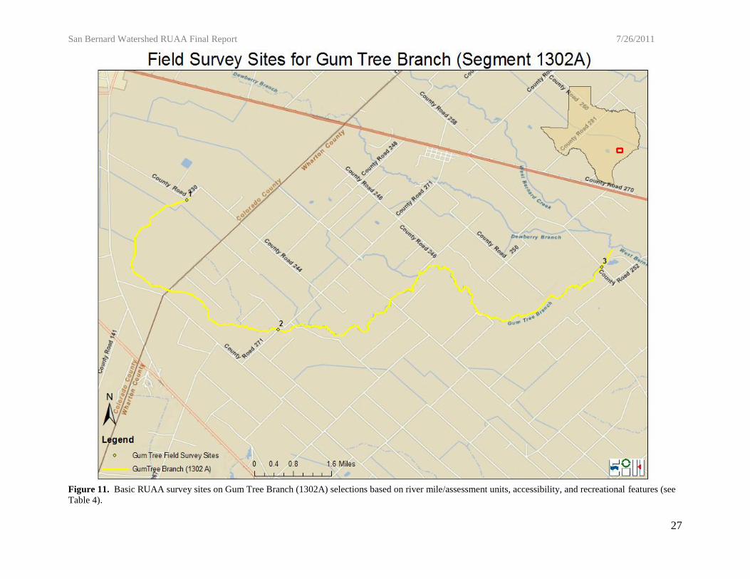
1 Hunt Rd @ Gum Tree Branch 29.54191 -96.30057 14.3
2 CR271 B @ Gum Tree Branch 29.50469 -96.27316 9.5
3 CR252 @ Gum Tree Branch 29.52269 -96.17594 0.4
Figure 10. Picture of field survey site 2, showing the general representation of the physical conditions seen
on Gum Tree Branch (1302A)
Table 4. Field survey sites for the Basic RUAA Survey on Gum Tree Branch (1302A) (see Figure 11).
San Bernard Watershed RUAA Final Report 7/26/2011
27
Figure 11. Basic RUAA survey sites on Gum Tree Branch (1302A) selections based on river mile/assessment units, accessibility, and recreational features (see
Table 4).
San Bernard Watershed RUAA Final Report 7/26/2011
28
West Bernard Creek Field Survey Sites
In attempts to gain supplemental access to West Bernard Creek, contact information was
retrieved from the county appraisal districts for all landowners that own property directly
adjacent to West Bernard Creek. Mailings describing the study and requesting access permission
to West Bernard Creek were sent to 86 property owners. Unfortunately, none of these property
owners were willing to participate in this study by allowing access to the creek through their
property. A total of 17 field sites were surveyed (Table 5 & Figure 13).
Interviews were collected from stakeholder mailings, public meetings, and from
individuals observed during the field surveys to help determine what kind of recreation occurs
along West Bernard Creek. These interviews resulted in additional background information and
confirmed that recreation was most likely to occur at the sites identified in this study. Every
effort was made for the interviewees to provide recreational use information about the entire
length of the waterbody, including areas other than the selected sites in this RUAA. The
topographic map and aerial imagery review resulted in site selection for the reconnaissance site
visits. Figure 12 was taken at field survey site 8, and is a good representation of the general site
conditions along West Bernard Creek.

San Bernard Watershed RUAA Final Report 7/26/2011
29
Field
Survey
Site #
Description Latitude Longitude
Approx.
river
mile
1 US90 @ West Bernard Creek 29.57760 -96.31158 40.2
2 FM1093 A @ West Bernard Creek 29.59033 -96.30036 39.0
3 Little Public Rd @ West Bernard Creek 29.59525 -96.28263 37.8
4 FM1093 B @ West Bernard Creek 29.59619 -96.27297 37.1
5 Colorado CR211 @ West Bernard Creek 29.57972 -96.23525 34.0
6 CR277 @ West Bernard Creek 29.57347 -96.21929 32.7
7 CR279 @ West Bernard Creek 29.56481 -96.20583 31.3
8 US90 B @ West Bernard Creek 29.55043 -96.19784 30.1
9 CR252 @ West Bernard Creek 29.52527 -96.16406 26.2
10 CR254 @ West Bernard Creek 29.49813 -96.14182 23.3
11 Wharton CR211 A @ West Bernard Creek 29.45521 -96.13750 19.0
12 CR213 @ West Bernard Creek 29.41330 -96.11169 13.8
13 CR215 @ West Bernard Creek 29.42495 -96.09166 11.7
14 SH60 @ West Bernard Creek 29.41519 -96.07856 10.3
15 US183 @ West Bernard Creek 29.40475 -96.07059 9.1
16 CR225 @ West Bernard Creek 29.38650 -96.02272 4.8
17 Boyett Drive @ West Bernard Creek 29.38495 -95.97991 1.4
Figure 12. Picture of field survey site 8, showing the general representation of the physical conditions seen
on West Bernard Creek (1302B)
Table 5. Field survey sites for the Basic RUAA Survey on West Bernard Creek (1302B) (see Figure 13).
San Bernard Watershed RUAA Final Report 7/26/2011
30
Figure 13. Basic RUAA survey sites on West Bernard Creek (1302B) selections based on river mile/assessment units, accessibility, and recreational features
(see Table 5).
San Bernard Watershed RUAA Final Report 7/26/2011
31
Sampling Methods
RUAAs are used to identify and assign attainable uses and criteria to individual water
bodies. Applicable uses and associated criteria are defined in the Texas Surface Water Quality
Standards (TSWQS). Until recently, Texas had two recreation use categories in the 2000
TSWQS: contact and noncontact recreation. In June 2010, these recreation use categories were
expanded to include additional categories: primary contact and secondary contact recreation (1 &
2). Primary contact recreation consists of recreational activities involving a significant risk of
ingestion of water including: wading by children, swimming, water skiing, diving, and surfing.
Secondary contact recreation 1 is considered water recreation activities not involving a
significant risk of water ingestion: including fishing, commercial and recreational boating, and
limited body contact incidental to shoreline activity. Secondary contact recreation 2 follows the
same definition as secondary contact recreation 1, except that it occurs less frequently due to (1)
physical characteristics of the waterbody and/or (2) limited public access.
According to TCEQ agency guidance, a comprehensive RUAA must be conducted on the
San Bernard River Above Tidal since it is a classified waterbody (Segment 1302), while a Basic
RUAA must first be completed on Gum Tree Branch (1302A) and West Bernard Creek (1302B),
as they are both unclassified water bodies. RUAA surveys must be conducted during the normal
warm season (air temperature ≥ 70°F) and periods when people would most likely use the
waterbody for contact recreational purposes (weekends, holidays, and summer). RUAA surveys
must also be conducted during optimal sampling conditions that are representative of the normal
flow conditions of the stream and are not storm-influenced. Throughout the sampling season of
2011, South Central Texas experienced drought conditions, which could have potentially
affected the amount and type of recreational uses observed during the field surveys for these

San Bernard Watershed RUAA Final Report 7/26/2011
32
three water bodies. RUAA field surveys for the San Bernard River Above Tidal watershed water
bodies were conducted between April 22nd and June 10th, 2011. More specific procedures can
be found in TCEQ’s RUAA Procedures Document, May 2009.
Field Survey Descriptions
An RUAA field survey begins with marking off a 300 meter (m) reach of the waterway,
and flagging every 30m. Sites with public accessibility limitations may not be fully assessed in
this way. In instances such as these, a laser range finder was used to document the length of the
stream reach that could be observed. A flow measurement was then taken where possible within
the 300m stream reach. If the waterbody was wadeable, a depth measurement was taken every
30m and width measurements were taken at the widest, narrowest, and average width points
within the 300m reach. If the waterbody was not wadeable, ten representative width
measurements were taken throughout the waterbody. Pictures were taken to document the
survey at 30, 150, and 300 meters facing upstream, right bank, downstream, and left bank (right
and left bank determined facing downstream). Air temperature, water temperature, and secchi
depth were also recorded at an easily accessible location. Finally, the RUAA datasheets were
completed to document any recreational uses, signs of recreational use, impeding conditions, or
other field notes taken during the field survey.
Due to impediments affecting stream access, complete field survey methods were not
possible at some locations on the assessed water bodies. Impediments to stream access, such as
steep banks and water depth exceeding 1.5 meters, at times, limited the field survey team’s
ability to survey the complete 300 meter stretch of stream. In each case where this was a factor,
the impediments were documented on the field data sheet and pictures of these conditions were
San Bernard Watershed RUAA Final Report 7/26/2011
33
also taken. Specific impediments causing access constraints for each site can be found in
Appendices 2 and 5.
Interviews
Interviews were conducted during field survey visits on both the unclassified and
classified segments whenever possible (Appendix 3). In-person interviews were performed with
interviewees located in close proximity to the waterbody and, in some cases, adjacent
land/homeowners. Interview forms were mailed to a total of 480 landowners in the watershed
for all three waterbodies combined. Other stakeholders were interviewed via telephone for the
San Bernard River Above Tidal (Appendix 3). The Environmental Institute of Houston’s
Interview Protocol Guideline is attached as Appendix 4.
Results
The San Bernard River Above Tidal RUAA Results
The 107 miles of the San Bernard River Above Tidal were evaluated using a total of 27
field surveys. Eighteen sites were located on public property and were surveyed twice. Nine
sites were located on private property and were surveyed once in order to document the physical
parameters relating to recreational use potential, as well as interviews with the landowners. Field
survey visits were completed between April 22nd and June 10th, 2011. All field data sheets are
attached (Appendix 2).
Physical Evaluation and Flow
During the RUAA surveys, the air temperatures fell within the range of acceptable
temperatures for sampling described in the TCEQ procedures manual (Table 6). The average
thalweg depth of the San Bernard River Above Tidal was greater than 0.9 meters and the average

San Bernard Watershed RUAA Final Report 7/26/2011
34
width was 14.7 meters. The average Secchi Tube reading taken at the field survey sites was 0.4
meters (Table 6). The average flow for the segment based on measurements taken at accessible
sites was 8.5cfs. The stream type recorded throughout the segment was intermittent with
perennial pools in the upstream portion of the waterbody, and perennial from site A-9 to the end
of the segment. The San Bernard River Above Tidal riparian zone can be categorized generally
as forested (Table 7). The dominant substrate observed within the segment was either sand in
the upstream or mud/clay in the downstream portions of the watershed.
Surrounding Conditions that Impede Recreation and Channel Obstructions
Impediments to stream recreation and channel obstructions on the San Bernard River
Above Tidal were recorded at the field survey site visits and include: steep slopes, log jams,
thick vegetation, private property, and fences. The San Bernard River Above Tidal has limited
public access due to the large amount of privately owned land surrounding the river. A complete
listing of the documented stream recreational use impediments and their locations can be found
in Table 9, and Appendix 8.
Recreational Uses
Uses observed from all combined site visits include: kayaking, boating, fishing, standing,
walking, and jogging/running (Table 8). A total of ten people were observed carrying out
secondary contact recreation activities on the San Bernard River Above Tidal. The dominant
secondary contact recreation activity observed was kayaking. Various non-contact activities were
recorded, as well as evidence of recreation. Rope swings were found at field survey site numbers
A13, A14, A17, and A18. Fishing tackle was found at nine of the field survey sites. Foot
paths/prints were documented at 14 of the field survey sites. Remnants of kids’ play (toys) were
found at field survey site number A17.
San Bernard Watershed RUAA Final Report 7/26/2011
35
Interviews
During the Comprehensive RUAA on the San Bernard River Above Tidal (Segment
1302), a total of 119 individuals agreed to participate in the interview. Of the 119 total, 24 were
interviewed in person, 25 by mail, and 70 by phone. A total of 96 out of the 119 interviewed
answered yes to the question “Are you familiar with the San Bernard River Above Tidal?” Of
those, 49 had personally used the stream for recreation, 68 had observed recreation activities, and
62 had heard about recreation on the San Bernard River Above Tidal. The total number of years
that interviewees were familiar with the San Bernard River Above Tidal watershed was over
1,900 man-years.
The types of recreational uses documented by interviews included the following primary
contact recreation activities: swimming, wading-children, tubing, and water skiing (Tables 8 &
9). Secondary contact uses documented by interviews included: wading-adults, rafting, boating,
kayaking, canoeing, and fishing. Non-contact uses included: trapping, hunting, walking/hiking,
and wildlife watching. Figure 14 depicts the approximate locations of observed recreational
uses. Appendix 8-A provides an electronic supplement which includes a complete depiction of
the observed uses, physical evidence of uses, and responses to interviews that provided data
based on personal experiences, witnessed uses, hear-say uses, and impediments.
San Bernard Watershed RUAA Final Report 7/26/2011
36
Site # Site Description
Avg Air
Temp (C)
Avg Water
Temp (C)
Avg Secchi
(m)
Avg Stream
Flow (cfs)
Avg Depth
(m)
Avg Width
(m)
A1 Bostik Rd. @ San Bernard River 32.0 * 0.15 0.00 0.34 (pools) 3.25 (pools)
B1 Dietzman-cat spring @ San Bernard River 29.0 26.0 0.26 0.00 0.36 (pools) 5.8 (pools)
A2 Cat Spring @ San Bernard River 29.1 24.5 0.50 0.00 0.43 (pools) 6.03 (pools)
A3 Fm 949 @ San Bernard River 30.6 27.0 0.71 0.00 0.44 (pools) 3.64 (pools)
A4 Sealy Rd @ San Bernard River 29.7 25.0 1.01 0.00 0.92 (pools) 14.35 (pools)
A5 IH 10 @ San Bernard 30.4 25.5 1.84 0.00 0.30 (pools) 3.71 (pools)
B2 Attwater NWR @ San Bernard River 27.2 **** **** 0.00 **** ****
A6 FM 3013 @ San Bernard River 28.4 24.8 0.40 0.00 1.02 (pools) 21.59 (pools)
A7 Fm 1093 @ San Bernard River 30.1 ** ** 0.00 ** **
A8 SH 60 @ San Bernard River 30.0 28.0 0.54 0.00 0.71 (pools) 12.6 (pools)
B3 Tichacek-East Bernard @ San Bernard River 31.0 ** ** 0.00 ** **
A9 US90A @ San Bernard River 28.7 24.0 0.18 6.60 0.81 11.8
B4 Smith-East Bernard @ San Bernard River 32.7 26.0 0.61 7.77 0.59 8.0
A10 FM 2919 @ San Bernard River 32.0 25.0 0.46 5.60 0.80 19.1
B5 Boettcher-East Bernard @ San Bernard River 38.6 26.0 0.33 *** >1.4 12.9
A11 US 59 @ San Bernard River 32.8 25.0 0.24 6.50 >1.25 16.5
A12 Roberts Ln. @ San Bernarard River 26.7 26.4 0.26 *** >1.4 52.0
B6 Archer-East Bernard @ San Bernard River 34.8 31.0 0.30 <1.0 0.42 4.6
B7 Vallet-Needville @ San Bernard River 29.0 27.0 0.14 31.79 0.91 6.1
A13 Tierra brande Dr. @ San Bernard River 28.0 23.0 0.17 *** >1.4 17.3
A14 FM 442 @ San Bernard River 30.7 25.0 0.20 37.16 >1.23 15.4
B8 Henning-Boling @ San Bernard River 36.2 28.0 0.32 8.13 >1.4 17.2
B9 Moore-Guy @ San Bernard River 32.7 28.0 0.31 15.60 1.26 6.1
A15 San Bernard Dr @ San Bernard River 28.9 26.0 0.42 *** >1.21 16.4
A16 FM 1301 @ San Bernard River 30.2 24.0 0.23 51.85 >1.22 17.5
A17 FM 1469 @ San Bernard River 29.6 26.8 0.51 *** >1.4 24.3
A18 Linnett Rd. @ San Bernard River 28.0 27.0 0.28 *** >1.4 36.8
Total Average 30.6 26.0 0.4 8.5 >0.9 14.7
Table 6. Average physical parameters from the Comprehensive RUAA two field surveys conducted on the San Bernard River Above Tidal (Segment 1302) * =
not taken due to sampler error, ** = site dry, *** = Too deep, no flow taken, **** = no water access.

San Bernard Watershed RUAA Final Report 7/26/2011
37
Site # Site Description
Left Bank
Riparian Zone Right Bank Riparian Zone
Ease of Bank Access to
Water
Dominant Primary
Substrate
A1 Bostik Rd. @ San Bernard River Forest Forest Easy Sand/Mud/Clay
B1 Dietzman-cat spring @ San Bernard River Forest Forest Moderately Difficult Sand
A2 Cat Spring @ San Bernard River Forest Forest Easy/Moderatly Easy Sand
A3 Fm 949 @ San Bernard River Forest Forest Easy Sand
A4 Sealy Rd @ San Bernard River Forest Forest Easy Sand
A5 IH 10 @ San Bernard Forest Forest Easy Silt/Sand
B2 Attwater NWR @ San Bernard River Forest Shrub Easy Sand
A6 FM 3013 @ San Bernard River Shrub Shrub Easy/Moderately Easy Sand
A7 Fm 1093 @ San Bernard River Forest Forest Easy Sand
A8 SH 60 @ San Bernard River Forest Forest Easy/Moderately Easy Sand
B3 Tichacek-East Bernard @ San Bernard River Forest Forest Moderately Difficult Sand
A9 US90A @ San Bernard River Forest Forest Moderately Easy Sand/Mud/Clay
B4 Smith-East Bernard @ San Bernard River Forest Forest Easy Sand
A10 FM 2919 @ San Bernard River Forest Forest Moderately Easy Sand/Mud/Clay
B5 Boettcher-East Bernard @ San Bernard River Forest Forest Moderately Easy Mud/Clay
A11 US 59 @ San Bernard River Forest Forest Moderately Easy/Difficult Silt/Mud/Clay
A12 Roberts Ln. @ San Bernarard River Forest Forest Easy Sand/Mud/Clay
B6 Archer-East Bernard @ San Bernard River Forest Mowed/Maintained Easy Mud/Clay
B7 Vallet-Needville @ San Bernard River Forest Forest Moderately Easy Mud/Clay
A13 Tierra brande Dr. @ San Bernard River Forest Forest Moderately Easy/Difficult Mud/Clay
A14 FM 442 @ San Bernard River Forest Forest Moderately Easy Mud/Clay
B8 Henning-Boling @ San Bernard River Forest Forest Moderately Easy Mud/Clay
B9 Moore-Guy @ San Bernard River Forest Forest Moderately Difficult Mud/Clay
A15 San Bernard Dr @ San Bernard River Forest Forest Moderately Easy Mud/Clay
A16 FM 1301 @ San Bernard River Forest Forest Moderately Easy/Difficult Mud/Clay
A17 FM 1469 @ San Bernard River Forest Forest Moderately difficult Sand/Mud/Clay
A18 Linnett Rd. @ San Bernard River Forest Forest Moderately Easy Mud/Clay
Table 7. Physical Characteristics of Riparian Zone and Dominant substrate of the field survey sites sampled during the Comprehensive RUAA on the San
Bernard River Above Tidal (Segment 1302)

San Bernard Watershed RUAA Final Report 7/26/2011
38
Table 8. Recreational uses observed and interviewed documented by number of observed occurrences for the San Bernard River Above Tidal (Segment 1302)
collected during the Comprehensive RUAA.
Personal Use Witnessed Hearsay
Swimming 17 14 11 42
Wading - Children 6 3 5 14
Tubing 3 3
Water Skiing 2 2 1 5
Wading - Adults 8 4 5 17
Rafting 1 1 2 4
Boating 2 6 13 10 31
Kayaking/Canoeing 2 18 25 18 63
Fishing 7 35 51 46 139
Hunting 7 7 13 27
Trapping 2 3 2 7
Walking/Hiking 1 3 2 6
Jogging/Running 1 1 2
Fossil Hunting 1 1
Motorcycle/ATV 4 4
Horseback Riding 1 1
Camping 2 1 3
Wildlife Watching 1 2 3 6
Photography 1 1
Standing/Sitting 5 1 1 7
Non
Field Survey
Observations
InterviewsTotal
Types of recreation
1°
2°

San Bernard Watershed RUAA Final Report 7/26/2011
39
Observed Recreational Uses on the San Bernard River, Above Tidal
Figure 14. Comprehensive RUAA survey sites on the San Bernard River Above Tidal (Segment 1302) selections based on river mile/assessment units,
accessibility, and recreational features. Constructed from field observations. Locations are approximate. See Appendix 8-A for an interactive Google Earth map
depicting exact locations of uses, impediments, and evidence.

San Bernard Watershed RUAA Final Report 7/26/2011
40
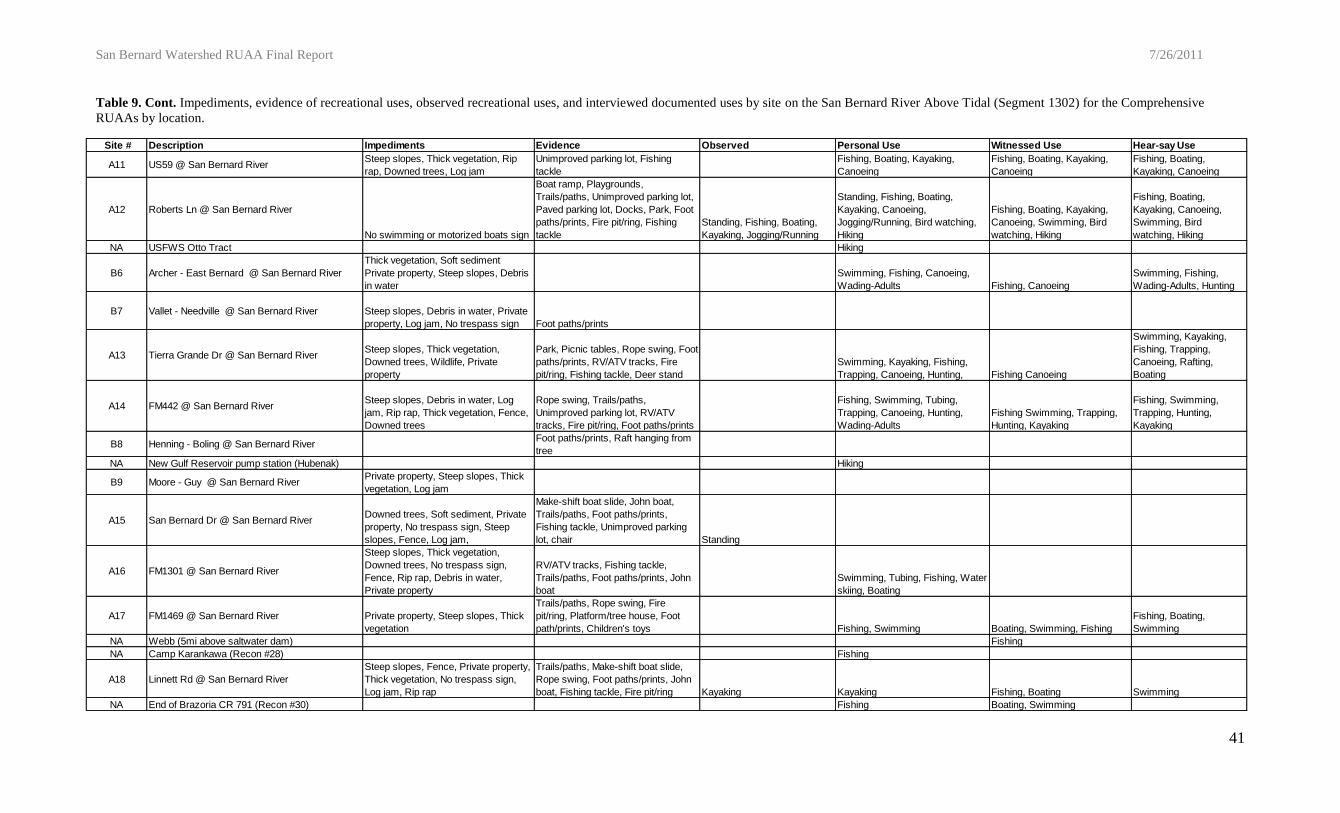
Site # Description Impediments Evidence Observed Personal Use Witnessed Use Hear-say Use
A1 Bostik Rd @ San Bernard RiverFence, Steep slopes, Thick
vegetation, Culverts, Private
property
NAEnd of Dunlavy Rd (Ellison)
Swimming, Fishing, Wading-
Children, Wading-Adults Fishing
Wading-Children, Wading-
Adults, Hunting
B1 Dietzmann - Cat Spring @ San Bernard RiverSteep slopes, Thick vegetation,
Private property, Fence, Low
water crossing
Trails/pathsSwimming, Fishing, Hunting,
Wading-Children, Wading-Adults
Fishing, Hunting, Wading-
Children
Fishing, Hunting,
Trapping, Wading-
Children, Wading-Adults
A2 Cat Spring @ San Bernard RiverPrivate property, Steep slopes,
Thick vegetationRV/ATV tracks, Graffiti
Swimming, Tubing, Fishing,
Wading-Children, Wading-Adults
Swimming, Tubing, Wading-
ChildrenSwimming, Tubing
A3 FM 949 @ San Bernard RiverFence, Thick vegetation, Private
property, Steep slopesRV/ATV tracks
A4 Sealy Rd. @ San Bernard RiverDebris in channel, Thick
vegetation, Low bridge, Private
property, Fence
Swimming, Wading-ChildrenSwimming, Sitting, Wading-
Children, FishingSwimming, Fishing
A5 IH10 @ San Bernard River Steep slopes Chair
B2 Attwater NWR @ San Bernard River Fence, Private property Bird watching, Photography Wading-Adults
A6 FM 3013 @ San Bernard RiverFence, No trespass sign, Private
property, Steep slopes
Foot paths/prints, Graffiti, Fishing
tackle, Unimproved parking lotKayaking, Canoeing
NAKaechele Ranch (Recon #10)
Fishing, ATV riding, Hiking,
Wading-Adults
A7 FM1093 @ San Bernard River Fence, Private propertyTrails/paths, RV/ATV tracks, Fire
pit/ring, Shotgun shells
NA Parma-Brandt Rd (Turner) ATV riding, Horseback Riding
A8 SH60 @ San Bernard River Trails/paths, RV/ATV tracks, Fire
pit/ring, Fishing tackleStanding
Kayaking, Fishing, Wading-
Children, Wading-Adults
Kayaking, Fishing, Canoeing,
Wading-Adults, SwimmingFossil-hunting
NA End of Wharton CR 268 (Minks) Fishing, Boating, Camping
B3 Tihacek - East Bernard @ San Bernard RiverFence, Private property, No
trespass sign, Log jamTrails/paths, Deer stand
NA Sycamore Circle (Rives) Fishing Fishing
A9 US90A @ San Bernard River Rip rap, Debris in channel, Log
jam
Fire pit/ring, RV/ATV tracks,
Graffiti, Foot paths/printsSwimming, Fishing, Hunting
Fishing, Hunting, Motorcycle
ridingFishing
B4 Smith - East Bernard @ San Bernard RiverSteep slopes, Downed trees,
Debris in water, Private propertyTrails/paths, Foot paths/prints
Fishing, Hunting, Wading-Children,
Wading-Adults
Fishing, Hunting, Wading-
Children, Wading-Adults
Hunting, Fishing, Wading-
Adults, Wading-Children
NA End of Hargis St (Recon #14) Fishing Fishing Hunting
A10 FM2919 @ San Bernard River Steep slopes, Thick vegetation,
Log jamFoot paths/prints, Fishing tackle
B5 Boettcher - East Bernard @ San Bernard RiverPrivate property, Fence, Thick
vegetation, Log jamFoot paths/prints
NA County Road 208 (Hlavinka) Canoeing
Table 9. Impediments, evidence of recreational uses, observed recreational uses, and interviewed documented uses by site on the San Bernard River Above Tidal (Segment 1302) for the Comprehensive RUAAs by
location. (Table Continued on next page)
San Bernard Watershed RUAA Final Report 7/26/2011
41
Site # Description Impediments Evidence Observed Personal Use Witnessed Use Hear-say Use
A11 US59 @ San Bernard RiverSteep slopes, Thick vegetation, Rip
rap, Downed trees, Log jam
Unimproved parking lot, Fishing
tackle
Fishing, Boating, Kayaking,
Canoeing
Fishing, Boating, Kayaking,
Canoeing
Fishing, Boating,
Kayaking, Canoeing
A12 Roberts Ln @ San Bernard River
No swimming or motorized boats sign
Boat ramp, Playgrounds,
Trails/paths, Unimproved parking lot,
Paved parking lot, Docks, Park, Foot
paths/prints, Fire pit/ring, Fishing
tackle
Standing, Fishing, Boating,
Kayaking, Jogging/Running
Standing, Fishing, Boating,
Kayaking, Canoeing,
Jogging/Running, Bird watching,
Hiking
Fishing, Boating, Kayaking,
Canoeing, Swimming, Bird
watching, Hiking
Fishing, Boating,
Kayaking, Canoeing,
Swimming, Bird
watching, Hiking
NA USFWS Otto Tract Hiking
B6 Archer - East Bernard @ San Bernard River
Thick vegetation, Soft sediment
Private property, Steep slopes, Debris
in water
Swimming, Fishing, Canoeing,
Wading-Adults Fishing, Canoeing
Swimming, Fishing,
Wading-Adults, Hunting
B7 Vallet - Needville @ San Bernard River Steep slopes, Debris in water, Private
property, Log jam, No trespass sign Foot paths/prints
A13 Tierra Grande Dr @ San Bernard RiverSteep slopes, Thick vegetation,
Downed trees, Wildlife, Private
property
Park, Picnic tables, Rope swing, Foot
paths/prints, RV/ATV tracks, Fire
pit/ring, Fishing tackle, Deer stand
Swimming, Kayaking, Fishing,
Trapping, Canoeing, Hunting, Fishing Canoeing
Swimming, Kayaking,
Fishing, Trapping,
Canoeing, Rafting,
Boating
A14 FM442 @ San Bernard RiverSteep slopes, Debris in water, Log
jam, Rip rap, Thick vegetation, Fence,
Downed trees
Rope swing, Trails/paths,
Unimproved parking lot, RV/ATV
tracks, Fire pit/ring, Foot paths/prints
Fishing, Swimming, Tubing,
Trapping, Canoeing, Hunting,
Wading-Adults
Fishing Swimming, Trapping,
Hunting, Kayaking
Fishing, Swimming,
Trapping, Hunting,
Kayaking
B8 Henning - Boling @ San Bernard RiverFoot paths/prints, Raft hanging from
tree
NA New Gulf Reservoir pump station (Hubenak) Hiking
B9 Moore - Guy @ San Bernard RiverPrivate property, Steep slopes, Thick
vegetation, Log jam
A15 San Bernard Dr @ San Bernard RiverDowned trees, Soft sediment, Private
property, No trespass sign, Steep
slopes, Fence, Log jam,
Make-shift boat slide, John boat,
Trails/paths, Foot paths/prints,
Fishing tackle, Unimproved parking
lot, chair Standing
A16 FM1301 @ San Bernard River
Steep slopes, Thick vegetation,
Downed trees, No trespass sign,
Fence, Rip rap, Debris in water,
Private property
RV/ATV tracks, Fishing tackle,
Trails/paths, Foot paths/prints, John
boat
Swimming, Tubing, Fishing, Water
skiing, Boating
A17 FM1469 @ San Bernard River Private property, Steep slopes, Thick
vegetation
Trails/paths, Rope swing, Fire
pit/ring, Platform/tree house, Foot
path/prints, Children's toys Fishing, Swimming Boating, Swimming, Fishing
Fishing, Boating,
Swimming
NA Webb (5mi above saltwater dam) Fishing
NA Camp Karankawa (Recon #28) Fishing
A18 Linnett Rd @ San Bernard River
Steep slopes, Fence, Private property,
Thick vegetation, No trespass sign,
Log jam, Rip rap
Trails/paths, Make-shift boat slide,
Rope swing, Foot paths/prints, John
boat, Fishing tackle, Fire pit/ring Kayaking Kayaking Fishing, Boating Swimming
NA End of Brazoria CR 791 (Recon #30) Fishing Boating, Swimming
Table 9. Cont. Impediments, evidence of recreational uses, observed recreational uses, and interviewed documented uses by site on the San Bernard River Above Tidal (Segment 1302) for the Comprehensive
RUAAs by location.
San Bernard Watershed RUAA Final Report 7/26/2011
42
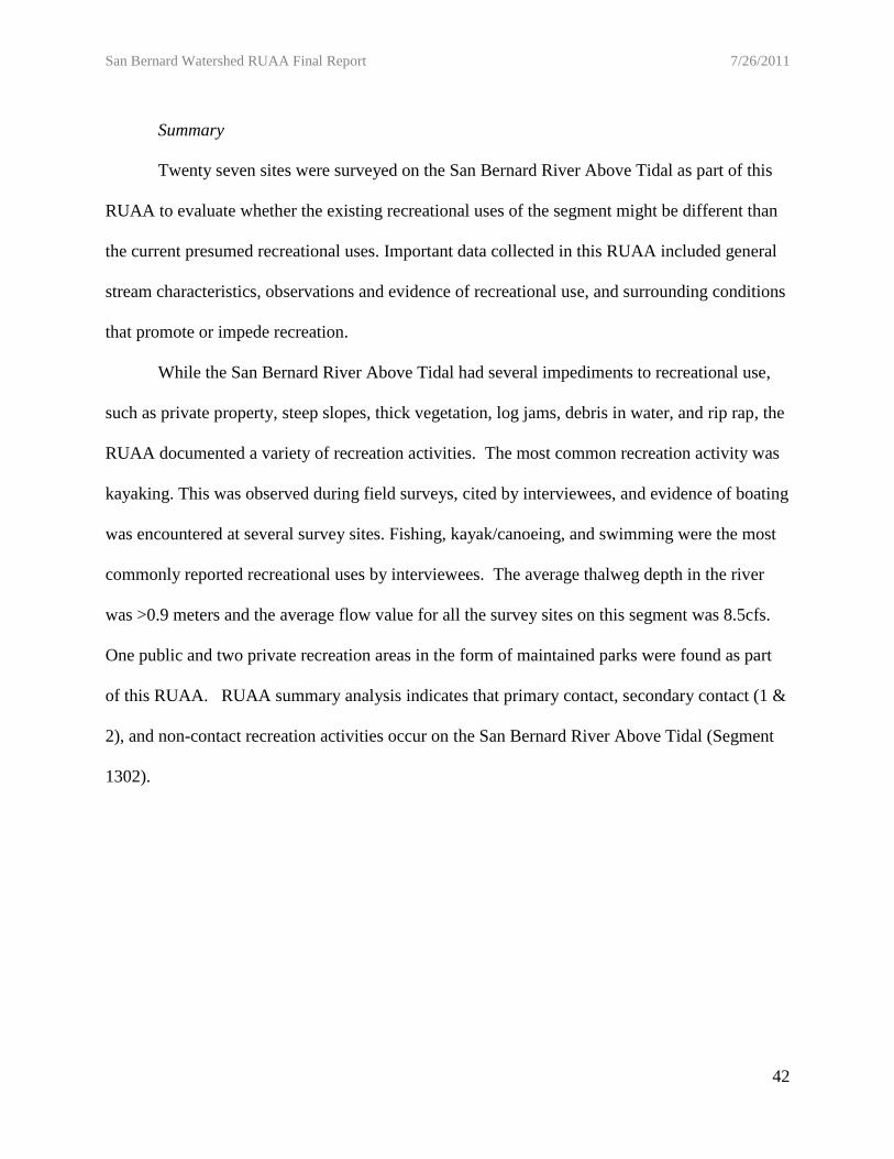
Summary
Twenty seven sites were surveyed on the San Bernard River Above Tidal as part of this
RUAA to evaluate whether the existing recreational uses of the segment might be different than
the current presumed recreational uses. Important data collected in this RUAA included general
stream characteristics, observations and evidence of recreational use, and surrounding conditions
that promote or impede recreation.
While the San Bernard River Above Tidal had several impediments to recreational use,
such as private property, steep slopes, thick vegetation, log jams, debris in water, and rip rap, the
RUAA documented a variety of recreation activities. The most common recreation activity was
kayaking. This was observed during field surveys, cited by interviewees, and evidence of boating
was encountered at several survey sites. Fishing, kayak/canoeing, and swimming were the most
commonly reported recreational uses by interviewees. The average thalweg depth in the river
was >0.9 meters and the average flow value for all the survey sites on this segment was 8.5cfs.
One public and two private recreation areas in the form of maintained parks were found as part
of this RUAA. RUAA summary analysis indicates that primary contact, secondary contact (1 &
2), and non-contact recreation activities occur on the San Bernard River Above Tidal (Segment
1302).

San Bernard Watershed RUAA Final Report 7/26/2011
43
Gum Tree Branch RUAA Results
The 15 miles of Gum Tree Branch were evaluated using a total of three field surveys.
Field survey visits were completed on May 15th and 21st, 2011. All field data sheets are
attached (Appendix 2).
Physical Evaluation and Flow
During the RUAA surveys, the air temperatures fell within the range of acceptable
temperatures for sampling described in the TCEQ procedures manual (Table 10). The average
thalweg depth of Gum Tree Branch was 0.56 meters and the average width was 6.4 meters. The
average Secchi Tube reading taken at the field survey sites was 0.13 meters (Table 10). The
average flow for the waterbody based on measurements taken at accessible sites was 10.9cfs.
The stream type recorded at site one was intermittent with perennial pool and at site two and
three it was perennial. Gum Tree Branch riparian zone was categorized as row crop, shrub
dominated corridor, and forested from site 1 to site 3, respectively (Table 11). The dominant
substrate throughout the waterbody was generally composed of mud/clay.
Surrounding Conditions that Impede Recreation and Channel Obstructions
Impediments to stream recreation and channel obstructions on Gum Tree Branch were
recorded at the field survey site visits and include: debris, private property, steep slopes, fences,
culvert, and wildlife. Gum Tree Branch has very limited public access due to the privately
owned land surrounding the waterbody. A complete listing of the documented stream
recreational use impediments and their locations can be found in Table 12, and Appendix 8-B.

San Bernard Watershed RUAA Final Report 7/26/2011
44
Recreational Uses
Throughout the reconnaissance as well as field survey site visits, no recreational use of
Gum Tree Branch was documented. A deer blind, as well as, bullet casings were observed at
field survey site 3. Water depth and ease of bank access at all three sites along Gum Tree Branch
do not physically restrict the potential for recreational use on this waterbody.
Interviews
During the Basic RUAA on Gum Tree Branch (1302A), a total of two individuals
completed an interview form, neither of which reported any recreational use on the waterbody.
There were no recreational uses observed by field staff, and there was no evidence of
recreational use observed during the field surveys. Please see Appendix 8, an electronic
supplement for the complete depiction of the observed uses, evidence of uses, interviewed uses
in the form of personal uses, witnessed use, and hear-say use, and impediments.

San Bernard Watershed RUAA Final Report 7/26/2011
45
Table 10. Average physical parameters from the basic RUAA field surveys conducted on Gum Tree Branch (1302A)
Table 11.Physical Characteristics of Riparian Zone and Dominant Substrate of the field survey sites sampled during the basic RUAA on Gum Tree Branch
(1302A)
Site # Site Description
Air Temp
(°C)Water
Temp(°C)
Secchi
(m)
Average
Depth
(m)
Average
Width
(m)
Stream
Flow (cfs)
1 Hunt Rd. @ Gum Tree Branch 30.0 26 NA 0.54 2.1 0.00
2 CR 271B @ Gum Tree Branch 23.0 20 0.15 0.63 10.0 11.47
3 CR 252 @ Gum Tree Branch 22.5 20 0.11 0.50 7.0 21.17
Total Average 25.2 22 0.13 0.56 6.4 10.88
Site # Site Description Stream Type Left Bank Riparian Zone Right Bank Riparian Zone
Ease of
Bank
Access
Dominant
Primary
Substrate
1 Hunt Rd. @ Gum Tree Branch Intermittent w/ perennial pools Row Crops (rice fields) Row Crops (rice fields) Easy Mud/Clay
2 CR 271B @ Gum Tree Branch Perennial Shrub-Dominated corrdidor Shrub-Dominated corrdidor Easy Mud/Clay
3 CR 252 @ Gum Tree Branch Perennial Forest Forest Easy Mud/Clay

San Bernard Watershed RUAA Final Report 7/26/2011
46
Table 12. Impediments and evidence of recreational uses by site on Gum Tree Branch (1302A) for the basic RUAA
by location.
Summary
Three sites were surveyed on Gum Tree Branch as part of this RUAA to evaluate whether
the existing and/or attainable recreational uses of the waterbody might be different than the
current presumed recreational uses. Important data collected in this RUAA included general
stream characteristics, observations and evidence of recreational use, and surrounding conditions
that promote or impede recreation.
Gum Tree Branch had several impediments to recreational use such as debris, private
property, steep slopes, fences, culvert, and wildlife. There was no active recreational use, nor
any evidence of recreational use observed during the field surveys. The thalweg depth on
average was 0.56 meters and the average flow value for all the survey sites was 10.88cfs. RUAA
summary analysis indicates that with the limited information collected as part of this basic
RUAA no recreation activities occur on Gum Tree Branch (1302A).
Field Survey
Site #Description
Impediments Evidence
1 Hunt Rd @ Gum Tree BranchWildlife (alligators), Stagnant pooled
water, private property, culvert
2 CR271 B @ Gum Tree Branch
Fence, Steep slopes, Low water
bridge, Debris in water, Garbage,
Wildlife (snakes)
3 CR252 @ Gum Tree BranchSteep slopes, Thick vegetation, Debris
in water, Wildlife (snakes), Garbage
Deer blind,
Bullet casings

San Bernard Watershed RUAA Final Report 7/26/2011
47
West Bernard Creek RUAA Results
The 40 miles of West Bernard Creek were evaluated using a total of 17 field surveys.
Field survey visits were completed between May 7th and 14th, 2011. All field data sheets are
attached (Appendix 2).
Physical Evaluation and Flow
During the RUAA surveys, the air temperatures fell within the range of acceptable
temperatures for sampling described in the TCEQ procedures manual (Table 13). The average
thalweg depth of West Bernard Creek was 0.7 meters and the average width was 10.2 meters.
The average secchi tube reading taken at the field survey sites was 0.2 meters (Table 13). The
average flow for the waterbody based on measurements taken at accessible sites was 28.8cfs.
The most common stream type recorded throughout the waterbody was either perennial or
intermittent with perennial pools recorded at sites 1 and 2. West Bernard Creek riparian zone
can be generally categorized as forested (Table 14). The dominant substrate throughout the
waterbody was generally composed of mud/clay.
Surrounding Conditions that Impede Recreation and Channel Obstructions
Impediments to stream recreation and channel obstructions on West Bernard Creek were
recorded at the field survey site visits and include: steep slopes, fences, thick vegetation, debris
in channel, log jams, and wildlife. A complete listing of the documented stream recreational use
impediments and their locations can be found in Table 16, and Appendix 8-C.

San Bernard Watershed RUAA Final Report 7/26/2011
48
Recreational Uses
There was only one recreational use observed during the field surveys, which occurred at
site 14 and involved a father and son driving up to the site to check their jug lines (Table 15).
Various evidence of recreation was recorded on the downstream portion of the waterbody.
Fishing tackle was found at five of the field survey sites. Foot paths/prints were documented at
three of the field survey sites.
Interviews
During the basic RUAA on West Bernard Creek (1302B), a total of 86 information
packets were mailed to landowners with property adjacent to the waterbody. In these
information packets, interview forms were included. Interviews were also solicited at field
survey sites and at the public meeting. A total of 11 interviews were completed. Of the 11, one
interview was completed in person at field survey site 14; while the rest were mailed into UHCL.
A total of nine of the 11 interviewed answered yes to the question “Are you familiar with West
Bernard Creek?” Of those, six had personally used the stream for recreation, four had observed
recreation activities, and four had heard about recreation on West Bernard Creek.
The types of recreational uses documented by interviews included the following primary
contact recreation activities: swimming, tubing, and wading-children (Table 15 & 16).
Secondary contact uses documented by interviews included: wading-adults, boating, kayaking,
and fishing. Non-contact uses included: trapping and hunting. Please see Appendix 8, an
electronic supplement for the complete depiction of the observed uses, evidence of uses,
interviewed uses in the form of personal uses, witnessed use, and hear-say use, and impediments.

San Bernard Watershed RUAA Final Report 7/26/2011
49
Table 13. Average physical parameters from the basic RUAA field surveys conducted on West Bernard Creek (1302B) * = average width and depth of pools.
Site # Site Description
Air Temp
(°C)
Water
Temp
(°C)
Secchi
(m)
Average
Depth
(m)
Average
Width
(m)
Stream
Flow
(cfs)
1 US90 at West Bernard Creek 29.0 19.5 0.30 0.13 2.2 0.01
2 FM1093A at West Bernard Creek 29.0 21.0 0.15 * 0.14 * 19 0.00
3 Little Public Road at West Bernard Creek 30.5 20.3 0.18 0.23 5.0 0.48
4 FM1093 B at West Bernard Creek 32.0 24.0 0.13 0.26 2.8 1.30
5 Colorado CR211 at West Bernard Creek 33.0 26.0 0.22 0.40 4.2 5.01
6 CR277 at West Bernard Creek 28.0 25.0 0.47 0.30 4.7 5.14
7 CR279 at West Bernard Creek 31.0 23.0 0.32 0.42 4.0 2.64
8 US90B @ West Bernard Creek 29.0 24.0 0.52 0.41 4.5 3.47
9 CR 252 @ West Bernard Creek 29.0 24.0 0.05 0.65 10.0 14.35
10 CR 254 @ West Bernard Creek 33.0 26.0 0.13 0.72 9.5 19.68
11 CR 211A @ West Bernard Creek 32.0 26.0 0.01 0.82 11.0 29.33
12 CR 213 @ West Bernard Creek 31.1 22.0 0.13 >1.4 49.0 36.83
13 CR 215 @ West Bernard Creek 27.8 21.5 0.09 1.07 10.0 36.83
14 SH 60 @ West Bernard Creek 28.3 21.0 0.09 1.04 15.0 113.10
15 US 183 @ West Bernard Creek 25.1 21.5 0.12 1.14 10.0 79.28
16 CR 125 @ West Bernard 22.1 21.5 0.01 1.07 10.0 79.28
17 Boyett Drive @ West Bernard Creek 20.5 21.5 0.07 1.26 11.0 62.17
Total Average 28.8 22.8 0.2 0.7 10.2 28.8
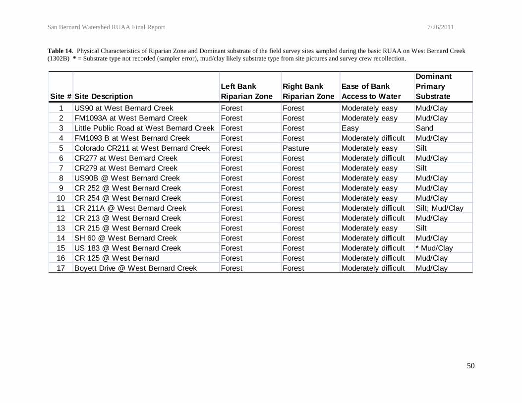
San Bernard Watershed RUAA Final Report 7/26/2011
50
Table 14. Physical Characteristics of Riparian Zone and Dominant substrate of the field survey sites sampled during the basic RUAA on West Bernard Creek
(1302B) * = Substrate type not recorded (sampler error), mud/clay likely substrate type from site pictures and survey crew recollection.
Site # Site Description
Left Bank
Riparian Zone
Right Bank
Riparian Zone
Ease of Bank
Access to Water
Dominant
Primary
Substrate
1 US90 at West Bernard Creek Forest Forest Moderately easy Mud/Clay
2 FM1093A at West Bernard Creek Forest Forest Moderately easy Mud/Clay
3 Little Public Road at West Bernard Creek Forest Forest Easy Sand
4 FM1093 B at West Bernard Creek Forest Forest Moderately difficult Mud/Clay
5 Colorado CR211 at West Bernard Creek Forest Pasture Moderately easy Silt
6 CR277 at West Bernard Creek Forest Forest Moderately difficult Mud/Clay
7 CR279 at West Bernard Creek Forest Forest Moderately easy Silt
8 US90B @ West Bernard Creek Forest Forest Moderately easy Mud/Clay
9 CR 252 @ West Bernard Creek Forest Forest Moderately easy Mud/Clay
10 CR 254 @ West Bernard Creek Forest Forest Moderately easy Mud/Clay
11 CR 211A @ West Bernard Creek Forest Forest Moderately difficult Silt; Mud/Clay
12 CR 213 @ West Bernard Creek Forest Forest Moderately difficult Mud/Clay
13 CR 215 @ West Bernard Creek Forest Forest Moderately easy Silt
14 SH 60 @ West Bernard Creek Forest Forest Moderately difficult Mud/Clay
15 US 183 @ West Bernard Creek Forest Forest Moderately difficult * Mud/Clay
16 CR 125 @ West Bernard Forest Forest Moderately difficult Mud/Clay
17 Boyett Drive @ West Bernard Creek Forest Forest Moderately difficult Mud/Clay

San Bernard Watershed RUAA Final Report 7/26/2011
51
Table 15. Recreational uses observed and interviewed documented by number of observed occurrences for West Bernard Creek (1302B) collected during the
basic RUAA.
Personal Use Witnessed Hearsay
Swimming 3 2 2 7
Tubing 1 1 1 3
Wading - Children 1 1
Wading - Adults 4 2 2 8
Boating 1 1 1 3
Kayaking/Canoeing 2 1 1 4
Fishing 6 4 4 14
Hunting 3 2 3 8
Trapping 1 1 1 3
Standing/Sitting 1 1
Non
Field Survey
Observations
InterviewsTotal
Types of recreation
1°
2°

San Bernard Watershed RUAA Final Report 7/26/2011
52
Field
Survey
Site #
Description
Impediments Evidence Observed Personal Use Witnessed Use Hear-say Use
1 US90 @ West Bernard Creek
Algal film on water
surface, Thick
vegetation, Fence,
Rip rap, Low bridge,
Steep slopes
2 FM1093 A @ West Bernard CreekThick vegetation,
Low bridge
3Little Public Rd @ West Bernard
Creek
Steep slopes, Thick
vegetation, Debris in
channel, Log jam,
Low bridge, Wildlife
4 FM1093 B @ West Bernard CreekSteep slopes, Thick
vegetation, Log jam,
Wildlife
5Colorado CR211 @ West Bernard
Creek
Culvert, Fence, Log
jam, Steep slopes,
Private property
6 CR277 @ West Bernard Creek
Private property,
Fence, Steep
Slope, Thick
vegetation, Log jam,
Dead goat in water
7 CR279 @ West Bernard Creek
Fence, Thick
vegetation, Debris in
channel, Log jam,
Utility pipe
8 US90 B @ West Bernard Creek
Steep slopes, Thick
vegetation, Fence,
Log jam, Private
property, Debris in
channel
9 CR252 @ West Bernard Creek
Thick vegetation,
Steep slopes,
Debris in channel,
Fence, Log jam Foot paths/prints
NANiedziejko Property
Fishing, Hunting,
Wading-Adults
10 CR254 @ West Bernard CreekLog jam, Wildlife,
Steep slopes
Fire pit/ring,
Fishing tackle,
Graffiti, Gun
Shells, Fishing
11Wharton CR211 A @ West Bernard
Creek
Thick vegetation,
Fence, Private
property, Steep
slopes
Foot paths/prints,
Fire pit/ring,
RV/ATV tracks
12 CR213 @ West Bernard Creek
Fence, Debris in
channel, Rip rap,
Steep slopes,
Wildlife, Private
property Fishing tackle
13 CR215 @ West Bernard CreekSteep slopes, Thick
vegetation
14 SH60 @ West Bernard Creek Steep slopes, Thick
vegetation, Debris in
channel, Fence,
Private property Fishing tackle Sitting
Swimming,
Tubing,
Kayaking,
Fishing, Boating,
Trapping,
Hunting, Wading-
Adults
Swimming,
Tubing, Kayaking,
Fishing, Boating,
Trapping, Hunting,
Wading-Adults
Swimming,
Tubing, Kayaking,
Fishing, Boating,
Trapping, Hunting,
Wading-Adults
15 US183 @ West Bernard Creek
Thick vegetation,
Rip rap, Steep
slopes, Fence,
Channel
obstruction,
Wildlife, Dead cow
in water
16 CR225 @ West Bernard Creek
Steep slopes,
Fence, Private
property, No
trespass sign, Dead
Calf in water
Fishing tackle,
Shotgun shell
Swimming,
Kayaking,
Fishing, Hunting,
Wading-Children,
Wading-Adults
Swimming,
Fishing, Hunting,
Wading-Adults
Swimming,
Fishing, Hunting,
Wading-Adults
17 Boyett Drive @ West Bernard CreekSteep slopes, Thick
vegetation, Rip rap
Camping sites,
Fishing tackle,
Shotgun shell,
Foot paths/prints
Table 16. Impediments, evidence of recreational uses, observed recreational uses, and interviewed documented
uses by site on West Bernard Creek (1302B) for the basic RUAA by location.

San Bernard Watershed RUAA Final Report 7/26/2011
53
Summary
Seventeen sites were surveyed on West Bernard Creek as part of this RUAA to evaluate
whether the existing and/or attainable recreational uses of the waterbody might be different than
the current presumed recreational uses. Important data collected in this RUAA included general
stream characteristics, observations and evidence of recreational uses, and surrounding
conditions that promote or impede recreation.
While West Bernard Creek had several impediments to recreational use such as steep
slopes, fences, log jams, and limited public access; the RUAA documented a variety of
recreation activities. The most common recreation activity was fishing. This was observed
during field surveys, cited by interviewees, and evidence of fishing encountered at several survey
sites. Swimming, wading-children and adults, kayaking, hunting, and trapping were also reported
by interviewees. Depths in the creek ranged from 0.13 meters to greater than 1.4 meters
(unwadeable) and the average flow value for all the survey sites was 28.8cfs. RUAA interview
summary analysis indicates that primary contact, secondary contact (1 & 2), and non-contact
recreation activities occur on West Bernard Creek (1302B), while only secondary contact were
documented during the field surveys.

San Bernard Watershed RUAA Final Report 7/26/2011
54
Literature Cited
East, J.W., and J.L. Hogan. 2003. Hydrologic, Water-Quality, and Biological Data for Three
Water Bodies, Texas Gulf Coastal Plain, 2000-2002. U.S. Geological Survey Open-File
Report 03-459.
Handbook of Texas Online. 2010. Texas State Historical Association (TSHA) San Bernard
River. Web Resource:
http://www.tshaonline.org/handbook/online/articles/rns07 Accessed on 8/10/2011.
Houston Association of Sea Kayakers (HASK). 2010. Trip reports and Photos. Web Resource:
http://www.hask.org/content.aspx?page_id=2155&club_id=576607&item_id=139400.
Accessed on 7/14/2011.
Houston-Glaveston Area Council (HGAC) 2011. San Bernard River Watershed Protection Plan
(draft). Web Resource:
http://www.h-gac.com/community/water/watershed_protection/sanbernard/default.aspx
Accessed on 8/10/2011.
Texas Commission on Environmental Quality (TCEQ). 2008. Texas 303(d) list (March 19,
2008). TCEQ, Austin, Texas.
Texas Commission on Environmental Quality (TCEQ). 2009. Recreational Use-Attainability
Analyses (RUAAs) Procedures for a Comprehensive RUAA and a Basic RUAA Survey.
TCEQ, Austin, Texas.
Wunderground. 2011. Weather Station KTXEASTB2 in East Bernard, TX. Web Resource:
http://www.wunderground.com/weatherstation/WXDailyHistory.asp?ID=KTXEASTB2
&day=13&year=2011&month=7&graphspan=year Accessed on 8/10/2011.

San Bernard Watershed RUAA Final Report 7/26/2011
55
RUAA Summary Form
RUAA Summary San Bernard River Above Tidal
This form should be filled out after RUAA data collection is completed. Use the Contact
Information Form, Field Data Sheets from all sites, Historical Information Review, and other
relevant information to answer the following questions on the waterbody.
Name of waterbody: __San Bernard River Above Tidal_________________
Segment No. or Nearest Downstream Segment No.: ____1302_____________
Classified?: __Yes_________________
County: _____Austin, Colorado, Wharton, Fort Bend, and Brazoria_____
1. Observations on Use
a. Do primary contact recreation activities occur on the waterbody?
frequently seldom not observed or reported unknown
b. Do secondary contact recreation 1 activities occur on the waterbody?
frequently seldom not observed or reported unknown
c. Do secondary contact recreation 2 activities occur on the waterbody?
frequently seldom not observed or reported unknown
d. Do noncontact recreation activities occur on the waterbody?
frequently seldom not observed or reported unknown
2. Physical Characteristics of Waterbody
a. What is the average thalweg depth? __>0.9 meters
b. Are there substantial pools deeper than 1 meter? yes no
c. What is the general level of public access?
easy moderate very limited
3. Hydrological Conditions (Based on Palmer Drought Severity Index)
Mild-Extreme Drought Incipient dry spell Near Normal Incipient wet spell Mild-
Extreme Wet

San Bernard Watershed RUAA Final Report 7/26/2011
56
RUAA Summary Gum Tree Branch
This form should be filled out after RUAA data collection is completed. Use the Contact
Information Form, Field Data Sheets from all sites, Historical Information Review, and other
relevant information to answer the following questions on the waterbody.
Name of waterbody: __Gum Tree Branch_________________
Segment No. or Nearest Downstream Segment No.: ____1302A_____________
Classified?: __No_________________
County: _____ Colorado and Wharton_____
1. Observations on Use
a. Do primary contact recreation activities occur on the waterbody?
frequently seldom not observed or reported unknown
b. Do secondary contact recreation 1 activities occur on the waterbody?
frequently seldom not observed or reported unknown
c. Do secondary contact recreation 2 activities occur on the waterbody?
frequently seldom not observed or reported unknown
d. Do noncontact recreation activities occur on the waterbody?
frequently seldom not observed or reported unknown
2. Physical Characteristics of Waterbody
a. What is the average thalweg depth? __0.56 meters
b. Are there substantial pools deeper than 1 meter? yes no NA
c. What is the general level of public access?
easy moderate very limited
3. Hydrological Conditions (Based on Palmer Drought Severity Index)
Mild-Extreme Drought Incipient dry spell Near Normal Incipient wet spell Mild-
Extreme Wet

San Bernard Watershed RUAA Final Report 7/26/2011
57
RUAA Summary West Bernard Creek
This form should be filled out after RUAA data collection is completed. Use the Contact
Information Form, Field Data Sheets from all sites, Historical Information Review, and other
relevant information to answer the following questions on the waterbody.
Name of waterbody: __West Bernard Creek_________________
Segment No. or Nearest Downstream Segment No.: ____1302B_____________
Classified?: __No_________________
County: _____ Colorado and Wharton_____
1. Observations on Use
a. Do primary contact recreation activities occur on the waterbody?
frequently seldom not observed or reported unknown
b. Do secondary contact recreation 1 activities occur on the waterbody?
frequently seldom not observed or reported unknown
c. Do secondary contact recreation 2 activities occur on the waterbody?
frequently seldom not observed or reported unknown
d. Do noncontact recreation activities occur on the waterbody?
frequently seldom not observed or reported unknown
2. Physical Characteristics of Waterbody
a. What is the average thalweg depth? __0.7 meters
b. Are there substantial pools deeper than 1 meter? yes no NA
c. What is the general level of public access?
easy moderate very limited
3. Hydrological Conditions (Based on Palmer Drought Severity Index)
Mild-Extreme Drought Incipient dry spell Near Normal Incipient wet spell Mild-
Extreme Wet