Embed Size (px)
Citation preview
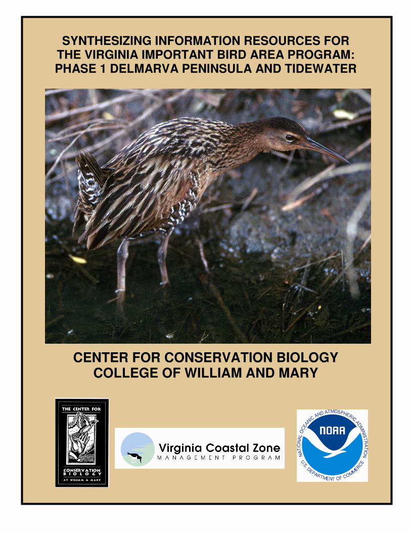
SYNTHESIZING INFORMATION RESOURCES FOR THE VIRGINIA IMPORTANT BIRD AREA PROGRAM: PHASE 1 DELMARVA PENINSULA AND TIDEWATER
CENTER FOR CONSERVATION BIOLOGY COLLEGE OF WILLIAM AND MARY

2
SYNTHESIZING INFORMATION RESOURCES FOR THE VIRGINIA IMPORTANT BIRD AREA PROGRAM: PHASE 1 DELMARVA PENINSULA AND TIDEWATER
Bryan D. Watts Center for Conservation Biology
College of William and Mary Williamsburg, VA 23187-8795
Recommended Citation: Watts, B. D. 2006. Synthesizing information resources for the Virginia Important Bird
Area Program: Phase I Delmarva Peninsula and tidewater. Center for Conservation Biology Technical Report Series, CCBTR-06-05. College of William and Mary, Williamsburg, VA. 70 pp.
Project Funded By:
Virginia Coastal Zone Management Program (Department of Environmental Quality)
The Center for Conservation Biology
College of William and Mary Cover Photo: King Rail by Bryan Watts
The Center for Conservation Biology is an organization dedicated to discovering innovative solutions to environmental problems that are both scientifically sound and practical within todays social context. Our philosophy has been to use a general systems approach to locate critical information needs and to plota deliberate course of action to reach what we believe are essential information endpoints.

3
TABLE OF CONTENTS
BACKGROUND............................................................................................... 4 Context ................................................................................................. 4 Objectives.............................................................................................. 4 VIRGINIA BARRIER ISLAND/LAGOON IBA.................................................. 5 CHESAPEAKE BAY ISLANDS IBA................................................................ 20 DELMARVA BAYSIDE MARSHES IBA………………………………………… 31 LOWER DELMARVA PENINSULA IBA.......................................................... 46 BACK BAY IBA…………………………………………………………………….. 59 ACKNOWLEDGMENTS…………………………………………………………… 70

4
BACKGROUND Context The Important Bird Areas (IBA) program is a science-based initiative to identify, conserve, and monitor sites that provide essential habitat for bird populations. Developed in Europe, the program has expanded to become an international network of conservation sites. Under this initiative, sites that are critical for the long-term survival of bird populations have been identified across the globe using internationally agreed upon criteria. The quality and effectiveness of this conservation network depends directly on the information resources and expertise used in its development. The National Audubon Society with funding from the Virginia Department of Game & Inland Fisheries and other groups has recently established an IBA program in Virginia. The purpose of this program is to identify, establish, and work toward the conservation of locations of importance to birds in Virginia. Objectives The primary objective of this project is to utilize existing information resources to delineate important bird areas in coastal Virginia. Information resources will be identified, compiled, and synthesized in order to place geographic locations within the appropriate local, regional, and national context in terms of their importance to bird species of conservation concern. Specific objectives include: 1) to delineate boundaries of IBAs based on available information resources. 2) to nominate areas determined to meet biological criteria to the IBA technical committee for consideration/approval as IBAs.

5
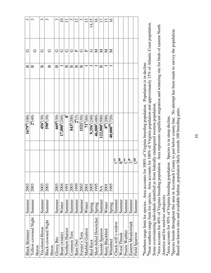
Virginia Barrier Island/Lagoon Important Bird Area Fact Sheet Location: Accomack and Northampton Counties Total Size : 105,249 ha (259,965 acres) Elevation: 0-15 m (0-49 feet) Site Description: The Virginia Barrier Island/Lagoon system includes the seaward margin of the lower Delmarva Peninsula from the mouth of the Chesapeake Bay to the MD-VA border. This location is the most important bird are in Virginia and one of the most important bird areas along the Atlantic Coast of North America. The area has been designated as a UNESCO Biosphere Reserve, a Western Hemisphere Shorebird Reserve Site with international status and is the site of a National Science Foundation Long-term Ecological Research site and the focus of a multi-organizational partnership dedicated to bird conservation. The area includes the most pristine chain of barrier islands along the Atlantic Coast, maritime forests, extensive salt marshes, inter-tidal mudflats, and open water. Although much of the system is currently owned by government agencies and conservation organizations, numerous conservation challenges remain. Protection: A significant portion of the Virginia Barrier Island/Lagoon Important Bird Area is owned and protected to meet conservation objectives. Most of the habitat contained within the 14 barrier islands is owned by The Nature Conservancy, the U.S. Fish and Wildlife Service, NASA, and the Virginia Department of Conservation and Recreation, Division of Natural Heritage with relatively few private holdings. Much of the extensive tidal marsh within the site is owned by the Virginia Marine Resources Commission, The Nature Conservancy, the U.S. Fish and Wildlife Service, NASA, and the Virginia Department of Game and Inland Fisheries.
Birds: The Virginia Barrier Island/Lagoon System supports the highest diversity and density of birds of conservation concern within Virginia. Several beach-nesting species such as the Piping Plover, Wilson’s Plover, American Oystercatcher, Gull-billed Tern, Least Tern, and Black Skimmer that are of high regional or national concern nest exclusively or nearly so within this system. The area supports the most significant breeding populations in the state of waders such as the Little Blue Heron, Tricolored Heron, Snowy Egret, Glossy Ibis, and Black-crowned Night Heron. Marsh-nesting species such as the Forster’s Tern, Seaside Sparrow, and Saltmarsh Sharp-tailed Sparrow, also have their center of abundance here. During migration the area is of international significance as a stopover area for Whimbrel, Short-billed Dowitcher, and Red Knot. In addition, the area supports significant wintering populations of Nelson’s Sharp-tailed Sparrow, Atlantic Brant, and Dunlin. Conservation and Threats: Four primary threats are currently of concern including 1) predator impacts on nesting species, 2) loss of habitat to invasion by Phragmites, 3)
Royal Tern
6
human disturbance during the nesting season, and 4) loss of habitat to sea level rise. Colonization of most islands by raccoon and red fox are believed to be at least partially responsible for documented population declines and low reproductive rates for some species. Current research and management programs are addressing this threat. Predation by Herring and Great Black-backed Gulls are also of concern, as is, predation by the introduced population of Peregrine Falcons. Phragmites has spread rapidly throughout this system and is displacing several critical habitats. Strategic research and management is beginning to address this threat though the eventual outcome is uncertain. The increase in human visitation to portions of this system during the breeding season is an ongoing concern. Management activities and ongoing educational programs are designed to reduce this impact. Like in many coastal systems, the loss of habitat to sea-level rise is a long-term concern.
7
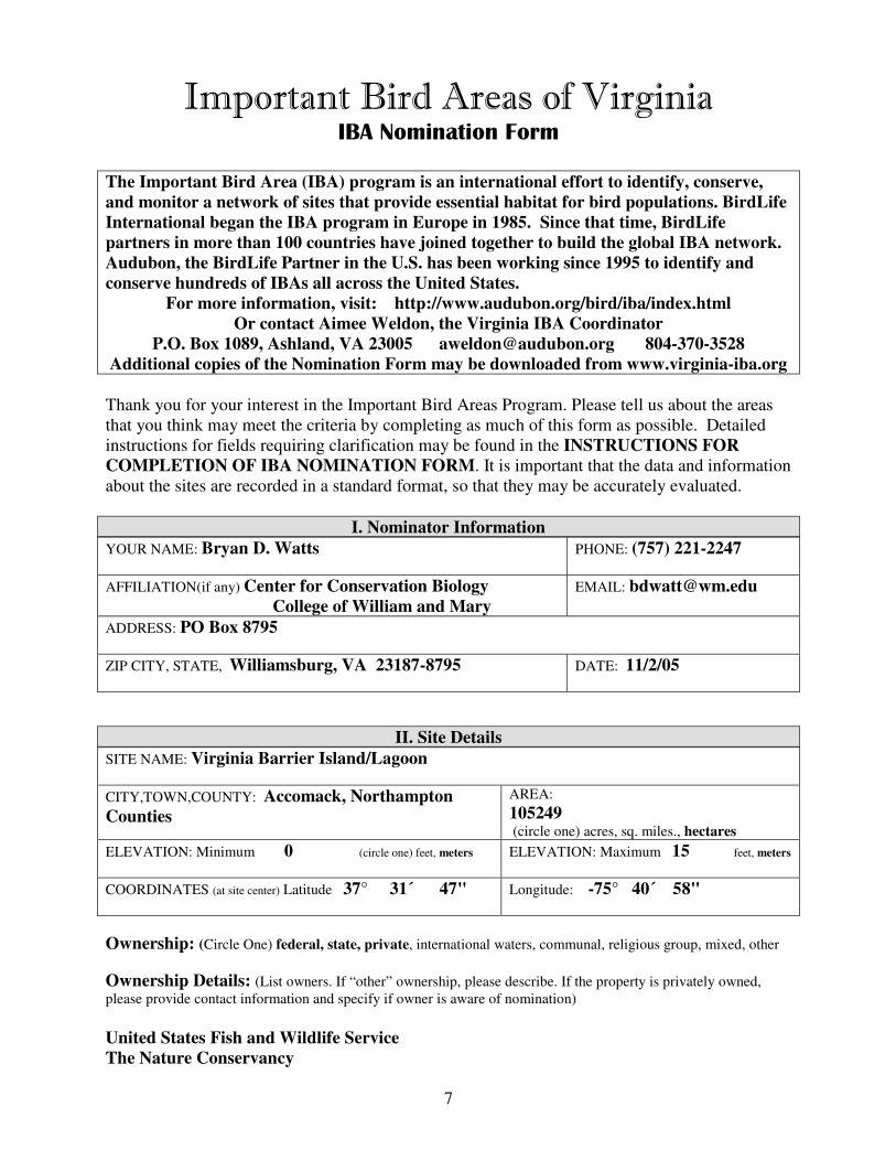
Important Bird Areas of Virginia IBA Nomination Form
The Important Bird Area (IBA) program is an international effort to identify, conserve,
and monitor a network of sites that provide essential habitat for bird populations. BirdLife
International began the IBA program in Europe in 1985. Since that time, BirdLife
partners in more than 100 countries have joined together to build the global IBA network.
Audubon, the BirdLife Partner in the U.S. has been working since 1995 to identify and
conserve hundreds of IBAs all across the United States.
For more information, visit: http://www.audubon.org/bird/iba/index.html
Or contact Aimee Weldon, the Virginia IBA Coordinator
P.O. Box 1089, Ashland, VA 23005 [email protected] 804-370-3528
Additional copies of the Nomination Form may be downloaded from www.virginia-iba.org
Thank you for your interest in the Important Bird Areas Program. Please tell us about the areas
that you think may meet the criteria by completing as much of this form as possible. Detailed
instructions for fields requiring clarification may be found in the INSTRUCTIONS FOR
COMPLETION OF IBA NOMINATION FORM. It is important that the data and information
about the sites are recorded in a standard format, so that they may be accurately evaluated.
I. Nominator Information
YOUR NAME: Bryan D. Watts PHONE: (757) 221-2247
AFFILIATION(if any) Center for Conservation Biology
College of William and Mary
EMAIL: [email protected]
ADDRESS: PO Box 8795
ZIP CITY, STATE, Williamsburg, VA 23187-8795 DATE: 11/2/05
II. Site Details
SITE NAME: Virginia Barrier Island/Lagoon
CITY,TOWN,COUNTY: Accomack, Northampton
Counties
AREA:
105249 (circle one) acres, sq. miles., hectares
ELEVATION: Minimum 0 (circle one) feet, meters ELEVATION: Maximum 15 feet, meters
COORDINATES (at site center) Latitude 37° 31´ 47" Longitude: -75° 40´ 58"
Ownership: (Circle One) federal, state, private, international waters, communal, religious group, mixed, other
Ownership Details: (List owners. If “other” ownership, please describe. If the property is privately owned,
please provide contact information and specify if owner is aware of nomination)
United States Fish and Wildlife Service
The Nature Conservancy

8
Virginia Department of Game and Inland Fisheries
Virginia Department of Conservation and Recreation
Virginia Marine Resources Commission
National Aeronautics and Space Administration
Northampton County
Many private holdings
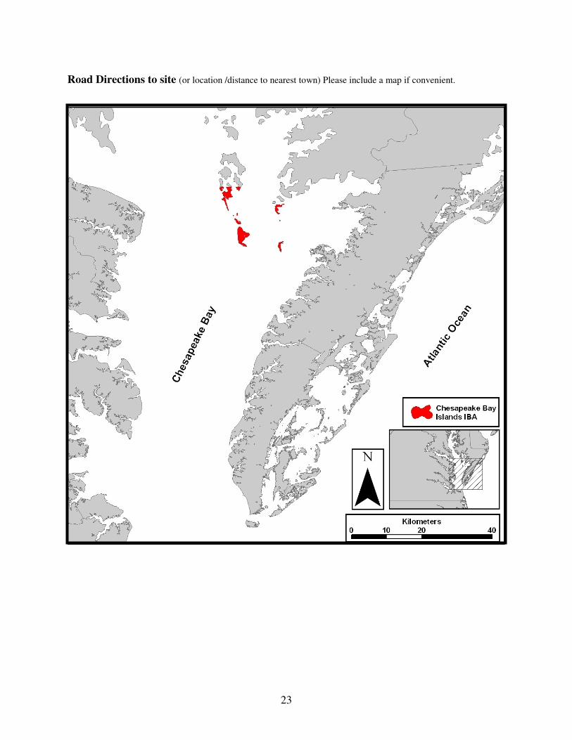
Road Directions to site (or location /distance to nearest town) Please include a map if convenient.

9
Sit
e N
am
e:
Vir
gin
ia B
arri
er I
slan
d/L
ago
on
III
A. S
pec
ies
Lis
t an
d P
op
ula
tion
Data
L
ist
the
spec
ies
of
signif
ican
ce. P
rovid
e al
l oth
er i
nfo
rmat
ion a
t your
dis
po
sal
(note
: T
yp
es o
f B
irds
Counte
d i
s re
quir
ed).
Eac
h r
ecord
should
repre
sent
a co
unt
at t
he
site
in a
giv
en y
ear.
P
lease
use
th
e fo
llow
ing c
od
es w
hen
com
ple
tin
g t
his
ch
art
.
1.
Rel
ati
ve
Ab
un
da
nce
: A
bund
ant
= A
, C
om
mo
n =
C,
Fre
quen
t =
F,
Unco
mm
on =
U,
Rar
e =
R,
No
t av
aila
ble
= N
A
2.
Co
un
t:
Fo
r al
l sp
ecie
s, e
nte
r ei
ther
Den
sity
(#
per
unit
of
area
), p
leas
e sp
ecif
y h
a, a
cres
, sq
. m
i.
or
Ma
x #
.
Ma
x #
is
the
hig
hest
# o
bse
rved
on o
ne
vis
it i
n a
giv
en
sea
son.
To
tal
seas
on c
ou
nts
may b
e en
tere
d f
or
mig
rati
ng r
apto
rs o
nly
.
3.
Ty
pes
of
Bir
ds
Co
un
ted
: I
nd
ivid
uals
= I
, B
reed
ing P
airs
= B
, A
dult
s o
nly
= A
, M
ales
only
= M
, F
em
ales
only
= F
, N
ests
= N
4.
Rel
iab
ilit
y/D
ata
qu
ali
ty:
Go
od
= G
, M
ediu
m =
M, P
oor
= P
, U
nkno
wn
= U
n
5.
So
urc
e:
Ente
r th
e nu
mb
er o
f th
e so
urc
e in
this
bo
x,
and
lis
t co
rres
po
nd
ing d
etai
ls o
f th
e so
urc
es i
n S
ourc
e D
etai
ls (
IIIB
) se
ctio
n.
So
urc
es m
ay i
ncl
ud
e p
ub
lish
ed
rep
ort
s, s
urv
eys,
per
sonal
ob
serv
atio
ns
or
fiel
d n
ote
s.
( )
valu
es r
epre
sen
t p
op
ula
tion
th
resh
old
s p
er t
he
Vir
gin
ia I
BA
in
stru
ctio
ns.
2C
ou
nts
All
Gro
up
s M
igra
tin
g R
apto
rs O
nly
S
pec
ies
Nam
e
Sea
son
Mo
nth
/Day
of
Ob
serv
atio
n
Yea
r o
f
Ob
serv
atio
n
1R
elat
ive
Ab
un
dan
ce
D
ensi
ty
o
r
M
ax
# /
___
are
a
#
/ v
isit
T
ota
l S
easo
n C
ou
nt
3T
yp
es
of
Bir
ds
Co
unte
d
4R
elia
bil
ity
/Dat
a Q
ual
ity
5S
ou
rce
Wil
son’s
Plo
ver
Ju
ne
2005
24
a(a
ll)
B
G
1
Pip
ing P
lover
Ju
ne
2005
151
b(a
ll)
B
G
1
Per
egri
ne
Fal
con
Spri
ng
2005
8c
B
G
2
Gull
-bil
led T
ern
Sum
mer
2003
304
d(1
0)
B
G
3
Sal
tmar
sh S
har
p-t
aile
d
Spar
row
Sum
mer
1999
1e (5
)
M
P
4
Nel
son’s
Shar
p-t
aile
d
Spar
row
Win
ter
110
f (100)
I
P
5
Lit
tle
Blu
e H
eron
Sum
mer
2003
249
g(1
0)
B
G
3
Am
eric
an B
lack
Duck
S
um
mer
2005
10,2
0h(5
)
B
M
6, 7
Bal
d E
agle
S
um
mer
2005
3i (3
0)
B
G
8
Am
eric
an
Oyst
erca
tcher
Sum
mer
2003
525
j (15)
B
G
9
Lea
st T
ern
Sum
mer
2003
703
k(5
0)
B
G
3
Ro
yal
Ter
n
Sum
mer
2003
2058
l (300)
B
G
3
10
Bla
ck S
kim
mer
S
um
mer
2003
1679
m(1
00)
B
G
3
Yel
low
-cro
wned
Nig
ht
Her
on
Sum
mer
2003
2n(4
0)
B
G
3
Tri
colo
red H
eron
Sum
mer
2003
456
o(3
0)
B
G
3
Bla
ck-c
row
ned
Nig
ht
Her
on
Sum
mer
2003
590
p(3
0)
B
G
3
Glo
ssy I
bis
S
um
mer
2003
669
q(3
0)
B
G
3
Bra
nt
(win
ter)
W
inte
r 2004
17,0
00
r (240)
I
G
10
Nort
her
n H
arri
er
Sum
mer
1991
8s
B
G
11
Com
mon T
ern
Sum
mer
2003
843
t (200)
B
G
3
Bar
n O
wl
Sum
mer
1999
2u(5
)
B
P
12
Fors
ter’
s T
ern
Sum
mer
2003
1521
v(5
0)
B
G
3
Mar
ble
d G
odw
it
Win
ter
2001
71
w(6
0)
I
P
13
Red
Knot
Spri
ng
2005
9,3
56
x(2
40)
I
G
14,1
5
Short
-bil
led D
ow
itch
er
Spri
ng
1995
46,0
00
y(4
80)
I
M
16
Sea
side
Spar
row
S
um
mer
N
A
122,0
00
z (500)
B
M
17
Rust
y B
lack
bir
d
Win
ter
2001
8a
a(2
00)
I
M
13
Whim
bre
l S
pri
ng
1995
40,0
00
bb(7
20)
I
M
16
Chuck
-wil
l’s-
wid
ow
S
um
mer
Ccc
Wood T
hru
sh
Sum
mer
Rd
d
Pra
irie
War
ble
r S
um
mer
Cee
Eas
tern
Mea
dow
lark
S
um
mer
Uff
Fie
ld S
par
row
S
um
mer
Ug
g
aN
ort
her
n r
ange
lim
it f
or
spec
ies.
A
rea
acco
unts
for
100%
of
Vir
gin
ia b
reed
ing p
opula
tion. P
opula
tion i
s in
dec
line.
bN
ear
south
ern r
ange
lim
it f
or
spec
ies.
A
rea
acco
unts
for
100%
of
Vir
gin
ia p
opula
tion a
nd a
ppro
xim
atel
y 1
5%
of
Atl
anti
c C
oas
t popula
tion.
Som
e over
win
teri
ng i
ndiv
idual
s id
enti
fied
as
fro
m f
eder
ally
endan
ger
ed w
este
rn p
opula
tion.
c Are
a ac
counts
for
40
% o
f V
irgin
ia b
reed
ing p
op
ula
tion. A
rea
repre
sents
sig
nif
ican
t m
igra
tion a
nd
win
teri
ng s
ite
for
bir
ds
of
east
ern N
ort
h
Am
eric
a an
d f
or
tundri
us
subsp
ecie
s.
dA
rea
acco
unts
for
95%
of
Vir
gin
ia b
reed
ing p
op
ula
tion. S
pec
ies
is i
n s
teep
dec
line.
e S
pec
ies
bre
eds
thro
ugho
ut
this
are
a in
Acc
om
ack C
ounty
to j
ust
bel
ow
cou
nty
lin
e. N
o a
ttem
pt
has
bee
n m
ade
to s
urv
ey t
he
popula
tion.
Bas
ed o
n k
no
wn s
ites
an
d a
vai
lable
hab
itat
, popula
tion l
ikel
y e
xce
eds
100 b
reed
ing p
airs
.

11
f No s
yst
emat
ic s
urv
ey o
f sp
ecie
s co
mple
x. C
hri
stm
as B
ird C
ounts
cover
sm
all
port
ion o
f th
is s
yst
em. T
his
are
a is
lik
ely t
o s
upport
a w
inte
r
popula
tion i
n t
he
thousa
nds.
gA
rea
acco
unts
for
80%
of
Vir
gin
ia b
reed
ing p
op
ula
tion.
hP
opula
tion h
as e
xper
ience
d d
ram
atic
dec
line
du
e to
mam
mal
ian p
redat
ion.
Bydro
wsk
i an
d C
ost
anzo d
ocu
men
ted 1
0 n
ests
in
2003. A
rquil
la
docu
men
ted 2
0 i
n 2
005. N
eith
er e
ffort
cov
ered
en
tire
syst
em.
i Are
a is
not
signif
ican
t fo
r bre
edin
g p
opula
tion, re
pre
senti
ng l
ess
than
1%
of
stat
e popula
tion. R
ecen
t in
dic
atio
n o
f th
e fo
rmat
ion o
f a
win
ter
conce
ntr
atio
n a
rea
in n
ort
her
n p
ort
ion.
j Are
a su
pport
s 90%
of
Vir
gin
ia b
reed
ing p
opula
tio
n. A
rea
suppo
rts
larg
est
and m
ost
pro
duct
ive
bre
edin
g p
opula
tion t
hro
ugho
ut
the
spec
ies
ran
ge.
A
rea
suppo
rts
the
seco
nd h
ighes
t w
inte
r po
pula
tion k
now
n t
hro
ugho
ut
range.
k A
rea
support
s 83%
of
Vir
gin
ia b
reed
ing p
opula
tion. P
opula
tion h
as e
xper
ience
d l
ong-t
erm
dec
line.
l A
rea
support
s 72%
of
Vir
gin
ia b
reed
ing p
opula
tio
n. P
opula
tion h
as e
xper
ience
d l
oca
l dec
line
but
moves
over
lar
ge
geo
gra
ph
ic a
reas
. m
Are
a su
pport
s 92%
of
Vir
gin
ia b
reed
ing p
opula
tion. P
opula
tion h
as e
xper
ience
d s
ignif
ican
t dec
line.
nS
urv
eys
thro
ughout
the
1990s
pla
ced t
he
popula
tion w
ithin
the
area
aro
un
d 5
0 b
reed
ing p
airs
. S
pec
ies
is d
iffi
cult
to s
urv
ey.
Popula
tion
wit
hin
the
area
is
more
lik
ely 5
0-1
00 p
airs
. oA
rea
support
s 90%
of
Vir
gin
ia b
reed
ing p
opula
tion.
pA
rea
suppo
rts
92%
of
Vir
gin
ia b
reed
ing p
opula
tion.
qA
rea
suppo
rts
82%
of
Vir
gin
ia b
reed
ing p
opula
tion.
r Are
a re
pre
sents
one
of
the
most
sig
nif
ican
t w
inte
ring a
reas
for
this
spec
ies
along A
tlan
tic
Coas
t.
s Are
a is v
ery n
ear
the
sou
ther
n r
ange
lim
it f
or
the
spec
ies.
A
rea
support
s ap
pro
xim
atel
y 3
0%
of
kno
wn V
irgin
ia b
reed
ing p
opula
tion.
t Are
a su
pport
s 45%
of
Vir
gin
ia b
reed
ing p
opula
tio
n.
uN
o s
yst
emat
ic d
ata
avai
lable
for
this
spec
ies
wit
hin
the
area
. C
oll
ecti
ve
ob
serv
atio
ns
over
the
yea
rs s
ugges
t a
dec
line
in t
he
popula
tion b
ut
that
the
popula
tion s
till
lik
ely e
xce
eds
20 p
airs
. vA
rea
support
s 61%
of
Vir
gin
ia b
reed
ing p
opula
tion.
wN
o s
yst
emat
ic s
urv
ey f
or
this
spec
ies.
N
um
ber
der
ived
fro
m C
hin
cote
agu
e, W
achap
reag
ue,
and C
ape
Char
les
Chri
stm
as B
ird C
ounts
.
Com
bin
ed t
hes
e co
unts
typ
ical
ly a
ccount
for
50-1
00 i
ndiv
idual
s. H
ow
ever
, th
ese
counts
cover
a r
elat
ivel
y s
mal
l port
ion o
f th
e over
all
syst
em
sugges
tin
g t
hat
thes
e nu
mber
s ar
e su
bst
anti
al u
nder
esti
mat
es.
xA
eria
l su
rvey e
stim
ate
consi
sten
t w
ith p
eak c
ounts
fro
m a
eria
l su
rveys
in t
he
1990s.
T
his
est
imat
e now
appea
rs t
o a
ccount
for
30%
of
popula
tion m
ovin
g a
lon
g t
he
Atl
anti
c C
oas
t.
yL
agoon s
yst
em i
s an
im
port
ant
stag
ing a
rea
for
this
spec
ies.
N
um
ber
is
a pro
ject
ion b
ased
on 1
0 a
eria
l tr
anse
cts
flow
n w
eek
ly i
n t
he
spri
ngs
of
1994-1
996.
z Are
a su
pport
s si
gnif
ican
t bre
edin
g p
opula
tion. N
um
ber
is
a pro
ject
ion b
ased
on d
ensi
ty e
stim
ate
and a
vai
lable
hab
itat
.

12
aa N
o s
yst
emat
ic s
urv
ey f
or
this
spec
ies.
N
um
ber
der
ived
fro
m C
hin
cote
ague,
Wac
hap
reag
ue,
and C
ape
Char
les
Chri
stm
as B
ird C
ounts
. A
s
rece
ntl
y a
s 1998
-99 t
hes
e co
unts
had
336. T
hes
e co
unts
cover
a r
elat
ivel
y s
mal
l port
ion o
f th
e over
all
syst
em s
ugges
ting t
hat
thes
e num
ber
s ar
e
subst
anti
al u
nder
esti
mat
es.
bb L
agoon s
yst
em i
s a
hem
ispher
ical
ly i
mport
ant
stag
ing a
rea
for
this
spec
ies.
N
um
ber
is
a pro
ject
ion b
ased
on 1
0 a
eria
l tr
anse
cts
flow
n
wee
kly
in t
he
spri
ngs
of
1994-1
996. I
t is
bel
ieved
that
this
sit
e su
pport
s vir
tual
ly a
ll i
ndiv
idual
s m
ovin
g a
lon
g t
he
Atl
anti
c C
oas
t in
spri
ng.
Conti
nen
tal
esti
mat
e fo
r th
is s
pec
ies
was
der
ived
fro
m t
his
set
of
aeri
al s
urv
eys.
cc
No s
yst
emat
ic s
urv
ey f
or
this
spec
ies.
T
he
spec
ies
is c
om
mon w
ithin
the
pin
e hum
mock
s an
d s
tan
ds
wher
e hig
h g
round i
s av
aila
ble
.
Bre
edin
g p
opula
tion l
ikel
y w
ell
over
100 p
airs
in t
his
are
a.
ddN
o s
yst
emat
ic s
urv
ey f
or
this
spec
ies.
A
ppea
rs t
o b
e a
rare
bre
eder
wit
h v
ery l
ittl
e hab
itat
avai
lab
le. A
rea
not
signif
ican
t fo
r th
is s
pec
ies
eeN
o s
yst
emat
ic s
urv
ey f
or
this
spec
ies.
C
om
mon b
reed
er w
ithin
most
isl
ands
and h
igh a
reas
wit
h s
uit
able
veg
etat
ion. P
opula
tion l
ikel
y w
ell
over
100 p
airs
.
ffN
o s
yst
emat
ic s
urv
ey f
or
this
spec
ies.
S
pec
ies
do
es b
reed
thro
ughout
the
area
but
hab
itat
is
lim
ited
. A
rea
not
signif
ican
t fo
r th
is s
pec
ies.
g
gN
o s
yst
emat
ic s
urv
ey f
or
this
spec
ies.
S
pec
ies
does
bre
ed t
hro
ughout
the
area
but
hab
itat
is
lim
ited
. A
rea
not
signif
ican
t fo
r th
is s
pec
ies.

13
Site Name: Virginia Barrier Island/Lagoon
III B. Source Details
Detail the sources of data noted in the “Species List and Population Data” (III A) Section.
If additional space is needed, you may attach copies of this form to the nomination.
1. Boettcher, R. 2005. Virginia survey of Piping and Wilson’s Plovers: 2005 breeding season.
Virginia Department of Game and Inland Fisheries, Unpublished report.
2. Watts, B. D., Padgett, S. M., M. A. Byrd, and E. C. Long. 2005. Virginia Peregrine Falcon
monitoring and management program: Year 2005 report. Center for Conservation Biology
Technical Report Series, CCBTR-05-09. College of William and Mary, Williamsburg, VA. 12
pp.
3. Watts, B. D. 2004. Status and distribution of colonial waterbirds in coastal Virginia: 2003
breeding season. CCBTR-04-06. Center for Conservation Biology, College of William and
Mary, Williamsburg, VA 25 pp
4. Brinkley, E. S. 2000. The 1999 Northampton County foray (Part 2). The Raven 71:48-70.
5. Kain, T. 2001. Virginia Christmas Bird Counts 2000-2001 season. The Raven 72:17-51.
6. Bydrowski, T. and G. Costanzo. 2003. Progress report: Survey of breeding Black Ducks on
the Virginia Barrier Islands, Spring 2003. Unpublished Report, Virginia Department of Game
and Inland Fisheries. Richmond, VA.
7. Arquilla, B. 2005. The impact of predator reduction on the productivity of American black
ducks and other ground nesting avifauna on the Virginia Coast Reserve. Unpublished Data.
8. Watts, B. D. and M. A. Byrd 2005. Virginia bald eagle nest and productivity survey: Year
2005 report. Center for Conservation Biology Technical Report Series, CCBTR-05-05. College
of William and Mary, Williamsburg, VA. 27 pp.
9. Wilke, A. L., B. D. Watts, B. R. Truitt, and R. Boettcher. 2005. Breeding season status of the
American Oystercatcher in Virginia, USA. Waterbirds 28:308-315.
10. USFWS 2004 Mid-Winter Waterfowl Survey Report.
11. Watts, B. D. and S. J. Rottenborn. 2001. Breeding status of Northern Harriers in coastal
Virginia. The Raven 72:153-157.
12. Brinkley, E. S. 2000. The 1999 Northampton County Foray (Part 1). The Raven 71:3-21.
13. Kain, T. 2002. Virginia Christmas Bird Counts 2001-2002 season. The Raven 73:17-54.
14. Watts, B. D. and B. R. Truitt. 2005. Aerial survey of Virginia Barrier Islands, Unpublished
data

14
15. Watts, B. D. and B. R. Truitt. 2001. Abundance of shorebirds along the Virginia Barrier
Islands during spring migration. The Raven. 71:1-12.
16. Watts, B. D. and B. R. Truitt. Abundance of migrant shorebirds within the barrier
island/lagoon system of the lower Delmarva Peninsula. Unpublished Manuscript.
17. Wilson, M. D. and B. D. Watts. Population projection of Seaside Sparrows within the lower
Delmarva lagoon system. Unpublished analysis.
Site Name: Virginia Barrier Island/Lagoon
IV. IBA Criteria
Proposed State Level Criteria – Mark all that apply
See Instruction IV for Explanations of Criteria.
Code State Definition Mark all
criteria that
apply
D 1.
D 3.
D 4.
Endangered, threatened, or vulnerable species: The site sustains a
breeding or non-breeding population of one or more bird species, sub-
species, or isolated populations that is/are endangered, threatened or
vulnerable to extirpation.
The site contains a significant suite of species associated with a habitat
type that is representative, rare, or threatened in Virginia.
The site contains a significant concentration of one or more species
during the breeding season, winter, or during migration.
Yes
Yes
Yes
V. Habitat Details
See Instruction V for List of Habitats at both levels below.
Major vegetation community types Predominant plant species Cover %
Open beach
Dune Grassland
Wax myrtle
1.
Barrier/Bay Island
Loblolly pine
Spartinal alterniflora 2.
Saltmarsh
Spartina patens
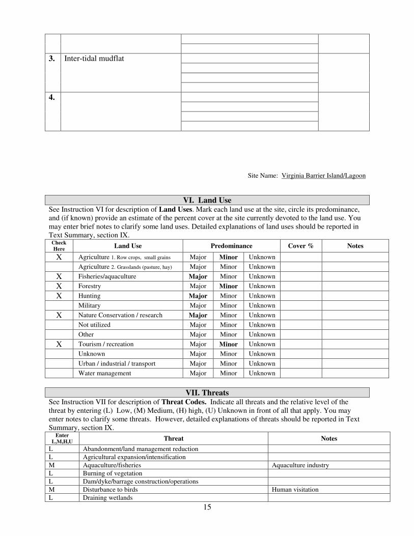
15
3.
Inter-tidal mudflat
4.
Site Name: Virginia Barrier Island/Lagoon
VI. Land Use See Instruction VI for description of Land Uses. Mark each land use at the site, circle its predominance,
and (if known) provide an estimate of the percent cover at the site currently devoted to the land use. You
may enter brief notes to clarify some land uses. Detailed explanations of land uses should be reported in
Text Summary, section IX. Check
Here Land Use Predominance Cover % Notes
X Agriculture 1. Row crops, small grains Major Minor Unknown
Agriculture 2. Grasslands (pasture, hay) Major Minor Unknown
X Fisheries/aquaculture Major Minor Unknown
X Forestry Major Minor Unknown
X Hunting Major Minor Unknown
Military Major Minor Unknown
X Nature Conservation / research Major Minor Unknown
Not utilized Major Minor Unknown
Other Major Minor Unknown
X Tourism / recreation Major Minor Unknown
Unknown Major Minor Unknown
Urban / industrial / transport Major Minor Unknown
Water management Major Minor Unknown
VII. Threats See Instruction VII for description of Threat Codes. Indicate all threats and the relative level of the
threat by entering (L) Low, (M) Medium, (H) high, (U) Unknown in front of all that apply. You may
enter notes to clarify some threats. However, detailed explanations of threats should be reported in Text
Summary, section IX. Enter
L,M,H,U Threat Notes
L Abandonment/land management reduction
L Agricultural expansion/intensification
M Aquaculture/fisheries Aquaculture industry
L Burning of vegetation
L Dam/dyke/barrage construction/operations
M Disturbance to birds Human visitation
L Draining wetlands

16
L Dredging/canal building (irrigation)
L Filling wetlands
L Forest grazing (by native or domestic herbivores)
L Groundwater extraction
L Industrialization/urbanization
L Infrastructure (roads, power lines, cell towers, etc.)
L Intensified forest management (please elaborate)
L Isolation/fragmentation
L Mineral/oil/peat extraction
H Natural events Loss of marsh to sea level rise
H Nonnative (exotic) animal/plant introduction Loss of habitat to Phragmites
H Other Loss of habitat to mammalian predators
L Pesticide application (non-agricultural)
L Plantation forestry (Afforestation) on previously open land
L Recreation/tourism
L Unsustainable exploitation of birds
Site Name: Virginia Barrier Island/Lagoon
VIII. Protected Areas
Complete only if this site contains or abuts protected area(s)! Enter name and descriptions of protected areas contained within or adjacent to this site.
See Instruction VIII
1. Name of protected area:
Virginia Coast Reserve – The Nature Conservancy Designation: Area: circle one: hectares, acres, sq.
miles
Relationship: Circle one Protected area contains IBA, Is adjacent to IBA,
Is contained by IBA, Overlaps with IBA,
Unknown
Overlap: circle one: hectares, acres, sq.
miles
8658.3
2. Name of protected area:
Chincoteague National Wildlife Refuge – U.S. Fish and Wildlife Service Designation: Area: circle one: hectares, acres, sq.
miles
Relationship: Circle one Protected area contains IBA, Is adjacent to IBA,
Is contained by IBA, Overlaps with IBA,
Unknown
Overlap: circle one: hectares, acres, sq.
miles
5121.2
3. Name of protected area:
Wallops Island - NASA Designation: Area: circle one: hectares, acres, sq.
miles
Relationship: Circle one Protected area contains IBA, Is adjacent to IBA,
Is contained by IBA, Overlaps with IBA,
Overlap: circle one: hectares, acres, sq.
miles

17
Unknown 1810.4
4. Name of protected area:
Wreck Island Natural Area Preserve – Virginia Department of Conservation and Recreation Designation: Area: circle one: hectares, acres, sq.
miles
345.9
Relationship: Circle one Protected area contains IBA, Is adjacent to IBA,
Is contained by IBA, Overlaps with IBA,
Unknown
Overlap: circle one: hectares, acres, sq.
miles
345.9
5. Name of protected area:
Mockhorn Island, Wildlife Management Area – Virginia Department of Game and Inland
Fisheries Designation: Area: circle one: hectares, acres, sq.
miles
3072.6
Relationship: Circle one Protected area contains IBA, Is adjacent to IBA,
Is contained by IBA, Overlaps with IBA,
Unknown
Overlap: circle one: hectares, acres, sq.
miles
3072.6
6. Name of protected area:
Fisherman Island, National Wildlife Refuge – U.S. Fish and Wildlife Service Designation: Area: circle one: hectares, acres, sq.
miles
659.1
Relationship: Circle one Protected area contains IBA, Is adjacent to IBA,
Is contained by IBA, Overlaps with IBA,
Unknown
Overlap: circle one: hectares, acres, sq.
miles
659.1
7. Name of protected area:
Eastern Shore of Virginia, National Wildlife Refuge – U.S. Fish and Wildlife Service Designation: Area: circle one: hectares, acres, sq.
miles
Relationship: Circle one Protected area contains IBA, Is adjacent to IBA,
Is contained by IBA, Overlaps with IBA,
Unknown
Overlap: circle one: hectares, acres, sq.
miles
344.0
8. Name of protected area:
Virginia Common Lands – Virginia Marine Resources Commission Designation: Area: circle one: hectares, acres, sq.
miles
10402.5
Relationship: Circle one Protected area contains IBA, Is adjacent to IBA,
Is contained by IBA, Overlaps with IBA,
Unknown
Overlap: circle one: hectares, acres, sq.
miles
10402.5
8. Name of protected area:

18
Indiantown Recreation Park – Northampton County Designation: Area: circle one: hectares, acres, sq.
miles
Relationship: Circle one Protected area contains IBA, Is adjacent to IBA,
Is contained by IBA, Overlaps with IBA,
Unknown
Overlap: circle one: hectares, acres, sq.
miles
4.9
IX. Text Summary
Use the following space for additional descriptions of site details.
General Site Description: The Virginia Barrier Island/Lagoon system includes the seaward
margin of the lower Delmarva Peninsula from the mouth of the Chesapeake Bay to the MD-VA
border. This location is the most important bird are in Virginia and one of the most important
bird areas along the Atlantic Coast of North America. The area has been designated as a
UNESCO Biosphere Reserve, a Western Hemisphere Shorebird Reserve Site with international
status and is the site of a National Science Foundation Long-term Ecological Research site and
the focus of a multi-organizational partnership dedicated to bird conservation. The area includes
the most pristine chain of barrier islands along the Atlantic Coast, extensive salt marshes, inter-
tidal mudflats, and open water. Although much of the system is currently owned by government
agencies and conservation organizations, numerous conservation challenges remain.
General Ornithological Information: The Virginia barrier islands have been the focus of
ornithological interest since the 1850s and conservation efforts since the early 1900s. A very
large number of surveys and research projects have been conducted throughout the 1900s. Work
within this system has intensified since the mid-1970s. Of particular note is the 30-year,
Williams et al. data set of colonial waterbird and beach-nesting birds along the barrier islands
from Assawoman Island south to Fisherman Island. Tow benchmark colonial waterbird surveys
(1993 and 2003) have placed the area into context with the rest of coastal Virginia and the
broader physiographic region. Also of note is the 20-year, Virginia Department of Game and
Inland Fisheries data set of Piping and Wilson’s Plovers along the entire island chain. Since
2000, a systematic survey has also been conducted for American Oystercatchers.
Comprehensive monitoring of reproductive rates is available for the past several years for
Wilson’s and Piping Plovers, as well as, American Oystercatchers. Extensive work has been
conducted with long-legged waders during various periods over the past 30 years. Aerial
surveys along all of the barrier islands and including 10 transects through the lagoon system
were conducted weekly for shorebirds during spring migration for the 3 years 1994-1996.
Numerous shorter-term data sets dealing with a diverse range of questions are also available.
Research / conservation projects: A large number of research and conservation projects have
been conducted within this area over the past few decades involving a large number of federal
and state agencies, as well, as NGOs and academic institutions.
Habitat / Land Use: The system is comprised primarily of pristine barrier island habitats,
extensive salt marshes, inter-tidal mudflats, and open water.
Other Flora / Fauna:

19
Protected Areas: A significant percentage of the system is owned and protected to meet
conservation objectives. Holders include the U.S. Fish and Wildlife Service, The Nature
Conservancy, NASA, the Virginia Department of Game and Inland Fisheries, and the Virginia
Department of Conservation and Recreation, Division of Natural Heritage.
Threats: Four primary threats are currently of concern including 1) predator impacts on nesting
species, 2) loss of habitat to invasion by Phragmites, 3) human disturbance during the nesting
season, and 4) loss of habitat to sea level rise. Colonization of most islands by raccoon and red
fox are believed to be at least partially responsible for documented population declines and low
reproductive rates for some species. Current research and management programs are addressing
this threat. Predation by Herring and Great Black-backed Gulls are also of concern, as is,
predation by the introduced population of Peregrine Falcons. Phragmites has spread rapidly
throughout this system and is displacing several critical habitats. Strategic research and
management is beginning to address this threat though the eventual outcome is uncertain. The
increase in human visitation to portions of this system during the breeding season is an ongoing
concern. Management activities and ongoing educational programs are designed to reduce this
impact. Like in many coastal systems, the loss of habitat to sea-level rise is a long-term concern.

20
Chesapeake Islands Important Bird Area Fact Sheet Location: Accomack County Total Size: 1,706 ha (4,214 acres) Elevation: 0-2.6 m (0-8.5 feet) Site Description: The upper Chesapeake Bay supports more than 30 islands that are vestiges of an earlier era in the geological history of the Bay. In Virginia, the Chesapeake Bay Islands Important Bird Area includes 4 major island complexes including Tangier, the southern end of Smith, Great Fox, and Watts. The islands are primarily marsh with topographic highs or berms along the west-facing margins. They support barrier beaches and extensive tidal marshes. The islands also have both natural and dredge-spoil hummocks colonized by shrubs and loblolly pines. Tangier and Smith Islands support historic communities that depend on the water and tourism for their livelihoods. Protection: Currently, a considerable portion of the area within the island complexes is privately owned. Watts Island has recently been annexed to the Blackwater National Wildlife Refuge. The Chesapeake Bay Foundation owns the educational facility on Great Fox Island and some additional land on both Tangier and Smith. The Virginia Marine Resources Commission has control over a small area of marsh designated as state common land. Birds: These islands are isolated from the mainland by substantial distances and have generally been predator free making them attractive to nesting water birds. The barrier beaches and hummocks support significant colonies of colonial waterbirds including populations of species of concern such as Royal Tern, Common Tern, Black Skimmer, Little Blue Heron, and Glossy Ibis. The extensive marshes support significant populations of Seaside Sparrows and Forster’s Terns. American Black Ducks and American Oystercatchers nest on berms and other topographic highs. These islands likely represent important stopover areas for shorebirds and marsh birds during spring and fall migration. Surrounding waters support large numbers of wintering waterfowl. Conservation and Threats: The primary threat to this system is the loss of habitat due to erosion caused by rising sea levels. All of the islands have lost considerable surface area in recent memory. Given the important role that these islands play for sensitive bird species, efforts should be made to protect them from further erosion where possible. An additional threat is the colonization of the islands by ground predators such as raccoons, fox, feral cats, and Norway rats. These species are capable of rendering the islands unusable by ground nesters. In addition, continued expansion of
Brown Pelican
21
the Herring and Great Black-backed populations on these islands may be displacing other species or reducing reproductive rates. Threats from human disturbance seem to be limited at this time. With the exception of periodic population monitoring, very little management is being performed on behalf of birds or the habitats on which they depend.
22
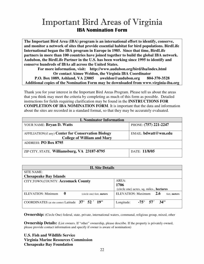
Important Bird Areas of Virginia IBA Nomination Form
The Important Bird Area (IBA) program is an international effort to identify, conserve,
and monitor a network of sites that provide essential habitat for bird populations. BirdLife
International began the IBA program in Europe in 1985. Since that time, BirdLife
partners in more than 100 countries have joined together to build the global IBA network.
Audubon, the BirdLife Partner in the U.S. has been working since 1995 to identify and
conserve hundreds of IBAs all across the United States.
For more information, visit: http://www.audubon.org/bird/iba/index.html
Or contact Aimee Weldon, the Virginia IBA Coordinator
P.O. Box 1089, Ashland, VA 23005 [email protected] 804-370-3528
Additional copies of the Nomination Form may be downloaded from www.virginia-iba.org
Thank you for your interest in the Important Bird Areas Program. Please tell us about the areas
that you think may meet the criteria by completing as much of this form as possible. Detailed
instructions for fields requiring clarification may be found in the INSTRUCTIONS FOR
COMPLETION OF IBA NOMINATION FORM. It is important that the data and information
about the sites are recorded in a standard format, so that they may be accurately evaluated.
I. Nominator Information
YOUR NAME: Bryan D. Watts PHONE: (757) 221-2247
AFFILIATION(if any) Center for Conservation Biology
College of William and Mary
EMAIL: [email protected]
ADDRESS: PO Box 8795
ZIP CITY, STATE, Williamsburg, VA 23187-8795 DATE: 11/8/05
II. Site Details SITE NAME:
Chesapeake Bay Islands
CITY,TOWN,COUNTY: Accomack County AREA:
1706 (circle one) acres, sq. miles., hectares
ELEVATION: Minimum 0 (circle one) feet, meters ELEVATION: Maximum 2.6 feet, meters
COORDINATES (at site center) Latitude 37° 52 ´ 19" Longitude: -75° 57´ 34"
Ownership: (Circle One) federal, state, private, international waters, communal, religious group, mixed, other
Ownership Details: (List owners. If “other” ownership, please describe. If the property is privately owned,
please provide contact information and specify if owner is aware of nomination)
U.S. Fish and Wildlife Service
Virginia Marine Resources Commission
Chesapeake Bay Foundation
23
Road Directions to site (or location /distance to nearest town) Please include a map if convenient.
24
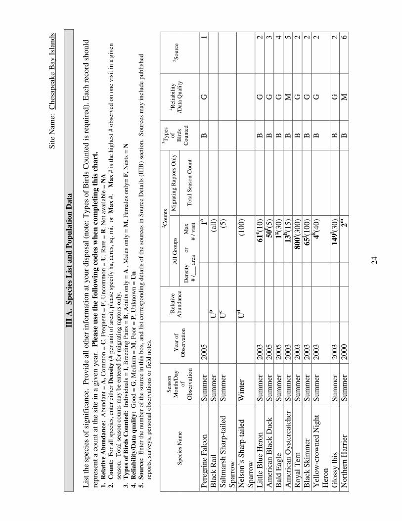
Sit
e N
ame:
C
hes
apea
ke
Bay I
slan
ds
III
A. S
pec
ies
Lis
t an
d P
op
ula
tion
Data
L
ist
the
spec
ies
of
signif
ican
ce. P
rovid
e al
l oth
er i
nfo
rmat
ion a
t your
dis
po
sal
(note
: T
yp
es o
f B
irds
Counte
d i
s re
quir
ed).
Eac
h r
ecord
should
repre
sent
a co
unt
at t
he
site
in a
giv
en y
ear.
P
lease
use
th
e fo
llow
ing c
od
es w
hen
com
ple
tin
g t
his
ch
art
.
1.
Rel
ati
ve
Ab
un
da
nce
: A
bund
ant
= A
, C
om
mo
n =
C,
Fre
quen
t =
F,
Unco
mm
on =
U,
Rar
e =
R,
No
t av
aila
ble
= N
A
2.
Co
un
t:
Fo
r al
l sp
ecie
s, e
nte
r ei
ther
Den
sity
(#
per
unit
of
area
), p
leas
e sp
ecif
y h
a, a
cres
, sq
. m
i.
or
Ma
x #
.
Ma
x #
is
the
hig
hest
# o
bse
rved
on o
ne
vis
it i
n a
giv
en
sea
son.
To
tal
seas
on c
ou
nts
may b
e en
tere
d f
or
mig
rati
ng r
apto
rs o
nly
.
3.
Ty
pes
of
Bir
ds
Co
un
ted
: I
nd
ivid
uals
= I
, B
reed
ing P
airs
= B
, A
dult
s o
nly
= A
, M
ales
only
= M
, F
em
ales
only
= F
, N
ests
= N
4.
Rel
iab
ilit
y/D
ata
qu
ali
ty:
Go
od
= G
, M
ediu
m =
M, P
oor
= P
, U
nkno
wn
= U
n
5.
So
urc
e:
Ente
r th
e nu
mb
er o
f th
e so
urc
e in
this
bo
x,
and
lis
t co
rres
po
nd
ing d
etai
ls o
f th
e so
urc
es i
n S
ourc
e D
etai
ls (
IIIB
) se
ctio
n.
So
urc
es m
ay i
ncl
ud
e p
ub
lish
ed
rep
ort
s, s
urv
eys,
per
sonal
ob
serv
atio
ns
or
fiel
d n
ote
s.
2C
ou
nts
All
Gro
up
s M
igra
tin
g R
apto
rs O
nly
S
pec
ies
Nam
e
Sea
son
Mo
nth
/Day
of
Ob
serv
atio
n
Yea
r o
f
Ob
serv
atio
n
1R
elat
ive
Ab
un
dan
ce
D
ensi
ty
o
r
M
ax
# /
___
are
a
#
/ v
isit
T
ota
l S
easo
n C
ou
nt
3T
yp
es
of
Bir
ds
Co
unte
d
4R
elia
bil
ity
/Dat
a Q
ual
ity
5S
ou
rce
Per
egri
ne
Fal
con
Sum
mer
2005
1a
B
G
1
Bla
ck R
ail
Sum
mer
Ub
(a
ll)
Sal
tmar
sh S
har
p-t
aile
d
Spar
row
Sum
mer
Uc
(5
)
Nel
son’s
Shar
p-t
aile
d
Spar
row
Win
ter
U
d
(1
00)
Lit
tle
Blu
e H
eron
Sum
mer
2003
61
e (10)
B
G
2
Am
eric
an B
lack
Duck
S
um
mer
2005
50
f (5)
B
G
3
Bal
d E
agle
S
um
mer
2005
1g(3
0)
B
G
4
Am
eric
an O
yst
erca
tcher
S
um
mer
2003
13
h(1
5)
B
M
5
Ro
yal
Ter
n
Sum
mer
2003
800
i (300)
B
G
2
Bla
ck S
kim
mer
S
um
mer
2003
65
j (100)
B
G
2
Yel
low
-cro
wned
Nig
ht
Her
on
Sum
mer
2003
4k(4
0)
B
G
2
Glo
ssy I
bis
S
um
mer
2003
149
l (30)
B
G
2
Nort
her
n H
arri
er
Sum
mer
2000
2m
B
M
6
25
Com
mon T
ern
Sum
mer
2003
90
n(2
00)
B
G
2
Bar
n O
wl
Sum
mer
2000
1o(5
)
B
P
6
Fors
ter’
s T
ern
Sum
mer
2003
390
p(5
0)
B
G
2
Sea
side
Spar
row
S
um
mer
2900
q(5
00)
B
M
7
aA
rea
support
s 5%
of
Vir
gin
ia b
reed
ing p
opula
tio
n. T
his
val
ue
has
flu
ctuat
ed i
n r
ecen
t p
ast
to a
s hig
h a
s 20
%. I
t is
lik
ely t
hat
this
are
a
support
s a
more
subst
anti
al w
inte
r popula
tion.
bS
tatu
s of
this
spec
ies
is n
ot
know
n w
ithin
the
area
. T
he
spec
ies
does
not
occ
ur
on W
atts
or
Gre
at F
ox
Isl
and. H
ow
ever
, li
mit
ed s
uit
able
hab
itat
is
avai
lable
in t
he
com
ple
x b
etw
een T
angie
r an
d S
mit
h I
slan
d.
c Sta
tus
of
this
spec
ies
is n
ot
know
n w
ithin
the
area
. T
he
spec
ies
does
not
occ
ur
on W
atts
Isl
and a
nd t
he
spec
ies
was
not
det
ecte
d d
uri
ng
exte
nsi
ve
fiel
d w
ork
on S
mit
h I
slan
d d
uri
ng t
he
sum
mer
of
2000. H
ow
ever
, li
mit
ed, su
itab
le h
abit
at i
s av
aila
ble
on T
angie
r an
d G
reat
Fox
Isla
nds.
dS
tatu
s of
this
spec
ies
is n
ot
know
n w
ithin
the
area
. B
ased
on a
vai
lable
hab
itat
it
seem
s li
kel
y t
hat
a w
inte
r popula
tion c
ould
be
support
ed t
hat
would
ex
ceed
the
stat
ed I
BA
thre
shold
. e A
rea
support
s 20%
of
Vir
gin
ia b
reed
ing p
opula
tion. I
n r
ecen
t dec
ades
, th
is a
rea
has
support
ed s
ignif
ican
t co
mm
unit
y o
f lo
ng-l
egged
wad
ers.
f A
rea
rep
rese
nts
one
of
the
few
rem
ainin
g s
tron
ghold
s fo
r th
e V
irgin
ia b
reed
ing p
opula
tion.
gA
rea
support
s a
smal
l fr
acti
on o
f th
e V
irgin
ia b
reed
ing p
opula
tion a
nd i
s n
ot
import
ant
for
this
spec
ies
duri
ng a
ny s
easo
n.
hA
rea
suppo
rts
appro
xim
atel
y 2
% o
f th
e know
n V
irgin
ia b
reed
ing p
opula
tion. H
ow
ever
, w
ork
in t
his
are
a duri
ng t
he
com
pre
hen
sive
surv
ey o
f
2003 w
as l
imit
ed. B
ased
on t
he
num
ber
of
roost
ing b
irds
late
in t
he
seas
on,
it s
eem
s hig
hly
lik
ely t
hat
this
are
a do
es e
xce
ed t
he
stat
ed I
BA
thre
shold
. i A
rea
support
s 28%
of
Vir
gin
ia b
reed
ing p
opula
tio
n. T
he
dis
trib
uti
on o
f th
is s
pec
ies
is d
yn
amic
over
tim
e.
j Are
a su
pport
s 4%
of
Vir
gin
ia b
reed
ing p
opula
tio
n. T
he
dis
trib
uti
on o
f th
is s
pec
ies
is d
yn
amic
over
tim
e su
ch t
hat
num
ber
s m
ay v
ary w
ithin
this
loca
tion m
ay v
ary o
ver
a w
ide
ran
ge
yea
r to
yea
r.
kA
rea
suppo
rts
appro
xim
atel
y 2
% o
f know
n V
irgin
ia b
reed
ing p
opula
tion.
Pai
rs n
est
in m
ixed
-spec
ies
her
onry
an
d n
um
ber
s hav
e dec
reas
ed i
n
rece
nt
yea
rs.
l Are
a su
pport
s 18%
of
Vir
gin
ia b
reed
ing p
opula
tio
n. O
ver
all
stat
e popula
tion i
n d
ecli
ne
but
sub-p
op
ula
tion i
n t
his
loca
tion a
nd i
n c
olo
nie
s to
the
nort
h i
n M
D a
ppea
r to
be
doin
g w
ell.
m
Tw
o p
airs
obse
rved
du
ring s
um
mer
of
2000 w
hil
e co
nduct
ing w
ork
on S
mit
h I
slan
d w
ith B
row
n P
elic
ans
(Wat
ts 2
000).
P
opula
tion w
ithin
this
are
a m
ay b
e as
much
as
twic
e th
is s
ize
but
not
more
. S
pec
ies
does
not
bre
ed o
n W
atts
or
Gre
at F
ox
isl
ands.
nA
rea
suppo
rts
nea
rly 5
% o
f V
irgin
ia b
reed
ing p
opula
tion.
oO
ne
pai
r obse
rved
du
rin
g t
he
sum
mer
of
2000 w
hil
e co
nduct
ing w
ork
on S
mit
h I
slan
d w
ith B
row
n P
elic
ans
(Wat
ts 2
000).
N
o s
yst
emat
ic
surv
ey o
f th
is s
pec
ies
wit
hin
the
area
but
bas
ed o
n a
vai
lable
fo
ragin
g h
abit
at a
nd s
truct
ure
s fo
r nes
tin
g i
t se
ems
unli
kel
y t
hat
the
area
wil
l
support
the
thre
shold
popula
tion s
ize.

26
pA
rea
suppo
rts
16%
of
Vir
gin
ia b
reed
ing p
opula
tion. B
reed
ing c
olo
nie
s hav
e bee
n r
elat
ivel
y s
table
thro
ugh t
ime.
qA
rea
suppo
rts
signif
ican
t bre
edin
g p
opula
tion. N
um
ber
is
a pro
ject
ion b
ased
on d
ensi
ty e
stim
ate
and a
vai
lable
hab
itat
.

27
Site Name: Chesapeake Bay Islands
III B. Source Details
Detail the sources of data noted in the “Species List and Population Data” (III A) Section.
If additional space is needed, you may attach copies of this form to the nomination.
1. Watts, B. D., Padgett, S. M., M. A. Byrd, and E. C. Long. 2005. Virginia Peregrine Falcon
monitoring and management program: Year 2005 report. Center for Conservation Biology
Technical Report Series, CCBTR-05-09. College of William and Mary, Williamsburg, VA. 12
pp.
2. Watts, B. D. 2004. Status and distribution of colonial waterbirds in coastal Virginia: 2003
breeding season. CCBTR-04-06. Center for Conservation Biology, College of William and
Mary, Williamsburg, VA 25 pp
3. Bidrowski, T. and G. Costanzo. 2005. Survey of breeding Black Ducks on selected bay
islands of Accomack County. Unpublished Data Virginia Department of Game and Inland
Fisheries. Richmond, VA.
4. Watts, B. D. and M. A. Byrd 2005. Virginia bald eagle nest and productivity survey: Year
2005 report. Center for Conservation Biology Technical Report Series, CCBTR-05-05. College
of William and Mary, Williamsburg, VA. 27 pp.
5. Wilke, A. L., B. D. Watts, B. R. Truitt, and R. Boettcher. 2005. Breeding season status of the
American Oystercatcher in Virginia, USA. Waterbirds 28:308-315.
6. Watts, B. D. 2000. A study of waterbirds in Shanks Creek: An investigation on Smith Island,
MD. Center for Conservation Biology Technical Report Series, CCBTR-00-12. College of
William and Mary, Williamsburg, VA. 30 pp.
7. Wilson, M. D. and B. D. Watts. Population projection of Seaside Sparrows within the
Delmarva bayside marshes. Unpublished analysis.
Site Name: Chesapeake Bay Islands
IV. IBA Criteria
Proposed State Level Criteria – Mark all that apply
See Instruction IV for Explanations of Criteria.
Code State Definition Mark all
criteria that
apply

28
D 1.
D 3.
D 4.
Endangered, threatened, or vulnerable species: The site sustains a
breeding or non-breeding population of one or more bird species, sub-
species, or isolated populations that is/are endangered, threatened or
vulnerable to extirpation.
The site contains a significant suite of species associated with a habitat
type that is representative, rare, or threatened in Virginia.
The site contains a significant concentration of one or more species
during the breeding season, winter, or during migration.
Yes
Yes
V. Habitat Details
See Instruction V for List of Habitats at both levels below.
Major vegetation community types Predominant plant species Cover %
Spartina alterniflora
Spartina patens
Distichlis spicata
1.
Salt Marsh
2.
3.
4.
Site Name: Chesapeake Bay Islands
VI. Land Use See Instruction VI for description of Land Uses. Mark each land use at the site, circle its predominance,
and (if known) provide an estimate of the percent cover at the site currently devoted to the land use. You
may enter brief notes to clarify some land uses. Detailed explanations of land uses should be reported in
Text Summary, section IX. Check Land Use Predominance Cover % Notes

29
Here
Agriculture 1. Row crops, small grains Major Minor Unknown
Agriculture 2. Grasslands (pasture, hay) Major Minor Unknown
X Fisheries/aquaculture Major Minor Unknown
Forestry Major Minor Unknown
Hunting Major Minor Unknown
Military Major Minor Unknown
X Nature Conservation / research Major Minor Unknown
Not utilized Major Minor Unknown
Other Major Minor Unknown
Tourism / recreation Major Minor Unknown
Unknown Major Minor Unknown
Urban / industrial / transport Major Minor Unknown
Water management Major Minor Unknown
VII. Threats See Instruction VII for description of Threat Codes. Indicate all threats and the relative level of the
threat by entering (L) Low, (M) Medium, (H) high, (U) Unknown in front of all that apply. You may
enter notes to clarify some threats. However, detailed explanations of threats should be reported in Text
Summary, section IX. Enter
L,M,H,U Threat Notes
L Abandonment/land management reduction
L Agricultural expansion/intensification
L Aquaculture/fisheries
L Burning of vegetation
L Dam/dyke/barrage construction/operations
L Disturbance to birds
L Draining wetlands
L Dredging/canal building (irrigation)
L Filling wetlands
L Forest grazing (by native or domestic herbivores)
L Groundwater extraction
L Industrialization/urbanization
L Infrastructure (roads, power lines, cell towers, etc.)
L Intensified forest management (please elaborate)
L Isolation/fragmentation
L Mineral/oil/peat extraction
H Natural events Loss of habitat to sea-level rise
H Nonnative (exotic) animal/plant introduction Loss of habitat to phragmites invasion
M Colonization by ground predators Islands must be kept predator free
L Other
L Pesticide application (non-agricultural)
L Plantation forestry (Afforestation) on previously open land
L Recreation/tourism
L Unsustainable exploitation of birds
Site Name: Chesapeake Bay Islands
VIII. Protected Areas
Complete only if this site contains or abuts protected area(s)!

30
Enter name and descriptions of protected areas contained within or adjacent to this site.
See Instruction VIII
1. Name of protected area:
Chesapeake Bay Foundation Designation: Area: circle one: hectares, acres, sq.
miles
334.7 Relationship: Circle one Protected area contains IBA, Is adjacent to IBA,
Is contained by IBA, Overlaps with IBA,
Unknown
Overlap: circle one: hectares, acres, sq.
miles
334.7
2. Name of protected area:
State Common Lands – Virginia Marine Resources Commission Designation: Area: circle one: hectares, acres, sq.
miles
156.8 Relationship: Circle one Protected area contains IBA, Is adjacent to IBA,
Is contained by IBA, Overlaps with IBA,
Unknown
Overlap: circle one: hectares, acres, sq.
miles
156.8
3. Name of protected area:
Watts Island – U.S. Fish and Wildlife Service Designation: Area: circle one: hectares, acres, sq.
miles
100.2 Relationship: Circle one Protected area contains IBA, Is adjacent to IBA,
Is contained by IBA, Overlaps with IBA,
Unknown
Overlap: circle one: hectares, acres, sq.
miles
100.2
IX. Text Summary
Use the following space for additional descriptions of site details.
General Site Description: The Chesapeake Bay Islands IBA includes 4 major island complexes
including Tangier, the southern end of Smith, Great Fox, and Watts. Tangier and Smith are
connected by a sandy ridge or barrier. These islands are isolated from the mainland by
substantial distances and have generally been predator free making them attractive to nesting
water birds. The islands are primarily marsh with topographic highs or berms along the west-
facing margins. The islands also have both natural and dredge-spoil hummocks colonized by
shrubs and loblolly pines.
General Ornithological Information: Two benchmark surveys of colonial waterbirds (1993
and 2003) have been conducted throughout the area to determine status and distribution and to
place the area in context with other areas throughout coastal Virginia. Various portions of this
area have been surveyed for breeding Black Ducks by Virginia Department of Game and Inland
Fisheries biologists for several years. Peregrine Falcon pairs have been monitored within the
area since the first nesting in 1983. Surrounding waters support exceptional numbers of

31
wintering seaducks. Shorebirds certainly migrate along these islands but no definitive
information has been collected.
Research / conservation projects: Several projects have been conducted within this complex
over the years. A banding and monitoring project has been ongoing with the Brown Pelican
colony on Smith Island since the early 1990s. Great Fox Island was one of the early hack sites
for Peregrine Falcons in Virginia. Some attempts to protect Tangier and Smith islands from
erosion have been made. The tern and gull colony on Great Fox Island is generally observed and
protected by the Chesapeake Bay Foundation. Osprey management has been ongoing on Smith
Island since the late 1960s. The U.S. Fish and Wildlife Service has acted to reduce illegal
waterfowl harvest in the area for years.
Habitat / Land Use: The dominant habitat type throughout the islands is tidal salt marsh.
Interspersed within these marshes are vegetated hummocks. Watts Island is primarily a high
ridge of loblolly forest with some surrounding marsh. Great Fox Island is almost entirely marsh
with a high sand berm along the margin. Tangier Island has extensive marsh habitat but also has
considerable high ground where the town, airport, and harbor are located. The southern end of
Smith Island is marsh with a long, narrow barrier island extending south. Fishing and crabbing
are the basis of the island economies so waterman work the areas around all of the islands.
Other Flora / Fauna:
Protected Areas: A considerable portion of the area within the islands is privately owned.
Watts Island has recently been acquired by the U.S. Fish and Wildlife Service and annexed to the
Blackwater National Wildlife Refuge. The Chesapeake Bay Foundation owns the educational
facility on Great Fox Island and some additional land on both Tangier and Smith. The Virginia
Marine Resources Commission has control over a small area of state common lands.
Threats: The primary threat to this system is the loss of habitat due to erosion. All of the
islands have lost considerable area in recent memory. The Bay has lost many islands over the
past several decades to erosion and this process is continuing. Given the important role that
these islands play for sensitive bird species, efforts should be made to protect them from further
losses where possible. An additional threat is the colonization of the islands by predators.
Ground predators such as raccoons, fox, feral cats, and Norway rats are capable of rendering
these islands unusable by ground nesters. In addition, continued expansion of the Herring and
Great Black-backed populations on these islands may be displacing other species or reducing
reproductive rates. The gull colony formed on Watts Island in 2002 and has grown dramatically
since that time. Threats from human disturbance seem to be limited at this time.
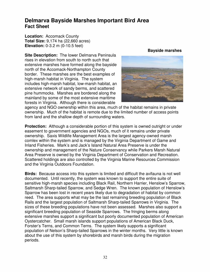
32
Delmarva Bayside Marshes Important Bird Area Fact Sheet Location: Accomack County Total Size: 9,174 ha (22,660 acres) Elevation: 0-3.2 m (0-10.5 feet) Site Description: The lower Delmarva Peninsula rises in elevation from south to north such that extensive marshes have formed along the bayside north of the Accomack-Northampton County border. These marshes are the best examples of high-marsh habitat in Virginia. The system includes high-marsh habitat, low-marsh habitat, an extensive network of sandy berms, and scattered pine hummocks. Marshes are bordered along the mainland by some of the most extensive maritime forests in Virginia. Although there is considerable agency and NGO ownership within this area, much of the habitat remains in private ownership. Much of the habitat is remote due to the limited number of access points from land and the shallow depth of surrounding waters. Protection: Although a considerable portion of this system is owned outright or under easement to government agencies and NGOs, much of it remains under private ownership. Saxis Wildlife Management Area is the largest agency-owned marsh comlex within the system and is managed by the Virginia Department of Game and Inland Fisheries. Mark’s and Jack’s Island Natural Area Preserve is under the ownership and management of the Nature Conservancy while Parkers Marsh Natural Area Preserve is owned by the Virginia Department of Conservation and Recreation. Scattered holdings are also controlled by the Virginia Marine Resources Commission and the Virginia Outdoors Foundation. Birds: Because access into this system is limited and difficult the avifauna is not well documented. Until recently, the system was known to support the entire suite of sensitive high-marsh species including Black Rail, Northern Harrier, Henslow’s Sparrow, Saltmarsh Sharp-tailed Sparrow, and Sedge Wren. The known population of Henslow’s Sparrow has been lost in recent years likely due to degradation of habitat by common reed. The area supports what may be the last remaining breeding population of Black Rails and the largest population of Saltmarsh Sharp-tailed Sparrows in Virginia. The sizes of these breeding populations have not been assessed. Marshes also support a significant breeding population of Seaside Sparrows. The fringing berms along extensive marshes support a significant but poorly documented population of American Oystercatcher. Small marsh islands support populations of American Black Duck, Forster’s Terns, and Common Terns. The system likely supports a significant population of Nelson’s Sharp-tailed Sparrows in the winter months. Very little is known about the use of this system by shorebirds and marsh birds during the migration periods.
Bayside marshes
33
Conservation and Threats: Primary threats to bird populations within this system include 1) loss of habitat to the invasion by common reed, 2) loss of habitat to sea-level rise, and 3) increases in mammal populations and associated predation. The aggressive invasive plant common reed is spreading rapidly throughout this system from a substantial source population that has formed at Saxis Wildlife Management Area. This species invades along the marsh-upland ecotone and eliminates habitat required by the Henslow’s Sparrow. This is likely the primary cause of the loss of this species from this habitat along the Atlantic Coast. Habitat continues to be at risk in the long term to rising sea levels. The increase in mammal predators (raccoon and both fox species) over the past 30 years on the Delmarva mainland has almost certainly had a detrimental effect on reproductive rates of marsh-bird populations. To date, this area has received very little attention from the conservation community.
34
Important Bird Areas of Virginia IBA Nomination Form
The Important Bird Area (IBA) program is an international effort to identify, conserve,
and monitor a network of sites that provide essential habitat for bird populations. BirdLife
International began the IBA program in Europe in 1985. Since that time, BirdLife
partners in more than 100 countries have joined together to build the global IBA network.
Audubon, the BirdLife Partner in the U.S. has been working since 1995 to identify and
conserve hundreds of IBAs all across the United States.
For more information, visit: http://www.audubon.org/bird/iba/index.html
Or contact Aimee Weldon, the Virginia IBA Coordinator
P.O. Box 1089, Ashland, VA 23005 [email protected] 804-370-3528
Additional copies of the Nomination Form may be downloaded from www.virginia-iba.org
Thank you for your interest in the Important Bird Areas Program. Please tell us about the areas
that you think may meet the criteria by completing as much of this form as possible. Detailed
instructions for fields requiring clarification may be found in the INSTRUCTIONS FOR
COMPLETION OF IBA NOMINATION FORM. It is important that the data and information
about the sites are recorded in a standard format, so that they may be accurately evaluated.
I. Nominator Information
YOUR NAME: Bryan D. Watts PHONE: (757) 221-2247
AFFILIATION(if any) Center for Conservation Biology
College of William and Mary
EMAIL: [email protected]
ADDRESS: PO Box 8795
ZIP CITY, STATE, Williamsburg, VA 23187-8795 DATE: 11/8/05
II. Site Details
SITE NAME: Delmarva Bayside Marshes
CITY,TOWN,COUNTY: Accomack AREA:
9174.3 (circle one) acres, sq. miles., hectares
ELEVATION: Minimum 0 (circle one) feet, meters ELEVATION: Maximum 3.2 feet, meters
COORDINATES (at site center) Latitude 37° 52´ 19” Longitude: -75 ° 44´ 58"
Ownership: (Circle One) federal, state, private, international waters, communal, religious group, mixed, other
Ownership Details: (List owners. If “other” ownership, please describe. If the property is privately owned,
please provide contact information and specify if owner is aware of nomination)
Virginia Department of Game and Inland Fisheries
Virginia Department of Conservation and Recreation
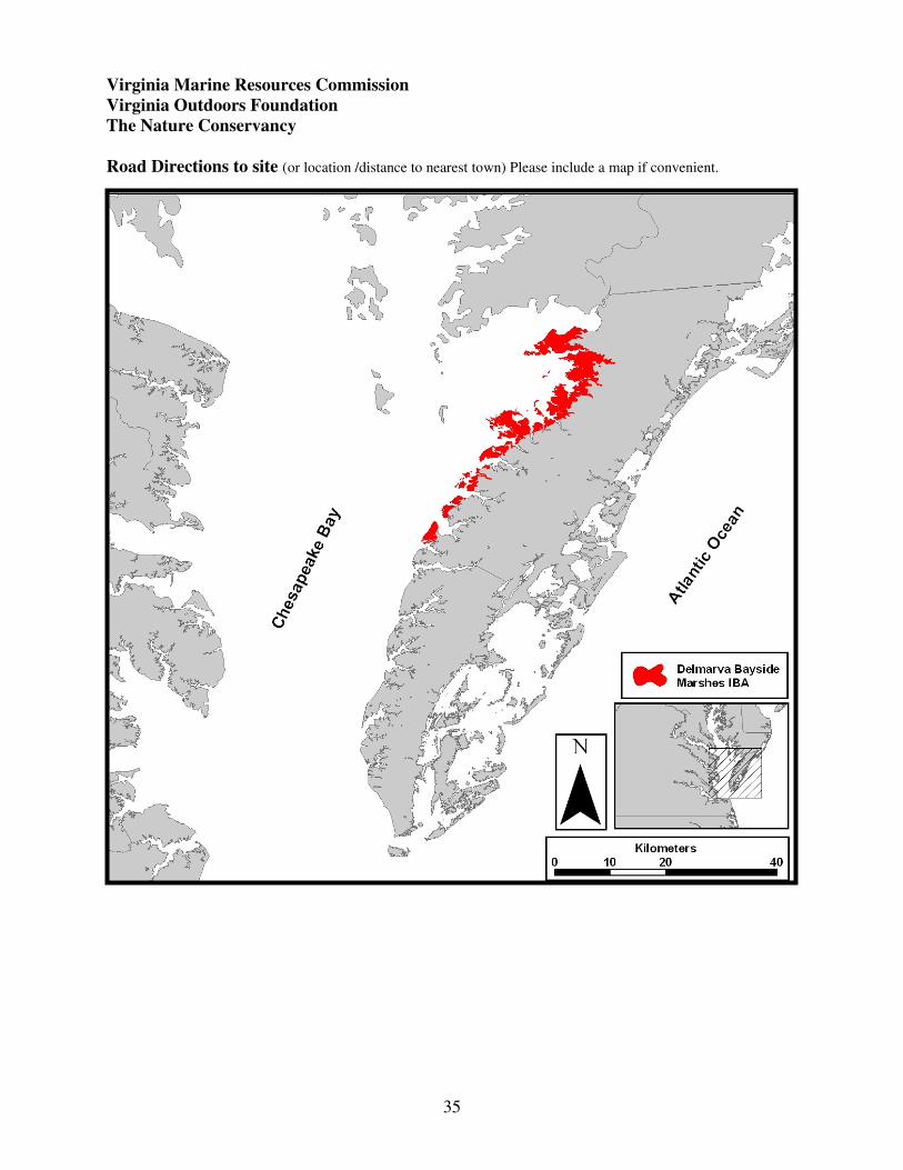
35
Virginia Marine Resources Commission
Virginia Outdoors Foundation
The Nature Conservancy
Road Directions to site (or location /distance to nearest town) Please include a map if convenient.
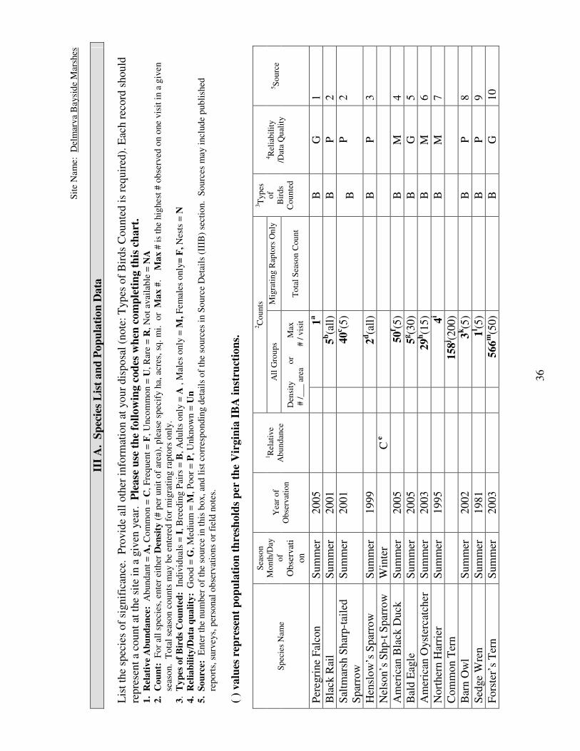
36
Sit
e N
am
e:
Del
mar
va
Baysi
de
Mar
shes
III
A. S
pec
ies
Lis
t an
d P
op
ula
tion
Data
L
ist
the
spec
ies
of
signif
ican
ce. P
rovid
e al
l oth
er i
nfo
rmat
ion a
t your
dis
po
sal
(note
: T
yp
es o
f B
irds
Counte
d i
s re
quir
ed).
Eac
h r
ecord
should
repre
sent
a co
unt
at t
he
site
in a
giv
en y
ear.
P
lease
use
th
e fo
llow
ing c
od
es w
hen
com
ple
tin
g t
his
ch
art
.
1.
Rel
ati
ve
Ab
un
da
nce
: A
bund
ant
= A
, C
om
mo
n =
C,
Fre
quen
t =
F,
Unco
mm
on =
U,
Rar
e =
R,
No
t av
aila
ble
= N
A
2.
Co
un
t:
Fo
r al
l sp
ecie
s, e
nte
r ei
ther
Den
sity
(#
per
unit
of
area
), p
leas
e sp
ecif
y h
a, a
cres
, sq
. m
i.
or
Ma
x #
.
Ma
x #
is
the
hig
hest
# o
bse
rved
on o
ne
vis
it i
n a
giv
en
sea
son.
To
tal
seas
on c
ou
nts
may b
e en
tere
d f
or
mig
rati
ng r
apto
rs o
nly
.
3.
Ty
pes
of
Bir
ds
Co
un
ted
: I
nd
ivid
uals
= I
, B
reed
ing P
airs
= B
, A
dult
s o
nly
= A
, M
ales
only
= M
, F
em
ales
only
= F
, N
ests
= N
4.
Rel
iab
ilit
y/D
ata
qu
ali
ty:
Go
od
= G
, M
ediu
m =
M, P
oor
= P
, U
nkno
wn
= U
n
5.
So
urc
e:
Ente
r th
e nu
mb
er o
f th
e so
urc
e in
this
bo
x,
and
lis
t co
rres
po
nd
ing d
etai
ls o
f th
e so
urc
es i
n S
ourc
e D
etai
ls (
IIIB
) se
ctio
n.
So
urc
es m
ay i
ncl
ud
e p
ub
lish
ed
rep
ort
s, s
urv
eys,
per
sonal
ob
serv
atio
ns
or
fiel
d n
ote
s.
( )
valu
es r
epre
sen
t p
op
ula
tion
th
resh
old
s p
er t
he
Vir
gin
ia I
BA
in
stru
ctio
ns.
2C
ou
nts
All
Gro
up
s M
igra
tin
g R
apto
rs O
nly
S
pec
ies
Nam
e
Sea
son
Mo
nth
/Day
of
Ob
serv
ati
on
Yea
r o
f
Ob
serv
atio
n
1R
elat
ive
Ab
un
dan
ce
D
ensi
ty
o
r
M
ax
# /
___
are
a
#
/ v
isit
T
ota
l S
easo
n C
ou
nt
3T
yp
es
of
Bir
ds
Co
unte
d
4R
elia
bil
ity
/Dat
a Q
ual
ity
5S
ou
rce
Per
egri
ne
Fal
con
Sum
mer
2005
1a
B
G
1
Bla
ck R
ail
Sum
mer
2001
5b(a
ll)
B
P
2
Sal
tmar
sh S
har
p-t
aile
d
Spar
row
Sum
mer
2001
40
c (5)
B
P
2
Hen
slow
’s S
par
row
S
um
mer
1999
2d(a
ll)
B
P
3
Nel
son’s
Shp-t
Spar
row
W
inte
r
C e
Am
eric
an B
lack
Duck
S
um
mer
2005
50
f (5)
B
M
4
Bal
d E
agle
S
um
mer
2005
5g(3
0)
B
G
5
Am
eric
an O
yst
erca
tcher
S
um
mer
2003
29
h(1
5)
B
M
6
Nort
her
n H
arri
er
Sum
mer
1995
4i
B
M
7
Com
mon T
ern
158
j (200)
Bar
n O
wl
Sum
mer
2002
3k(5
)
B
P
8
Sed
ge
Wre
n
Sum
mer
1981
1l (5
)
B
P
9
Fors
ter’
s T
ern
Sum
mer
2003
566
m(5
0)
B
G
10
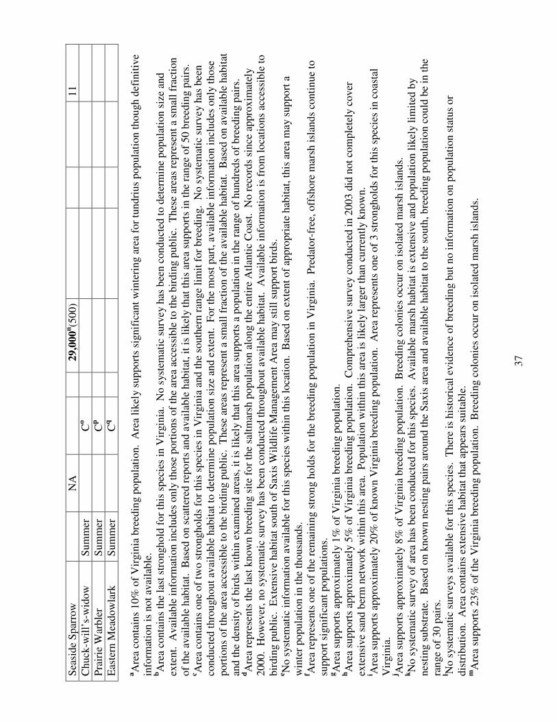
37
Sea
side
Spar
row
NA
29,0
00
n(5
00)
11
Chuck
-wil
l’s-
wid
ow
S
um
mer
Co
Pra
irie
War
ble
r S
um
mer
Cp
Eas
tern
Mea
dow
lark
S
um
mer
Cq
aA
rea
conta
ins
10%
of
Vir
gin
ia b
reed
ing p
opula
tion. A
rea
likel
y s
upport
s si
gnif
ican
t w
inte
ring a
rea
for
tundri
us
popula
tion t
hough d
efin
itiv
e
info
rmat
ion i
s not
avai
lable
. bA
rea
conta
ins
the
last
str
onghold
fo
r th
is s
pec
ies
in V
irgin
ia. N
o s
yst
emat
ic s
urv
ey h
as b
een c
ondu
cted
to d
eter
min
e popula
tion s
ize
and
exte
nt.
A
vai
lable
info
rmat
ion i
ncl
udes
only
those
port
ions
of
the
area
acc
essi
ble
to t
he
bir
din
g p
ubli
c. T
hes
e ar
eas
rep
rese
nt
a sm
all
frac
tion
of
the
avai
lable
hab
itat
. B
ased
on s
catt
ered
rep
ort
s an
d a
vai
lable
hab
itat
, it
is
likel
y t
hat
this
are
a su
pport
s in
the
ran
ge
of
50 b
reed
ing p
airs
. c A
rea
conta
ins
on
e of
two s
tronghold
s fo
r th
is s
pec
ies
in V
irgin
ia a
nd t
he
south
ern r
ange
lim
it f
or
bre
edin
g. N
o s
yst
emat
ic s
urv
ey h
as b
een
conduct
ed t
hro
ughout
avai
lable
hab
itat
to d
eter
min
e popula
tion s
ize
and e
xte
nt.
F
or
the
most
par
t, a
vai
lable
info
rmat
ion i
ncl
udes
only
those
port
ions
of
the
area
acc
essi
ble
to t
he
bir
din
g p
ubli
c. T
hes
e ar
eas
rep
rese
nt
a sm
all
frac
tion o
f th
e av
aila
ble
hab
itat
. B
ased
on
avai
lable
hab
itat
and t
he
den
sity
of
bir
ds
wit
hin
ex
amin
ed a
reas
, it
is
likel
y t
hat
this
are
a su
pport
s a
popula
tion i
n t
he
ran
ge
of
hund
reds
of
bre
edin
g p
airs
. dA
rea
repre
sents
the
last
know
n b
reed
ing s
ite
for
the
salt
mar
sh p
opula
tion a
long t
he
enti
re A
tlan
tic
Coas
t. N
o r
ecord
s si
nce
appro
xim
atel
y
2000. H
ow
ever
, no s
yst
emat
ic s
urv
ey h
as b
een c
onduct
ed t
hro
ughout
avai
lable
hab
itat
. A
vai
lable
info
rmat
ion i
s fr
om
loca
tions
acce
ssib
le t
o
bir
din
g p
ubli
c. E
xte
nsi
ve
hab
itat
south
of
Sax
is W
ildli
fe M
anag
emen
t A
rea
may s
till
support
bir
ds.
e N
o s
yst
emat
ic i
nfo
rmat
ion a
vai
lable
fo
r th
is s
pec
ies
wit
hin
this
loca
tion. B
ased
on e
xte
nt
of
appro
pri
ate
hab
itat
, th
is a
rea
may
suppo
rt a
win
ter
popula
tion i
n t
he
thousa
nds.
f A
rea
rep
rese
nts
one
of
the
rem
ainin
g s
tron
g h
old
s fo
r th
e bre
edin
g p
opula
tion i
n V
irgin
ia. P
redat
or-
free
, off
shore
mar
sh i
slan
ds
conti
nue
to
support
sig
nif
ican
t popula
tions.
gA
rea
support
s ap
pro
xim
atel
y 1
% o
f V
irgin
ia b
reed
ing p
opula
tion.
hA
rea
suppo
rts
appro
xim
atel
y 5
% o
f V
irgin
ia b
reed
ing p
opula
tion. C
om
pre
hen
sive
surv
ey c
onduct
ed i
n 2
003 d
id n
ot
com
ple
tely
cover
exte
nsi
ve
sand b
erm
net
work
wit
hin
this
are
a. P
opula
tion w
ithin
this
are
a is
lik
ely l
arger
than
cu
rren
tly k
now
n.
i Are
a su
pport
s ap
pro
xim
atel
y 2
0%
of
know
n V
irgin
ia b
reed
ing p
opula
tion.
Are
a re
pre
sents
one
of
3 s
tronghold
s fo
r th
is s
pec
ies
in c
oas
tal
Vir
gin
ia.
j Are
a su
pport
s ap
pro
xim
atel
y 8
% o
f V
irgin
ia b
reed
ing p
opula
tion. B
reed
ing c
olo
nie
s o
ccur
on i
sola
ted m
arsh
isl
ands.
kN
o s
yst
emat
ic s
urv
ey o
f ar
ea h
as b
een c
onduct
ed f
or
this
spec
ies.
A
vai
lable
mar
sh h
abit
at i
s ex
tensi
ve
and p
opula
tion l
ikel
y l
imit
ed b
y
nes
ting s
ubst
rate
. B
ased
on k
now
n n
esti
ng p
airs
aro
und t
he
Sax
is a
rea
and a
vai
lable
hab
itat
to t
he
south
, bre
edin
g p
opula
tion c
ould
be
in t
he
ran
ge
of
30 p
airs
.
l No s
yst
emat
ic s
urv
eys
avai
lable
for
this
spec
ies.
T
her
e is
his
tori
cal
evid
ence
of
bre
edin
g b
ut
no i
nfo
rmat
ion o
n p
opula
tion s
tatu
s or
dis
trib
uti
on. A
rea
conta
ins
exte
nsi
ve
hab
itat
that
appea
rs s
uit
able
. m
Are
a su
pport
s 23%
of
the
Vir
gin
ia b
reed
ing p
op
ula
tion. B
reed
ing c
olo
nie
s occ
ur
on i
sola
ted m
arsh
isl
ands.

38
n A
rea
support
s si
gnif
ican
t bre
edin
g p
opula
tion. N
um
ber
is
a pro
ject
ion b
ased
on d
ensi
ty e
stim
ate
and a
vai
lable
hab
itat
. oN
o s
yst
emat
ic s
urv
ey f
or
this
spec
ies.
T
he
spec
ies
is c
om
mon w
ithin
the
pin
e hum
mock
s an
d s
tand
s w
her
e hig
h g
round i
s av
aila
ble
.
pN
o s
yst
emat
ic s
urv
ey f
or
this
spec
ies.
C
om
mon b
reed
er w
ithin
most
pat
ches
of
hig
h m
arsh
. P
opula
tion i
s li
kel
y i
n t
he
ran
ge
of
sever
al
hundre
d p
airs
.
qN
o s
yst
emat
ic s
urv
ey f
or
this
spec
ies.
C
om
mon b
reed
ing s
pec
ies
wit
hin
most
pat
ches
of
hig
h m
arsh
.

39
Site Name: Delmarva Bayside Marshes
III B. Source Details
Detail the sources of data noted in the “Species List and Population Data” (III A) Section.
If additional space is needed, you may attach copies of this form to the nomination.
1. Watts, B. D., Padgett, S. M., M. A. Byrd, and E. C. Long. 2005. Virginia Peregrine Falcon
monitoring and management program: Year 2005 report. Center for Conservation Biology
Technical Report Series, CCBTR-05-09. College of William and Mary, Williamsburg, VA. 12
pp.
2. Watts, B. D. and B. J. Paxton. 2001. Observations in two marsh patches on the bayside of
Accomack County in preparation for marsh fragmentation study. Unpublished Data.
3. Watts, B. D. 2000. Observations within switch grass along the marsh-upland ecotone in Saxis
Marsh.
4. Bidrowski, T. and G. Costanzo. 2005. Survey of breeding Black Ducks on selected bay
islands of Accomack County. Unpublished Data Virginia Department of Game and Inland
Fisheries. Richmond, VA.
5. Watts, B. D. and M. A. Byrd 2005. Virginia bald eagle nest and productivity survey: Year
2005 report. Center for Conservation Biology Technical Report Series, CCBTR-05-05. College
of William and Mary, Williamsburg, VA. 27 pp.
6. Wilke, A. L., B. D. Watts, B. R. Truitt, and R. Boettcher. 2005. Breeding season status of the
American Oystercatcher in Virginia, USA. Waterbirds 28:308-315.
7. Watts, B. D. and S. J. Rottenborn. 2001. Breeding status of Northern Harriers in coastal
Virginia. The Raven 72:153-157.
8. Watts, B. D. 2002. Field observations of barn owls in duck blind, Peregrine tower, and Barn
Owl box in the Saxis area. Unpublished Data.
9. Kinzie, B. L. and F. R. Scott. 1983. The Accomack County Breeding-Bird Foray of 1981.
The Raven 54:3-18.
10. Watts, B. D. 2004. Status and distribution of colonial waterbirds in coastal Virginia: 2003
breeding season. CCBTR-04-06. Center for Conservation Biology, College of William and
Mary, Williamsburg, VA 25 pp
11. Wilson, M. D. and B. D. Watts. Population projection of Seaside Sparrows within the
Delmarva bayside marshes. Unpublished analysis.

40
Site Name: Delmarva Bayside Marshes
IV. IBA Criteria
Proposed State Level Criteria – Mark all that apply
See Instruction IV for Explanations of Criteria.
Code State Definition Mark all
criteria that
apply
D 1.
D 3.
D 4.
Endangered, threatened, or vulnerable species: The site sustains a
breeding or non-breeding population of one or more bird species, sub-
species, or isolated populations that is/are endangered, threatened or
vulnerable to extirpation.
The site contains a significant suite of species associated with a habitat
type that is representative, rare, or threatened in Virginia.
The site contains a significant concentration of one or more species
during the breeding season, winter, or during migration.
Yes
Yes
V. Habitat Details
See Instruction V for List of Habitats at both levels below.
Major vegetation community types Predominant plant species Cover %
Spartina alterniflora
Spartina patens
Distichlis spicata
1.
Salt Marsh
Loblolly Pine
Wax Myrtle
2.
Pine Savannah Hummocks
3.
4.

41
Site Name: Delmarva Bayside Marshes
VI. Land Use See Instruction VI for description of Land Uses. Mark each land use at the site, circle its predominance,
and (if known) provide an estimate of the percent cover at the site currently devoted to the land use. You
may enter brief notes to clarify some land uses. Detailed explanations of land uses should be reported in
Text Summary, section IX. Check
Here Land Use Predominance Cover % Notes
Agriculture 1. Row crops, small grains Major Minor Unknown
Agriculture 2. Grasslands (pasture, hay) Major Minor Unknown
X Fisheries/aquaculture Major Minor Unknown
Forestry Major Minor Unknown
X Hunting Major Minor Unknown
Military Major Minor Unknown
X Nature Conservation / research Major Minor Unknown
Not utilized Major Minor Unknown
Other Major Minor Unknown
Tourism / recreation Major Minor Unknown
Unknown Major Minor Unknown
Urban / industrial / transport Major Minor Unknown
Water management Major Minor Unknown
VII. Threats See Instruction VII for description of Threat Codes. Indicate all threats and the relative level of the
threat by entering (L) Low, (M) Medium, (H) high, (U) Unknown in front of all that apply. You may
enter notes to clarify some threats. However, detailed explanations of threats should be reported in Text
Summary, section IX. Enter
L,M,H,U Threat Notes
L Abandonment/land management reduction
L Agricultural expansion/intensification
L Aquaculture/fisheries
L Burning of vegetation
L Dam/dyke/barrage construction/operations
L Disturbance to birds
L Draining wetlands
L Dredging/canal building (irrigation)
L Filling wetlands
L Forest grazing (by native or domestic herbivores)
L Groundwater extraction
L Industrialization/urbanization
L Infrastructure (roads, power lines, cell towers, etc.)
L Intensified forest management (please elaborate)
L Isolation/fragmentation
L Mineral/oil/peat extraction
H Natural events Habitat loss due to sea-level rise
H Nonnative (exotic) animal/plant introduction Loss of high-marsh habitat due to Phrag
H Other Predation by mammals
L Pesticide application (non-agricultural)
L Plantation forestry (Afforestation) on previously open land
L Recreation/tourism

42
L Unsustainable exploitation of birds
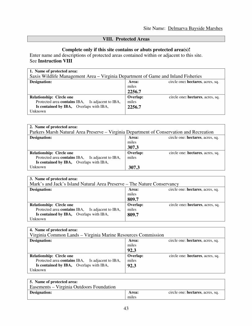
43
Site Name: Delmarva Bayside Marshes
VIII. Protected Areas
Complete only if this site contains or abuts protected area(s)! Enter name and descriptions of protected areas contained within or adjacent to this site.
See Instruction VIII
1. Name of protected area:
Saxis Wildlife Management Area – Virginia Department of Game and Inland Fisheries Designation: Area: circle one: hectares, acres, sq.
miles
2256.7 Relationship: Circle one Protected area contains IBA, Is adjacent to IBA,
Is contained by IBA, Overlaps with IBA,
Unknown
Overlap: circle one: hectares, acres, sq.
miles
2256.7
2. Name of protected area:
Parkers Marsh Natural Area Preserve – Virginia Department of Conservation and Recreation Designation: Area: circle one: hectares, acres, sq.
miles
307.3 Relationship: Circle one Protected area contains IBA, Is adjacent to IBA,
Is contained by IBA, Overlaps with IBA,
Unknown
Overlap: circle one: hectares, acres, sq.
miles
307.3
3. Name of protected area:
Mark’s and Jack’s Island Natural Area Preserve – The Nature Conservancy Designation: Area: circle one: hectares, acres, sq.
miles
809.7 Relationship: Circle one Protected area contains IBA, Is adjacent to IBA,
Is contained by IBA, Overlaps with IBA,
Unknown
Overlap: circle one: hectares, acres, sq.
miles
809.7
4. Name of protected area:
Virginia Common Lands – Virginia Marine Resources Commission Designation: Area: circle one: hectares, acres, sq.
miles
92.3 Relationship: Circle one Protected area contains IBA, Is adjacent to IBA,
Is contained by IBA, Overlaps with IBA,
Unknown
Overlap: circle one: hectares, acres, sq.
miles
92.3
5. Name of protected area:
Easements – Virginia Outdoors Foundation Designation: Area: circle one: hectares, acres, sq.
miles

44
11.7 Relationship: Circle one Protected area contains IBA, Is adjacent to IBA,
Is contained by IBA, Overlaps with IBA,
Unknown
Overlap: circle one: hectares, acres, sq.
miles
11.7
IX. Text Summary
Use the following space for additional descriptions of site details.
General Site Description: The extensive marshes of the Delmarva bayside are the best
examples of high-marsh habitat in Virginia and until recently were known to support the entire
suite of sensitive high-marsh species including Black Rail, Northern Harrier, Henslow’s
Sparrow, Saltmarsh Sharp-tailed Sparrow, and Sedge Wren. The system includes high-marsh
habitat, low-marsh habitat, an extensive network of sandy berms, and scattered pine hummocks.
Although there is considerable agency and NGO ownership within this area, much of the habitat
remains in private ownership. Much of the habitat is remote and not easily accessible to humans.
General Ornithological Information: This area is one of the last frontiers for ornithological
exploration in the coastal plain of Virginia. Due to the low number of upland access points and
the shallow waters surrounding many patches, definitive information on some of the species of
highest conservation concern is very limited. No definitive work on the high-marsh community
has been conducted. Information on this community is available for the few locations with road
access which represent a small fraction of the area. The site supported the last known breeding
location for Henslow’s Sparrows in traditional marsh habitat along the Atlantic Coast. Of note is
the long-term (30 years) data set on breeding Bald Eagles, two benchmark surveys of colonial
waterbirds (1993 and 2003), monitoring of Black Duck populations on selected marsh islands,
and an attempt to survey American Oystercatchers in 2003. Much work is needed to clarify
population status and distribution of marsh-nesting species and the use of the area by migrant
shorebirds.
Research / conservation projects: Comparatively little work is being or has been conducted
within this system. Black Duck breeding work continues to be conducted by Virginia
Department of Game and Inland Fisheries biologists. The Center for Conservation Biology
along with the Virginia Department of Game and Inland Fisheries established several nest boxes
for Barn Owls to encourage breeding. The Center for Conservation Biology recently completed
a study of the response of high-marsh species to patch size. Easement and acquisition efforts are
progressing.
Habitat / Land Use: The dominant habitat type within this area is salt marsh with high and low
components. The area also contains an extensive network of sandy berms along the Bay margin
and scattered pine and shrub hummocks. Very significant for the breeding bird community are
the small, marsh islets in the nearshore areas.
Other Flora / Fauna:
Protected Areas: Although a considerable portion of this system is owned outright or under
easement to government agencies and NGOs, much of it remains under private ownership.

45
Holders include the Virginia Department of Game and Inland Fisheries, The Virginia
Department of Conservation and Recreation, the Virginia Marine Resources Commission, The
Nature Conservancy, and the Virginia Outdoors Foundation.
Threats: Primary threats relevant to bird population include 1) loss of habitat to the invasion by
common reed, 2) loss of habitat to sea-level rise, and 3) increases in mammal populations and
associated predation. The aggressive invasive plant common reed is spreading rapidly
throughout this system from a substantial source population that has formed at Saxis Wildlife
Management Area. This species invades along the marsh-upland ecotone and eliminates habitat
required by the Henslow’s Sparrow. This is likely the primary cause of the loss of this species
from this habitat along the Atlantic Coast. Habitat continues to be at risk in the long term to
rising sea levels. The increase in mammal predators (raccoon and both fox species) over the past
30 years on the Delmarva mainland has almost certainly had a detrimental effect on reproductive
rates of marsh-bird populations.
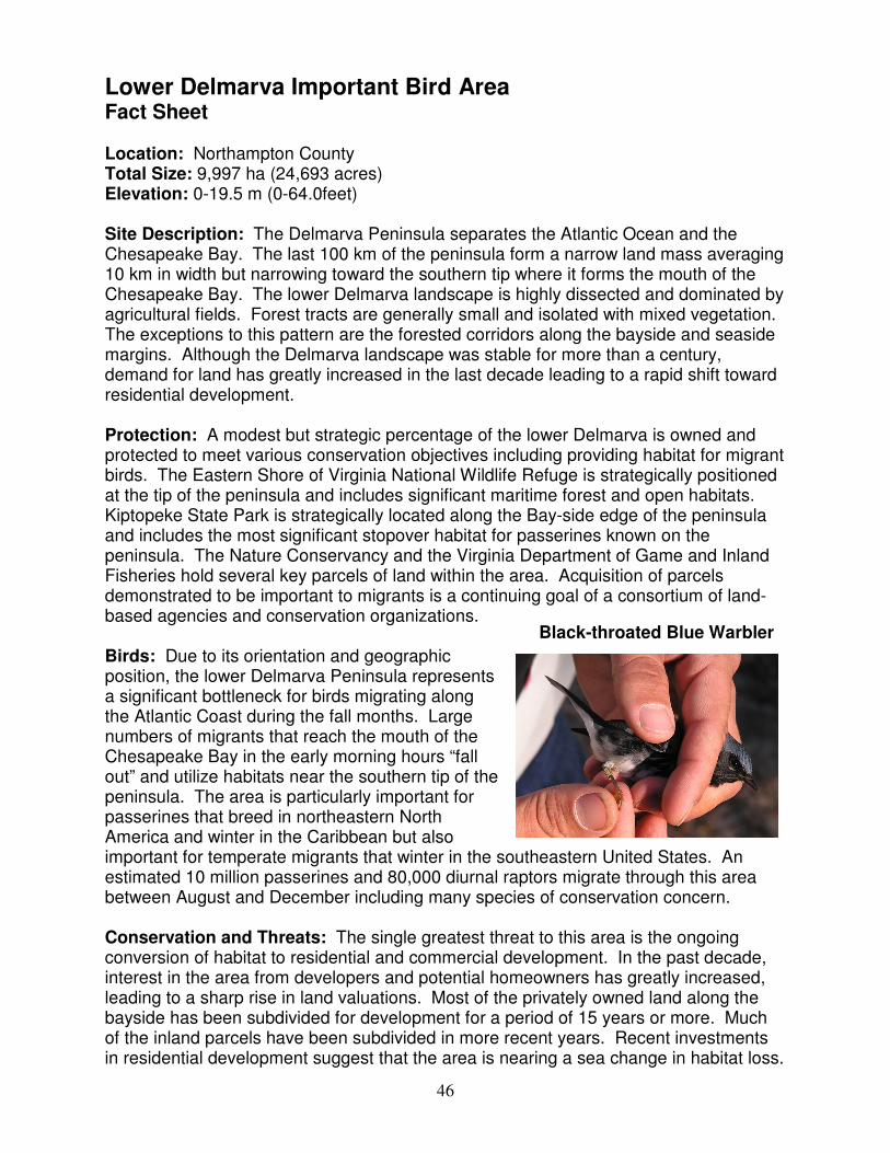
46
Lower Delmarva Important Bird Area Fact Sheet Location: Northampton County Total Size: 9,997 ha (24,693 acres) Elevation: 0-19.5 m (0-64.0feet) Site Description: The Delmarva Peninsula separates the Atlantic Ocean and the Chesapeake Bay. The last 100 km of the peninsula form a narrow land mass averaging 10 km in width but narrowing toward the southern tip where it forms the mouth of the Chesapeake Bay. The lower Delmarva landscape is highly dissected and dominated by agricultural fields. Forest tracts are generally small and isolated with mixed vegetation. The exceptions to this pattern are the forested corridors along the bayside and seaside margins. Although the Delmarva landscape was stable for more than a century, demand for land has greatly increased in the last decade leading to a rapid shift toward residential development. Protection: A modest but strategic percentage of the lower Delmarva is owned and protected to meet various conservation objectives including providing habitat for migrant birds. The Eastern Shore of Virginia National Wildlife Refuge is strategically positioned at the tip of the peninsula and includes significant maritime forest and open habitats. Kiptopeke State Park is strategically located along the Bay-side edge of the peninsula and includes the most significant stopover habitat for passerines known on the peninsula. The Nature Conservancy and the Virginia Department of Game and Inland Fisheries hold several key parcels of land within the area. Acquisition of parcels demonstrated to be important to migrants is a continuing goal of a consortium of land-based agencies and conservation organizations. Birds: Due to its orientation and geographic position, the lower Delmarva Peninsula represents a significant bottleneck for birds migrating along the Atlantic Coast during the fall months. Large numbers of migrants that reach the mouth of the Chesapeake Bay in the early morning hours “fall out” and utilize habitats near the southern tip of the peninsula. The area is particularly important for passerines that breed in northeastern North America and winter in the Caribbean but also important for temperate migrants that winter in the southeastern United States. An estimated 10 million passerines and 80,000 diurnal raptors migrate through this area between August and December including many species of conservation concern. Conservation and Threats: The single greatest threat to this area is the ongoing conversion of habitat to residential and commercial development. In the past decade, interest in the area from developers and potential homeowners has greatly increased, leading to a sharp rise in land valuations. Most of the privately owned land along the bayside has been subdivided for development for a period of 15 years or more. Much of the inland parcels have been subdivided in more recent years. Recent investments in residential development suggest that the area is nearing a sea change in habitat loss.
Black-throated Blue Warbler
47
Other significant threats include the various factors (deer overpopulation, clearing for land sale or development, overstocked pine plantations that lead to canopy closure) that contribute to understory loss. Several research projects over the past 20 years have focused on the distribution and habitat needs of migrants within this area. Current conservation efforts are focused on acquisition of strategic parcels and subsequent habitat improvement.

48
Important Bird Areas of Virginia IBA Nomination Form
The Important Bird Area (IBA) program is an international effort to identify, conserve,
and monitor a network of sites that provide essential habitat for bird populations. BirdLife
International began the IBA program in Europe in 1985. Since that time, BirdLife
partners in more than 100 countries have joined together to build the global IBA network.
Audubon, the BirdLife Partner in the U.S. has been working since 1995 to identify and
conserve hundreds of IBAs all across the United States.
For more information, visit: http://www.audubon.org/bird/iba/index.html
Or contact Aimee Weldon, the Virginia IBA Coordinator
P.O. Box 1089, Ashland, VA 23005 [email protected] 804-370-3528
Additional copies of the Nomination Form may be downloaded from www.virginia-iba.org
Thank you for your interest in the Important Bird Areas Program. Please tell us about the areas
that you think may meet the criteria by completing as much of this form as possible. Detailed
instructions for fields requiring clarification may be found in the INSTRUCTIONS FOR
COMPLETION OF IBA NOMINATION FORM. It is important that the data and information
about the sites are recorded in a standard format, so that they may be accurately evaluated.
I. Nominator Information
YOUR NAME: Bryan D. Watts PHONE: (757) 221-2247
AFFILIATION(if any) Center for Conservation Biology
College of William and Mary
EMAIL: [email protected]
ADDRESS: PO Box 8795
ZIP CITY, STATE, Williamsburg, VA 23187-8795 DATE: 3/18/06
II. Site Details
SITE NAME: Lower Delmarva
CITY,TOWN,COUNTY: Northampton County AREA:
9,997 (circle one) acres, sq. miles., hectares
ELEVATION: Minimum 0 (circle one) feet, meters ELEVATION: Maximum 19.5 feet,
meters
COORDINATES (at site center) Latitude 37° 15´ 35" Longitude: -75° 58´ 50"
Ownership: (Circle One) federal, state, private, international waters, communal, religious group, mixed, other
Ownership Details: (List owners. If “other” ownership, please describe. If the property is privately owned,
please provide contact information and specify if owner is aware of nomination)
United States Fish and Wildlife Service
The Nature Conservancy
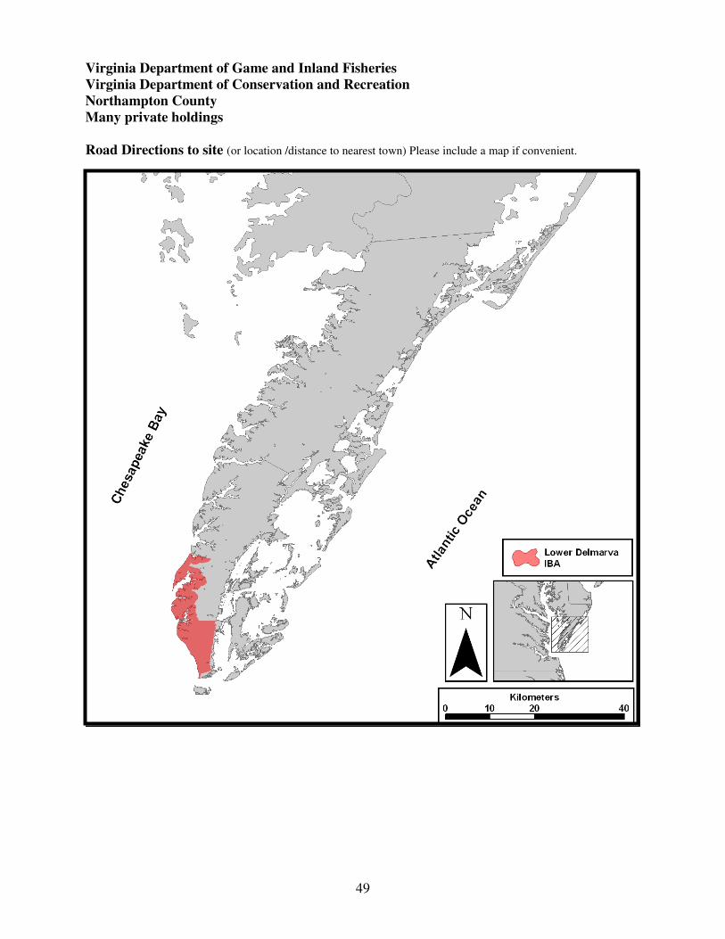
49
Virginia Department of Game and Inland Fisheries
Virginia Department of Conservation and Recreation
Northampton County
Many private holdings
Road Directions to site (or location /distance to nearest town) Please include a map if convenient.

50
Sit
e N
am
e:
Lo
wer
Del
mar
va
III
A. S
pec
ies
Lis
t an
d P
op
ula
tion
Data
L
ist
the
spec
ies
of
signif
ican
ce. P
rovid
e al
l oth
er i
nfo
rmat
ion a
t your
dis
po
sal
(note
: T
yp
es o
f B
irds
Counte
d i
s re
quir
ed).
Eac
h r
ecord
should
repre
sent
a co
unt
at t
he
site
in a
giv
en y
ear.
P
lease
use
th
e fo
llow
ing c
od
es w
hen
com
ple
tin
g t
his
ch
art
.
1.
Rel
ati
ve
Ab
un
da
nce
: A
bund
ant
= A
, C
om
mo
n =
C,
Fre
quen
t =
F,
Unco
mm
on =
U,
Rar
e =
R,
No
t av
aila
ble
= N
A
2.
Co
un
t:
Fo
r al
l sp
ecie
s, e
nte
r ei
ther
Den
sity
(#
per
unit
of
area
), p
leas
e sp
ecif
y h
a, a
cres
, sq
. m
i.
or
Ma
x #
.
Ma
x #
is
the
hig
hest
# o
bse
rved
on o
ne
vis
it i
n a
giv
en
sea
son.
To
tal
seas
on c
ou
nts
may b
e en
tere
d f
or
mig
rati
ng r
apto
rs o
nly
.
3.
Ty
pes
of
Bir
ds
Co
un
ted
: I
nd
ivid
uals
= I
, B
reed
ing P
airs
= B
, A
dult
s o
nly
= A
, M
ales
only
= M
, F
em
ales
only
= F
, N
ests
= N
4.
Rel
iab
ilit
y/D
ata
qu
ali
ty:
Go
od
= G
, M
ediu
m =
M, P
oor
= P
, U
nkno
wn
= U
n
5.
So
urc
e:
Ente
r th
e nu
mb
er o
f th
e so
urc
e in
this
bo
x,
and
lis
t co
rres
po
nd
ing d
etai
ls o
f th
e so
urc
es i
n S
ourc
e D
etai
ls (
IIIB
) se
ctio
n.
So
urc
es m
ay i
ncl
ud
e p
ub
lish
ed
rep
ort
s, s
urv
eys,
per
sonal
ob
serv
atio
ns
or
fiel
d n
ote
s.
( )
valu
es r
epre
sen
t p
op
ula
tion
th
resh
old
s p
er t
he
Vir
gin
ia I
BA
in
stru
ctio
ns.
2C
ou
nts
All
Gro
up
s M
igra
tin
g R
apto
rs O
nly
S
pec
ies
Nam
e
Sea
son
Mo
nth
/Day
of
Ob
serv
atio
n
Yea
r o
f
Ob
serv
atio
n
1R
elat
ive
Ab
un
dan
ce
D
ensi
ty
o
r
M
ax
# /
___
are
a
#
/ v
isit
T
ota
l S
easo
n C
ou
nt
3T
yp
es
of
Bir
ds
Co
unte
d
4R
elia
bil
ity
/Dat
a Q
ual
ity
5S
ou
rce
Bal
d E
agle
S
um
mer
2005
6a(3
0)
B
G
1
Nort
her
n H
arri
er
Sum
mer
1996
1b(?
)
B
G
2
Bar
n O
wl
Sum
mer
1990
3c (5
)
B
M
3
Am
eric
an W
oodco
ck
Win
ter
1993
570
d(5
00)
I
M
4
Brn
-hea
ded
Nuth
atch
S
um
mer
Ue
(
40)
Nort
her
n B
obw
hit
e S
um
mer
Cf
(
300)
5
Chuck
-wil
l’s-
wid
ow
S
um
mer
Ug
(
50)
Wood T
hru
sh
Sum
mer
Ch
(
1000)
Pra
irie
War
ble
r S
um
mer
Ci
(
500)
Eas
tern
Mea
dow
lark
S
um
mer
Cj
(
200)
5
Gra
sshopper
Spar
row
S
um
mer
Ck
(
200)
5
Fie
ld S
par
row
S
um
mer
Cl
(
200)
5
Bic
knel
l’s
Thru
sh
Fal
l
Rm
(?)
6
Mig
rant
Pas
seri
nes
F
all
1992-9
3
An
10 m
illi
on
M
7, 8

51
Mig
rant
Rap
tors
F
all
1995-2
005
Co
20-8
0,0
00
M
9, 10
aA
rea
is n
ot
signif
ican
t fo
r bre
edin
g p
opula
tion, re
pre
senti
ng l
ess
than
2%
of
the
stat
e popula
tion. T
his
are
a w
ill
nev
er r
each
the
IBA
th
resh
old
. bA
sin
gle
bre
edin
g p
air
has
bee
n d
ocu
men
ted w
ith
in t
he
area
, re
pre
senti
ng 4
% o
f th
e know
n C
oas
tal
Pla
in b
reed
ing p
opula
tion.
c Thre
e bre
edin
g p
airs
wer
e know
n f
or
the
stud
y a
rea
in t
he
earl
y 1
990s.
T
he
area
has
the
pote
nti
al t
o s
upport
more
than
5 p
airs
but
ther
e has
bee
n n
o r
ecen
t w
ork
or
man
agem
ent.
dT
he
low
er D
elm
arv
a is
an i
mport
ant
win
ter
trap
for
this
spec
ies.
O
ver
-win
teri
ng n
um
ber
s se
em t
o v
ary w
idel
y. W
inte
r tr
anse
ct s
urv
eys
wit
hin
the
Eas
tern
Shore
of
Vir
gin
ia N
WR
hav
e re
cord
ed n
um
ber
s of
>200 s
ugges
tin
g t
hat
the
thre
shold
is
likel
y e
xce
eded
thro
ughout
the
enti
re a
rea
duri
ng s
om
e yea
rs. A
hig
h c
ount
of
57
0 w
as r
ecord
ed d
uri
ng t
he
Cap
e C
har
les
Chri
stm
as B
ird C
ount
in 1
993.
e This
spec
ies
is a
fai
rly c
om
mon r
esid
ent
par
ticu
larl
y w
ithin
the
mar
itim
e p
ine
fore
sts
that
lin
e th
e m
ainla
nd/m
arsh
ed
ge
(Wat
ts, per
s. O
bs.
).
Ther
e h
ave
bee
n n
o s
yst
emat
ic s
urv
eys
wit
hin
the
area
. H
ow
ever
, bas
ed o
n d
ensi
ties
wit
hin
vis
ited
are
as a
nd t
he
exte
nsi
ve
hab
itat
, it
is
likel
y
that
the
popula
tion i
s se
ver
al t
imes
the
40-p
air
thre
shold
. f T
he
Del
mar
va
Pen
insu
la r
epre
sents
a s
tron
ghold
for
this
spec
ies
in c
oas
tal
Vir
gin
ia. N
o s
yst
emat
ic s
urv
eys
of
this
spec
ies
hav
e bee
n
conduct
ed t
hro
ughout
the
area
. H
ow
ever
, bas
ed o
n d
ensi
ties
wit
hin
sel
ecte
d s
urv
ey a
reas
, th
e popula
tion l
ikel
y e
xce
eds
the
list
ed t
hre
shold
. gT
he
mar
itim
e pin
e fo
rest
s th
at l
ine
the
Del
mar
va
Pen
insu
la a
nd C
hes
apea
ke
Bay s
uppo
rt s
om
e of
the
hig
hes
t bre
edin
g d
ensi
ties
of
this
spec
ies
thro
ughout
its
ran
ge.
N
o s
yst
emat
ic s
urv
ey o
f th
is s
pec
ies
has
bee
n c
ondu
cted
wit
hin
the
area
. H
ow
ever
, bas
ed o
n d
ensi
ties
wit
hin
sel
ecte
d
surv
ey a
reas
and t
he
exte
nsi
ve
hab
itat
support
ed, th
e popula
tion l
ikel
y e
xce
eds
the
list
ed t
hre
shold
. hT
his
spec
ies
occ
urs
thro
ughout
the
mix
ed f
ore
st p
atch
es w
ithin
the
area
. N
o s
yst
emat
ic s
urv
ey o
f th
is s
pec
ies
has
bee
n c
ond
uct
ed w
ithin
the
area
. H
ow
ever
, th
e fo
rest
s of
the
low
er D
elm
arva
are
not
of
the
hig
hes
t qual
ity f
or
this
spec
ies
and t
he
popula
tion w
ithin
the
area
do
es n
ot
mee
t th
e th
resh
old
. i T
his
spec
ies
is c
om
mon w
her
e su
itab
le h
abit
at e
xis
ts. N
o s
yst
emat
ic s
urv
ey o
f th
is s
pec
ies
has
bee
n c
onduct
ed w
ithin
the
area
. I
t is
not
clea
r
whet
her
or
not
this
are
a m
eets
the
popula
tion t
hre
shold
for
this
spec
ies.
C
om
par
ed t
o o
ther
loca
tions
wit
hin
the
Coas
tal
Pla
in, th
is a
rea
is n
ot
par
ticu
larl
y i
mport
ant.
j T
his
spec
ies
is c
om
mon w
her
ever
fal
low
fie
lds
are
pre
sent.
N
o s
yst
emat
ic s
urv
eys
of
this
spec
ies
hav
e bee
n c
onduct
ed t
hro
ughout
the
area
.
How
ever
, bas
ed o
n d
ensi
ties
wit
hin
sel
ecte
d s
urv
ey a
reas
, th
e popula
tion l
ikel
y e
xce
eds
the
list
ed t
hre
shold
kT
he
Del
mar
va
Pen
insu
la r
epre
sents
a s
tron
ghold
for
this
spec
ies
thro
ugho
ut
the
nort
hea
st. N
o s
yst
emat
ic s
urv
eys
of
this
sp
ecie
s hav
e bee
n
conduct
ed t
hro
ughout
the
area
. H
ow
ever
, bas
ed o
n d
ensi
ties
wit
hin
sel
ecte
d s
urv
ey a
reas
and t
he
curr
ent
avai
labil
ity o
f hab
itat
, th
e popula
tion
exce
eds
the
list
ed t
hre
shold
. l T
his
spec
ies
is c
om
mon w
her
e su
itab
le h
abit
at e
xis
ts. N
o s
yst
emat
ic s
urv
ey o
f th
is s
pec
ies
has
bee
n c
onduct
ed w
ithin
the
area
. I
t is
not
clea
r
whet
her
or
not
this
are
a m
eets
the
popula
tion t
hre
shold
for
this
spec
ies.
C
om
par
ed t
o o
ther
loca
tions
wit
hin
the
Coas
tal
Pla
in, th
is a
rea
is n
ot
par
ticu
larl
y i
mport
ant.
m
Evid
ence
fro
m t
he
Kip
topek
e B
andin
g S
tati
on a
nd o
ther
sta
tions
in e
aste
rn N
ort
h A
mer
ica
sugges
t th
at v
irtu
ally
100%
of
the
worl
d’s
popula
tion o
f th
is s
pec
ies
mig
rate
s th
rou
gh c
oas
tal
Vir
gin
ia w
ith a
port
ion s
toppin
g o
ver
on t
he
low
er D
elm
arv
a. C
aptu
res
hav
e dec
lined
fro
m

52
sever
al d
oze
n i
n t
he
late
1960s
to a
ppro
xim
atel
y 1
/yr
curr
entl
y. T
he
rela
tiv
e si
gnif
ican
ce o
f th
is s
topover
are
a w
ithin
thei
r an
nual
cycl
e is
not
know
n.
nT
he
low
er D
elm
arv
a P
enin
sula
is
a geo
gra
phic
tra
p f
or
pas
seri
nes
mig
rati
ng a
lon
g t
he
Atl
anti
c C
oas
t in
the
fall
month
s. A
stu
dy c
ondu
cted
in
the
earl
y 1
990s
docu
men
ted a
den
sity
gra
die
nt
in s
topover
den
sity
wit
h t
he
hig
hes
t den
siti
es o
ccurr
ing n
ear
the
tip a
nd a
long t
he
baysi
de
mar
gin
. T
hes
e ar
eas
support
lar
ge
num
ber
s o
f neo
tropic
al a
nd t
emper
ate
mig
rants
.
oD
ue
to i
ts g
eogra
phic
po
siti
on a
nd s
hap
e, t
he
low
er D
elm
arva
Pen
insu
la h
as a
funnel
ing e
ffec
t on r
apto
rs (
both
diu
rnal
and n
oct
urn
al)
mig
rati
ng a
lon
g t
he
Atl
anti
c C
oas
t.
Lar
ge
num
ber
s of
bir
ds
of
sev
eral
spec
ies
both
mig
rate
thro
ugh t
he
area
and s
topover
to p
rey o
n a
vai
lable
bir
ds
and s
mal
l m
amm
als.

53
Site Name: Lower Delmarva
III B. Source Details
Detail the sources of data noted in the “Species List and Population Data” (III A) Section.
If additional space is needed, you may attach copies of this form to the nomination.
1. Watts, B. D. and M. A. Byrd 2005. Virginia bald eagle nest and productivity survey: Year
2005 report. Center for Conservation Biology Technical Report Series, CCBTR-05-05. College
of William and Mary, Williamsburg, VA. 27 pp.
2. Watts, B. D. and S. J. Rottenborn. 2001. Breeding status of Northern Harriers in coastal
Virginia. The Raven 72:153-157.
3. Watts, B. D. and D. M. Whalen. 2004. An evaluation of nest box use by Common Barn Owls
in Virginia. The Raven 75:71-77.
4. Kain, T. 1995. Virginia Christmas Bird Counts--1993-94 Season. Raven, 66(1)45-80.
5. Watts, B. D., M. D. Wilson, and D. S. Bradshaw. 1997. Habitat requirements of early
successional bird communities: Management implications for mid-Atlantic region. Center for
Conservation Biology Technical Report Series, CCBTR-97-03. College of William and Mary,
Williamsburg, VA. 62pp.
6. Wilson, M. D. and B. D. Watts. 1997. Autumn migration of Gray-cheeked and Bicknell's
Thrushes at Kiptopeke, Virginia, USA. Journal of Field Ornithology 68:519-525.
7. Watts, B. D. and S. E. Mabey. 1993. Spatio-temporal patterns of landbird migration on the
lower Delmarva Peninsula. Center for Conservation Biology Technical Report Series, CCBTR-
93-01. College of William and Mary, Williamsburg, VA. 57pp.
8. Watts, B. D. and S. E. Mabey. 1994. Migratory landbirds of the lower Delmarva: habitat
selection and geographic distribution. Center for Conservation Biology Technical Report Series,
CCBTR-94-05. College of William and Mary, Williamsburg, 101pp.
9. CVWO. 2002. Field Research Report 1995-2002. Coastal Virginia Wildlife Observatory,
Eastville.
10. Whalen, D. M. and B. D. Watts. 2002. Annual migration density and stopover patterns of
Northern Saw-whet Owls (Aegolius acadicus). Auk 119:1161-2002.

54
Site Name: Lower Delmarva
IV. IBA Criteria
Proposed State Level Criteria – Mark all that apply
See Instruction IV for Explanations of Criteria.
Code State Definition Mark all
criteria that
apply
D 1.
D 3.
D 4.
Endangered, threatened, or vulnerable species: The site sustains a
breeding or non-breeding population of one or more bird species, sub-
species, or isolated populations that is/are endangered, threatened or
vulnerable to extirpation.
The site contains a significant suite of species associated with a habitat
type that is representative, rare, or threatened in Virginia.
The site contains a significant concentration of one or more species
during the breeding season, winter, or during migration.
Yes
No
Yes
V. Habitat Details
See Instruction V for List of Habitats at both levels below.
Major vegetation community types Predominant plant species Cover %
1.
Mixed forest
3,000 ha
2.
Fallow farmland
170 ha
3.
Active agriculture
5,600 ha
4.

55
Site Name: Lower Delmarva
VI. Land Use See Instruction VI for description of Land Uses. Mark each land use at the site, circle its predominance,
and (if known) provide an estimate of the percent cover at the site currently devoted to the land use. You
may enter brief notes to clarify some land uses. Detailed explanations of land uses should be reported in
Text Summary, section IX. Check
Here Land Use Predominance Cover % Notes
X Agriculture 1. Row crops, small grains Major Minor Unknown
X Agriculture 2. Grasslands (pasture, hay) Major Minor Unknown
X Fisheries/aquaculture Major Minor Unknown
X Forestry Major Minor Unknown
X Hunting Major Minor Unknown
Military Major Minor Unknown
X Nature Conservation / research Major Minor Unknown
Not utilized Major Minor Unknown
Other Major Minor Unknown
X Tourism / recreation Major Minor Unknown
Unknown Major Minor Unknown
X Urban / industrial / transport Major Minor Unknown
Water management Major Minor Unknown
VII. Threats See Instruction VII for description of Threat Codes. Indicate all threats and the relative level of the
threat by entering (L) Low, (M) Medium, (H) high, (U) Unknown in front of all that apply. You may
enter notes to clarify some threats. However, detailed explanations of threats should be reported in Text
Summary, section IX. Enter
L,M,H,U Threat Notes
L Abandonment/land management reduction
M Agricultural expansion/intensification Conversion from row crop to plasticulture
Aquaculture/fisheries
L Burning of vegetation
Dam/dyke/barrage construction/operations
L Disturbance to birds
L Draining wetlands
Dredging/canal building (irrigation)
L Filling wetlands
H Forest grazing (by native or domestic herbivores) Overpopulated deer impacts to understory
L Groundwater extraction
M Industrialization/urbanization Conversion of forests to residential
L Infrastructure (roads, power lines, cell towers, etc.)
L Intensified forest management (please elaborate)
L Isolation/fragmentation
Mineral/oil/peat extraction
L Natural events
H Nonnative (exotic) animal/plant introduction High density of exotic plants
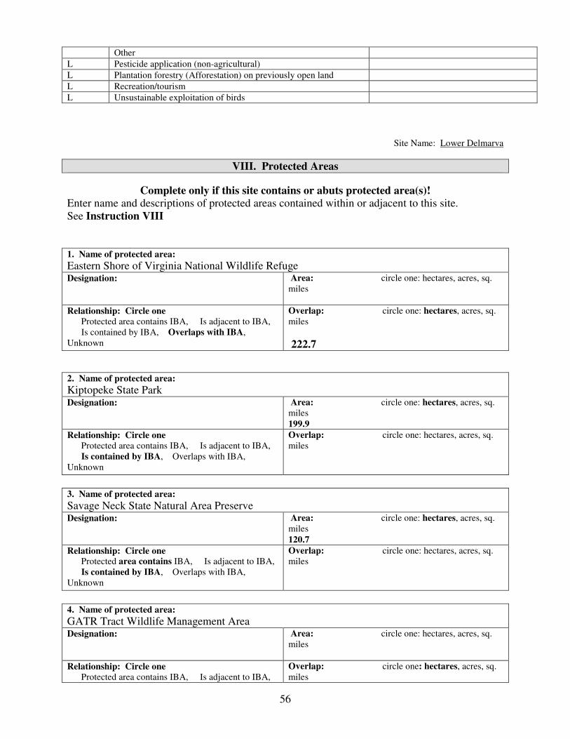
56
Other
L Pesticide application (non-agricultural)
L Plantation forestry (Afforestation) on previously open land
L Recreation/tourism
L Unsustainable exploitation of birds
Site Name: Lower Delmarva
VIII. Protected Areas
Complete only if this site contains or abuts protected area(s)! Enter name and descriptions of protected areas contained within or adjacent to this site.
See Instruction VIII
1. Name of protected area:
Eastern Shore of Virginia National Wildlife Refuge Designation: Area: circle one: hectares, acres, sq.
miles
Relationship: Circle one Protected area contains IBA, Is adjacent to IBA,
Is contained by IBA, Overlaps with IBA,
Unknown
Overlap: circle one: hectares, acres, sq.
miles
222.7
2. Name of protected area:
Kiptopeke State Park Designation: Area: circle one: hectares, acres, sq.
miles
199.9
Relationship: Circle one Protected area contains IBA, Is adjacent to IBA,
Is contained by IBA, Overlaps with IBA,
Unknown
Overlap: circle one: hectares, acres, sq.
miles
3. Name of protected area:
Savage Neck State Natural Area Preserve Designation: Area: circle one: hectares, acres, sq.
miles
120.7
Relationship: Circle one Protected area contains IBA, Is adjacent to IBA,
Is contained by IBA, Overlaps with IBA,
Unknown
Overlap: circle one: hectares, acres, sq.
miles
4. Name of protected area:
GATR Tract Wildlife Management Area Designation: Area: circle one: hectares, acres, sq.
miles
Relationship: Circle one Protected area contains IBA, Is adjacent to IBA,
Overlap: circle one: hectares, acres, sq.
miles

57
Is contained by IBA, Overlaps with IBA,
Unknown
64.2
5. Name of protected area:
Magothy Bay Preserve Designation: Area: circle one: hectares, acres, sq.
miles
23.0
Relationship: Circle one Protected area contains IBA, Is adjacent to IBA,
Is contained by IBA, Overlaps with IBA,
Unknown
Overlap: circle one: hectares, acres, sq.
miles
6. Name of protected area: Wm. B. Trower Bayshore State Natural Area Preserve Designation: Area: circle one: hectares, acres, sq.
miles
13.9
Relationship: Circle one Protected area contains IBA, Is adjacent to IBA,
Is contained by IBA, Overlaps with IBA,
Unknown
Overlap: circle one: hectares, acres, sq.
miles
7. Name of protected area:
Cape Charles Coastal Habitat State Natural Area Preserve Designation: Area: circle one: hectares, acres, sq.
miles
11.0 Relationship: Circle one Protected area contains IBA, Is adjacent to IBA,
Is contained by IBA, Overlaps with IBA,
Unknown
Overlap: circle one: hectares, acres, sq.
miles
IX. Text Summary
Use the following space for additional descriptions of site details.
General Site Description: The Delmarva Peninsula separates the Atlantic Ocean and the
Chesapeake Bay. The last 100 km of the peninsula form a narrow land mass averaging 10 km in
width. The lower Delmarva landscape is highly dissected and dominated by agricultural fields.
Forest tracts are generally small and isolated with mixed vegetation. The exceptions to this
pattern are the forested corridors along the bayside and seaside margins. Canopy trees are
dominated by loblolly pine (Pinus taeda), Virginia pine (P. virginiana), red maple (Acer
rubrum), and various oaks (Quercus spp.), and hickories (Carya spp.). Understory trees are
dominated by flowering dogwood (Cornus florida), black cherry (Prunus serotina), and
American holly (Ilex opaca). Although the Delmarva landscape was stable for more than a
century, demand for land has greatly increased in the last decade leading to a rapid shift
toward residential development.
58
General Ornithological Information: The spectacle of bird migration during the fall months
on the lower Delmarva has been observed by residents for generations and has been of interest to
the ornithological community since at least the late 1800s. Consistent efforts to document
various aspects of migration through the area began with the establishment of the Kiptopeke
Banding Station in 1963. A very large number of research and monitoring projects have been
conducted since that time. Of particular note is the 42-year passerine banding data set that
includes records of more than 300,000 birds, the nearly 30-year hawkwatch that includes more
than 650,000 records, and the raptor trapping banding data set that includes more than 25,000
records. Benchmark studies that have examined geographic distribution and habitat use have
been conducted in 1992-1993, and 2001-2005. The recent use of NPOL radar in conjunction
with ground surveys is focused on further highlighting important stopover areas within the area.
Research / conservation projects: A large number of research and conservation projects have
been conducted within this area over the past few decades involving a large number of federal
and state agencies, as well, as NGOs and academic institutions.
Habitat / Land Use: The system is comprised primarily of upland agricultural fields and
patches of mixed forest.
Other Flora / Fauna:
Protected Areas: A modest percentage of the system is owned and protected to meet various
conservation objectives including providing habitat for migrants. Holders include the U.S. Fish
and Wildlife Service, The Nature Conservancy, the Virginia Department of Game and Inland
Fisheries, and the Virginia Department of Conservation and Recreation, Division of Natural
Heritage. Acquisition of parcels demonstrated to be important to migrants is a continuing goal of
a consortium of land-based agencies and conservation organizations.
Threats: The single greatest threat to this area is the ongoing conversion of habitat to residential
and commercial development. In the past decade, interest in the area from developers and
potential homeowners has greatly increased, leading to an incredible rise in land valuations.
Further increases may price the conservation community out of the market. Most of the privately
owned land along the bayside has been subdivided for development for a period of 15 years or
more. Much of the inland parcels have been subdivided in more recent years. Recent
investments in residential developments suggest that the area is nearing a sea change in habitat
loss. Other significant threats include the various factors (deer overpopulation, clearing for land
sale or development, overstocked pine plantations that lead to canopy closure) that contribute to
understory loss.

59
Back Bay Important Bird Area Fact Sheet Location: Virginia Beach Total Size: 16,079 ha (39,715 acres) Elevation: 0-15.7 m (0-51.9feet) Site Description: Back Bay is a coastal bay that forms the northern extent and headwaters of Currituck Sound. The salinity conditions within this system have led to the formation of extensive big cordgrass marshes within the bay, many of which are island patches isolated from the mainland. The active beach and dunes on the ocean fringe represent the upper end of the barrier network forming the Outer Banks. Landward of the dunes is a system of impoundments and a maritime forest dominated by loblolly pines and wax myrtle. Protection: A considerable portion of this system is owned by government agencies and is operated under a specific mandate for wildlife management. Back Bay National Wildlife Refuge contains active beach, dunes, maritime forest, limited open uplands, and extensive areas of big cordgrass marsh. False Cape State Park includes large tracks of maritime forest, as well as, beach and dune habitats. Princess Anne Wildlife Management Area supports large tracks of big cordgrass marsh along the western boundary of the important bird area. The boundary of Mackay Island National Wildlife Refuge extends into the area and contains big cordgrass marsh and limited upland habitats. Birds: Back Bay supports the full suite of bird species associated with big cordgrass habitat during both the summer and winter periods. The area likely supports the largest population of King Rails in Virginia. Due to its geographic position and habitat, the area represents the normal, northern range limit for Sedge Wren, American Bittern, and Yellow Rail during winter. The outer beaches support significant numbers of migrant shorebirds dominated by Sanderlings but including Red Knots. Historically, the area has been a focal area for waterfowl during winter. A systematic effort is needed to better quantify the use of the system by overwintering species such as the Yellow Rail and migrant species such as the Least Bittern. Conservation and Threats: Primary threats to bird population include 1) loss of habitat to the invasion by common reed, 2) loss of habitat to sea-level rise, and 3) system perturbations related to major storm events. The aggressive invasive plant common reed is spreading rapidly throughout this system particularly along the western shoreline where it has invaded along artificial canals. Big cordgrass islands are particularly vulnerable to rising sea levels. Continued rises in sea level may lead to a shift in species composition or ultimately to the loss of some islands altogether. Monitoring programs have been ongoing for wintering waterfowl, migrant shorebirds, marsh birds, colonial waterbirds, Bald Eagles, and Osprey. The U.S. Fish and Wildlife
King Rail

60
Service performs regular conservation activities including impoundment management and marsh burning.
61
Important Bird Areas of Virginia IBA Nomination Form
The Important Bird Area (IBA) program is an international effort to identify, conserve,
and monitor a network of sites that provide essential habitat for bird populations. BirdLife
International began the IBA program in Europe in 1985. Since that time, BirdLife
partners in more than 100 countries have joined together to build the global IBA network.
Audubon, the BirdLife Partner in the U.S. has been working since 1995 to identify and
conserve hundreds of IBAs all across the United States.
For more information, visit: http://www.audubon.org/bird/iba/index.html
Or contact Aimee Weldon, the Virginia IBA Coordinator
P.O. Box 1089, Ashland, VA 23005 [email protected] 804-370-3528
Additional copies of the Nomination Form may be downloaded from www.virginia-iba.org
Thank you for your interest in the Important Bird Areas Program. Please tell us about the areas
that you think may meet the criteria by completing as much of this form as possible. Detailed
instructions for fields requiring clarification may be found in the INSTRUCTIONS FOR
COMPLETION OF IBA NOMINATION FORM. It is important that the data and information
about the sites are recorded in a standard format, so that they may be accurately evaluated.
I. Nominator Information
YOUR NAME: Bryan D. Watts PHONE: (757) 221-2247
AFFILIATION(if any) Center for Conservation Biology
College of William and Mary
EMAIL: [email protected]
ADDRESS: PO Box 8795
ZIP CITY, STATE, Williamsburg, VA 23187-8795 DATE: 3/18/06
II. Site Details
SITE NAME: Back Bay
CITY,TOWN,COUNTY: Virginia Beach AREA:
16,079 (circle one) acres, sq. miles., hectares
ELEVATION: Minimum 0 (circle one) feet, meters ELEVATION: Maximum 15.7 feet, meters
COORDINATES (at site center) Latitude 36° 37´ 34” Longitude: -75 ° 56´ 29"
Ownership: (Circle One) federal, state, private, international waters, communal, religious group, mixed, other
Ownership Details: (List owners. If “other” ownership, please describe. If the property is privately owned,
please provide contact information and specify if owner is aware of nomination)
Virginia Department of Game and Inland Fisheries
Virginia Department of Conservation and Recreation
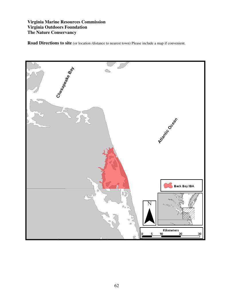
62
Virginia Marine Resources Commission
Virginia Outdoors Foundation
The Nature Conservancy
Road Directions to site (or location /distance to nearest town) Please include a map if convenient.

63
Sit
e N
am
e:
Bac
k B
ay
III
A. S
pec
ies
Lis
t an
d P
op
ula
tion
Data
L
ist
the
spec
ies
of
signif
ican
ce. P
rovid
e al
l oth
er i
nfo
rmat
ion a
t your
dis
po
sal
(note
: T
yp
es o
f B
irds
Counte
d i
s re
quir
ed).
Eac
h r
ecord
should
repre
sent
a co
unt
at t
he
site
in a
giv
en y
ear.
P
lease
use
th
e fo
llow
ing c
od
es w
hen
com
ple
tin
g t
his
ch
art
.
1.
Rel
ati
ve
Ab
un
da
nce
: A
bund
ant
= A
, C
om
mo
n =
C,
Fre
quen
t =
F,
Unco
mm
on =
U,
Rar
e =
R,
No
t av
aila
ble
= N
A
2.
Co
un
t:
Fo
r al
l sp
ecie
s, e
nte
r ei
ther
Den
sity
(#
per
unit
of
area
), p
leas
e sp
ecif
y h
a, a
cres
, sq
. m
i.
or
Ma
x #
.
Ma
x #
is
the
hig
hest
# o
bse
rved
on o
ne
vis
it i
n a
giv
en
sea
son.
To
tal
seas
on c
ou
nts
may b
e en
tere
d f
or
mig
rati
ng r
apto
rs o
nly
.
3.
Ty
pes
of
Bir
ds
Co
un
ted
: I
nd
ivid
uals
= I
, B
reed
ing P
airs
= B
, A
dult
s o
nly
= A
, M
ales
only
= M
, F
em
ales
only
= F
, N
ests
= N
4.
Rel
iab
ilit
y/D
ata
qu
ali
ty:
Go
od
= G
, M
ediu
m =
M, P
oor
= P
, U
nkno
wn
= U
n
5.
So
urc
e:
Ente
r th
e nu
mb
er o
f th
e so
urc
e in
this
bo
x,
and
lis
t co
rres
po
nd
ing d
etai
ls o
f th
e so
urc
es i
n S
ourc
e D
etai
ls (
IIIB
) se
ctio
n.
So
urc
es m
ay i
ncl
ud
e p
ub
lish
ed
rep
ort
s, s
urv
eys,
per
sonal
ob
serv
atio
ns
or
fiel
d n
ote
s.
( )
valu
es r
epre
sen
t p
op
ula
tion
th
resh
old
s p
er t
he
Vir
gin
ia I
BA
in
stru
ctio
ns.
2C
ou
nts
All
Gro
up
s M
igra
tin
g R
apto
rs O
nly
S
pec
ies
Nam
e
Sea
son
Mo
nth
/Day
of
Ob
serv
ati
on
Yea
r o
f
Ob
serv
atio
n
1R
elat
ive
Ab
un
dan
ce
D
ensi
ty
o
r
M
ax
# /
___
are
a
#
/ v
isit
T
ota
l S
easo
n C
ou
nt
3T
yp
es
of
Bir
ds
Co
unte
d
4R
elia
bil
ity
/Dat
a Q
ual
ity
5S
ou
rce
Pip
ing P
lover
H
ist
Rec
a(a
ll)
Nel
son’s
Sh-t
Spar
row
W
inte
r 2001
2b(1
00)
I
P
1
Am
eric
an B
itte
rn
Win
ter
1999
11
c (5)
I
P
2
Bal
d E
agle
S
um
mer
2005
2d(3
0)
B
G
3
Kin
g R
ail
Sum
mer
60
e (30)
B
M
4
Lea
st B
itte
rn
Sum
mer
Uf
(5
0)
Nort
her
n H
arri
er
Win
ter
2000
37
g(?
)
I M
5
Bar
n O
wl
Sum
mer
2000
3h(5
)
B
M
6
Sed
ge
Wre
n
Win
ter
1999
37
i (5)
I
P
2
Yel
low
Rai
l W
inte
r 1999
1j (a
ll)
I
P
2
Red
Knot
Spri
ng
2005
55
k(2
40
)
I G
7
Brn
-hea
ded
Nuth
atch
W
inte
r 2001
59
l (40)
I
P
1
Short
-ear
ed O
wl
Sum
mer
2000
1m
(10)
I
M
8
Chuck
-wil
l’s-
wid
ow
S
um
mer
Cn
(50)
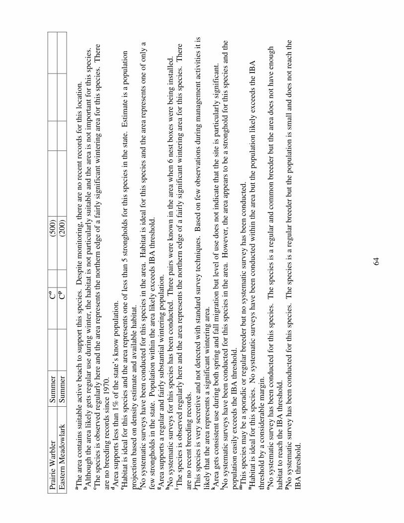
64
Pra
irie
War
ble
r S
um
mer
Co
(5
00)
Eas
tern
Mea
dow
lark
S
um
mer
Cp
(2
00)
aT
he
area
conta
ins
suit
able
act
ive
bea
ch t
o s
upport
this
spec
ies.
D
espit
e m
onit
ori
ng, th
ere
are
no r
ecen
t re
cord
s fo
r th
is l
oca
tion.
bA
lthough t
he
area
lik
ely g
ets
regula
r use
duri
ng w
inte
r, t
he
hab
itat
is
not
par
ticu
larl
y s
uit
able
and t
he
area
is
not
import
ant
for
this
spec
ies.
c T
he
spec
ies
is o
bse
rved
reg
ula
rly h
ere
and t
he
area
rep
rese
nts
the
nort
her
n e
dge
of
a fa
irly
sig
nif
ican
t w
inte
ring a
rea
for
this
spec
ies.
T
her
e
are
no b
reed
ing r
ecord
s si
nce
1970.
dA
rea
suppo
rts
less
than
1%
of
the
stat
e’s
kno
w p
opula
tion.
e Hab
itat
is
idea
l fo
r th
is s
pec
ies
and t
he
area
rep
rese
nts
one
of
less
than
5 s
tronghold
s fo
r th
is s
pec
ies
in t
he
stat
e. E
stim
ate
is a
popula
tion
pro
ject
ion b
ased
on d
ensi
ty e
stim
ate
and a
vai
lable
hab
itat
. f N
o s
yst
emat
ic s
urv
eys
hav
e bee
n c
onduct
ed f
or
this
spec
ies
in t
he
area
. H
abit
at i
s id
eal
for
this
spec
ies
and t
he
area
rep
rese
nts
one
of
only
a
few
str
on
ghold
s in
the
stat
e. P
opula
tion w
ithin
the
area
lik
ely e
xce
eds
IBA
thre
shold
.
gA
rea
support
s a
regula
r an
d f
airl
y s
ubst
anti
al w
inte
ring p
opula
tion.
hN
o s
yst
emat
ic s
urv
eys
for
this
spec
ies
has
bee
n c
onduct
ed. T
hre
e pai
rs w
ere
know
n i
n t
he
area
wh
en 6
nes
t box
es w
ere
bei
ng i
nst
alle
d.
i T
he
spec
ies
is o
bse
rved
reg
ula
rly h
ere
and t
he
area
rep
rese
nts
the
nort
her
n e
dge
of
a fa
irly
sig
nif
ican
t w
inte
ring a
rea
for
this
spec
ies.
T
her
e
are
no r
ecen
t bre
edin
g r
ecord
s.
j This
spec
ies
is v
ery s
ecre
tive
and n
ot
det
ecte
d w
ith s
tandar
d s
urv
ey t
echniq
ues
. B
ased
on f
ew o
bse
rvat
ions
duri
ng m
anag
emen
t ac
tivit
ies
it i
s
likel
y t
hat
the
area
rep
rese
nts
a s
ignif
ican
t w
inte
ring a
rea.
kA
rea
get
s co
nsi
sten
t use
duri
ng b
oth
spri
ng a
nd f
all
mig
rati
on b
ut
level
of
use
does
not
indic
ate
that
the
site
is
par
ticu
larl
y s
ignif
ican
t.
l No s
yst
emat
ic s
urv
eys
hav
e bee
n c
onduct
ed f
or
this
spec
ies
in t
he
area
. H
ow
ever
, th
e ar
ea a
pp
ears
to b
e a
stro
nghold
for
this
spec
ies
and t
he
popula
tion e
asil
y e
xce
eds
the
IBA
thre
shold
. m
This
spec
ies
may b
e a
spora
dic
or
regula
r b
reed
er b
ut
no s
yst
emat
ic s
urv
ey h
as b
een c
onduct
ed.
nH
abit
at i
s id
eal
for
this
spec
ies.
N
o s
yst
emat
ic s
urv
eys
hav
e b
een c
onduct
ed w
ithin
the
area
but
the
popula
tion l
ikel
y e
xce
eds
the
IBA
thre
shold
by a
consi
der
able
mar
gin
. oN
o s
yst
emat
ic s
urv
ey h
as b
een c
onduct
ed f
or
this
spec
ies.
T
he
spec
ies
is a
reg
ula
r an
d c
om
mon b
reed
er b
ut
the
area
does
no
t hav
e en
ou
gh
hab
itat
to r
each
th
e IB
A t
hre
shold
. pN
o s
yst
emat
ic s
urv
ey h
as b
een c
onduct
ed f
or
this
spec
ies.
T
he
spec
ies
is a
reg
ula
r bre
eder
but
the
popula
tion i
s sm
all
and d
oes
not
reac
h t
he
IBA
thre
shold
.

65
Site Name: Back Bay
III B. Source Details
Detail the sources of data noted in the “Species List and Population Data” (III A) Section. If
additional space is needed, you may attach copies of this form to the nomination.
1. Kain, T. 2002. Virginia Christmas Bird Counts: 2001-2002 season. Raven 73:17-54.
2. Kain, T. 2000. Virginia Christmas Bird Counts: 1999-2000 season. Raven 71:71-104.
3. Watts, B. D. and M. A. Byrd 2005. Virginia bald eagle nest and productivity survey: Year 2005
report. Center for Conservation Biology Technical Report Series, CCBTR-05-05. College of William
and Mary, Williamsburg, VA. 27 pp.
4. Watts, B. D. Projection of breeding King Rail population within Back Bay. Unpublished analysis.
5. Kain, T. 2001. Virginia Christmas Bird Counts: 2000-2001 season. Raven 72:17-51.
6. Watts, B. D. 2003. An evaluation of nest box use by Barn Owls and the initiation of a new box
program on coastal marshlands in Virginia. Center for Conservation Biology Technical Report Series,
CCBTR-03-09. College of William and Mary, Williamsburg, VA. 16 pp.
7. USGS ground survey data for Back Bay, NWR and False Cape State Park, unpublished data.
8. Watts, B. D. Observation of bird on 12 July, 2000 on Cedar Island, unpublished observation.
Site Name: Back Bay
IV. IBA Criteria
Proposed State Level Criteria – Mark all that apply
See Instruction IV for Explanations of Criteria.
Code State Definition Mark all
criteria that
apply

66
D 1.
D 3.
D 4.
Endangered, threatened, or vulnerable species: The site sustains a breeding or
non-breeding population of one or more bird species, sub-species, or isolated
populations that is/are endangered, threatened or vulnerable to extirpation.
The site contains a significant suite of species associated with a habitat type
that is representative, rare, or threatened in Virginia.
The site contains a significant concentration of one or more species during the
breeding season, winter, or during migration.
Yes
Yes
No
V. Habitat Details
See Instruction V for List of Habitats at both levels below.
Major vegetation community types Predominant plant species Cover %
Big Cordgrass
1.
Brackish Marsh
2817.6 ha
Loblolly Pine
Wax Myrtle
2.
Maritime Pine Forest
362.1 ha
3.
Active Beach
386.6 ha
4.
Site Name: Back Bay
VI. Land Use See Instruction VI for description of Land Uses. Mark each land use at the site, circle its predominance, and (if
known) provide an estimate of the percent cover at the site currently devoted to the land use. You may enter brief
notes to clarify some land uses. Detailed explanations of land uses should be reported in Text Summary, section IX. Check
Here Land Use Predominance Cover % Notes
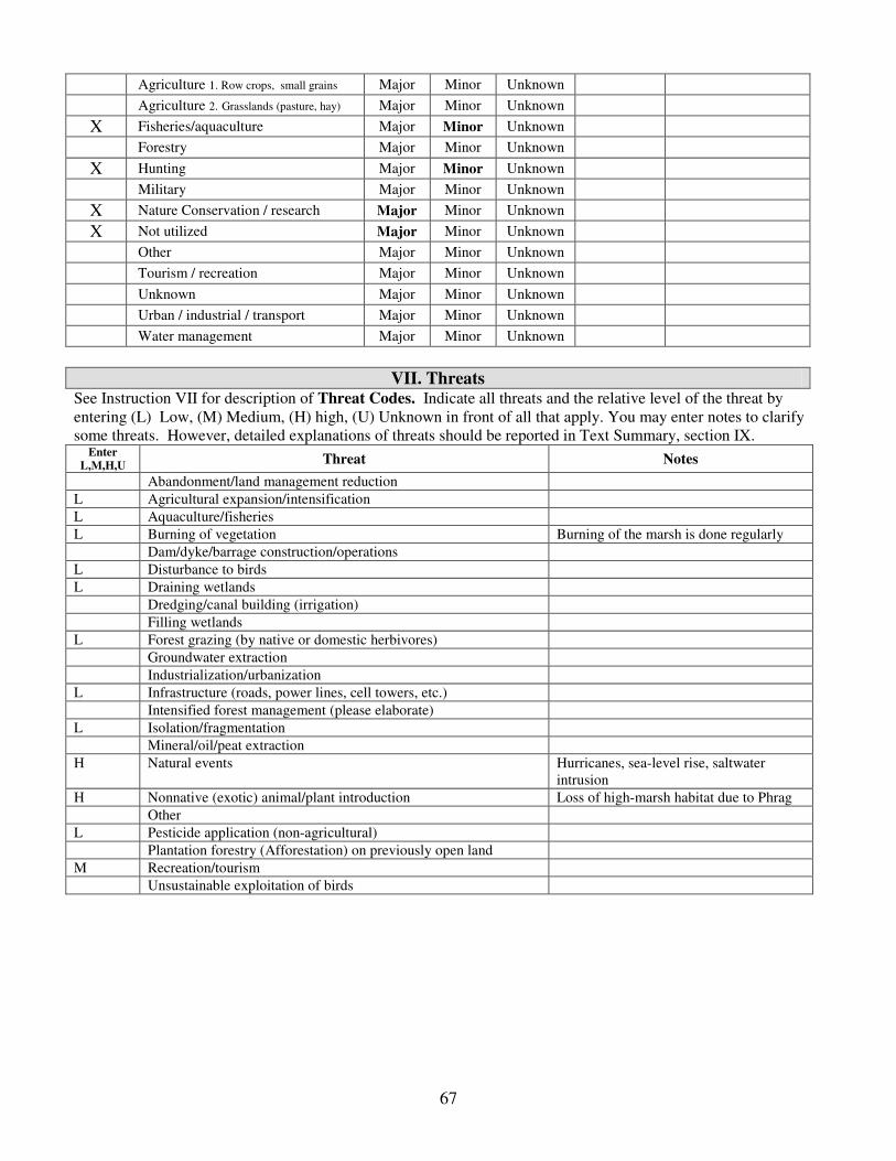
67
Agriculture 1. Row crops, small grains Major Minor Unknown
Agriculture 2. Grasslands (pasture, hay) Major Minor Unknown
X Fisheries/aquaculture Major Minor Unknown
Forestry Major Minor Unknown
X Hunting Major Minor Unknown
Military Major Minor Unknown
X Nature Conservation / research Major Minor Unknown
X Not utilized Major Minor Unknown
Other Major Minor Unknown
Tourism / recreation Major Minor Unknown
Unknown Major Minor Unknown
Urban / industrial / transport Major Minor Unknown
Water management Major Minor Unknown
VII. Threats See Instruction VII for description of Threat Codes. Indicate all threats and the relative level of the threat by
entering (L) Low, (M) Medium, (H) high, (U) Unknown in front of all that apply. You may enter notes to clarify
some threats. However, detailed explanations of threats should be reported in Text Summary, section IX. Enter
L,M,H,U Threat Notes
Abandonment/land management reduction
L Agricultural expansion/intensification
L Aquaculture/fisheries
L Burning of vegetation Burning of the marsh is done regularly
Dam/dyke/barrage construction/operations
L Disturbance to birds
L Draining wetlands
Dredging/canal building (irrigation)
Filling wetlands
L Forest grazing (by native or domestic herbivores)
Groundwater extraction
Industrialization/urbanization
L Infrastructure (roads, power lines, cell towers, etc.)
Intensified forest management (please elaborate)
L Isolation/fragmentation
Mineral/oil/peat extraction
H Natural events Hurricanes, sea-level rise, saltwater
intrusion
H Nonnative (exotic) animal/plant introduction Loss of high-marsh habitat due to Phrag
Other
L Pesticide application (non-agricultural)
Plantation forestry (Afforestation) on previously open land
M Recreation/tourism
Unsustainable exploitation of birds

68
Site Name: Back Bay
VIII. Protected Areas
Complete only if this site contains or abuts protected area(s)! Enter name and descriptions of protected areas contained within or adjacent to this site.
See Instruction VIII
1. Name of protected area:
Back Bay National Wildlife Refuge Designation: Area: circle one: hectares, acres, sq. miles
2540.4 Relationship: Circle one Protected area contains IBA, Is adjacent to IBA,
Is contained by IBA, Overlaps with IBA, Unknown
Overlap: circle one: hectares, acres, sq. miles
2. Name of protected area:
False Cape State Park Designation: Area: circle one: hectares, acres, sq. miles
1567.7 Relationship: Circle one Protected area contains IBA, Is adjacent to IBA,
Is contained by IBA, Overlaps with IBA, Unknown
Overlap: circle one: hectares, acres, sq. miles
3. Name of protected area:
Princess Anne, Wildlife Management Area Designation: Area: circle one: hectares, acres, sq. miles
Relationship: Circle one Protected area contains IBA, Is adjacent to IBA,
Is contained by IBA, Overlaps with IBA, Unknown
Overlap: circle one: hectares, acres, sq. miles
459.2
4. Name of protected area:
Mackey Island National Wildlife Refuge Designation: Area: circle one: hectares, acres, sq. miles
Relationship: Circle one Protected area contains IBA, Is adjacent to IBA,
Is contained by IBA, Overlaps with IBA, Unknown
Overlap: circle one: hectares, acres, sq. miles
286.6
5. Name of protected area:
Little Island Park Designation: Area: circle one: hectares, acres, sq. miles
9.0 Relationship: Circle one Protected area contains IBA, Is adjacent to IBA,
Is contained by IBA, Overlaps with IBA, Unknown
Overlap: circle one: hectares, acres, sq. miles
IX. Text Summary
Use the following space for additional descriptions of site details.
69
General Site Description: Back Bay is a coastal bay that forms the northern extent and headwaters of
Currituck Sound. The salinity conditions have led to the formation of extensive big cordgrass marshes
within the bay, many of which are isolated from the mainland. The active beach and dunes on the ocean
fringe represent the upper end of the barrier network forming the Outer Banks. Landward of the dunes is
a system of impoundments and a maritime forest dominated by loblolly pines and wax myrtle. Much of
the outer beach and marsh islands are owned by resource agencies. However, a considerable portion of
the western edge of the system remains in private ownership.
General Ornithological Information: Back Bay has a long history of waterfowl monitoring and
management. Aerial and ground surveys of waterfowl are continuing. More recently, shorebird surveys
have been conducted along the outer beaches and within impoundments. Of note is a 10-year dataset of
monthly shorebird surveys of the outer beaches conducted by Don Schwab. The Center for Conservation
Biology has conducted aerial surveys of the Bald Eagle and colonial waterbird colonies for 30 years.
Breeding Osprey have been monitored and banded for many years. A spring passerine banding program
has also been conducted for many years. The Back Bay Christmas Bird Count dates back to the 1920s
and has been run consistently since the early 1940s.
Research / conservation projects: A considerable amount of monitoring work has been conducted
within portions of this area. U.S. Fish and Wildlife Service conducts winter waterfowl surveys in the area
and joint shorebird surveys along the active beach zone. The U.S. Fish and Wildlife service performs
habitat management where needed including regular burning of bird cordgrass marshes. The Center for
Conservation Biology has established a small network of Barn Owl boxes within the marshes. Osprey
platforms have been established along the eastern edge of the Bay. Impoundments are managed for
waterfowl and migrant shorebirds. Research is needed to formally evaluate the big cordgrass bird
community during both summer and winter.
Habitat / Land Use: The dominant habitat types within this area are the extensive big cordgrass
marshes, maritime pine stands, and the beach/dune system along the ocean edge. Additional habitats
include the managed impoundments and limited grasslands on the bay islands.
Other Flora / Fauna:
Protected Areas: A considerable portion of this system is owned outright by government agencies and is
managed for wildlife. Primary holders include the U.S. Fish and Wildlife Service and the Virginia
Department of Game and Inland Fisheries. Much of the extensive fringing marshes along the western
shoreline of Back Bay is privately owned.
Threats: Primary threats relevant to bird population include 1) loss of habitat to the invasion by common
reed, 2) loss of habitat to sea-level rise, and 3) system perturbations related to major storm events. The
aggressive invasive plant common reed is spreading rapidly throughout this system particularly along the
western shoreline where it has invaded along artificial canals. Big cordgrass islands are particularly
vulnerable to rising sea levels. Such changes may lead to a shift in species composition or ultimately to
the loss of some islands altogether.

70
ACKNOWLEDGMENTS Many individuals and organizations have contributed to our understanding of birds within the region over several decades. Bart Paxton produced GIS coverages of IBAs, evaluated protected lands, and assessed habitat breakdowns. Mitchell Byrd, Josh LeClerc, Bart Paxton, Fletcher Smith, Marian Watts, Bill Williams, and Mike Wilson provided insights into various aspects of the assessments. Aimee Weldon the Virginia IBA coordinator provided procedural assistance. Laura McKay and Rachel Bullene provided administrative oversight. This report was funded by the Virginia Coastal Zone Management Program at the Department of Environmental Quality through Grant #NA04NOS4190060 of the U.S. Department of Commerce, National Oceanic and Atmospheric Administration, under the Coastal Zone Management Act of 1972, as amended. The views expressed herein are those of the authors and do not necessarily reflect the views of the U.S. Department of Commerce, NOAA, or any of its subagencies.