Embed Size (px)
DESCRIPTION
ere is a basic, beginner's book, introducing the tyro to the tools, the vocabulary, and the techniques of celestial navigation. Among the recommended tools are the H.O. 249 tables, the most widely used among amateur navigators at sea, because of their simplicity.If you can read, add and subtract, understand angles, and use a protractor, you can learn to navigate in your armchair or at sea from Celestial Navigation by H.O. 249.
Citation preview
5/8/2018 Celestial Navigation by H. O. 249 1974 Milligan 0870331914 - slidepdf.com
http://slidepdf.com/reader/full/celestial-navigation-by-h-o-249-1974-milligan-0870331914 1/106
What ouWillNeed-Language-TakingaSightDetermining Latitude - Line ofPosition (LP) - Fix -plotting a Line ofPosition (LP)-
ix - Other Members of he Solar System-Stars - The Three StarFix -
1994 1 I ~ 1 in Star Finding-Polishing Your Skills
f11 C ~ R N E L L MARITIME PRESS
-'

5/8/2018 Celestial Navigation by H. O. 249 1974 Milligan 0870331914 - slidepdf.com
http://slidepdf.com/reader/full/celestial-navigation-by-h-o-249-1974-milligan-0870331914 2/106
CONTENTS
INTRODUCTORY NOTE
CELESTIAL NAVIGATION FOR THE BEGINNER
I. WHAT YOU WILL NEEDTime by RadioTypes of SextantsNautical Almanac
B.O. 249 TablesOther Materials
H. LANGUAGELatitude and LongitudeHow Latitude Is PlottedHow Longitude Is Plotted
Declination (Dec.)Greenwich Hour Angle (GHA)Local Hour Angle (LHA)Greenwich Mean TimeSidereal Hour Angle (SHA)Altitude (Alt.)
ZenithZenith Distance (ZD)Azimuth (Zn)
Ill. TAKING A SIGHTThe Sextant
Altitude CorrectionsInstrument Correction (IC)Height of Eye (Dip)Correction (Refraction, etc.)
Additional Corrections
IV. DETERMINING LATITUDELatitude FormulaTime of Noon
"d" Factor
Standard TimesTaking the Sight
V. LINE OF POSITION (LP)-FIX
Step by Step to Line of PositionWork Sheet
VI. PLOTTING A LINE OF POSITION (LP)Plot SheetThe Problem Plot
v
vii
ix
111222
334
5778
1011
12
121313
14
141415161819
202222
242526
282934
35
36
38

5/8/2018 Celestial Navigation by H. O. 249 1974 Milligan 0870331914 - slidepdf.com
http://slidepdf.com/reader/full/celestial-navigation-by-h-o-249-1974-milligan-0870331914 3/106
vi
VII. FIXPlot Sheet
Work SheetPlot Sheet
Almanac PageAlmanac Page
VIII. OTHER MEMBERS OF THE SOLAR SYSTEMVenus Work SheetVenus Plot
IX. MOONWork SheetCorrection Tables
Plot
X. STARSPolarisPolaris Tables
XI. THE THREE STAR FIX
Star Work Sheet
Three Star PlotStar Plot Using H.O. 249, Vol. 11
XII. A START IN STAR FINDING
XIII. POLISHING YOUR SKILLThe Navigational Triangle
Computing Hc and Zn by TrigonometryOther information in Almanac
Refining the Noon Sight
The Direct Plot
H.O.214
H.O.229
Table of FormulasAbbreviations
Symbols
APPENDIX
CONTENTS
40424546
48
49
50
51
54
58
59
6062
64
64
66
68
69
7074
77
82
82
8485
87
8990
91
99100
101

5/8/2018 Celestial Navigation by H. O. 249 1974 Milligan 0870331914 - slidepdf.com
http://slidepdf.com/reader/full/celestial-navigation-by-h-o-249-1974-milligan-0870331914 4/106
INTRODUCTORY NOTE
In the summer of 1971 there were two boat arrivals on the east coast of
the Island of Oahu that puzzled me. The first was a sailboat from Californiain the 35-40-foot range that was home-built and crewed by a half dozen or
so young people of college age. When interviewed by a local reporter and
asked how they had found their way, the skipper answered that they had
used a ten-dollar transistor radio with some directional qualities, and hadstarted west by a little south sailing until they picked up Honolulu radio
stations, and then homed in on them. They had had no other navigationalequipment except a compass.
A few months later a sort of home-built motor sailer arrived at the samecoast from Oregon. This boat did not have even a transistor radio. Stereoequipment was aboard but it had used up all their power on the way down.In answer to the same question put to them by a reporter, they answeredthat they had followed the direction indicated by the contrails of high flyingaircraft headed this way.
This made me wonder how many missing youths from the mainland havetried and failed to make it here.
I began thinking of the need for a manual on navigation which was simpleenough for the novice to grasp and complete enough for him to find his wayif he had collected what he needed before he started. This book is a result of
that concern. I f it will save but one, it will have been worth the effort.
The Author
VII

5/8/2018 Celestial Navigation by H. O. 249 1974 Milligan 0870331914 - slidepdf.com
http://slidepdf.com/reader/full/celestial-navigation-by-h-o-249-1974-milligan-0870331914 5/106
CELESTIAL NAVIGATION FOR THE BEGINNER
A rogue comber, more rambunctious than the regular ranks marching
steadu':J do'Nl\. nom. t h ~ l\.orth, ~ m . a c \ l ; . ~ d \ n . ~ t h ~ h\}.\\. l\.ot {O'\l l. \ n . ~ h ~ ~ nom
my face as I slept in the quarter berth. The half inch of fiberglass between
me and the sea reverberated with the blow, and I heard cries of anguish from
the cockpit as the crew on watch was baptized in the brine. I squirmed from
the berth, rubbed the sleep from my eyes and peered out the hatch. The
motion of the boat had already let me know, as I awakened, that the sea was
still up. I t had been so since the start of the race some three days before. Thewinds had been reported at 35 knots, and as we had been through it, I wasnot about to argue with the reports. What I was really interested in, however,
was not the sea, but the sky. We had been boiling along recording over eight
knots on a close reach since the evening of the first day. Problems with
steering had required the use of two helmsmen on the wheel for most of the
time. A bad leak through the rudder post had drowned out our engine, and
as a result we would probably be without electric power soon. This would
mean no lights, and no log to record the miles run. I had not seen the sky
since the start and wanted a fix badly; not a heroin fix-a celestial fix.
My spirits rose as I studied the heavens astern through the main hatch.The solid gray overcast that had prevailed all the way from the coast was
deteriorating. A crosshatch of irregular lines, lighter than the dull gray, gaveproof that the sun was really up there somewhere and promised a break
soon. No longer sleepy, I grabbed my sextant from its box and hurried on
deck. As I watched, the sky thinned further, and a sharp round ball of lightsoon appeared behind the remaining screen of cover.
Hurriedly checking my sextant for index error, I adjusted the arm to an
estimated altitude and started peering through the instrument for the sun. Ifound it, screwed it down to the horizon and took a quick look at my watch.
I had just taken my first sight at sea under "real" conditions. Short onconfidence and long on desire for an accurate fix, I took two more sights and
then went below to work out lines of position. I hoped fervently that they
would plot close together and thus assure me that I had not goofed in some
way.
The sights worked out to within a few miles of each other, and in three
hours I had a noon shot to go with them for my first good fix at sea.
I was hooked; within ten days, I had made my first landfall off the Island
of Maui only four miles from my predicted position. I have stayed hooked
ever since, and now want to share my affliction with you.
Any kind of boating can be fun, racing around the marks, or coastwisecruising where there is almost always at hand visual reference ashore from
which bearings can be taken for locating one's position and thus findingone's way home. Severing these ties with land, however, offers a new kind of
ix

5/8/2018 Celestial Navigation by H. O. 249 1974 Milligan 0870331914 - slidepdf.com
http://slidepdf.com/reader/full/celestial-navigation-by-h-o-249-1974-milligan-0870331914 6/106
x CELESTIAL NAVIGATION FOR THE BEGINNER
fun, a new kind of freedom, a freedom from dependence on land and theopening of new doors to the world of recreation.It's a nice, warm, satisfying feeling, I assure you. Your first celestial fix at
sea out of sight of land, your first landfall after a trip "out there," willbecome, like mine, happy, lasting memories.
I f you can read, add and subtract, read and understand angles and use aprotractor, you can learn to find your position at sea from the heavenly
bodies.That's not much to ask, now, is it?
--

5/8/2018 Celestial Navigation by H. O. 249 1974 Milligan 0870331914 - slidepdf.com
http://slidepdf.com/reader/full/celestial-navigation-by-h-o-249-1974-milligan-0870331914 7/106
I. WHAT YOU WILL NEED
Following is a list of materials needed before you begin.
Pencils, a Sharpener and Paper. Later I will propose and offer specificwork sheets for particular jobs, but for now, and even out there on the
briny, you'll need scratch paper.
A Dependable Timepiece. While you're beginning, at home or around the
waterfront, your wrist or pocket watch will do, or even the kitchen clock if
it has a second hand and will keep time, and if you can carry it with you
when you take your sights. Most cities in the U .S.A. provide reasonablyaccurate time via the telephone. You can use this for finding watch error
while learning.The following materials will be needed at sea.
A Short-wave Radio. This must be capable of picking up time signalswhich are broadcast all over the world on a number of wave lengths. "Radio
Navigational Aids," H.O. Pubs. Nos. 117-A and 117-B list all time signals,together with their hours of transmission, system used, frequency, and other
useful information. I get mine, in the Pacific, on 2.5, 5, 10, 15 and 20megahertz via WWVH. In the Atlantic it comes via WWV on 2.5, 5, 10, 15,
20 and 25 megahertz. By the way, if you have trouble with reception, tryadding a bit of wire to the antenna. I t may help.
A Sextant. To do the job accurately you will need a good instrument. Thiswill cost you, at a minimum, around $200. I f you want to go first class and
can afford it, you can get the best for up to $600. Accuracy, at best, in asmall boat at sea is questionable. I f you come within a few miles under other
than ideal conditions you are doing fine, so I would save my money forsomething else I need and be satisfied with a $200 yachtsman's model. I usea "baby" model built in Japan (about two-thirds normal size) and I getperfectly satisfactory results. I t is a precision instrument with a four-power
scope and sells for about $180.
Although my own navigation instructor would be shocked with my next
suggestion, I'll make it anyway because my experience at sea proved it
useful.There is on the market a simple plastic sextant that can be purchased for
under $15. I t is available at most major marine stores. I t is barely more than
a toy, but, using one on a recent trip from Los Angeles to Honolulu as asecond sextant, I found my lines of position falling exactly with those obtained by use of my good sextant. I t has no scope and cannot be readwithout interpolation to closer than two miles. I t is, however, in my opinion,an instrument suitable for learning and will make it possible for the student
to delay buying the expensive model until he has become proficient and isthus better able to judge whether he wants to go all the way for a first-classsextant.
1

5/8/2018 Celestial Navigation by H. O. 249 1974 Milligan 0870331914 - slidepdf.com
http://slidepdf.com/reader/full/celestial-navigation-by-h-o-249-1974-milligan-0870331914 8/106
2 WHAT YOU WILL NEED
The plastic toy will also continue to be useful as a second sextant to take
on deck during those times when merely staying on deck is a feat worthy of
note, and one does not want to risk damaging his good sextant. Furthermore, a precise fix on a long passage through open water is not all that
important. The plastic sextant can thus save wear and tear on the good oneuntil landfall is expected, or for some other reason a better fix is desired.
The Nautical Almanac for the Current Year. The Nautical Almanac can beobtained from most marine stores that deal in navigational equipment, or
from The Superintendent of Documents, U .S. Government Printing Office,Washington, D.e., 20402.
Tables of Computed Altitude and Azimuth. Such tables will be availablefrom the same place you purchased your sextant. I f not, the dealer can tellyou where to find them. There are a number of such publications available,but this book will deal with the set known as H.O. 249. These tables aredesigned for air navigation, but because of their simplicity they are beingused by more and more amateur navigators at sea. They are not quite asprecise as H.O.214 (which is being phased out), or the new H.O. 229 tables,but they provide all the precision you are likely to get in a small boat and areeasier to work with. You will need Volume I for star sights, and Volume IIfor solar system sights between latitudes 0 and 39 degrees either north or
south. I f you intend to cruise beyond latitude 39, you will need Volume In.
Suitable Charts. These should cover all the waters in which you intend to
cruise-large-scale charts for the entire area and detail charts of the harbors
where you intend to make landfall. These will also be available where youpurchased your other materials. For this learning process I would suggest at
least one chart of your general area on a scale of 1:600,000, and another one
of just the small area where you will go to take your sights while learning.
Parallel Rulers. These you will need for transferring lines of position and
bearings from one place to another on your chart, and for comparing courselines with the compass rose. (More about this later.)
Dividers. Get a good pair; one that will hold its spread when set for
stepping off distances.
Protractor. I have two or three "dime-store" models that do a perfectlysatisfactory job.
Plot Sheets. You will need a supply of these, but don't worry about it
now. When the time comes I will show you a sample and how to make your
own.
Work Sheets. These are sheets on which to compute your sights. Theyconstitute a handy reminder of the steps you will take from sight to line of
position. I'll have a sample for you when you are ready for it that you canhave copied, or make your own.
Now, take a breather, go out and get your tools and materials and we will
proceed with the job of learning.

5/8/2018 Celestial Navigation by H. O. 249 1974 Milligan 0870331914 - slidepdf.com
http://slidepdf.com/reader/full/celestial-navigation-by-h-o-249-1974-milligan-0870331914 9/106
11. LANGUAGE
In celestial navigation, as in other fields of specialized endeavor, there is a
vocabulary of words and tenns peculiar to the field that must be learned in
order to understand the documents and concepts with which you will be
working. I will treat the basic ones here, and others as they occur later in the
text.
Latitude and Longitude
If you now have a desire to learn celestial navigation, you no doubt
already understand this, but for the sake of foundation let us review it
briefly.
In order to locate a particular spot on the surface of the earth, the surface
is divided into an imaginary grid of lines, some running north and south, and
some running east and west. Let us look at a simple grid (Fig. 1) . The vertical
lines in this example are labeled 1 through 5 and the horizontal lines Athrough E.
1 3
[ ~
/ r--."-V
Figure 1
4
2AS
~
5 A
2..,,c
D
£
On this grid we can locate the square by the coordinates I-B. The circle is
at 3-C and the triangle at 4-E. To locate the X we will have to divide the gridinto finer segments. For this example we will divide each into ten smallersegments and number the lines .1 through .9. Now we can locate the X by
the coordinates 4.5 and B.5.
3

5/8/2018 Celestial Navigation by H. O. 249 1974 Milligan 0870331914 - slidepdf.com
http://slidepdf.com/reader/full/celestial-navigation-by-h-o-249-1974-milligan-0870331914 10/106
4 LANGUAGE
The imaginary grid over the surface of the earth becomes an actual grid on
the surface of a chart. The vertical lines are labeled longitude, and the
horizontal lines latitude.
How Latitude Is Plotted. I f we will visualize the earth as an orange hang-
ing in space from its stemend
with its blossomend down, and we
callthe
upper end north, then the lower end will be south. Now, if we slice the
orange in half crosswise exactly midway between north and south, we willhave sliced it at its equator. On the earth this center line that would berepresented by the slice is also the equator, or 0 degrees latitude.
Figure 2
Ico' II , /~ / 30-
I f we then locate the very center of the orange (or the earth) and, with a
protractor, measure from there upwards at an angle of ten degrees to the
surface and cut the orange again at this point parallel to the equator, we havesliced at ten degrees north latitude. If we measured downwards in the sameway, we would be marking ten degrees south latitude.
We could measure and mark in this way for each degree of latitude up to
90 degrees, except for the 90th degree. The 90th degree would merely bepoints at the top and bottom of the orange, or on the earth, the north and
south poles (Fig. 2).As the earth is round (approximately) like a ball, it can be seen that each
degree of latitude is going to be the same distance from its neighboringdegree all the way from the equator to the pole. The earth is actually not a
perfectly round ball.I t
has some minor imperfections in it , but for ourpurposes we can ignore them. For navigational purposes, then, we can con-sider the distance from one degree of latitude to the next degree to be 60

5/8/2018 Celestial Navigation by H. O. 249 1974 Milligan 0870331914 - slidepdf.com
http://slidepdf.com/reader/full/celestial-navigation-by-h-o-249-1974-milligan-0870331914 11/106
CELESTIAL NAVIGATION BY H.O. 249 5
nautical miles. This is quite a large distance for locating particular spots on
the surface, so each degree is divided into 60 subunits called minutes (oneminute of arc). A minute, then, is equal to one nautical mile. Surveyors and
others who need finer measurements divide the minute into 60 further sub-
segments and these are seconds. Each second of arc is equal to 100 feet. Fornavigation, we will divide the minute into only ten parts and find our finestlatitude by degrees, minutes and tenths of minutes. From this we can cal-culate to the nearest 600 feet, and we should be able to make a proper
landfall from this distance.
How Longitude Is Plotted. Longitude is laid out quite differently from
latitude, and here again the orange provides a good example.
1'1.
sFigure 3
I f we peel our orange and take a good look at the lines that separate the
segments of the fruit, we will see that all the lines start at one point at the
stem end, run directly down around the fruit and meet again at the other
end. The lines are furthest apart at the equator. Longitude lines on the
surface of the earth run in exactly the same way.If we cut the orange at the equator again, we will see that the lines
separating the segments come together in the center much like pieces of piein a pie pan after the pie has been cut. I f we were to run a line from the
center to the outer edge of the pie and cut it, and then measure ten degreesfrom the first cut and cut again at that point, we would have a piece of pieten degrees wide. Longitude lines are measured in this manner. There are 360
degrees in a circle; therefore, there are 360 degrees of longitude all the wayaround the earth at the equator, or at any other degree of latitude except at
the one point of 90 degrees north or south. The degrees of longitude, how-ever, are numbered only up to 180 (or 179). The numbers start at zero and

5/8/2018 Celestial Navigation by H. O. 249 1974 Milligan 0870331914 - slidepdf.com
http://slidepdf.com/reader/full/celestial-navigation-by-h-o-249-1974-milligan-0870331914 12/106
6 LANGUAGE
run both east and west from there. The 180th degree is neither east nor west
(Fig. 4).I t was a simple matter dividing latitude at midpoint between north and
south, but it is not so simple finding a zero point for longitude. Throughout
history different points have been used by different people. At this time,however, everyone has pretty much agreed on a start ing place. The imaginaryline running from pole to pole through Greenwich, England, is the primemeridian, or zero degree longitude. East of Greenwich up to 179 degrees is
9(1''''---1''-
Figure 4
east longitude; west of that point up to 179 degrees is west longitude. The180th degree is the internationally accepted Date Line where Sunday be-comes Monday when crossing from west to east, and Monday becomes
Sunday when recrossing.With all degrees of longitude starting together at the pole, spreading apart
toward the equator, and then coming together again at the other pole, it isobvious that one degree of longitude cannot be equal to 60 nautical miles allover the globe. One degree does equal approximately 60 nautical miles at the
equator, but the distance decreases from there to nothing at the poles. Thisis important to remember in navigation as explained in the followingparagraph.
A chart is a flat surface which attempts to depict a portion of the earth'ssurface which is not flat, but round like a part of a ball. All charts have some
error, therefore. Coast and Geodetic Survey charts used for most ocean navi-gation are made by what is called the "Mercator Projection" method. In thismethod, lines of longitude are drawn parallel to each other and thus the
distance between them represents an increasingly lesser distance as onemoves from the equator toward the poles. To compensate for this and to

5/8/2018 Celestial Navigation by H. O. 249 1974 Milligan 0870331914 - slidepdf.com
http://slidepdf.com/reader/full/celestial-navigation-by-h-o-249-1974-milligan-0870331914 13/106
CELESTIAL NAVIGATION BY H.O. 249 7
keep the relationship between latitude and longitude relatively constant,latitude lines are expanded and drawn further and further apart as one movestoward the poles. Thus: When reading mileage from the chart, measure theminutes of latitude (miles) from the side of the chart at the latitude where
mileage is being measured. I f a long distance· north and south is being measured, a measurement at the mid-latitude will average out accurately.
There is a great deal more that can be learned about charts and the
information they contain. At this point let me suggest that if you really want
to be a student of this and the whole subject of navigation, you should buy acopy of H.O. Pub. No. 9, American Practical Navigator, commonly referredto as Bowditch. This is published by the U .S. Navy Hydrographic Office and
constitutes a complete educational text on everything related to navigation.
Declination (Dec.) and Greenwich Hour Angle (GHA)
If you could project the lines of latitude and longitude straight out into
the sky from the surface of the earth, they would be closely related to Dec.and GHA. Let us look at Declination first.
Figure 5
Declination relates to the location of a heavenly body in the sky just aslatitude relates to locating a point on earth. For example, if the Sun at aparticular moment is directly overhead at latitude 20 degrees south, the
declination of the Sun at that moment is 20 degrees south (Fig. 5). Put
another way, a string from the center of the earth stretched to the center of
the Sun would pass through the surface of the earth at Lat. 20°S. We willsometimes refer to this point on the surface of the earth directly under the
body as the Geographical Position (GP) of the body. All heavenly bodies can
belocated
on onecoordinate in this manner. Declination is
statedin degrees,minutes and tenths of minutes just as is latitude.
We now have one set of imaginary lines in the sky to start our grid forlocating heavenly bodies. Now let us consider the other.
Greenwich Hour Angle (GHA) will complete our grid and will correspond

5/8/2018 Celestial Navigation by H. O. 249 1974 Milligan 0870331914 - slidepdf.com
http://slidepdf.com/reader/full/celestial-navigation-by-h-o-249-1974-milligan-0870331914 14/106
8 LANGUAGE
with longitude. There is, however, one important difference. Whereas longitude is mpsured from 0 degrees to 180 degrees both east and west fromGreenwich, GHA is measured only westward from Greenwich all the wayaround the earth from 0 degrees to 360 degrees, or back to 0 again.
As the turning of the earth on its axis causes the Sun to appear to rise inthe east, move toward and set in the west, GHA is measured, as was mentioned, toward the west. Thus, when the GHA of a body is 180 degrees or
less, GHA and the longitude of the GP of the body are the same. That is,when the Sun is at GHA 10 degrees, it is directly over the 10th longitudewest. After the GP passes the 180th degree of longitude, then longitudebecomes a decreasing number while GHA continues to increase. This requiresa conversion formula when relating GHA to longitude in the eastern hemisphere. The formula can be oatated as follows: East Long. = 3600
- GHA.Let's take a simple example: Assume that GHA is just ten degrees beyond
the date line of 1800
• GHA would be 190 degrees: 3600
- 1900
= 1700
• Forour purposes, then, GHA is the distance westward from Greenwich of the
heavenly body in degrees, minutes and tenths of minutes.
Local Hour Angle (LHA)
When measuring the GHA, we are starting at Greenwich as the zero point
and measuring westward. Now, if we start at our own position, either estimated or actual, as the zero point and measure westward to the GHA of the
body, we will be measuring the Local Hour Angle (LHA) of the body. This is
a figure we will be using a great deal in celestial navigation. We will be
o~ e ~ SUI'f• AT
POSITION
11'J
. ~ , , ~
Figure 6
/
eAT
SUN 'POSITION
#2,
....
]

5/8/2018 Celestial Navigation by H. O. 249 1974 Milligan 0870331914 - slidepdf.com
http://slidepdf.com/reader/full/celestial-navigation-by-h-o-249-1974-milligan-0870331914 15/106
CELESTIAL NAVIGATION BY H.O. 249 9
measuring from our a s s u ~ e d position which will not necessarily be our
dead-reckoned position. ThIS is discussed later.LHA, like GHA, measures all the way around the globe from our position
of zero to 360 degrees, or back to zero again (Fig. 6).
In Fig. 6, our position "A" is at 90° W. Long.; with the Sun at positionNo. 1, GHA 45°, our LHA is 315 degrees. With the Sun at position No. 2, it
has passed us and LHA started numbering over again. In this instance, the
GHA is 135° and the LHA is 45° . Let us look at another example when our
position is in the eastern hemisphere, then we will talk about a formula for
determining LHA (Fig. 7).
,AT
POSITION
e
o
Figure 7
Now, our position "B" is 135° E. Long., and with the Sun at position No.1, our LHA is 45°. With the Sun at position No. 2 we have an LHA of 225°.
The formula for arriving at LHA can be stated as follows:
+ EastLHA = GHA Longitude
- West
Let us work a couple of those problems to see how the formula applies.First let's go back to Fig. 6 where our position is in the western hemisphere.With the Sun in its first posit ion we have a GHA of 45°. The formula says ".
west" and this refers to our position which is at 90° west. Here's what wehave:
GHA =Position =

5/8/2018 Celestial Navigation by H. O. 249 1974 Milligan 0870331914 - slidepdf.com
http://slidepdf.com/reader/full/celestial-navigation-by-h-o-249-1974-milligan-0870331914 16/106
10 ,Since we are unable to subtract 90 from
(360°) to the 45° thus:
GHA
Position
LHA
LANGUAGE
45, we add a complete circle
Now let's look at Fig. 7 where our position is in the eastern hemisphere.In this case the formula says: " + east". Again, with the Sun in the No. 1
position, we have:
GHA
Position
LHA
= 270°
+ 135°
= 405°
In this case, our answer exceeds 360°, so we subtract 360 for an LHA of45°.
There is a little more to this formula having to do with the treatment of
minutes of GHA, but I will explain this when we do our first problem asthere are other points you will need to know first.
Greenwich Mean Time
Local time, the time where you are, is generally fixed by time zones, but
it may be changed arbitrarily to "save daylight" or for other reasons. For
navigational purposes we must have one precise time by which the position
of the heavenly bodies can be fixed. With the earth turning 360 degrees in 24
hours it must be obvious that the GHA of an object in the heavens changes
rather rapidly. If the heavenly bodies were absolutely stationary in relation
to the earth, GHA would change exactly as fast as the earth turns. Actually,
none of our relationships with these bodies are positively fixed. They are
changing constantly to some extent. This is one reason we need a new
Almanac each year. Some heavenly bodies, like the stars, change slowly;
others, like the planets, change more rapidly. The point at the moment,
however, is the importance of accurate and constant time.
To keep our time constant, it must be computed from one specific placeon the surface of the earth. That place is again Greenwich, England, thus,
Greenwich Mean Time. The navigational day starts at 00: hours, midnight, in
Greenwich, England (along the prime meridian-Qo Long.), when the
"mean" Sun passes over the 180th longitude, the "date line." I stress the
word "mean," because the earth does not speed in its orbit around the Sun
at a constant rate all year long, thus causing a variation in the time from
noon to noon as measured by the Sun's passage overhead. I f the actual time
of passage over the date line were used, time would not be constant. The
fluctuations in this speed have been averaged out to give us mean time to
correspond to the average length of a day.Your Nautical Almanac, on the daily pages, lists the 24 hours of the day
and gives you the GHA and Dec. for the Sun, Moon, each of the planets
suitable for navigation, and the GHA of Aries. You lllearn about Aries later.
This time is GMT and it is given on a 24-hour scale.

5/8/2018 Celestial Navigation by H. O. 249 1974 Milligan 0870331914 - slidepdf.com
http://slidepdf.com/reader/full/celestial-navigation-by-h-o-249-1974-milligan-0870331914 17/106
CELESTIAL NAVIGATION BY H.O. 249 11
In the back of the Almanac, on colored pages, is a section which will give
the change id GHA and Dec. for each minute and second of time. Using the
Almanac, then, we can find the exact position, GHA and Dec., of a body asof the time we take our sight.
To stress the importance of accurate time, let us take a closer look at thespeed of change in GRA.
The GHA of the Sun moves around the earth, 360 degrees, in 24 hours.Dividing 360 by 24 we get a rate of change of 15 degrees per hour. Onedegree equals 60 nautical miles. Therefore, 60 nautical miles times 15 degrees equals a speed of 900 miles per hour. Dividing further, we'll find that
this equals 15 miles per minute or one mile in four seconds. We will be fixingour position by a body moving this fast so it is important to have the exact
time for our sights.
S i d ~ a l Hour Angle (SHA)
Volume I, H.O. 249 dealing with stars does not require the use of SiderealHour Angle. I t does, however, deal only with a selected list of stars withseven of them available at one time. I f one desires to use stars which are not
listed, he must understand SHA. Whereas your Almanac gives the GHA of
the bodies in the solar system on each daily page, the stars are listed for
three days at a time on each page by SHA. SHA is a system of measuring 360
degrees around tJ:1e sky over the earth with a beginning, or zero point at the
first point of Aries, or at an imaginary line in the sky opposite the point
where the Sun is over the equator for the first time during the year (Fig. 8).The GHA of this first point of Aries is given on the daily pages of the
Almanac, and the minutes and seconds in the minute section, just as for
bodies in the solar system. You can find the GHA of a star by looking up the
SHA ·and applying this formula: GHA Aries + SHA star = GHA star. I f thisnumber exceeds 360, then 360 is subtracted. While we have Fig. 8 at hand,
I~ F / ~ T PtlINTOF M ~ S I SHR ,.. o·
tf.
- - - ~ <E:;Dcc • .: AI Del! . ;:: S
Figure 8

5/8/2018 Celestial Navigation by H. O. 249 1974 Milligan 0870331914 - slidepdf.com
http://slidepdf.com/reader/full/celestial-navigation-by-h-o-249-1974-milligan-0870331914 18/106
..
12 LANGUAGE
let's discuss stars a little more to give you a better understanding of their usein navigation.
The earth, besides rotating on its axis every 24 hours, swings in its orbit
around the Sun once each year. You will note in Fig. 8 that the north-south
axis of the earth is not at right angles to the plane of its orbit around theSun. The North Pole leans away from the Sun at the December position, and
toward it at the June position. This results in the Sun having a south Dec.during the September-March period, and a north Dec. during the MarchSeptember period. I t is during March that the Dec. of the Sun crosses the
equator for the first time during the year, thus marking Aries.A chart in the back of the Almanac will show you the location of the
navigational stars by SHA and Dec.There is another phenomenon to note while examining Fig. 8. You will
see that at the December position in its orbit, the earth is dark on its half
away from the Sun toward the right side of the page. In its June position,the left-hand side is away from the Sun. As we see stars only at night, the
sky in June is completely different from the December sky. This change, of
course, takes place gradually as the Sun moves around in its orbit. The effect
is that the stars rise in the east approximately four minutes earlier eachevening.
Altitude (Alt.)
In navigation this is the angular distance (in degrees, minutes and tenths)
that a celestial body is above the horizon as measured by the sextant (Fig.9).
Zenith
This is the point directly overhead (Fig. 9).
ZENITH
'"
O- - ~
ENITH I
DI5TANCE ~ X/' /' 90°- I
/ '</ /
ALTITUDE / ' '\
/ "/
,

5/8/2018 Celestial Navigation by H. O. 249 1974 Milligan 0870331914 - slidepdf.com
http://slidepdf.com/reader/full/celestial-navigation-by-h-o-249-1974-milligan-0870331914 19/106
CELESTIAL NAVIGATION BY H.O. 249 13
Zenith Distance (ZD)
This is the angular distance from the celestial body to the zenith (Fig. 9).
Azimuth (Zn)
This is the angular distance from north to any other direction (or bearing).It is measured from 0 degrees (north) clockwise around 360 degrees. B.O.249, Vols. Il and III will give you direction toward the ground spot of anobject by Azimuth Angle (Z). This is a bearing measurement from the North
Pole which must be corrected to correspond to compass bearing. There is aformula on every page in the tables for converting Z to ZN. We'll take thisup further when we get to plott ing positions.

5/8/2018 Celestial Navigation by H. O. 249 1974 Milligan 0870331914 - slidepdf.com
http://slidepdf.com/reader/full/celestial-navigation-by-h-o-249-1974-milligan-0870331914 20/106
..
Ill. TAKING A SIGHT
Taking a sight constitutes measuring the altitude above the horizon of acelestial body with the sextant. Let's take a closer look at the sextant (Fig.
10). IThe numbered parts are as follows:
1. On your "good" sextant this will be a small telescope. Some instru-ments have several scopes that are interchangeable for different uses. On the
$15 model this will just be a tubular eyepiece through which you look.2. Horizon glass. A mirror is on the right side and clear glass on the left.
(In some sextants the left side is merely open space.)3. Index mirror. This is mounted on the index arm directly over the
pivot point of the arm.4. Index arm. A movable arm that pivots at the index mirror at its upper
end and swings along the arc at its lower end.5. Arc. The curved lower member attached to the frame with markings in
degrees along its length.
6. Micrometer drum. This is on your goodsextant. I t is attached to a screw which fitsinto teeth in the bottom of the frame. Onecomplete turn of the screw will move the arcone degree; a part turn, therefore, will mea-sure minutes of arc.
7. Release. This allows the index arm to
be moved freely by disengaging the screw.8. Vernier for measuring tenths of min-
utes. The inexpensive sextant will have a 5
vernier instead of a micrometer drum (Fig.11).
9. Knob, for turning screw.10. Handle.
11. Frame. Figure 1012. Teeth for screw.13. Sunshades or filters.In learning to use the sextant, le t us start on dry land somewhere around
the waterfront where we can get a clear view of the Sun over the ocean.When you find your place, locate it as accurately as you can by latitude andlongitude on your chart of the area. In this way you can tell how your linesof position are falling when you take your sights from there.
Altitude Corrections
The sextant, like the compass, does not tell the whole truth at one glance.A number of corrections are required before you have an altitude you canwork with. Let us have a look at them.
14
ps
ni
t l
se
tI:
Tl
of
lirth
ac
th
ha
T<
eyin l
zoho
thl
lef
anI
ane
yOI
eacdelhU J
(+)
for

5/8/2018 Celestial Navigation by H. O. 249 1974 Milligan 0870331914 - slidepdf.com
http://slidepdf.com/reader/full/celestial-navigation-by-h-o-249-1974-milligan-0870331914 21/106
.CELESTIAL NAVIGATION BY H.O. 249 15
!
10 9 & 7 6 5 At- 3 t 1 0
A I
I II I I I
I I ~ II I I I I I I10 9 8 7 6 5 4- 3 2. 1 0
10 9) 8 " u S 4 3 2 1 0
B I I I I I I I ]
I [ I I [ I I # ~ I10 9 8 'T CS 5 ~ 3 '2. 1 0
Figure 11
In Fig. 11A and B, th e upper and lower scales have been divided into ten segments
numbered the same. The divisions in the lower scale are 9/10 the size of th e divisions in
the upper scale, thus th e lower scale is exactly one upper segment shorter than th e upper
scale.
In Fig. 11A, the lower is aligned with the upper at th e zero end of the scale, thus, only
the zero and the te n in the lower aligns with the divisions in the upper.
In Fig. 11B, th e lower scale has been moved 1/10 of an upper segment to the left.
Thus, the line marked " I" in the lower aligns with th e " I" in th e upper measuring 1/10
of an upper segment. I f the lower scale were one more tenth to the left, th e "2" wouldline up on both scales. The same would be true for each tenth of an upper segment that
the lower scale is moved to the left. In this way subdivisions of the upper scale can be
accurately measured. This is th e principle of the Vernier scale used to measure minutes on
the cheaper sextant, and tenths of minutes on the good sextant.
Instrument Correction (le)
Let us assume you are at the waterfront holding your sextant by itshandle in your right hand. The first thing to do is to check it for index error.To make this check, set the index arm and the drum at zero. Hold the
eyepiece to your eye and sight at the horizon. Be sure you are holding the
instrument straight up and down. I f your sextant is without error the hori
zon will appear straight and level right across both the clear part of your
horizon glass and the mirror. I f the horizon does not line up perfectly, turnthe adjustment knob until it does. Handle the knob with the fingers of your
left hand.Even if the horizon does line up, turn the knob until it is out of alignment
and then bring it back until it lines up again. Now take a look at the drum
and see if you are back to zero. Practice this for a while until you are sureyour reading is consistent. Don't worry if you are not coming back to zero
each time as long as you come back with a consistent error. The sextant is adelicate tool and its reading may change with changes in temperature or
humidity. An error of several minutes is not unusual.When you have determined the error, record it and indicate if it is a plus
(+) reading, (that is, showing a few tenths below zero requiring a correctionforward to zero) or a minus (-) reading (showing a bit of altitude which

5/8/2018 Celestial Navigation by H. O. 249 1974 Milligan 0870331914 - slidepdf.com
http://slidepdf.com/reader/full/celestial-navigation-by-h-o-249-1974-milligan-0870331914 22/106
..
16 TAKING A SIGHT
requires a correction back to zero). I f the correction is more than a fewminutes, take the instrument to a specialist and have it adjusted.
Now, set it at its corrected zero again to realign the horizon. Next, whilesighting the horizon, tilt the sextant sidewise first one way and then the
other. Tilt it to about 45 degrees and see if the horizon remains aligned.I f
not, there is lateral error which will require an expert to adjust.Let's assume that there was no lateral error, but that there was an error of
+.3 in the altitude reading. This is the index error and it is corrected with the
index correction or IC. This error should be ascertained each time the sextant is used, because, as indicated, it will change from time to time. I f the
error is a (+) plus it will be added to the reading; if a (-) minus it will be
subtracted.
Let's assume an original altitude sight so that we have something to work
with as we make our other corrections. Let's say we are "shooting" the Sun
at its highest point at noon on May 5,1972, and we obtain a reading of 85°
00.4'. This is our "Sextant Altitude" and it is referred to as Hs, so we willrecord it thus:
Hs = 85° 00.4
We already have one correction, the IC of +.3. This correction is, however,normally combined with the second correction so let's find out about that.
Dip
In taking our sight we are measuring the angular distance between the
object (in this case the Sun) and the horizon.We
use the horizon because itgives us a reference to a line that is tangent to the surface of the earth.As the earth is round and not flat, the horizon falls away like the curve in
the surface of a big ball. The higher our eye is above the surface the further
it falls below a tangent to the surface at the point where we are standing. We
must then make a correction for the height of our eye above the surface.This will always be a minus figure as it increases the angle (Fig. 12). The
APPARENT"POSITION ])UE. TOREFRACT,ON,2
ACTUAL POSITION t for SoI>? ~ ,
-ti ',..., "-
';I ,....... "-I................ "
ZENITH
tZENITH ~
, / DISTANCE.
II
I
C O R r . ~ C T ~ D A L T l r U D ~
, "" ,
I
IT A ~ f N T . ! O ~ E ~ T H ~ U ! . F ~ _AT "jflCittT1 "jIfyE
DIP~ > ~ ~ O R I Z O N
Figure 12
;
c

5/8/2018 Celestial Navigation by H. O. 249 1974 Milligan 0870331914 - slidepdf.com
http://slidepdf.com/reader/full/celestial-navigation-by-h-o-249-1974-milligan-0870331914 23/106
CELESTIAL NAVIGATION BY H_O_ 249 17
correction for heigQ,t of eye is called "Dip." Figure 12 includes other corrections besides Dip. We will refer to this figure as these corrections are discussed.
ALTITUDE CORRECTION TABLES 10o·g00-SUN. STARS. PLANETS
DIPTurn now to the inside front cover of your Al-
manac_ The Almanac format may change fromtime to time so, if your Almanac is different frommy 1972 edition, find the page headed "ALTI
TUDE CORRECTION TABLES 10°-90°-SUN,
STARS, PLANETS."Figure 13 is a duplicate of the portion of the
inside front cover of the Nautical Almanac dealingwith height of eye and the Dip correction. (Note
columns for both feet and meters.)Let's assume that in taking my sight I estimated
the height of my eye above the surface of the
water at 12 feet. In the column to the right in thisillustration I have circled the height of eye figuresspanning 12 feet. Under correction (Corr.) I readthe figure "-304." This is 304 minutes as indicatedby the minute symbol at the top of the column.
Now, combining this with my IC of +.3 I have acorrection of -3.1. I record this as follows:
HsIC and Dip =
App. Alt.
85° 0004'- 03.1
84° 57.3
Note, I have introduced a new term. App. Alt.means Apparent Altitude, which is Sextant Altitude corrected for index error and Dip.
~ . of Con" Ht_of Ht. of ConeEye Bye Bye
30 - 9 -6
3 ~ - 1 0 '0
34 - 10 - 3
36 - 1 0 ' 6
38 - 10 - 8
40 - -11'1
4Z -11-4
44 -11-7
46 - 11-9
48 -u-z
ft_
2 - 1-4
4 - 1 -9
6 - Z-48 - Z'7
110 - 10'Z
115 10'4
120 - 10-6
12 5 · 10·8
Figure 13

5/8/2018 Celestial Navigation by H. O. 249 1974 Milligan 0870331914 - slidepdf.com
http://slidepdf.com/reader/full/celestial-navigation-by-h-o-249-1974-milligan-0870331914 24/106
ALTITUDE CORRECTION TABLES lOo·90o
-SUN, STARS, PLANETS
OCT.-MItoR. SUN APR.-SEPT.
App. Lower U p ~ r App. Lower U p ~ r Alt. Limb Limb Alt. Limb Limb
934 +10 :8 _al :S
939 + 10:6 a:-a
945 +10 '9 al -. 9 51 + 10-7 21-1
9 56 +U 'O -al -3 1003 +10 ·8 - 21"0
1008+ 1I ' 1 _ 21 _a 1015+10'9 _20-9
10 21 +U '2 --:u -1 10 27 +JJ -O 20-
10 34+JJ -3 - al -0 I 040+J J _I 20 -7
1047 +11'4 - 20 -9 10 54+ JJ -2 -20-6
11 01 +"-S - ao - 11 08 +JJ-3 - 20-S
11 15 + J I -6 - 20 -7 11 23 + IJ -4 - 20-.
11 30 + J I -7 _ 20-6 11 38 + 11-5 -20 -311 46 11 54+ 11 -8 -- 20-5 + 11·6 - 20-2
I2 02 + 11 -9 - 20'. I 12 10 + 11 -7 - 20 -112 19 +12 -0 -- 20-3 12 28 +JJ -8 -20-0
I2 37 + 12-1 _ 20-2 I2 46 + JJ -9 - 19-9
I2 55+12-2 _ aO _1 I 1305+12-0 _19-'
13 14 + 12'3 - 20-0 j 13 24 -+- 12-1 ' 19-7
13 3 ~ + U 1 9 9 1345 -+ 12 -2 - '9 -6
13 5 +1 2 -5 - '9 - 14 07 + 12 -3 --19-51418+12-6 _ 19_7 : 1430 + 12 -4 -'9-.
14 : + 12 -7 - 19-6 I 14 54 + 12 -5 19 -3
15 +12 -8 - 19-5 I 15 19+ 12 -6 - 19-2
15 32 +12-9 - 19- , 15 46 H 2 -7 - 19-1
15 59 +1 3 -0 -19-3 ! 16 14 +1 2 -8 - 19-016 28 16 446 +13 -1 - 19-2 1 + 12 -9 - " -9
I 59+13 -2 - 19-1 1715 , 13 -0 _ .8 _
1732+13-3 _ 19-0 \ 1748 -1- 13-1 "-718 06 18 24 ,+13 -218 42 +1 3 -4 - 1' -9 . ' -6
+13 -S - I ' -8 , I 90 I + 13-3IS-S
19 21 +13-6 - 1. -7 I 19 42 + 13-4 ,8-.
20 0 ~ + 1 3 1 8 _ 6 2 0 25 + 13 -5 18'3
20 4 + 13-8 -- 1' -5 21 11 ! 13-6 18'2
21 3 ~ -+ 13-9 - 18-. 22 00 +13 -7 - " -,22 2 +14-0 _ " -3 22 54 +13- 8 .8-0
23 22 -+- 14 -1 ' . -2 23 51 j 13 -9 17 -9
24 21 -jJ4 -2 ,8-, 24 53 114 -0 - , , -825 26 26 00+14-3 - .8 -0 -T 14-1 - '7-7
26 3
6
-114-4 '7"9~
27 13 +14-2 '7
,627 52 -!- 14-5 -'7-8 28 33 -t 14-3 - " '5
29 15 30 006 j 14 -6 --17 -7 : 1 14"4 -17-.
30 4 -+ 14-7 _ '7 -6 I 31
35 +14 -5 " -3
32 26 -H 4 -8 ,,-s 33 20 +14-6 - '7 -2
34 17 ~ 14 -9 _ 7-. 35 17 + 14 -7 17"
36 20 t 15'0 17"3 37 26 1 14-8 - ,,-0
38
36 +15 ' 1 _.7'2 I 39 50 -1 14 '9 - .6 -9
41 08 I 42 31+- 15-2 - ,,-. I -!- IS -O .6-8
43 59 + 15 '3 __ 7 '0 I 45 31 + 5 ' 1 - ,6 '7
47 10 +IS '4 .6 '9 48 55 -115 '2 - .6 -6
50 46 -+- IS 'S 16'S 52 44 -+ 15'3 - ,6-5
5449 , 15 '6 - .6'7 5702
-!- IS '4 16'459 23 +IS-? ,6-6 61 51 ' IS'S .6-3
64 30 1- 15 '8 .6 '5 : 1.17 I ~ 1-15'6 - .62
70 12 , IS -9 ,6 '. I IC - " _ ,6 .
~ 6 ~ 6 -+ 16'0 - .6'3 G ~ :i ~ ,6'035 + 16' 1 - 16-2 , - '5-9 '5 '9
90 00 \ 90 00
Figure 14
Correction (Corr_) On the left side of the
same inside front cover (Fig. 14) is a tablewhich includes a number of corrections. We
will simply call i t,Corr. The major portion
of it for the Sun is for semidiameter.When we take a sight of the Sun we
normally bring the bottom edge of the Suninto alignment with the horizon, althoughwe may use the upper edge of the Sun.These two edges are called the lower andupper limbs of the sun. The daily pages in
the Almanac give the position of the centerof the Sun, so we have to make a correc·tion for this "half diameter" no matter
which limb we use. Both are included inthe Corr. table.
The other major correction included in
this one is for refraction. You may remem·ber putting a stick into the water andnoting how it appears bent at the surface ofthe water. This is caused by light refrac·tion. The light is bent as it enters the water.Light behaves in the same way as it entersthe atmosphere around the earth. The re
fraction is different for different angles ofentry into the atmosphere . For this reasonthere are different corrections for differentApparent Altitudes. Please note also that
fo r the Sun there are separate columns forthe periods, Apr.-Sept. and Oct.-Mar. TheSun is not at a constant distance from the
earth all year long. I t is somewhat closerduring the Oct.-Mar. period than during
the Apr.-Sept. period, thus, it appears
larger from Oct.-Mar. and requires a largercorrection for semidiameter. Note alsothat the column we are examining is forApparent Altitudes 10°-90°. Refraction
error increases rapidly with App. Alt. ofless than ten degrees, and a separate table is
needed for these lower altitudes. These cor·rections are on the next page facing theinside front cover of the Almanac.
There are other small corrections includ·ed with this correction, but they are not
specifically identified.The middle section of the inside front
cover is headed "STARS AND PLANETS."You will note in your Almanac that thesecorrections are much smaller than for the
>
(
(
tsu
af

5/8/2018 Celestial Navigation by H. O. 249 1974 Milligan 0870331914 - slidepdf.com
http://slidepdf.com/reader/full/celestial-navigation-by-h-o-249-1974-milligan-0870331914 25/106
CELESTIAL NAVIGATION BY H.O. 249 19
sun as there is no sefuidiameter to contend with. There are also listed in thiscenter section, additional corrections for Mars and Venus. We will take theseup when we come to them. The Moon corrections are more complex and arelocated in the back of the Almanac in a separate section. We will also take
these up when we come to the Moon.To get on with our problem, we have an App. Alt. so we can find the
correction for our sight. I have circled in Fig. 14 the place where I found the
correction for our App. Alt. of 84°57.3'. The correction is +15.8'. Our
problem now looks like this:
Hs 85° 00.4'
IC and Dip = 3.1'
App. Alt. 84° 57.3'
Corr. + 15.8'
Ho 85° 13.1'
Note that in adding the minutes of App. Alt. and the Corr., the answerexceeds 60 minutes. Sixty minutes equal one degree, so 60 was subtracted
from the minutes, and one degree was added.I have named the last Altitude, you will note, Ho. This stands for
"Observed Altitude" and is, in this instance, the fully corrected Altitude.There could, in some instances, be an additional correction. If you will turn
one page in the Almanac, you should find a page headed "ALTITUDECORRECTION TABLES-ADDITIONAL CORRECTIONS." These correc-
tions are for nonstandard conditions of temperature and barometric pres-sure. You will note upon studying the table that it only applies to Altitudesup to 50° 00'. Instructions at the bottom of the page are complete forapplication. My sight is well above 50° 00' so the table does not apply. MyHo is the figure I need to compute my sight.

5/8/2018 Celestial Navigation by H. O. 249 1974 Milligan 0870331914 - slidepdf.com
http://slidepdf.com/reader/full/celestial-navigation-by-h-o-249-1974-milligan-0870331914 26/106
,
IV. DETERMINING LATITUDE(The Noon Shot)
The first thing the navigators of long ago learned to do was to determinelatitude from the position of the Sun at noon . You may remember fromyour reading of old sea tales the phrase "running down the latitude" untillandfall was made. Latitude could be determined without accurate time by
just waiting until the Sun reached its highest pOint in the sky at noon.Longitude was not easily ascertained until a proper timepiece was developedfor use at sea. The navigator would, therefore, take his ship to the latitude of
his destination and then run east or west, as the situation warranted, until hearrived.
Today, with the availability of correct time at sea via timepiece or radio,we can obtain an exact latitude and a fair longitude with the one noon sight.This is made possible because we have prefigured information on the Decli-nation and GHA of the Sun at hand in our Nautical Almanac as well asaccurate time. Let 's take a look at the principle involved (Fig. 15).
In this example the Sun is exactly over the equator at Dec. 0°. We are at
position A, 30° 00' North (300 OO'N). When the sun reaches its highestaltitude in the sky at the hour for noon, our position, it will be due south of
>
CE
be
us as it passes our longitude. At this point in this example it will be 60° 00' Iabove the horizon. Our ZD would be 30° 00·, derived by subtracting 60° 00' be ~ from 90° 00'.
Figure 15
20

5/8/2018 Celestial Navigation by H. O. 249 1974 Milligan 0870331914 - slidepdf.com
http://slidepdf.com/reader/full/celestial-navigation-by-h-o-249-1974-milligan-0870331914 27/106
......
CELESTIAL NAVIGATION BY H.D. 249 21
I f we were on the equator mstead of at 30° OO'N (Fig. 16), the Sun wouldbe 90° 00' above the horizon and our ZD would be O.
$IZD=-O t
Figure 16
I f we were at ten degrees North (100
00'N) the altitude of the Sun wouldbe 80°00' and the ZD would be 10°00' (Fig. 17).
~ .
Figure 17
to.

5/8/2018 Celestial Navigation by H. O. 249 1974 Milligan 0870331914 - slidepdf.com
http://slidepdf.com/reader/full/celestial-navigation-by-h-o-249-1974-milligan-0870331914 28/106
22 DETERMINING LATITUDE
As you can see, \f the Sun stayed over the equator, our ZD would equalour latitude. The Sun doesn't stay there, however, so we have to make somesimple computations to determine our latitude when the Sun is elsewhere.Let us have a look at another example (Fig. 18).
\
Figure 18
In this example the Sun is at Dec. 10°00' N and our position is again,30°00' N. We are twenty degrees away from the GP of the Sun, so our Ho is
70°00' and our ZD is 20°00'. I f the Sun had been 10°00' South, we wouldhave been forty degrees away with an altitude of 50°00' and ZD of 40°00'.
This leads to a simple formula for determining latitude. Here it is:
+ sameLatitude = 90° 00' - Ho Dec.
- contrary
As you can see, what we want is our ZD. The formula says, subtract Hofrom 90°, and we have it. Then we add Dec. if the Sun is in the samehemisphere as we are, and we subtract it if it is in the contrary hemisphere.
There is one situation, however, when we need a different formula. Whenthe Sun is in our hemisphere, but farther from the equator than we are, wecannot get Lat. by adding Dec. to ZD. The following formula, though, willapply:
When the Sun is poleward in the same hemisphere:
90°00' - Ho = ZD, Dec. - ZD = Lat.
Let us now take a practice noon shot and work it out.
/
p t
1
]
l
s.
Rf(
aJ
le
moj
ps
m:
co
nuthl
tillne,
28
ne:as 1

5/8/2018 Celestial Navigation by H. O. 249 1974 Milligan 0870331914 - slidepdf.com
http://slidepdf.com/reader/full/celestial-navigation-by-h-o-249-1974-milligan-0870331914 29/106
CELESTIAL NAVIGATION BY H.D. 249 23
I am in Honolulu and will make my shot from the waterfront at a convenient location. I locate this on the chart at Lat. 21°17' N and longitude157°52' W. The date is May 5 ~ 1 9 7 2 . Here on dry land I can figure out from
the Almanac exactly when the Sun will pass my longitude. At sea, as I willbe working from a dead-reckoned position I can figure it out only approxi
m a t ~ l y . Let us learn how to go about it.You will note that the bulk of the Almanac is made up of daily pages with
three days on each double page. The year, month, three dates and the daysare at the top of each page. Under the top heading on the left-hand page you
will find the subheads "Aries, Venus, Mars, Jupiter and Saturn," and then alisting headed "Stars." We will consider these later. What we are interested innow is on the right-hand page. The first subhead there is "Sun" (Fig. 19).
Down the left-hand margin you will see the dates and days listed again and
immediately to the right of that column of numbers headed with a small "h"
for hour. This whole first column is headed at the top of the page, GMT. The
columns of figures under the Sun heading are labeled "G H.A. and Dec." forGreenwich Hour Angle and Declination. The "h" column is for each hour of
the day in GMT and what we want to find is the hour before the Sun haspassed our longitude. I have found this at the 22nd hour on May 5 and
underlined it. The GHA at that time will be 150°50.9*. The next question is:How far must the Sun travel before it crosses my longitude? I can find that
by subtracting its GHA at the 22nd hour from my longitUde, thus:
My longitude 157°52.01
Sun 22nd hour 150° 50.9'
7°01.1'
Now, what does that mean in time? In the back of the Almanac is asection of beige-colored pages with the heading "INCREMENTS AND CORRECTIONS." In the upper corner of each page is a boldface number
followed by a small "m." These numbers represent minutes of time. Thereare four sections on each double page covering four minutes. Down the
left-hand margin of each section is a column headed with a small "s." The
numbers here are for the 60 seconds in each minute. The left-hand portion
of each minute section is headed "Sun-Planets, Aries and Moon." This is the
part we are interested in now, so we will ignore the right-hand half of the
minute section until later. Under the column headed "Sun-Planets" arecolumns of figures headed with the symbols for degrees and minutes and the
numbers after each second of time on a particular page will tell you how farthe Sun (or planet) has moved in GHA during those minutes and seconds of
time. We will now thumb slowly through the pages looking for the number
nearest the answer to our problem in subtraction. We will find it on the
28-minute page after 4 seconds. The number there is 7°01.0', and as the
next number down at 5 seconds is 7°01.3' we will take the 4-second answer
as the closest.
II

5/8/2018 Celestial Navigation by H. O. 249 1974 Milligan 0870331914 - slidepdf.com
http://slidepdf.com/reader/full/celestial-navigation-by-h-o-249-1974-milligan-0870331914 30/106
1972 MAY 3, 4, 5 (WED., THURS., FRI.)
SUNG.M.T. 1-------
What this means is that the Sun will be at our
longitude (or at its highest point) at the 22nd hour,
the 28th minute and the 4th second GMT on thisdate. This is our exact noon. This time is also called
"Meridian Passage" (MP) as the Sun passes ourmeridian (Long.) at this time. I f we were at seaworking from a dead-reckoned position we wouldstart taking sights some 15 minutes before the time,because we would not want to miss the highestpoint. We would keep changing the altitude until it
reached that point, then we would take that as our
reading.
d h
3 0001
02
03
04
05
06
W 07
E08
09010N llE 12S13014A 15
Y 1617
18
1920212223
4 0001
02
03
04
05
0607
T 08
H 09
U 10RllS 12
013A 14
Y151617181920212223
5 ~ r 0203
04
05
0607
F 08
RnI I I01
Al2
Y1115
1617
181920
~ l l. )
G.H.A. Dec.
180 46'9 N15 38'4195 46'9 3 ~ 1 210 47-0 39·922547-1 .. 40·6
24047-1 41'425547-2 42·1
270 47-3 N15 42·8285 47'3 43·630047-4 44·331547'5 .. 45·0330 47'5 45·8345 47-6 46·5
047-6 N1547.215 47-7 47·93047'8 48-74547·8 .. 49'460 47'9 50·175 48·0 50·9
9048·0 N15 51-6
105 48·1 52·3120 48'1 53·0135 48·2 .. 53·8150 48·3 54·5165 48'3 55·2
180 48·4 N15 56·0195 48'5 56'7210 48'5 57·4225 48·6 .. 58·1240 48-6 58'9255 48·7 15 59·6
270 48·8 N 16 00·3285 48'8 01-0
300 48'9 OH315 48·9 .. 02·5
330 49·0 03·2345 49·0 03·9
o 49-1 N16 04-6
15 49·2 05·330 49·2 06·145 49·3 .. 06·860 49'3 07·575 49·4 08·2
90 49·4 N16 08-9
105 49'5 09'71204% 10·41354% ., IH
150 49'7 ll·8165 49'7 12·5
180 49·8 N16 13·2
195 49·8 13·9210 49·9 14·7225 49·9 .. 15·4240 50·0 16·1255 50·0 16'8
270 50·1 N 16 17'5285 50·2 18·2300 50·2 18'931550'3 .. 1%
330 50·3 20'434550'4 2H
o 50·4 N16 21-8
15 50'5 22'530 50'5 23·245 50-6 .. 23·9
60 50-6 24-675 50'7 25'3
90 50·7 N 16 26·0105 50·8 26· 7120 50'8 27·4
While we are in the Almanac let us go back to the
May 5 page and get our Dec. for the 22nd hour. You
will note (Fig. 19) it is: N (North) 16°28.8'. Butwhat do we do about the 28 min. 4 sec. of time? I fyou will turn back to the 28-minute page you willfind out the purpose of the right-hand side of each
minute section.
First le t us make a check on something on the
May 5 page. We found our Dec. for the 22nd hour,
but we don't know until we check whether Dec. is
increasing or decreasing, so, let's look at the 23rd
hour and find out.
The Dec. for the 23rd hour is larger than for the22nd, so it is increasing. This means that any correction we find, for the minutes and seconds will be
added to the Dec. for the 22nd hour.At the very bottom of the May 5 page under the
Dec. column we will find a small "d" and the
number 0.7. This is a factor that will help us findthe Dec. change we are looking for. The 0.7 is actually the distance of Dec. change in one hour. Theminute page will give us the fractional distance for
the number of minutes involved. Now examine the28-min. page (Fig. 20). The three columns to the
right are headed "v or d corr." Ours is a "d" but we
find them both the same way. There are two
columns of numbers under each of three column
headings. We will start at the first column and look
for 0.7' which we find just a few spaces down. (Ihave underlined it.) After it we see 0.3', and this is
to be added to our Dec. to get Dec. for GMT22:28:04.
135 50·9 ., 28·1150 50'9 2a-a ' i-lb5 ~ 1 · 0 29'5
I S.D.15·9 . d 0' 7
Figure 19
p
4
4444
555.
5.
5<
~ 515 ~ 51
5 ~ 6(

5/8/2018 Celestial Navigation by H. O. 249 1974 Milligan 0870331914 - slidepdf.com
http://slidepdf.com/reader/full/celestial-navigation-by-h-o-249-1974-milligan-0870331914 31/106
28 SUNv
ARIES MOON or Corr"PLANETS
d
• . , . , . , , ,00 700'0 7 OH 640-9 0'0 00()
01 700-3 7014 641-1 0·1 0-0
02 700-5 701-7 641·3 0-2 Qol
03 700·8 701·9 ," 41-& 0·3 0·104 7 OH) 7 02-2 6 41·8 0·4 0·2
05 7 OH 7 02 4 6 42-1 0-5 0·206 701·5 702-7 642·3 0'6 0·307 701·8 7 02-9 642·5 0'7 0·308 7020() 703·2 642·8 0-8 04
09 702·3 7034 643·0 0·9 0·4
10 702·5 70307 64303 1-0 0·511 70208 7 OH 643·5 1·1 0·512 7030() 704·2 643·7 1' 2 0·613 703-3 704-4 644·0 1-3 006
14 703·5 7 04-7 644·2 1' 4 0·7
15 703-8 704-9 644·4 1' 5 0·7
16 7 040() 705·2 644·7 1· 6 0-817 704·3 705-4 644-9 1' 7 0-818 704·5 705·7 645·2 1' 8 0·919 7 04-8 7 05-9 64504 1· 9 0·9
20 7050() 706·2 645-6 2' 0 10()
21 705-3 706·4 645·9 2·1 10()
22 705·5 706-7 646·1 2·2 10()
23 705·8 706·9 646·4 2'3 H24 7060() 707-2 646·6 2' 4 H
25 706·3 70704 646·8 2' 5 1·226 706·5 7 ON 647-1 2' 6 1·227 706-8 707-9 647·3 2'7 1-328 7070() 708·2 647·5 2' 8 1-329 707-3 708·4 647-8 2· 9 1-4
30 707·5 708·7 648·0 3' 0 1431 707-8 708·9 648·3 3·1 1·532 7080() 709·2 648·5 3·2 1·533 708·3 7 0904 " 48·7 3' 3 1-&
34 708·5 709·7 649'0 3· 4 1·6
35 708·8 709·9 649·2 3' 5 1-7
36 7090() 7 10·2 649·5 3' 6 1-737 709·3 7104 649·7 3' 7 1-838 709·5 710·7 649·9 3·8 1·839 709-8 7 10-9 650·2 3· 9 1·9
40 7100() 711·2 6504 4'0 1·9
41 7 10·3 7 1104 650'6 4·1 1-942 710·5 711-7 650-9 4·2 20()
43 710- 8 7 11-9 651-1 4'3 20()44 7110() 712·2 6514 4·4 2-l
45 711·3 7124 651·6 4' 5 2-l
46 711·5 7 12-7 651·8 4'6 2·2
47 711·8 7 12-9 652-1 4'7 2-2
48 7120() 713·2 652·3 4·8 2·3
49 712·3 71304 65206 4·9 2·3
50 712·5 71307 652·8 5'0 2-4
51 7 12-8 713-9 653·0 5·1 2-4
52 7130() 714·2 653-3 5·2 2·5
53 71303 714·4 653·5 5'3 2·5
54 713·5 7 14-7 653-8 5·4 206
55 713·8 714-9 6540() 5·5 206
56 7140() 7 15·2 654·2 5'6 2-7
57 7 14-3 7 1504 654·5 5·7 N58 714·5 715·7 654-7 5·8 2·8
59 714·8 7 15-9 654-9 5·9 2-8
60 7150() 716·2 655·2 6'0 2-9
Figure 20
INCREMENTS AND CORRECTIONS
v
or Corrn
d
, ,6' 0 2-96-1 2-9
6-2 2-96-3 30()
6' 4 30()
6-5 H6'6 H
~ 7 3·2-8 3·2
6· 9 3·3
7-0 303
7·1 347·2 347-3 3·57-4 3·5
7-5 306
7-6 3067-7 3·77011 H7·9 308
8·0 308
8·1 3-8
8·2 309
8·3 309
8·4 40()
8· 5 40()
8·6 4-l
8·7 4-l
808 4·28· 9 4·2
9·0 4·39·1 4·39·2 44
H 4-4
9·4 4·5
9·5 4·59·6 406
9·7 4-6
908 4-7
9·9 4-7
10'0 4·810·1 4-810·2 4-8
10'3 4-910·4 4-9
10·5 50()
10'6 50()
10'7 5·110'8 5·1
10'9 5·2
11'0 5·2
11·1 5·311'2 5-3
11·' 54
11·4 5-4
11·5 5·5
11'6 5·5
11'7 506
1108 506
11·9 5·7
12'0 5·7
25
v
or Corr"
d
, ,12'0 5-7
12-1 5-7
12'2 508
12-3 508
12·4 5-9
12'5 5-9
12'6 60()
12'7 60()
1208 6·1
12·9 "·1
13'0 6·213-1 6·213·2 6·3
13'3 6·313'4 64
13-5 64
13'6 6-513·7 6·513'8 6-613·9 6-6
14'0 6·714·1 6·714·2 6·714'3 608
14'4 6-11
14'5 6-9
14'6 6-914-7 70()
1408 70()
14'9 H
15'0 H15·1 7·215'2 7·215'3 7-315·4 7·3
15'5 704
15'6 70415·7 7·515·8 7·515·9 H>
16'0 706
16·1 H>
16·2 7-7
16·3 H16·4 7-8
16·5 7-8
16'6 7-9
16'7 7-91608 80()
16'9 80()
17·0 B-1
17·1 8·117·2 8·217·3 8·217·4 8·3
17·5 8·317'6 8-4
17·7 8-4
17·8 8·517·9 8·5
18'0 8-6
We now have a problemthat looks like this:
Time of noon
Dec. h =
m s =Noon Dec.
22:28:04
16°28.8'
+ 0.3'16°29.1'
I am all set for my noon
sight now, except for one
thing. I need to know what
the 22nd hour is in Hawaiiantime. As indicated earlier, the
format of the Almanac may
change from time to time,
but any year it should have a
section in the back on standard and local times. In my
1972 Almanac the section isheaded " ST A N D A R DTIMES" and is located beginning at page 262. There arethree lists of places: LIST I:Places fast on GMT; LIST Il :
Places keeping GMT; and
LIST Ill: Places slow on
GMT. I find Hawaii on ListIII and it is shown as 10
hours slow. To get my time
then, I will subtract ten from
22 and I have my local noon
at 12:28:04.
Now, back to the Ala Waifor my sight.
My Latitude is approximately 21 degrees, and the
Dec. is approximately 16 degrees, I can therefore estimate the altitude at approximately 85 degrees (16 from
21 =5; 5 from 90 =85). I set
my sextant to 85 degrees and
sight toward the horizondirectly under the Sun and
there it is sitting just abovethe horizon. It's a bright day,
so I am using the dark filterand the Sun appears as a biggreen ball. I turn the adjustment knob and the Sun

5/8/2018 Celestial Navigation by H. O. 249 1974 Milligan 0870331914 - slidepdf.com
http://slidepdf.com/reader/full/celestial-navigation-by-h-o-249-1974-milligan-0870331914 32/106
26 DETERMINING LATITUDE
moves down until the bottom edge is just touching the horizon. At this point
I swing the sextant from side to side as though it were a pendulum swingingon a string. The Sun appears to swing as though on a pendulum also, so Inote the point where it is at
the bottom of the swing. This
is the point where my sextantis straight up and down. I do
this every time I take a sightand take my reading at the
lowest point in the swing (Fig.21). I note that it is still a few
minutes before my time of
noon so I wait a minute or
two and sight again. This time
the Sun has risen from the
horizon a bit, so I bring itback down until it is touchingagain. I keep doing this eachminute or so until, just beforenoon it appears to be motionless in the sky. I leave my sextant at the new setting eachtime I have to bring it down
again, but after it has remained motionless for a few
minutes I will notice that it issinking back into the horizonagain. I record the time spanthat it appeared motionless,and I record the altitude at the
highest reading. In this instance its highest point was85°00.4'. This is the sight Iused to illustrate sextant corrections earlier in this text. I
corrected it , as you may remember , to an Ho of
85°13.1'.
.. - ----0
Figure 21
Fig. 22 The Sun as it appears in the horizon glass
at the time of my final sight.
Now, to compute my Latitude from this sight. The formula was:
+ sameLatitude = 90°00' - Ho Dec.
- contrary
When subtracting with degrees, as with hours and minutes, we are only
working from a base of ten with the tenths of minutes, therefore when weborrow, except in the minute and tenth columns, we must borrow a fulldegree of 60 minutes and add these minutes to the minute figure. There are
p
c
n8
al
ti
ti
w
w
er
st:
5/8/2018 Celestial Navigation by H. O. 249 1974 Milligan 0870331914 - slidepdf.com
http://slidepdf.com/reader/full/celestial-navigation-by-h-o-249-1974-milligan-0870331914 33/106
CELESTIAL NAVIGATION BY H.O. 249 27
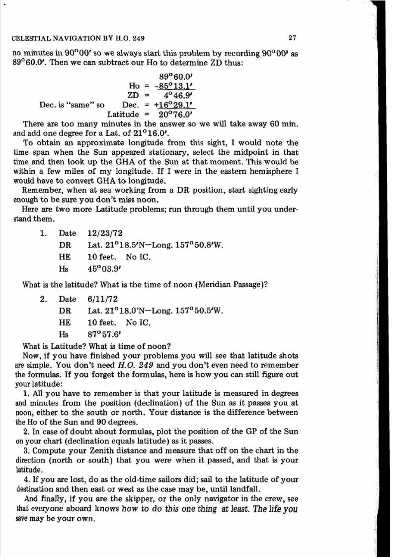
no minutes in 90°00' so we always start this problem by recording 90°00' as89°60.0'. Then we can subtract our Ho to determine ZD thus:
Ho
ZD =Dec. is "same" so Dec.
89°60.0'
= -85°13.1'
4°46.9'= +16°29.1'
20°76.0'atitude =
There are too many minutes in the answer so we will take away 60 min.and add one degree for a Lat. of 21°16.0'.
To obtain an approximate longitude from this sight, I would note the
time span when the Sun appeared stationary, select the midpoint in that
time and then look up the GHA of the Sun at that moment. This would bewithin a few miles of my longitude. I f I were in the eastern hemisphere Iwould have to convert GHA to longitude.
Remember, when at sea working from a DR position, start sighting earlyenough to be sure you don't miss noon.
Here are two more Latitude problems; run through them until you under
stand them.
1. Date
DR
HE
12/23/72
Lat. 21°18.5'N-Long. 157°50.8'W.
10 feet. No IC.
What is the latitude? What is the time of noon (Meridian Passage)?
2. Date
DR
HE
6/11/72
Lat. 21°18.0'N-Long. 157°50.5'W.
10 feet. No IC.
Hs 87°57.6'
What is Latitude? What is time of noon?
Now, if you have finished your problems you will see that latitude shotsare simple. You don't need H.O. 249 and you don't even need to rememberthe formulas. I f you forget the formulas, here is how you can still figure out
your latitude:1. All you have to remember is that your latitude is measured in degreesand minutes from the position (declination) of the Sun as it passes you at
noon, either to the south or north. Your distance is the difference betweenthe Ho of the Sun and 90 degrees.
2. In case of doubt about formulas, plot the position of the GP of the Sunon your chart (declination equals latitude) as it passes.
3. Compute your Zenith distance and measure that off on the chart in the
direction (north or south) that you were when it passed, and that is your
latitude.
4.I f
you are lost, do as the old-time sailors did; sail to the latitude of yourdestination and then east or west as the case may be, until landfall.And finally, if you are the skipper, or the only navigator in the crew, see
that everyone aboard knows how to do this one thing at least. The life yousave may be your own.

5/8/2018 Celestial Navigation by H. O. 249 1974 Milligan 0870331914 - slidepdf.com
http://slidepdf.com/reader/full/celestial-navigation-by-h-o-249-1974-milligan-0870331914 34/106
v. LINE OF POSITION (LP)-FIX
Let us assume that we are cruising along an unfamiliar shore searching forthe enuance to a small hideaway harbor which we have located on the chart.We cannot see the entrance to the harbor, but we do identify a large water
tank inland that we find on the chart. From this tank we can plot a Line of
Position (LP) by simply taking a bearing on it with our pelorus. I f we have
no pelorus, we can simply head the boat toward the tank and read the
compass. Let us assume that we do this and the tank bears 43 degrees true
from our position. I f we then add 180 to the 43 degrees we will obtain areciprocal, or opposite, bearing from the tank to us. This is a bearing of 223
degrees. We plot this on the chart from the tank and it becomes LP TANK.We are somewhere on this line. This is helpful information, but if we are toplot an accurate course to the harbor we need to know where on the line. To
find out where, we need a second LP which will cross the first, preferably at
an angle close to 90 degrees.
) II
Figure 23
/
I/
/
Next, we spot a church steeple in a small village farther along the shoreand we are able to locate this on the chart and find it bears 3150 from us.
We subtract 1800 from this and obtain a reciprocal of 135 degrees. We plot
this in the same way and obtain a FIX at the point where the two lines cross.From here we can plot a course to the mouth of the harbor in reasonablesafety.
28
p
(
t
I1
!'li
hca
tloVII
ci
insi;
aIis
at
av
01
th
avfre
cosal
sec
sh·th:po
lin
to 'ho
th€
dif
boc
Jthe
anc
fon

5/8/2018 Celestial Navigation by H. O. 249 1974 Milligan 0870331914 - slidepdf.com
http://slidepdf.com/reader/full/celestial-navigation-by-h-o-249-1974-milligan-0870331914 35/106
CELESTIAL NAVIGATION BY H.O. 249 29
Navigators are by habit cautious and like to prove their FIXES by taking athird sight when possible, in order to assure that there is no mistake in either
of the first two lines of position. In our case, le t us assume that we find amountain peak inland, due north and plot a third line of position from this.Now we have a three-point FIX. You will note in this example (Fig. 23), the
lines leave a small triangle at the point where they intersect. A perfect FIXwould have all three lines crossing at exactly the same place, but this seldomhappens in practice. Remember, the boat is probably moving a little fromcurrent or wind even with the engine off or the sails down. Such perfect
accuracy is hard to come by except in theory.
A celestial Line of Position, and a celestial FIX is arrived at in very muchthe same way as in this example, except that celestial bodies are used insteadof terrestrial bodies. Our Nautical Almanac replaces our chart to tell uswhere the bodies are at a given moment in time (GHA and Dec.).
A line of position in celestial navigation is actually a small segment of acirde of position. Let me show you how this comes about.
Assume that we are at a position, 23°00' North Lat. 140°00' West Long.in the Pacific on the way from California to Hawaii. At the moment of our
sight the GHA of the Sun is 120°00' and the Dec. is 20°00' North (allapproximate). We would get an altitude of approximately 70°00' as the Sunis 20 degrees away from our position. At this same time if there were a shipat 100°00' West Long. and at 23°00' North Lat., it would also be 20 degreesaway from the GP of the Sun and would get the same altitude, although anopposite azimuth. A ship north or south the same distance would also getthe same altitude. To put it another way, any ship on a circle of 20 degreesaway from the ground spot of the Sun would get the same altitude readingfrom a sight. Thus, one sight alone results in a circle of position. A boat
could be anywhere on the circle 20 degrees away from the Sun and get the
same altitude reading. I f we take a sight on a second object we can create asecond circle of position which will intersect the first in two places. We
should know from our DR which intersection represents our position, but athird sight will intersect at only one of the first points and confirm our
position. In practice we do not construct a circle, but only a short straightline representing a segment of the circle. The tables give us an azimuth
toward the heavenly body and this is sufficient for our purposes. Let's seehow it works.
Step by Step to a Line of Position
We will still be using the Sun. I t is a big bright ball and easy to find whenthere are not too many clouds. We can also use it for three different sights at
different times and get a pretty good three-point FIX with just this one
body, but let us calculate an LP before we get into that.
The steps are:1. Time is important. Check your timepiece and record the error down to
the second. For this example le t us say that we have tuned in on 5 megahertzand determined that our watch is 20 seconds fast. We are sailing from California to Hawaii, and our watch is set to Pacific Coast Time. The month is

5/8/2018 Celestial Navigation by H. O. 249 1974 Milligan 0870331914 - slidepdf.com
http://slidepdf.com/reader/full/celestial-navigation-by-h-o-249-1974-milligan-0870331914 36/106
30 LINE OF POSITION (LP)-FIX
July. A look at the "Standard Time" section of the Almanacwill inform usthat the Pacific Coast is on Daylight Saving Time during July.
2. Now, up on deck with pencil and paper. (We will work with a work
sheet later.) Find a comfortable place where you can brace yourself againstthe motion of the boat, then check and record IC and Height of Eye.
3. Estimate the altitude of the Sun and set the sextant at that altitude.Select a Sun filter and move it into place. Now, look at the horizon through
the scope and see whether the Sun is there near the horizon. I f not, releasethe index arm and move the arm forward and back until you find it. If you
still don't see it you are probably not pointing the sextant directly towardthe Sun. Look around, it's there somewhere. When you find it, you may
want to change the filter. The light should be screened enough so that it iscomfortable to look at but still sharp and clear.
4. Take your sight just as you did for the noon shot. Some navigators liketo place a morning sun (one that is rising) just below the horizon and wait
for it to come up to position. An afternoon shot would be taken by placingthe sun just above the horizon and letting it drop into position. I prefer to
bring it slightly above, swing my sextant to find the bottom of the arc, andthen screw it down until it touches.
5. I f you have a helper, he will be holding the watch. You will call,"Ready" and then "Mark" as you bring the lower limb of the sun in tangent
with the horizon. I do not generally use a helper. I wear my watch on my
left wrist which is right in front of my eye as I adjust the sextant. I estimatethat it takes me one second to focus my eyes from the Sun to the watch. Isubtract the second from the time that I read. In checking the time, pick up
the position of the second hand first, then the minutes and finally the hour.
At morning or evening twilight you will be better with a helper to read not
only the time, but the sextant as well. A flashlight may be needed for this,and the navigator taking the sight should keep his eyes dark adapted so the
stars will be easier to find.
If the sea is rough, or if for any reason you doubt your sight, take two or
three during a span of a few minutes and work them all out for an average. If
one is obviously bad, throw it out and don't use it.6. Record the time and the altitude of your shot, or shots and return to
the cabin.
Now it is time to introduce the work sheet (Fig. 24). You will note that
the upper section is a heading of general information needed as a passageprogresses. I have not numbered these lines. Below the heading each line isnumbered and we will proceed with our steps from here by the line number
on the work sheet. (Note: Fig. 24 is on page 34.)
Line 1-1 have recorded the DR position; Lat. and Long.Line 2-This is my IC and HE.Line 3-The body is the Sun. I use the symbol for the Sun.Line 4-1 record my Hs.Line 5-My correction for HE and IC.
Line 6-My App. Alt.Line 7-My correction for the App. Alt.Line 8-My Ho.Line 9-The time of my sight by day, hour, minute and second.
p
(
c
n
le
SI
Row
rasi:
o

5/8/2018 Celestial Navigation by H. O. 249 1974 Milligan 0870331914 - slidepdf.com
http://slidepdf.com/reader/full/celestial-navigation-by-h-o-249-1974-milligan-0870331914 37/106
CELESTIAL NAVIGATION BY H.O. 249 31
Line 1 (}-My watch was 20 seconds fast so my correction for this is -20s.Line 11-1 have converted to GMT from Pacific Coast time and have made
my watch correction.The next section of the work sheet is headed "DECLINATION-FROM
THE ALMANAC."
Line 12-1n my Almanac I find July 11 on page 139. Under the heading"SUN" I find the 17th hour and read the Dec. there as 22°01.9'. I recordthat on this line.
Line 13-This is the Dec. correction for minutes and seconds of time. Ineed to know first which way Dec. is changing, so I look at the Dec. for the
18th hour and find that it is smaller, therefore, Dec. is decreasing so I circlethe (-) sign on this line and then from the very bottom of the Sun column Ipick up and record the code "d" of 0.4. This is a multiplication factor, and it
will help me find the Dec. change for 35 min. 47 sec. I will not find the
correction until I turn to the minute pages, which I will do after I get my
GHA in the next section.Line 14-This is where I computed final Dec. after I got the correction.Line 15-1n the GHA section of the work sheet I read the GHA after the
17th hour on the July 11 page where I found the Dec. I recorded it here and
then turned to the 35 minute page in the back of the Almanac.
Line 16-0n the 47 sec. line of the 35 min. page I read: 8°56.8'. This is
the distance the Sun moved in 35 minutes and 47 seconds. I recorded it here.Line 17-We will meet the "v" correction to GHA when we get to the
Planets and the Moon. I t does not apply to the Sun so we leave this line
blank and add up our GHA figures.
Line 18-Record the answer here.Now, while we are on the minute page, look at the right hand half of the
35 minute section and down the v-d corr. column until we find the 0.4 that
we recorded on line 13. We find it just the fifth number down in the firstcolumn of v-d corrections and after it is our corr. of 0.2. We now record this
on line 13 , and then subtract it from line 12 for a final Dec. on line 14 .
Line 19-This line moves into a new section of the work sheet and, for the
moment we are through with the Almanac. On this line I have assumed alongitude that has exactly the same minutes as appears in the GHA of the
sun. We will compute our LHA from our Assumed Long., and as the Sight
Reduction Tables, (H.O. 249 Vol. l / ) are designed for entry in whole degreesof LHA, we must assume a position that will give us whole degrees. I f wewere in the eastern hemisphere, where as you will remember, longitude
reduces in number as one moves west, while GHA increases, we would assume
a number of minutes which when added to the minutes of GHA would equalsixty. This would give us whole degrees of LHA for the eastern hemisphere.Our next problem will be in the east, so we can see how it works there whenwe go on.
Line 20-1 have recorded my LHA. Do you remember the formula? I t goeslike this with an added note on minutes:
+ east east minutes = 60LHA = GHA longitude-
- west west minutes =0

5/8/2018 Celestial Navigation by H. O. 249 1974 Milligan 0870331914 - slidepdf.com
http://slidepdf.com/reader/full/celestial-navigation-by-h-o-249-1974-milligan-0870331914 38/106
32 LINE OF POSITION (LP)-FIX
MyprolJlem, then, looked like t h i ~ : GHA = 82° 34.7'
Minus west Long. 139°34.7'
In order to subtract, I must add 360 degrees to the GHA to make it large
enough. My problem is now like this:
GHA = 442°34.7'
- 139°34.7'
LHA = 303°00.0'
Line 21-Here again the tables are designed for entry by whole degrees of
Lat., so we will assume the nearest whole degree of 25° .Line 22-once more the tables must be entered with whole degrees. We
will therefore assume the whole degree of Dec. as shown on line 14. We willhave to consider the remainder of the Dec. figure, however, so:
Line 23-We will record it here.
We now have all that is necessary for entering the tables, so to H. O. 249,
Vol. II .
There are three places where I said we would need whole degrees to getinto the tables; Lines 20, LHA, 21, Lat. and 22, Dec. We go in first with Lat.
I f you will thumb through your H.O. 249 Vol. II you will see that the
first 12 pages numbered with Roman numerals are introductory pages.Following the introduction you will find pages labeled "LAT." There are
several pages for each LAT. Open the book to pages headed with our as-
sumed Lat. of 25°. This Lat. section begins on page 150.I f
you will thumbahead you will see that Lat. 25 runs through page 155. Page 153 is the one
we want. Turn to it and we will see why. Turn the book sidewise so that the
printing is properly oriented and you will see across the top of the pageheading: "DECLINATION (15-29) SAME NAME AS LATITUDE." We want
this page for three reasons. First, our Dec. is 22° and that falls between 15
and 29. Second, if you will look down the far right column headed LHA you
will find that our LHA of 303° is there. Third, the word "SAME" is in the
title. I f you will check the title on page 152 you will see that it is "DECLINATION (15-29) CONTRARY NAME TO LATITUDE." The "SAME"
meansthat the
Dec.of the body we
are sighting is inthe
same hemisphere,north or south, as our latitude. The "CONTRARY" is for a body in the
opposite hemisphere. Our position is north, the Sun's Dec. is north, therefore we want the page marked "SAME."
Running across the top of page 153 right under the heading are columnsof figures of numbers from 15 to 29. This is for Dec. and as our Dec. is 22°
we want that column. Now, look down the right hand column headed LHAuntil we find our 303. Place a straight edge under 303 to mark it and then
look under the Dec. column of 22°. You will find three sets of numbers inthat space. Glance at the top of the column and you will see that they are
subheaded: Hc, d, and Z. Back down on the 303 LHA line we read under Hc,38°01'. Under d we read 16, and under Z, 81.
Line 24-We copy these three numbers in the spaces provided for them
here.The Hc figure represents what our Ho would be if we were at Lat. 25°
exactly; at an LHA of exactly 303° and if the Dec. were exactly 22°. The

5/8/2018 Celestial Navigation by H. O. 249 1974 Milligan 0870331914 - slidepdf.com
http://slidepdf.com/reader/full/celestial-navigation-by-h-o-249-1974-milligan-0870331914 39/106
CELESTIAL NA VIGATION BY H.O. 249 33
"d" is a factor to go with our Dec. remainder to correct for the exact
declination. The "Z" will give us a direction toward the GP of the Sun.Let's go on and work it out.
Line 25-This is for the Dec. correction and I must first see if it is a plus or a
minus. You will note that there is a plus (+ ) or a minus (- ) sign with the cor
:rection. In this case it is a plus (+ ) so I mark mine with a + sign on
this line. Next, the last page of H.O. 249 is a table numbered 5. There should
be a second copy of this on a card that came with your volume. Table No. 5
has numbers across the top from one through 60. Down each side are numbers from 0 through 59. You have two numbers to work with, your Dec.
remainder and the d factor on line 24. The Dec. remainder of 1.7 is closer to
2 than to 1 so we will change it to 2 as the table doesn't handle tenths.
Across the top of Table No. 5 we find our d factor of 16. Reading down the
side we find 2. In the space where these two coordinates meet we find acorrection of 1. This is one minute so we record it on line 25 in the spaceprovided.
Line 26-By adding lines 24, and 25, we have a corrected Hc.
Line 27-This is my Ho which I brought down from line 8.
Line 28-1 next compare my Hc and my Ho. I note that my Ho is larger.
I t is quite easy to visualize, I think, that when an object in the sky is far
away it will appear lower in the sky than when it is near. We learned that this
was so with our noon shot. I f we are at the GP of the body it will be directly
overhead at 90 degrees. The farther away it is, the lower it will be when we
measure its altitude.
In comparing our Ho with Hc we make the same kind of a check. In thisinstance our Ho is larger than Hc, which means that we are closer to the
body than if we were at the assumed position. This being so , I circle the T on
line 28 to indicate that we are "Toward" the body from our assumed posi
tion. I f Ho had been smaller, I would have circled the A for "Away" from
the assumed position.
Now, I will subtract the smaller from the larger and see how far toward.
My answer is on:
Line 28-51 minutes of arc equals 51 miles, therefore, my line of position
will be drafted 51 miles toward the GP of the Sun from my assumed posi
tion.Back on line 25 to the right of the corr. is a Zn that needs to be figured
out. In H.O. 249 on page 153 where we found our Hc we can find a formula
for converting the Z to a Zn. (Azimuth).
At the top left corner is a formula as follows:
LHA greater than 1800••••• Zn = Z
N. Lat.
LHA less than 1800. . • • • . . . Zn = 360 0
- Z
Our LHA is greater, so our Zn is the same as Z, or 81 0 .

5/8/2018 Celestial Navigation by H. O. 249 1974 Milligan 0870331914 - slidepdf.com
http://slidepdf.com/reader/full/celestial-navigation-by-h-o-249-1974-milligan-0870331914 40/106
WORK SHEET - - - - - - - - - - SOLAR SYSTEM
DATE 0 ! ~ f f / ~ COURSE %0
MILES RUN LAST POSITION_______________
MILES MADE GOOD
LOG I, If 'P »u.?
TOTAL MILES RUN
2- IC 0 HE i.,/ IC HE
3- Body 0oStf' c -:21.{)
f
4- Hs
Body
Hs
s- IC & HE ,t, i. '6- App. Alt. :Jl.J 3: sE· ,Z..
le & HE
App. Alt .7- corr . -; !:i:',i I8- Ho i ~ Q / f . . . a
corr .Ho
TIME OF OBSERVATION
9- 11 d....&..h 'Oh m D7 s10- watch corr. - ,;le; Sd h m s---------atch corr .-------
GMT d h m s- - - - - - -- - --DECLINATION - - - FROM ALMANAC
12- mo.-day-hour ..t.!l" 619/ AI mo.-day-hour__________
13- code d ~ c o r r & ; > Q.g.. code d corr • ::±_______14- DEC. Jee? 01.7 f' DEC._____
GHA ------------FROM ALMANAC
15- mo.-day-hour Zi.. .. 37. f- mo. -day-hour
16- min.-sec. f. : [ ' ~ . f ' min.-sec.
17- code v corr± code v corr±
18- GHA £'rA" 31,7 GHA
19- A s s ~ Long. /3Y" 31.'/ Ass. Long.
20- LHA -;3636
LHA
21- ASfl. Lat.d'-Sl>
;V Ass. Lat.
22- Ass. Dec. d ' ~ l > y Ass. Dec.
23- Dec. remainder tJl.: 7 1 Dec. remainder
FROM HO 249I
24- Hc 3cfa01 d - L Z ~ Hc d Z-- -----
25- corrS;) vi z n ~ corr± Zn
26- Hc 3J>"og.CJ Hc
27- Ho ay '53 . Cl Ho28- S// A o r@ A or T
Figure 24
34
MILES TO GO
Long.
IC HE
Body
Hs
IC & HE
App. Alt .corr .
Ho
d h m swatch cor r - . - - ---
GMT d h m s--- -- -- ---
mo.-day-hour---------ode d corr.±-------EC._____
mo.-day-hour
min.-sec.code v corr±
GHA
Ass. Long.
LHA
Ass. Lat.
Ass. Dec.
Dec. remainder
Hc
corr± Zn
Hc
HoA or T

5/8/2018 Celestial Navigation by H. O. 249 1974 Milligan 0870331914 - slidepdf.com
http://slidepdf.com/reader/full/celestial-navigation-by-h-o-249-1974-milligan-0870331914 41/106
VI. PLOTTING A LINE OF POSITION (LP)
Let's start by examining Fig. 25. (This plot sheet was designed by Mr.
Louis Valier of 2969 Kalakaua Avenue, Honolulu. Louis taught navigationat the Bishop Museum in Honolulu and has sailed his own boat extensivelythroughout the Pacific over the past many years. The plot sheet has nocopyright, and its design is available to you for your use. I f you are inter-ested in acquiring a supply I would suggest you write Mr. Valier at the aboveaddress. He makes them available in pads at a nominal price.) This is auniversal plot sheet designed to use at any latitude, or longitude where a
Mercator chart is applicable. In blank form it has one horizontal line through
the center and three vertical lines. To make it applicable to the area you are
in you will: No. 1, name the center horizontal line your assumed Lat. In our
problem thisis
25° North. At No. 2, I have named the center vertical mywhole degree of assumed longitude, 139°. The minutes of longitude arealong the scale at the top and bottom of the sheet. At No. 3, I have namedthe two adjacent vertical lines to correspond to the proper longitude. In the
lower left corner of the sheet is a printed protractor. I have marked linesfrom the corner of the sheet through the 26th degree at No. 4, and through
the 24th degree at No. 5, and have measured the length of these lines with apair of dividers to give me the distance to Lat. 26° and 24° from Lat. 25°. I
have drawn in and labeled these lines. The sheet is now ready for use for our
Sun sight.
Now, let us look at Fig. 26. Here I have worked out a line of position(LP).
At No. 1, I have marked in the assumed position. I placed it on Lat. 25°,
and then located, as accurately as I could, 34.7 minutes of longitude to the
left of Long. 139°. I used the Long. scale at the top and bottom of the sheet
for this. I labeled the point"AP" for Assumed Position.Now, with a protractor I measured off 81°, our Zn, (No. 2) and drew a
line from the AP through the point so marked. I put an arrowhead on the
end to indicate direction and then the symbol for the Sun.Back at the work sheet again, on line 28 I picked up 51 mi. "T", or 51
miles toward the Sun from my AP. You will remember when I was discussinglatitude and longitude I pointed out that one minute of longitude equaled
one nautical mile only at the equator. The scale at the bottom left hand sideof the plot sheet running from 0 through 60 would be our mileage scale at
the equator. To get the scale for any other latitude, a line is drawn from the
left lower corner of the protractor through the degree, equal to the degree of
latitude at the AP. Then measurement is made along the sloping line created.
Ours is the 25th degree. You will note that subdivisions are drawn in up to
30 minutes only. When the mileage measurement is more than that, it can be
measured from the right hand end of the line. This I have done for 51 miles
and then transferred the distance to my Zn line toward the Sun. Next, at No.3, with my protractor, I have drawn in my LP at that point 90 degrees fromthe Zn line. This is my LP. I am somewhere on it .
You might also note that I have indicated my DR position on the plot
sheet.
35

5/8/2018 Celestial Navigation by H. O. 249 1974 Milligan 0870331914 - slidepdf.com
http://slidepdf.com/reader/full/celestial-navigation-by-h-o-249-1974-milligan-0870331914 42/106
5 10
1'1. D
Name this - - - ~ line the ass. Long.
Measure the minutes of Long.
up here, and below.
Lat. 260 here.
Name
the appropriate
- ( j )1M ~ u ' " th••_taore to Lat.24·
--30
Figure 25 (left)
36
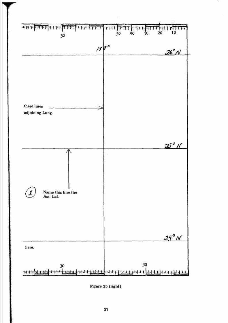
5/8/2018 Celestial Navigation by H. O. 249 1974 Milligan 0870331914 - slidepdf.com
http://slidepdf.com/reader/full/celestial-navigation-by-h-o-249-1974-milligan-0870331914 43/106
these lines
adjoining Long.
(j)
here.
Name this line th e
Ass. Lat.
Cif
Figure 25 (right)
37

5/8/2018 Celestial Navigation by H. O. 249 1974 Milligan 0870331914 - slidepdf.com
http://slidepdf.com/reader/full/celestial-navigation-by-h-o-249-1974-milligan-0870331914 44/106
0)
- R ~ II~ I
"':--\~ ~ I I'<')
' \If
~ ( )
-..JI
30
Figure 26 (left)
38

5/8/2018 Celestial Navigation by H. O. 249 1974 Milligan 0870331914 - slidepdf.com
http://slidepdf.com/reader/full/celestial-navigation-by-h-o-249-1974-milligan-0870331914 45/106
L ~ T 2 e
t i lT 2 f N
""' I"\i,
Figure 26 (right)
39
5/8/2018 Celestial Navigation by H. O. 249 1974 Milligan 0870331914 - slidepdf.com
http://slidepdf.com/reader/full/celestial-navigation-by-h-o-249-1974-milligan-0870331914 46/106
VII. FIX
Just as a single line of position from a point on shore failed to give us anexact FIX, so does a single line of position from a celestial body. We can,however, gleen some worthwhile information from a single line. As welearned earlier, a single line at noon gives us an accurate latitude. A singleline of position when the Sun is astern or ahead will give us a good indicationas to how far along our track we are. I f we are cruising north or south alonga shore, a morning or afternoon LP taken when the Sun is abeam, or nearabeam will tell us how far off shore we are. A morning sight giving us an LPrunning roughly north and south can be crossed with a noon sight for a fairly
accurate noon FIX. To obtain this FIX we would move our morning LP inthe direction we are cruising, equal t o ~ the miles run between the two sights(Fig. 27). This FIX can be further confirmed with an afternoon sight movedback the miles run, for a three point FIX from one body. The FIX will beonly as good as the measurement of miles and direction run, but in the open
ocean away from danger this is not a bad FIX.The moon is available for a sight a good part of the time during daylight
hours, and a second line can be computed from this to cross with a Sun line.Venus, likewise, can sometimes be seen during daylight and thus can be usedwith the Sun and the moon.
When we get to stars, there will be an abundance of heavenly bodies to
choose from for a three point FIX, but we are not into stars yet so let us getback to the Sun and see what will happen when we are in the eastern andsouthern hemispheres. We will take both eastern and southern problems with
a trip from Australia to the West Coast of the United States.We are now sailing off the east coast of New Guinea headed for a stopover
on New Ireland and have worked out a dead reckoned (DR) position of
4°30'S. Lat. 148°40'E. Long. (Fig. 28). The date is May 15, 1972. You canfollow the work sheet from my Hs down through line 8. There are no newproblems here. On line 9, the captain, we find is keeping Queensland,Australia time, and he has to convert to GMT. (He'd cure this problem if hekept a watch on GMT.) The sight is taken at 8:15:12 a.m. I f you will look
up Queensland in the standard time section of the Almanac you will find it
in List 1 at 10 hrs. early on GMT. Ten hours from the 8th hour of the day
takes us back to the previous day at the 22nd hour. GMT then is the 14th of
May and this is shown on line 11 of the work sheet.
We next extract Dec. and GHA for that hour, check the direction of Dec.change, and then pick up the d code and turn to the minute page. Note that
in adding the minutes of GHA there are 103.6 minutes, so 60 are subtracted
and one degree is added.Now for the LHA problem. I must remember two differences from the
first problem in the western hemisphere. 1. I must assume a number of
minutes and tenths which will equal 60 when added to GHA rather than
using the same number of minutes and tenths. 2. I will then add the assumed
40

5/8/2018 Celestial Navigation by H. O. 249 1974 Milligan 0870331914 - slidepdf.com
http://slidepdf.com/reader/full/celestial-navigation-by-h-o-249-1974-milligan-0870331914 47/106
CELESTIAL NAVIGATION BY H.O. 249 41
Long. to the GHA to get LHA rather than subtract it. Remember the formula? I t is in the early pages of the text and goes thus:
- westLHA = GHA longitude.
+ east
Here is our problem:
GHA 154°43.6'
Ass. Long. = + 148°16.4'
302°60.0'
LHA 303°
The problem is then completed just as in the first example.When making this plot (Fig. 29) note first that Lat. and Long. are num
bered in reverse as compared with a plot in the western and northern hemispheres. As for "Z," if you will turn to page 29 in your H.O. 249 Vol. IIwhere the Hc, d and Z are located, you will see the formula for converting Zto Zn in the southern hemisphere at the bottom left corner of the page.
I t reads thus:
LHA greater than 180° ..... Zn = 180 - ZS. Lat.
LHA less than 180° ..... Zn = 180 + Z
In this problem, LHA is greater, so Z is subtracted from 180 for a Zn of
67°.
I hope you haven't been loafing, but if you have, I'll get even with you
now.The next two exhibits, Figs. 30 and 31 are pages from the 1972 Almanac.
There is a daily page and a minute page. You have four extra spaces on the
work sheets used as exhibits up to now. I'll let you use two of those spacesfor sights of your own which I want you to take and compute. The other
two spaces can be used to solve the following problems.
One: Hs, Lower Limb: 17°40.0'
The date is August 20, 1972.DR = Lat. 28°10' N., Long. 130°30' W.
Time = Pacific Coast Daylight Saving, 8:40:10 a.m.IC = O.
HE = 9 feet.The answer is: 7.9 Mi. Away. You work it out to the same answer.
Two: Hs, Lower Limb: 48034.5' (')
The date is August 21, 1972.
DR = Lat. 27°00' N., Long. 133°45' W.
Time=
Pacific Coast Daylight Saving, 4:41:50 p.m. (16:41:50).IC = O.
HE = 12 feet.The answer is: 4.2 Mi. Toward. Can you prove it?

5/8/2018 Celestial Navigation by H. O. 249 1974 Milligan 0870331914 - slidepdf.com
http://slidepdf.com/reader/full/celestial-navigation-by-h-o-249-1974-milligan-0870331914 48/106
P / ~
30
r h t r ~ : r f r t 1 1 # J J t 4 4 4 ! L ' I ' I ' I ' J I ' u p 1 ~ Figure 27 (left)
42

5/8/2018 Celestial Navigation by H. O. 249 1974 Milligan 0870331914 - slidepdf.com
http://slidepdf.com/reader/full/celestial-navigation-by-h-o-249-1974-milligan-0870331914 49/106
r l*, H 'I" "
DISTANCE RUN BETWEEN SIGHTS
MEASURED HERE
Figure 27 (right)
43

5/8/2018 Celestial Navigation by H. O. 249 1974 Milligan 0870331914 - slidepdf.com
http://slidepdf.com/reader/full/celestial-navigation-by-h-o-249-1974-milligan-0870331914 50/106
WORK SHEET - - - - - - - - - - SOLAR SYSTEM
MILES RUN LAST POSITIONATE2!1aq / j - /tf7hCOURSE,1 a i'$- 0 T MILES MADE GOOD -----------
LOG ______ TOTAL MILES RUN ___________ ~ M I L E S TO GO
1- DR Lat .1() Jp lSDR Long./i'f '4'd',E COMPUTED: Lat._____ Long._ _ _ _ _
2- IC --0, ~ "HE I ~ "3- BodY-..::Q::;..·__
4- Hs c;!'1C>!5. 115- IC & HE - 3.36- App. Alt . ~ r o a.Q7- corr . -t /1· 38- Ho ~ r ' .g4.3
9- - .LLd aY h / , , ) - m ~ s 10- watch corr . 6
IC HE
Body
Hs
IC & HE
App. Alt .corr .
Ho
TIME OF OBSERVATION
d h m s---------watch corr .------GMT d h m s-- -- -- --
DECLINATION - - - FROM ALMANAC
12- mo.-day-hour {l'41.3 AI mo.-day-hour_-.,....__
13- code dO.·b corr . Ci ,Z , code d corr ._±_ _ _ _ _14- DEC. IY" ~ 9 . J DEC._____
GHA ------------FROM ALMANAC
15- mo.-day-hour /.R)G (Js.r;; mo.-day-hour
16- min.-sec. 3 ::1(:.6 min.-sec.
17- code v corr± code v corr±
18- GHA -4" ':J. 6. I/2 =1.., GHA
19- A s s ~ Long. !:£.t."It!, , f Ass. Long.
20- LHA J(J3d
LHA
21- ASR. Lat. 4° S Ass. Lat.
22- Ass. Dec. / ~ o /V Ass. Dec.
23- Dec. remainder 49·) 7 Dec. remainder
FROM HO 249
IC HE
Body
Hs
IC & HE
App. Alt .corr .
Ho
d h m s--------watch corr .- - - -GMT d h m s--------
m o . - d a y - h o u r _ ~ __code d corr . ±- - - -EC.______
mo.-day-hour
min.-sec.
code v corr±
GHA
Ass. Long.
LHA
Ass. Lat .
Ass. Dec.
Dec. remainder
24- Hc ~ ' i . , 4/; d-'.L.Z .il.l.. Hc d Z Hc cl Z; ---- -- - - - - - - - - - --- ----
c o r ~ ~ ~ 5- I Zn , corr±
26- Hc .2 ~ t Z.() Hc
Zn corr±
Hc
Zn
27- Ho ,29 C,Z 10 ·3 eN Ho28- -7 or T
Ho __________A or Tor T
Figure 28
45

5/8/2018 Celestial Navigation by H. O. 249 1974 Milligan 0870331914 - slidepdf.com
http://slidepdf.com/reader/full/celestial-navigation-by-h-o-249-1974-milligan-0870331914 51/106
30
r h t L ~ t I M t h f j J I 4 4 * r t - r t - ¥ ; I ' t x f : d : [ 4 l # # ¥ Figure 29 (left)
46

5/8/2018 Celestial Navigation by H. O. 249 1974 Milligan 0870331914 - slidepdf.com
http://slidepdf.com/reader/full/celestial-navigation-by-h-o-249-1974-milligan-0870331914 52/106
3"
,L/J[. t) S
@Dt<.
Figure 29 (right)
47

5/8/2018 Celestial Navigation by H. O. 249 1974 Milligan 0870331914 - slidepdf.com
http://slidepdf.com/reader/full/celestial-navigation-by-h-o-249-1974-milligan-0870331914 53/106
1972 AUGUST 19. 20. 21 (SAT • SUN .• MON.)
SUN MOON Lat.Twilight Sun-
G.M.T. Naut. Civil rise 19
G.H.A. Dec. G.H.A. v Dec. d H.P. 0 h m h m h m h m
d h 0, 0 ,
0, , 0 , , , N72 1111 1111 02 56 -9 00 179 05·4 N12 49-1 71 19·8 9·9 526 04·6 0·6 54·7 N70 1111 01 35 03 21 -1 194 05·5 48·3 85 48'7 9·9 26 05·2 0'6 54·7 68 /11/ 02 17 03 40 -2 209 05·7 47'5 100 17-6 9'8 26 05·8 0'4 54·8 66 //11 0246 03 55
-3 224 05·8 .. 46'7 114 46·4 9'8 26 06·2 0'3 54·8 64 01 23 03 06 04 07
-04 239 06·0 45'8 129 15·2 9'8 26 06·5 0·1 54·8 62 02 02 03 23 04 17 18 2005 254 06·1 45·0 143 44·0 9·7 26 06·6 0·0 54·8 60 02 27 0337 04 26 1743
06 269 06·2 N12 44·2 158 12·7 9·7 526 06·6 0·1 54·8 N58 0247 03 48 04 34 17 17
S 07 284 06·4 43-4 172 41·4 9·7 26 06·5 0'2 54·8 56 03 03 03 58 04 40 1656
08 299 06·5 42·6 187 10·1 9'7 26 06·3 0'4 54-9 54 03 16 04 07 04 47 1639
A 09 314 06·7 .. 41·8 201 38·8 9·7 26 05·9 0'5 54·9 52 03 28 04 15 04 52 1624
T 10 329 06·8 40·9 216 07'5 9'6 26 05'4 0'7 54-9 50 03 37 04 22 04 57 1611
U l l 344 07-0 40'1 230 36·1 9'6 26 04·7 0'7 54-9 45 03 58 04 36 05 07 1545
R 12 359 OH N12 39·3 245 04'7 906 526 04·0 0·9 54-9 N 40 0413 04 48 05 16 1524
DB 14 07·3 38'5 259 33-3 9'6 26 03·1 1·1 55·0 35 04 25 04 57 05 24 1507
A 14 29 OH 37-7 274 01-9 9'5 26 02·0 1·1 55·0 30 04 36 05 05 0530 14 52
Y 15 44 07-6 . . 36'8 288 30'4 9'6 26 00·9 1'3 55·0 20 04 52 05 19 0541 14 2616 59 ON 36·0 302 59·0 9·5 255% 1·5 55·0 N10 05 04 05 29 05 51 14 0417 74 07·8 35·2 317 27'5 9'6 25 58·1 1'6 55·0 0 05 14 0539 06 00 13 44
18 89 08·0 N12 34'4 331 56·1 9·5525
56'5 1'7 55·1510
05 230547
06 09 13 2319 104 08·1 33-6 346 24-6 9·5 25 54·8 1·8 55·1 20 0530 05 56 06 18 13 01
20 119 08·3 32-7 053-1 9'4 25 53·0 2·0 55·1 30 0536 06 04 06 29 1236
21 134 08·4 . • 31·9 15 21·5 9·5 25 51·0 2·1 55·1 35 0539 06 09 0635 12 2122 149 08·6 31-1 29 50·0 9·5 25 48·9 2'2 55·2 40 0542 06 14 0641 12 0423 164 08·7 30·3 44 18·5 9'4 25 46·7 2'4 55·2 45 0545 06 19 0649 11 43
2000 179 08·9 N12 29·4 58 46-9 9·5 525 44·3 2·5 55·2 550 0548 06 25 06 59 11 16
01 194 09·0 28·6 73 15'4 9·4 25 41·8 2'6 55·2 52 0549 06 28 07 03 11 0302 209 09·2 27'8 87 43'8 9·5 25 39·2 2'8 55·2 54 05 50 06 31 07 08 1049
03 224 09·3 .. 27·0 102 12·3 9·4 25 36·4 2·9 55·3 56 05 51 0634 0713 1032
04 239 09·5 26·2 116 40·7 9'5 25 33·5 3·0 55·3 58 05 52 06 38 07 19 1011
05 2540% 25·3 131 09-2 9·4 25 30'5 3·2 55·3 560 05 53 0642 07 26 0945
06 269 09·r, N12 24·5 145 37-6 9-4 525 27·3 3·3 55·3Twilight
07 284 09 ~ 23·7 160 06·0 9·4 25 24·0 3·4 55·4 Lat.Sun-
S ~ 299 10·1 22·9 174 34·4 9'5 25 20·6 3'6 55·4 set Civil Naut. 19
314 10·2 • . 22·0 189 02·9 9·4 25 17·0 3·7 55·4U 10 329 10·4 21·2 203 31-3 9·4 25 13-3 3-8 55·4 0 h m h m h m h m
N ll 344 10·5 20·4 217 59'7 9·5 25 09'5 4·0 55·5 N72 21 06 //11 lilt
-12 35910·7 N12 19'5 232 28·2 9-4 525 05'5 4·1 55'5 N 70 2042 22 24 11// -B 14 10·8 18·7 246 56-6 9·5 25 01·4 4·2 55·5 68 20 24 21 44 /11/ - 14 29 no 17'9 261 25·1 9·4 24 5702 4·4 55'5 66 20 10 21 18 lilt -5 441H .. IH 275 53'5 9·5 24 52·8 4'5 55-6 64 19 58 20 57 22 36 -6 59 11-3 16·2 290 22·0 9'5 24 48·3 4·6 55·6 62 19 48 2041 22 01 21 3517 74 11·4 15'4 304 50·5 9·4 24 43·7 4·8 55·6 60 19 39 20 28 21 36 22 12
18 89 IH N12 14·6 319 18·9 9·5 52 4 38·9 4·9 55-6 N58 19 31 2016 21 17 2238
19 104 11·7 13-8 3334704 9'5 24 34·0 5·0 55·7 56 19 25 20 07 21 02 22 5920 119 11·9 12·9 348 15'9 9'5 24 29·0 5'2 55·7 54 19 19 19 58 2048 23 16
21 134 12·0 .. 12'1 2 44·4 9·6 24 23·8 5·3 55'7 52 19 14 19 51 20 37 23 3022 149 12·2 11-3 17 13-0 9'5 24 18·5 5·4 55·7 50 19 09 19 44 20 28 23 4323 164 12·3 10'4 31 41·5 9'5 24 13-1 5·6 55·8 45 18 58 19 30 20 08 24 09
2100 17912·5 N12 0% 46 10·0 906 524 07'5 5'7 55·8 N40 18 50 19 18 19 53 243001 194 12-7 08·8 6038·6 9'6 24 01-8 5·8 55·8 35 18 43 19 09 1940 24 4702 209 12·8 07-9 75 ON 9·6 23 56·0 5·9 55·8 30 1836 19 01 19 30 00 0903 224 13·0 . • OH 89 35·8 9'6 23 50·1 6·1 55-9 20 18 25 1848 19 14 0034
04 239 13-1 06·3 104 04·4 9·6 23 44·0 6'2 55-9 N10 18 16 1837 19 02 0056
05 254 13-3 05·4 118 33·0 9·7 23 37·8 6'3 55-9 0 18 07 18 28 18 52 0117
06 269 13 4 N12 04-6 133 01·7 906 523 31·5 6'5 56·0 510 17 58 18 19 18 44 01 3707 284 13-6 03-8 147 30'3 9·7 23 25·0 6·6 56·0 20 17 49 1811 18 37 01 5908 299 13-7 02·9 161 59·0 9'7 23 18·4 6·7 56·0 30 1738 18 03 18 31 02 25
M 09 314 13-9 .. 02·1 176 27-7 9·7 23 11'7 6·9 56·0 35 1732 17 58 18 28 0240
010 329 14·0 01-3 190 56·4 9·8 23 04·8 6·9 56·1 40 17 26 17 53 18 25 02 57N ll 344 14·2 12 00·4 205 25·2 9'8 22 57·9 7·1 56·1 45 17 18 17 48 18 22 0318
D 12 359 14·4 N11 5% 219 54·0 9'8,522 50·8 7'2 56·1 550 17 09 17 42 18 20 0345
AB 14 14·5 58·8 234 22·8 9'8 22 43-6 7·4 56-1 52 17 04 17 39 18 19 03 57Y 14 29 14·7 57·9 248 51·6 9'8 22 36·2 7·5 56·2 54 17 00 17 36 18 18 04 12
15 44 14·8 ..5H 263 20·4 9·9 22 28·7 7'6 56·2 56 16 54 17 33 18 17 04 29
16 59 15·0 56'3 277 49·3 9·9 222H 7'7 56·2 58 1649 1730 18 16 04 5017 74 15·1 55·4 292 18·2 9·9 22 13-4 7'8 56·3 560 1642 17 26 18 15 0516
18 89 15·3 N11 54·6 3064H 9-9 S 22 05-6 8'0 56·3 SUN19 104 15·4 53·8 321 16·0 10·0 21 57-6 8'1 56·3
Day Eqn.ofTlme Mer. Mer.20 119 15-6 52·9 335 45·0 10·0 21 49·5 8'2 56·321 134 15·8 .. 52·1 350 14·0 10·0 21 41-3 8'3 56·4 OOh 12h Pass. Upper
22 149 15·9 51·2 4 43·0 10·0 21 33·0 8·5 56'4 m , m , h m h m
23 164 16·1 50·4 19 12·0 10·1 21 24'5 8·5 56·4 19 03 39 0332 12 04 19 5620 03 25 03 18 12 03 2049
S.D.15·8 d 0'8 S.D. 15·0 15·1 15·3 21 03 10 03 03 12 03 21 40
Moonrise
20 21
h m h m- --21 06
-19 56
19 26 19 20
18 44 18 5418 15 1833
17 53 18 16
17 35 18 0217 19 17 5017 06 173916 55 17 2916 30 17 08
1611 16 5115 55 16371540 16 2515 16 16 0414 56 154514 36 15 28
14 17 15 1113 56 14 5213 31 14 3113 17 14 18
13 01 14 041241 13 46
12 16 13 2512 04 13 1411 50 13 0311 34 12 5011 15 12 3410 51 12 15
Moonset
20 21
h m h m
- --22 28- 23 3722 18 24 1223 00 24 3823 29 24 58
23 50 25 14
24 08 00 0824 23 00 2324 36 0036
24 48 0048
00 09 01 11
0030 01 300047 01 4601 02 02 0001 27 02 2301 49 024302 09 03 01
02 29 03 2002 51 03 3903 15 04 0203 30 04 15
0347 0430
04 07 04 49
04 32 0511
04 45 05 2204 59 0534
05 15 05470534 06 030558 06 22
MOON
Pass.Age
Lower
h m d
0730 10
08 22 1109 15 12
165
22
h m
21 54
2041
20 0319 3619 15
18 5818 44
183218 2118 1218 0417 561740
17 2717 1517 0516481633
16 19
16 0515 50153215 2215 1014 57
14 4014 3114 2314 1214 0113 47
22
h m
23 29
-5 17254300 120038
00 58
01 1401 2801 4001 5002 0002 19
02 3502 4903 0003 2003 3703 53
04 0904 2504 4404 5605 0805 23
054105 5005 59
06 1006 220637
Phase
[ )
01
0:
0;0:
0'
O!
01
O ~ 01OC
11
1:
1;
1;
11
l!11
1 ~ U1 ~ 2(
2l2,
2;21
2.!
212j
lE
21
3(
3l3,3;
34
Po
3/31
lE
3\
4C
4l
4.43
401
45
4E
41
4S
4 ~ 5 ~ 5]
52
53
54
55
56
51
se5 ~ 60

5/8/2018 Celestial Navigation by H. O. 249 1974 Milligan 0870331914 - slidepdf.com
http://slidepdf.com/reader/full/celestial-navigation-by-h-o-249-1974-milligan-0870331914 54/106
INCREMENTS AND CORRECTIONS
• SUN(J (J (J
., PLANETSARIES MOON or Corrn or Corrn or Corr"
d d d
M SUN(J (J (J
41ARIES MOON or Corrn or Corr" or Cor,n
PLANETS d d d
I 0 I 0 I 0 I I I I I I I 5 0 I 0 , 0 I , I I I , ,
11 10000() 10 01-6 932-7 0'0 0·0 6·0 4·1 12'0 8·1 00 10150() 10 16·7 9470() 0·0 00() 6·0 4·2 12'0 8·3
~ 10 00·3 10 01-9 932-9 0·1 0·1 6·1 401 12·1 8·2
1000·5 10 02-1 933-1 0·2 0·1 6·2 4·2 12·2 8·2tJ 10 00-8 10 0204 9 3304 0'3 0·2 6'3 4·3 12'3 8·3
01 10 15·3 10 16-9 947-2 0'1 0·1 6'1 4·2 12·1 84
02 10 15·5 10 17·2 947·5 0·2 0·1 6·2 4·3 12·2 8403 10 15-8 10174 94707 0'3 0·2 6" 44 12" 8·5
D4 10010() 10 0206 93306 0'4 0·3 6'4 4·3 12·4 8-4 04 10160() 10 IN 94H 0·4 0·3 6'4 44 12·4 806
IS 10 0103 10 02-9 9 -33-9 0' 5 0·3 6·5 44 12·5 84 05 10 16·3 10 17-9 948·2 0·5 0·3 6·5 4·5 12·5 8-6
06 10 01·5 10 OH 93401 0' 6 04 606 4-5 12'6 8·5 Ob 10 16·5 10 18·2 9484 0·6 04 6·6 4-6 12·6 8·7
07 la OHl la 034 934·3 0'7 0·5 6·7 4-5 12'7 806 07 10 1&-8 10184 948·7 0·7 0·5 6·7 4-6 12·7 8-8
a1 10020() 10 0306 93406 008 0·5 608 406 12'8 8-6 08 10 IN) 10 18·7 9 48-9 0-8 0·& 6-8 4-7 1208 8-9
D9 10 02-3 10 03-9 934-8 0·9 006 6· 9 4-7 12·9 8·7 09 10 17-3 10 18-9 949-1 0·9 006 6·9 4-8 12·9 8-9
10 10 02·5 10 OH 935-1 1· 0 0·7 7' 0 4-7 13·0 8-8 10 10 17·5 10 19·2 9494 1'0 0·7 7·0 4-8 13'0 90()
11 10 02-8 10044 935·3 1·1 0·7 7·1 4-8 13·1 8-8 11 10 17-8 10194 94906 1·1 0-8 7·1 4-9 13·1 9·112 10030() 10 04·7 935·5 1' 2 0·8 7·2 4-9 13'2 8-9 12 10180() 10 19-7 949-8 1·2 0-8 7'2 50() 13·2 9-1
IJ 10 03-3 10 04-9 935-8 1' 3 0-9 7·3 4-9 13" 90() 13 10 18·3 10 19-9 950'1 1' 3 0-9 703 50() 13·3 9·214 10 03·5 10 05·2 9360() 1· 4 0-9 7·4 50() 13'4 90() 14 10 18·5 10 20·2 950·3 1·4 1·0 7·4 5·1 13·4 9·3
IS 10 03-8 10054 936·2 1' 5 10() 7·5 5-l 13'5 9- l 15 10 18-8 10204 9 50-6 1· 5 10() 7·5 5·2 13'5 9·3lb 10040() 10 05·7 936·5 1' 6 1-1 7' 6 5·1 13·6 9·2 Ib 10 190() 10 20·7 9 50-8 1' 6 1-1 7·6 5·3 13·6 94
17 10 04·3 10 05-9 936·7 107 1-1 7·7 5·2 13·7 9·2 17 10 19·3 10 20-9 9510() 1·7 1·2 7·7 5·3 13'7 9·5IB 10 04·5 10 06·2 9370() 1' 8 1-2 708 5·3 13'8 9·3 18 10 19·5 10 21-2 951-3 108 1·2 708 54 13·8 9·519 10 04-8 10064 937-2 1· 9 103 7· 9 5-3 13·9 94 19 10 19-8 10214 951·5 1· 9 1·3 7·9 5-5 13·9 906
20 10050() 10 06·7 9374 2·0 1-4 8' 0 54 14·0 9·5 20 10200() 10 21-7 9 51-8 2' 0 1-4 8·0 5·5 14'0 9-7
21 10 05·3 10 06-9 937-7 2·1 14 8·1 5·5 14·1 9·5 21 10 20·3 10 21-9 9520() 2·1 1·5 8·1 5·6 14·1 9-822 10 05·5 10 07·2 9 37-9 2'2 1·5 8·2 5·5 14·2 9-6 22 10 20·5 10 22·2 952·2 2·2 1·5 8·2 5·7 14·2 9-823 10 05-8 10074 938·2 2·3 1·6 8·3 506 14·' 9-7 23 10 20-8 10224 9 52-5 2·, 1-6 8·3 5-7 14·' 9-9
24 10060() 1007-7 9384 2' 4 1-6 8·4 5·7 14·4 9-7 24 10210() 10 22-7 95207 2·4 1-7 8' 4 5-8 14·4 100()
~ 10 06·3 10 07-9 93806 2·5 1-7 8· 5 5·7 14'5 9-8 25 10 2103 10230() 9 52-9 2·5 1-7 8·5 5-9 14·5 100()
26 10 06·5 10 08·2 938-9 2·6 1·8 8·6 5-8 14'6 9-9 2b 10 21·5 10 23·2 953·2 2·6 1-8 8' 6 5-9 14·6 10·127 10 06-8 10084 939-1 2·7 1-8 8·7 5-9 14·7 9-9 27 10 21-8 10 23·5 9534 2·7 1-9 8·7 60() 1407 10·2
28 10 070() 10 08·7 939·3 2·8 1-9 8·8 5-9 14·8 100() 28 10220() 1023-7 953-7 208 1-9 8-8 6·1 14·8 10·2
!29 10 07-3 10 08-9 9 3906 2· 9 20() 8· 9 60() 14·9 10·1 29 10 22·3 10240() 953-9 2·9 20() 8·9 6·2 14·9 10·3
130 10 07·5 10 09·2 9 39-8 " 0 20() 9'0 6·1 15'0 1001 30 10 22·5 10 24·2 954·1 "0 2·1 9'0 6·2 15'0 10 4
'll 10 07-8 10094 940·1 '· 1 2-l 9·1 6·1 15·1 10·2 31 10 22·8 10 24·5 9544 ,· 1 2·1 9·1 6·3 15·1 10 4
12 10080() 10 09·7 940·3 '· 2 2-2 9·2 6·2 15·2 10·3 32 10230() 10 24·7 95406 '· 2 2·2 9·2 &4 15·2 10·5
11 10 08·3 10 09-9 940·5 ,., 2·2 ,., 6·3 15· ' 10·3 33 10 23·3 10250() 9 54-9 ,., 2·3 9'3 6-4 15·, 10-6
14 10 08·5 10 10·2 9 40-8 " 4 2·3 9·4 6·3 15·4 10 4 34 10 23·5 10 25·2 955·1 , ·4 2-4 9·4 6·5 15·4 10·7
l5 10 08-8 10 10 4 9410() 3· 5 24 9·5 64 15'5 10·5 35 10 23-8 10 25·5 955·3 '· 5 24 9·5 6-6 15'5 10·7
16 10 090() 10 10·7 941-3 ' ·6 24 9·6 6·5 15·6 10·5 3b 10240() 10 25·7 955-6 ,· 6 2·5 9·6 6-6 15·6 10-8
31 10 09·3 10 10·9 941·5 3· 7 2·5 9·7 6·5 15-7 10·6 37 10 24·3 10 260() 9 55-8 '· 7 2-6 9·7 6·7 15·7 10·9,JI 10 09·5 10 1l·2 941·7 ,· 8 206 908 606 15-8 10·7 38 10 24·5 10 26·2 956·1 '0 8 2-6 9-8 6-8 15·8 10·9
i39 10 09-8 10 11 4 9420() 3· 9 206 9·9 6·7 15·9 10·7 39 10 24-8 10 26·5 956·3 , ·9 2-7 9·9 6·8 15·9 11·0
110 10 100() 10 11-7 942·2 4·0 2-7 10'0 6-8 16'0 10·8 40 10250() 10 26·7 956·5 4'0 2·8 10'0 6-9 16'0 11-1
U 10 10·3 10 11-9 9424 4·1 2·8 10·1 6-8 16·1 10·9 41 10 25·3 10270() 9 56-8 4·1 2-8 10·1 ]o(J 16·1 11-112 10 10·5 10 12·2 9 42-7 4·2 2·8 10·2 6-9 16·2 10·9 42 10 25·5 10 27-2 9570() 4·2 2·9 10'2 7-1 16·2 11-2
1I 10 10-8 10124 942·9 4· , 2·9 10" 70() 16" 1l0() 43 10 25·8 10 27·5 957·2 4·, 30() 10·' 7-1 16·' 11-3
il4 10 1lo() 10 12-7 943-2 4·4 30() 10·4 70() 16·4 11-1 44 10260() 10 27-7 957·5 4·4 30() 10'4 7·2 16·4 11-3
ils 10 11-3 10 12·9 9434 4·5 30() 10'5 7- l 16'5 1l·1 45 10 26·3 10280() 9 57-7 4·5 301 10·5 7-3 16'5 11 4
16 10 1l·5 10 13-2 943-6 4·6 301 10'6 7·2 16'6 1l·2 4b 10 26·5 10 28·2 9580() 4·6 3-2 10'6 7-3 16·6 11-5
17 10 1l·8 10 13 4 943-9 4·7 3·2 10·7 7·2 16'7 1l·3 47 10 26·8 10 28·5 958·2 4'7 H 10·7 74 16·7 1106
18 10 120() 10 13-7 94401 4·8 3·2 1008 7-3 16·8 1l·3 48 10 270() 10 28·7 9 58-4 4·8 H 10-8 7·5 1608 11-6
19 10 12·3 10 13·9 9444 4·9 3-3 10·9 74 16·9 1l·4 49 10 27-3 10 290() 958·7 4·9 3-4 10·9 7·5 16·9 11-7
la 10 12·5 10 14·2 9 4406 5' 0 34 11'0 74 17·0 1l·5 50 10 27·5 10 29·2 9 58-9 5·0 3·5 11'0 7-6 17·0 11·81I 10 12-8 10144 944-8 5·1 34 11·1 7·5 17·1 1l·5 51 10 27·8 10 29·5 959·2 5·1 305 11·1 H 17·1 11·8:12 10 130() 10 14·7 945-1 5·2 3·5 11·2 706 17·2 1106 52 10280() 10 29·7 9 59-4 5·2 3-6 11·2 7-7 17·2 11-9'53 la 13·3 10 14-9 945·3 5 · ' 3-6 11·' 706 17· ' 11-7 53 10 28·3 10300() 9 5906 5·, H 11'3 7-8 17'3 120()
54 10 13·5 10 15·2 945·6 5·4 306 11·4 7-7 17'4 11-7 54 10 28·5 10 30·2 9 59-9 5·4 H ll-04 7-9 17·4 120()
SS 10 13-8 10154 945·8 5· 5 3-7 11·5 Hl 17'5 11-8 55 10 28-8 10 30·5 10 00·1 5·5 3-8 11'5 80() 17'5 12·1
56 10 140() 10 15·7 9460() 5'6 3-8 11'6 7-8 17'6 11-9 5b 10290() 10 30·7 10 00·3 5'6 309 11·6 80() 17·6 12-257 10 14·3 10 15-9 946·3 5·7 3-8 11'7 7-9 17'7 11-9 57 10 29·3 10310() 10 00-6 5'7 309 11'7 8·1 17·7 12·2
sa 10 14·5 10 16·2 946·5 Sol 3-9 11'8 80() 1708 120() 58 10 29·5 10 31·2 10 00-8 5·8 4·0 11-8 8·2 17-8 12-3
19 10 14-8 10164 946·7 5· 9 40() 11·9 80() 17·9 12·1 59 10 29-8 10 31·5 10 OH 5·9 4-l 11·9 8·2 17·9 12 4
60 10 150() 10 16·7 9470() 6'0 4-l 12'0 8·1 18·0 12·2 bO 10300() 10 31-7 10 01-3 6'0 4·2 12'0 8·3 18·0 12·5
Figure 31

5/8/2018 Celestial Navigation by H. O. 249 1974 Milligan 0870331914 - slidepdf.com
http://slidepdf.com/reader/full/celestial-navigation-by-h-o-249-1974-milligan-0870331914 55/106
VIII. OTHER MEMBERS OF THE SOLAR SYSTEM
I f you have your Sun shots down pat, and you should by now, planets willnot be too hard to learn. The first problem is how to identify them. Planetsare not always available, for a good part of the time they are in our skyduring daylight, too close to the Sun, and cannot be seen. (Except that
Venus can sometimes be found during daylight.) Somewhere in the first fewpages of the Almanac you will find a section headed "PLANET NOTES." In
my 1972 copy this is on pages 8 and 9. These pages include a chart indicating the position of the navigational planets for each hour of the day throughout the year. The chart is a quick reference indicating which of the planetsare available to you and whether they will be useful at morning or evening
twilight. They change during the year, sometimes quite rapidly. Read thesenotes carefully and study the chart until you understand it well. The instructions for use of the chart are complete on these pages.
I t should be pointed out at this time that morning or evening twilight is
the time for taking sights of planets or stars, although, as noted previously,
Venus can sometimes be found during daylight. The proper time for the
sight is after it has become dark enough to see the body, but before it hasbecome too dark to see the horizon. There is sunrise-sunset, moonrisemoonset data on the right side of each right hand daily page in the Almanac.
Explanatory data in the back of the Almanac tells you how to use it to
predetermine twilight for your position.There are three major differences between taking and computing a planet
sight and a sun sight. They are:One-In taking a sight of a planet (or a star) the body does not sit on the
horizon as with the Sun, but is centered on the horizon.Two-There are frequently "Additional Corrections" for Mars and Venus
throughout the year. These corrections are in a separate column on the
inside front cover of your Almanac just to the right of the column of regularcorrections for stars and planets. They apply to the span of App. Alt. shown
with each additional correction. During the dates when these corrections
apply, the regular correction should be made first, and then the additionalcorrect ion (Fig. 32A).
Three-With the planets, the "v" factor will apply as a correction to GHA.
The code for "v" will be at the bottom of the column for the planets on the
daily page. You must remember that this factor is always a plus (+) to GHAunless the "v" factor has a minus (-) sign before it at the bottom of the dailypage. (This will happen only with Venus.) Now, let's go through a Ven1;ls
sight step by step (Fig. 32B).
In this example, we are sailing down the eastern coast of the United Statesfrom New York to Miami. I t is the twilight before dawn and Venus is bright
in the eastern sky.Now, to the work sheet:
Date: Aug. 28, 1972.
Line I -My DR position is Lat. 39°20'N., Long. 74°00'W.
50

5/8/2018 Celestial Navigation by H. O. 249 1974 Milligan 0870331914 - slidepdf.com
http://slidepdf.com/reader/full/celestial-navigation-by-h-o-249-1974-milligan-0870331914 56/106
WORK SHEET - - - - - - - - - - SOLAR SYSTEM
DATE 0d,./{: /wC O U R S ~ ~ _________MILES RUN LAST POSITION_ _ _ _ _ _ _ _ _ _
MILES MADE GOODLOG _______ TOTAL MILES RUN ________ ~ M I L E S TO GO __
1- DR Lat. JfA2A:1DR Long. 7 4 ' 7 : J t ~ I ! t / ' COMPUTED: Lat.____ Long.___
2- IC ?J HE /5?
3- B o d y ~ I
4- Hs d2J" 6·s-. S-S- IC & HE · - 3,, f
6- App. Alt. (]lyo 3 / 17- corr . - ---,,...,..,,..-!...I_' = 6 ~ 1 8- Ho ,2£0 34./
9- rfT d o.r h-1.Z...m---&....s10- watch corr ."f 4 s
IC HE
Body
Hs
IC & HE
App. Alt .corr .
Ho
TIME OF OBSERVATION
d h m s--------atch corr ._ _ _ __
GMT d h m s---- --- --DECLINATION - - - FROM ALMANAC
12- mo.-day-hour lf i" /3 3 N mo.-day-hour_:--__13- code d a I c o r ~ Cl code d corr .±___
14- DEc. / f tJ /3 , .3 D'Ec.____
GHA ------------FROM ALMANAC
/tJ / d . ~ I15- mo.-day-hour mo.-day-hour
16- min. -sec. -4 !.F: .) min.-sec.17- code vO/ c o r ~ C) code v corr±
18- GHA S " ~ ~ . t . . GHA
19- Ass. Long. 74' ;tCj.t.. ' Ass. Long.
20- LHA c 2 t / ~ LHA
21- ASR. Lat. 394
/1/ Ass. Lat.
22- Ass. Dec. !l/) /1 / Ass. Dec.
23- Dec. remainder L ~ . : , 1 . t' Dec. remainder
FROM HO 249
25-
26-
27-
28-
corr@ 70He,g?6 : J ; t)
HOoZ.?<-3" ·
I
.;;1./
ZnJL
A o r ( ~ . J
He d Z------- --- - - -
eorr± Zn---e
Ho
------- A or T
Figure 32A
51
IC HE
Body
Hs
IC & HE
App. Alt.corr .
Ho
d h m s-------watch corr .-----GMT d h m s--------
mo.-day-hour____ _
code d corr .±~ - - - -DEC •_ _ _ _ _ _ ___
mo.-day-hour
min.-sec.code v corr±
GHA
Ass. Long.
LHA
Ass. Lat.
Ass. Dec.
Dec. remainder
He d Z
eorr± Zn---e
Ho ----- A or T

5/8/2018 Celestial Navigation by H. O. 249 1974 Milligan 0870331914 - slidepdf.com
http://slidepdf.com/reader/full/celestial-navigation-by-h-o-249-1974-milligan-0870331914 57/106
T .-MA R . SUN APR.-SEPT. STARS AND PLANETS DIP
t ; ; ; ~ ~ ; ~ A P P ' - . - . . ~ . Additional- - - - - - -
Lower U ~ r App.Corrn I1!.t.of Co r" Ht.of jHt. of Co
Limb Limb Alt. Limb Limb Alt. Alt, Corrn Eye r Eye Eye rr "
_.- I -- - -- ----- 19729 56 -S:3 V E N U S ~ ~ 008_
S'1
10 20 Jan.I-Feb.29
-S ' I 00
10 33 -s'o4Z
+0-1.10 46 -4 '9
Mar. I,-Apr. 15,
11 00 - 4 -811 14 -4 '7
0 °
11 29 -4 '6 47+0 -2
11 45 -4 'S Apr.16-MaY12
12 01 -4-4 0°
12 18 -4-3 46 3 12 35 -4-1 iMaY 13-MaY27
12 54 -4-1 0 " .
13 13 -4 -0 1110 '4
13 33 -3 '9 41 +0 ' 513 54 -3'8 May,II-June 514 16 -- 3'7 0 °14 40 - 3'6
6 to:515 04 -3 -S
20 t 0 ·615 30 -3 -4
31 +0'715 57 -' 3'3
16 26 - 3'1 )une6-June 29
16 56 - 3' 10°
17 28 - 3'0 4+-0:6
18 02 1 -9 12 -+0'7
18 38 '- 1 .8 22 10 ·8
19 17 -- 1 '7 June30-July 819 58 -2,6 0 °
20 42'2 'S
6 +0:5
21 28 - 1-4 20 -+0 ·6
22 19 - 1 -3 31 to'7
23 13 -- 2-2 JulY9-July 2424 II - 1-1 0 "25 14 - 1 '0 [ I
0'4
26 22 --1'941
i 0 -5
27 36 - 1,8July 25-Aug.19
28 56 _1'7 0 '30 24 " 1.6 ,+ :3
3200 _ 1'5 ~ g 2 0 - o ; ; ; - [)- Addi,lioniJ/3 3 4 S ~ ~ o .3S 40 _-1'3 ~ 4 1 , 0,:'" Cor-re"tioh37 48 - 1'140 08 _ I -I
Oct.6..:uec. 31
42 44 -, 1'00
45 36 -0'942
. 0'1
48 47 --0 ,8
S2 18 _0 '7 MARS
S6 11 0 ,6 Jan _ I-Dec. 31
60 28 - 0'5 0 °6S 08 -0"4 60
~ 0'1
70 11 - 0 '375 34 0 '281 13 0 '1
87 03 0 '090 00
App . Alt_ = Apparent altitude = Sextant altitude corrected for index error and dip .
For daylight observations of Venus, sec page 260.
Figure 328

5/8/2018 Celestial Navigation by H. O. 249 1974 Milligan 0870331914 - slidepdf.com
http://slidepdf.com/reader/full/celestial-navigation-by-h-o-249-1974-milligan-0870331914 58/106
CELESTIAL NAVIGATION BY H.O. 249 53
Line 2-No Index error, and an HE of 15 feet.Line 3-The body is Venus. I have used her symbol.Line 4-An Hs of 28° 35.5' is obtained by splitting the horizon with
Venus.Line 5-Dip is recorded.
Line 6-1 subtract dip and have my App. Alt.Line 7-Now, one of the new problems. Looking down the corr. column
for stars and planets for App. Alt. of 28°31.7' I find a correction of -1.8'.Looking to the right of that column 1 find, between Aug. 20 and Oct. 5, for
App. Alt. readings between 0° and 47° there is an additional corr. of +0.2'. 1put these together for a final corr. of -1.6'. This gives me on:
Line 8-An Ho of 28°30.1'.
Line 9-The time of my sight was 5:17:10 a.m. Eastern Standard Time,
and my watch was 4 sec. slow.Line 1o-Here is the watch error.
Line l l -The time is corrected and converted to GMT.Line 12-ln the Almanac to the Aug. 28 page and to the 9th hour GMT 1
find the Dec. for that hour.Line 13-1 look at the tenth hour and see that Dec. is decreasing so I circle
the minus sign and check the bottom of the page for the "d" factor. 1 recordit on this line.
Line 14-1 didn't compute this until 1 had turned to the minute page and
determined the value of "d" as zero. Then, my final Dec.Line 15-Now, from the daily page 1 have my GHA for the 9th hour of
GMT.
Line 16-Here is the change in GHA for the 17min. 14sec.Line 17-Now we have the "v" code. This is picked up from the bottom
of the page under the Venus column right next to the "d" code.Line 18-My final GHA.Line 19-My assumed Long. with the same minutes as in the GHA.Line 2o-My computed LHA. (Look up the formula.)Line 21-1 assume Lat. 39° as it is the nearest full degree.Line 22-My assumed Dec. (an even degree).Line 23-The Dec. remainder.Line 24-Now, use the H.O. 249 Vol. II in the same way 1 did for the Sun.
First, find the Latitude section, then the Dec. column in the SAME section,and finally the LHA line. At the coordinates 1 find Hc, d, and Z.
Line 25-This is the correction for "d" and the Dec. remainder I found intable No. 5. I t is a +, because, reading at the next higher Dec. column fromwhere I found the information on line 24, 1 found the Hc higher.
Line 26-My final Hc.
Line 27-Ho is brought down and 1 find it higher than Hc so 1 circle the
"T" for Toward.Line 28-And now 1 have the miles toward Venus from my assumed
position. Back on line 25, to the far right, 1 have checked the formula in the
top left corner of the page in H.O. 249 and found that Z was equal to Zn. 1recorded it here to use in my plot which is included (Fig. 33).
(Text continues on page 57.)

5/8/2018 Celestial Navigation by H. O. 249 1974 Milligan 0870331914 - slidepdf.com
http://slidepdf.com/reader/full/celestial-navigation-by-h-o-249-1974-milligan-0870331914 59/106
LONtg.74...,
Ir- -- '-...Zh 88°
pR.
Figure 33 (left)
54

5/8/2018 Celestial Navigation by H. O. 249 1974 Milligan 0870331914 - slidepdf.com
http://slidepdf.com/reader/full/celestial-navigation-by-h-o-249-1974-milligan-0870331914 60/106
\
\
"\t j.JJT aN
Figure 33 (right)
55

5/8/2018 Celestial Navigation by H. O. 249 1974 Milligan 0870331914 - slidepdf.com
http://slidepdf.com/reader/full/celestial-navigation-by-h-o-249-1974-milligan-0870331914 61/106
164 1972 AUGUST 19. 20. 21 (SAT • SUN • MON.)
ARIES VENUS -4·0 MARS +2·0 JUPITER - 2·0 SATURN +0·3 STARS~ _ _ _ _4 -__________ ~ ______ ~ __ ~ ______ ~ ~ ~ ~ ~ __ ~ ~ __ + - ~ ____ ~ ____ ~ ~ __Dec. G.H.A . Dec. G.H .A. Dec. G.H.A. Dec. Name S.H.A. Dec.
d h
19 0001020304
0506
S0708
A 09T 10U 11
R 12D 13A 14Y 15
1617
181920212223
20 ~ ~ 02030405
060708
S 09U 10N 11
D 12A 13Y 14
151617
181920212223
2 q ~ 02030405
0607
M ~ o 10N 11
D 12A 13y 14
15
1617
G.H.A.
327 26'4342 2809
357 31'412 33·827 36·3
42 38·857 41·27243-787 46·2
102 48·611751-1132 53·5
147 56·0162 53·5178 00·9193 03 4208 05-9
223 08·3
238 10·8253 13-3268 15·728 3 18·2298 20'7313 23·1
328 25-6343 28·0358 3().5
13 33·028 35 443 3709
58 40-473 42·88845'3
103 47·8118 50·2133 52'7
148 55·2163 57-617900·1194 02·5209 05·0224 07'5
239 0909254 124269 1409284 17-3299 19-8314 22·3
329 24-7
344 27-2359 29-714 32·129 34-644 37·0
59 39'574 42·089 44-4
104 4609119 49·4134 51-8
149 54-3164 56·8179 59·219501'7
210 OH225 06·6
G.H.A.
o , 0 ,
226 134 N 19 24'3241 13'5 244256 13-6 244271 13·7 .. 24428613·8 244
301 13-9 24'5316 13-9 N19 24'5331 14·0 24'5346 14-1 24 '5
1 14·2 .. 24'516 14·3 24-631 14·4 24-6
46 14'5 N19 24-661 14·6 24-676 14-6 24-691 14·7 . . 24-6
106 14'8 24·6121 1409 24·7
136 15·0 N19 24·7151 15·0 24-7166 15·1 24-7181 15·2 .. 24-7196 15·3 24'7211 15'3 24'7
226 15·4 N19 24·7241 15'5 24·8256 15·5 24·8271 15-6 .. 24·8286 15'7 24·8301 1.5'7 24 ·8
316 15·8 N19 24-8331 15·9 24'8346 15-9 24·B
1 16·0 .. 24-816 16'1 24·B
31 16·1 24·8
46 16·2 N19 24-861 16·2 24·B
76 16'3 24-891 16-4 .. 24-8
106 16-4 24-8121 16'5 24-8
136 16'5 N19 24-8151 16-6 24·8166 16-6 24-8181 16 '7 .. 24-8196 16'7 24-8211 16·8 24-8
226 16·8 N19 24·8
241 16-9 24-8256 16-9 24·B
271 16-9 .. 24'8286 17-0 24-8301 17-0 24·8
316 IN N19 24-8331 IN 24-7346 IN 24-7
1 IN .. 24-716 IN 24'731 17·3 24·7
4617·3 N19 24-761 17-3 24'776 17-4 24'791 17-4 • . 24'6
106174 24·6121 17'5 24·6
o , 0 ,
172 33-1 N11 36'7187 34·0 36·1202 35·0 35'5217 35·9 . . 34·9232 36·9 34·3
247 37-9 33-8262 38·8 N11 33·2277 39·8 32·6292 40·7 32·0307 41'7 .. 31'5322 42·6 30-9337 43-6 30·3
352 44 '5 N11 29-77 45'5 29-1
22 46·5 28'537 474 . . 28·052 48·4 27·467 49·3 26'8
82 50·3 N11 26·297 51·2 25-6
112 52-2 25·1127 53-1 .. 24'5142 54-1 23'9157 55·1 23·3
172 56·0 N11 22'7187 57·0 22-2202 57·9 21-6217 5B '9 . . 21-0232 59·8 204248 00·8 19-8
263 01 ·8 N11 19·2278 02-7 18·7293 03 ·7 IB·l
308 04·6 . . 17·5323 05-6 16'9338 06·5 16·3
353 07·5 N11 15·78 08'5 15·2
23 09·4 14·638 10·4 . . 14·053 11-3 13-468 12·3 12-8
83 13·2 N11 12-298 14·2 1107
11315·2 1H128 16·1 .. 10·5143 17-1 09-9158 18·0 09·3
173 19·0 N11 08·7
188 20 ·0 08·1203 20-9 07-621B 21-9 .. 07·0233 22·8 06'4248 23·8 05·8
263 24'8 N11 05·227B 25·7 04-6293 26·7 OH308 27-6 . . 03 ·5323 28·6 02·9338 29 ·6 02·3
353 30'5 N11 0107831·5 OH
23 32·4 11 00·538 33-4 10 59-9
53 34·4 59-468 35·3 58·8
o , 0 ,
59 01·2 52 3 22·7 249 25'7 N21 25·374 03·7 22·8 264 28 ·0 25·3B9 06-2 22·8 279 30·3 25·4
104 08·8 .. 22 ·8 294 32·5 " 25·411911-3 22'8 309 34'8 25·4
134 13·8 22-8 324 37-1 25·4149 16'3 5 23 22 ·8 339 39·3 N21 25·4164 18'8 22·8 354 41-6 25·4179 21-3 22-8 9 43-9 25·4194 23-9 . . 22·8 24 46 ·1 .. 25'4209 26'4 22·8 39 48'4 25'5224 28·9 22-8 54 50 ·7 25·5
239 31-4 5 23 22·8 69 52 ·9 N21 25·5254 33-9 22·8 84 55 ·2 25·5269 36·4 22·8 99 57 ·5 25'5284 38-9 .. 22·8 114 59-7 " 25·5299 41'5 22·8 130 02·0 25·5314 44·0 22·8 145 04·2 25'5
329 46'5 52 3 22·8 160 06'5 N21 25'5344 49·0 22·8 175 08·8 25·6359 51·5 22-9 190 11·0 25·6
14 54·0 .. 22·9 205 13-3 " 25-629 56'5 22-9 220 15·6 25-644 59·0 22·9 235 17·9 25-6
60 01'5 S 23 22'9 250 20·1 N21 25-675 04·0 22·9 265 22'4 25-690 06·6 22 '9 280 24'7 25·6
105 09,1 . . 22-9 295 26-9 " 25 '7120 11-6 22·9 310 29-2 25·71351401 22-9 325 31·5 25'7
150 16·6 5 23 22·9 340 33'7 N21 25·7165 19-1 22·9 355 36·0 25'71BO 21-6 22·9 10 38·3 25·7195 24-1 . . 22-9 25 40·5 " 25'7210 26·6 22 ·9 40 42·8 25·7225 29·1 22 ·9 55 45·1 25'7
240 31-6 52 3 22-9 70 47-3 N21 25·825534-1 22-9 85 49·6 25·8270 36·6 22·9 100 51·9 25·8285 39·1 .. 23-0 115 54-1 " 25·8300 41-6 23·0 130 56·4 25·8315 44·2 23·0 14558·7 25-8
330 46·7 S 23 23-0 161 01-0 N21 25·8345 49-2 23-0 176 03·2 25·8
o 51'7 23·0 191 05·5 25-915 54·2 . . 23·0 206 07 '8 " 25-930 56·7 23-0 221 10·0 2509
45 59·2 23-0 236 12·3 2509
61 01·7 S 23 23-0 251 14·6 N21 25-9
76 04·2 23·0 266 16'9 250991 06·7 23-0 281 19,1 25-9106 09·2 .. 23·0 296 21'4 " 25-9121 11'7 23·0 311 23'7 25·9136 14·2 23-0 326 25'9 26·0
151 16'7 S 23 23-0 341 28·2 N21 26·0166 19·2 23-0 356 30·5 26·0181 21·7 23-0 11 32-8 26·0196 24·2 .. 23-0 26 35·0 . . 26·0211 26·7 23-1 41 37-3 26·022629·2 23-1 56 39·6 26·0
241 31-7 52 3 2H 71 41-9 N21 26·025634·2 23-1 8644-1 26·0271 36·6 23-1 101 46·4 26-128639-1 .. 23-1 116 48·7 " 26·1
30141-6 23-1 131 50-9 26·13164401 23-1 146. 53-2 26·1
AcamarAchernar
Acrux
Adhara
Aldebaran
AliothAlkaldAI Na'ir
AlnilamAlphard
AlpheccaAlpheratz
AltairAnkaaAntares
Arcturus
Atria
AviorBellatrixBetelgeuse
Canopus
CapellaDeneb
DenebolaDiphda
Dubhe
ElnathEltaninEnifFomalhaut
Gacrux
GienahHadarHamalKaus Aust.
315 41-33354809173 44·425536-8291 24·6
16647·6153 23 ·0
28 21·4276 17·6218 26·5
126 36·9358 15·0
62 37·835345·3113 03·8
146 23·710833·0234 31·2279 05·0271 34·6
264 10·1281 19·949 52·0
183 05·0349 26·3
194 29-4278 51·591 00·134 16·815 5702
172 35·7176 24-1149 31-9328 35·2
84 24-1
Koc.hab 13 7 IB-6
Markab 14 OB ·5
Menkar 314 47·0Menkent 148 43-9Miaplacidus 221 47-4
Mirfak
NunklPeacockPolluxProcyon
RasalhagueRegulusRlgelRigil Kent.Sablk
Schedar
ShaulaSlriusSpica
Suhail
309 24·3
76350954 06-6244 05-4
24532·0
9634 ·720B 16·3
281 41-61403309102 47·5
35015·397 03-3
259 0009
159 03'7
223 15'5
o ,
5 40 24·4
5 57 22-156257-1S 28 55·8N 16 27·5
N 56 06'0
N 49 27-1
547 05·5S 1 12-9S 8 32·3
N 26 48'5N 28 56'5N 8 47·8S 42 26·95 26 22 '5
N 19 19·5S 68 59-1
S 59 25·1N 6 19'7N 7 24·3
S 52 40'5N 45 58·3N 451HN 14 43-5
S 18 07-9
N 61 54 ·0N 28 35·2N 51 29·7N 9 45·1S 29 45-8
S 56 57-85 17 23·5S 60 14-8N 23 20·1S 34 24-1
N 74 16·2N 15 OHN 3 59·2S 36 14·4S 69 36·2
N 49 45-9
S 26 20·0S 56 49·5N 28 05·7
N 5 17-9
N 12 34·8N 12 06·1S 8 13-7
S 60 43·7S 15 41 '0
N 56 23·3S 37 05·3
S 16 40'5S 11 01·2
S 43 19-2
18 240 09-119 25511·520 270 14·021 285 16·522 300 180923 315 21-4
136 17'5 N19 24-6151 17'5 24·6
83 36·3 NI 0 58·29837-2 57-6
331 46·6 S 23 23-134649-1 23-1
161 55·5 N21 26·1176 57-8 26-1
Vega BO 59·4 N 38 45-6
Zuben'ubl 13739-4 S 15 55·8
166 17·5 24·6 113 38·2 57·0 1 51-6 23 ·1 192 00·0 26·1181 17-6 .. 24 ·5 128 39·2 .. 56·4 1654-1 . . 23·1 207 02·3 " 26·1196 17-6 24 ·5211 17-6 24·5
3156·6 23-146 59'1 23-1
143 40·1 55·815841-1 55·2
222 04-6 26·1237 06-9 26·2
VenusMars
--- .L..- - - -r-h--- , .=-+------+-------t-------t-------t upiter
Mer. Pus. 2 05·9 V 0·1 d 0·0 V 1· 0 d 0· 6 V 2 '5 d 0·0 V 2 ') d 0· 0 Saturn
S.H.A.o ,
257 49·8204 30-491 36·0
281 54·5
Mer. Pass.h m
8 5512 2719 57
7 18

5/8/2018 Celestial Navigation by H. O. 249 1974 Milligan 0870331914 - slidepdf.com
http://slidepdf.com/reader/full/celestial-navigation-by-h-o-249-1974-milligan-0870331914 62/106
CELESTIAL NAVIGATION BY H.O. 249 57
You now have another work sheet, Fig. 32B, with two blank spaces. Onespace is for the planet you find and shoot, the other is to solve the followingproblem:
The date is Aug. 19,1972 and you left San Francisco early in the morningand headed west. You suspect that current is setting you a bit south of west.You've had a good reach all day and it is now evening twilight. You spot
Jupiter in the south-southeast bright and shiny in the evening sky so you gofor your sextant. Here is the information you collect from one source or
another:
IC=0.2(-).
HE = 10 feet.
Hs = 25°28.8'.
Time = 19:40:25 PC DLS (A word of caution, watch for the date changewhen converting to GMT.)
No watch error .DR = Lat. 37°00'N., Long. 124°30'W.
(The answer is 8.5 Mi. Away.)

5/8/2018 Celestial Navigation by H. O. 249 1974 Milligan 0870331914 - slidepdf.com
http://slidepdf.com/reader/full/celestial-navigation-by-h-o-249-1974-milligan-0870331914 63/106
IX. MOON
A look at the width of the Moon column in the daily pages of the Alma-
nac will tip you off right away that there is a vast number of corrections inthis romantic hunk of heaven. Don't let that frighten you away though,because the Moon can be helpful. As mentioned earlier, she is often therewhen the Sun is up and thus gives us two bodies for a quick fix during the
daytime. She is also easy to find and sight so let's go to work.Figure 35A is another work sheet with a sight worked to a line of position
for the Moon.This time I am cruising among the Hawaiian Islands and am betweenMolokai and Oahu when I notice that both the Sun and Moon are out andshining. I t is a morning Sun and an afternoon Moon. I take a sight of the
Moon at 10:42 :05 a.m. by my watch which I find to be 8 seconds fast.
Line I-Work sheet gives my DR.Line 2-IC and HE are recorded.Line 3-My Hs is recorded.Line 4-My Dip is determined, recorded and,
Line 5-Subtracted for an App. Alt. on,
Line 6-The App. Alt. is 37°19.9'.
Line 7-Up to now everything has been as usual but look at the size of
that corr. on this line. You will have noticed that there is no "Moon"
column on the inside front cover of the Almanac. Corrections for the moon
are on the last page and the inside back cover. Turn there and let us have a
look. Across the top of the left-hand page are column headings for App. Alt.from 0° to 34° in brackets of 5 degrees. The right hand side is the same for
App. Alt. from 35° to 89°. Our App. Alt. is 37°19.9' so let's look at the
first five-degree column on the right hand page where our 37° falls. (Fig.35B). Looking down that column you will find each of the five degrees, and
then referring to the boldface numbers at the extreme left of the page you
will find minutes by tens. We pick the 37 degrees and the minute line closestto ours. This would be 20'. Opposite that we find 55.2'. This is the first part
of our correction on line 7 of the work sheet.Now, for the rest of it turn to the daily page for the date of our sight and
then down to the hour (GMT). You will note five columns of numbers in the
moon column. They are GHA, "v," Dec., "d" and H.P. The H.P. is the new
one, and the one we want now. You don't have to understand what H.P. is inorder to navigate on the sea, but if you are curious here is a little information on the subject. H.P. stands for Horizontal Parallax and it has to do withthe difference in the Apparent Altitude of a celestial body as viewed fromthe surface of the earth, and the center of the earth. The moon is so close to
us that this difference makes a difference and has to be accounted for when
correcting moon shots.
58

5/8/2018 Celestial Navigation by H. O. 249 1974 Milligan 0870331914 - slidepdf.com
http://slidepdf.com/reader/full/celestial-navigation-by-h-o-249-1974-milligan-0870331914 64/106
I
WORK SHEET - - - - - - - - - - SOLAR SYSTEM
s7·7 ~ liPDATE 6wI ?: I tpCOURSIr __________
MILES RUN LAST POSITION___________
MILES MADE GOODLOG _____________ TOTAL MILES RUN _ _______ ~ M I L E S TO GO __ ___
1- DR Lat. $";tJ' ;// DR L o n g . I . 5 7 " ~ ' f t l C O M P U T E D : Lat.____ Long.______
HE_ ....9<--_- IC cJ
3- Body i t4- --';:LHs- 3"" 7", ? ~ . P ,
IC HE____ _
Body_ _ _ __HS_____
5- IC & HE - .;2.9 IC & HE
6- App. Alt • .17 "/9.r I App. Alt •_____
7- corr . 1- 6,,:- corr .
8- Ho :Jr :LtJ:L 7Ho____
TIME OF OBSERVATION
9- d /t ) h ~ m S s d h m s- - -- - - - ----10- watch corr . - .£5 watch corr . ______
GMT d h m s--- -- ---- --DECLINATION - - - FROM ALMANAC
12- mo.-day-hour /4".11.;2'5 mo.-day-hour_-:--__
13- code d / / . r c o r ~ I?t... code d corr._±__
14- DEC. lie" 86 .0 ' DEC._ _ _ _ _ _ _ _
GHA ------------FROM ALMANAC
15- mo.-day-hour /73<>fT.t, 1 mo. -day-hour_____
16- min.-sec. 10 00 6 min.-sec.
17- code v/j.t c o r ~ 7, S-18- GHA 193" 53,71,
code v corr±_______G H A ~ _________
19- Ass; Long. !..S'lc 5 ~ · Z ' Ass. Long.
20- LHA 3 ~ o LHA
21- ASR. Lat. .ft/ o /1/ Ass. Lat.
22- Ass. Dec. I&, { j S Ass. Dec.
23- Dec. remainder .£0 ' Dec. remainder
FROM HO 249
Hc :3f",51(
24- dE. .Z 13-1 He_____ d__ __
25- c o r ~ . : t . ~ ( Z n " t ~ 6 corr± Zn
26- He d 8.," 021:..0 Hc
27- Ho ..3 r.,0 ,;26.1 Ho28- 3'.9 @ o r T A or T
Figure 35A
59
IC HE_ _ _ _ _Body____
IC & HEHS------
App. Alt .____
corr .Ho____
d h m s-- -- - - --watch corr .- - - -GMT d h m s-- ------ ----
mo.-day-hour____
code d corr._±_______DEC •_________
mo.-day-hour_____
min.-sec.code v corr±
GHA .-----
Ass. Long.
LHA
Ass. Lat.
Ass. Dec.
Dec. remainder
Hc cl 7------- - - .. ---eorr±
HcHo
_________A or T

5/8/2018 Celestial Navigation by H. O. 249 1974 Milligan 0870331914 - slidepdf.com
http://slidepdf.com/reader/full/celestial-navigation-by-h-o-249-1974-milligan-0870331914 65/106
ALTITUDE CORRECTION TABLES 35°-90°-MOON
~ p p . Alt.
Corr" Corr" Corr" Corr"0 0
3556:
5.5
50:5
5046:
9 55 43: 60 ' fo ,00 ,11-10 56'4 ""4 46·8 4 ~.10 56'3 53"- 46'7
30 56'2 53'4, . ~
40 56 ',2 53'350 56' 1 53'2 49 '
00 3656-0 41 53' I
46
10 55'9 53'0Here is the 35°, 39° App. Alt. column.
20 55 .8 52'"30 55 '7 57
40 55 .6
50 55 '5
~ f r 4 T - - - - - - ___ I find 37° here,
55'155'0 and 20 min. here. corr. = 55.2.
55'0
00 38
54'910 54·820 54'730 54.6
40 54'550 54'4
00 39 54'3
10 54-220 54' 1
30 54'040 53 '950 53·8
H.P. L Ul
54'0 1' 1 1'7
54'3 1'4 I ·g54.6 1'72 '0
5 ...9 2'0 2'2
55'2 2'32 ' 3
55'5 2'7 2'5
55.8 3'02 ·656'1 3'3 2·8
56'4 3.6 2'9
56'7 3'93'1
H ~ ~ - = + - - - - My H.P of 57 .7 is interpolated between
58'5 5'94'058.8 6'24 '2
S9'1 6'54 '3
59'4 6·84'559'7 7'1 4.6
6G-o 7'54.8
60 '3' , 7.8 5'°
60·6 8' 1 5'1
60 '9 8'45'361'2 8'7-5'461 '5 9' 1 5.6
the tw o H.P. figures here , for an answer
of 5.0
Figure 35B

5/8/2018 Celestial Navigation by H. O. 249 1974 Milligan 0870331914 - slidepdf.com
http://slidepdf.com/reader/full/celestial-navigation-by-h-o-249-1974-milligan-0870331914 66/106
......ICELESTIAL NAVIGATION BY H.O. 249 61
Back on the daily page, at the hour of our sight we find an RP. factor of
57.7. I usually note this at the top of my work sheet because it will becomea factor in my corr. for App. Alt. Meanwhile, go back to the very samecolumn on the inside back-cover where we found our first correction.Straight down that column in the lower half of the page we find another
column of figures headed by a boldface "L" and "U." These are for the
Lower and the Upper limbs of the Moon. Ours was a lower limb shot so wewill look down the "L" column until we find in the H.P. column to the left
our number from the daily page of 57.7, or as close to it as we can. The
closest number I find in my Almanac is 57.6, and the next number down isfor an H.P. of 57.9. For correction I will interpolate between these at 5.0. Ithen scratched this at the top of my work sheet and added it to my maincorrection for a total of 60.2. I f you read the short instructions on the Mooncorrection page you will see that all of these are added to App. Alt., but if
you are sighting the upper limb, subtract 30 minutes from the answer.
Line 8-Now that we have finished and added corrections for App. Alt. wehave our Ho at last. When you get used to it, it really goes quite fast.
Lines 9, 10, and 11 are treated as usual; i.e., correct your time and convertto GMT.
Lines 12, 13, and 14 (Dec.) are treated as usual except that you have alarger "d" to deal with.
Lines 15, 16, and 17 (GHA) are also treated like any other body that has a"v" factor. Here again it is a larger factor requiring more correction, but it isfound just as any "v" or "d" is found.
You can follow the rest of the work sheet, and come to the same answerthat I did with no unusual steps.
You will find my Moon shot plot at Fig. 35C.

5/8/2018 Celestial Navigation by H. O. 249 1974 Milligan 0870331914 - slidepdf.com
http://slidepdf.com/reader/full/celestial-navigation-by-h-o-249-1974-milligan-0870331914 67/106
50
30
1 . H : I J 5 ~ 1 : 1 ; O ~ ~ 2 f . . l O .. . . l . . . L . ~ ) O l i . i I l ~ l ! r ~ T ~ ~ l11Ul"j"F ...... : . r h t ; ' : " . : J [ ~ : l t t M $ f = : : . !::.:L:;b:I=r:::tJ:t:·rh±rhLf::"= t : : t : : ! r j : : d : : : : [ : : : ~ E = Figure 35C (left)
62

5/8/2018 Celestial Navigation by H. O. 249 1974 Milligan 0870331914 - slidepdf.com
http://slidepdf.com/reader/full/celestial-navigation-by-h-o-249-1974-milligan-0870331914 68/106
<{- --" ."
\
~ f l \
J
y ~ / ,Zn::. Z ")..t;/'-----
)0
rhh
Figure 35C (right)
63

5/8/2018 Celestial Navigation by H. O. 249 1974 Milligan 0870331914 - slidepdf.com
http://slidepdf.com/reader/full/celestial-navigation-by-h-o-249-1974-milligan-0870331914 69/106
X. STARS
We come finally to star gazing, and if you live in the city, you would be
amazed at how many stars there are out on a dark ocean away from all theelectricity of the city sky. We will start with one particular star which wewill treat separately from all the others because of its very handy positionalmost over the ~ o r t h Pole; POLARIS (The North Star).
We, in the Northern Hemisphere, are particularly blessed with this star.The Southern Hemisphere has nothing quite like it , at least at the presenttime, and as you will learn we won't have ours forever.
I f Polaris were exactly over the North Pole (the axis of the turning Earth)
it would give us an exact Latitude from our Ho. Said another way, our Howould be our Latitude. From 45 degrees North Lat. Polaris would have an
Ho of 45 degrees. From the North Pole it would be directly overhead at 90degrees. Unfortunately, the North Star is a little off from North. I t is about
one degree away from the celestial pole, and thus, as the Earth turns, the
Polar Star swings around this spot in the sky and if we used it without
correction for Latitude, we could be off as much as one degree or 60 miles,and that's not very accurate navigation.
As I said, we will not always have a North Star, or at least not this one.The celestial pole is the place in the sky that Earth's North Pole points
toward. The Earth is wobbling on its axis and its north pointer is inscribing avery large circle in the sky. In time this point will move on past Polaris and,
perhaps some night far in the future another star will move into position andbecome a "North Star." I wouldn't worry though, for in our lifet ime Polariswill be there since one swing around the circle in the sky will take the Earth
about 26,000 years.The question now is what do we do : - *0_
about that one degree circle that
Polaris makes each 24 hours around
the Celestial North Pole? Twice eachday the Ho of Polaris does equal our
Latitude (Fig. 36A) but also, twiceeach day it is a whole degree off, once
+ ~ o too high, once too low. In between - -f.L -these times it is a constantly changingfraction of one degree. The last three Ho= LAT.
white pages in the 1972 Almanac are +_ 10
devoted to helping us account for
those fractions. To account for them
we are going to that elusive character ,Aries. You will remember that earlierI identified Aries as that point in theheavens in line with the Sun and theEarth at the time when the Sun first is
at Dec. 0 during the year. This is thezero point for SHA, (Sidereal Hour
Angle) the point from which theposition of the stars is measured.
64
o
POLE.
Ho= LAT.
Figure 36A

5/8/2018 Celestial Navigation by H. O. 249 1974 Milligan 0870331914 - slidepdf.com
http://slidepdf.com/reader/full/celestial-navigation-by-h-o-249-1974-milligan-0870331914 70/106
CELESTIAL NAVIGATION BY H.O. 249 65
The GHA of Aries is at the far left of each daily page, and the change in
GHA for minutes and seconds of time is in a separate column on the minute
pages. For a Latitude sight using Polaris you will need the LHA of Aries and
this can be computed in the same way you computed in LHA sun or LHA
planet.
Now, let's turn to the Polaris section in the back part of the Almanac and
take a quick look at the layout of the pages.
Across the top of each page you can see that LHA Aries is divided into ten
degree increments from 0 to 359. Each ten degree increment is divided into
four sections as you run down the page. To the left of the first section are
degrees from 1 to 10, and the figures in each column are in degrees and
minutes to the tenth and are labeled "aa" at the top of each column. To
enter this table with, for example, an LHA Aries of 24° you would select the
third column on the first page headed 20-29, and then go down the left
hand column to 4 for your 24 degrees.
The columns in the second section down are headed "a1 " and you enter
at the nearest Lat. in the left hand column to your DR Lat. No interpolation
is necessary .
The third section down has columns headed "a2" and you enter this table
by the month in the left hand column.
The last section down is Azimuth, and it is also entered by Lat.
Now, look right under the Azimuth section; at the top of an explanatory
paragraph you will see the formula we will use. I t reads:
Latitude = Apparent altitude (corrected for refraction) -1° +ao +al +a2
As far as we are concerned that means compute Ho for Polaris in the usual
way, then subtract 1° and add the ao al and a2 .Let us go through a Polaris shot and make sure you have it. All we will
need is the Almanac, no tables are necessary.
I am sailing from Boston to New York via Long Island Sound, and I am
nearing the northeast entrance to the Sound as evening twilight approaches. I
want to be at 41°05' and a good check on Latitude will be very helpful.
My DR is: Lat. 41°05' N. Long. 71°10'W.
The date is: July 17, 1972.
The time: 8:20:10 (GMT 13:20:10)
No IC. No watch error.
HE = 9 feet.
Hs = 41°54.3'.
This is what the problem. looks like as I work it out:
Hs = 41°54.3'
Dip = 2.9
App. Alt. 4 1 ° 5 1 . 4 ~ corr. - 1.1
Ho = 41°50.3'
From the daily and minute pages:
GHA"'f' hr.
min.-sec.
GHA 'T'
D. R. Long.
130°26.9'
5°03.3'
135°30.2'
71°10.0' W
64°20.2'
( ' i " = symbol for Aries)
(from 20 min. page)
(formula-minus west.)

5/8/2018 Celestial Navigation by H. O. 249 1974 Milligan 0870331914 - slidepdf.com
http://slidepdf.com/reader/full/celestial-navigation-by-h-o-249-1974-milligan-0870331914 71/106
274 POLARIS (POLE STAR) TABLES, 1972FOR DETERMINING LATITUDE FROM SEXTANT ALTITUDE AND FOR AZIMUTH
L,H,A, 0°_ 10°_ 20°_ 30°- 40°- SOO_)?O_ 70°- 80'- 90°- 100°_ 110°-
ARIES 9 ' 19° 29° 39° 49° S9° 69' 79' 89' 99° 109° 119·- - - - - - - - - - - - ~ a. a . a. a. a. a. a. a. a. a. a. a.
o 0/0/0/0/010o °13'7 °18'8 ° 25'0 °32'3 °40'4 ° 49'1I Here, th e 60°, 69° column. 14'2 19'3 25'7 33'1 41'3 50'0
2 14'6 19'9 26'4 33'9 42'1 50'93 '0 15'1 20') 27'1 34'7 43'0 51'8
4 -- _The 64th degree here, '!--"r15'6 21'1 27'8 35'5 43'9 52'7
S ( and the ao COIT here,____ ° 16'1 021'8 028'6 036'3 °44'7 053'6
6 16,6 22'4 29'3 37'1 45'6 54'5
7 17'1 23'0 30 '1 37'9 46'5 55'48 17'6 23'7 30'8 38'8 47'3 56'29 18'2 24'4 31'6 39'6 48'2 57'1
- ~ ° 18,8 °25'0 ° 32'3 °40'4 0 49'1 ° 58'0
Lat,a,
o 0'5
10 '5
20 [ l" '5
30 '5
40 "'"" ......--- Lat, 40° here, an d th e corr,__ ~ O ' 6 ~ ~ p ~ ~ ~ 60 '7
62
6466
68
Month
Jan.Feb.
Mar.
0'7
'7'7
0'8
0'7,8
,8
Apr. O-.-L 0'7
May '5
June '4
July ~ < ~ - - Month of July here, . ~ O ' 3 Aug. and th e COIT, here, _ _ _ _ _ '2
Sept. '3
Oct.
Nov.Dec.
Lat. AZIMUTH
a,
0'4
'4'4'5
0'5
'6'6'6
'7
0'7
'8'80'8
0'7
'8'8
0,8
,6
'5
0'3
'3
'3
0'3
'50,6
a,
0'3
'3'4'4
0'5,6,6
'7'7
0,8,8
'90'9
0'7,8
'9
0'8
'7'5
0'4
'3'3
0'3
'40'5
a,
0'2
'3'3'4
0'5
'5,6
'7,8
0,8
'90'9
1 '0
a,
0'7,8
'9
0'9,8
,6
a,
'2'3'4
0'5
'5,6
'7,8
0,8
0'9
1'0
1'1
0'7,8
'9
0'9,8
'7
0'5 0'5
'3 '4'3 '3
0'3 0'3
'3 '30'5 I 0'4
a,
0'1'2'3'4
o'S
'5,6
'7,8
a.
0,6
'4
'3
0'2
'3
0'3
~ 0 I 3 5 9 ~ 5 3 5 9 ~ 4 3 5 9 ~ 3 3 5 9 ~ 2 I 3 5 9 ~ 2 I 59'1
20 359'5 359'4 359'3 359'2 359'1 359'14 0 ~ , - + - . - _ F o r plotting, for Lat 40° _ ~ 359'4 359'2 359'1 359'0 358 '9 358'9the azimuth is here __-----
SO 359'2 359'1 358'9 358 '8 358 '7 358'7
SS '- I I v't 1 v'" I ,,;)'). ':I I ")':1 U ' _D':I ' t 1 359 '2 359'0 358 '8 358,6 358 '6 358'560 0,8 0'5 0'2 359'9 359-61 359-3 359'0 358-8 358-6 358'4 358 '3 358'3
6S 0'9 0·6 0-2 359'9 359-5 ~ 3 ~ 5 " - 9 - _ 2 _ _ ' _ . _ < _ 3 " - 5 8 _ , _ 8 ~ ~ 3 " ' _ ' 5 " _ 8 _ - 6 _ _ ' _ __3 ~ 5 _ 8 _ = - 3 ~ _ " ' 3 = _ S 8 _ , _ 2 _ ' _ " ' " 3 S " _ _ 8 _ , O - - - - . ! . ~ 3 = 5 _ 8 , o Latitude = Apparent altitude (corrected for refraction) - 1° + a. + a, + a.
The table is entered with L.H,A, Aries to determine the column to be used; each column refers to arange of 10 0. a. is taken, with mental interpolation, from the upper table with the units of L.H.A. Aries in
degrees as argument; a" a, are taken, without interpolation, from the second and third tables with argumentslatitude and month respectively, a., a" a. are always positive. The final table gives the azimuth of Polaris, f
Figure 36B

5/8/2018 Celestial Navigation by H. O. 249 1974 Milligan 0870331914 - slidepdf.com
http://slidepdf.com/reader/full/celestial-navigation-by-h-o-249-1974-milligan-0870331914 72/106
CELESTIAL NAVIGATION BY H.O. 249 67
You will note that in this instance, with Polaris, we use our D. R. longitude
instead of an assumed longitude.
Now, to the Polaris pages (Fig. 36B) where I find the column headed
60° --69°, the seventh column from the left on the first page. Staying in that
columnI
go down3.0
to "4" for 64° and read 0°15.6' My LHA now,however includes an extra 20.2', so I will interpolate between 0° 15.6' after
the "4" and the 0°16.1' after the "5". I round this off at an extra .2' and
take 0° 15.8' for my ao correction. On down the column to the next section
at Lat. 40° I read 0.6' for my a] , and then down to the third section in the
same column I read at the month of July, 0.3' for my a2 • Now my problem
looks like this:
Ho =41°50.3'
Minus 1°00.0'
40°50.3'
+ao 15.8'
+a] 0.6'
+a2 0.3'
40°67.0' or 41°07.0'
Let me call your attention to the ao section. You will note on studying it
that the degree figure is not carried for all entries, but is implied as with Dec.
on the daily pages.

5/8/2018 Celestial Navigation by H. O. 249 1974 Milligan 0870331914 - slidepdf.com
http://slidepdf.com/reader/full/celestial-navigation-by-h-o-249-1974-milligan-0870331914 73/106
XI. THE THREE STAR FIX
The honest-to-goodness, real, accurate FIX for the amateur at sea is thethree star FIX at morning or evening twilight. The "pro" these days has an
electronic "black box" of some kind that will give him the position of t h ~ ashtray on the bar if he wants it, by merely pushing the right buttons. Most
of us amateurs are not so elegantly equipped.
We do have now, however, H.D. 249 Vol. J, and this is almost as easy ¥>
operate as a black box.
Learning to know the stars and to find them in the sky is a subject all byitself. Your Almanac is a good place to start, as there are star charts in the
back, ahead of the minute pages that are much better than I can duplicate
here. Also, H.O. Publication No. 9 Bowditch which I mentioned earlier has abeatuiful set of star charts with information on locating stars. You shouldreally have a copy of this book. I'll get into the subject a little later, but for
now let us get on with learning to use our 249 Vol. J.
As we must enjoy our cruising, or we wouldn't be here, let us get to sea
again with the snap of a finger and assume we are out of San Francisco on
our way to Los Angeles. The first dawn is coming and we reckon we are off
Monterey some little way out to sea (Fig. 37). In this work sheet note first
the simplified form. You also will see some new symbols which I will explain
as we come to them. Now proceed, line by line through our work sheet.
Line I-This space is for the date, le, and HE. A word of caution. If you
change your position on the boat between sights and your HE changes, be
sure to note it for that shot.Line 2-The notation here is "Star finding data:" and, this is one of the
advantages of 249 Vol. 1. Under this notation is a space for GMT, DR Lat.,
DR Long. (I have used the symbol for Long.) and for LHA Aries, and here
again I have used the symbol for Aries. This is what you do for "star
finding." Some time before twilight check in your Almanac to see when
twilight will be and record that time in GMT in the first space. Then work
out a DR Lat. and Long. for the time of twilight. Finally, compute LHA
Aries for the anticipated time. With this information go into 249 Vol. J first
by Latitude, and second by LHA Aries. These are the only entering argu
ments. Latitude is both north and south: north in the first half of the book,
south in the last half. All 360 degrees of LHA Aries are on double facingpages for each degree of Lat. They are arranged in groups of 15 degrees and
have seven stars to select from in each group. The three which are recom
mended, because of their position, have an asterisk preceeding the name.First magnitude stars are in capital letters. At each entry, there is an Hc, and
a Zn for the star at that LHA Aries.Line 3-When you find the place for your Lat. and LHA Aries, copy the
names of the stars as I have done.
Line 4-Then record the Hc and the Zn as I have on this line. When
twilight comes, se t your sextant to the Alt. for the first star (mine is Dubhe
and the Alt. is 42° 55') and sight across the compass as indicated by the Zn,
68

5/8/2018 Celestial Navigation by H. O. 249 1974 Milligan 0870331914 - slidepdf.com
http://slidepdf.com/reader/full/celestial-navigation-by-h-o-249-1974-milligan-0870331914 74/106
WORK SHEET - HO 249 - STARS
1- Date AIdV', g 197;L re -t t'·3 HE /CJ fI2- s ta r f i nd ing da ta :
GMT I/:JO DR L 3" c ~ ' .AI DRA /12'3(;' JJ LHA 7" ff "
3- *" ZJu BilE
/t-'Jt?- -I4- A l t . 7..t.. aj Zn 3 ~
5-
6-
7-
8-
9-
10-
GMT f d 11 h , p r m 'J
Hs -1) 0 ;t,;!. ,0 I
re Dip - (').I...?
App. A l t . 4; clf 2 I
eo r r . / '
Ho 4.20
I i : /I
'* SiR /VS
A l t . 34'> DIS'I Zn 121
GMT d 11 h 3/ m . :)S
Hs 31, IJ 3 .1I
re Dip 62· f
App. A l t . 3 ~ c31J
eo r r . ___ - - - - : / ~ , . . . : ; 3 ~ _ _ I 3 ~ 1 l 33.{)o _______ --1
c 1 ~ A l t . 53 17 Zn 3 ~
GMT f d /I h 31 m 20 s
Hs 5:3 0 ~ - 6 . S I
rc Dip_ _ _ _ _z_,_f__5:3 c L f7.7' I
App. A l t . _ ~ _ 7 ~ . . . : - ._
c ~ r . ______· ~ 1 __53 !> A7tJ Io_________7 ~ ___
Cam u te LHA Aries - - R l e : LHA = GHA - West, + East Lon • Min.=O W, 60 E.
11- GHA'Y'dh ~ / 3 to 42,7 1
12- ty' ms -.J7.1o
13- G H A ~ :<:26· GHAt}" c f ; l / ~ '0.51
~ ' - - - . . . J - : : " " - ~ - +
Ass . A . L . . . : : - : ' : : " ' : " - - t . . : . ~ ~ - + Ass. A - - ' - : : : . . . . : . . _ ~ . . . . . : . - - _ - I LHA 'Y' - - - - - - f
HA ~
Ass. L _-=3,-7,--1J--:..!V-<---+ Ass. L _--:3'--'-.7_"_...:....""_1_1
He_-J...:;._::.-L.';""::;"--+ He 34/ 1£6'
Ho _...J....;...---.;.....::--_-I Ho 3 .p D 33. 0
9r T A o r 6 J _ ~ _ I , - = - j - _ ' ' ' : ' ' ' { ) _ 1 Zn --"------f Zn 171 0
Figure 37
69
GHAt}"dh dJ3" - - 1 ~ , 9 1
,.,. ms_---.:<5=----_3__._,1,--
GHA I f ~ ; 2 . 1 () 19<3 (
"LHA ')? I ~ ~ - - - - - - - - -
37 ° IdAss. L _.=...._'---_...:..../'---f__
He 53C 3t'.O'
Ho-:J-3() Lf7,o'
A or6)____ 9 ~ · b ~ _ Zn 3 C ) ~ 0

5/8/2018 Celestial Navigation by H. O. 249 1974 Milligan 0870331914 - slidepdf.com
http://slidepdf.com/reader/full/celestial-navigation-by-h-o-249-1974-milligan-0870331914 75/106
30
30
MIR.FIlK
*
50
40
30
Figure 38A (left)
70

5/8/2018 Celestial Navigation by H. O. 249 1974 Milligan 0870331914 - slidepdf.com
http://slidepdf.com/reader/full/celestial-navigation-by-h-o-249-1974-milligan-0870331914 76/106
'* J)I/ BilE
)0
I I I q 1 h h h t - r ~ ' ~ b h h p b - t r h h h 1 : r : h b h t J l 1 : ~ . d d I I
Figure 38A (right)
71

5/8/2018 Celestial Navigation by H. O. 249 1974 Milligan 0870331914 - slidepdf.com
http://slidepdf.com/reader/full/celestial-navigation-by-h-o-249-1974-milligan-0870331914 77/106
72 THE THREE STAR FIX
and there, very near the horizon will be Dubhe. No fuss, no bother. Just
screw it up or down to the horizon, call "mark" to your helper to record the
time, and you have it. Reset your sextant for the next star, check the newZn and do it again, and then again for the third one.
Line 5-Is the exact time of each shot.
Line 6-The Hs.Lines 7, 8, 9, and 10 correct each to an Ho. (Star column inside front
cover.)Lines 11, 12, and 13 are for GHA Aries from the daily and minute pages.
Line 14-A properly assumed Long. with the same minutes as in GHA
Aries.Line 15-Is the computed LHA Aries.Line 16-Assumed Lat. (Whole degrees again.)Line 17-The proper Hc from 249 Vol. I for the final LHA Aries.
Line 18-Compare Ho with Hc.
Line 19-Indicate Away or Toward and the distance.Line 20-Give the Zn for plotting. I t may be the same as the first time,
but if the time has changed enough (line 5) it will also change from the
predicted time (line 2).What could be more simple?
On Fig. 38A I have plotted the star shots computed in Fig. 37. Each isplotted just as the other bodies were plotted.
One additional note. My copy of H.O. 249 Vol. I says at the bottom of
the title on the cover: EPOCH 1970. Because so much data is considered inadvance before this book is printed, the tables have to be changed occasion-
ally. In the meantime, to be accurate for years other than 1969 and 1970,
correction of the final plot needs to be made. Table 5 in the back of the
volume gives the correction by miles and direction. The instruction with the
table is complete. My plot for example, is to be moved, according to Table 5,
two miles on a bearing of 090 degrees. Take a good look at Table 5 and
you'll see how it works.Here is a practice problem for you. Work it out on scratch paper following
the form of Fig. 37. I will give you the data you need from the '72 Almanac.
Date: Aug. 21, 1972 DR Lat. 10°40' N. Long. 76°45' W.
Stars: Capella Achemar Alpheratz
Time: (GMT) 10:04:35 10:05:40 10:07:41
Hs 44°31.0' 19°35.0' 46°22.0'
HE 8 feet. no IC or watch error.
GHA Aries 120°58.3' 121°14.6' 121°45.0'
Answer: 1.8 mi. A .5 mi. T 26.3 mi. T
Now, you fill in the blanks.
Let us make an assumption; one that I'm sure wouldn't happen to you.
Let's assume that you went to sea and forgot your H.O. 249 Vol. I and then
found that you really needed some star shots. I f you remembered your Vols.II and III you can still get a star FIX. (Text continues on page 76.)

5/8/2018 Celestial Navigation by H. O. 249 1974 Milligan 0870331914 - slidepdf.com
http://slidepdf.com/reader/full/celestial-navigation-by-h-o-249-1974-milligan-0870331914 78/106
-f:r 30.S I / 3 / ~ ~ . j : : L IWORK SHEET - - - - - - - - - - SOLAR SYSTEM
DATE U £0 /tJ7L MILES RUN LAST POSITION______
COURSE ? MILES MADE GOOD
LOG TOTAL MILES RUN _______ ILES TO GO __
1- DR L at . S e N DR Long. 5't° 11/ COMPUTED: L at . 6 - ~ N Long. Ht>.:13 I JV'
2- le C) HE 5 / IC 0 HE 50/ IC ~ HE 8'"13- Body ANTBRES Body !.i!- Till. R- I
4- Hs S4 'J1,8 I Hs 0':1:.-S 3 L ~ s- IC & HE - ;2. f IC & HE - ,g.f'6- App. Alt . sa, d (1). [ ) ' App. Alt . f8: Ll.z.'7- cor r . , ~ co r r . .z.8- Ho StC :1/.1.' Ho
S3"Lt: t )
/
Body I1RCTJ.JR:.tls
Hs 4 ~ t > . / ( c j - ; t IC & HE -- ~ . App. A l t . 41 1 42 ., I'
cor r . /./
Ho fib 4/, 5- /
IJ
) l ~ : - w a - t - c ~ - c - o - r ~ - . _m_s
- - - -
TIME OF OBSERVATION
d h m s--------atch c o r r .___
d h m s--------atch cor r •___
DECLINATION - - - FROM ALMANAC
12- mo.-day-hour _:--__
13- code d cor r . ±14- DEC. .f6-o
-;;",,-.,-1"'"':S-
mo.-day-hour mo.-day-hour______
code d cor r .± code d cor r . " " ' ± ~ ~ __DEC. iO ' f71-N' DEC. /p' /9 ·3 - ;V
GHA ------------FROM ALMANAC
1')- mo.-day-hour mo.-day-hour mo.-day-hourI
16- min . - sec . min. - sec . min . - sec .
17- code v corr± code v corr± code v corr±
18- GHA P£l ty . j? ' GHA 47" 3tJ.S' GHA / 3 t - ° 4 ~ . l./
19- Ass; Long. ~ t > 4 f . </ Ass. Long. R-1°3tJ, :f Ass. Long. £-t." -f/,J-,L
20- LHA d ! ~ LHA 3 . : c 3 ~ LHA -f'7°-0
IV 0"# .j°N1- ASR. L at . J Ass. L at . Ass. L at .
22- Ass. Dec. .;t6" S-0 ' ; ~ /
Ass . Dec. IY /V/17'" AIAss. Dec. /T I f "
i' 23- Dec. remainder ..t.7'1 1 Dec. remainder V f . Dec. remainder . I f 3 /
r FROM HO 249
I
24- He 27:/):[3 dS-S- Z I'-IJ
25-
26-
27-28-
c o r ~ o.l
He 5 ~ . ' O Ho 5 3 " / 1 ,0
J ,O
Figure 38B
73
z n ~ A or@

5/8/2018 Celestial Navigation by H. O. 249 1974 Milligan 0870331914 - slidepdf.com
http://slidepdf.com/reader/full/celestial-navigation-by-h-o-249-1974-milligan-0870331914 79/106
Figure a8e (left)
74

5/8/2018 Celestial Navigation by H. O. 249 1974 Milligan 0870331914 - slidepdf.com
http://slidepdf.com/reader/full/celestial-navigation-by-h-o-249-1974-milligan-0870331914 80/106
II
l*'H'I L... I
Figure 38C (right)
75

5/8/2018 Celestial Navigation by H. O. 249 1974 Milligan 0870331914 - slidepdf.com
http://slidepdf.com/reader/full/celestial-navigation-by-h-o-249-1974-milligan-0870331914 81/106
76 THE THREE STAR FIX
Let us say that you have cleared the Panama Canal from the Atlantic to
the Pacific and that you are headed for the Galapagos Islands. You are not
sure of currents, and there are some islands between you and your desti-nation to which you want to give a wide berth. Night is approaching and the
sky is clear. You are fortunate; you find three bright stars in the sky that
you can recognize and t h e ~ ~ l within the area between 300 north and
30° south declination. Your good fortune is because you won't always findthe stars you know in this belt. You may be forced to learn some new stars.Volumes II and III cover only bodies in this range of declination.
You use your sextant, and within a few minutes you have brought down
Antares, Altair and Arcturus to the horizon. You record the Hs and the timein GMT and grab a work sheet. Now let's go to Fig. 38B and see what you do
with your information.Lines 1 through 8 are as usual. You reduce your Hs to Ho as always.Lines 9 and 10 are not needed because you were keeping a clock on GMT.
Good work!Line 11 shows your time so kept.
Lines 12 and 13 are also unnecessary. The Dec of a star changes so slowlythat one figure is satisfactory over a period of several days. You will note
that the Dec. of the selected stars is given with the SHA on each page in the
Almanac for the period of three days.I have also skipped lines 15 and 16 and moved to the top of the page
where I worked out the GHA of each star. Do you remember the formula?GHA Aries + SHA star = GHA star. I looked up in the Almanac first, the
GHA Aries for the date, Feb. 20, and the hour GHA Aries. I then turned to
the minute pages and looked up the change for minutes and seconds, andadded them for an accurate GHA. The SHA for the stars is, as I said, on the
daily page for Feb. 20. I recorded that for each star and added it to the GHAAries. My answer in each instance exceeded 3600
, so I subtracted that
amount for the final GHA star. I have recorded the answer on line 18.
The rest of the problem is then completed the same as any member of the
solar system, that is, compute LHA, assume a Latitude and a Declination and
record the Declination remainder. Complete lines 24 through 28 as usual.The plot for this problem is shown in Fig. 38C

5/8/2018 Celestial Navigation by H. O. 249 1974 Milligan 0870331914 - slidepdf.com
http://slidepdf.com/reader/full/celestial-navigation-by-h-o-249-1974-milligan-0870331914 82/106
XII. A START IN STAR FINDING
As I suggested earlier, there are a lot of good books on stars, and many
ways to learn to i d e n t i ~ t h e m . To give you a start , however, here is the way
I goabout
refreshingm ~ e m o r y .
I live in Honolulu; ill an apartment building located at Lat. 21°18.8'
North, and Long. 157°50.7' West, and I find that, from here, the North
Celestial Pole and the area around it, is the place to start learning the
heavens. In the first place it's important to be able to locate Polaris (theNorth Star) so that it will be handy for Latitude shots, and secondly, most
of us, if we know any constellations, know Ursa Major even though we call it
"The Big Dipper." I could never see the Bear in it anyway. (Ursa Majormeans the Big Bear.) Let us take a look at Fig. 39 and see what we can learnfrom a short course in this region.
Figure 39
'POIIIJTER)
bu6ttf ( ~ t . ' " c.., , ~ , , ~ -",.. , "'lA
... ,h
.',
' ~ AllOT
.... ~ - -
~ . 'To/:. ~
You will find the North Celestial Pole right in the center of the page and
to its left, just off center, Polaris. The dashed line running across the page
from the pole both ways marks the altitude of Polaris when it is at the samealtitude as the Pole. Note that this line also lines up with the second star
from the end of the "Dipper" handle and also with the second star from the
small end of the constellation Cassiopea which is opposite the Dipper. This isgood to remember as a part of "life boat" navigation when you may have
lost your Almanac. Note next that Polaris is off center toward the star inCassiopea. Thus, when Cassiopea is directly above Polaris, Lat. will equal HoPolaris minus 1°, and conversely, when the star in the Dipper handle isdirectly above Polaris, Lat. will equal Ho Polaris plus 1°.
77

5/8/2018 Celestial Navigation by H. O. 249 1974 Milligan 0870331914 - slidepdf.com
http://slidepdf.com/reader/full/celestial-navigation-by-h-o-249-1974-milligan-0870331914 83/106
78 A START IN STAR FINDING
Remember that elusive first point of Aries, the zero SHA point? Cassiopeamarks it for us with the last star on the big end of the elongated "W" (whichshe looks like to me). That ~ is called Caph, and it is actually at SHA 358
degrees plus. The star in the " ~ p " of the Dipper, opposite, marks SHA 1800
(apx.). Next, the two stars ( t the upper end of the Dipper in this position,are the "pointers" that mark a line to Polaris. And last, there is the LittleDipper (Ursa Minor) with Polaris at the end of the handle, and Kochab at the
other end. I can never really see much of a Little Dipper. The stars betweenPolaris and Kochab are too faint most of the time for me. Polaris and
Kochab, however, are easy to find. There are few bright stars other than
these in this near Polar area.
Figure 40
Now you can start learning the names of some of the stars. There are three
in the Dipper that are named in this figure, one in Cassiopea, one in theLittle Dipper, and a number scattered around that you may learn as they
relate to these three constellations. Capella, near the top of the illustration is
indicated as shining brightly. This is a first magnitude star.In the next illustration, (Fig. 40) I have expanded the area of the sky to
shQW what other stars you can find that also relate to the Polar region. Let
us start at the Big Dipper. I f you will find the two pointers again, but thistime if you go away from the Pole in a gentle curve just a little further than
the length of the Dipper, you will find a nice bright, first magnitude star,Regulus. Following the curve of the handle of the dipper outward a short
way will lead to Arcturus, and then on further yet into the southern sky (notshown here) we will find the beauty, Spica. Both of these are first magnitude
stars.Now, let's see what we can find from Cassiopea. You will note that on a
line from the Polar star across the small end of the "W" is a second magni-

5/8/2018 Celestial Navigation by H. O. 249 1974 Milligan 0870331914 - slidepdf.com
http://slidepdf.com/reader/full/celestial-navigation-by-h-o-249-1974-milligan-0870331914 84/106
CELESTIAL NAVIGATION BY H.O. 249 79
tude star, Hamal , and across the large end of Cassiopea the constellationPegasus with the star Alpheratz right in line. Markab is at the opposite corner
of Pegasus.
As you may note, I : e ~ ome stars by the constellation of which they area part, but others I associa in a different way. You will have to devise your
own method, one whi orks best for you. An example of my associationis the big triangle at the lower left of this illustration. Deneb, Vega and Altairare all members of different constellations, but I remember them as one big
triangle following Arcturus around the sky.
/
/ '
/
LUX
......
\
- - -"i"./ ..... - CA1>fLLA'" ,; ,
,\
-'- -ALD£8ARAN _.:j(:
''','
f
.. I
I
I
/\ . , ~ :}f':f(',ctEL--l"/ t
...... "-SIRIUS ':* :
, ,.\ SUAUlJ
Figure 41
At the upper part of this illustration you will see my dashed line prescrib
ing a portion of a large circle in the sky and passing through Aldabaran,Capella and Pollux. These are also members of separate constellations, but Iassociate them with the brightest spot in the sky (to me) the area around the
constellation Orion which we will see in the next illustration. But beforegoing to Orion note two other points of interest in the illustration we havebefore us. First, I have drawn a dashed line across the chart indicating my
horizon here in Hawaii. The line is 210 below Polaris (my Latitude). The
area above the line indicates the area of the sky that would be visible abovethe horizon with the outer circle of 100 N. actually 110 south of my Zenith.Holding this drawing toward the north, the stars would rise to the right (in
the east) at the horizon line, and set to the left. The stars below the horizonline would not be visible to me at the time of this illustration.
Now le t us move to my favorite piece of the sky, and it is a big piece.Figure 41 is the Orion I was talking about, and we are facing south as we are
looking at him. From my posi tion in Hawaii he is pretty high in the sky, and

5/8/2018 Celestial Navigation by H. O. 249 1974 Milligan 0870331914 - slidepdf.com
http://slidepdf.com/reader/full/celestial-navigation-by-h-o-249-1974-milligan-0870331914 85/106
80 A START IN STAR FINDING
here is something else to remember for your life boat navigation. The star to
the right, the leading star in Orion's three star belt, is exactly on the celestial
equator m a r k i n ; ' ~ f o r you as Orion swings through the sky. "I think you can see now why I like this constellation. There are seven first
magnitude stars.' this one patch of sky, eight if you include Can opus
further south, and I do. Sirius at the lower left of the page, is the brighteststar in the heavens. I f you notice anything brighter, it is either a planet, or an
artificial satellite whirling around up there.I f you are interested in learning these stars by their constellation, your
Almanac will provide you with the information you need. I associate them
all with Orion and learned them like the numbers on a clock face.Now, let's go to the next illustration (Fig. 42) and see another constella
tion that I am fond of. I like Scorpius, because it looks like a scorpion. I t has
11>0
Figure 42
one bright eye, the first magnitude star Antares, and it also helps find two
other useful stars in this otherwise relatively empty southern segment of sky.Nunki is behind Scorpio's head not quite two lengths of Scorpio's body, andhalfway toward the tail from there is Kaus Australis. About two Scorpiuslengths in front of the Scorpion, and twenty degrees nearer the celestial
equator (almost), is "Spica." Spica is all alone in her little piece of sky, andvery bright and nice. From my Latitude, there is one more bright star in the
southern sky that deserves mention in this brief course, and it is "Fomal-
haut." This star is at about the same altitude as Antares, and is a quarter of a
sky behind at SHA 15 degrees. I t will be high in the southern sky whenCassiopea is high in the northern sky.
I suppose that this course would not be complete without a look at the
Southern Polar area, but for me it is strictly academic. I have not sailed inthe deep south and the sky there is not familiar to me except as I see it from
Hawaii. I can actually see all of the first magnitude stars in the southern area,
but only when the sky is clear near the horizon. The dashed line across the
chart in Fig. 43 will indicate my horizon, and as you can see, "Acrux" in the
Southern Cross, as well as "Hadar" and "Rigil Kent", the most southern of
these stars are about ten degrees above the horizon at their highest altitude
5/8/2018 Celestial Navigation by H. O. 249 1974 Milligan 0870331914 - slidepdf.com
http://slidepdf.com/reader/full/celestial-navigation-by-h-o-249-1974-milligan-0870331914 86/106
CELESTIAL NAVIGATION BY H.O. 249 81
from my vantage point. At the lower left-center, you can find Scorpius andlocate the other stars we have talked about. (Remember, in the illustrationsfacing south, east is to the left and the stars will rise there and set to the
right.)
10- .
Figure 43
To help you locate all of these stars and constellations here is a guide.Check their SHA and then the following:
SHA=#:high in the sky at your Longitude at 8:00 p.m. during:
SHA#
Late December
Late September
Late June
Late March
Remember, you can see half of the sky at a time so, if you're looking for astar a few months before the date shown, it will be rising in the east, andafter that date, it will be going down in the west. The same is true for hoursearlier or later than 8:00 p.m. Local time (Zone time).
So there you are, now go out and find them.

5/8/2018 Celestial Navigation by H. O. 249 1974 Milligan 0870331914 - slidepdf.com
http://slidepdf.com/reader/full/celestial-navigation-by-h-o-249-1974-milligan-0870331914 87/106
XIII. POLISHING YOUR SKILL
Let us start with a few things you don't really need to know in order to
find out where you are.There are those who say that unless you understand what is known as the
"Navigational Triangle" you can't hope to be a successful navigator. I am not
one of those, although I grant you will be a much better one if you do
understand. I am very happy that those who put together the B.O. 249
tables and the Almanac knew what they were doing and understood the
math involved. They have done the geometry and the trigonometry for usand I for one have confidence in their work. Navigators of old had to know
their math, and they frequently spent hours working out a position. Thepurist of today, perhaps, would like to know more just to improve hisfoundation knowledge. This is fine, but the aim of this manual is to aid the
novice and not to frighten him off and thus encourage him to continue to
follow airplane contrails to Hawaii.
Figure 44A
For the curious, for the purist, for whomever, let's go to Fig. 44A and the
Navigational Triangle. I f you want to get further into the math of the
problem, again I suggest Bowditch. This volume covers it completely. In thisillustration I will just try to describe what the problem is.
In figure 44A le t us say that our position is at "A" off the coast of
southern California. "B" is the position of the Sun which we know by Dec.and GHA. "P" is the north pole. Projected above these points are the com-panion points on the celestial sphere. "C" is the angle between "A" and "B".
A good mathematician will tell you that with a triangle there are six
82

5/8/2018 Celestial Navigation by H. O. 249 1974 Milligan 0870331914 - slidepdf.com
http://slidepdf.com/reader/full/celestial-navigation-by-h-o-249-1974-milligan-0870331914 88/106
CELESTIAL NAVIGATION BY H.O. 249 83
dimensions, three sides and three angles. I f any three of the six are known,the others can be found.
We know the length of side "A"-"P" as soon as we assume a Latitude.This is the Co- Latitude, or, the Latitude subtracted from 90°. We know the
length of the side from "B" to "P", this is the Co-Dec., or the Dec. sub
tracted from 90°.We
know angle"c"
after we compute LHA. (In thisinstance the angle is LHA subtracted from 360° .)With this information, the length of the side from "A" to "B" can be
computed as can the angle "D". The length of the side is the distance fromthe GP of the sun to our position, and the angle "D" is the Azimuth to thebody from our position.
Now let us look at the Navigational Triangle again. In our first view (Fig.44A) we were viewing it from an imaginary distance in outer space. Here, inFig. 44B we have another imaginary view. This time we will imagine that you
CO -LAT.(90 · -/.AT.)
Figure 44B.
are somewhere at sea south of Hawaii at about Lat. 20° N. looking up at the
dome of sky above. The circle around this illustration is the horizon.Directly overhead, at the center of the circle is your zenith. To the north,
20° above the horizon (the same as your Lat.) is the celestial north pole. Tothe west, and somewhat south, is the star Regulus at Dec. 12° N. (approximately). I f you can imagine this, here again, then, is your triangle for that
time, that place, and that star. The three corners are, your zenith, the pole,and the star. The three sides are the co- Lat., the co-Dec. and the distance
from Regulus to your zenith. You can also identify Hc as the distance fromthe star to the horizon. Your Ho, of course, tells you where the star really is
from your actual position. The difference between Hc and Ho being, as wehave learned, the distance away from, or toward the star from our assumedposition.

5/8/2018 Celestial Navigation by H. O. 249 1974 Milligan 0870331914 - slidepdf.com
http://slidepdf.com/reader/full/celestial-navigation-by-h-o-249-1974-milligan-0870331914 89/106
84 POLISHING YOUR SKILL
There are, of course, as many shapes and sizes of navigational triangles as
there are places and positions for heavenly bodies to occupy, and they are allsolved for you to the nearest minute of arc in your H.O. 249 volumes.
Trigonometry may frighten you if you haven't studied it or haven't used it
for a long time. I t shouldn't. I t involves looking up certain angles in a set of
tables, finding certain values associated with these angles in the same tablesand then following a formula through to a conclusion. (Of course, it can
involve more than that, but what you need is about covered in that descrip
tion.)
I f you had no H.O. 249 tables, but instead, a set of "trig" tables with
values for certain functions of the triangle you could find your own Hc and
Zn. You would need trig. tables that list angles to the minute of arc, and
include the values for: "sine" (sin), "cosine" (cos), and "secant" (sec). Since
you would be multiplying five-digit numbers by five-digit numbers, a hand
calculator would be nice to have, but you can do it with pencil and paper if
you must.Here is the formula for finding Hc:
When Dec. and Lat. are SAME name:
Sin Hc = Cos LHA x Cos Lat. x Cos Dec. + Sin Lat. x Sin Dec.When Dec. and Lat. are CONTRARY name, change the plus (+) to a minus (-).
Here is the way this would work with the first problem involving line of
position in this manual (that problem is Fig. 24). I f you will look back at
Fig. 24 you will see that 1made the following determinations:
LHA = 303°
Lat. = 25°
Dec. = 22°01.7'
1 now, go to the trig. tables and determine the following values for theseangles (1 interpolated for the .7).
LHA 303°
Lat. 25°
Dec. 22°01.7'
1 now follow the formula thus:
sin
0.83867
0.42262
0.37502
cos
0.54464
0.90631
0.92714
Cos LHA (.54464) x cos Lat. (.90631) = .49361 x cos Dec. (.92714) =.45764. Then 1multiply: sin Lat. (.42262) x sin Dec. (.37502) = .15849.
Then 1 add: .45764
+ .15849
.61613
1 then look through the values for the angles under the heading sin, and
find that the angle for which .61613 is the value (to the nearest minute) is
38°02', and this is the same Hc 1 found in H.O. 249

5/8/2018 Celestial Navigation by H. O. 249 1974 Milligan 0870331914 - slidepdf.com
http://slidepdf.com/reader/full/celestial-navigation-by-h-o-249-1974-milligan-0870331914 90/106
CELESTIAL NAVIGATION BY H.O. 249 85
Azimuth angle, which is the angle through east or west to 180°, can be found
with this formula:
Cos zn (Azimuth angle) = Sin D -Sin L x Sin HCosL x CosH
This requires a more complete knowledge of Trig. concerning the positiveand negative values in the four quadrants of the 360 degree circle. There are,
however, on the market these days electronic calculators that, when pro
grammed properly, can do the job for you with the flick of a couple of fingers.
There are a few bits of information in the Almanac that may pique your
curiosity. Let us look at some of them.
At the bottom of the columns on the daily pages are, other than the "d"
and "v" factors, the following:
Under the Aries column, "Mer. Pass." and the time in hours and minutes
to the tenth minute. Meridian Passage is the time of noon, for the Sun, or
the moment when it is the highest, and due south, or north of you whereever you are. Every body in the sky passes your meridian at least once a day,
and this is the time Aries passes. The time of noon is called Mer. Pass., or
MP.
Under the list of stars you will find the SHA and MP for the planets.Under the Sun column, as well as under the Moon column is the abbrevia
tion, "S.D." and a number. There are three numbers under the Moon, one
for each of the three days on the page. This stands for semi-diameter, or half
the diameter of the body in minutes of arc. I t changes from time to time
because the distance of the body from the Earth changes.
Under the sunrise-sunset, moonrise-moonset data on the right of the righthand page are two small sections, one headed "SUN" the other "MOON".
The section under Sun is headed "Eqn of Time" and Mer. Pass. You already
know MP so le t us examine the other. This stands for "Equation of Time".
You will note that there is information for each of the three days on the
page, for 00 hr. and for 12 hrs. Let me see if I can keep from confusing you
as I try to say this simply. Equation of time has to do with the difference
between where the Sun is, and where it would be if it were where mean time
says it is. Did that do it?

5/8/2018 Celestial Navigation by H. O. 249 1974 Milligan 0870331914 - slidepdf.com
http://slidepdf.com/reader/full/celestial-navigation-by-h-o-249-1974-milligan-0870331914 91/106
~ J
~
~ N~
~ N~
I,...
0~ ~ N 1:11
~ ii:
QC"'I..~ .....
g~
~ o ~ ~ ~ ~ C\l
:r l ~ ~ ....
( ) ~
11 .t-
~ ' " ~ ~ ~ -....
86
5/8/2018 Celestial Navigation by H. O. 249 1974 Milligan 0870331914 - slidepdf.com
http://slidepdf.com/reader/full/celestial-navigation-by-h-o-249-1974-milligan-0870331914 92/106
CELESTIAL NAVIGATION BY H.O. 249 87
Let me try it another way. Theoretically, according to mean time (Green,wich), the Sun passes over the 180th degree of Long. at exactly 00:00:00
hrs., but, in fact, it does not. Sometimes it passes sooner, sometimes later.The minutes and seconds of time under the heading Eqn. of Time, gives you
the amount of time before or after for the particular day. For example, let's
take January 7, 1972. At 00 hrs. GMT the Almanac says that the GHA ofthe Sun is 178°33.0'. If I subtract this from 180°, I get 1°27.0'. Now, if Ilook in the minute pages I will find that the Sun will travel 1°27' in 5
minutes and 48 seconds. Down in the Eqn. of Time sect. for Jan 7, under 00
hrs. the time is given at 5 min. 47 sec. The one second of difference is aresult of rounding off fractions.
The information under the Moon heading; I think, is self-explanatory,
except that the "upper" refers to the time of passage at 0° Long. and the
"lower" at the 180th degree.Now, le t us start refining some of the areas that we have already learned
about. The most important, I think, is the Sun, and the time of noon, or MP.The first time through, we learned to take a noon sight by watching until
the Sun was at its highest, and then reducing that to a Latitude. At that time
I said that you could get a rough Longitude by taking the midpoint in the
time that the Sun lingered at the highest altitude and by looking up the GHAfor that time. We can actually do a lot better than that if we wish. I t is not
easy to determine exactly how long the Sun lingers at the highest point.
There may be a time when we want something quite accurate. Take forexample the situation, that the yacht Graybeard was in, during the 1971
Transpac race from Los Angeles to Honolulu. She was several hundred miles
from Honolulu when her skeg carried away leaving a gaping hole in herbottom. I t was mid morning, and she needed help badly. She called forpumps from the Coast Guard and gave her position. As I remember, and Iwas following the action, she refined her position several times during the
next few hours. I don't know her navigator, nor do I know what he did, but
he might have done one or all of the following, particularly if the time
spanned the noon hour.
For this example, I went to the roof of my apartment building and shot
the sights indicated in Fig. 45. You will note that this is an ordinary page of
graph paper. I plotted the Hs on the vertical axis, and the time of the sights
on the horizontal axis. I took, in all, fifteen sights. Next, I drew a free hand
curve through what appeared to be the mean of the dots. Then, by measuring the width of the curve at several levels along its height, I found the center
of the curve and drew it in at the 12th hr. and 26 min. I then looked up the
GHA of the Sun at that time and found it to be 157°50.7', and that is~ exactly one tenth mile from my actual position.
To check that against the rough method, look at the three dots at the top
of the curve. All three were at the same altitude reading, and the span of
time was from 12:24:13 to 12:28:13. That's four minutes, and if I take halfof that and add it to the first time I get 12:26:13 as the midpoint. The GHA
of the Sun at this time puts me at 157°54', or 3.2 mi. away from the actualposition.
I did one other thing. I shot the first sight at 12:05:05 at Hs 70°46.5'.
Before the Sun got back down to that altitude again after MP, I reset the
sextant at the same altitude and then waited until the Sun was on the

5/8/2018 Celestial Navigation by H. O. 249 1974 Milligan 0870331914 - slidepdf.com
http://slidepdf.com/reader/full/celestial-navigation-by-h-o-249-1974-milligan-0870331914 93/106
WORK SHEET - - - - - - - - - - SOLAR SYSTEM
DATE J : 4 . 1 ~ 1'11& MILES RUN LAST POSITION______COURSE ~ MILES MADE GOOD
LOG TOTAL MILES RUN MILES TO GO
1 - DR Lat. DR Long. COMPUTED: Lat.____ Long.___
2- IC () HE 3 6 0 / IC HE
3- Body ( ) Body CO
4- Hs za'rP,J.. Hs
S- IC & HE - l ' ld. IC & HE
6- App. Alt . 2'12· Q.)-,L App. Alt .
7- corr . 1- I : r , ~ cor r .
8- Ho ~ • .;10, r::. Ho 7 ~ · . , t 6 , r TIME OF OBSERVATION
9- : ! Ld / ~ h o ~ m Ll r s £"d I,Z h ~ m J s L s 10- watch corr .___ watch corr .___
DECLINATION - - - FROM ALMANAC
12- mo.-day-hour ,;2" J ~ . J AI mo.-day-hour .1 b ,?lt2.d 1/
13- code d . . Q & . . c o r r ~ I f code dO.b corr.,;l) . , f
14- DEC . . 2 " 20 .2 ' DEC. ,.2"19.$" ,
GHA ------------FROM ALMANAC
15-
16-
17-
18-
19-
20-
21-
22-
23-
25-
26-
27-28-
mo.-day-hour LV- °o2o.l mo.-day-hour / ,5/:"61min.-sec. t. 1 . ~ · 2 min.-sec. t ! :j2,.1.code v corr± code v corr±
I
GHA / S : t { ) ~ ' f ? : . O GHA ~ d 3 ~ tJl,·"Ass. Long. / : :rr 37.b
lAss. Long. IJl'Q/·..:J
LHA3.) - t>
LHA S ~ ASR. Lat . ~ / o IV Ass • Lat. ~ / { ) III
Ass. Dec. ..:to IV Ass. Dec. ,,2/) NDec. remainder .20. ) . 1 Dec. remainder 2'£5 1
FROM HO 249
G '
Hc 7 ~ 2-5 d SP Z / ~ , eortG 19 Zn I/..j- c o r ~ If Zn 11...)-He '!??l.OHo 7tJ Ja, e '/.:"J
o?./.2, 0J or T
: ~ ~ , - - -
,P/.;l.. 2'f)r T
Figure 46
88
IC HEB o ~ d - y - - - - ----
HS____IC & HEApp. Alt .____corr .
HO_ _ _ _
d h m s- - ------atch corr .___
GMT d h m s--------
mo.-day-hour____code d c o r r . ~ + ~ __
DEC._____
mo • -day-hour
min.-sec.code v corr±
GHA
Ass. Long.
LHA
Ass. Lat.
Ass. Dec.
Dec. remainder.
Hc cl 7----- . - ----
eorr:t: Zn:c _____
0 ____
A or T

5/8/2018 Celestial Navigation by H. O. 249 1974 Milligan 0870331914 - slidepdf.com
http://slidepdf.com/reader/full/celestial-navigation-by-h-o-249-1974-milligan-0870331914 94/106
CELESTIAL NAVIGATION BY H.O. 249 89
horizon. At that moment I noted the exact time. I t was 12:46:43. I then
subtracted the first time from the second and divided the answer in half
thus:
12:46:43
- 12:05:05
41:38
Now, add this to the first time thus:
12:05:05
+ 20:49
12:25:54
2 20:49
This is the midpoint in the time span and the GHA of the Sun for this time is
157049.5', or 1.2 mi. from my position on the roof.
Incidentally, the latitude sight put me directly on Lat. 21 018.8
'N. As you
can see, several shots are better than one, particularly if you're in trouble ornear an obstruction.
I did one other thing with that first and last shot, I computed them (Fig.
46) and then plotted them (Fig. 47). Let us take a look at the work sheet:
Line 2-Note my HE of 300 feet. This is the height of the roof of my
apartment building, and you may wonder how I got the dip factor as it is not
included in the Almanac. Here is the answer:
Dip = .97 x VHE in feet
You should be able to follow the rest of the work sheet. The Hs is the
same in both sights and so also is the Ho.The time, of course, is different as is the Zn at the bottom of the sheet.
The LHA for the first shot is 3550 , and for the second 50, but note that
these are at exactly the same place in H.O. 249.
The Dec. remainder is different, but the two are so close that they
rounded off at the same place in table No. 5.
There is one other difference that brings up an important point in plot
ting. You will note on line 19 of the work sheet that I used 1570 plus the
minutes of GHA for my assumed Long. in the first sight, but for the second
sight I moved it to 1580 . (I plotted in dashed line what it would have been if
I had used 1570
as AP No. 2A.) I made this change because the line ofposition in a plot from 1570 was too long. You will remember that a line of
position, although plotted as a straight line, is actually a segment of a circle
of position. The closer the body is to the observer, the smaller the circle, and
therefore the better the chance of error with long lines. A safe rule would be
to move your plot to the closest point to the intersection of lines with a
sight at an Hs of 700 or higher. Any sight of 850 or over can, very likely, be
drawn on the chart as a circle of position from the plotted GP of the body,
but more about that later.
I f you'll examine this plot you will see that the dashed line of Position
would have been about a mile away from where the line from 1580 intersected with the first sight line.
I have also drawn in the noon Lat. sight on this plot sheet for a three sight
FIX.
5/8/2018 Celestial Navigation by H. O. 249 1974 Milligan 0870331914 - slidepdf.com
http://slidepdf.com/reader/full/celestial-navigation-by-h-o-249-1974-milligan-0870331914 95/106
90 POLISHING YOUR SKILL
Now, a final word about these equal altitude, pre and post noon shots. Inthe example I used here the Sun appeared to remain at the same altitude forseveral minutes. I f the Sun's Dec. had been nearer my latitude the time
would have been shorter. I f it had been greater, it would have been longer. Alook at H.O. 249 to examine the Hc for LHA ranges next to zero LHA willgive you the rate of Hc change between LHA degree changes. (One degree of
LHA change takes four minutes.) This will give you an idea of the time you
will have to plan for your shot.Each summer, in May, the Sun passes directly over Honolulu as it's Dec.
moves north to 23° +, and then it passes again in July as it heads back south
for the winter. For a period of several months it is within 5° of our latitude.The Sun, or any other body, is not easy to shoot when it is this near the
zenith. I t is difficult to find the low point when swinging the sextant to line
up the object. The closer the object gets to the zenith, the longer the pendulum appears as it is swung. At one or two degrees away from the zenith you
will have to turn from side to side as much as 180 degrees to find the lowpoint. The Azimuth is also changing rapidly, and the low spot keeps moving.
I f you can overcome these problems, with practice, you can get a nicemulti-line FIX without using the tables at all.
With the problem illustrated in Fig. 48, I assumed a position northwest of
the Island of Hawaii at apx. Lat. 20°15' N. and Long. 156°30' W. I t is a'noon FIX. I first determined the time of noon at my position, then looked
up the Dec. of the Sun for a span of some fifteen to twenty minutes over the
noon period. I plotted the Dec. as a dashed line at 19°02.2' North at the
time of noon. The difference in Dec. over the span of time is too small to
plot.Next, as the time of noon approached, I started taking sights at about four
minute intervals. I recorded the time of the sights and the Hs. After the Sunhad passed; after my last shot, I looked up the GHA for the time of eachsight and recorded it on the plot sheet. I then marked in the Sun at eachGHA position. You can see I used the symbol of the Sun for this marking. Inext worked out an Ho for each sight and then computed the zenith distancejust as in a regular noon sight. I then recorded each ZD. Finally, I measuredoff the ZD from the mileage scale and with a drafting compass drew insegments of a circle of position from each Sun position for my FIX.
This example illustrates the direct drafting of the circle of position I
referred to earlier. The system might work for longer distances except forchart errors that would creep in. As suggested earlier, I wouldn't try it formore than 5° away from the body, but inside that range it is by far the best
way to go about getting your FIX.
H.O.214.
I learned navigation using H.O. 214, and still like it as a result. Now that
H.O. 229 is available, however, as a replacement for H.O. 214, the formerpublication will probably go out of print soon.
I f H.O. 214 is available to you and you want to use it, the conversionfrom what you have learned about H.O. 249 is not difficult.
Here are the major differences:
One book of H.O. 214 covers ten degrees of Latitude. The ten degrees aregood for either North or South. I t takes quite a library if you are sailing overa wide range of Latitudes.

5/8/2018 Celestial Navigation by H. O. 249 1974 Milligan 0870331914 - slidepdf.com
http://slidepdf.com/reader/full/celestial-navigation-by-h-o-249-1974-milligan-0870331914 96/106
CELESTIAL NAVIGATION BY H.O. 249 91
The range of altitudes in H.O. 214 does not go all the way down to the
horizon. I t starts and stops at altitudes of 5° above the horizon.Declination in H.O. 214 at the lower and mid-Latitudes is given for each
degree and for intermediate 30-min. increments. In assuming a Dec. you
assume the nearest lower entry and record your remainder from there.
When entering H.O. 214, you enter as you did in H.O. 249 by Lat. first,then by Dec. The third entry, however, is by Hour Angle instead of by LocalHour Angle. The difference is this: in comparing your assumed Long. withGHA of the object, you assume minutes in the same way as in H.O. 249 and
then subtract the smaller of the two from the larger. The answer is the HourAngle. In the eastern hemisphere a conversion of Long. has to be made to
conform to GHA.
The figures at the entry in the tables are: first, the Hc as in H.O. 249, then
there is a "delta d" (.6 d) , which is the same "d" that you have learnedabout. There is also a "delta t", but this can be ignored unless you want to
plot from a DR position rather than from an Assumed Position. Finally,there is a column headed Az rather than Z as with H.O. 249. The Az is to beplotted from north, if you are in the north, through the east if the body hasnot passed your meridian, and through the west if it has. In the southernhemisphere the plot is from South through the east in the a.m., and through
the west in the p.m. (The a.m. and p.m. is for the body you are plotting.)The Dec. remainder in H.O. 214 is figured to the tenth minute of arc and
the correction tables are in the back of each book. You look up the correction for the full minutes first, and then the correction for the tenths and addthem for the total correction.
When computing star sights, you first determine the GHA of Aries, andadd it to the SHA of the star. The answer is the GHA star. From here, the
star is computed just as the Sun or the planets. There is no "v" or "d" factorwith a star.
H.O.229
These are the newest tables and are published in volumes of fifteen degrees. One volume is larger than a H.O. 214 volume and a complete librarywould be about the same size.
The major differences are:
The format has been changed completely. The first entry into the tables isby LHA. On each page the horizontal entry is Latitude, and the verticalentry is Declination.
The Azimuth angle is the same as with H.O. 249 with the formula forconversion to Zn printed on each page.
Obviously, the LHA and its co-LHA are on the same page.Information is provided for altitudes from horizon to horizon, and
beyond.
Declination is given in full degrees as with H.O. 249. The Dec. remainderis corrected to the tenth minute and the tables for correction are in both the
front and back of the book. The front section includes correction for aremainder of from 0.0' to 31.9' and the back section for 28.0' to 59.9'.
These tables are more complex than either of the others, and take a littlestudy.

5/8/2018 Celestial Navigation by H. O. 249 1974 Milligan 0870331914 - slidepdf.com
http://slidepdf.com/reader/full/celestial-navigation-by-h-o-249-1974-milligan-0870331914 97/106
() I
,l-ONL-. 13\7 .:to
5 10 20
Figure 47 (left)
92
I
,
,

5/8/2018 Celestial Navigation by H. O. 249 1974 Milligan 0870331914 - slidepdf.com
http://slidepdf.com/reader/full/celestial-navigation-by-h-o-249-1974-milligan-0870331914 98/106
tH'I" T
22D- - - ~ - ' - - - - - - " - - ~ - - - - - ~ - r - - - - - " - - ~ - - - - - - - - - - - - - - - - - - ' - - - -
Figure 47 (right)
93

5/8/2018 Celestial Navigation by H. O. 249 1974 Milligan 0870331914 - slidepdf.com
http://slidepdf.com/reader/full/celestial-navigation-by-h-o-249-1974-milligan-0870331914 99/106
30
20
Figure 48 (left)
30
7/ME;.2'J.. : 3 2 : OJ-
~ / f / I 1St c24 <1
__$ Dec. =M,:= JJ' --1f t'
;Z/)-:.. /0 / 6 /
30
Note: The third position of the su n for th e time 22:32:05, should be moved to the
right 1,4" to correspond to the correct GHA for that time.
94

5/8/2018 Celestial Navigation by H. O. 249 1974 Milligan 0870331914 - slidepdf.com
http://slidepdf.com/reader/full/celestial-navigation-by-h-o-249-1974-milligan-0870331914 100/106
7JH /3.: 22.:)J': S"
GI//(: /55 6 ;l. 7 4 (
(!) I
110::. 1'1 /J;C1
2p= /0 3 (/
Figure 48 (right)
95
71Me: .l. Z; 2'/: 30
C-HIJ: I S 1 ~ 3 ( . I ( (1) -
.#0 = R7f) ifl
ZD.:: 2 ° 16'

5/8/2018 Celestial Navigation by H. O. 249 1974 Milligan 0870331914 - slidepdf.com
http://slidepdf.com/reader/full/celestial-navigation-by-h-o-249-1974-milligan-0870331914 101/106
96 POLISHING YOUR SKILL
* * *I was a bit "up tight." We were twelve days out of Los Angeles, the night
was dark, and we were approaching the Molokai channel. We had beensurrounded by squalls at sundown and I hadn't been able to get an evening
FIX. I kept advancing my last Sun line and crossing it with radio bearingsfrom Hilo and Kahului which were off to my left somewhere. I also had
Makapuu radio on the nose, but it sure would have been nice if I had beenable to see one of those mountains before dark. I t wasn't to be, however. Inow had to predict landfall and warn the crew to be on the lookout for the
one light on Molokai which we could expect to see before we entered that
ever-active slot between us and home.
I t was nine p.m. Hawaiian time and I had to get some sleep as I'd beenrunning a bit short of late. I went below and worked over my plots again andthen called the crew together in the cockpit.
"We should see Kalaupapa light," I said, "about two points off the port
bow by one a.m. I f I'm asleep, wake me up." And then I went below againand crawled into my sack.
I t had been quite an act. I was sure I had oozed confidence from everypore when I had made the prediction. Would that I had had reason to feelsuch confidence, but this was my first landfall of any consequence and, as Isaid, I was "up tight."
I slept fitfully for an hour and then felt my leg being shaken vigorously. It
was my nephew Kevin."Wake up, Uncle Stu," he called, "we've got lights, and we've got traffic."
I scrambled from my quarter berth and dashed into the cockpit. I peeredoff to port and there, like two shining jewels nestled in cotton, were the
lights of two small towns throwing their glow into the overhanging clouds.To the left of them an airport beacon was sweeping the sky with its beam. I
watched for a moment in silence."Well," asked Kevin, "what is it?"
"The two towns are Kahului and Wailuku," I answered, "the rotating
beacon is at the Kahului airport."
We were some thirty miles out, and I hadn't expected to see them through
the squalls, but the clouds had lifted, and there they were fully as welcome
as that mountain would have been.We soon spotted and identified another rotating airport beacon up ahead,
and with cross bearings on them, plotted our position. We were right wherewe were supposed to be, and a few hours later the Kalaupapa light came into
view two points off the port bow right where it belonged.I t feels good, I assure you, real good, to make that landfall as expected.
Now, get to work on your homework and join me out there.
END OF A BEGINNING

5/8/2018 Celestial Navigation by H. O. 249 1974 Milligan 0870331914 - slidepdf.com
http://slidepdf.com/reader/full/celestial-navigation-by-h-o-249-1974-milligan-0870331914 102/106
APPENDIX

5/8/2018 Celestial Navigation by H. O. 249 1974 Milligan 0870331914 - slidepdf.com
http://slidepdf.com/reader/full/celestial-navigation-by-h-o-249-1974-milligan-0870331914 103/106
TABLE OF FORMULAS
Relating to GHA and Longitude. Page 8In the western hemisphere: GHA = Long.In the eastern hemisphere: E. Long. = 360 - GHA
Local Hour Angle. Pages 9, 31 and 41
+ east east: minutes = 60
LHA = GHA longitude
- west west: minutes = 0
To find GHA of a star. Page 11GHA Aries + SHA star = GHA star
Latitude formula. Pages 22 and 26
+ sameLat. =900
- Ho declination- contrary
Latitude formula when body is in our hemisphere Page 22but toward the pole from us.
900- Ho = Zenith distance (ZD), Dec. - ZD = Lat.
Polaris latitude formula. Page 65Lat. = Ho - 10 + ao +a1 +a2
Finding Hc by use of trigonometry tables. Page 84
When Dec. and Lat. are SAME name:Sin Hc = Cos LHA x Cos Lat. x Cos Dec. + Sin Lat. x Sin Dec.When Dec. and Lat. are CONTRARY name: change plus to minus.
Finding Az, or Z by use of "trig" tables. Page 84
Sin Az = Sin LHA x Cos Dec. x Sec. Hc
Height of eye, Dip formula. Page 89
Dip = .97 x VHETn feet
99

5/8/2018 Celestial Navigation by H. O. 249 1974 Milligan 0870331914 - slidepdf.com
http://slidepdf.com/reader/full/celestial-navigation-by-h-o-249-1974-milligan-0870331914 104/106
ABBREVIATIONS
A Away (also, assumed) Ho Observed alti tude
Alt. Altitude H.P. Horizontal parallax
AP Assumed position Hs Sextant altitude
App. Alt. Apparent Altitude IC Index correction
apx. Approximate L Lower limb(also, latitude)
aa First Polaris correction Lat. Latitude
a l Second Polaris correction Long. Longitude
a2 Third Polaris correction LHA Local hour angle
Ass. Assumed LP. Line of position
corr. Correction m Minute of time
d Day MP Meridian passage(also, declination correction)
Dec. Declination N North
DLS Daylight saving s Second of time
OR Dead reckoned S South
E East S.D. S e m i ~ i a m e t e r Fig. Figure SHA Sidereal hour angle
GHA Greenwich hour angle T Toward(also, true bearing)
GMT Greenwich mean time U U"Q"Qe!.\\.m.b
L T ~ 'O-eograpnlcal posItIon v GHA correction
II flour W West
Hc Computed altitude Z Azimuth angle
HE Height of eye ZD Zenith distance
Zn Bearing, true
100

5/8/2018 Celestial Navigation by H. O. 249 1974 Milligan 0870331914 - slidepdf.com
http://slidepdf.com/reader/full/celestial-navigation-by-h-o-249-1974-milligan-0870331914 105/106
SYMBOLS(Used in Text)
0 Degree ~ Moon
Minute of arc 1& Position
Equals ~ Aries
+ Plus
*Star
Minus A;\ Assumed Longitude
e Sun
-V6dSquare root
~ Venus Delta d
(Other Useful Symbols)
Earth 'k SaturnMars 2f Jupiter
" Seconds of arc
101

5/8/2018 Celestial Navigation by H. O. 249 1974 Milligan 0870331914 - slidepdf.com
http://slidepdf.com/reader/full/celestial-navigation-by-h-o-249-1974-milligan-0870331914 106/106
$7.50
Celestial Navigation by H. O. 249
"Any kind of boating can be fun," the author points out, "racing around
the marks , or coastwise cruising where there is almost always at hand
visual reference ashore from which bearings can be taken for locatingone 's position and thus finding one's way home. Severing these ties with
land, however, offers a new kind of fun , a new kind of freedom, a freedom
from dependence on land."
Here is a basic beginner's book, introducing the tyro to the tools, the
vocabulary, and the techniques of celestial navigation. Among the recom-
mended tools are the H. O. 249 Tables, the most widely used among
amateur navigators at sea, because of their simplicity.
The ability to determine one's position at sea both liberates the sailorfrom the land and enables him to find his way to his destination.
If you can read, add and subtract, understand angles, and use a
protractor, you can learn to navigate in your armchair or at sea from
Celestial Navigation by H. O. 249.
A former member of the Hawaii Territorial Legislature, John E. Milligan
went to the islands for the summer of 1934-and stayed. He was an
executive in personnel and labor relations for forty years and an avid,experienced sailor.
~ Cornell Maritime Press
Centreville, Maryland 21617
ISBN0 - 8 7 0 3 3 - 1 9 1 _
50750