Embed Size (px)
Citation preview

TRINITY RIVER CORRIDOR – NORTH CENTRAL TEXAS
JOINTLY PREPARED BY:
CITIES:
ARLINGTON, CARROLLTON, COPPELL, DALLAS, FARMERS BRANCH, FORT WORTH, GRAND PRAIRIE, IRVING, LEWISVILLE
COUNTIES:
DALLAS, TARRANT
SPECIAL DISTRICTS: FEDERAL EMERGENCY MANAGEMENT AGENCY – REGION VI,
NORTH CENTRAL TEXAS COUNCIL OF GOVERNMENTS, TARRANT REGIONAL WATER DISTRICT, TRINITY RIVER AUTHORITY OF TEXAS, UNITED STATES ARMY CORPS OF
ENGINEERS - FORT WORTH DISTRICT
FOURTH EDITION July 2009
Amended October 2020

Corridor Development Certificate Manual 4th Edition
Table of Contents i
1.0 GENERAL INFORMATION: CORRIDOR DEVELOPMENT CERTIFICATE
(CDC) PROCESS
1.1 Purpose of the CDC Process ....................................................................1-1
1.2 Background ................................................................................................. 1-3
1.3 Benefits of the CDC Process ................................................................... 1-6
1.4 Geographic Area of Regulation ............................................................ 1-10
1.5 Development Activities Affected .......................................................... 1-11
1.6 Exemptions and Variances .................................................................... 1-12
1.7 Definitions and Acronyms ..................................................................... 1-15
1.8 Penalties for Unauthorized Construction ......................................... 1-21
2.0 CDC COMMON PERMIT CRITERIA
2.1 Common Regional Criteria/General Information ............................. 2-1
3.0 CDC APPLICATION REQUIREMENTS
3.1 CDC Application Requirements ............................................................ 3-1
3.2 CDC Application Form ........................................................................... 3-5
CDC Application Checklist ...................................................... 3-6
CDC Application Part 1 ............................................................. 3-7
CDC Application Part 2 ............................................................ 3-11
Final CDC Action/Findings Form ......................................... 3-16
CDC Extension Request ........................................................... 3-17
3.3 CDC Submittal ......................................................................................... 3-18
TABLE OF CONTENTS

Corridor Development Certificate Manual 4th Edition
Table of Contents ii
4.0 THE CDC PROCESS
4.1 CDC Process - Outline Description ...................................................... 4-1
4.2 CDC Process - Responsibility Descriptions ..................................... 4-7
APPENDICES
A. MAP SET – Trinity River Corridor – CDC Regulatory Zone
B. HYDROLOGIC AND HYDRAULIC BASELINE INFORMATION
B.1 Table 1-A West Fork Trinity River Computed Probability Discharges (CFS) Future Conditions
Table 1-B Clear Fork Trinity River Computed Probability Discharges (CFS) Future Conditions
Table 1-C Elm Fork Trinity River Computed Probability Discharges (CFS) Future Conditions
Table 1-D Main Stem Trinity River Computed Probability Discharges (CFS) Future Conditions
B.2 Table 2-A West Fork Trinity River 100-Year Flood and SPF Water Surface Elevations Future Conditions
Table 2-B Clear Fork Trinity River 100-Year Flood and SPF Water Surface Elevations Future Conditions
Table 2-C Elm Fork Trinity River 100-Year Flood and SPF Water Surface Elevations Future Conditions

Corridor Development Certificate Manual 4th Edition
Table of Contents iii
Table 2-D Trinity River Main Stem 100-Year Flood and SPF Water Surface Elevations Future Conditions
B.3 Specific Prior Developments/Grandfathered Projects
B.3.1 Special Notes: Specific Prior Developments/Grandfathered Projects
C. BACKGROUND DOCUMENTATION
C.1 Regional Policy Position on Trinity River Corridor – 1989
C.2 Resolution for a Joint Corridor Development Certificate Process
C.3 U.S. Army Corps of Engineers Record of Decision – Regional
Environmental Impact Statement: Trinity River and Tributaries
D. SAMPLE LETTERS
D.1 Sample Review and Comment Letter
D.2 Sample Transmittal Letter – CDC Final Action – CDC Granted
D.3 Sample Transmittal Letter – CDC Final Action – CDC Denied
D.4 Sample CDC Annual Status Summary Memo
D.5 Sample Response to Request for CDC Extension
E. POINTS OF CONTACT

Corridor Development Certificate Manual 4th Edition
Page 1-1
1.1 PURPOSE OF THE CORRIDOR DEVELOPMENT CERTIFICATE PROCESS
The Corridor Development Certificate Process (CDC) affirms local government authority for
local floodplain management and establishes a set of Common Regional Criteria and procedures
for development within the Trinity River Corridor. The goal of the Corridor Development
Certificate is the stabilization of flooding risks along the Trinity River Corridor in North
Central Texas. The CDC Process incorporates future watershed conditions as a consideration in
floodplain development decisions. As floodplain development continues, standards have been
established to ensure that this development does not exacerbate flooding.
To stabilize flood risks as the floodplain develops, the CDC Common Regional Criteria requires
no increase in water surface elevation and no decrease in valley storage for the Regulatory Flood
(100-year frequency flood); as well as analysis of the Standard Project Flood (SPF). To address
future potential flood risks as the Upper Trinity River watershed develops, the CDC hydrologic
modeling is based on future anticipated watershed development (year 2055). Any proposed
private or public project within the Regulatory Zone, the Federal Emergency Management
Agency (FEMA) 100-year regulatory floodplain of the Trinity River Corridor, must obtain a
CDC prior to start of construction, unless specifically exempted per the provisions provided
herein.
While local governments retain ultimate control over their own floodplain development
decisions, the CDC Process provides other participating cities and counties along the Trinity
River the opportunity to review and comment on projects throughout the Trinity River
Corridor. This peer review process facilitates better floodplain management decisions.
Chapter 1
GENERAL INFORMATION:
CORRIDOR DEVELOPMENT CERTIFICATE (CDC) PROCESS

Corridor Development Certificate Manual 4th Edition
Page 1-2
The CDC is intended to be consistent and complementary with other community floodplain
permit requirements. Each local government retains development authority within its
jurisdiction. The CDC does not replace or substitute for any other state or federal program.
Local governments may choose to incorporate the CDC Common Regional Criteria into existing
permitting strategies for other floodplains throughout their respective communities.

Corridor Development Certificate Manual 4th Edition
Page 1-3
1.2 BACKGROUND
During the Dallas-Fort Worth Metroplex development boom in the mid-1980s, the U.S. Army
Corps of Engineers (USACE) began to receive numerous requests for federal Section 404
permits within the Trinity River floodplain for commercial and residential development.
Individually or cumulatively, these projects were considered to have the potential to
compromise existing flood control protection afforded to floodplain residents, and to impact
wetlands and other natural resources. The USACE Fort Worth District Engineer determined
that it was necessary to develop a regional perspective to evaluate the impacts of individual
permit decisions in accordance with the spirit and intent of the National Environmental Policy
Act (NEPA) and other applicable laws.
Therefore, during 1984 through 1988, the U.S. Army Corps of Engineers prepared a regional
environmental impact statement “for the sole purpose of establishing a permitting strategy for
the Trinity River and its tributaries.” The Regional Environmental Impact Statement Trinity River and
Tributaries – 1988 (TREIS) determined that the cumulative impact of allowing individual
development projects in the Trinity River floodplain could be both measurable and significant.
The TREIS also indicated that the permitting approach adopted by the U.S. Army Corps of
Engineers had the potential to significantly reduce flood hazards.
Based on the TREIS findings, the USACE issued a Record of Decision in April 1988 (included in
Appendix C) specifying criteria the USACE would use to evaluate Section 404 permit
applications in the Trinity River Corridor. These criteria included:
• “No rise in the 100-year or SPF elevation for the proposed condition will be allowed.”
• “The maximum allowable loss in storage capacity for the 100-year and SPF, 0% and 5%
respectively.”
• “Alterations in the floodplain may not create or increase an erosive water velocity on or
off-site.”

Corridor Development Certificate Manual 4th Edition
Page 1-4
In response to the TREIS and Record of Decision, the cities and counties in the Trinity River
Corridor formed the Trinity River Steering Committee (Steering Committee), facilitated by the
North Central Texas Council of Governments. The Steering Committee adopted a Draft
Statement of Principles for Common Permit Criteria (January 1988), a Resolution for a Joint
Trinity River Corridor Development Certificate Process (December 1988), and a Regional Policy
Position on the Trinity River Corridor (January 1989).
In addition to the policy-oriented Steering Committee, a technically-oriented Flood
Management Task Force was formed, comprised of city and county staff. The Steering
Committee directed the Flood Management Task Force to develop a process and manual based
on the criteria outlined in the USACE Record of Decision. The result was the publication of the
1st Edition of the Corridor Development Certificate Manual, drafted by the Flood Management
Task Force following a two and one-half year period of intense discussion and negotiation. The
Trinity River Corridor Steering Committee approved the first edition of the CDC Manual on
May 23, 1991. Nearly two years later, all participating cities and counties had officially amended
their floodplain ordinances to adopt the CDC Common Regional Criteria and process.
The USACE completed the Upper Trinity River Reconnaissance Study in 1990, which predicted
that with only National Flood Insurance Program (NFIP) criteria in place, a Standard Project
Flood would:
• flood 42,460 acres in the Upper Trinity River Basin
• cause $11.1 billion damage
With flood risks stabilized to 1990 levels with CDC criteria, a Standard Project Flood would:
• flood 22,720 (compared to 42,460) acres in the Upper Trinity River Basin
•• cause $4.25 billion (compared to $11.1 billion) in damages

Corridor Development Certificate Manual 4th Edition
Page 1-5
The Upper Trinity River Reconnaissance Study indicated that CDC Common Regional Criteria
would reduce the size and value of development losses in the SPF floodplain in half due to:
• decreased development impacts in the floodplain
•• stabilized flood elevations due to preservation of valley storage, while allowing the
permitted development in the floodplain
The three previous Editions of the CDC Manual were released in 1991, 1998 and 2002. The 2nd
Edition of the CDC Manual included the establishment of a CDC Review Fund and Cost
Recovery Fee to support maintenance of the CDC Model and technical review by the USACE;
updated frequency flood peak discharge data; and the elimination of the “Review Zone”. The 3rd
Edition of the CDC Manual was a result of ongoing maintenance to address comments regarding
the CDC Process from local floodplain administrators, CDC Applicants and others.
This edition, the 4th Edition of the CDC Manual, was necessary to address technological
advances as well as out dated items including the Regulatory Zone map, exemptions, hydraulic
model, and other topics. Many items were clarified in order to create consistency among
applications and the Cost Recovery Fee was increased for the first time since the CDC Manual’s
inception in 1991.
The 4th Edition has been recently amended to include more recent hydraulic model data which
more accurately reflects the projected discharges and water surface elevations.

Corridor Development Certificate Manual 4th Edition
Page 1-6
1.3 BENEFITS OF THE CDC PROCESS
Establishment of the CDC Process provides a number of benefits and innovations, including the
stabilization of flood risk. These include:
• Common Regional Criteria
• State-of-the-art floodplain mapping
• Hydrologic modeling based on year 2055 Upper Trinity River watershed development
• A hydraulic model incorporating CDC permitted floodplain development
• U.S. Army Corps of Engineers technical review
• Regional review and comment
• Guarantee of local control of floodplain development decisions
Each of these innovations is discussed below.
1.3.1 CDC Common Regional Criteria
A common design hydraulic computer model, the CDC Model, is used as the base model for
design and analysis. The CDC Model incorporates flood event peak discharges based on 2055
watershed conditions. The specific CDC Common Regional Criteria include the following (see
Chapter 2 for more detailed description of the Common Regional Criteria):
• No increase in the 100-year flood water surface elevation (within 0.04 feet) and no
significant increase in the Standard Project Flood water surface elevation
• A maximum allowable decrease of valley storage in the 100-year flood and Standard
Project Flood discharges of 0.0% and 5.0%, respectively
• No creation, or significant increase, in erosive water velocity on-site or off-site

Corridor Development Certificate Manual 4th Edition
Page 1-7
The Applicant must submit applicable supporting data indicating that the Common Regional
Criteria have been satisfied. The data enables the CDC/Floodplain Administrator to make a
more informed decision and ensure that development in the floodplain does not contribute to an
increased flooding risk.
1.3.2 Floodplain Mapping
As part of the development of the original CDC Process and CDC Model, 2-foot contour interval
topographic mapping was developed in 1991, which includes approximately 240 square miles of
the Upper Trinity River Watershed, indicating roadways and other major topographic features.
The mapping provides a consistent base for all the cities and counties in the Trinity River
Corridor.
1.3.3 Hydrologic Modeling Based on 2055 Watershed Development
The CDC Common Regional Criteria requires hydrologic data based on a future watershed
development scenario. This data will be used in evaluation of the proposed project. Flood event
peak discharges based on year 2055 expected watershed development in the upper Trinity River
watershed are provided in Appendix B of this manual. These discharges give the
CDC/Floodplain Administrator a better idea of future runoff conditions on which to base
development approval decisions.
1.3.4 A Current Hydraulic Model Incorporating Permitted Floodplain Development
The USACE Fort Worth District maintains the official CDC Model. The CDC Model is updated
by the USACE periodically. The goal of the CDC Model is to include permitted and completed
projects to reflect cumulative effects of all permitted actions to aid the CDC/Floodplain
Administrator in the considerations of future CDC applications.

Corridor Development Certificate Manual 4th Edition
Page 1-8
1.3.5 U.S. Army Corps of Engineers Technical Review of CDC Applications
The USACE provides Technical Review of the CDC applications, per letter of request by the
participating CDC/Floodplain Administrator. The Technical Review includes evaluation of the
Applicant’s hydraulic modeling, and evaluation of the project as it pertains to the Common
Regional Criteria. The USACE provides the respective CDC/Floodplain Administrator, via
letter, with the results of the Technical Review. This provides CDC/Floodplain Administrators
with additional data to make well-informed development decisions.
1.3..6 Regional Review and Comment
The CDC Process provides the participating cities and counties along the Trinity River the
opportunity to review and comment on projects in their neighbors’ jurisdiction. The Applicant’s
CDC submittal is forwarded to each of the participating entities in the Trinity River Corridor
for review and comment. USACE Technical Review results may be forwarded, per the
CDC/Floodplain Administrator’s discretion. Participating local governments have 30 days to
review and comment on the development request. These comments will be tracked by
NCTCOG. While each individual city and county makes the final development decisions, the
CDC Process reinforces “peer pressure” through the establishment of the Common Regional
Criteria.
1.3.7 Guarantee of Local Control of Floodplain Development Decisions
Cities and counties, via their elected officials and floodplain ordinances, retain ultimate
authority over development occurring in their floodplain, providing that the development
comply with other pertinent state and federal regulations. The CDC Process does not supersede
other state and federal programs.

Corridor Development Certificate Manual 4th Edition
Page 1-9
The CDC Process allows parallel review of the various federal and local regulatory permits
required for floodplain development. This feature of the CDC Process ensures that minimal
additional time is added to the local development decision-making process and that the overall
federal, state, and local approval process is streamlined for quicker decision-making.

Corridor Development Certificate Manual 4th Edition
Page 1-10
1.4 GEOGRAPHIC AREA OF REGULATION
The Trinity River Corridor is defined in the Trinity River Corridor Interlocal Agreement
(effective date January 1, 1990) as the bed and banks of the river segments from the dams of
Lewisville Lake, Grapevine Lake, Lake Worth, Benbrook Lake, Lake Arlington, and Mountain
Creek Lake, downstream to the area near Post Oak Road and the Trinity River in southeast
Dallas County, and all of the adjacent land area and all watercourses contained within the
boundaries of the river floodplain as designated by the Steering Committee.
The Regulatory Zone is the Federal Emergency Management Agency (FEMA) 100-year
regulatory floodplain of the Trinity River Corridor, minus areas of Specific Prior Development,
produced from the Clear Fork, West Fork, Elm Fork, and main stem of the Trinity River. The
outer boundary of the Regulatory Zone within the tributaries, such as Village Creek, Mountain
Creek, and Denton Creek, is determined from the backwater from the Clear Fork, West Fork,
Elm Fork, and main stem of the Trinity River.
As the Trinity River COMMON VISION Program and the Upper Trinity River Feasibility Study
produce new information, these geographic areas may be revised. The Trinity River Corridor
Steering Committee will approve revisions to the CDC Regulatory Zone boundaries as
necessary.

Corridor Development Certificate Manual 4th Edition
Page 1-11
1.5 DEVELOPMENT ACTIVITIES AFFECTED
Any proposed public or private development located entirely or partially within the Regulatory
Zone of the Trinity River Corridor must obtain a CDC prior to start of any development activity,
unless specifically exempted as discussed in Section 1.6 EXEMPTIONS AND VARIANCES.
A development activity is defined as "any manmade change to improved or unimproved real
estate, including, but not limited to, buildings or other structures, mining, dredging, filling,
grading, paving, excavation, or significant changes to vegetative cover." To ensure consistency
with Texas Commission on Environmental Quality (TCEQ) requirements, development activity
also includes "any levee or other improvement."
A development activity by a city or county within the Regulatory Zone will be subject to CDC
requirements and will be subject to other applicable local, federal, and state regulations. To
avoid conflicts between adopted policy and city or county ordinances, a government CDC
application will be considered as any other CDC application. If a city or county proposes a
project within its own jurisdiction, the CDC/Floodplain Administrator of that city or county
will issue or deny a CDC for the project. Even when ruling on itself, the city or county must
complete the CDC Process as described in Chapter 4.

Corridor Development Certificate Manual 4th Edition
Page 1-12
1.6 EXEMPTIONS AND VARIANCES
CDC Applicants may request an Exemption or Variance to the CDC Process. If an Applicant
proposing a development activity that is located partially or completely within the Trinity River
Corridor can show in writing, through the completion of Part 1 of the CDC Application, that the
activity meets any of the conditions below, the permitting entity may deem the project exempt
from the CDC Process or grant a Variance.
1.6.1 Exemptions to the CDC Process
Under certain circumstances, the permitting entity may issue an Exemption from the Common
Regional Criteria and CDC Process. Applicants seeking development approval may request an
Exemption if the development activity in question falls into any of the following categories:
• Maintenance, repair, or identical replacement of existing infrastructure
• Outfall structures where the outfall has been permitted under the Federal NPDES or
State TPDES program
• Intake structures
• Discharge of material for backfill or bedding for utility lines, provided that no significant
change occurs in pre-existing bottom contours and excess material is removed to a
disposal area out of the Regulatory Zone
• Bank stabilization activities provided that no significant change occurs in pre-existing
bottom contours and excess material is removed to a disposal area out of the Regulatory
Zone
• Small-scale projects that cause minimal change in ground surface elevation and no
decrease in hydraulic conveyance and valley storage for the 100-year flood.
• Temporary construction-related activity. (Note: See Chapter 2 Section G regarding
“Significant Temporary Construction”.)

Corridor Development Certificate Manual 4th Edition
Page 1-13
• Specific Prior Development. The existing development projects as defined in Section 1.7
DEFINITIONS AND ACRONYMS of this Manual and listed in Appendix B.3 (also
referred to as Grandfathered Projects).
Prior to initiation of the Regional Review and Comment process, the CDC Applicant may
request an Exemption to the CDC Process in writing, by completing Part 1 of the CDC
Application (see Chapter 3). The permitting entity will issue or deny the Exemption in
accordance with the local floodplain ordinance and other ordinance Exemption procedures. If
an Exemption is granted, Part 2 of the CDC Application does not have to be completed. If an
Exemption is granted, Part 1 shall be maintained on file by the permitting entity and the
jurisdiction granting the exemption shall notify CDC signatories and USACE of the Exemption.
This ends the CDC Process for the case of Exemption.
It is recommended that the CDC Applicant contact the appropriate local government for
floodplain management ordinance requirements and the U.S. Army Corps of Engineers Fort
Worth District for federal regulations that may pertain to the Applicant’s project.
1.6.2 Variances to CDC Common Regional Criteria
Applicants may request a Variance if the development activity does not meet the established
Common Regional Criteria as detailed in Chapter 2 CDC COMMON REGIONAL CRITERIA of
this manual. A Variance shall be any modification of the literal provisions of the CDC Criteria
by the participating local jurisdiction. The permitting entity may issue a Variance under the
following circumstances:
• When strict enforcement of the CDC Process would cause undue hardship, owing to
circumstances unique to the individual property on which the Variance from the process
is requested.

Corridor Development Certificate Manual 4th Edition
Page 1-14
• When a public project is deemed to be in the “overall regional public interest”, as
determined by the jurisdiction’s policy-making body, e.g. city council or commissioners’
court.
An Applicant seeking a Variance must:
• Complete the standard CDC Application. The CDC Application will be subject to
Regional Review and Comment by the participating CDC permitting entities.
• Undergo Technical Review by the USACE.
• Complete the Variance Request Form, explaining why meeting the Common Regional
Criteria would cause undue hardship or why the project is in the “overall regional public
interest”.
Since the CDC is adopted as an element of the permitting entity’s National Flood Insurance
Program floodplain ordinance, a CDC Variance is subject to that jurisdiction’s floodplain
ordinance Variance procedures.

Corridor Development Certificate Manual 4th Edition
Page 1-15
1.7 DEFINITIONS AND ACRONYMS
Applicant. Entity or individual requesting a CDC.
100-year Flood. A statistical description of a flood having a one percent (1%) probability of
being equaled or exceeded in any given year.
2055 Hydrology. The Upper Trinity River watershed conditions associated with anticipated
land use in the year 2055.
CDC Hydraulic Ineffective Flow Area. The area of the floodplain that floodwater occupies
and the downstream velocity is near zero. This area is represented in the CDC model river
cross-sections by the ineffective flow area option and is excluded from the water surface
elevation computations. The floodwater in the ineffective flow area of the river cross-sections
occupies valley storage and is included in valley storage computations.
The final determination of the project boundary and location with respect to the ineffective flow
area will be made by the local CDC/Floodplain Administrator. The CDC/Floodplain
Administrator may request assistance of the USACE with the determination procedure.
CDC Model. The official computer model of the Upper Trinity River study area. The CDC
Model was developed using the USACE Hydrologic Engineering Center River Analysis System
(HEC-RAS) computer program. Discharges for eight specific flood events are included in the
CDC Model, however only the 100-year and SPF are used in the CDC. The flood event
discharges were developed based on year 2055 watershed conditions and were developed using
the USACE Upper Trinity River watershed HEC-1 program. The limits of the CDC Model are as
follows:

Corridor Development Certificate Manual 4th Edition
Page 1-16
• Elm Fork: West Fork/Elm Fork confluence to Lewisville Dam (29.04 miles)
• West Fork: West Fork/Elm Fork confluence to Lake Worth Dam (58.08 miles)
• Clear Fork: West Fork/Clear Fork confluence to Benbrook Dam (12.43 miles)
• Trinity River main stem: West Fork/Elm Fork confluence to downstream of Dowdy
Ferry Road in southeast Dallas (23.25 miles).
The CDC Model includes several projects permitted but not constructed.
CDC Process. Process (as presented in Chapter 4) to be followed by Applicants seeking a
Corridor Development Certificate for projects located within the Trinity River Corridor.
CDC Review Fund. In order to offset the costs associated with USACE Technical Review and
NCTCOG corridor-wide CDC administration, a CDC Review Fund and cost recovery fee have
been incorporated into the CDC Process and have been specified in the CDC Manual. This fund
provides for the technical review, administration, and tracking of the CDC Process. Section 3.3
of the CDC Manual contains a detailed description of the fund and the CDC cost recovery fees.
CDC Tracking Code. Upon receipt of a completed CDC Application, the CDC/Floodplain
Administrator must assign it a CDC Tracking Code, which is a unique identification number for
each CDC Application. The Tracking Code begins with "CDC" and then indicates the
city/county name, the date, and the order the application was received that day. For example, if
the City of Dallas receives two CDC applications on 1 June 2002, the CDC Tracking Codes
would be as follows: "CDC Dallas 060102-1" and "CDC Dallas 060102-2."
Conveyance. A measure of the flow capacity of a cross-section. Conveyance is dependent on
the geometry and friction or roughness characteristics of the cross-section.
Corridor Development Certificate (CDC). Local government permission for development
activity within the Regulatory Zone of the Trinity River Corridor. The Corridor Development

Corridor Development Certificate Manual 4th Edition
Page 1-17
Certificate is implemented at the local level as the official “floodplain permit” for the Trinity
River Corridor, and is issued as a part of the city or county floodplain permit program.
Development Activity. Any manmade change to improved or unimproved real estate,
including, but not limited to, buildings or other structures, mining, dredging, filling, grading,
clearing, paving, excavation, drilling operations, or storage of equipment or materials. To ensure
consistency with TCEQ requirements, development activity also includes "any levee or other
improvement.”
Exemptions. Developments outside the scope and intent of the CDC Process as described in
Section 1.6 EXEMPTIONS AND VARIANCES.
FEMA. Federal Emergency Management Agency
HEC-RAS. The Hydrologic Engineering Center - River Analysis System software developed by
the U.S. Army Corps of Engineers to perform one-dimensional steady flow and unsteady flow
river hydraulics computations. Refer to the Hydrologic Engineering Center web site for more
information: http://www.hec.usace.army.mil/
HEC-1. U.S. Army Corps of Engineers software developed by the Hydrologic Engineering
Center designed to simulate the surface runoff response of a river basin to precipitation by
representing the basin as an interconnected system of hydrologic and hydraulic components.
Refer to the Hydrologic Engineering Center web site for more information:
http://www.hec.usace.army.mil/
NCTCOG. North Central Texas Council of Governments. Refer to the NCTCOG website for
more information: http://www.nctcog.org.
NFIP. National Flood Insurance Program

Corridor Development Certificate Manual 4th Edition
Page 1-18
Permitting Entity. One of the currently participating local governments in the CDC Process.
Regulatory Zone. The area where the CDC Process and requirements apply. This area is the
FEMA 100-year floodplain minus areas of Specific Prior Development. The Regulatory Zone is
more fully defined in Section 1.4.
Significant Changes to Project. Any significant changes to a development activity, project
plan, or regulatory program that require the re-evaluation of CDC approval may require re-
application for a new CDC. In general terms, a significant change that would require a new
CDC would be a change that would materially affect permitted valley storage or conveyance, or
have significant environmental impacts. Changes in regulatory programs include
ordinance/order changes of the permitting jurisdiction, as well as changes in state and federal
regulatory programs prior to the completion of the development activity. The CDC/Floodplain
Administrator will review the changes and determine whether re-application for a new CDC is
required.
Specific Prior Development (Grandfathered Projects). Under the CDC Process, existing
projects that are included in the CDC Model are identified as Specific Prior Development and
may not require a CDC. (See Appendix B.3). If any significant changes in the project occur, or if
the Term of CDC Validity expires (5 years from the date of listing in the CDC Manual as
Specific Prior Development), the project may lose its specific prior development status and be
subject to the CDC Process. This provision of the process only applies to the CDC requirement.
It does not apply to any other state or federal regulatory program.
Standard Project Flood (SPF). The Standard Project Flood is the flood that may be expected
from the most severe combination of meteorological and hydrologic conditions that are
considered to be reasonably characteristic of the geographical region involved, excluding
extremely rare combinations. In practical terms, a SPF usually has a 0.3 to 0.08 percent
probability of being equaled or exceeded in any given year, and is usually between 40 and 60
percent of a Probable Maximum Flood (PMF). The SPF represents a "standard" against which

Corridor Development Certificate Manual 4th Edition
Page 1-19
the degree of protection selected for a project may be judged and compared with protection
provided for similar projects in other localities. In general terms, the SPF for the Trinity River
Corridor is commonly equated to an 800-year storm frequency.
TCEQ. Texas Commission on Environmental Quality
Technical Review. Review performed by the USACE. The review is initiated by the letter
request of the participating city or county. The Technical Review consists of evaluation of the
Applicant’s hydraulic information as it pertains to the CDC Common Regional Criteria.
Term of CDC Validity (Sunsetting of CDC). The CDC is valid for five (5) years. If no
development activities occur within five years from the date of issuance, the Applicant may
submit a written request no later than 60 days prior to the fifth anniversary of the CDC issuance
for up to a three (3) year CDC extension (see sample letter D.4 in Appendix D), otherwise, the
CDC shall cease to be valid on that anniversary date. The permitting entity may grant an
additional three-year extension (see sample letter D.5 in Appendix D). If an extension is
granted, summary project status reports are required and must be submitted to the
CDC/Floodplain Administrator annually. If an extension is not granted, the Applicant must
reapply for a CDC. Note: Other local, state, and federal permits and regulatory processes may
not have the same validity time or sunsetting requirements.
Trinity River Corridor. For the purpose of the CDC Process, the Trinity River Corridor is
defined as the bed and banks of the river segments from the dams of Lewisville Lake, Grapevine
Lake, Lake Worth, Benbrook Lake, Lake Arlington, and Mountain Creek Lake downstream to
the point on the main stem of the Trinity River near Post Oak Road in southeast Dallas County,
and all of the adjacent land area and all watercourses contained within the boundaries of the
river floodplain as designated by the approved Trinity River Corridor digital map maintained on
computer by NCTCOG.
TWDB. Texas Water Development Board. Coordinates NFIP within the State of Texas

Corridor Development Certificate Manual 4th Edition
Page 1-20
USACE. United States Army Corps of Engineers
Upper Trinity River Basin. The Trinity River watershed upstream of the vicinity of Post Oak
Road and the main stem of the Trinity River in southeast Dallas County.
USACE Section 404 Permit. Important elements of the program implemented by the USACE
under Section 404 of the Clean Water Act include conducting jurisdictional determinations for
wetlands and other waters of the United States, evaluating applications for individual and
general permits for activities in these jurisdictional areas, ensuring compliance of issued permits,
and enforcing requirements of the law for unpermitted activities. The USACE works closely
with other federal, state and local natural resource agencies and the public in exercising these
responsibilities. The USACE Fort Worth District web site gives additional information on the
USACE Regulatory Program: http://www.swf.usace.army.mil/Missions/Regulatory.aspx
Valley Storage. The water volume between the water surface and the ground surface that
occupies a given reach of the river. For purposes of the CDC Process, the valley storage is
computed with respect to the Pre-Project and With-Project 100-year and SPF water surface
elevations. The CDC Process relies on the protection and preservation of this storage of
floodwater to stabilize flooding risk over time.
Variance. A Variance is any modification of the literal provisions of the CDC Manual Criteria
by the participating local jurisdiction when strict enforcement of the CDC Process would cause
undue hardship owing to circumstances unique to the individual property on which the
Variance is granted, or when the project would be in the overall regional public interest, as
determined by the jurisdiction’s policy-making body, e.g. city council or commissioners’ court.
Please see Section 1.6 EXEMPTIONS AND VARIANCES.

Corridor Development Certificate Manual 4th Edition
Page 1-21
1.8 PENALTIES FOR UNAUTHORIZED CONSTRUCTION
Failure to comply with the provisions of the policies and regulations within this CDC Manual
will result in the penalties specified in the floodplain management ordinance or regulations of
the jurisdiction.
For further information regarding penalties for unlawful storm water management or
development activities within the floodplain, please consult the appropriate local government
for floodplain management ordinance requirements, as well as the following:
• Texas Commission on Environmental Quality
• Federal Emergency Management Agency
• U.S. Environmental Protection Agency
• U.S. Army Corps of Engineers Fort Worth District.

Corridor Development Certificate Manual 4th Edition
This page intentionally left blank.

Corridor Development Certificate Manual 4th Edition
Page 2-1
2.1 COMMON REGIONAL CRITERIA/GENERAL INFORMATION
The CDC Common Regional Criteria for development in the Regulatory Zone of the Trinity
River are based on year 2055 watershed conditions. In the CDC Application, the Applicant
must provide sufficient detailed information to document Common Regional Criteria
compliance. The burden of proof of compliance is the responsibility of the CDC Applicant.
The Applicant must use the CDC Model to evaluate the impacts of the proposed project. The
CDC Model may be obtained from the USACE Fort Worth District Hydrology and Hydraulics
Branch. The Applicant and the CDC/Floodplain Administrator may request additional
supporting hydrologic or hydraulic information from the USACE.
The proposed project hydrologic and hydraulic information, submitted as part of the CDC
Application for compliance with the Common Regional Criteria, must be representative of a
project close to a 100 percent level of design and one that the proposed project plans and
specifications will be directly based upon.
All CDC applications must comply with the following CDC Common Regional Criteria, unless
granted an Exemption or a Variance:
2.1.1 Hydraulic Impacts
2.1.1.1 Water Surface Elevations. No increase in the 100-year flood water surface elevations
(within 0.04 feet) and no significant increase in the Standard Project Flood water surface
elevations.
Chapter 2
CDC COMMON REGIONAL CRITERIA
Corridor Development Certificate Manual 4th Edition
Page 2-2
Note: It is expected that every effort will be made to limit increases in the SPF water surface
to at or near zero. The significance of any increases will be at the discretion of the technical
reviewer and the local permitting authority.
Evaluation of projects for water surface elevation and valley storage criteria will be based on
the following guidelines:
• Project is located within both the 100-year and SPF ineffective flow areas:
o No evaluation of the 100-year and the SPF water surface elevation is required
o 100-year and SPF valley storage evaluation is required
• Project is located within a 100-year ineffective flow area but within the SPF effective
flow area:
o No evaluation of the 100-year water surface elevation is required
o Evaluation of the SPF water surface elevation is required
o 100-year and the SPF valley storage evaluation is required
The location of a project with respect to an ineffective flow area will be determined by the
USACE with assistance of the local CDC/Floodplain Administrator.
The evaluation of water surface elevation for compliance with the criteria shall be based on
the submitted “as-designed” condition with the inherent assumption that the project will be
operated and maintained in perpetuity as designed. If no maintenance will be performed on
the project to preserve the original design parameters, then this future project condition
shall be considered the “as-designed” condition.
The current CDC Model (Pre-Project Model) establishes a baseline condition that will be
used to compare the proposed project condition model (With-Project Model) with respect
to the CDC Common Regional Criteria. There may be conditions where additional cross-

Corridor Development Certificate Manual 4th Edition
Page 2-3
sections are necessary to adequately represent a proposed project, due to the cross-section
spacing, location, and alignment of the cross-sections in the CDC Model. If additional cross-
sections are used in the With-Project model, additional Pre-Project cross-sections should
also be developed in the same locations and incorporated into the CDC Model, thereby
creating a ‘Revised CDC Model’. This Revised CDC Model shall be used as the Pre-Project
conditions model for comparison to evaluate the With-Project hydraulic impacts. If a
Revised CDC Model is developed, then a comparison of results of the Revised CDC Model
with the original CDC Model shall be submitted (in addition to the With-Project
comparison results). The method of developing the additional cross-sections is at the
applicant’s discretion but shall be described in the application package. Hydraulic
calculations shall be provided for a distance upstream of the project sufficiently to identify
the full impacts of the project.
2.1.1.2 Valley Storage.
The maximum allowable valley storage decrease for the 100-year flood and Standard Project
Flood are 0.0% and 5.0%, respectively.
General. The following is an expanded discussion of the process of computing valley
storage impacts of proposed floodplain development projects. The determination of valley
storage impacts consists of the comparison of two conditions: Pre-Project and With-Project
(sometimes referred to as Post-Project). The computation of valley storage in the CDC Process
can be divided into two parts, On-Site and Off-Site. The maximum allowable valley storage
decrease, stated as the percent change, is computed with respect to the Pre-Project (existing
conditions) amount of valley storage On-Site (within the boundary of the proposed project
tract). The intent of the Common Regional Criteria is to identify the specific valley storage
impact of an individual proposed project, therefore the impact must be evaluated with respect to
the original available On-Site (entire tract) valley storage, not the disturbed area within the
project tract, the hydrologic routing reach, the entire river reach, or an area that includes land on
the opposite side of the river from the subject tract.

Corridor Development Certificate Manual 4th Edition
Page 2-4
Pre-Project On-Site valley storage. The first step in the determination of valley storage
impact is the computation of Pre-Project On-Site valley storage. It is suggested that specialized
terrain software or other detailed methods be used to compute On-Site valley storage, since the
HEC-RAS model may not fully account for valley storage in a specific project tract. The choice
of method for valley storage computation is at the discretion of the Applicant’s engineer.
However, assistance in determining the most appropriate method is available from the
CDC/Floodplain Administrator and/or the USACE Water Resources Branch.
With-Project On-Site and Off-Site valley storage. The With-Project conditions model
represents the proposed project tract and its resulting impact on water surface profiles and
valley storage. Given the restraints of the water surface profile criteria (paragraph 2.1.1), the
With-Project conditions model could possibly produce a decrease in the 100-year and SPF water
surface profiles within, adjacent to, and upstream of, the proposed project (for example, due to
additional conveyance on a project tract or a more efficient bridge structure). If the With-
Project condition results in a reduction of the water surface profile, this reduction is classified as
a valley storage loss. This is considered a loss in valley storage since the approved 100-year and
SPF flows in the river corridor, shown in Appendix B.1 Tables 1A - 1D and incorporated into the
CDC Model, were produced from the upper Trinity River watershed runoff model using
computed reach-by-reach valley storage values. The 100-year and SPF flows are considered
approved regional flows and therefore “fixed” - likewise the corresponding valley storage values
are considered fixed values from which all future proposed projects are evaluated against.
For the With-Project conditions analysis, both On-Site and Off-Site valley storage must
be determined. With-Project On-Site valley storage can be determined using the same methods
as used to compute Pre-Project On-Site valley storage. The On-Site valley storage will represent
the proposed changes to the project tract, such as grading and cut/fill. The Off-Site valley
storage is determined by computing the impacts to all lands adjacent to, and upstream of, the
project tract. If the proposed project results in a reduction in water surface profile (as compared
to Pre-Project), then the upstream extent to which the impacts of the reduction is computed to
is the location in which the With-Project water surface profile converges with the Pre-Project
water surface profile. This can be determined using the output table in the HEC-RAS program.

Corridor Development Certificate Manual 4th Edition
Page 2-5
The output table can be used to also obtain the Pre-Project valley storage at the convergence
point, which will be compared to the With-Project value.
Note that if the With-Project conditions model produces no reduction in water surface
profile, the only valley storage change is confined to the project tract, since there are no Off-Site
impacts. Off-Site valley storage in this case would not need to be computed.
Computational procedure. The engineering efforts required for adherence to the
Common Regional Criteria with respect to the water surface elevations and valley storage
criteria is a balancing act of trying to satisfy both criteria at the same time. While a reduction in
water surface profile may initially be considered as a positive impact, the negative impacts of
this reduction to valley storage may be significant. The cumulative impact of a reduction in
valley storage is increased peak flows. The challenge for the project design engineer is to achieve
the required water surface criteria, while achieving the allowable valley storage reduction.
The allowable valley storage reduction is computed as follows:
▪ Determine Pre-Project On-Site valley storage (this will be the denominator in the equation to
compute percent change in valley storage
▪ Determine With-Project On-Site valley storage
▪ Determine Pre-Project Off-Site valley storage (if needed)*
▪ Determine With-Project Off-Site valley storage (if needed)*
▪ Determine Valley Storage Net Change which equals the sum of the On-Site and Off-Site valley
storage values.
▪ Determine Valley Storage Percent Change: Divide Valley Storage Net Change into the Pre-Project
On-Site valley storage value. This will produce the percent change in valley storage (which could be a
gain or loss). *Note that if the With-Project conditions model produces no reduction in water surface
profile, the only valley storage change is confined to the project tract, since there are no Off-Site
impacts.
Required valley storage is generally provided within the proposed project site. However,
compensatory valley storage may be provided at a separate site, outside of the proposed project

Corridor Development Certificate Manual 4th Edition
Page 2-6
site, but preferably in the vicinity of the original project site and within the hydrologic routing
reach, subject to approval by the local CDC/Floodplain Administrator and the USACE. This
valley storage compensation area will be evaluated with the same criteria as the original project
site such that the valley storage compensation can be maintained in perpetuity. The valley
storage site footprint shall be added to the original On-Site tract footprint to calculate the total
tract area, which will be used to compute the percent reduction (or gain) in overall valley
storage. The valley storage area will be subject to a full hydraulic evaluation in the same manner
as the original project site if it is located in the active flow area. If the proposed valley storage
area is located within a participating city or county jurisdiction other than the originating
jurisdiction, then the CDC/Floodplain Administrator from the affected city or county must be
notified and an approval granted by the affected CDC/Floodplain Administrator.

Corridor Development Certificate Manual 4th Edition
Page 2-7
FIGURE 2-1
PROJECT SITE LAYOUT PLAN
XS
XS
XS
XS
XS
RIVER
PROJECT SITE (ON-SITE)
OFF-SITE
OFF-SITE
UPSTREAM COMPUTATION EXTENTS
WSEL(WITH-PROJECT - PRE-PROJECT) = 0
Note: For bridge/roadway projects, the On-Site footprint is the right-of-way limits within the floodplain.
XS

Corridor Development Certificate Manual 4th Edition
Page 2-8
FIGURE 2-2 FLOW CHART - CDC VALLEY STORAGE COMPUTATION PROCESS
DESIGN PROPOSED PROJECT
IS THERE A WITH-
PROJECT DECREASE IN
WSEL?
COMPUTE PRE-PROJECT ON-SITE STORAGE
COMPUTE WITH-PROJECT ON-SITE
STORAGE
COMPUTE WITH-PROJECT ON-SITE
STORAGE
COMPUTE STORAGE
PERCENT IMPACT
COMPUTE WITH-PROJECT OFF-SITE
STORAGE
DOES THE PROJECT
MEET THE CRITERIA?
COMPUTE STORAGE
PERCENT IMPACT
STORAGE ANALYSIS
COMPLETE
NO
NO NO
YES
YES

Corridor Development Certificate Manual 4th Edition
Page 2-9
2.1.1.2.1 Valley Storage Examples
The following examples are intended to assist the Applicant engineer in computing valley storage impacts of proposed projects. Assistance is available from the CDC/Floodplain Administrator and/or the USACE Water Resources Branch. Example 1. No decrease in the With-Project 100-year and SPF water surface elevations within project site (On-Site) and outside of project site (Off-Site). All valley storage compensation within the proposed project site.
WSEL OFF-SITE = 0
WSEL OFF-SITE = 0
Pre-Project Conditions Pre-Project 100-year volume On-Site = 100 acre-feet Pre-Project SPF volume On-Site = 200 acre-feet With-Project Conditions With-Project 100-year volume On-Site must be ≥ 100 acre-feet With-Project maximum SPF allowable loss of valley storage (5%) = 10 acre-feet (200 acre-feet x 0.05), therefore, the total With-Project SPF valley storage On-Site must be ≥ 190 acre-feet (200 acre-feet – 10 acre-feet). All computations for valley storage are confined to the project tract On-Site, since the With-Project conditions model produces no reduction in water surface profile. Consideration of Off-Site valley storage is not necessary.
RIVER
PROJECT SITE
WSEL ON-SITE = 0

Corridor Development Certificate Manual 4th Edition
Page 2-10
Example 2. Decrease in the With-Project 100-year and SPF water surface elevations within project site (On-Site) and outside of project site (Off-Site). All valley storage compensation within the proposed project site.
WSEL OFF-SITE < 0
WSEL OFF-SITE < 0
Pre-Project Conditions Pre-Project 100-year volume On-Site = 100 acre-feet Pre-Project SPF volume On-Site = 200 acre-feet With-Project Conditions With-Project 100-year volume On-Site must be ≥ 100 acre-feet With-Project maximum SPF allowable loss of valley storage (5%) = 10 acre-feet (200 acre-feet x 0.05), therefore, the total With-Project SPF valley storage On-Site must be ≥ 190 acre-feet (200 acre-feet – 10 acre-feet) Determine valley storage net change which is the sum of the On-Site and Off-Site valley storage values. Divide into the Pre-Project On-Site valley storage value. This will produce the percent change in valley storage (which could be a gain or loss). For example for the SPF: Pre-Project On-Site 200 af* With-Project On-Site 200 af Pre-Project Off-Site 300 af With-Project Off-Site 295 af
On-Site = (200-200) = 0
Off-Site = (295-300) = -5
change in valley storage = -5/200* = 0.025 = -2.5
RIVER
PROJECT SITE
WSEL ON-SITE < 0

Corridor Development Certificate Manual 4th Edition
Page 2-11
VALLEY STORAGE SITE
Example 3. Decrease in the With-Project 100-year and SPF water surface elevations within project site (On-Site) and outside of project site (Off-Site). Valley storage compensation located in a separate tract from the proposed project site.
WSEL OFF-SITE < 0
WSEL OFF-SITE < 0
Pre-Project Conditions Pre-Project 100-year volume On-Site = 120 acre-feet Total: Project Site + Valley Storage Site Pre-Project SPF volume On-Site = 220 acre-feet With-Project Conditions There is a decrease in the 100-year and SPF water surface elevations On-Site and Off-Site, therefore, the total With-Project 100-year volume (On-Site and Off-Site) must be ≥ 120 acre-feet With-Project maximum SPF allowable loss of valley storage (5%) = 11 acre-feet (220 acre-feet x 0.05), therefore, the total With-Project SPF valley storage On-Site and Off-Site must be ≥ 209 acre-feet (220 acre-feet – 11 acre-feet) Pre-Project On-Site 220 af* With-Project On-Site 222 af Pre-Project Off-Site 400 af With-Project Off-Site 388 af
On-Site = (222-220) = 2
Off-Site = (388-400) = -12
change in valley storage = -10/220* = 0.045 = -4.5
RIVER
PROJECT SITE
WSEL ON-SITE < 0

Corridor Development Certificate Manual 4th Edition
Page 2-12
2.1.1.3 Velocities. Alterations of the floodplain may not create or significantly increase an
erosive water velocity, on-site and off-site, including the main river channel, based on
requirements of the permitting entity.
2.1.2 Hydraulic Impacts of Tributary Projects
For portions of tributary projects that are located in the Regulatory Zone, the hydraulic criteria
are the same as for projects located in the Clear Fork, West Fork, Elm Fork, and main stem
Trinity River Regulatory Zone. No separate tributary hydraulic model is required.
2.1.3 Cumulative Impacts
The upstream, adjacent, and downstream effects of the proposed project will be considered. The
proposed project will be reviewed with the assumption that adjacent projects have an equal
opportunity to be constructed. The cumulative impacts of all projects must not exceed the
Common Regional Criteria.
2.1.4 Preservation of Adjacent Project Storage
The Applicant must respect the valley storage provided by adjacent projects by ensuring that
their hydraulic connection to the river is maintained. If the proposed project blocks the
hydraulic connection of the adjacent project, additional valley storage to offset the decrease
caused by the blockage of the hydraulic connection is required.
2.1.5 Design Level of Flood Protection
The engineering analysis for a CDC will include the effects of the Applicant's proposal on the
100-year flood and Standard Project Flood and shall demonstrate meeting USACE, TWDB, and
local criteria for pertinent flood events.

Corridor Development Certificate Manual 4th Edition
Page 2-13
2.1.5.1 Levees. For new levees protecting urban development, the minimum design
criterion for the top of levee is the SPF water surface elevation plus four feet, unless a
relief system is designed and implemented that will prevent catastrophic failure of the
levee system.
2.1.5.2 Buildings. For fills associated with building construction of habitable structures,
the minimum finished floor elevation is the CDC 100-year flood elevation plus one foot.
However, in some cases, city and county criteria exceeds this minimum, and the higher
standard must be used in the design of the project and the CDC Application.
2.1.6 Storage and Borrow Areas
The excavation of storage and borrow areas to elevations lower than the bottom elevation of the
stream is generally hydraulically undesirable. The volume of such excavations above the
elevation to which the area can be kept drained can be considered in the hydrologic storage
computations. Refer to the Paragraph 2.1.1.2 Valley Storage regarding baseline flows.
Excavation or fill that compromises channel stability shall not be allowed.
2.1.7 Significant Temporary Construction.
For proposed projects that do not qualify for an Exemption and have significant temporary
construction activities associated with the proposed project, the Applicant shall be required to
submit hydraulic and valley storage impacts representing these temporary impacts, as well as
the proposed final project. Mitigation of adverse hydraulic and valley storage impacts due to
these temporary construction activities may be required by the CDC/Floodplain Administrator.

Corridor Development Certificate Manual 4th Edition
Page 3-1
3.1 CDC APPLICATION REQUIREMENTS
CDC applications shall be submitted on forms contained in Section 3.2. The permitting entity
shall furnish the forms to the Applicant in either hard copy or digital form. To insure that all
proposed developments are afforded a complete and consistent level of analysis, the Application
shall include, but not be limited to the following:
• CDC Application Part 1 and Part 2 (see Section 3.2)
• CDC Application Data Requirements (See Section 3.1.2)
• CDC Cost Recovery Fee (Section 3.3).
An Engineer licensed in the State of Texas must seal or stamp the CDC Application. Detailed
descriptions of these requirements are presented below.
3.1.1 CDC Application - Part 1 and Part 2
To initiate the Corridor Development Certificate process, the Applicant should first contact the
permitting entity for a pre-submittal conference. The CDC/Floodplain Administrator of that
entity will determine if the project is located within or partially within the Regulatory Zone.
If no part of the proposed project is located within the Regulatory Zone, the CDC/Floodplain
Administrator is not required to take any further action beyond making this determination. No
forms are required and the CDC Process ends at this point (although other local floodplain
regulations may apply).
Chapter 3
CDC APPLICATION REQUIREMENTS

Corridor Development Certificate Manual 4th Edition
Page 3-2
If the project is located within or partially within the Regulatory Zone, the CDC Process must
be followed. The Applicant shall complete Part 1 and Part 2 of the CDC Application (see Section
3.2) and submit the Application to the CDC/Floodplain Administrator, unless the Applicant is
seeking an Exemption, in which case the Applicant must only complete Part 1. If the
CDC/Floodplain Administrator decides at any time to deny a CDC, the CDC Process may be
terminated.
Hydrologic data (Part 1). Discharges for the 100-year and Standard Project Flood events are
based on projected year 2055 urbanization. The Applicant shall use the year 2055 discharges
provided in Appendix B Table 1 (and included in the HEC-RAS CDC Model, or as revised by
USACE). The Applicant should clearly identify these discharges in the ‘100 Year Flood’ and
‘Standard Project Flood’ tables.
In conjunction with the common policies described herein, the CDC discharges listed in
Appendix B Table 1 represent a watershed with modest stability in future discharges.
However, future discharge modifications will undoubtedly be required. For consistency in
CDC review and evaluation of design requirements, the Trinity River Corridor Steering
Committee will continue to periodically review and approve revisions to the discharges.
Hydraulic data (Part 2). Water surface elevations shall be provided at the upstream, middle,
and downstream ends of the project (for Pre-Project and With-Project conditions) for the
100-year flood and Standard Project Flood discharges presented in the Appendix B Table 1.
Hydraulic calculations shall be continued for a distance great enough upstream and
downstream of the project to verify that water surface elevations are not increased by the
proposed modifications.
Spaces are provided in the “100 Year Flood” and “Standard Project Flood” tables to list water
surface elevations for a number of points upstream and downstream of the project. In all

Corridor Development Certificate Manual 4th Edition
Page 3-3
cases, the best available water surface elevation data shall be utilized. Elevation data should
be computed considering full cross-section widths across the floodplain.
3.1.2 CDC Application Data Requirements
The following information, as a minimum, shall be submitted in a CDC Application.
• Technical Report. A report that describes in detail the proposed project, the project
area, the hydraulic modeling analysis, and a summary of the project impacts.
• Computer Models. Submit the HEC-RAS models for Pre-Project conditions and With-
Project conditions in digital format. Include sufficient descriptions of the project (including
new or revised cross-sections, plan names, etc.) in the HEC-RAS model for both Pre-Project
and With-Project conditions. Include a listing and description of the plans used in the
HEC-RAS models and the version of HEC-RAS used in the analysis.
• Output. HEC-RAS hydraulic computation output tables for Pre-Project and With-
Project conditions models for the 100-year and SPF flood events in both hardcopy and digital
format for the project reach and upstream river extents as necessary. Hardcopy HEC-RAS
input data are not necessary as long as the HEC-RAS models are provided in digital format.
• Plots. Pre-Project and With-Project conditions cross-section plots (hardcopy). The
number and location of sections shall adequately describe and support documented
computations.
• Valley Storage Data. Detailed valley storage computations, produced by either the CDC
Model or other methods. Include applicable plots indicating the water surface elevations
produced from the baseline discharges.

Corridor Development Certificate Manual 4th Edition
Page 3-4
• Operation and Maintenance Summary. Explanation of the operation and maintenance
aspects of the project and requirements to preserve the ‘as-designed’ conditions represented
in the submitted computer model.
• Comparison Tables. Develop comparison tables for Pre-Project and With-Project water
surface elevations, channel velocities, and overbank velocities, for the 100-year and SPF flood
events.
• Location Map(s). A map indicating the location of the project within the Trinity River
Corridor and a more detailed map indicating the location of the project relative to adjacent
properties and major roads and physical features.
• Hydraulic Work Map. The hydraulic work map must indicate the locations of the model
cross-sections relative to the project used in the hydraulic analysis. The map must also show
Pre-Project and With-Project contour data, floodplain and floodway boundaries, map scale,
and benchmarks (with datum adjustments).
• Site Map. The site map may be general or detailed, according to the complexity of the
project and the level of analysis required. The site map must be consistent with the
permitting requirements of the community and should be adequate for confirmation of
model parameters during technical review.
• Project Boundary in Digital Format (if available). At a minimum, the application shall
include a hardcopy map indicating the project boundary used to compute the on-site valley
storage.
3.1.3 CDC Cost Recovery Fee
For information regarding the CDC Cost Recovery Fee, see Section 3.3.

Corridor Development Certificate Manual 4th Edition
Page 3-5
3.2 CDC APPLICATION FORM
The CDC Application Form consists of the following:
• CDC Application Checklist
• CDC Application Part 1 and Part 2
• Final CDC Action/Findings Form
• CDC Extension Request

CDC Tracking Code: ___________ _____________
Corridor Development Certificate Manual 4th Edition
Page 3-6
CDC APPLICATION CHECKLIST
APPLICATION FORMS
_____ Application Form Part 1 _____ Application Form Part 2 MAPS
_____ Location map _____ Hydraulic Work Map _____ Site map _____ Project boundary in digital format CDC MODEL FILES
_____ Pre-Project conditions and With-Project conditions models in digital format _____ Hard copy printouts and plots of cross-sections and water surface elevation profiles for 100-year
flood and SPF for Pre-Project and With-Project conditions _____ Technical Report
COST RECOVERY FEE
_____ $6,000 for effective flow area
_____ $4,000 for ineffective flow area
_____ $6,000 for ineffective flow area but within the SPF effective flow area
_____ $0 for exempted projects

CDC Tracking Code: ___________ _____________
Corridor Development Certificate Manual 4th Edition
Page 3-7
CDC APPLICATION - PART 1
To be completed by Applicant or Applicant's representative and submitted to the appropriate local CDC/Floodplain Administrator. Attach additional pages as necessary. This application is considered public information and will be distributed to federal, state, and local governmental agencies as outlined in the CDC Manual.
1. APPLICANT INFORMATION
Applicant's Representative. Identify person knowledgeable of and authorized to respond to questions concerning data provided by the Applicant. CDC Applicant/Property Owner: _______________________________________________________________
Project Name: ___________________________________________________________________________________
Property Address: _______________________________________________________________________________
City/County: ____________________________________________________________________________________
Owner/Applicant Representative:: ______________________________________________________________
Telephone and Email: ___________________________________________________________________________
Relationship to Applicant: ______________________________________________________________________
Address: ________________________________________________________________________________________
Telephone: __________________________________
E-mail: __________________________________________________________________________________________
Engineer: ________________________________________________________________________________________
Engineer Telephone and Email: _________________________________________________________________
Project Size (total acres): _______________________________________________________________________
Area of Floodplain at Project Site (acres): ______________________________________________________

CDC Tracking Code: ___________ _____________
Corridor Development Certificate Manual 4th Edition
Page 3-8
2. LOCATION
Provide general description of location, including street address, nearest cross street, and identified impacted water bodies:
Latitude/longitude of project centroid (to six decimal places). Can be found using DFWmaps.com:
__________________________________________________________________________________________________
Project boundary in digital format (if available) ________________________________________________
FEMA FIRM map/panel number, effective FIRM date, and flood zone: _________________________
_____________________________________________________________________________________________________
3. PROPOSED PROJECT
Proposed Activity: (check appropriate categories)
dredge/channel modification
swale construction
fill
excavation
levee
bridge/river crossing
other (include explanation here)
Proposed Use: (check appropriate categories)
private single dwelling(s)
private multi-dwelling(s)
public
commercial
industrial
other (include explanation here)

CDC Tracking Code: ___________ _____________
Corridor Development Certificate Manual 4th Edition
Page 3-9
Brief description of project:
4. PROJECT LOCATION WITH RESPECT TO INEFFECTIVE FLOW AREA
Not located entirely within an ineffective flow area
Located entirely within both the 100-year and the SPF ineffective flow area
Located entirely within the 100-year ineffective flow area only
5. VERSION OF HEC-RAS USED IN THE ANALYSIS: ____________

CDC Tracking Code: ___________ _____________
Corridor Development Certificate Manual 4th Edition
Page 3-10
6. EXEMPTIONS AND VARIANCES
Exemption Category: (check if applicable - additional documentation may be required)
Maintenance, repair, or identical replacement of existing infrastructure
Outfall structures where the outfall has been permitted under the Federal NPDES or State
TPDES program
Intake structures
Discharge of material for backfill or bedding for utility lines, provided that no significant change
occurs in pre-existing bottom contours and excess material is removed to a disposal area out of
the Regulatory Zone
Bank stabilization activities provided that no significant change occurs in pre-existing bottom
contours and excess material is removed to a disposal area out of the Regulatory Zone
Small-scale projects that cause minimal change in ground surface elevation and no decrease in
hydraulic conveyance and valley storage for the 100-year flood
Temporary construction-related activity
Specific Prior Development - The existing development projects as defined in Section 1.7
DEFINITIONS AND ACRONYMS of this Manual and listed in Appendix B.3 (also referred to as
Grandfathered Projects).
Applicant requests a Variance to Common Permit Criteria: Yes No
(If yes, please explain supporting information here)

CDC Tracking Code: ___________ _____________
Corridor Development Certificate Manual 4th Edition
Page 3-11
CDC APPLICATION - PART 2 Detailed Hydrologic and Hydraulic Information
To be completed by Applicant or Applicant's representative and submitted to the appropriate local CDC/Floodplain Administrator. Attach additional pages as necessary. This application is considered public information and will be distributed to federal, state, and local governmental agencies as outlined in the CDC Manual.
100-YEAR FLOOD
Parameter Location Pre-Project With-Project Change
Discharge Downstream Boundary (DB)
cross-section ___________ cfs n/a n/a
Upstream Boundary (UB)
cross-section ___________ cfs n/a n/a
Channel Velocity
Downstream Boundary
cross-section ___________ fps fps fps
Upstream Boundary
cross-section ___________ fps fps fps
Water Surface Elevation (NGVD)
______ feet downstream of DB
cross-section ____________ ft ft ft
______ feet downstream of DB
cross-section ____________ ft ft ft
Downstream Boundary
cross-section ____________ ft ft ft
Mid-project
cross-section ____________ ft ft ft

CDC Tracking Code: ___________ _____________
Corridor Development Certificate Manual 4th Edition
Page 3-12
Upstream Boundary
cross-section ____________ ft ft ft
______ feet upstream of DB
cross-section ____________ ft ft ft
______ feet upstream of UB cross-
section ____________ ft ft ft
______ feet upstream of UB cross-
section ____________ ft ft ft
______ feet upstream of UB
cross-section ____________ ft ft ft
Project Lands in Floodplain (acre)
On-Site ac ac ac
Valley Storage (acre-feet)
On-Site ac-ft ac-ft ac-ft
Off-Site (if applicable) ac-ft ac-ft ac-ft
Valley Storage Net Change (acre-feet)
Sum of (On-Site Change + Off-Site Change)
ac-ft
Valley Storage Percent Change (%)
Valley Storage Net Change/Pre-Project On-Site Valley Storage %

CDC Tracking Code: ___________ _____________
Corridor Development Certificate Manual 4th Edition
Page 3-13
STANDARD PROJECT FLOOD (SPF)
Parameter Location Pre-Project With-Project Change
Discharge Downstream Boundary (DB)
cross-section ___________ cfs n/a n/a
Upstream Boundary (UB)
cross-section ___________ cfs n/a n/a
Channel Velocity
Downstream Boundary
cross-section ___________ fps fps fps
Upstream Boundary
cross-section ___________ fps fps fps
Water Surface Elevation (NGVD)
______ feet downstream of DB
cross-section ____________ ft ft ft
______ feet downstream of DB
cross-section ____________ ft ft ft
Downstream Boundary
cross-section ____________ ft ft ft
Mid-project
cross-section ____________ ft ft ft
Upstream Boundary
cross-section ____________ ft ft ft

CDC Tracking Code: ___________ _____________
Corridor Development Certificate Manual 4th Edition
Page 3-14
______ feet upstream of DB
cross-section ____________ ft ft ft
______ feet upstream of UB cross-
section ____________ ft ft ft
______ feet upstream of UB cross-
section ____________ ft ft ft
______ feet upstream of UB
cross-section ____________ ft ft ft
Project Lands in Floodplain (acre)
On-Site ac ac ac
Valley Storage (acre-feet)
On-Site ac-ft ac-ft ac-ft
Off-Site (if applicable) ac-ft ac-ft ac-ft
Valley Storage Net Change (acre-feet)
Sum of (On-Site Change + Off-Site Change)
ac-ft ac-ft ac-ft
Valley Storage Percent Change (%)
Valley Storage Net Change/Pre-Project On-Site Valley Storage %

CDC Tracking Code: ___________ _____________
Corridor Development Certificate Manual 4th Edition
Page 3-15
7. VALLEY STORAGE MITIGATION
Describe hydraulic mitigation used to compensate for project valley storage impacts.
Application is hereby submitted for a Corridor Development Certificate (CDC). I certify that I am knowledgeable of the information contained in this application, and that to the best of my knowledge and belief, this information is true, complete, and accurate.
______________________________________________________________________________________________________
Signature of CDC Applicant or Applicant's Representative
______________________________________________________________________________________________________
Typed Name/Title/Date
______________________________________________________________________________________________________
P.E. License Number and seal/stamp

CDC Tracking Code: ___________ _____________
Corridor Development Certificate Manual 4th Edition
Page 3-16
FINAL CDC ACTION/FINDINGS FORM
(To be completed by CDC/Floodplain Administrator and submitted to NCTCOG)
CDC ACTION: (check one)
Granted with favorable/neutral comments from other signatories
Granted with one or more unfavorable comments from other signatories
Granted with Variance with favorable/neutral comments from other signatories
Granted with Variance with one or more unfavorable comments from other signatories
Denied (please explain):
By my authority under the City/County, I hereby issue the City/County's findings and final action.
______________________________________________________________________________________________________
Signature of CDC/Floodplain Administrator City/County
______________________________________________________________________________________________________
Typed Name/Title/Date
(For multi-jurisdictional approval) By my authority under the City/County, I hereby issue the
City/County's findings and final action.
______________________________________________________________________________________________________
Signature of CDC/Floodplain Administrator City/County
______________________________________________________________________________________________________
Typed Name/Title/Date

CDC Tracking Code: ___________ _____________
Corridor Development Certificate Manual 4th Edition
Page 3-17
CDC EXTENSION REQUEST
(To be submitted by CDC Applicant to local CDC/Floodplain Administrator, with a copy to NCTCOG) Applicant's Representative. Identify person knowledgeable and authorized to respond to questions concerning data provided by the Applicant.
Applicant Name: ________________________________________________________________________________
Name of Representative: ________________________________________________________________________
Relationship to Applicant: ______________________________________________________________________
Project Address: ________________________________________________________________________________
Address of Representative/Applicant: __________________________________________________________
Telephone/e-mail: ______________________________________________________________________________
Explanation for Extension Request
______________________________________________________________________________________________________
Applicant's or Representative’s Signature/Typed Name /Title Date
CDC/Floodplain Administrator Action/Findings (To be completed by CDC/Floodplain Administrator) Extension Request Granted? Yes No
Period of Extension: From: ___________________________ To: __________________________________________
______________________________________________________________________________________________________
Signature of CDC Administrator/Typed Name/Title Date City/County

Corridor Development Certificate Manual 4th Edition
Page 3-18
3.3 CDC Submittal
3.3.1 Fee
The CDC Cost Recovery Fee funds the costs associated with the USACE Technical Review of
CDC applications and NCTCOG corridor-wide CDC administration. The fees, paid into the
CDC Review Fund, also support the continued USACE maintenance of the CDC Model.
CDC Applicants for development activities within the Regulatory Zone and within a
hydraulically effective flow area will submit to the City/County a $6,000 check payable to
NCTCOG as Custodian of the CDC Review Fund.
Evaluation of projects for water surface elevation and valley storage criteria will be based on the
following guidelines:
Projects within the CDC Regulatory Zone but within a hydraulically ineffective flow area are
required to pay a CDC recovery fee. The criteria governing the application of the ineffective
flow area with respect to hydrologic and hydraulic impact requirements and CDC Cost
Recovery Fee are as follows:
• Project is located within both the 100-year and SPF ineffective flow areas
o No evaluation of the 100-year and the SPF water surface elevation is required
o 100-year and SPF valley storage evaluation is required
o CDC Application Fee $4,000*
• Project is located within a 100-year ineffective flow area but within the SPF effective
flow area
o No evaluation of 100-year water surface elevation is required
o Evaluation of SPF water surface elevation is required
o 100-year and SPF valley storage evaluation required
o CDC Application Fee $6,000
*The reduction in fee represents the reduced costs for technical analyses and administration
associated with projects that are within a CDC ineffective flow area of the Regulatory Zone.

Corridor Development Certificate Manual 4th Edition
Page 3-19
CDC ineffective flow areas are defined in the CDC Model. The location of a project with respect
to an ineffective flow area will be determined by the USACE with assistance of the local
CDC/Floodplain Administrator.
3.3.2 Submittal
Applicant should provide the Cost Recovery Fee payments to:
North Central Texas Council of Governments - Custodian of Corridor
Development Certificate Review Fund
Department of Environmental and Development
P.O. Box 5888
Arlington, Texas 76005-5888
The CDC Tracking Code must be included on the check. The local CDC/Floodplain
Administrator will coordinate the submittal of the CDC Cost Recovery Fee in a similar manner
to the fees associated with FEMA reviews. Note: The CDC Cost Recovery Fee does not include
fees related to federal or state programs (specifically, FEMA Letter of Map Change review fees).
Once the Cost Recovery Fee is paid to NCTCOG as Custodian of the CDC Review Fund,
NCTCOG will forward a check for the appropriate fee to the USACE. The check, bearing the
CDC Tracking Code for identification, shall be mailed to:
U.S. Army Corps of Engineers
Fort Worth District
ATTN: CESWF-RM-FC
P.O. Box 17300
Fort Worth, Texas 76102-0300
Supplemental fees to fund additional USACE Technical Review will be required for projects
requiring more extensive analysis. In the event that the USACE determines that additional

Corridor Development Certificate Manual 4th Edition
Page 3-20
funds are required to meet the final cost of the specified Technical Review, the USACE shall
notify the CDC Applicant and NCTCOG in writing of the amount of additional funds required.
These additional costs will be billed on a per hour basis beyond the Cost Recovery Fee amount
based upon a time and cost estimate provided by USACE within the 30-day review period.
Within 30 calendar days thereafter, the Applicant must provide the additional funds to the
NCTCOG as custodian of the CDC Review Fund. The additional funds shall include a $250
processing fee for the NCTCOG. NCTCOG shall provide the USACE with a check for the full
amount of the additional required funds. The Technical Review will be suspended if no funds
are received.
3.3.3 Submittal to CDC Participants
The CDC application should be submitted electronically to the CDC participants. The CDC
participants are found in Appendix E.

Corridor Development Certificate Manual 4th Edition
Page 4-1
A process as complex as the CDC Process can be described from a variety of perspectives. In
order to describe the process for the purposes of this manual, two perspectives have been
utilized. Section 4.1 CDC PROCESS - OUTLINE DESCRIPTION describes the process from the
point of view of a CDC Applicant. Section 4.2 CDC PROCESS - RESPONSIBILITY
DESCRIPTIONS describes the responsibilities of the CDC/Floodplain Administrator, the
USACE Hydrology and Hydraulics Branch, the USACE Regulatory Branch, TCEQ, Reviewing
Local Governments (Signatories), NCTCOG, and the CDC Applicant.
4.1 CDC PROCESS - OUTLINE DESCRIPTION
4.1.1 Pre-Application Conference and Determination
To initiate the CDC Process, the Applicant shall meet with the permitting entity (city or
county) for a Pre-Application Conference. The CDC/Floodplain Administrator of that local
government identifies the location of the proposed project in relation to the boundary of the
Regulatory Zone.
• If the project is located completely outside the Regulatory Zone, the CDC/Floodplain
Administrator is not required to take any further action. No forms are required and the
CDC Process ends at this point, although other local floodplain ordinance requirements
may apply.
• If the project is located within or partially within the Regulatory Zone, the CDC Process
must be continued.
CHAPTER 4
THE CDC PROCESS

Corridor Development Certificate Manual 4th Edition
Page 4-2
If a project is located within two or more jurisdictions within the Regulatory Zone, the
jurisdiction with the largest portion of project land area will be responsible for the CDC
application process (lead permitting entity) subject to agreement between the local jurisdictions.
Two local jurisdictions can agree to a multijurisdictional permit in which case they would both
complete the Final CDC Action/Findings Form. The Applicant shall submit a complete CDC
application to all jurisdictions in which the project is located. The lead permitting entity shall
consult with the other jurisdictions in which the project is located and obtain their approval
before granting a CDC.
4.1.2 Obtaining the CDC Model
The Applicant or the City/County shall contact the USACE Fort Worth District Hydrology and
Hydraulics Branch (817-886-1690 or 817-886-1676) to obtain the current CDC Model.
4.1.3 Submission of CDC Application and Assignment of Tracking Code
The Applicant is required to submit all parts of the CDC Application as described in Chapter 3
and shown on the Application Checklist (Section 3.2).
Upon receipt of a completed CDC Application, the CDC/Floodplain Administrator must assign
it a CDC Tracking Code, which is a unique identification number for each CDC Application.
The Tracking Code begins with "CDC" and then indicates the city/county name, the date
(month/day/year), and the order the application was received that day. For example, if the City
of Dallas receives two CDC applications on 1 June 2008, the CDC Tracking Codes would be as
follows: "CDC Dallas 060108-1" and "CDC Dallas 060108-2."

Corridor Development Certificate Manual 4th Edition
Page 4-3
4.1.4 Request for Exemption
The CDC Applicant may request an Exemption to the CDC Process in writing, using the Part 1
of the CDC Application. The permitting entity will issue or deny the Exemption in accordance
with the allowable exemptions noted in Section 1.6.
If an exemption is granted, Part 2 of the CDC Application does not have to be completed. Part 1
of the CDC Application should be maintained on file by the permitting entity and a copy
provided to NCTCOG for CDC administration and to the USACE for documenting hydrologic
and hydraulic analyses. This ends the CDC Process for the case of Exemption. (The CDC
Applicant should still contact the USACE and TCEQ to determine if the development activity is
subject to other specific permit requirements by those agencies.)
4.1.5 Request for Variance
An Applicant seeking a Variance must complete Parts 1 and 2 of the CDC Application and
undergo Regional Review and Comment by participating cities and counties of the Trinity River
Corridor Interlocal Agreement. In addition, whenever a Variance is requested, Technical
Review by USACE is required.
4.1.6 Regional Review and Comment
Upon receipt of a complete CDC Application, the CDC/Floodplain Administrator initiates the
Regional Review and Comment process by forwarding electronic copies of the CDC
Application to the local government signatories, USACE Hydrology and Hydraulics Section (1
hard copy required), TCEQ, and NCTCOG. Addresses are listed in Appendix E. Electronic
copies of the Application larger than 5MB must be sent by regular mail on a compact disc or
placed on an FTP site for download.

Corridor Development Certificate Manual 4th Edition
Page 4-4
Other participating local government signatories will have 30 days from receipt of the CDC
Application to review and comment. If the signatory reviewer decides to comment, the
comments should be forwarded in writing (hard copy or e-mail under 1MB) to the appropriate
CDC/Floodplain Administrator and copied to NCTCOG (see sample review and comment letter
D.1 in Appendix D).
4.1.7 Technical Review
To initiate Technical Review, the required CDC cost recovery payment is submitted, along with
the completed CDC Application, to NCTCOG as Custodian of the CDC Review Fund. USACE
Technical Review will not occur without payment. See Section 3.3 for a complete discussion of
the CDC Cost Recovery Fee.
USACE shall have 30 days to complete the Technical Review, following payment processing and
receipt of complete application information (payment processing through the NCTCOG and
USACE administrative systems may take 2-4 weeks from NCTCOG receipt of payment).
Comments from the USACE will be forwarded to the local CDC/Floodplain Administrator
(copied to the Applicant and NCTCOG). In the event that the USACE is not able to complete
the CDC Review within 30 days, the USACE will notify the Applicant, the local
CDC/Floodplain Administrator, and NCTCOG.
4.1.8 Final CDC Decision
The CDC/Floodplain Administrator reviews comments from other CDC participants and the
results of the Technical Review and makes a CDC decision. This decision can be:
• granting the CDC with favorable/unfavorable comments from other signatories,

Corridor Development Certificate Manual 4th Edition
Page 4-5
• granting the CDC with conditions (including a Variance) with favorable/unfavorable
comments from other signatories, or
• denying the CDC.
The CDC/Floodplain Administrator shall notify the Applicant of the final CDC decision (see
sample letters D.2 and D.3 in Appendix D). The CDC/Floodplain Administrator shall complete
the Final CDC Action/Findings Form and forward copies to NCTCOG and USACE.
Note: A CDC will not substitute for a Section 404 permit and vice versa. The Applicant must
also satisfy permitting requirements of state and federal agencies (FEMA, TCEQ, USACE), if
such permits are applicable.
4.1.9 CDC Term, Annual Status Reports, and CDC Extensions
The CDC is valid for five (5) years. During the development phase, annual project status reports
must be submitted to the CDC/Floodplain Administrator and forwarded to NCTCOG (see
sample status memo D.4 in Appendix D).
If no development activities occur within five (5) years from the date of issuance, the Applicant
may submit a written request, no later than 60 days prior to the fifth anniversary of the CDC
issuance, for up to a three (3) year CDC extension (see Form in Section 3.2), otherwise, the CDC
shall cease to be valid on that anniversary date. The permitting entity may grant an additional
three-year extension (see sample letter D.5 in Appendix D). If an extension is granted, summary
project status reports are required and must be submitted to the CDC/Floodplain Administrator
annually. If an extension is not granted, the Applicant must reapply for a CDC.
4.1.10 Changes in Development Activities, Project Plans, or Regulatory Programs
Any significant changes to a development activity, project plan, or regulatory program require a
re-evaluation of the CDC and may require re-application for a new CDC. In general terms, a

Corridor Development Certificate Manual 4th Edition
Page 4-6
significant change that would require a new CDC would be a change that would materially
affect approved valley storage or conveyance, or have significant environmental impacts.
Changes in regulatory programs include city ordinance/county order changes of the permitting
jurisdiction, as well as changes in state and federal regulatory programs prior to the completion
of the development activity. The CDC/Floodplain Administrator will review the changes and
determine whether re-application for a new CDC is required.
The permitting entity's CDC decision is subject to that jurisdiction's floodplain ordinance
appeals process. Any change in a CDC action due to an appeal should be forwarded to
NCTCOG.

Corridor Development Certificate Manual 4th Edition
Page 4-7
4.2 CDC PROCESS - RESPONSIBILITY DESCRIPTIONS
4.2.1 CDC/Floodplain Administrator
• Hold initial pre-application consultation with potential Applicants
• Determine if the project is located inside or outside the CDC Regulatory Zone
• Determine if the project qualifies for an Exemption
• Ensure that the CDC Application is complete and that the current version of the CDC
Model has been used. Assign tracking number.
• Request a Technical Review by the USACE via written letter.
• Forward copies of the CDC Application to the local government signatories, USACE
Fort Worth District Hydrology and Hydraulics Branch (2 copies), TCEQ, and NCTCOG
for Regional Review and Comment and Technical Review. Respond to signatory
reviewers’ requests for more information as needed.
• Coordinate CDC Cost Recovery Fee payment
• Based on regional comments, Technical Review, and the CDC/Floodplain
Administrator’s own judgment, determine final CDC action. Issue a letter and forward
copies of Final CDC Action/Findings Form to NCTCOG,USACE, and CDC Participants.
• Request annual status reports from Applicant. Forward copies of status reports to
NCTCOG.
• Re-evaluate CDC in the event of significant changes in project
• Submit responses to CDC extension requests to the Applicant with a copy to NCTCOG,
USACE, and CDC Participants.
4.2.2 USACE
• Perform Technical Review within 30 days from the time that the review fee has been
processed and a complete Application has been received (See Section 4.1.7)
• Notify the permitting entity, Applicant’s Representative, and NCTCOG, if the Technical
Review will take longer than 30 days

Corridor Development Certificate Manual 4th Edition
Page 4-8
• Provide Technical Review findings to permitting entity, Applicant’s Representative, and
NCTCOG
• Update the CDC Model with project information
4.2.3 USACE Regulatory Branch
• Notify USACE permit applicants that they may need to apply for a CDC
• Forward Section 404 determination to permitting entity, Applicant’s representative, and
NCTCOG
4.2.4 TCEQ
• Notify parties applying for a TCEQ 401 Certification that they may need to apply for a
CDC
• Forward 401 Certification reviews to Applicant, permitting entity, and NCTCOG
4.2.5 Reviewing Local Governments (Participants)
• Review CDC Applications forwarded for Regional Review and Comment
• Forward comments to appropriate CDC/Floodplain Administrator and NCTCOG
within 30 days of receipt of CDC Application
4.2.6 NCTCOG
• Track CDC applications
• NCTCOG will forward a check for the appropriate fee to the USACE
• Submit quarterly CDC Status Reports to Trinity River Committees and participating
cities and counties, and USACE
• Provide support for revisions of the CDC Manual and CDC maps when necessary
• Administer CDC Cost Recovery Fee
4.2.7 CDC Applicant
• Obtain current CDC Model

Corridor Development Certificate Manual 4th Edition
Page 4-9
• Pre-application conference
• Prepare CDC Application
• Submit the CDC Application and the Cost Recovery Fee to the local CDC/Floodplain
Administrator. (CDC Tracking Code must be included on the check)
• Submit annual status reports to the local CDC/Floodplain Administrator, with a copy to
NCTCOG
• If an extension of the CDC is desired, a request shall be submitted to the
CDC/Floodplain Administrator no later than 60 days prior to the expiration of the CDC

Corridor Development Certificate Manual 4th Edition
This page intentionally left blank.

Corridor Development Certificate Manual 4th Edition
Appendix A
The following map is for reference only. Final determination of the CDC Regulatory Zone boundary is the responsibility of the local Floodplain Administrator.
APPENDIX A
MAP SET TRINITY RIVER CORRIDOR – CDC REGULATORY
ZONE

Corridor Development Certificate Manual 4th Edition
Appendix A
This page intentionally left blank.

Corridor Development Certificate Manual 4th Edition
Appendix A
This page intentionally left blank.

Corridor Development Certificate Manual 4th Edition
Appendix B
B.1 Table 1A-1D: Computed Probability Discharges
The CDC flood event discharges listed in Table 1A-1D represent a watershed with
modest stability in future discharges. However, discharge revisions may be
required in the future. For consistency in permit review and evaluation of design
requirements, the Trinity River Corridor Steering Committee will continue to
periodically review and approve revisions.
B.2 Table 2A-2D: 100-Year Flood and SPF Water Surface Elevation Data
B.3 Specific Prior Development/Grandfathered Projects
APPENDIX B
CDC MODEL - HYDROLOGIC AND HYDRAULIC BASELINE INFORMATION

Corridor Development Certificate Manual 4th Edition
This page intentionally left blank.

APPENDIX B.1
TABLE-1A WEST FORK TRINITY RIVER
COMPUTED PROBABILITY DISCHARGES (CFS)
2055 FUTURE CONDITIONS APPROVED AUGUST 2013
Location 100-Year (cfs)
SPF (cfs)
West Fork above Elm Fork 103,100 234,200
West Fork below Mountain Creek 103,600 234,500
West Fork above Mountain Creek 102,500 228,300
West Fork below Bear Creek 105,500 241,700
West Fork above Bear Creek 99,200 217,200
West Fork at Grand Prairie Gage 106,300 223,000
West Fork below Johnson Creek 109,000 222,700
West Fork above Johnson Creek 108,800 220,700
West Fork at SH 360 107,400 217,000
West Fork at FM 157 108,500 219,000
West Fork below Walker Branch 109,000 219,800
West Fork above Walker Branch 107,700 214,500
West Fork below Village Creek 110,400 217,400
West Fork above Village Creek 89,000 179,200
West Fork below Big Fossil Creek 91,400 181,900
West Fork above Big Fossil Creek 77,800 154,100
West Fork below Sycamore Creek 83,500 164,600
West Fork above Sycamore Creek 68,200 143,300
West Fork below Marine Creek 71,500 139,600
West Fork above Marine Creek 69,200 135,800
West Fork below Clear Fork (at West Fork Gage) 69,400 135,900
West Fork above Clear Fork 35,100 63,300
West Fork at Lake Worth Dam 35,100 56,700

Corridor Development Certificate Manual 4th Edition
This page intentionally left blank.

APPENDIX B.1
TABLE-1B CLEAR FORK TRINITY RIVER
COMPUTED PROBABILITY DISCHARGES (CFS)
2055 FUTURE CONDITIONS APPROVED AUGUST 2013
* Controlling outflow from Benbrook Lake spillway. ** No release from Benbrook Dam outlet works.
Location 100-Year (cfs)
SPF (cfs)
Clear Fork at mouth 48,300 93,000
Clear Fork at IH-30 (at Clear Fork Gage) 50,100 94,700
Clear Fork below Mary's Creek 48,500 95,700
Clear Fork above Mary's Creek *13,000 *71,800
Clear Fork below Benbrook Dam spillway *13,000 *71,800
Clear Fork at Benbrook Dam **1 **1

Corridor Development Certificate Manual 4th Edition
This page intentionally left blank.

APPENDIX B.1
TABLE-1C ELM FORK TRINITY RIVER
COMPUTED PROBABILITY DISCHARGES (CFS)
2055 FUTURE CONDITIONS APPROVED AUGUST 2013
* Controlling outflow from Lewisville Lake spillway. ** Elm Fork coincident discharge. *** Above Lewisville Lake spillway. No release from Lake Lewisville outlet works.
Location 100-Year (cfs)
SPF (cfs)
Elm Fork above West Fork **28,800 94,100
Elm Fork above West Fork 44,700 94,100
Elm Fork below Bachman Branch 45,400 94,000
Elm Fork above Bachman Branch 44,600 91,800
Elm Fork below Joe’s Creek 44,900 91,800
Elm Fork above Joes’ Creek 45,000 91,000
Elm Fork below Hackberry Creek 48,100 92,000
Elm Fork above Hackberry Creek 46,900 87,900
Elm Fork below Farmers Branch 47,800 88,700
Elm Fork below Cell A sluice 47,600 87,300
Elm Fork below Irving FCD sluice 47,400 86,000
Elm Fork below Cooks Branch 47,200 85,700
Elm Fork below Cell B sluice 47,300 85,400
Elm Fork below Grapevine Creek 47,200 85,100
Elm Fork above Grapevine Creek 45,300 82,600
Elm Fork below Hutton Branch 45,400 82,200
Elm Fork at Carrollton Gage (Sandy Lake Road) 48,200 88,000
Elm Fork below Timber Creek (IH35 lower) 49,400 86,900
Elm Fork below Timber Creek (at IH35) 30,300 *66,600
Elm Fork below Dudley Branch *21,000 *66,600
Elm Fork above Indian Creek *21,000 *66,600
Elm Fork below Midway Branch *21,000 *66,600
Elm Fork above Midway Branch *21,000 *66,600
Elm Fork below Stewart Creek *21,000 *66,600
Elm Fork above Stewart Creek ***1 ***1
Elm Fork below Prairie Creek ***1 ***1
Elm Fork above Prairie Creek at Lewisville Dam ***1 ***1

Corridor Development Certificate Manual 4th Edition
This page intentionally left blank.

APPENDIX B.1
TABLE-1D MAIN STEM TRINITY RIVER
COMPUTED PROBABILITY DISCHARGES (CFS)
2055 FUTURE CONDITIONS APPROVED AUGUST 2013
Location 100-Year (cfs)
SPF (cfs)
Trinity River below Five Mile Creek 129,000 300,300
Trinity River above Five Mile Creek 130,000 300,100
Trinity River below Below Dallas Gage (Loop 12) 130,200 301,700
Trinity River below White Rock Creek 123,900 302,200
Trinity River above White Rock Creek 128,600 283,600
Trinity River at Dallas Gage (Commerce Street) 128,600 294,700
Trinity River below Elm Fork/West Fork 129,400 296,200

Corridor Development Certificate Manual 4th Edition
This page intentionally left blank.

APPENDIX B.2
TABLE 2-A WEST FORK TRINITY RIVER
100-YEAR AND SPF DISCHARGE AND WATER SURFACE ELEVATIONS 2055 FUTURE CONDITIONS
MODEL APPROVED AUGUST 2013
RIVER CROSS-SECTION
100-YEAR DISCHARGE
(CFS)
100-YEAR WSEL (FEET)
SPF DISCHARGE
(CFS)
SPF WSEL (FEET)
0 WEST FORK/ELM FORK CONFLUENCE
1494 103000 424.45 234000 437.17
2208 103000 424.49 234000 437.19
2687 103000 424.87 234000 437.42
3323 103000 426.18 234000 438.45
3831 103000 426.38 234000 438.63
4671 103000 426.69 234000 438.91
5788 103000 426.92 234000 439.08
8149 103000 427.23 234000 439.28
8375 104000 427.18 234000 439.26
8469 104000 427.19 234000 439.26
8884 104000 427.34 234000 439.32
9520 104000 427.53 234000 439.42
9616 104000 427.54 234000 439.43
9617 104000 427.48 234000 439.37
9690 LOOP 12
9763 104000 427.55 234000 439.44
9764 104000 427.48 234000 439.41
9861 104000 427.57 234000 439.59
10280 104000 427.82 234000 439.64
10681 104000 427.95 234000 439.73
11274 104000 428.05 234000 439.79
11911 104000 428.16 234000 439.85
12811 103000 428.29 228000 439.92
13523 103000 428.54 228000 440.06
14335 103000 428.79 228000 440.23
15055 103000 428.96 228000 440.32
15780 103000 429.73 228000 440.72
16454 103000 430.29 228000 441.15
17516 103000 431.07 228000 441.78
17726 103000 431.86 228000 442.04

RIVER CROSS-SECTION
100-YEAR DISCHARGE
(CFS)
100-YEAR WSEL (FEET)
SPF DISCHARGE
(CFS)
SPF WSEL (FEET)
18140 103000 432.21 228000 442.27
18823 103000 432.45 228000 442.47
19924 106000 433.36 242000 442.83
24882 106000 435.86 242000 444.14
25434 106000 436.22 242000 444.45
27882 106000 436.82 242000 444.75
28450 106000 436.97 242000 444.87
28749 106000 437.01 242000 444.62
28795 MEYERS/MACARTHUR ROAD
28841 106000 437.11 242000 445.04
29040 106000 437.37 242000 445.69
31471 106000 437.59 242000 445.81
32042 106000 437.91 242000 446.04
32718 106000 438.18 242000 446.24
32814 106000 438.22 242000 446.26
32919 106000 438.26 242000 446.28
32967 106000 438.31 242000 446.31
33014 106000 438.32 242000 446.31
33062 106000 438.33 242000 446.33
33136 106000 438.35 242000 446.34
33188 106000 438.36 242000 446.35
33220 106000 438.37 242000 446.35
33267 106000 438.37 242000 446.36
33294 106000 438.38 242000 446.36
33313 106000 438.38 242000 446.37
33335 106000 438.38 242000 446.37
33382 106000 438.38 242000 446.37
34268 106000 438.47 242000 446.44
35205 91500 438.58 242000 446.5
37015 91500 438.83 242000 446.65
37566 N/A N/A 217000 446.74
37716 HUNTER FERREL ROAD
37866 91500 439.18 217000 446.81
37996 91500 439.27 N/A N/A
38059 91500 439.33 217000 446.88
38167 91500 439.36 217000 N/A
38285 91500 439.37 217000 N/A
38451 91500 439.5 217000 N/A

RIVER CROSS-SECTION
100-YEAR DISCHARGE
(CFS)
100-YEAR WSEL (FEET)
SPF DISCHARGE
(CFS)
SPF WSEL (FEET)
38623 91500 439.61 217000 N/A
38702 91500 439.64 217000 N/A
39095 91500 439.72 217000 N/A
40850 91500 440.28 217000 N/A
41697 91500 440.46 217000 446.98
42166 91500 440.55 217000 N/A
42303 91500 440.61 217000 N/A
42373 91500 440.64 223000 447.05
42751 91500 440.75 223000 447.09
42961 91500 440.78 223000 447.21
43369 91500 441.12 217000 447.45
43731 91500 441.23 217000 N/A
43880 91500 441.23 217000 N/A
44153 91500 441.2 223000 447.65
44232 91500 440.93 223000 447.13
44291.5 BELT LINE ROAD
44351 91500 442.07 223000 448.28
44427 91500 442.86 223000 448.74
45296 91500 443.98 N/A N/A
46329 91500 444.48 223000 449.07
46797 BELT LINE ROAD RECLAMATION BRIDGE
47265 91500 444.77 N/A N/A
48431 91500 445.01 N/A N/A
49477 91500 445.5 223000 449.3
50225 91500 445.69 223000 449.48
50235 91500 445.68 N/A N/A
51481 91500 445.77 223000 449.71
51581 91500 445.91 N/A N/A
52592 91500 447.02 223000 450.35
52602 91500 447.03 N/A N/A
53730 91500 448.27 223000 450.79
55761 109000 449.79 221000 452.62
57099 109000 450.47 221000 453.96
57303 109000 450.77 221000 454.4
57495 SH 161
57586 109000 451 221000 454.8
58337 109000 451.43 221000 455.46
59680 109000 452.43 221000 456.82
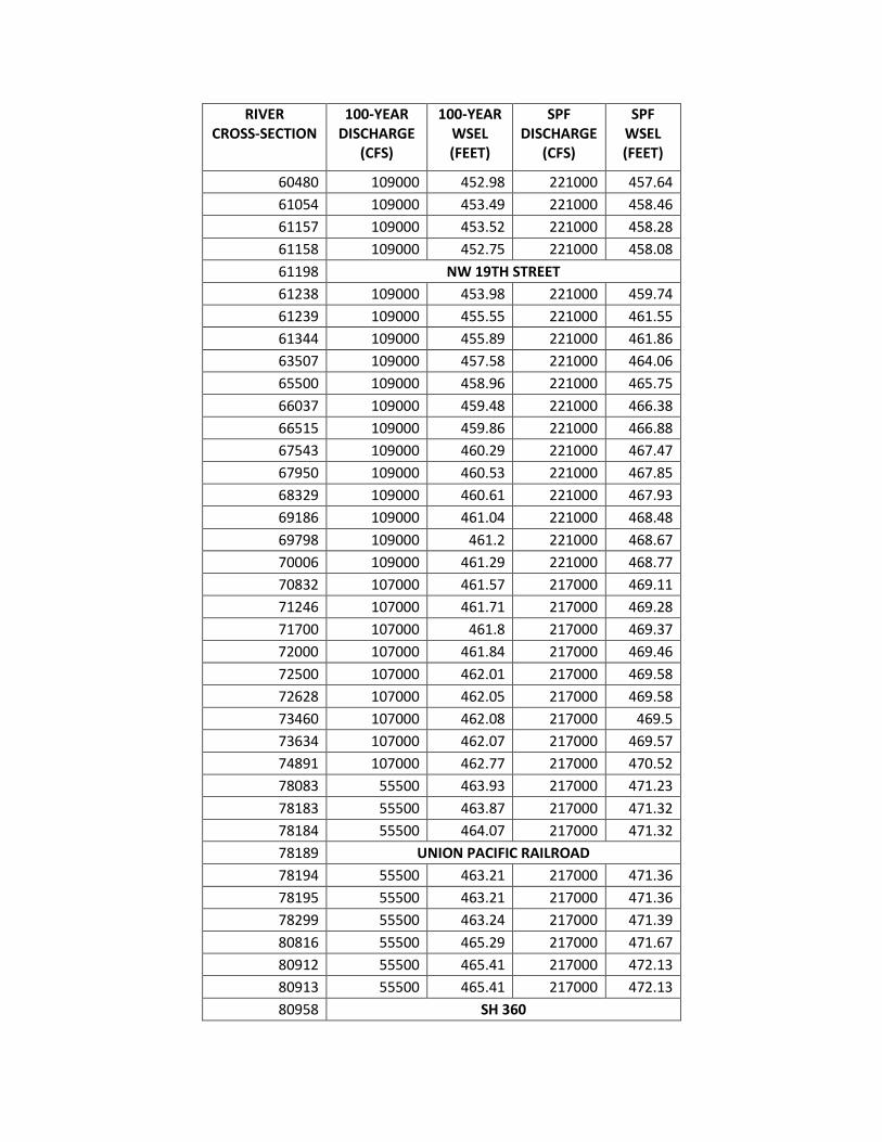
RIVER CROSS-SECTION
100-YEAR DISCHARGE
(CFS)
100-YEAR WSEL (FEET)
SPF DISCHARGE
(CFS)
SPF WSEL (FEET)
60480 109000 452.98 221000 457.64
61054 109000 453.49 221000 458.46
61157 109000 453.52 221000 458.28
61158 109000 452.75 221000 458.08
61198 NW 19TH STREET
61238 109000 453.98 221000 459.74
61239 109000 455.55 221000 461.55
61344 109000 455.89 221000 461.86
63507 109000 457.58 221000 464.06
65500 109000 458.96 221000 465.75
66037 109000 459.48 221000 466.38
66515 109000 459.86 221000 466.88
67543 109000 460.29 221000 467.47
67950 109000 460.53 221000 467.85
68329 109000 460.61 221000 467.93
69186 109000 461.04 221000 468.48
69798 109000 461.2 221000 468.67
70006 109000 461.29 221000 468.77
70832 107000 461.57 217000 469.11
71246 107000 461.71 217000 469.28
71700 107000 461.8 217000 469.37
72000 107000 461.84 217000 469.46
72500 107000 462.01 217000 469.58
72628 107000 462.05 217000 469.58
73460 107000 462.08 217000 469.5
73634 107000 462.07 217000 469.57
74891 107000 462.77 217000 470.52
78083 55500 463.93 217000 471.23
78183 55500 463.87 217000 471.32
78184 55500 464.07 217000 471.32
78189 UNION PACIFIC RAILROAD
78194 55500 463.21 217000 471.36
78195 55500 463.21 217000 471.36
78299 55500 463.24 217000 471.39
80816 55500 465.29 217000 471.67
80912 55500 465.41 217000 472.13
80913 55500 465.41 217000 472.13
80958 SH 360

RIVER CROSS-SECTION
100-YEAR DISCHARGE
(CFS)
100-YEAR WSEL (FEET)
SPF DISCHARGE
(CFS)
SPF WSEL (FEET)
81003 55500 465.58 217000 472.42
81004 55500 465.58 217000 472.43
81130 55500 465.75 217000 472.57
82018 55500 466.11 217000 473.04
83836 55500 466.24 217000 473.1
84548 55500 466.32 217000 473.14
85875 107000 466.5 217000 473.27
86300 107000 466.57 217000 473.34
87415 107000 466.64 217000 473.42
88045 107000 466.71 217000 473.53
88710 107000 466.83 217000 473.67
89870 107000 466.93 217000 473.79
91637 107000 467.04 217000 473.92
92680 107000 467.09 217000 474
94400 107000 467.15 217000 474.07
95765 107000 467.22 217000 474.16
96070 107000 467.25 217000 474.19
96240 107000 467.28 217000 474.24
96550 108000 467.33 219000 474.32
96955 108000 467.45 219000 474.44
97925 108000 467.59 219000 474.58
99908 108000 467.71 219000 474.7
99918 108000 467.71 219000 474.7
99980 108000 467.72 219000 474.85
99990 108000 467.72 219000 474.85
101480 108000 467.83 219000 474.97
102900 108000 467.94 219000 475.08
104010 108000 468.01 219000 475.14
104780 108000 468.05 219000 475.19
106865 108000 468.08 219000 475.21
107250 108000 468.13 219000 475.25
107775 108000 468.25 219000 475.41
108080 43500 468.25 219000 475.45
108335 43500 468.26 219000 475.5
108465 43500 468.28 219000 475.55
108570 43500 468.26 219000 475.6
108685 43500 468.39 219000 475.62
109005 43500 468.51 219000 475.65

RIVER CROSS-SECTION
100-YEAR DISCHARGE
(CFS)
100-YEAR WSEL (FEET)
SPF DISCHARGE
(CFS)
SPF WSEL (FEET)
109220 43500 468.41 219000 475.65
109385 43500 469.58 219000 475.72
109405 43500 469.6 219000 475.65
109480 FM 157
109530 43500 470.81 219000 476.94
109585 43500 471.05 219000 477.22
109695 43500 471.22 219000 477.57
110210 43500 471.6 219000 477.71
110515 43500 471.94 219000 477.86
111205 43500 472.52 219000 478.22
111210 43500 472.49 219000 478.1
111230 RIVER LEGACY PARKS PEDESTRIAN BRIDGE
111250 43500 472.56 219000 478.26
111255 43500 472.63 219000 478.46
111679 43500 472.87 219000 478.51
112574 108000 473.22 219000 478.85
116053 108000 476.12 219000 481.48
116664 109000 476.45 220000 481.88
118100 109000 477.57 220000 483.41
118369 109000 477.81 220000 483.91
118883 109000 478.27 220000 484.55
119740 109000 478.72 220000 484.95
120428 109000 479.04 220000 485.17
120930 109000 479.48 220000 485.47
121401 109000 479.75 220000 485.76
121885 109000 479.91 220000 485.98
122304 109000 480.09 220000 486.19
122578 109000 480.11 220000 486.29
122858 109000 480.12 220000 486.38
123144 109000 480.14 220000 486.47
123437 109000 480.16 220000 486.53
123744 109000 480.18 220000 486.57
124110 108000 480.22 215000 486.69
124600 108000 480.23 215000 486.81
125016 108000 480.26 215000 487.09
125286 108000 480.28 215000 487.29
125562 108000 480.31 215000 487.43
125701 108000 480.24 215000 487.45

RIVER CROSS-SECTION
100-YEAR DISCHARGE
(CFS)
100-YEAR WSEL (FEET)
SPF DISCHARGE
(CFS)
SPF WSEL (FEET)
125742 108000 480.36 215000 487.52
126020 108000 480.4 215000 487.56
126217 108000 480.43 215000 487.58
126400 108000 480.43 215000 487.64
126590 108000 480.45 215000 487.65
126600 108000 480.45 215000 487.65
127781 108000 480.53 215000 487.75
127872 108000 480.53 215000 487.76
127873 108000 480.54 215000 487.76
127880.5 TRAMMEL-DAVIS ROAD
127888 108000 480.54 215000 487.76
127889 108000 480.54 215000 487.76
127989 108000 480.54 215000 487.76
127999 108000 480.56 215000 487.78
130407 108000 480.63 215000 487.84
130918 108000 480.65 215000 487.86
131467 108000 480.71 215000 487.91
133290 108000 480.85 215000 488.03
133369 108000 480.86 215000 488.04
133370 108000 480.84 215000 488.03
133391 ARLINGTON-BEDFORD ROAD
133412 108000 480.86 215000 488.04
133413 108000 480.88 215000 488.05
133499 110000 480.89 217000 488.06
133537 110000 480.93 217000 488.1
133770 110000 480.96 217000 488.13
133780 110000 480.96 217000 488.13
136930 110000 481.08 217000 488.22
138208 110000 481.14 217000 488.3
140885 110000 481.29 217000 488.48
142669 89000 481.39 179000 488.58
144480 89000 481.45 179000 488.63
147336 89000 481.52 179000 488.71
147346 89000 481.52 179000 488.71
147404 89000 481.53 179000 488.71
147414 89000 481.53 179000 488.71
147424 89000 481.53 179000 488.72
147496 89000 481.54 179000 488.72

RIVER CROSS-SECTION
100-YEAR DISCHARGE
(CFS)
100-YEAR WSEL (FEET)
SPF DISCHARGE
(CFS)
SPF WSEL (FEET)
147512 89000 481.54 179000 488.72
148106 89000 481.6 179000 488.77
148663 89000 481.73 179000 488.86
149202 89000 481.71 179000 488.91
150374 89000 482.79 179000 489.19
151136 89000 483.4 179000 489.42
151932 89000 484.46 179000 489.96
153293 89000 485.56 179000 490.55
154301 89000 486.17 179000 491.08
154403 89000 486.27 179000 491.17
154404 89000 486.06 179000 491.1
154424 PRECINCT LINE ROAD
154444 89000 486.41 179000 491.24
154445 89000 486.64 179000 491.29
154527 89000 486.65 179000 491.31
155714 89000 487.45 179000 492.11
158061 89000 488.87 179000 493.5
158561 89000 489.44 179000 494.02
158671 89000 489.47 179000 494.08
160778 89000 490.33 179000 494.92
160878 89000 490.44 179000 495.07
161058 89000 490.63 179000 495.29
161322 89000 490.83 179000 495.55
161634 89000 491.17 179000 495.93
161734 89000 491.23 179000 496.01
162435 89000 491.56 179000 496.43
165243 91500 492.75 182000 497.87
171900 91500 495.37 182000 500.04
176313 91500 499.41 182000 503.59
177485 91500 500.49 182000 505.53
178263 91500 501.1 182000 506.47
178377 91500 501.65 182000 507.68
178428 IH 820
178479 91500 502.06 182000 508.86
178664 91500 502.12 182000 509.05
179075 91500 502.68 182000 509.94
180455 91500 502.93 182000 510.13
181265 91500 502.84 182000 509.6

RIVER CROSS-SECTION
100-YEAR DISCHARGE
(CFS)
100-YEAR WSEL (FEET)
SPF DISCHARGE
(CFS)
SPF WSEL (FEET)
181285 91500 502.69 182000 508.98
181326 HANDLEY-EDERVILLE ROAD
181367 91500 502.83 182000 509.53
181471 91500 502.89 182000 509.84
181475 91500 502.86 182000 509.79
181479 91500 502.86 182000 509.79
181521 91500 502.96 182000 510.2
182146 91500 503.29 182000 510.71
183096 91500 503.56 182000 511.12
183709 91500 503.84 182000 512.16
184495 91500 504.37 182000 512.99
184850 78000 504.94 154000 513.5
185387 78000 505.15 154000 513.69
185909 78000 505.13 154000 513.63
186691 78000 505.16 154000 513.71
186871 78000 505.11 154000 513.68
187025 78000 505.1 154000 513.71
187075 78000 505.18 154000 513.84
187076 78000 505.28 154000 513.89
187080 78000 505.29 154000 513.89
187126 78000 505.32 154000 513.98
187647 78000 505.69 154000 514.22
188241 78000 506.07 154000 514.36
189097 78000 506.26 154000 514.45
189901 78000 506.3 154000 514.46
190115 78000 506.3 154000 514.46
190275 78000 506.3 154000 514.46
190456 78000 506.31 154000 514.46
190850 78000 506.33 154000 514.47
191291 78000 506.36 154000 514.49
191625 78000 506.43 154000 514.52
192756 78000 506.6 154000 514.6
193010 78000 506.64 154000 514.62
193090 78000 506.65 154000 514.64
193150 78000 506.68 154000 514.64
193191 78000 506.68 154000 514.65
193367 78000 506.73 154000 514.67
193445 78000 506.74 154000 514.69

RIVER CROSS-SECTION
100-YEAR DISCHARGE
(CFS)
100-YEAR WSEL (FEET)
SPF DISCHARGE
(CFS)
SPF WSEL (FEET)
193550 78000 506.77 154000 514.68
193960 78000 507 154000 514.78
195089 78000 507.38 154000 515.02
195526 78000 507.67 154000 515.2
195930 78000 508.23 154000 515.46
196680 78000 508.78 154000 515.74
197450 78000 509.29 154000 516.16
197631 78000 509.32 154000 516.19
197812 78000 509.5 154000 516.32
198174 78000 509.73 154000 516.57
199000 78000 510 154000 516.91
199650 78000 510.51 154000 517.27
201380 78000 510.96 154000 517.73
203180 78000 511.38 154000 518.15
204336 78000 511.64 154000 518.35
205240 78000 512.64 154000 519.23
206218 78000 513.29 154000 519.72
206325.5 EAST 1ST STREET
206448.3 78000 513.43 154000 519.84
207998 78000 513.71 154000 520.02
208638.1 83500 513.83 165000 520.15
209098 83500 514.03 165000 520.35
209734 83500 514.35 165000 520.65
210038.7 83500 514.56 165000 520.8
210502.6 83500 514.78 165000 520.99
211182.5 83500 515.07 165000 521.25
212348.6 83500 515.33 165000 521.54
212838.3 83500 515.48 165000 521.7
213855 83500 515.92 165000 522.09
214682.5 83500 516.19 165000 522.35
215148.4 83500 516.28 165000 522.48
215842 83500 516.43 165000 522.66
216896 83500 516.85 165000 523.01
217463.3 83500 516.79 165000 522.96
217634.1 83500 516.79 165000 523.09
217695.6 BEACH STREET DAM
217720.9 83500 516.83 165000 523.09
217973.4 83500 516.88 165000 523.14

RIVER CROSS-SECTION
100-YEAR DISCHARGE
(CFS)
100-YEAR WSEL (FEET)
SPF DISCHARGE
(CFS)
SPF WSEL (FEET)
218250.3 83500 517 165000 523.13
218297 83500 516.97 165000 523.01
218330 BEACH STREET
218363 83500 517.06 165000 523.62
218392.7 83500 517.54 165000 524.53
218473.3 83500 517.93 165000 525.01
218557.3 83500 517.96 165000 525.06
218832.1 83500 517.97 165000 525.08
219217.1 83500 518.11 165000 525.25
219535.1 83500 518.26 165000 525.38
219898.8 83500 518.33 165000 525.44
220239.1 83500 518.37 165000 525.49
220501.9 83500 518.42 165000 525.53
220725.2 83500 518.4 165000 525.52
220974.4 83500 518.42 165000 525.5
221418.5 83500 518.57 165000 525.59
222113.5 68000 518.69 143000 525.62
222384.6 68000 518.64 143000 525.55
222551.6 68000 518.52 143000 525.36
222623.6 RIVERSIDE DRIVE
222651.4 68000 518.37 143000 525.42
222677.9 RIVERSIDE DRIVE
222701 68000 522.63 143000 525.88
222814.9 68000 522.52 143000 525.33
223108.4 68000 523.05 143000 527.17
223565.1 68000 523.32 143000 527.97
223743.1 68000 523.33 143000 527.95
224119.3 68000 523.49 143000 528.29
224600.2 68000 523.52 143000 528.37
225093.8 68000 523.63 143000 528.64
225352.2 68000 523.58 143000 528.47
225857.2 68000 523.6 143000 528.54
226382.3 68000 523.56 143000 528.45
226912.7 68000 523.69 143000 528.6
227430.9 68000 523.85 143000 529.07
227702.5 68000 523.79 143000 528.88
227760.9 TRINITY RAILWAY EXPRESS
227819.7 68000 523.84 143000 529.2

RIVER CROSS-SECTION
100-YEAR DISCHARGE
(CFS)
100-YEAR WSEL (FEET)
SPF DISCHARGE
(CFS)
SPF WSEL (FEET)
227866 68000 523.89 143000 529.37
228181.9 68000 524.02 143000 529.66
228422.4 68000 524.07 143000 529.77
228572.3 68000 524.12 143000 529.87
228727.1 68000 524.14 143000 529.94
228882.1 68000 524.19 143000 530.01
228942.2 68000 524.27 143000 530.14
229009.4 4TH STREET DAM
229049.2 68000 524.47 143000 530.41
229116.1 68000 524.52 143000 530.44
229159.1 4TH STREET
229200.2 68000 524.6 143000 530.78
229333.6 68000 524.66 143000 530.98
229485.7 68000 524.74 143000 531.17
229624.6 68000 524.82 143000 531.37
229811.2 68000 524.9 143000 531.57
229920.9 68000 524.95 143000 531.69
230077.8 68000 525.05 143000 531.97
230326.5 68000 525.12 143000 532.17
230452.6 68000 525.13 143000 532.2
230512.4 68000 525.14 143000 532.21
230664.8 SH 121
230758.2 68000 525.22 143000 532.48
230802.3 68000 525.33 143000 532.74
230927.7 68000 525.26 143000 532.57
230962.7 BELKNAP STREET
231008.5 68000 525.34 143000 532.98
231097.7 68000 525.33 143000 532.95
231177.9 68000 525.31 143000 532.89
231370 68000 525.4 143000 533.18
231549.6 68000 525.44 143000 533.25
231727.8 68000 525.48 143000 533.31
231852.5 68000 525.52 143000 533.39
231994.9 68000 525.6 143000 533.57
232174.5 68000 525.71 143000 533.75
232304.4 68000 525.8 143000 533.94
232437.7 68000 525.87 143000 534.09
232566.4 68000 525.94 143000 534.23

RIVER CROSS-SECTION
100-YEAR DISCHARGE
(CFS)
100-YEAR WSEL (FEET)
SPF DISCHARGE
(CFS)
SPF WSEL (FEET)
232908.1 68000 526.06 143000 534.48
233136.9 68000 526.08 143000 534.54
233353.1 68000 526.1 143000 534.58
233644.6 68000 526.14 143000 534.66
233990.2 68000 526.14 143000 534.66
234252.7 68000 526.13 143000 534.63
234484.1 71500 526.2 140000 534.88
234711.5 71500 526.33 140000 535.11
234889.2 71500 526.33 140000 535.07
234926.2 71500 526.27 140000 534.96
234990.5 IH 35E
235086.8 71500 526.36 140000 535.14
235503.9 71500 526.47 140000 535.31
235952.9 71500 526.72 140000 535.74
236201.6 71500 526.72 140000 535.73
236563.3 71500 526.69 140000 535.69
236883.8 71500 526.68 140000 535.67
237284.1 71500 526.66 140000 535.65
237501 71500 526.71 140000 535.62
237659.6 71500 526.73 140000 535.66
237903.3 71500 526.96 140000 536.06
237939.2 UNION PACIFIC RAILROAD
237987.5 71500 527.09 140000 536.5
238283.8 71500 527.15 140000 536.5
238612.5 71500 527.26 140000 536.46
238695.5 71500 527.32 140000 536.56
238773 NORTHSIDE DRIVE
238881.1 71500 527.64 140000 537.4
239025.7 71500 527.98 140000 537.91
239269.4 71500 528.08 140000 538.12
239603.9 71500 528.13 140000 538.21
239822 71500 528.19 140000 538.31
240009.9 71500 528.2 140000 538.35
240126 71500 528.21 140000 538.35
240292 71500 528.24 140000 538.39
240441 71500 528.25 140000 538.41
240614.1 71500 528.26 140000 538.44
240814 71500 528.26 140000 538.43

RIVER CROSS-SECTION
100-YEAR DISCHARGE
(CFS)
100-YEAR WSEL (FEET)
SPF DISCHARGE
(CFS)
SPF WSEL (FEET)
241026.7 71500 528.03 140000 538.21
241206.6 71500 528 140000 538.03
241224.7 71500 527.93 140000 537.92
241244.4 UNION PACIFIC RAILROAD
241264.2 71500 528.11 140000 538.64
241290.9 71500 528.17 140000 538.72
241326.1 71500 528.16 140000 538.72
241340.8 71500 528.14 140000 538.84
241352.2 BNSF RAILROAD
241363.7 71500 528.23 140000 539.57
241377.9 71500 528.25 140000 539.51
241442.8 71500 528.3 140000 539.72
241482.4 71500 528.24 140000 539.66
241498.9 BNSF RAILROAD
241515.2 71500 528.38 140000 540.21
241545.7 71500 528.49 140000 540.42
241602.9 71500 528.56 140000 540.51
241652.8 71500 528.52 140000 540.47
241732.3 SAMUELS AVENUE
241815.4 71500 529.66 140000 541.46
242030.7 69000 530.03 136000 541.89
242283.8 69000 529.86 136000 541.71
242448.8 69000 529.91 136000 541.71
242660.3 69000 529.95 136000 541.69
242883.7 69000 529.97 136000 541.63
243175.6 69000 530 136000 541.52
243416.7 69000 530.07 136000 541.51
243695.5 69000 530.14 136000 541.58
243924.9 69000 530.25 136000 541.72
244071 69000 530.27 136000 541.74
244128.4 NORTHSIDE DRIVE
244198.7 69000 530.44 136000 542.45
244479.4 69000 530.59 136000 542.61
244849.2 69000 530.67 136000 542.73
245146.9 69000 530.77 136000 542.8
245448.4 69000 531.04 136000 543.15
245772.4 69000 531.31 136000 543.52
246013.2 69000 531.47 136000 543.79

RIVER CROSS-SECTION
100-YEAR DISCHARGE
(CFS)
100-YEAR WSEL (FEET)
SPF DISCHARGE
(CFS)
SPF WSEL (FEET)
246254.2 69000 531.63 136000 544.04
246365.1 69000 531.62 136000 544.04
246476.7 69000 531.55 136000 544.01
246509 TRWD DAM
246535.4 69000 531.55 136000 544.05
246637.1 69000 531.69 136000 544.1
246949.8 69000 531.68 136000 544.03
247316.2 69000 531.77 136000 543.95
247429.1 69000 531.85 136000 544.05
247743 69000 532.01 136000 544.31
248160 69000 532.38 136000 544.58
248479.3 69500 532.46 136000 544.65
248847.2 69500 532.63 136000 544.82
249342.9 69500 532.79 136000 544.94
249738.4 69500 533.16 136000 545.22
249983.8 69500 533.2 136000 545.22
250182.7 69500 533.3 136000 545.3
250468.9 69500 533.32 136000 545.39
250673.4 69500 533.41 136000 545.46
250884 69500 533.42 136000 545.44
251047 69500 533.51 136000 545.48
251180.3 69500 534.12 136000 546.04
251357 69500 533.92 136000 545.79
251377 69500 533.91 136000 545.76
251405 NUTT DAM
251430.2 69500 534.71 136000 546.02
251480.3 69500 534.71 136000 546.01
251524.5 69500 534.76 136000 546
251835.9 69500 535.19 136000 546.04
252042.2 69500 535.41 136000 546.14
252212.3 69500 535.92 136000 546.42
252401.1 69500 536.16 136000 546.51
252502.1 69500 536.19 136000 546.42
252580.2 69500 536.36 136000 546.48
252638.8 NORTH MAIN STREET
252706.3 69500 537.79 136000 549.32
252774.7 69500 537.57 136000 549.1
252918.1 69500 538.27 136000 549.63

RIVER CROSS-SECTION
100-YEAR DISCHARGE
(CFS)
100-YEAR WSEL (FEET)
SPF DISCHARGE
(CFS)
SPF WSEL (FEET)
253189.2 69500 538.64 136000 549.91
253345.2 69500 539.05 136000 550.4
253395.2 69500 539.06 136000 550.48
253483.7 69500 539.02 136000 550.63
253562.6 69500 539.37 136000 551.28
253579 PEDESTRIAN BRIDGE
253592 69500 539.89 136000 551.67
253818.1 69500 540.7 136000 552.67
254485.9 35000 541.51 63500 553.47
254801.4 35000 541.41 63500 553.37
254928.7 35000 541.41 63500 553.36
255118.2 35000 541.48 63500 553.39
255356 35000 541.53 63500 553.41
255546.4 35000 541.6 63500 553.47
255754.9 35000 541.61 63500 553.49
256039.3 35000 541.66 63500 553.55
256299.8 35000 541.7 63500 553.59
256553.1 35000 541.79 63500 553.68
256709.4 35000 541.74 63500 553.66
256886.7 35000 541.75 63500 553.68
256910.3 TARANTULA RAILROAD
256928.4 35000 541.98 63500 554.06
257056.1 35000 542.14 63500 554.15
257269.8 35000 542.32 63500 554.31
257418.7 35000 542.4 63500 554.4
257641.7 35000 542.43 63500 554.44
257849.1 35000 542.4 63500 554.42
258064.6 35000 542.39 63500 554.39
258288 35000 542.41 63500 554.4
258568.1 35000 542.43 63500 554.35
258790 35000 542.35 63500 554.22
258860.7 HENDERSON STREET
258937.5 35000 542.51 63500 554.45
259346.8 35000 542.87 63500 554.93
259744.4 35000 542.96 63500 555.05
260033.1 35000 543 63500 555.09
260354.8 35000 543.03 63500 555.12
260762.5 35000 543.07 63500 555.16

RIVER CROSS-SECTION
100-YEAR DISCHARGE
(CFS)
100-YEAR WSEL (FEET)
SPF DISCHARGE
(CFS)
SPF WSEL (FEET)
261066.5 35000 543.11 63500 555.19
261463.5 35000 543.1 63500 555.2
261842.7 35000 543.05 63500 555.21
261868 35000 542.94 63500 555.19
261919 UNIVERSITY DRIVE
261970 35000 543.5 63500 555.36
262054.6 35000 543.89 63500 555.43
262516 35000 543.92 63500 555.45
262763.9 35000 543.94 63500 555.46
263294.3 35000 543.97 63500 555.47
263532.6 35000 543.99 63500 555.48
264027.4 35000 544.01 63500 555.49
264584.8 35000 544.05 63500 555.5
265433 35000 544.07 63500 555.51
266072.5 35000 544.09 63500 555.5
266445.2 35000 544.07 63500 555.47
266841.7 35000 544.18 63500 555.49
267052.2 35000 544.3 63500 555.52
267563.7 35000 544.36 63500 555.63
268148 35000 544.52 63500 555.77
268509.5 35000 544.58 63500 555.81
268923.7 35000 544.63 63500 555.82
269150.5 35000 544.92 63500 555.98
269446.7 35000 544.87 63500 555.94
269610.6 35000 544.78 63500 555.9
269705.5 35000 544.85 63500 555.94
269944.1 35000 545.1 63500 556.08
270252.7 35000 545.25 63500 556.11
270564.2 35000 545.24 63500 556.06
270900.4 35000 545.27 63500 556.06
271269.5 35000 545.4 63500 556.14
271634 35000 545.62 63500 556.29
271952 35000 545.65 63500 556.33
272202.9 35000 545.51 63500 556.25
272525.4 35000 545.58 63500 556.29
272836.8 35000 545.83 63500 556.4
273187.6 35000 545.89 63500 556.43
273513.4 35000 546.19 63500 556.75

RIVER CROSS-SECTION
100-YEAR DISCHARGE
(CFS)
100-YEAR WSEL (FEET)
SPF DISCHARGE
(CFS)
SPF WSEL (FEET)
273814.8 35000 546.65 63500 557.09
273967.4 35000 546.74 63500 557.14
274144 35000 546.57 63500 557.02
274149 35000 546.57 63500 557.01
274191 35000 546.57 63500 557
274196 35000 546.63 63500 557.15
274342.7 35000 546.63 63500 557.06
274899.6 35000 546.54 63500 556.75
275282.5 35000 546.96 63500 557.06
275620.4 35000 547.1 63500 557.17
275747.2 35000 547.26 63500 557.34
275942.7 35000 547.34 63500 557.54
276052.6 35000 547.42 63500 557.65
276125.9 35000 547.41 63500 557.56
276195.9 WHITE SETTLEMENT ROAD
276265.7 35000 547.65 63500 557.86
276412.8 35000 547.91 63500 558.17
276753.4 35000 548.1 63500 558.35
277135.4 35000 548.26 63500 558.44
277497.7 35000 548.39 63500 558.52
277760.9 35000 548.48 63500 558.59
277944.9 35000 548.55 63500 558.7
278151.2 35000 548.59 63500 558.75
278250.3 35000 548.62 63500 558.73
278390.9 35000 548.67 63500 558.78
278631.3 35000 548.82 63500 558.84
278899.3 35000 548.87 63500 558.79
279230.9 35000 549 63500 558.88
279408.3 35000 549.21 63500 559.12
279595 35000 549.26 63500 559.16
279856.3 35000 549.39 63500 559.3
280166.3 35000 549.5 63500 559.36
280473 35000 549.65 63500 559.49
280738.3 35000 549.82 63500 559.67
280947.3 35000 550.1 63500 560
281071.7 35000 550.15 63500 560.12
281137.8 35000 550.26 63500 560.28
281157.9 35000 550.3 63500 560.32

RIVER CROSS-SECTION
100-YEAR DISCHARGE
(CFS)
100-YEAR WSEL (FEET)
SPF DISCHARGE
(CFS)
SPF WSEL (FEET)
281181.7 TUCKER DAM
281195.4 35000 550.42 63500 560.5
281245.5 35000 550.69 63500 560.75
281464.6 35000 550.3 63500 560.2
281636.1 35000 550.36 63500 560.24
281978.7 35000 550.56 63500 560.41
282303.7 35000 550.8 63500 560.6
282606.7 35000 550.98 63500 560.76
282880.9 35000 551.18 63500 561.01
283241 35000 551.35 63500 561.16
283616.7 35000 551.64 63500 561.44
283999 35000 551.86 63500 561.63
284318.9 35000 551.99 63500 561.75
284588.4 35000 552.07 63500 561.8
284840.9 35000 552.18 63500 561.9
285118.3 35000 552.29 63500 562.01
285337.4 35000 552.4 63500 562.11
285518.5 35000 552.51 63500 562.21
285705.9 35000 552.61 63500 562.3
285891.3 35000 552.68 63500 562.36
286083.7 35000 552.77 63500 562.42
286142.2 35000 552.79 63500 562.41
286214.2 WHITE SETTLEMENT ROAD
286287.5 35000 553.06 63500 562.8
286475.7 35000 553.23 63500 563.13
286668.6 35000 553.29 63500 563.21
286821.8 35000 553.34 63500 563.25
286999.9 35000 553.49 63500 563.4
287193.9 35000 553.64 63500 563.48
287409.2 35000 553.69 63500 563.47
287782.6 35000 553.93 63500 563.63
288151.3 35000 554.06 63500 563.75
288337.2 35000 554.16 63500 563.83
288551.7 35000 554.11 63500 563.74
288633.7 SH 183/RIVER OAKS
288719.8 35000 554.57 63500 564.48
288732.5 35000 554.51 63500 564.4
288781.5 35000 554.54 63500 564.43

RIVER CROSS-SECTION
100-YEAR DISCHARGE
(CFS)
100-YEAR WSEL (FEET)
SPF DISCHARGE
(CFS)
SPF WSEL (FEET)
288788.5 CHANNEL DAM
288795.5 35000 554.89 63500 564.84
288832.5 35000 554.92 63500 564.86
289624.5 35000 555.47 63500 565.26
290635.5 35000 556.18 56500 566.39
291187.5 35000 556.53 56500 566.34
292064.5 35000 557.12 56500 566.79
292852.5 35000 557.86 56500 567.48
292953.5 35000 557.79 56500 567.34
292974.5 CARSWELL ACCESS
292995.5 35000 557.92 56500 567.43
293097.5 35000 558.33 56500 567.93
293564.5 35000 558.61 56500 567.93
294548.5 35000 559.06 56500 568.11
295478.5 35000 559.71 56500 568.66
296345.5 35000 560.26 56500 568.89
296460.5 35000 560.49 56500 568.93
296479.5 MEANDERING ROAD
296499.5 35000 560.58 56500 569.03
296618.5 35000 560.62 56500 569.16
297175.5 35000 560.93 56500 569.76
297551.5 35000 561.06 56500 569.84
297601.5 35000 561.09 56500 569.85
297607.5 CHANNEL DAM
297613.5 35000 561.1 56500 569.92
297653.5 35000 561.29 56500 570.1
297998.5 35000 562.26 56500 570.28
298842.5 35000 563.45 56500 570.8
298892.5 35000 563.52 56500 570.82
298895 CHANNEL DAM
298899.5 35000 563.67 56500 570.88
298943.5 35000 563.72 56500 570.9
299631.5 35000 564.46 56500 571.19
300530.5 35000 565.78 56500 571.75
301394.5 35000 566.48 56500 572.22
302774.5 35000 567.46 56500 572.78
303510.5 35000 567.93 56500 573.1
303612.5 35000 567.73 56500 572.96

RIVER CROSS-SECTION
100-YEAR DISCHARGE
(CFS)
100-YEAR WSEL (FEET)
SPF DISCHARGE
(CFS)
SPF WSEL (FEET)
304609.5 35000 568.8 56500 574.04
305599.5 35000 569.16 56500 574.49
RIVER CROSS-
SECTION
100-YEAR DISCHARGE
(CFS)
100-YEAR WSEL (FEET)
SPF DISCHARGE
(CFS)
SPF WSEL (FEET)
SPLIT FLOW AREA LOWER WEST FORK
34268 14500 438.53 N/A N/A
35205 14500 438.53 N/A N/A
37015 14500 438.56 N/A N/A
37145 14500 438.57 N/A N/A
37160 14500 438.57 N/A N/A
37170 LONE STAR ROAD
37200 14500 438.58 N/A N/A
37205 14500 438.58 N/A N/A
37566 14500 438.57
37716 HUNTER-FERRELL ROAD
37866 14500 438.59 N/A N/A
38059 14500 438.63 N/A N/A
41697 14500 438.66 N/A N/A
42373 N/A N/A N/A N/A
42751 14500 438.69 N/A N/A
42961 14500 438.72 N/A N/A
43369 14500 438.95 N/A N/A
43919 14500 439.77 N/A N/A
44153 14500 440.77 N/A N/A
44232 14500 443.39 N/A N/A
44291.5 BELT LINE ROAD
44351 14500 445.07 N/A N/A
44427 14500 445.24 N/A N/A
46329 14500 445.91 N/A N/A
49477 14500 446.01 N/A N/A
50225 14500 446.11 N/A N/A
51481 14500 446.19 N/A N/A
52592 14500 446.23 N/A N/A
53730 14500 446.27 N/A N/A
53930 14500 446.3 N/A N/A

RIVER CROSS-
SECTION
100-YEAR DISCHARGE
(CFS)
100-YEAR WSEL (FEET)
SPF DISCHARGE
(CFS)
SPF WSEL (FEET)
54255 14500 446.44 N/A N/A
54330 HARDROCK ROAD
54405 14500 448.78 N/A N/A
SPLIT FLOW AREA MIDDLE WEST FORK
78084 51500 463.06 N/A N/A
78185 51500 463.28 N/A N/A
78186 51500 463.28 N/A N/A
78189 UNION PACIFIC RAILROAD
78196 51500 463.43 N/A N/A
78197 51500 463.43 N/A N/A
78300 51500 463.46 N/A N/A
80817 51500 463.69 N/A N/A
80914 51500 463.49 N/A N/A
80915 51500 463.49 N/A N/A
80958 SH 360 RELIEF BRIDGE
81005 51500 464.38 N/A N/A
81006 51500 464.39 N/A N/A
81131 51500 465.53 N/A N/A
82019 51500 466.07 N/A N/A
83837 51500 466.19 N/A N/A
84549 51500 466.25 N/A N/A
SPLIT FLOW AREA UPPER WEST FORK
108081 64500 468.28 N/A N/A
108336 64500 468.3 N/A N/A
108466 64500 468.32 N/A N/A
108571 64500 468.33 N/A N/A
108686 64500 468.33 N/A N/A
109221 64500 468.32 N/A N/A
109386 64500 468.38 N/A N/A
108081 64500 468.28 N/A N/A
108336 64500 468.3 N/A N/A
108466 64500 468.32 N/A N/A
108571 64500 468.33 N/A N/A
108686 64500 468.33 N/A N/A
109221 64500 468.32 N/A N/A

RIVER CROSS-
SECTION
100-YEAR DISCHARGE
(CFS)
100-YEAR WSEL (FEET)
SPF DISCHARGE
(CFS)
SPF WSEL (FEET)
109386 64500 468.38 N/A N/A
109406 64500 468.39 N/A N/A
109480 FM 157 RELIEF BRIDGE
109531 64500 469.43 N/A N/A
109586 64500 469.49 N/A N/A
109696 64500 469.9 N/A N/A
110211 64500 469.7 N/A N/A
110516 64500 470.96 N/A N/A
111680 64500 472.69 N/A N/A
NOTE: SPLIT FLOW FOR 100-YEAR DISCHARGES ONLY

Corridor Development Certificate Manual 4th Edition
This page intentionally left blank.

APPENDIX B.2
TABLE 2-B CLEAR FORK TRINITY RIVER
100-YEAR / SPF DISCHARGE AND WATER SURFACE ELEVATIONS 2055 FUTURE CONDITIONS
MODEL APPROVED AUGUST 2013
RIVER CROSS-SECTION
100-YEAR DISCHARGE
(CFS)
100-YEAR WSEL (FEET)
SPF DISCHARGE
(CFS)
SPF WSEL (FEET)
0 CLEAR FORK/WEST FORK CONFLUENCE
473.31 48500 541.16 93000 553.25
482.9306 PEDESTRIAN BRIDGE
501.6482 48500 541.22 93000 553.38
670.0113 48500 541.22 93000 553.34
811.3182 48500 541.2 93000 553.31
1034.324 48500 541.31 93000 553.38
1266.415 48500 541.58 93000 553.5
1396.939 48500 541.55 93000 553.53
1463.029 HENDERSON STREET
1537.796 48500 541.82 93000 554.22
1765.998 48500 542.05 93000 554.34
1984.189 48500 542.13 93000 554.36
2196.683 48500 542.31 93000 554.48
2412.767 48500 542.66 93000 554.76
2556.313 48500 542.95 93000 554.92
2689.521 48500 543.03 93000 555.01
3113.178 48500 543.47 93000 555.18
3405.202 48500 543.4 93000 555.1
3628.557 48500 543.51 93000 555.13
3940.902 48500 543.62 93000 555.22
4042.46 48500 543.66 93000 555.21
4191.802 48500 543.69 93000 555.25
4346.114 48500 543.67 93000 555.27
4397.276 7TH STREET
4460.321 48500 543.78 93000 555.35
4701.715 48500 543.81 93000 555.33
4920.554 48500 543.72 93000 555.13
5037.092 48500 543.93 93000 555.24
5284.416 48500 544.35 93000 555.59
5422.282 48500 544.47 93000 555.68

RIVER CROSS-SECTION
100-YEAR DISCHARGE
(CFS)
100-YEAR WSEL (FEET)
SPF DISCHARGE
(CFS)
SPF WSEL (FEET)
5622.383 48500 544.87 93000 556.1
5799.004 48500 545.16 93000 556.28
5925.721 48500 545.26 93000 556.37
6085.75 48500 545.38 93000 556.5
6128.55 LANCASTER AVENUE
6172.783 48500 545.43 93000 556.54
6273 48500 545.49 93000 556.56
6321 48500 545.5 93000 556.56
6422 48500 545.52 93000 556.57
6431 TILLEY PEDESTRIAN BRIDGE
6440 48500 545.56 93000 556.6
6482.044 48500 545.55 93000 556.58
6650.128 48500 545.48 93000 556.54
6755.375 48500 545.42 93000 556.51
6772.202 CHANNEL DAM
6795.375 48500 545.42 93000 556.55
6996.185 48500 545.5 93000 556.55
7194.381 48500 545.53 93000 556.54
7791.853 48500 546.03 93000 556.73
8167.88 48500 546.32 93000 556.79
8180.994 BNSF RAILROAD
8192.064 48500 546.9 93000 558.41
8204.815 48500 546.94 93000 558.56
8224.763 CHANNEL DAM
8244.969 48500 546.94 93000 558.66
8334.659 48500 547.46 93000 558.74
8482.235 50000 547.5 94500 558.76
8679.124 50000 548 94500 559.03
8852.849 50000 548.18 94500 559.24
9127.056 50000 548.4 94500 559.37
9296.469 50000 548.56 94500 559.41
9489.013 50000 548.74 94500 559.49
9539.207 50000 548.68 94500 559.52
9557.631 CHANNEL DAM
9579.344 50000 548.69 94500 559.56
9629.433 50000 548.99 94500 559.56
9801.369 50000 549.07 94500 559.61
10214.95 50000 549.25 94500 559.7

RIVER CROSS-SECTION
100-YEAR DISCHARGE
(CFS)
100-YEAR WSEL (FEET)
SPF DISCHARGE
(CFS)
SPF WSEL (FEET)
10698.88 50000 549.53 94500 559.83
10926.89 50000 549.59 94500 559.87
10946.4 CHANNEL DAM
10966.91 50000 549.59 94500 559.87
11035.45 50000 550.14 94500 559.99
11428.19 50000 550.13 94500 559.98
11657.13 50000 550.57 94500 560.04
11768.63 50000 550.62 94500 560
11968.02 50000 550.76 94500 560.34
12010.59 50000 551.11 94500 560.13
12079 IH 30
12145.68 50000 551.32 94500 560.35
12195.16 50000 551.41 94500 560.3
12228.18 50000 551.34 94500 560.34
12244.75 50000 551.27 94500 560.24
12278.97 VICKERY BOULEVARD
12303.75 50000 551.74 94500 560.44
12348 50000 551.88 94500 560.71
12458 SH 121/SOUTHWEST PKWY
12568.12 50000 552.01 94500 561.07
12615.75 CITY DAM NO. 2
12617.75 50000 553.88 94500 561.52
12625.52 50000 553.88 94500 561.52
12643.73 50000 553.82 94500 561.38
12650.65 50000 553.78 94500 561.24
12692 UNION PACIFIC RAILROAD
12733.65 50000 554.2 94500 561.82
12760.85 50000 554.07 94500 563.69
12822.55 ROSEDALE STREET
12901.55 USGS CLEAR FORK GAGE
12901.55 50000 554.79 94500 563.88
13062.82 50000 554.46 94500 563.85
13253.36 50000 555.15 94500 564.07
13389.58 50000 555.34 94500 564.33
13395.58 MINIATURE RAILROAD
13401.58 50000 556.33 94500 564.63
14297 50000 558.65 94500 565.38
14949 50000 558.93 94500 565.62

RIVER CROSS-SECTION
100-YEAR DISCHARGE
(CFS)
100-YEAR WSEL (FEET)
SPF DISCHARGE
(CFS)
SPF WSEL (FEET)
15442 50000 559.29 94500 565.86
15613 50000 559.18 94500 565.81
15948 50000 559.91 94500 566.16
15983.3 50000 559.91 94500 566.11
16018.6 50000 559.91 94500 566.08
16054 50000 559.91 94500 566.08
16077.5 UNIVERSITY DRIVE
16100 50000 560.08 94500 566.45
16120 50000 560.01 94500 566.4
16140 UNIVERSITY DRIVE
16161 50000 560.14 94500 566.81
16196.6 50000 560.15 94500 566.82
16232.3 50000 560.24 94500 566.88
16268 50000 560.36 94500 566.93
16314.5 50000 560.34 94500 566.9
16361 50000 560.32 94500 566.89
16407.5 50000 560.3 94500 566.87
16454 50000 560.27 94500 566.86
16500.5 50000 560.25 94500 566.85
16547 50000 560.05 94500 566.83
16596.7 50000 560.16 94500 566.94
16646.5 50000 560.26 94500 567.03
16696.2 50000 560.35 94500 567.11
16746 50000 560.42 94500 567.19
16790.4 50000 560.43 94500 567.19
16834.8 50000 560.47 94500 567.2
16879.2 50000 560.44 94500 567.17
16923.7 50000 560.44 94500 567.17
16968.1 50000 560.84 94500 567.16
17012.5 50000 560.82 94500 567.16
17057 50000 560.81 94500 567.18
17092 50000 560.89 94500 567.18
17127 50000 561.01 94500 567.2
17162 50000 561.09 94500 567.21
17183.5 ROGERS ROAD
17206 50000 561.38 94500 567.81
17254 50000 561.44 94500 567.89
17302 50000 561.52 94500 567.97

RIVER CROSS-SECTION
100-YEAR DISCHARGE
(CFS)
100-YEAR WSEL (FEET)
SPF DISCHARGE
(CFS)
SPF WSEL (FEET)
17351.3 50000 561.56 94500 568.09
17400.6 50000 561.58 94500 568.09
17450 50000 561.63 94500 568.11
17499. 50000 561.68 94500 568.13
17548.6 50000 561.73 94500 568.14
17598 50000 561.78 94500 568.16
17647.3 50000 561.84 94500 568.18
17696.6 50000 561.91 94500 568.2
17746 50000 561.96 94500 568.14
18275 50000 562.14 94500 568.25
18867 50000 562.59 94500 568.22
19645 50000 563.5 94500 569.1
20351 50000 564.26 94500 570.19
21239 50000 565.3 94500 572.05
21275.5 CHANNEL DAM
21279 50000 565.82 94500 572.62
21329 50000 565.76 94500 572.5
21844 50000 566.35 94500 573.03
22604 50000 567.38 94500 574.22
23535 50000 568.68 94500 575.79
24091 50000 569.63 94500 577.01
24191 50000 569.7 94500 577.06
24242 HULEN STREET
24293 50000 570.18 94500 577.67
24355 50000 571.6 94500 579.83
24456 50000 571.47 94500 579.49
25321 50000 572.56 94500 580.61
25371 CHANNEL DAM
25421 50000 573.11 94500 581.33
25577 50000 573.24 94500 581.46
25578 50000 573.24 94500 581.34
25618 50000 573.24 94500 581.58
25658 STONEGATE/CLEAR FORK MAIN STREET
25699 50000 573.33 94500 581.65
25738 50000 573.34 94500 581.53
25739 50000 573.34 94500 581.79
26300 50000 573.84 94500 582.24
27364 50000 575.02 94500 582.81

RIVER CROSS-SECTION
100-YEAR DISCHARGE
(CFS)
100-YEAR WSEL (FEET)
SPF DISCHARGE
(CFS)
SPF WSEL (FEET)
28689 50000 577.02 94500 584.98
29435 50000 578.11 94500 587.3
29481.5 CHANNEL DAM
29485 50000 578.72 94500 587.41
29535 50000 578.8 94500 587.5
29613 50000 578.86 94500 587.12
29634.5 CHANNEL DAM
29638 50000 579.28 94500 587.13
29663 50000 579.35 94500 587.27
30174 50000 580.61 94500 587.34
30913 50000 581.78 94500 588.66
31770 50000 583.15 94500 591.36
32371 50000 584.07 94500 592.59
32602 50000 584.38 94500 591.87
32710 SH 121/SOUTHWEST PARKWAY
32794 50000 585.06 94500 592.75
32814 50000 585.11 94500 594.35
32940 50000 585.21 94500 594.2
33577 50000 586.38 94500 594.65
34116 50000 587.32 94500 595.47
34699 50000 588.91 94500 596.75
34814 50000 588.18 94500 595.87
34830 BRYANT-IRVIN ROAD
34846 50000 588.95 94500 597.23
34878 50000 589.2 94500 598.04
34896.5 BRYANT-IRVIN ROAD
34915 50000 590.07 94500 598.82
34957 50000 591.31 94500 600.12
35012.5 CHANNEL DAM
35016 50000 591.5 94500 600.36
35076 50000 591.68 94500 600.45
35519 48500 592.17 95500 600.56
35969 48500 592.67 95500 600.81
36466 48500 593.81 95500 601.13
37449 48500 595.43 95500 601.84
38091 48500 595.94 95500 601.99
38738 48500 596.39 95500 602.49
39023 48500 597.52 95500 604.97

RIVER CROSS-SECTION
100-YEAR DISCHARGE
(CFS)
100-YEAR WSEL (FEET)
SPF DISCHARGE
(CFS)
SPF WSEL (FEET)
39055 48500 597.58 95500 605.11
39062 CITYVIEW DAM
39101 48500 601.03 95500 605.44
39380 48500 601.46 95500 605.29
39879 48500 602.43 95500 608.22
39977 48500 602.37 95500 607.95
40020.5 SH 183
40064 48500 602.64 95500 608.3
40178 48500 602.41 95500 608.34
41045 48500 606.22 95500 612.83
43324 13000 611.2 72000 615.15
44342 13000 611.22 72000 615.43
45015 13000 611.71 72000 618.51
45544 13000 612.41 72000 620.29
46175 13000 612.91 72000 621.36
46489 13000 612.91 72000 621.14
46490 13000 612.91 72000 621.14
46550 IH 20
46610 13000 613.1 72000 623.13
46611 13000 613.1 72000 623.13
46736 13000 613.22 72000 624.64
49420 13000 615.92 72000 627.76
50598 13000 617.57 72000 628.44
51599 13000 618.77 72000 628.99
52140 13000 619.24 72000 629.19
52188.5 RAWLS DAM
52192 13000 619.31 72000 629.22
52242 13000 619.32 72000 629.25
53352 13000 620.38 72000 629.87
53901 13000 621.2 72000 630.53
54806 13000 622.42 72000 631.36
57021 13000 624.64 72000 632.67
58850 13000 626.97 72000 634.03
60451 13000 630.15 72000 635.58
61472 1 630.92 1 636.3
62405 1 630.92 1 636.3
62953 1 630.92 1 636.3
64380 1 630.92 1 636.3

RIVER CROSS-SECTION
100-YEAR DISCHARGE
(CFS)
100-YEAR WSEL (FEET)
SPF DISCHARGE
(CFS)
SPF WSEL (FEET)
65344 1 630.92 1 636.3
65616 1 630.92 1 636.3

Corridor Development Certificate Manual 4th Edition
This page intentionally left blank.

APPENDIX B.2
TABLE 2-C ELM FORK TRINITY RIVER
100-YEAR / SPF DISCHARGE AND WATER SURFACE ELEVATIONS 2055 FUTURE CONDITIONS
MODEL APPROVED AUGUST 2013
RIVER CROSS-SECTION
100-YEAR DISCHARGE
(CFS)
100-YEAR WSEL (FEET)
SPF DISCHARGE
(CFS)
SPF WSEL (FEET)
0 ELM FORK/WEST FORK CONFLUENCE
3013 44500 424.65 94000 437.42
3118 44500 424.68 94000 437.45
3119 44500 424.68 94000 437.45
3154 SHADY GROVE ROAD
3190 44500 424.7 94000 437.48
3295 44500 424.72 94000 437.49
4076 44500 424.8 94000 437.55
4653 44500 424.81 94000 437.56
4759 44500 424.82 94000 437.57
4760 44500 424.81 94000 437.56
4792.5 SH 356/IRVING BOULEVARD
4826 44500 424.83 94000 437.63
4925 44500 424.85 94000 437.64
5438 44500 424.88 94000 437.67
5965 44500 424.91 94000 437.7
6563 44500 424.94 94000 437.72
6643 44500 424.95 94000 437.73
6653 BNSF RAILROAD
6663 44500 424.96 94000 437.73
6667 44500 424.96 94000 437.73
6668 44500 424.96 94000 437.73
6678 BNSF RAILROAD
6689 44500 424.98 94000 437.74
6783 44500 425 94000 437.75
7355 44500 425.11 94000 437.85
7829 44500 425.15 94000 437.88
8599 44500 425.23 94000 437.91
9594 44500 425.39 94000 438.01
10532 44500 425.48 94000 438.07
11576 44500 425.59 94000 438.16

RIVER CROSS-SECTION
100-YEAR DISCHARGE
(CFS)
100-YEAR WSEL (FEET)
SPF DISCHARGE
(CFS)
SPF WSEL (FEET)
12658 44500 425.65 94000 438.22
13293 45500 425.68 94000 438.25
13842 45500 425.75 94000 438.3
13940 45500 425.76 94000 438.31
13941 45500 425.77 94000 438.33
13961 45500 425.77 94000 438.33
13962 45500 425.76 94000 438.31
14062 45500 425.77 94000 438.33
14317 45500 425.78 94000 438.34
14411 45500 425.78 94000 438.34
14478 SH 183/JOHN W. CARPENTER FREEWAY
14544 45500 425.8 94000 438.35
14545 45500 425.84 94000 438.38
14648 45500 425.84 94000 438.38
15678 45500 425.94 94000 438.46
16649 45500 426.01 94000 438.51
17615 45500 426.08 94000 438.6
18521 45500 426.11 94000 438.63
18570 45500 426.12 94000 438.59
18571 45500 426.1 94000 438.55
18571 FRASIER DAM
18576 45500 426.1 94000 438.55
18577 45500 426.14 94000 438.62
18621 45500 426.14 94000 438.62
19477 44500 426.19 92000 438.66
20480 44500 426.31 92000 438.76
21333 44500 426.37 92000 438.79
22356 45000 426.42 92000 438.81
22456 45000 426.42 92000 438.76
22457 45000 426.48 92000 438.84
22501 SH 482/STORY LANE
22546 45000 426.51 92000 438.93
22610 45000 426.48 92000 438.93
22630 DART RAIL LINE
22649 45000 426.5 92000 438.94
23574 45000 426.69 92000 439.02
24534 45000 426.78 91000 439.06
24900 45000 426.79 91000 439.07

RIVER CROSS-SECTION
100-YEAR DISCHARGE
(CFS)
100-YEAR WSEL (FEET)
SPF DISCHARGE
(CFS)
SPF WSEL (FEET)
25248 45000 426.83 91000 439.08
26342 45000 426.89 91000 439.1
27249 45000 426.96 91000 439.12
28109 45000 427.02 91000 439.15
28770 45000 427.22 91000 439.19
29170 45000 427.43 91000 439.21
29319 45000 427.59 91000 439.22
29320 45000 427.58 91000 439.24
29378.5 LOOP 12/WALTON WALKER BOULEVARD
29438 45000 427.64 91000 439.32
29539 45000 427.67 91000 439.35
30755 45000 427.78 91000 439.4
31605 48000 427.86 92000 439.43
31880 38200 427.93 92000 439.43
32748 38200 427.98 92000 439.46
33960 38200 428.07 92000 439.49
34078 38200 428.2 92000 439.5
34178 38200 428.14 92000 439.5
34179 38200 428.27 92000 439.52
34191.5 WILDWOOD DRIVE
34205 38200 428.3 92000 439.53
34320 38200 428.32 92000 439.52
34430 38200 428.34 92000 439.53
35400 38200 428.38 92000 439.55
36107 38200 428.33 92000 439.53
37169 38200 428.71 92000 439.69
37297 38200 428.73 92000 439.63
37298 38200 428.98 92000 439.89
37307 BURLINGTON NORTHERN RAILROAD
37317 38200 429.03 92000 439.91
37450 38200 429.1 92000 439.92
39820 38200 429.25 92000 440.05
40767 38200 429.3 92000 440.08
42882 38200 429.52 92000 440.19
42984 38200 429.58 92000 440.21
43005.5 CALIFORNIA CROSSING ROAD
43026 38200 429.63 92000 440.25
43144 38200 429.62 92000 440.25

RIVER CROSS-SECTION
100-YEAR DISCHARGE
(CFS)
100-YEAR WSEL (FEET)
SPF DISCHARGE
(CFS)
SPF WSEL (FEET)
44243 38200 429.86 92000 440.36
44293 38200 429.87 92000 440.36
44294 38200 429.48 92000 440.22
44299 38200 430.02 92000 440.22
44300 38200 429.76 92000 440.45
44345 38200 430.29 92000 440.47
47791 38200 430.87 92000 440.74
48610 38200 431.01 92000 440.81
48711 38200 431.03 92000 440.82
48712 38200 431.21 92000 440.86
48756 NORTHWEST HIGHWAY
48801 38200 431.41 92000 440.9
48911 38200 431.42 92000 440.9
49916 48000 431.66 92000 441.02
50753 48000 431.78 92000 441.08
51512 48000 431.82 92000 441.1
52394 48000 431.84 92000 441.1
53292 48000 431.85 92000 441.11
54233 47000 431.94 88000 441.16
54411 47000 431.97 88000 441.17
54473 47000 431.97 88000 441.17
54619 47000 431.99 88000 441.17
54763 47000 432 88000 441.17
54811 47000 432 88000 441.17
54948 47000 432.01 88000 441.18
54985 47000 432 88000 441.17
55696 47000 432.19 88000 441.2
57195 47000 432.41 88000 441.24
58046 48000 432.74 88500 441.29
58429 48000 432.84 88500 441.31
58532 48000 433.17 88500 441.18
58572 ROYAL LANE
58612 48000 433.42 88500 441.4
58654 48000 433.63 88500 441.5
59073 48000 433.92 88500 441.61
59960 48000 434.06 88500 441.65
60810 48000 434.06 88500 441.66
61203 47500 434.04 87500 441.64

RIVER CROSS-SECTION
100-YEAR DISCHARGE
(CFS)
100-YEAR WSEL (FEET)
SPF DISCHARGE
(CFS)
SPF WSEL (FEET)
62351 47500 434.17 87500 441.73
63381 47500 434.2 87500 441.77
64104 47500 434.15 87500 441.8
64195 47500 434.29 87500 441.84
64196 47500 434.29 87500 441.84
64240 IH 635 EB/LBJ FREEWAY EB
64285 47500 434.43 87500 441.91
64405 47500 434.54 87500 441.97
64406 47500 434.54 87500 441.97
64450 IH 635 WB/LBJ FREEWAY WB
64495 47500 434.66 87500 442.04
64617 47500 434.6 87500 442.01
65313 47500 435.24 87500 442.35
66159 47500 435.78 87500 442.61
67169 47500 436.21 87500 442.89
67264 47500 435.85 87500 442.69
67265 47500 435.85 87500 442.69
67314 VALLEY VIEW LANE
67364 47500 436.14 87500 443.5
67474 47500 436.54 86000 443.7
67614 47500 436.83 86000 443.9
68705 47500 437.3 86000 444.22
69701 47500 437.56 86000 444.42
70593 47000 437.63 85500 444.5
71682 47000 437.83 85500 444.63
72713 47500 437.99 85500 444.74
76475 47000 438.33 85000 444.95
78187 47000 438.47 85000 445.06
80579 47000 438.63 85000 445.19
81848 45500 438.99 82500 445.39
82762 45500 439.31 82500 445.53
83530 45500 439.57 82500 445.66
84436 48000 439.82 82000 445.77
84959 48000 440.04 82000 445.85
86107 48000 440.17 82000 445.91
86551 48000 440.35 82000 446.01
86793 48000 440.34 82000 446.01
87191 48000 440.38 82000 446.07

RIVER CROSS-SECTION
100-YEAR DISCHARGE
(CFS)
100-YEAR WSEL (FEET)
SPF DISCHARGE
(CFS)
SPF WSEL (FEET)
87338 48000 440.13 82000 445.59
87339 48000 440.19 82000 445.81
87383 BELT LINE ROAD
87428 48000 440.54 82000 446.61
87521 48000 441.01 82000 447.07
87522 48000 441.02 82000 447.07
87531 SOUTHERN PACIFIC RAILROAD
87541 48000 441.15 82000 447.12
87645 48000 441.3 82000 447.36
87965 48000 442.22 N/A N/A
88468 48000 442.51 N/A N/A
88712 48000 442.38 N/A N/A
89694 48000 443.35 N/A N/A
90532 48000 443.54 N/A N/A
91530 48000 443.75 N/A N/A
92351 48000 443.77 N/A N/A
93141 48000 443.62 N/A N/A
93190 48000 443.68 N/A N/A
93191 48000 442.7 N/A N/A
93191 USGS CARROLLTON GAGE
93196 48000 442.76 N/A N/A
93197 48000 444.25 N/A N/A
93212 48000 444.22 N/A N/A
93254.5 SANDY LAKE ROAD
93297 48000 444.2 N/A N/A
93359 48000 444.44 N/A N/A
93940 48000 445.45 N/A N/A
97178 49500 447.63 N/A N/A
97919 49500 447.96 87000 449.67
98884 49500 448.21 87000 450.07
99708 49500 448.38 87000 450.36
101428 49500 448.52 87000 450.52
102686 49500 448.59 87000 450.6
104700 30500 448.75 66600 450.81
104750 30500 448.77 66600 451.3
105167 30500 448.85 66600 451.4
105600 30500 449.03 66600 451.61
105936 30500 449.14 66600 451.74

RIVER CROSS-SECTION
100-YEAR DISCHARGE
(CFS)
100-YEAR WSEL (FEET)
SPF DISCHARGE
(CFS)
SPF WSEL (FEET)
106657 30500 449.3 66600 451.94
106700 30500 449.33 66600 451.97
107820 30500 449.52 66600 452.2
107964 30500 449.53 66600 452.23
109152 30500 449.64 66600 452.36
109304 30500 449.67 66600 452.41
109445 30500 449.68 66600 452.43
109670 30500 449.71 66600 452.47
110074 30500 449.93 66600 452.9
110174 30500 449.96 66600 452.9
110194 IH 35E ACCESS ROAD
110214 30500 450.1 66600 453.21
110261 30500 450.24 66600 453.53
110323 IH 35E/STEMMONS FREEWAY
110385 30500 450.58 66600 454.3
110435 30500 450.56 66600 454.28
110455 IH 35E ACCESS ROAD
110475 30500 450.74 66600 454.62
110572 30500 451.13 66600 455.24
111934 21000 451.68 66600 455.79
112494 21000 451.74 66600 455.93
112617 21000 451.74 66600 455.94
112622 UNION PACIFIC RAILROAD
112627 21000 451.75 66600 455.97
112732 21000 451.76 66600 455.98
113864 21000 451.88 66600 456.18
116381 21000 452.01 66600 456.28
118732 21000 452.17 66600 456.4
119714 21000 452.26 66600 456.49
120752 21000 452.36 66600 456.59
122844 SH 121
122934 21000 452.6 66600 457.07
123134 21000 452.65 66600 457.1
123524 21000 452.71 66600 457.15
124975 21000 452.91 66600 457.26
125658 21000 453.08 66600 457.36
126171 7100 453.3 10600 457.54
126172 7100 453.3 10600 457.54

RIVER CROSS-SECTION
100-YEAR DISCHARGE
(CFS)
100-YEAR WSEL (FEET)
SPF DISCHARGE
(CFS)
SPF WSEL (FEET)
126232 HEBRON PARKWAY
126292 7100 453.3 10600 457.55
126293 7100 453.3 10600 457.55
126818 7100 453.33 10600 457.57
126819 7100 453.33 10600 457.57
127374 7100 453.36 10600 457.59
127686 7100 453.4 10600 457.62
128259 7100 453.44 10600 457.65
129048 7100 453.59 10600 457.67
129689 7100 453.65 10600 457.7
130377 7100 453.82 10600 457.74
130977 7100 453.97 10600 457.76
131532 7100 454.26 10600 457.97
131998 7100 454.42 10600 458.12
132656 7100 454.58 10600 458.3
133634 7100 454.75 10600 458.43
134538 7100 454.89 10600 458.57
135370 7100 455.13 10600 458.72
136149 7100 455.42 10600 458.99
137352 7100 455.79 10600 459.33
137878 7100 455.88 10600 459.41
138514 7100 456.03 10600 459.62
139643 21000 456.21 66600 459.69
139890 21000 456.22 66600 459.69
141084 21000 456.22 66600 459.71
141274 21000 456.22 66600 459.73
141518 21000 456.23 66600 459.77
141891 21000 456.3 66600 459.9
142702 21000 456.31 66600 459.95
142900 21000 455.38 66600 459.97
143265 21000 456.91 66600 460
143756 21000 456.91 66600 460.02
144148 21000 456.91 66600 460.01
144314 21000 456.92 66600 460.05
144474 21000 456.93 66600 460.12
144554 21000 456.94 66600 460.16
144676 21000 456.96 66600 460.25
144901 21000 457 66600 460.4

RIVER CROSS-SECTION
100-YEAR DISCHARGE
(CFS)
100-YEAR WSEL (FEET)
SPF DISCHARGE
(CFS)
SPF WSEL (FEET)
145143 21000 456.98 66600 460.43
145405 21000 456.13 66600 460.26
145775 21000 458.06 66600 462.21
146190 21000 459.02 66600 462.54
146373 21000 458.41 66600 462.51
147204 21000 460.96 66600 463.99
147300 21000 461.08 66600 464.18
147301 21000 461.08 66600 464.18
147345 SH 121
147390 21000 461.34 66600 464.83
147489 21000 461.46 66600 465.1
148101 1 461.86 1 465.85
148723 1 461.86 1 465.85
149594 1 461.86 1 465.85
150592 1 461.86 1 465.85
151320 1 461.86 1 465.85
152100 1 461.86 1 465.85
153092 1 461.86 1 465.85
153191 1 461.86 1 465.85
153192 1 461.86 1 465.85
153206 ATSF RAILROAD
153221 1 461.86 1 465.85
153328 1 461.86 1 465.85
158878 LEWISVILLE DAM
RIVER CROSS-SECTION
100-YEAR DISCHARGE
(CFS)
100-YEAR WSEL (FEET)
SPF DISCHARGE
(CFS)
SPF WSEL (FEET)
SPLIT FLOW AREA MIDDLE ELM FORK
81 9800 427.75 N/A N/A
408 9800 428.23 N/A N/A
712 9800 428.41 N/A N/A
889 9800 428.58 N/A N/A
1069 9800 428.64 N/A N/A
1527 9800 428.68 N/A N/A
1693 CULVERT
1859 9800 428.74 N/A N/A

RIVER CROSS-SECTION
100-YEAR DISCHARGE
(CFS)
100-YEAR WSEL (FEET)
SPF DISCHARGE
(CFS)
SPF WSEL (FEET)
1936 9800 428.8 N/A N/A
1985.5 NORTHWEST HIGHWAY
2035 9800 428.81 N/A N/A
2241 9800 428.8 N/A N/A
2443 9800 428.82 N/A N/A
2478.5 LOMBARDY LANE
2514 9800 428.82 N/A N/A
2906 9800 428.65 N/A N/A
3188 9800 428.81 N/A N/A
3525 9800 429.23 N/A N/A
3806 9800 429.36 N/A N/A
4071 9800 429.5 N/A N/A
4345 9800 430.18 N/A N/A
4677 9800 430.33 N/A N/A
5127 9800 430.51 N/A N/A
5841 9800 430.61 N/A N/A
6108 9800 430.65 N/A N/A
6448 9800 430.69 N/A N/A
6925 9800 430.79 N/A N/A
7360 9800 430.83 N/A N/A
7639 9800 430.86 N/A N/A
7856 9800 430.9 N/A N/A
8084 9800 430.92 N/A N/A
8217 9800 430.95 N/A N/A
8255 SPANGLER ROAD
8293 9800 430.96 N/A N/A
8419 9800 430.96 N/A N/A
8594 9800 431.04 N/A N/A
8953 9800 431.1 N/A N/A
9089 9800 430.9 N/A N/A
9100 BURLINGTON NORTHERN RAILROAD
9111 9800 431.26 N/A N/A
SPLIT FLOW AREA PGBT EAST
87000 N/A N/A 15500 448.09
88712.1 N/A N/A 15500 448.1
89694.1 N/A N/A 15500 448.27
90532.1 N/A N/A 15500 448.32
91530.1 N/A N/A 15500 448.37

RIVER CROSS-SECTION
100-YEAR DISCHARGE
(CFS)
100-YEAR WSEL (FEET)
SPF DISCHARGE
(CFS)
SPF WSEL (FEET)
92351.1 N/A N/A 15500 448.41
93141.1 N/A N/A 15500 448.48
93190.1 N/A N/A 15500 448.5
93191.1 N/A N/A 15500 448.5
93196.1 N/A N/A 15500 448.5
93197.1 N/A N/A 15500 448.5
93212.1 N/A N/A 15500 448.49
93297.1 N/A N/A 15500 448.51
93359.1 N/A N/A 15500 448.55
93940.1 N/A N/A 15500 448.62
97178.1 N/A N/A 15500 448.71
98000 N/A N/A 15500 448.85
SPLIT FLOW AREA PGBT WEST
88712 N/A N/A 66500 448.1
89694 N/A N/A 66500 448.24
90532 N/A N/A 66500 448.3
91530 N/A N/A 66500 448.37
92351 N/A N/A 66500 448.39
93141 N/A N/A 66500 448.42
93190 N/A N/A 66500 448.44
93191 N/A N/A 66500 448.35
93196 N/A N/A 66500 448.36
93197 N/A N/A 66500 448.48
93212 N/A N/A 66500 448.47
93254.5 SANDY LAKE ROAD
93297 N/A N/A 66500 448.48
93359 N/A N/A 66500 448.6
93940 N/A N/A 66500 448.8
97178 N/A N/A 66500 449.36
SPLIT FLOW UPPER AREA ELM FORK
126171 13900 453.37 56000 457.61
126172 13900 453.37 56000 457.61
126232 HEBRON PARKWAY
126292 13900 453.41 56000 457.64
126293 13900 453.41 56000 457.64
126818 13900 453.62 56000 457.68
127248 13900 453.65 56000 457.71
127678 13900 453.21 56000 457.8

RIVER CROSS-SECTION
100-YEAR DISCHARGE
(CFS)
100-YEAR WSEL (FEET)
SPF DISCHARGE
(CFS)
SPF WSEL (FEET)
128188 13900 454.03 56000 458.03
128738 13900 454.02 56000 458.08
129258 13900 454.33 56000 458.06
129848 13900 454.39 56000 458.26
130418 13900 454.64 56000 458.35
131168 13900 454.77 56000 458.69
131838 13900 454.84 56000 458.87
132538 13900 454.85 56000 459.06
132780 13900 454.66 56000 459.38
132950 13900 455.92 56000 459.5
LEWISVILLE LAKE SPILLWAY
3500 21000 465.7 66600 469.48
4420 21000 468.51 66600 471.2
5080 21000 469.64 66600 472.71
5500 21000 470 66600 473.19
5940 21000 470.58 66600 477.24
6730 21000 472.26 66600 479.7
7310 21000 473.92 66600 485.21
7380 21000 473.26 66600 484.48
8300 21000 479.74 66600 489.37
9030 21000 480.69 66600 490.45
9810 21000 482.29 66600 492.54
10510 21000 483.03 66600 493.04
11770 21000 485.66 66600 495.52
11870 21000 485.9 66600 495.52
11880 ATSF RAILROAD
11890 21000 486.08 66600 495.81
12720 21000 490.33 66600 500.31
13580 21000 500.75 66600 507.67
15010 21000 508.92 66600 518.5
15590 21000 512.7 66600 520.71

Corridor Development Certificate Manual 4th Edition
This page intentionally left blank.

APPENDIX B.2
TABLE 2-D TRINITY RIVER
100-YEAR / SPF DISCHARGE AND WATER SURFACE ELEVATIONS 2055 FUTURE CONDITIONS
MODEL APPROVED AUGUST 2013
RIVER CROSS-SECTION
100-YEAR DISCHARGE
(CFS)
100-YEAR WSEL (FEET)
SPF DISCHARGE
(CFS)
SPF WSEL (FEET)
25457 129000 392.7 300000 398.9
27415 129000 393.81 300000 400.31
29003 129000 394.12 300000 400.73
30157 129000 394.26 300000 400.92
32658 129000 394.75 300000 401.55
32748 129000 394.78 300000 401.51
32772 DOWDY-FERRY ROAD
32796 129000 394.85 300000 401.72
32870 129000 395.05 300000 402.02
35192 129000 395.64 300000 402.82
36519 129000 395.85 300000 403.13
37760 129000 395.99 300000 403.31
40250 129000 396.24 300000 403.65
42590 129000 396.54 300000 404.08
44224 129000 397.12 300000 404.91
48797 129000 398.52 300000 406.75
49913 129000 399.03 300000 407.69
50003 IH 20/IH 635
50093 129000 399.13 300000 407.89
51060 129000 399.48 300000 408.42
52016 130000 399.68 302000 408.91
53028 130000 399.71 302000 408.96
53445 130000 399.72 302000 408.98
53580 130000 399.72 302000 408.99
54014 130000 399.73 302000 409.01
55003 130000 399.75 302000 409.04
55893 130000 399.76 302000 409.07
56750 130000 399.78 302000 409.11
58584 130000 399.82 302000 409.17
59451 130000 399.85 302000 409.23
60954 130000 399.89 302000 409.29

RIVER CROSS-SECTION
100-YEAR DISCHARGE
(CFS)
100-YEAR WSEL (FEET)
SPF DISCHARGE
(CFS)
SPF WSEL (FEET)
62087 130000 399.95 302000 409.39
63971 130000 400.04 302000 409.52
66395 130000 400.29 302000 409.81
68027 130000 401.1 302000 410.71
68150 130000 401.24 302000 410.87
69100 130000 401.36 302000 410.91
69782 130000 401.47 302000 410.96
70000 130000 401.52 302000 410.99
71510 130000 401.67 302000 411.07
73020 130000 402.01 302000 411.37
74136 130000 402.44 302000 411.83
75204 130000 403 302000 412.16
75812 130000 403.31 302000 411.89
75847 130000 403.4 302000 412.01
75882 130000 403.41 302000 412.05
75926 SH 12
75970 130000 403.56 302000 412.91
76824 130000 404.44 302000 414.27
77843 130000 404.71 302000 414.47
78614 124000 404.81 284000 414.56
79352 124000 404.91 284000 414.68
80036 124000 405.02 284000 414.78
80641 124000 405.14 284000 414.87
81209 124000 405.29 284000 414.99
81790 124000 405.49 284000 415.19
82361 124000 405.68 284000 415.38
83381 129000 405.86 295000 415.58
84658 129000 405.99 295000 415.73
85916 129000 406.28 295000 416.02
87333 129000 406.6 295000 416.34
88626 129000 406.91 295000 416.69
89108 129000 406.98 295000 416.81
89527 129000 407.06 295000 416.83
89537 UNION PACIFIC RAILROAD
89547 129000 407.16 295000 417.13
89764 129000 407.32 295000 417.32
89996 129000 407.37 295000 417.37
90230 129000 407.42 295000 417.4

RIVER CROSS-SECTION
100-YEAR DISCHARGE
(CFS)
100-YEAR WSEL (FEET)
SPF DISCHARGE
(CFS)
SPF WSEL (FEET)
90458 129000 407.5 295000 417.51
90498 SH 310
90538 129000 407.81 295000 418.16
90927 129000 408.19 295000 418.59
91392 129000 408.48 295000 418.97
94735 129000 408.96 295000 419.45
95404 129000 409.24 295000 419.76
95764 129000 409.39 295000 419.92
96286 129000 409.61 295000 420.06
96333 129000 409.64 295000 420.08
96570 129000 409.71 295000 420.13
96617 129000 409.73 295000 420.15
96795 129000 409.8 295000 420.21
97043 129000 409.87 295000 420.27
97280 129000 409.94 295000 420.32
97730 129000 410.02 295000 420.38
98188 129000 410.09 295000 420.42
98653 129000 410.16 295000 420.44
99167 129000 410.34 295000 420.59
99800 129000 410.58 295000 420.8
100453 129000 410.8 295000 421.03
101138 129000 410.96 295000 421.22
101800 129000 411.16 295000 421.43
102800 129000 411.53 295000 421.88
103453 129000 411.73 295000 422.12
103493 BNSF RAILROAD
103533 129000 412.12 295000 422.59
103960 129000 412.32 295000 422.8
104446 129000 412.46 295000 422.98
104960 129000 412.61 295000 423.18
105329 129000 412.65 295000 423.27
105358 MLK BOULEVARD
105387 129000 412.77 295000 423.76
106100 129000 413.27 295000 424.2
106650 129000 413.47 295000 424.47
107130 129000 413.65 295000 424.69
107546 129000 413.78 295000 424.85
107551 129000 413.76 295000 424.84

RIVER CROSS-SECTION
100-YEAR DISCHARGE
(CFS)
100-YEAR WSEL (FEET)
SPF DISCHARGE
(CFS)
SPF WSEL (FEET)
107776 129000 413.79 295000 424.86
107781 129000 413.81 295000 424.88
107965 129000 413.83 295000 424.9
108100 129000 413.79 295000 424.81
108116 129000 413.8 295000 424.81
108128 129000 413.83 295000 424.86
108158 129000 413.83 295000 424.86
108240 129000 413.84 295000 424.86
108250 129000 413.84 295000 424.87
108270 129000 413.81 295000 424.78
108276 129000 413.82 295000 424.93
108287 ATSF RAILROAD
108298 129000 414.34 295000 425.74
108348 129000 414.5 295000 425.97
108364 DART RAIL LINE
108380 129000 414.64 295000 426.09
108457 129000 414.77 295000 426.3
108514 129000 414.82 295000 426.33
108530 129000 414.82 295000 426.32
108552 129000 414.82 295000 426.33
108688 129000 414.87 295000 426.44
108698 129000 414.86 295000 426.43
108866 129000 414.89 295000 426.47
108871 129000 414.9 295000 426.48
109035 129000 414.91 295000 426.5
109246 129000 414.92 295000 426.51
109458 129000 414.93 295000 426.5
109670 129000 414.92 295000 426.49
109882 129000 414.92 295000 426.46
109957 129000 414.92 295000 426.46
109983 CORINTH STREET
110009 129000 414.96 295000 426.6
110086 129000 414.99 295000 426.62
110214 129000 415 295000 426.62
110342 129000 415.02 295000 426.64
110470 129000 415.04 295000 426.67
110626 129000 415.06 295000 426.68
110783 129000 415.06 295000 426.67

RIVER CROSS-SECTION
100-YEAR DISCHARGE
(CFS)
100-YEAR WSEL (FEET)
SPF DISCHARGE
(CFS)
SPF WSEL (FEET)
110929 129000 415.09 295000 426.7
111076 129000 415.11 295000 426.73
111223 129000 415.11 295000 426.73
111400 129000 415.12 295000 426.74
111577 129000 415.16 295000 426.79
111754 129000 415.21 295000 426.87
111940 129000 415.27 295000 426.96
112127 129000 415.32 295000 427.05
112314 129000 415.33 295000 427.07
112473 129000 415.35 295000 427.1
112633 129000 415.37 295000 427.13
112783 129000 415.38 295000 427.15
112883 129000 415.39 295000 427.16
112933 129000 415.4 295000 427.16
113089 129000 415.41 295000 427.18
113247 129000 415.44 295000 427.21
113405 129000 415.45 295000 427.22
113563 129000 415.48 295000 427.24
113726 129000 415.52 295000 427.29
113890 129000 415.57 295000 427.35
114054 129000 415.57 295000 427.37
114116 129000 415.58 295000 427.38
114149.5 IH 35E NB
114183 129000 415.63 295000 427.65
114243 129000 415.64 295000 427.67
114457 129000 415.77 295000 427.82
114510 129000 415.78 295000 427.83
114541 IH 35E SB
114572 129000 415.81 295000 427.96
114641 129000 415.82 295000 427.96
114773 129000 415.83 295000 427.97
114905 129000 415.89 295000 428.03
115038 129000 415.92 295000 428.06
115236 129000 415.93 295000 428.08
115434 129000 415.94 295000 428.1
115633 129000 415.91 295000 428.08
115705 129000 415.92 295000 428.09
115734.5 JEFFERSON BOULEVARD

RIVER CROSS-SECTION
100-YEAR DISCHARGE
(CFS)
100-YEAR WSEL (FEET)
SPF DISCHARGE
(CFS)
SPF WSEL (FEET)
115764 129000 416.02 295000 428.26
115937 129000 416.11 295000 428.37
116111 129000 416.11 295000 428.37
116185 129000 416.13 295000 428.39
116214 HOUSTON STREET
116243 129000 416.21 295000 428.66
116314 129000 416.23 295000 428.69
116464 129000 416.32 295000 428.78
116615 129000 416.33 295000 428.8
116766 129000 416.4 295000 428.95
116942 129000 416.42 295000 428.98
117118 129000 416.46 295000 429.02
117294 129000 416.49 295000 429.06
117403 129000 416.54 295000 429.11
117572 129000 416.69 295000 429.25
117672 129000 416.7 295000 429.27
117801 129000 416.77 295000 429.35
117920 129000 416.83 295000 429.41
118000 129000 416.85 295000 429.44
118075 129000 416.87 295000 429.46
118283 129000 416.91 295000 429.51
118381 129000 416.94 295000 429.55
118533 129000 417 295000 429.61
118611 129000 417.02 295000 429.63
118657 IH 30
118703 129000 417.09 295000 429.72
118782 129000 417.12 295000 429.74
118966 129000 417.18 295000 429.81
119150 129000 417.25 295000 429.88
119334 129000 417.3 295000 429.93
119518 129000 417.33 295000 429.97
119686 129000 417.37 295000 430.01
119855 129000 417.39 295000 430.04
120023 129000 417.42 295000 430.08
120192 129000 417.43 295000 430.11
120337 129000 417.49 295000 430.15
120483 129000 417.49 295000 430.16
120629 129000 417.55 295000 430.2

RIVER CROSS-SECTION
100-YEAR DISCHARGE
(CFS)
100-YEAR WSEL (FEET)
SPF DISCHARGE
(CFS)
SPF WSEL (FEET)
120693 129000 417.59 295000 430.25
120729 COMMERCE STREET
120765 129000 417.66 295000 430.5
120831 129000 417.68 295000 430.52
121002 129000 417.73 295000 430.59
121174 129000 417.83 295000 430.68
121345 129000 417.94 295000 430.8
121517 129000 418.03 295000 430.92
121607 129000 418.04 295000 430.97
121623 UNION PACIFIC RAILROAD
121639 129000 418.13 295000 431.23
121723 129000 418.17 295000 431.25
121884 129000 418.19 295000 431.27
122045 129000 418.26 295000 431.34
122206 129000 418.29 295000 431.37
122390 129000 418.31 295000 431.4
122438 129000 418.31 295000 431.4
122500 WOODALL RODGERS FREEWAY
122562 129000 418.38 295000 431.5
122760 129000 418.46 295000 431.57
122834 129000 418.49 295000 431.61
122860 CONTINENTAL AVENUE
122886 129000 418.53 295000 431.74
122961 129000 418.55 295000 431.76
123161 129000 418.6 295000 431.81
123341 129000 418.65 295000 431.86
123441 129000 418.68 295000 431.89
123511 129000 418.69 295000 431.91
123661 129000 418.73 295000 431.95
123861 129000 418.78 295000 432.01
124052 129000 418.83 295000 432.07
124243 129000 418.87 295000 432.13
124434 129000 418.94 295000 432.21
124626 129000 419 295000 432.29
124841 129000 419.07 295000 432.37
125056 129000 419.1 295000 432.41
125272 129000 419.13 295000 432.45
125487 129000 419.2 295000 432.53

RIVER CROSS-SECTION
100-YEAR DISCHARGE
(CFS)
100-YEAR WSEL (FEET)
SPF DISCHARGE
(CFS)
SPF WSEL (FEET)
125703 129000 419.24 295000 432.58
125884 129000 419.29 295000 432.63
126065 129000 419.31 295000 432.65
126246 129000 419.34 295000 432.68
126428 129000 419.4 295000 432.74
126609 129000 419.43 295000 432.78
126791 129000 419.45 295000 432.8
126973 129000 419.51 295000 432.85
127155 129000 419.56 295000 432.9
127352 129000 419.59 295000 432.93
127549 129000 419.63 295000 432.98
127746 129000 419.66 295000 433.01
127779 129000 419.67 295000 433.01
127994 129000 419.69 295000 433.03
128010.5 SYLVAN AVENUE CHANNEL BRIDGE
128027 129000 419.73 295000 433.07
128092.5 SYLVAN AVENUE
128158 129000 419.77 295000 433.15
128290 129000 419.8 295000 433.17
128323 129000 419.8 295000 433.17
128538 129000 419.87 295000 433.24
128727 129000 419.91 295000 433.27
128916 129000 419.94 295000 433.31
129105 129000 420.02 295000 433.37
129284 129000 420.08 295000 433.43
129463 129000 420.09 295000 433.44
129642 129000 420.13 295000 433.48
129822 129000 420.12 295000 433.48
129999 129000 420.18 295000 433.54
130176 129000 420.25 295000 433.59
130354 129000 420.28 295000 433.62
130531 129000 420.31 295000 433.65
130709 129000 420.34 295000 433.68
130926 129000 420.41 295000 433.75
131144 129000 420.45 295000 433.79
131361 129000 420.46 295000 433.81
131579 129000 420.51 295000 433.85
131788 129000 420.56 295000 433.9

RIVER CROSS-SECTION
100-YEAR DISCHARGE
(CFS)
100-YEAR WSEL (FEET)
SPF DISCHARGE
(CFS)
SPF WSEL (FEET)
131998 129000 420.61 295000 433.93
132207 129000 420.63 295000 433.96
132417 129000 420.68 295000 434
132627 129000 420.74 295000 434.06
132849 129000 420.77 295000 434.09
133071 129000 420.8 295000 434.12
133293 129000 420.83 295000 434.16
133515 129000 420.9 295000 434.22
133738 129000 420.93 295000 434.26
133929 129000 420.94 295000 434.27
134121 129000 420.97 295000 434.3
134313 129000 421.05 295000 434.36
134505 129000 421.1 295000 434.41
134697 129000 421.11 295000 434.42
134769 129000 421.11 295000 434.42
134826.5 HAMPTON ROAD
134883 129000 421.18 295000 434.5
134952 129000 421.24 295000 434.54
135141 129000 421.23 295000 434.54
135330 129000 421.27 295000 434.56
135520 129000 421.3 295000 434.59
135709 129000 421.34 295000 434.62
135899 129000 421.4 295000 434.66
136104 129000 421.43 295000 434.69
136310 129000 421.48 295000 434.73
136515 129000 421.52 295000 434.76
136721 129000 421.54 295000 434.78
136927 129000 421.6 295000 434.82
137150 129000 421.63 295000 434.85
137374 129000 421.66 295000 434.87
137598 129000 421.7 295000 434.9
137822 129000 421.75 295000 434.94
138046 129000 421.81 295000 434.99
138236 129000 421.85 296000 435.01
138427 129000 421.87 296000 435.04
138618 129000 421.91 296000 435.08
138809 129000 421.98 296000 435.15
138999 129000 422.02 296000 435.19

RIVER CROSS-SECTION
100-YEAR DISCHARGE
(CFS)
100-YEAR WSEL (FEET)
SPF DISCHARGE
(CFS)
SPF WSEL (FEET)
139189 129000 422.06 296000 435.22
139379 129000 422.09 296000 435.25
139569 129000 422.14 296000 435.28
139744 129000 422.17 296000 435.31
139920 129000 422.19 296000 435.34
140096 129000 422.23 296000 435.37
140272 129000 422.26 296000 435.4
140448 129000 422.28 296000 435.42
140548 129000 422.29 296000 435.43
140629 CHANNEL BRIDGE
140646 129000 422.34 296000 435.46
140690 WESTMORELAND ROAD
140734 129000 422.4 296000 435.55
140840 129000 422.46 296000 435.58
140940 129000 422.49 296000 435.6
141152 129000 422.53 296000 435.63
141364 129000 422.57 296000 435.67
141576 129000 422.61 296000 435.71
141789 129000 422.66 296000 435.75
142004 129000 422.7 296000 435.79
142220 129000 422.76 296000 435.83
142436 129000 422.8 296000 435.86
142652 129000 422.84 296000 435.9
142839 129000 422.87 296000 435.92
143026 129000 422.91 296000 435.96
143213 129000 422.95 296000 435.99
143400 129000 422.99 296000 436.02
143582 129000 423.02 296000 436.05
143764 129000 423.05 296000 436.08
143947 129000 423.09 296000 436.11
144129 129000 423.14 296000 436.15
144312 129000 423.19 296000 436.18
144488 129000 423.23 296000 436.21
144664 129000 423.28 296000 436.25
144840 129000 423.34 296000 436.3
145016 129000 423.38 296000 436.33
145193 129000 423.42 296000 436.37
145386 129000 423.48 296000 436.41

RIVER CROSS-SECTION
100-YEAR DISCHARGE
(CFS)
100-YEAR WSEL (FEET)
SPF DISCHARGE
(CFS)
SPF WSEL (FEET)
145580 129000 423.52 296000 436.44
145773 129000 423.56 296000 436.49
145967 129000 423.6 296000 436.52
146156 129000 423.62 296000 436.54
146345 129000 423.71 296000 436.6
146534 129000 423.75 296000 436.62
146724 129000 423.81 296000 436.67
146910 129000 423.82 296000 436.69
147096 129000 423.88 296000 436.73
147282 129000 423.89 296000 436.75
147469 129000 423.92 296000 436.77
147635 129000 423.96 296000 436.8
147802 129000 424 296000 436.83
147969 129000 424.02 296000 436.86
148136 129000 424.08 296000 436.89

Corridor Development Certificate Manual 4th Edition
Appendix B.3
APPENDIX B.3
TABLE 1
SPECIFIC PRIOR DEVELOPMENT/GRANDFATHERED PROJECTS
CITY PROJECT
Main Stem Trinity River
Dallas McCommas Bluff Landfill
Elm Fork Trinity River
Lewisville Farmers Branch Landfill
West Fork Trinity River
Irving Irving Landfill
Grand Prairie Grand Prairie Landfill
Arlington Arlington Landfill
Fort Worth River Trails
Clear Fork Trinity River

Corridor Development Certificate Manual 4th Edition
Appendix C
C.1 Regional Policy Position on Trinity River Corridor – 1989
C.2 Resolution for a Joint Corridor Development Certificate Process
C.3 U.S. Army Corps of Engineers Record of Decision – Regional Environmental Impact
Statement: Trinity River and Tributaries
APPENDIX C
BACKGROUND DOCUMENTATION

Corridor Development Certificate Manual 4th Edition
Appendix D
D.1 Sample Review and Comment Letter
D.2 Sample Transmittal Letter - CDC Final Action – CDC Granted
D.3 Sample Transmittal Letter - CDC Final Action – CDC Denied
D.4 Sample CDC Annual Status Summary Memo
D.5 Sample Response to Request for CDC Extension
APPENDIX D
SAMPLE LETTERS

Corridor Development Certificate Manual 4th Edition
Appendix D
This page intentionally left blank.

Corridor Development Certificate Manual 4th Edition
Appendix D
D.1 Sample Review Comment Letter DATE: From: Signatory CDC/Floodplain Administrator (Contact Person) Address Block Phone To: Permitting Entity (Contact Person) Address Block
CDC APPLICATION REVIEW AND COMMENT
CDC Tracking Code __________
Dear Sir or Madam: After reviewing the CDC Application with the above tracking code, the City/County would like to make the following comment(s): 1. 2. 3. 4. If you have any questions regarding the information provided, please contact me at {phone #}. Thank you for this opportunity to provide comments and your continued participation in this important regional effort. ____________________________ SIGNED cc: CDC Tracking Dept. of Environment and Development (Contact Person) P.O. Box 5888 Arlington, Texas 76005-5888 (817) 695-9210 (817) 695-9191 fax

Corridor Development Certificate Manual 4th Edition
Appendix D
D.2 Sample Transmittal Letter – CDC Final Action – CDC Granted
DATE: From: Permitting Entity (Contact Person) Address Block Phone To: CDC Applicant
CDC FINAL ACTION
CDC Tracking Code __________
Dear Sir or Madam: After processing with the Corridor Development Certificate application process, the {Permitting Entity} has made the following decision in regard to CDC application: If you have any questions regarding this information, please contact me at {phone #}.
______________________ SIGNED Enclosure: CDC Final Action/Findings Form cc: CDC Tracking Dept. of Environment and Development (Contact Person) P.O. Box 5888 Arlington, Texas 76005-5888 (817) 695-9210 (817) 695-9191 fax

Corridor Development Certificate Manual 4th Edition
Appendix D
D.3 Sample Transmittal Letter – CDC Final Action – CDC Denied
DATE: From: Permitting Entity (Contact Person) Address Block Phone To: CDC Applicant
CDC FINAL ACTION REQUEST FOR REAPPLICATION
CDC Tracking Code __________
Dear Sir or Madam: After proceeding with the Corridor Development Certificate application process, the {Permitting Entity} has made the following decision in regard to CDC application {CDC Tracking Code}: The original CDC application has been denied and a request for a new CDC application has been made with the following comments: If you have any questions regarding this information, please contact me at {phone #}. _________________________ SIGNED Enclosure: CDC Final Action/Findings Form cc: CDC Tracking Dept. of Environment and Development (Contact Person) P.O. Box 5888 Arlington, Texas 76005-5888 (817) 695-9210(817) 695-9191 fax

Corridor Development Certificate Manual 4th Edition
Appendix D
D.4 CDC Annual Status Summary Memo
DATE: From: CDC Applicant To: Permitting Entity (Contact Person) Address Block Phone
CDC ANNUAL STATUS SUMMARY
CDC Tracking Code __________
Dear Sir or Madam: It has been ___ year(s) since the issuance of CDC {CDC Tracking Code}. The status of the development activity associated with that CDC is as follows: An extension of this permit is or is not being requested at this time. (Please see CDC Manual for information). If you have any questions regarding this information, please contact me at {phone #}. If you are requesting an extension, please return this form and other information to me. __________________________ SIGNED cc: CDC Tracking Dept. of Environment and Development (Contact Person) P.O. Box 5888 Arlington, Texas 76005-5888 (817) 695-9210 (817) 695-9191 fax

Corridor Development Certificate Manual 4th Edition
Appendix D
D. 5 Sample response to Request for CDC Extension
DATE: From: Permitting Entity (Contact Person) Address Block Phone To: CDC Applicant
RESPONSE TO REQUEST FOR CDC EXTENSION
CDC Tracking Code __________
Dear Sir or Madam: The {Permitting Entity} received your request for an extension to your CDC {CDC Tracking Code}. After consideration, the {city/county} has decided to deny your request for extension for the following reasons: OR After consideration, the {city/county} has decided to grant one 3–year extension to your CDC. If at the end of 3 years the project is not complete, you will need to submit a new CDC Application. If you have any questions regarding this decision, please contact me at {phone #}. ____________________________
SIGNED
cc: CDC Tracking Dept. of Environment and Development (Contact Person) P.O. Box 5888 Arlington, Texas 76005-5888 (817) 695-9210 (817) 695-9191 fax

Corridor Development Certificate Manual 4th Edition
APPENDIX E
POINTS OF CONTACT
** Last Update: October 2020 **
ARLINGTON
Sidney Kelly City of Arlington P.O. Box 90231
Arlington, Texas 76004-3231 [email protected]
(817) 459-6590 fax (817) 459-6585
CARROLLTON
Matthew Brennan City of Carrollton P.O. Box 110535
Carrollton, Texas 75011-0535 [email protected]
(972) 466-3183 fax (972) 466-3193
COPPELL
Kumar Gali City of Coppell P.O. Box 9478
Coppell, Texas 75019 [email protected]
(972) 304-3679 fax (972) 304-7041
DALLAS
Steve Parker City of Dallas
320 E. Jefferson Blvd. Room 307 Suite #321 Dallas, Texas 75203
[email protected] (214) 948-4666 fax (214) 948-4657

Corridor Development Certificate Manual 4th Edition
Kimberly Dewailly City of Dallas
320 E. Jefferson Blvd. Room 312 Dallas, Texas 75203
[email protected] (214) 948-4619 fax (214) 948-4657
Tam Vu City of Dallas
320 E. Jefferson Blvd. Room 307 Suite #321 Dallas, Texas 75203
[email protected] (214) 948-4683 fax (214) 948-4657
FARMERS BRANCH
Marc Bentley 13000 William Dodson Parkway
Farmers Branch, Texas 75234 [email protected] (972) 919-2593 fax (972) 919-2585
FORT WORTH
Clair Davis City of Fort Worth
T/PW Stormwater Management 1000 Throckmorton St.
Fort Worth, Texas 76102 [email protected]
(817) 392-5981 fax (817) 392-7854
Cindy Robinson City of Fort Worth
1000 Throckmorton St. Fort Worth, Texas 76102
[email protected] (817) 392-7947 fax (817) 392-7854

Corridor Development Certificate Manual 4th Edition
GRAND PRAIRIE
Noreen Housewright City of Grand Prairie 300 W. Main Street
Grand Prairie, Texas 75050 [email protected]
(972) 237-8150 fax (972) 237-8116
IRVING
Garry Fennell City of Irving
825 W. Irving Blvd. Irving, Texas 75060
[email protected] (972) 721-3721 fax (972) 721-2592
LEWISVILLE
Jeff Kelly City of Lewisville P.O. Box 299002
Lewisville, Texas 75029-9002 [email protected]
(972) 219-3492 fax (972) 219-3487
SEAGOVILLE
Jennifer Bonner City of Seagoville
701 North Highway 175 Seagoville, Texas 75159 [email protected]
(469) 319-5028
DALLAS COUNTY
Lissa Shepard Dallas County
411 Elm Street, 4th floor Dallas, Texas 75202
[email protected] (214) 653-6392 fax (214) 653-6445

Corridor Development Certificate Manual 4th Edition
KAUFMAN COUNTY
Kelley Chastain Kaufman County 100 W. Mulberry
Kaufman, Texas 75142 [email protected]
(469) 376-4130
Ron Sullivan Kaufman County 100 W. Mulberry
Kaufman, Texas 75142 [email protected]
(469) 376-4151
TARRANT COUNTY
Joe Trammel Tarrant County
100 East Weatherford Rm# 401 Fort Worth, Texas 76196
[email protected] (817) 884-1153 fax (817) 884-1178
TARRANT REGIONAL WATER DISTRICT
Manager of Energy and Water Resources Laura Blaylock P.O. Box 4508
Fort Worth, TX 76164 [email protected]
(817) 720-4269 fax (817) 625-9112
Water Resources Engineer Craig Ottman
808 E. Northside Drive Fort Worth, TX 76102
[email protected] (817) 720-4205

Corridor Development Certificate Manual 4th Edition
TRINITY RIVER AUTHORITY
Manager, Planning and Environmental Services Glenn Clingenpeel
Trinity River Authority P.O. Box 60
Arlington, Texas 76004 [email protected]
(817) 467-4343 fax (817) 465-0970
U.S. ARMY CORPS OF ENGINEERS
Water Resources Study Section Darlene G. Prochaska
P.O. Box 17300, Room 4A01 Fort Worth, Texas 76102-0300
[email protected] (817) 886-1682 fax (817) 886-6481
Water Resources Branch
Michael Danella P.O. Box 17300, Room 4A01
Fort Worth, Texas 76102-0300 [email protected]
(817) 886-1690
FEDERAL EMERGENCY MANAGEMENT AGENCY
Risk Region VI, Risk Assessment Branch Alan Johnson
800 North Loop 288 Denton, TX 76209
[email protected] (940) 383-7338
TEXAS COMMISSION ON ENVIRONMENTAL QUALITY
Water Quality Division 401 Coordinator
P.O. Box 13087, Capitol Station Austin, Texas 78711-3087 [email protected]
(512) 239-5366

Corridor Development Certificate Manual 4th Edition
TEXAS WATER DEVELOPMENT BOARD
State NFIP Coordinator Yi Chan
1700 North Congress Ave. Austin, Texas 78711
[email protected] (512) 936-6903
NORTH CENTRAL TEXAS COUNCIL OF GOVERNMENTS
NCTCOG CDC Administrator Mia Brown
P.O. Box 5888 Arlington, Texas 76005-5888
[email protected] (817) 695-9227 fax (817) 695-9191
*If the contact information above is incorrect and needs to be updated, please send an
email to [email protected] with a request to update Appendix E of the 4th Edition of the
CDC Manual.