Embed Size (px)
Citation preview

Canberra Bushwalking Club it July 2017 page 1
GENERAL MEETING
7.30 pm Wednesday 19 July 2017
Cliffs and Cactus, Bottle Trees and Blue Gums - Bushwalking in Central Qld
Presented by Meg McKone
The six day, 90 km Carnarvon Great Walk climbs from the towering white cliffs of Carnarvon Gorge to the timbered plateau of the "roof of Queensland" nine hundred metres above, and back again, touching on Aboriginal and white history along the way. We took an extra day to investigate some of the fascinating geology of the area, then moved on for several days of off-track walking amidst the bounteous wildflowers and elusive rock pinnacles of the Ka Ka
Mundi Section of Carnarvon National Park.
Hughes Baptist Church Hall
32-34 Groom Street, Hughes
it CANBERRA
BUSHWALKING CLUB NEWSLETTER
Canberra Bushwalking Club Inc. GPO Box 160 Canberra ACT 2601 Volume 53 Number 6 www.canberrabushwalkingclub.org July 2017
President’s Report
Membership
Training and Safety report
Walks Secretary‘s report
Editor
Trip report –a Canadian’s story
K2K record attempts
KNP Back Country survey
Activity Program
Bulletin Board
In this issue
Review of June CBC meeting
Tale of a Baby
CBC Committee members
Tinderry Treasures
Matthew Higgins – new books
The Mansion, an erosional feature in the Mount Moffatt
section of Carnarvon National Park. Photo provided by Meg Mckone

Canberra Bushwalking Club it July 2017 page 2
From the President The CBC is one of several ACT clubs which have been invited to take part in the ACT Recreation Users Stakeholder Group (RUSG.) The RUSG provides a regular forum to discuss matters that relate to active recreation participation and the management of recreation on public land and water in the ACT. It is jointly run by Directors of Parks and Conservation, City Services and Active Canberra. In bureaucratic terms the forum enables:
- The exchange of information between Recreation Users and ACT Government; - The raising of issues of concern that relate to the industry as a whole; - The Government to seek input on its strategic direction and planning for programs and infrastructure; and - The provision of updates on policies, procedures and links to issues locally and nationally.
What this means in practice is that the clubs get a chance to find out what is happening in the relevant bits of the ACT government and we can raise any problems being experienced in the local outdoor spaces.
So, let me know if there are issues that you would like me to pursue. For example, one thing that I would like to raise in the Group is the use of drones over ACT nature reserves as their noise can be intrusive.
Lorraine Tomlins
President
From the Membership Secretary During the period 18 May to 27 June the Club welcomed 9 new members – Elsie McDonnell, Sonja Weinberg, Marlene Eggert, Bernadette Backer, Janet Harris, Glenn Wallis, Matthew Osborne, Ming Lau and Ian Gaze. Half of these new members were motivated to join after a recommendation from a friend and then after completing a Club walk.
Roger Edwards Membership Secretary
.
Committee Reports
Membership fees
2016/2017
$33 per person

Canberra Bushwalking Club it July 2017 page 3
Training and Safety Report
Walking during the shortest days and longest nights
July, and Canberra days are short and cool, but wondrous. The days are crisp and clear, the frost crunches underfoot and a walker’s heart is full of joy.
What are the secrets of walking in the short days just after the solstice? For mine, a secret is to get up early, and to start walking early. At the least this means waking in the pre-dawn light, and driving through dark foggy Canberra streets to an 8:00am rendezvous at the Kambah Shops.
More ambitious walks should start earlier. In July, daylight is precious, and the keen walker should not waste a minute of it by loafing in bed. Any fog will soon dissipate, and should it not, a good response is to bushwalk uphill until you get above it.
One should take a torch as a standard piece of safety equipment, just in case you should run out of light. Not to mention all of the other safety equipment that I regularly mention in these updates. I firmly advise light raincoats, even on the sunniest of days.
Of course, one can give up on the days altogether and experiment with walking at night time. For these walks a torch is mandatory. The trick is not to venture too far from home and for this, Canberra Nature Park is ideal. Walk with capable friends, and walk early in the evening before it gets too cold. Take a mobile phone and warm clothes such as a beanie and gloves. Marvel at the great winter constellations overhead – Scorpio, Corvus, Sagittarius… If you stay out late enough, out of the east will come flying Aquila the Eagle, reminding us that Spring will return one day soon enough.
David Dedenczuk
Training and Safety Officer
From The Editor There have been some wonderful contributions to this edition and all readers should find something to enjoy amongst the diverse range of articles on offer this month.
We have articles from some long standing Club members – Ian Wright explores another great place to walk; Dave Drohan reveals his past achievements as a tiger walker; Matthew Higgins promises more treats in store with two new books soon to be launched. Then we have some newcomers giving us a different perspective – one from baby bushwalker Thea, courtesy of Jenny Horsfield, while Canadian visitor Christine Weisenthal describes her first encounter with the CBC and the Australian bush. For those of you who enjoy the snow, Rowan Peck has arranged some interesting results of a KNP back country visitors survey for you to study.
Our Club is rich with talent and stories and experiences like these, and I extend my thanks to all of you who took the trouble to share yours this month.
Enjoy your reading.
Meredith Hatherly Editor
Committee Reports

Canberra Bushwalking Club it July 2017 page 4
From the Walks Secretary
I have enjoyed a few walks recently on the crest of the Tidbinbilla Range, up behind the Tidbinbilla Nature Reserve. Although it might not be to everyone’s liking because a remote area is being opened up, rangers have contracted volunteer groups and others to reinstate the Skyline Track, in line with their management policies for the TNR core conservation zone.
The southern end of the Skyline Track, which goes via management trail from the Fishing Gap car park to Fishing Gap, then a newly cleared track and taped route to Mt Domain, is a great walk. It’s around 13km return with a 700m climb.
At the northern end, you can walk 5.5km up the Camel Back Fire Trail from the Mountain Creek car park, then double back along the crest and up through Johns Peak to Tidbinbilla Peak. The Skyline Track here is very easy to follow. Tidbinbilla Peak provides enormous views. This return trip is around 16km (11km on fire trail) and climbs 660m.
The middle sections joining Tidbinbilla Peak, Tidbinbilla Mountain, Snowy Corner and Mt Domain are a little less defined. They cover a distance of 6.5km. There are intermediate exits down a very scrubby spur descending SE from the Peak to the Camel Back Fire Trail and a well-defined footpad leaving the crest at the Snowy Corner cairns (these are 400m south of the map-marked Snowy Corner location) which goes down to join the Lyrebird Track.
The Skyline Track is great walking and provides enormous views. Perhaps try it first with someone from the Club who has been there. And probably not a walk for snow, high wind or poor visibility.
Enjoy your walking and happy feet John Evans Walks Secretary
Photos: John Evans
Committee Reports
Camels Hump from the top of the little scramble to Johns Peak
Lunch views to The Pimple from Tidbinbilla Peak
Canberra Bushwalking Club it July 2017 page 5
Rosemary has ventured into the Simpson Desert three times over the last three years, primarily to record native plant species and collect specimens for the Australian National Herbarium. These plant trips were undertaken as part of Australian Desert Expeditions trips with camels, each attracting both bushwalkers and ecologists interested in the desert environment. Participants with backgrounds in fields such as botany, geology and zoology share their findings with relevant authorities in order to expand knowledge of this unique region.
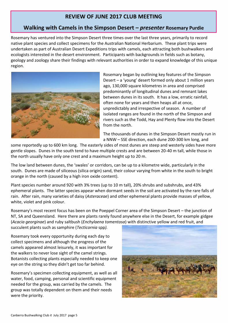
Rosemary began by outlining key features of the Simpson Desert – a ‘young’ desert formed only about 1 million years ago, 130,000 square kilometres in area and comprised predominantly of longitudinal dunes and remnant lakes between dunes in its south. It has a low, erratic rainfall, often none for years and then heaps all at once, unpredictably and irrespective of season. A number of isolated ranges are found in the north of the Simpson and rivers such as the Todd, Hay and Plenty flow into the Desert from the north.
The thousands of dunes in the Simpson Desert mostly run in a NNW – SSE direction, each dune 200-300 km long, and
some reportedly up to 600 km long. The easterly sides of most dunes are steep and westerly sides have more gentle slopes. Dunes in the south tend to have multiple crests and are between 20-40 m tall, while those in the north usually have only one crest and a maximum height up to 20 m.
The low land between dunes, the ‘swales’ or corridors, can be up to a kilometre wide, particularly in the south. Dunes are made of siliceous (silica origin) sand, their colour varying from white in the south to bright orange in the north (caused by a high iron oxide content).
Plant species number around 920 with 3% trees (up to 10 m tall), 20% shrubs and subshrubs, and 43% ephemeral plants. The latter species appear when dormant seeds in the soil are activated by the rare falls of rain. After rain, many varieties of daisy (Asteraceae) and other ephemeral plants provide masses of yellow, white, violet and pink colour.
Rosemary’s most recent focus has been on the Poeppel Corner area of the Simpson Desert – the junction of NT, SA and Queensland. Here there are plants rarely found anywhere else in the Desert, for example gidgee (Acacia georginae) and ruby saltbush (Enchylaena tomentosa) with distinctive yellow and red fruit, and succulent plants such as samphire (Tecticornia spp).
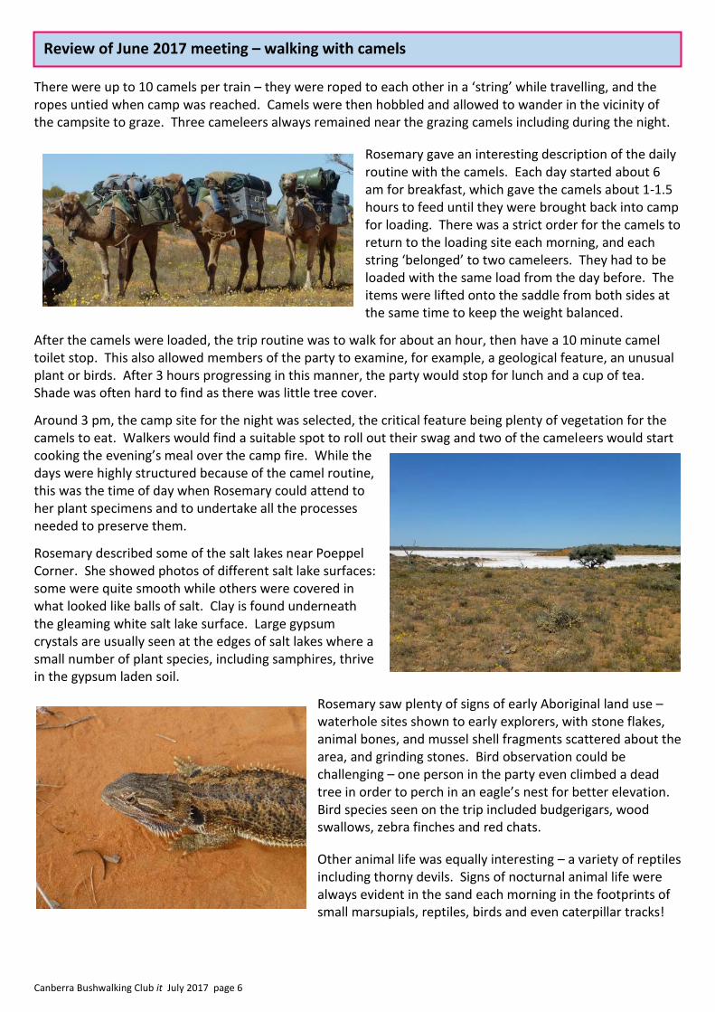
Rosemary took every opportunity during each day to collect specimens and although the progress of the camels appeared almost leisurely, it was important for the walkers to never lose sight of the camel strings. Botanists collecting plants especially needed to keep one eye on the string so they didn’t get too far behind.
Rosemary’s specimen collecting equipment, as well as all water, food, camping, personal and scientific equipment needed for the group, was carried by the camels. The group was totally dependent on them and their needs were the priority.
REVIEW OF JUNE 2017 CLUB MEETING
Walking with Camels in the Simpson Desert – presenter Rosemary Purdie
Canberra Bushwalking Club it July 2017 page 6
There were up to 10 camels per train – they were roped to each other in a ‘string’ while travelling, and the ropes untied when camp was reached. Camels were then hobbled and allowed to wander in the vicinity of the campsite to graze. Three cameleers always remained near the grazing camels including during the night.
Rosemary gave an interesting description of the daily routine with the camels. Each day started about 6 am for breakfast, which gave the camels about 1-1.5 hours to feed until they were brought back into camp for loading. There was a strict order for the camels to return to the loading site each morning, and each string ‘belonged’ to two cameleers. They had to be loaded with the same load from the day before. The items were lifted onto the saddle from both sides at the same time to keep the weight balanced.
After the camels were loaded, the trip routine was to walk for about an hour, then have a 10 minute camel toilet stop. This also allowed members of the party to examine, for example, a geological feature, an unusual plant or birds. After 3 hours progressing in this manner, the party would stop for lunch and a cup of tea. Shade was often hard to find as there was little tree cover.
Around 3 pm, the camp site for the night was selected, the critical feature being plenty of vegetation for the camels to eat. Walkers would find a suitable spot to roll out their swag and two of the cameleers would start cooking the evening’s meal over the camp fire. While the days were highly structured because of the camel routine, this was the time of day when Rosemary could attend to her plant specimens and to undertake all the processes needed to preserve them.
Rosemary described some of the salt lakes near Poeppel Corner. She showed photos of different salt lake surfaces: some were quite smooth while others were covered in what looked like balls of salt. Clay is found underneath the gleaming white salt lake surface. Large gypsum crystals are usually seen at the edges of salt lakes where a small number of plant species, including samphires, thrive in the gypsum laden soil.
Rosemary saw plenty of signs of early Aboriginal land use – waterhole sites shown to early explorers, with stone flakes, animal bones, and mussel shell fragments scattered about the area, and grinding stones. Bird observation could be challenging – one person in the party even climbed a dead tree in order to perch in an eagle’s nest for better elevation. Bird species seen on the trip included budgerigars, wood swallows, zebra finches and red chats.
Other animal life was equally interesting – a variety of reptiles including thorny devils. Signs of nocturnal animal life were always evident in the sand each morning in the footprints of small marsupials, reptiles, birds and even caterpillar tracks!
Review of June 2017 meeting – walking with camels
Canberra Bushwalking Club it July 2017 page 7
Photos illustrating Rosemary’s talk were skilfully presented – cascading photos showing the different sand colours and close-ups of the camels, and overlaying photos of characteristic plants - of pink mulla mulla (Ptilotus polystachyus), pigface (Portulaca intraterranea), goodenia (Goodenia cycloptera), sandhill puncture vine (Tribulus hystrix) and Swan River daisy (Brachyscome iberidifolia) and the dominant perennial grass found over much of inland Australia, the spinifex (Triodia) as well as sandhill canegrass (Zygochloa paradoxa).
In the swales we had pictures of sunray daisies (Rhodanthe floribunda) and remarkably, the very occasional coolibah tree (Eucalyptus coolabah). It is thought that in the Poeppel Corner area, these trees survive by sending deep roots to tap water from ancient river channels. Coolibahs also line the channels of rivers flooding out into the dunefields in the north of the Desert.
Occasional summary text also served to expand information about this unique region.
Thanks Rosemary, for a most interesting and informative talk on walking in the Simpson Desert.
Summary by Sue Vidler Photos provided by Rosemary Purdie
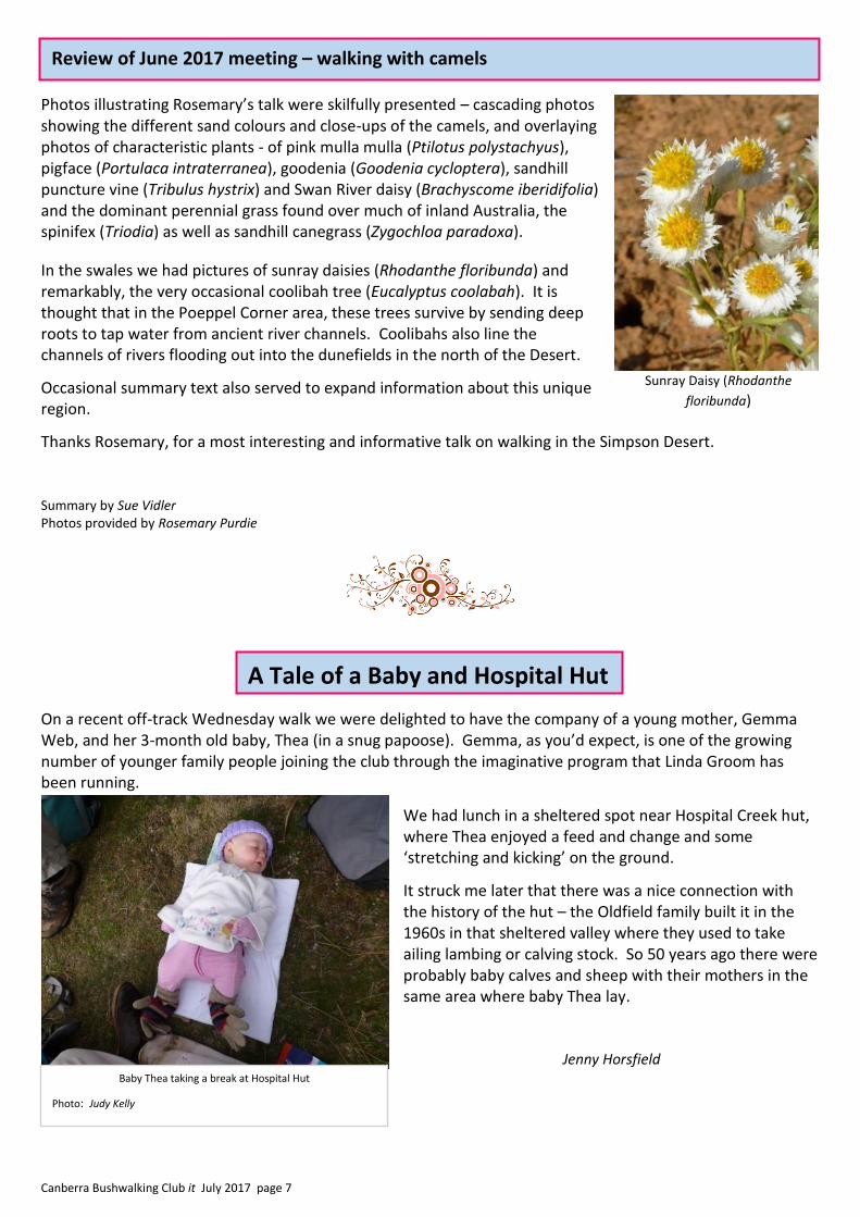
On a recent off-track Wednesday walk we were delighted to have the company of a young mother, Gemma Web, and her 3-month old baby, Thea (in a snug papoose). Gemma, as you’d expect, is one of the growing number of younger family people joining the club through the imaginative program that Linda Groom has been running.
We had lunch in a sheltered spot near Hospital Creek hut, where Thea enjoyed a feed and change and some ‘stretching and kicking’ on the ground.
It struck me later that there was a nice connection with the history of the hut – the Oldfield family built it in the 1960s in that sheltered valley where they used to take ailing lambing or calving stock. So 50 years ago there were probably baby calves and sheep with their mothers in the same area where baby Thea lay.
Jenny Horsfield
Sunray Daisy (Rhodanthe
floribunda)
Baby Thea taking a break at Hospital Hut
Photo: Judy Kelly
A Tale of a Baby and Hospital Hut
A tale of a baby and Hospital Hut
Review of June 2017 meeting – walking with camels

Canberra Bushwalking Club it July 2017 page 8
President: Lorraine Tomlins [email protected] 6248 0456 or 0434 078 496
Treasurer: Julie Anne Clegg [email protected] 0402 118 359
Walks Secretary: John Evans [email protected] 6294 8232 or 0417 436 877
General Secretary: Cynthia Coppock [email protected] 0408 266 501 or 6270 9010(w)
Membership Secretary: Roger Edwards [email protected] 6288 7863
Training and Safety Officer: David Dedenczuk [email protected] 0417 222 154
Conservation Officer: Cynthia Burton [email protected] 0488 071 203
Web Manager: Andrew Meers [email protected]
Editor: Meredith Hatherly [email protected] 6154 1513 or 0413 396 258 Assistant Walks Secretary: Keith Thomas [email protected] +64 27 535 6176
Social Secretary: Jenny Horsfield [email protected] 6231 4535
Publisher: David Williams [email protected] ————————————————————— All members of the Committee can be contacted in one email to [email protected] Check in: [email protected]
Web site: www.canberrabushwalkingclub.org
CANBERRA BUSHWALKING CLUB COMMITTEE
Contributions for the newsletter
Your contributions are welcome in this newsletter. Send anything that you think might be
relevant and of interest to Club members, perhaps a great walk you have been on, an
interesting photo, ideas or articles that have caught your attention, perhaps a letter to the
Editor if there is something you would like to say. If you send a photo, and it is not your
own, you must have the owner’s permission to use it. The name of the photographer will
be included unless they request otherwise.
Please note that any article you send in may be edited to fit, or to correct spelling or other
errors, or to better suit the requirements of the Club.
The closing date for each issue of it is the fourth Wednesday of every month.
Send contributions to [email protected]
Canberra Bushwalking Club it July 2017 page 9
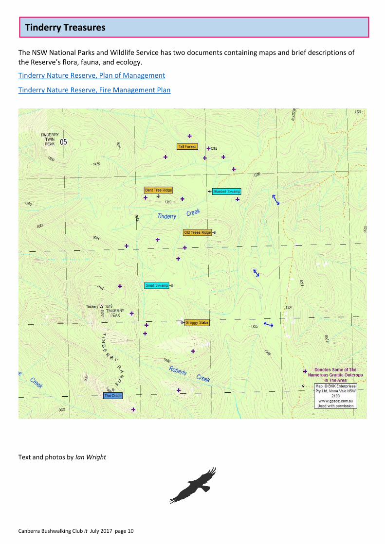
Tinderry Nature Reserve: Eastern Side
The Tinderry Nature Reserve to the south of Canberra has been a regular destination for Club walks for decades. Popular destinations include Tinderry Peak, Tinderry Twin Peak, and The Onion, on the crest of the Tinderry Range. Bluebell Swamp, on the eastern slopes, also receives an occasional visit.
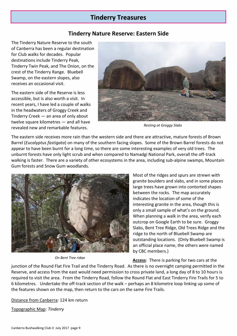
The eastern side of the Reserve is less accessible, but is also worth a visit. In recent years, I have led a couple of walks in the headwaters of Groggy Creek and Tinderry Creek — an area of only about twelve square kilometres — and all have revealed new and remarkable features.
The eastern side receives more rain than the western side and there are attractive, mature forests of Brown Barrel (Eucalyptus fastigata) on many of the southern facing slopes. Some of the Brown Barrel forests do not appear to have been burnt for a long time, so there are some interesting examples of very old trees. The unburnt forests have only light scrub and when compared to Namadgi National Park, overall the off-track walking is faster. There are a variety of other ecosystems in the area, including sub-alpine swamps, Mountain Gum forests and Snow Gum woodlands.
Most of the ridges and spurs are strewn with granite boulders and slabs, and in some places large trees have grown into contorted shapes between the rocks. The map accurately indicates the location of some of the interesting granite in the area, though this is only a small sample of what’s on the ground. When planning a walk in the area, verify each outcrop on Google Earth to be sure. Groggy Slabs, Bent Tree Ridge, Old Trees Ridge and the ridge to the north of Bluebell Swamp are outstanding locations. (Only Bluebell Swamp is an official place name, the others were named by CBC members.)
Access: There is parking for two cars at the junction of the Round Flat Fire Trail and the Tinderry Road. As there is no overnight camping permitted in the Reserve, and access from the east would need permission to cross private land, a long day of 8 to 10 hours is required to visit the area. From the Tinderry Road, follow the Round Flat and East Tinderry Fire Trails for 5 to 6 kilometres. Undertake the off-track section of the walk – perhaps an 8 kilometre loop linking up some of the features shown on the map, then return to the cars on the same Fire Trails.
Distance from Canberra: 124 km return
Topographic Map: Tinderry
Tinderry Treasures
On Bent Tree ridge
Resting at Groggy Slabs
Canberra Bushwalking Club it July 2017 page 10
The NSW National Parks and Wildlife Service has two documents containing maps and brief descriptions of the Reserve’s flora, fauna, and ecology.
Tinderry Nature Reserve, Plan of Management
Tinderry Nature Reserve, Fire Management Plan
Text and photos by Ian Wright
Tinderry Treasures
Canberra Bushwalking Club it July 2017 page 11
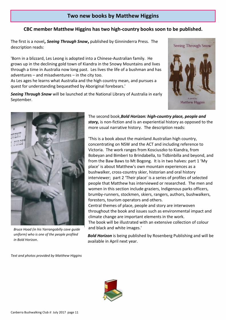
CBC member Matthew Higgins has two high-country books soon to be published.
The first is a novel, Seeing Through Snow, published by Ginninderra Press. The
description reads: 'Born in a blizzard, Les Leong is adopted into a Chinese-Australian family. He grows up in the declining gold town of Kiandra in the Snowy Mountains and lives through a time in Australia now long past. Les lives the life of a bushman and has adventures – and misadventures – in the city too. As Les ages he learns what Australia and the high country mean, and pursues a quest for understanding bequeathed by Aboriginal forebears.'
Seeing Through Snow will be launched at the National Library of Australia in early September.
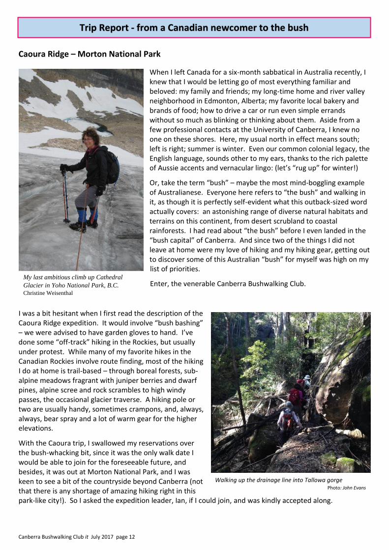
The second book,Bold Horizon: high-country place, people and story, is non-fiction and is an experiential history as opposed to the more usual narrative history. The description reads: 'This is a book about the mainland Australian high country, concentrating on NSW and the ACT and including reference to Victoria. The work ranges from Kosciuszko to Kiandra, from Bobeyan and Bimberi to Brindabella, to Tidbinbilla and beyond, and from the Baw Baws to Mt Bogong. It is in two halves: part 1 ‘My place’ is about Matthew's own mountain experiences as a bushwalker, cross-country skier, historian and oral history interviewer; part 2 ‘Their place’ is a series of profiles of selected people that Matthew has interviewed or researched. The men and women in this section include graziers, Indigenous parks officers, brumby-runners, stockmen, skiers, rangers, authors, bushwalkers, foresters, tourism operators and others. Central themes of place, people and story are interwoven throughout the book and issues such as environmental impact and climate change are important elements in the work. The book will be illustrated with an extensive collection of colour and black and white images.'
Bold Horizon is being published by Rosenberg Publishing and will be available in April next year.
Text and photos provided by Matthew Higgins
Bruce Hoad (in his Yarrangobilly cave guide
uniform) who is one of the people profiled
in Bold Horizon.
Two new books by Matthew Higgins
Canberra Bushwalking Club it July 2017 page 12
Caoura Ridge – Morton National Park
When I left Canada for a six-month sabbatical in Australia recently, I knew that I would be letting go of most everything familiar and beloved: my family and friends; my long-time home and river valley neighborhood in Edmonton, Alberta; my favorite local bakery and brands of food; how to drive a car or run even simple errands without so much as blinking or thinking about them. Aside from a few professional contacts at the University of Canberra, I knew no one on these shores. Here, my usual north in effect means south; left is right; summer is winter. Even our common colonial legacy, the English language, sounds other to my ears, thanks to the rich palette of Aussie accents and vernacular lingo: (let’s “rug up” for winter!)
Or, take the term “bush” – maybe the most mind-boggling example of Australianese. Everyone here refers to “the bush” and walking in it, as though it is perfectly self-evident what this outback-sized word actually covers: an astonishing range of diverse natural habitats and terrains on this continent, from desert scrubland to coastal rainforests. I had read about “the bush” before I even landed in the “bush capital” of Canberra. And since two of the things I did not leave at home were my love of hiking and my hiking gear, getting out to discover some of this Australian “bush” for myself was high on my list of priorities.
Enter, the venerable Canberra Bushwalking Club.
I was a bit hesitant when I first read the description of the Caoura Ridge expedition. It would involve “bush bashing” – we were advised to have garden gloves to hand. I’ve done some “off-track” hiking in the Rockies, but usually under protest. While many of my favorite hikes in the Canadian Rockies involve route finding, most of the hiking I do at home is trail-based – through boreal forests, sub-alpine meadows fragrant with juniper berries and dwarf pines, alpine scree and rock scrambles to high windy passes, the occasional glacier traverse. A hiking pole or two are usually handy, sometimes crampons, and, always, always, bear spray and a lot of warm gear for the higher elevations.
With the Caoura trip, I swallowed my reservations over the bush-whacking bit, since it was the only walk date I would be able to join for the foreseeable future, and besides, it was out at Morton National Park, and I was keen to see a bit of the countryside beyond Canberra (not that there is any shortage of amazing hiking right in this park-like city!). So I asked the expedition leader, Ian, if I could join, and was kindly accepted along.
Trip Report - from a Canadian newcomer to the bush
Walking up the drainage line into Tallowa gorge Photo: John Evans
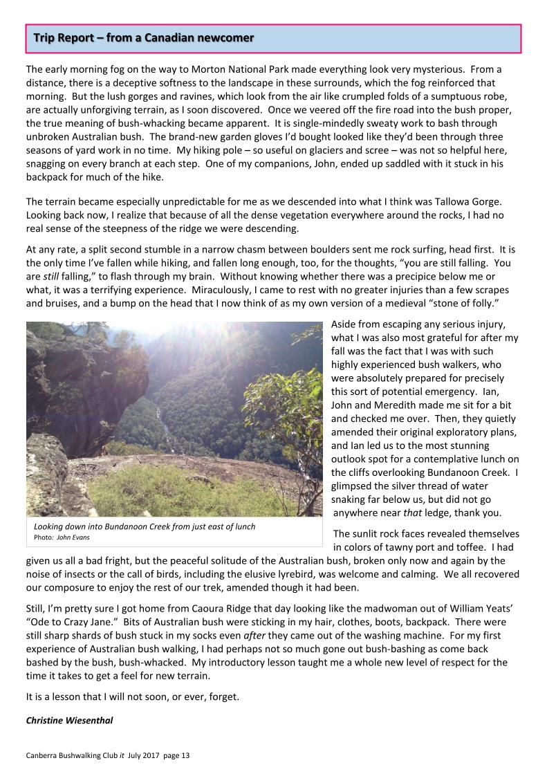
My last ambitious climb up Cathedral
Glacier in Yoho National Park, B.C.
Christine Weisenthal
Canberra Bushwalking Club it July 2017 page 13
The early morning fog on the way to Morton National Park made everything look very mysterious. From a distance, there is a deceptive softness to the landscape in these surrounds, which the fog reinforced that morning. But the lush gorges and ravines, which look from the air like crumpled folds of a sumptuous robe, are actually unforgiving terrain, as I soon discovered. Once we veered off the fire road into the bush proper, the true meaning of bush-whacking became apparent. It is single-mindedly sweaty work to bash through unbroken Australian bush. The brand-new garden gloves I’d bought looked like they’d been through three seasons of yard work in no time. My hiking pole – so useful on glaciers and scree – was not so helpful here, snagging on every branch at each step. One of my companions, John, ended up saddled with it stuck in his backpack for much of the hike.
The terrain became especially unpredictable for me as we descended into what I think was Tallowa Gorge. Looking back now, I realize that because of all the dense vegetation everywhere around the rocks, I had no real sense of the steepness of the ridge we were descending.
At any rate, a split second stumble in a narrow chasm between boulders sent me rock surfing, head first. It is the only time I’ve fallen while hiking, and fallen long enough, too, for the thoughts, “you are still falling. You are still falling,” to flash through my brain. Without knowing whether there was a precipice below me or what, it was a terrifying experience. Miraculously, I came to rest with no greater injuries than a few scrapes and bruises, and a bump on the head that I now think of as my own version of a medieval “stone of folly.”
Aside from escaping any serious injury, what I was also most grateful for after my fall was the fact that I was with such highly experienced bush walkers, who were absolutely prepared for precisely this sort of potential emergency. Ian, John and Meredith made me sit for a bit and checked me over. Then, they quietly amended their original exploratory plans, and Ian led us to the most stunning outlook spot for a contemplative lunch on the cliffs overlooking Bundanoon Creek. I glimpsed the silver thread of water snaking far below us, but did not go anywhere near that ledge, thank you.
The sunlit rock faces revealed themselves in colors of tawny port and toffee. I had
given us all a bad fright, but the peaceful solitude of the Australian bush, broken only now and again by the noise of insects or the call of birds, including the elusive lyrebird, was welcome and calming. We all recovered our composure to enjoy the rest of our trek, amended though it had been.
Still, I’m pretty sure I got home from Caoura Ridge that day looking like the madwoman out of William Yeats’ “Ode to Crazy Jane.” Bits of Australian bush were sticking in my hair, clothes, boots, backpack. There were still sharp shards of bush stuck in my socks even after they came out of the washing machine. For my first experience of Australian bush walking, I had perhaps not so much gone out bush-bashing as come back bashed by the bush, bush-whacked. My introductory lesson taught me a whole new level of respect for the time it takes to get a feel for new terrain.
It is a lesson that I will not soon, or ever, forget.
Christine Wiesenthal
Trip Report – from a Canadian newcomer
Looking down into Bundanoon Creek from just east of lunch Photo: John Evans
Canberra Bushwalking Club it July 2017 page 14
There is a popular bushwalk in the Blue Mountains which starts in Katoomba and reaches Kanangra, via such icons as Narrowneck, the Wild Dogs, Coxs River and Mount Cloudmaker. It is known as the K2K. In our Club this route would be firmly placed in the long/rough category.
There is a brand of walker, commonly known as a tiger walker, who pushes beyond the ordinary efforts of the regular bushwalker. In our own CBC, we have one of these tiger walkers, Dave Drohan, now retired, who still holds a 33 year record for completing the K2K in the fastest time ever recorded. The following is his account of this feat. (Editor)
The Recent K2K record attempt
The classic Blue Mountains bushwalk, the K2K, covers 48km with more than 2km of climbing over the very scenic route between Katoomba and Kanangra. It is normally a three or four day bushwalk.
As a tough challenge, many bushwalkers like to complete it in a day. However, an internet search indicates K2K times under 8 hours are very rare, as the steep climbs, rough terrain and scrubby off track sections deter most runners.
From what can be deduced, I hold the current record, set 33 years ago of 6 hours and 32 minutes. My departure and arrival times were witnessed by Simon Thomas who dropped me off at Cliff drive and picked me up at Kanangra. I was aiming for around 6 hours, but a sore ankle on the last leg slowed me up.
While chatting with Sydney rogainer Glenn Horrocks 6 months ago, I suggested he may be interested in having a crack at the K2K record.
On the 28th May 2017, Glenn took up the challenge and completed the trip in a time of 7 hours, 22 minutes and 49 seconds. He has placed his results on Strava (web location below).
Glenn had my split times with him on his attempt to help determine if he was on schedule to break my time. Discussions with him since indicate he may have another crack at it in a few months’ time, as he thinks he can find at least another 50 minutes. Now that this challenge is out there on Strava, others may also wish to test their mettle, so watch this space. Other known notable times are provided below.
Dave Drohan Retired tiger walker
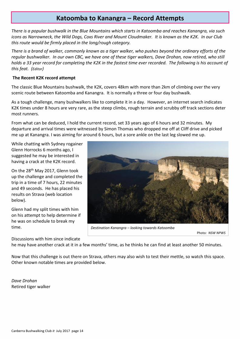
Destination Kanangra – looking towards Katoomba Photo: NSW NPWS
Katoomba to Kanangra – Record Attempts

Canberra Bushwalking Club it July 2017 page 15
Time Holder Date Route
7:16 Ray Jerrems Sept 1971
Kanangra, Mt Cloudmaker, Gentles Pass, Coxs River, White Dog Fire Road, Narrow Neck, Katoomba (Cliff drive)
7:50 David Drohan Oct 1983
Katoomba (Cliff drive), Narrow Neck, Mobs Swamp, Yellow Pup Ridge, Coxs River, Strongleg Buttress, Dex Creek, Mt Cloudmaker, Kanangra
(old car park)
6:32:05 David Drohan June 1984
same as 1983 route
7:22:49 Glenn Horrocks
May 2017
Katoomba (Cliff drive), Narrow Neck, Mobs Swamp, Yellow Pup ridge, Coxs River, Strongleg Buttress, Dex Ck, Mt Cloudmaker, Kanangra (new
car park)
Elevation profile of the route from Katoomba to Kanangra https://www.strava.com/activities/1009425406
Katoomba to Kanangra record attempts
Canberra Bushwalking Club it July 2017 page 16
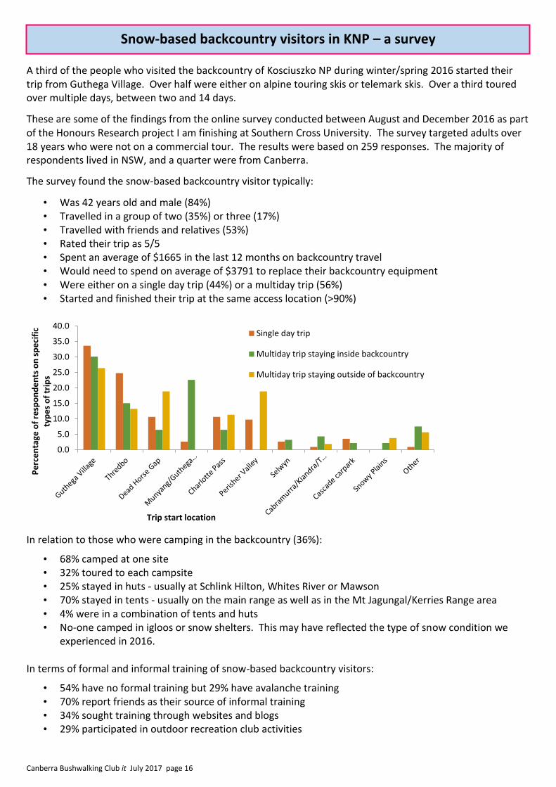
A third of the people who visited the backcountry of Kosciuszko NP during winter/spring 2016 started their trip from Guthega Village. Over half were either on alpine touring skis or telemark skis. Over a third toured over multiple days, between two and 14 days.
These are some of the findings from the online survey conducted between August and December 2016 as part of the Honours Research project I am finishing at Southern Cross University. The survey targeted adults over 18 years who were not on a commercial tour. The results were based on 259 responses. The majority of respondents lived in NSW, and a quarter were from Canberra.
The survey found the snow-based backcountry visitor typically:
• Was 42 years old and male (84%) • Travelled in a group of two (35%) or three (17%) • Travelled with friends and relatives (53%) • Rated their trip as 5/5 • Spent an average of $1665 in the last 12 months on backcountry travel • Would need to spend on average of $3791 to replace their backcountry equipment • Were either on a single day trip (44%) or a multiday trip (56%) • Started and finished their trip at the same access location (>90%)
In relation to those who were camping in the backcountry (36%):
• 68% camped at one site • 32% toured to each campsite • 25% stayed in huts - usually at Schlink Hilton, Whites River or Mawson • 70% stayed in tents - usually on the main range as well as in the Mt Jagungal/Kerries Range area • 4% were in a combination of tents and huts • No-one camped in igloos or snow shelters. This may have reflected the type of snow condition we
experienced in 2016.
In terms of formal and informal training of snow-based backcountry visitors:
• 54% have no formal training but 29% have avalanche training • 70% report friends as their source of informal training • 34% sought training through websites and blogs • 29% participated in outdoor recreation club activities
0.0
5.0
10.0
15.0
20.0
25.0
30.0
35.0
40.0
Pe
rce
nta
ge o
f re
spo
nd
en
ts o
n s
pe
cifi
c ty
pe
s o
f tr
ips
Trip start location
Single day trip
Multiday trip staying inside backcountry
Multiday trip staying outside of backcountry
Snow-based backcountry visitors in KNP – a survey
Canberra Bushwalking Club it July 2017 page 17
The research project was particularly interested in how prepared snow-based backcountry visitors were and how experienced they were. Generally, respondents appeared to be well experienced with an average of:
• 15 years of previous snow-based backcountry travel • 27 trips completed in their lifetime • 20 trips in KNP • 3 trips in the 2016 season • However, 29% were on their first trip. • 64% had taken snow-based backcountry trips overseas and 42% had taken trips in Victoria and
Tasmania during their life time.
Overall respondents were well prepared. This may reflect their high level of experience, the overall high levels of competence they reported, and how important they felt snow-based backcountry travel is to them. To plan their trip, they used a range of resources:
• 90% took note of weather forecasts prior to their trip • 76% used maps • 55% used websites and blogs • 38% talked to friends • 79% notified a family member or partner and 50% a friend when leaving for their trip • 74% carried or used more than seven safety items as identified as essential for alpine backcountry
travel by the NSW National Parks and Wildlife Service • Having said that, 19% travelled alone.
In addition to this aspect of snow-based backcountry travel, the survey asked respondents about their reasons for travelling, as well as questions about wilderness and the infrastructure within the backcountry.
Main Reason for visiting Wilderness experience • Experience new skill or place (35%) • Enjoyment and fun (23%) • Activity (22%) • Share with others (8%) • Escape from crowds or home (6%) • Attend for an event (6%)
• 65% experienced some wilderness and 25% complete wilderness
• Therefore wilderness can be perceived as a motivator for trip
• 58% said wilderness means an absence of people or facilities
Backcountry Infrastructure Remote Toileting • Access is adequate (60%) • Huts adequate (35%) • Camping adequate (49%) • Toilet adequate (29%) • Signage adequate (37%)
• Used toilets at entry/exit location (49%) • Resorts (22%) • Hut (17%) • Buried in snow (14%) • Packed out (13%)
The outcome of the survey has been very positive as it appears to fill a void in knowledge about who is visiting the backcountry. The survey was supported through sponsorship from NSW National Parks and Wildlife Service, Rhythm Snowsports and Mont Adventure Equipment. The project was supervised by Dr Pascal Scherrer and Dr Mieke Witsel from Southern Cross University and Dr Isabelle Wolf from NSW Office of Environment and Heritage. For further information I can be contacted on [email protected].
Jennifer Smart
Report referred by CBC member Rowan Peck who met Jennifer while they both worked at Perisher. Rowan participated in this survey (ed).
Snow-based backcountry visitors in KNP – a survey
Canberra Bushwalking Club it July 2017 page 18
Information for Participants
Distance and difficulty
Distance: (S) Short – under 12 km/day (M) Medium – 12–20 km/day (L) Long – over 20 km/day Note: In calculating distance, 1 km is added for every 100 metres climbed.
Terrain: (E) Easy – fire trail, tracks, beaches etc (M) Medium – bush tracks, alpine areas, some scrub (R) RouTgh – much scrub, steep climbs, rock scrambles (W) Wet – compulsory swims, many river crossings (X) Exploratory
Booking Contact the leader early rather than late so the leader has time to arrange transport. See walk description for booking deadline. Check with the leader about: * the need to carry water, tents/fly, maps, etc. * appropriate clothing, footwear * any precautions you might need to take for severe weather changes. Ask about anything you’re unsure of, especially if you are new to our Club.
Equipment hire Take advantage of the excellent gear that the Club has available for hire before lashing out on your own equipment. The Equipment Officer is Rob Horsfield, who can be contacted on 6231 4535(h) or to borrow the Northside PLB, Lorraine Tomlins, 62480456 or 434078496. The equipment available and current rates per weekend/week are set out below. Hirers are responsible for collecting and returning the equipment. The hiring charge (but not the deposit) is waived for members who are ‘first time’ weekend walkers. A deposit of $20 is required and part or all of this will be refunded, depending on the condition of the items upon return and whether they are returned late.
Item w.e./week
Olympus two person tent $15 / $40 Macpac Microlight one person tent $15 / $40 Snow tent $15 / $40 3 season bag, mat and liner $10 / $25 Assorted packs $5 / $15 Trangia and fuel bottle $5 / $15 Snow shoes/poles $10 / $25 Snow sleeping bag, mat and liner $15 / $40
Personal locator beacon – nil (see website for conditions) GPS – nil (see website for conditions of use)
Check you have ALL the bits and pieces you need when collecting and returning gear.
Transport Costs are 38¢/km/car, divided equally among all participants. This amount may be varied at the discretion of the leader, depending on the condition of the roads and other factors. The figures given are for the car as a whole and then, at the discretion of the leader, an estimate or range per person. Park admission and camping fees are additional costs which leaders should list separately.
Duty of care Every person taking part in a CBC activity acknowledges that he/she does so voluntarily and that he/she may be exposed to risks that could lead to injury, illness or death, or to loss of, or damage to property. Each person is required to sign the Club’s ‘Acknowledgement of Risks’ form. Visitors are welcome to join trips. However walkers are strongly encouraged to join the Club after a maximum of three trips.
For further information see: www.canberrabushwalkingclub.org
Check-in after walks Before a trip leaders are to email or phone through the names of their party, and by 10 am the day after their trip report their safe return or trip cancellation, to the Check-in Officer, David Dedenczuk ([email protected] 0417 222 154 leave message if no answer). In the event that you are late returning, worried relatives should contact the Check-in Officer or the Walks Secretary (6294 8232 or 0417 436 877) in the first instance, not the Police or other bodies.
Map scale is 1:25,000 unless otherwise stated
Wednesday walks Two walks one Medium/Easy and one Medium/Hard, are conducted most Wednesdays. Walks are conducted in turn by leaders from the Canberra Bushwalking Club (CBC), Brindabella Bushwalking Club (BBC – Peter [email protected] and Kathy [email protected]) and National Parks Association ACT (NPA - Mike S, 0412 179 907). Destination and meeting place details are emailed a few days before each walk. (BBC and NPA leaders as listed in the activity program). Control your receipt of Wednesday Walk emails via your membership profile. Contact John, co-ordinator of Wednesday Walks, via [email protected] for general enquiries. If you are not a member of CBC, BBC or NPA you must contact the leader before the walk to discuss the level of difficulty and must be accompanied on the walk by a sponsoring member. Please note that leaders retain the right to not accept any walker.
ACTIVITY PROGRAM for JULY it 2017 Arrange for your Club-related activities to be included in the program with
John Evans (Walks Secretary) Ph: 6294 8232 or 0417 436 877. Email: [email protected]. Post: Villa 68, 200 Woodcock Drive, Gordon
Canberra Bushwalking Club it July 2017 page 19
Saturday 15 July: Wild Cattle Creek - M/M This walk is south of Captains Flat in the Tallaganda National Park. It is a wander, mostly off track, along ridges through light, open forest and along the wide, open valley of Wild Cattle Creek and other watercourses. About 10km and 4 hrs actual walking. Map: Tinderry. Leader: Stan Marks 6254 9568 [email protected] Transport: ~$20.
Saturday 15 July: Mt Coree – L/E All on fire trails from Blundells Flat. Up Curries Rd, along Two Sticks Rd, past the Coree Camp Ground on Pabral Rd and up the Coree Summit Rd. Excellent views on a clear day. Return clockwise around Pabral Rd. 2 geocaches. Around 19km, 800m climb and 6 hours. Map: Cotter Dam. Leader: John Evans 0417 436 877 [email protected] . Transport: ~$8 per person.
Sunday 16 July: Orroral Homestead and Lunar Laser Dome M/E-M We will follow the Orroral Valley Heritage Trail from the Nursery Swamp Carpark to the Orroral Homestead
and then to the site of the Orroral Valley Tracking Station. We will then follow the trail up to the Lunar Laser Dome and return by the same route. Approx 14km and 500m climb. Map: Rendezvous Creek. Transport: ~ $10 ea. Leader: Lisa Quilter 0402 928 359, [email protected]. Bookings: By email before noon 14 July.
Wednesday 19 July: Wednesday Walks E-M leader Robyn Gallagher (BBC), M-H leader Barrie Ridgway (BBC).
Wednesday 19 July: CBC General Meeting: Meg McKone- Bushwalking in Central Qld
7.30pm Hughes Baptist Church Hall 32-34 Groom Street, Hughes
Friday 21 July: Burley Griffin Ramble Part 1 - L/E
Day 1 of a four day circuit of Lake Burley Griffin and some nearby ridges and hills. Sign up for the full walk or just come for a day or two. From Yarralumla we'll head to Weston Park and on to the National Arboretum before finishing at Black Mountain. Map: Canberra. Leader: Terence Uren [email protected] Transport: Drive yourself.
Friday evening-Sunday 21-23 July: Whites River Hut snowshoe, Kosciuszko NP – S–M/M
After camping at Island Bend on Friday night, we start early Saturday from Munyang following the fire trails up Schlink Pass to Horse Camp Hut and on to Whites River Hut for an overnight stay. Share or build your skills snow camping, and in emergency alpine shelters. Return via the opposite side of the valley to Munyang on Sunday. About 20km and 450m climbing and descent on alpine fire trails. Map: Geehi Dam. Leader: Rowan Peck 0412 041957. Bookings: [email protected] by 8pm Wednesday 19th July. Transport: about $160 per car from Canberra, plus park entry fees if applicable. Limit: 8.
Saturday 22 July: Pinnacle to Black Mt - S/E
Meet 8.30am at the car park at the end of Frith St behind the Black Mt CSIRO and near the electricity substation. We will then car shuffle to Dungowan St, Hawker where we will start the walk at about 8.45. We will walk through the Pinnacle Reserve and then walk to Mt Painter, with good views to the Brindabellas, then lunch near the Aranda Bushland. Back to the cars via Black Mt Reserve by 2pm. Map: Canberra. Leader: Jenny Stewart 62864059 [email protected]. Co-leader Stan Marks. Transport: drive yourself but please book as I may need to ask you to give someone a ride.
Activity Program July it 2017

Canberra Bushwalking Club it July 2017 page 20
Saturday 22 July: Burley Griffin Ramble Part 2 - L/E Day 2 of a four day circuit of Lake Burley Griffin and some nearby ridges and hills. Sign up for the full walk or just come for a day or two. From Black Mountain we'll head through ANU and then follow the lake shoreline to Acton, Kings Park, Aspen Island, Grevillea Park, Molonglo Reach, Jerrabomberra Wetlands, Bowen Park, Reconciliation Place and Lennox Gardens. Map: Canberra. Leader: Terence Uren [email protected] Transport: Drive yourself.
Sunday 23 July: Burley Griffin Ramble Part 3 - L/E Day 3 of a four day ramble circuit of Lake Burley Griffin and some nearby ridges and hills. Sign up for the full walk or just come for a day or two. We leave the lake today and head along Stirling Ridge on the way to Red Hill Nature Reserve, Mt Mugga Mugga Nature Reserve, Isaacs Ridge and Farrer Ridge. Maps: Canberra, Tuggeranong. Leader: Terence Uren [email protected] Transport: Drive yourself.
Monday 24 July: Burley Griffin Ramble Part 4 - L/E The final day of our four day circuit of Lake Burley Griffin and some nearby ridges and hills will take us back to where we began via Mt Taylor, Oakey Hill, Curtin Horse Paddocks and the Old Canberra Brickworks. Maps: Canberra, Tuggeranong. Leader: Terence Uren [email protected] Transport: Drive yourself.
Wednesday 26 July: Wednesday Walks
E–M leader Peter Ford (CBC), M-H leader Philip Gatenby (NPA).
Wednesday 26 July - Tuesday 8 August: Ridges and gorges of Razorback, West MacDonnells M/R/partly X You will need to be in Alice Springs on Tues 25 July and not leave until Wed 9 August. Two walks, mainly off-track, in the West Macs. Week 1: Six days exploring the narrow ridges and gorges on the western side of Mt Razorback from base camps by delightful pools in Crawford Creek, and returning to Redbank Gorge. I don’t know what we will find, but it looks spectacular! Off-track walking with steep climbs and scrambles, possibly wet. Week 2: Eight days along the seldom-visited north side of the Chewings Range between Ellery Creek and Hugh Gorge, including Peak Alone (unnamed, 1179 metres), sections of the main ridgeline and small gorges, with explorations at the northern end of Hugh Gorge. Also on the CMW program. Maps: West MacDonnell NP Maps 1 and 2. Leader: Meg McKone 6254 5902 [email protected] Transport: $ lots. Return flights to Alice Springs plus bus transport to start and end of walks ~$250. This trip is now full.
Thursday evening 27 July: Lake Burley Griffin evening cycle Heading off at 6:30 pm, a quick cycle anti-clockwise around the whole lake. You will need a good lamp, beanie and gloves. Map: Canberra. 30km, taking about 1.5 hours. Book by cob Tuesday 25 July. Leader: David Dedenczuk 0417 222 154 [email protected] Transport: drive yourself to meeting point to be advised.
Saturday 29 July: Callaghan Hill – M/M, ptX
A loop on management trails and off-track in the northern part of the Rob Roy Nature Reserve east of Conder. The walk begins with a 300m climb over 3km, passing through Big Monks with views to Mt Tennent, Booroomba Rocks and the Tidbinbilla Range. The track dips then climbs again for views over the solar farm beside the Monaro Highway. Around 12km and 700m climb. Map: Tidbinbilla. Leader: John Evans 0417 436 877 [email protected] . Transport: ∼$5 per person.
Activity Program July it 2017
Canberra Bushwalking Club it July 2017 page 21
Saturday 29 July - Sunday 3 September: Central Australia - M/M Three weeks in the red centre, camping beside the cars and doing day walks. We will also spend a week
driving there and another week coming back seeing interesting places along the way. Leaders: Linda Stone and Jeff Bennetts [email protected] . Vehicles travelling from Canberra are full but we will accept bookings on a reserve list.
Wednesday 2 August: Wednesday Walks E-M leader Leigh Hermann (BBC), M-H leader Prue Deacon (BBC). Sunday 6 August: Snowy Corner – M/M
A steep uphill walk to Snowy Corner on the track to Mt Tidbinbilla. There will be a little cold wet scrub and steep wet slippery rocky terrain to contend with. Accordingly, participants should have some appropriate experience. If snow should make the walk impractical, we will go up the Camel Back Trail, perhaps as far as Camels Hump. Map: Tidbinbilla. 12km, including effort for climb. Climb 500m. Book by COB Thursday 3 August. Leader: David Dedenczuk 0417 222 154 [email protected] Transport: ~$30 per car.
Sunday 6 August: Nil Desperandum – M/E From the Tidbinbilla Visitor Centre we will follow the Congwarra Trail and then through Jedbinbilla to Nil Desperandum, a restored homestead that was built around 1895. This will be a journey back in time giving us a glimpse into a way of life long since gone. Around 14 km all on track with some steep sections, total outward climb of 220 m and total homeward climb of 190 m. Map: Tidbinbilla. Leader: Phillip Starr 0419 281 096, [email protected] Transport: $20 per car ($5 - $7 per person). Booking: Please book by email before 2 pm Friday 4 August.
Wednesday 9 August: Wednesday Walks E-M leader Mike Morriss (CBC), M-H leader Peter Wellman (BBC).
Saturday 12 August: Centennial Trail, Mulligans Flat to Hall - M/E
Park the cars next to the public toilets in the park off Gladstone St, Hall. We will car shuffle to Mulligans Flat from where we will walk back to Hall along the Centenary Trail. The walk is about 18km and has 400m of climb. It has many good views. Map: Hall Leader: Diana Kirby, 0421 851 212 [email protected] Transport: Drive yourself. Book: by Thursday evening.
Saturday-Friday 12-25 August: Central Australia - shorter option - M/M Join two others and fly to Alice Springs and hire a vehicle for two weeks of day walks and car camping, visiting the Western Macdonnells (Larapinta), Watarrka (Kings Canyon), Uluru, and Kata Tjuta. Leaders: Linda Stone and Jeff Bennetts [email protected] . Room for one or two more in the hired vehicle (seven are driving from Canberra). Please make, by email, an expression of interest without delay if you would like to join us.
Sunday 13 August: Sherwood Daffodils – S/E From Mountain Creek Road we will walk two kilometres gaining 165 metres in altitude to an open ridge with expansive views. We then proceed to Sherwood Homestead site for morning tea among the daffodils and jonquils. Our return is by a different route. Total distance is about 8 km (Mostly on forest roads and tracks). Total climb is about 300 metres. We will be home in time for lunch. Map: Cotter Dam. Leader: Phillip Starr 0419 281 096, [email protected] Transport: $5 - $6 pp Booking: Please book by email before 2 pm Friday 11 August.
Activity Program July it 2017

Canberra Bushwalking Club it July 2017 page 22
Wednesday 16 August: Wednesday Walks E-M leader Peter Ford (BBC), M-H leader Peter Wellman (BBC).
Wednesday 16 August: CBC General Meeting: 7.30pm Hughes Baptist Church Hall 32-34 Groom Street, Hughes
Sunday 20 August: Sydney Spit Bridge to Manly – S/E
This is a lovely coastal walk taking in some of Sydney Harbour’s best sights, sounds, and smells. 10km on a mix of beach, track, and pathway. The perfect way to round out a weekend if you happen to be in Sydney, for say, a major Rugby game the night before (Australia vs NZ). Aiming to be finished in time for a lunchtime ride on the ferry back to the city. Details: see http://short-walks.com.au/new-south-wales/sydney/spit-bridge-to-manly-walk/. Leader: Rowan Peck ph 0412 041957 [email protected] Transport: Make your own way to Sydney, or contact the leader for other options. Public Transport to and from Sydney city. Book: preferably by email by Tuesday 15th August. Limit: None.
Wednesday 23 August: Wednesday Walks E-M leader Tim Wright (CBC), M-H leader Barrie Ridgway (NPA).
Saturday 26 August: Snow shoe walk around Perisher valley - M/E Meet at Perisher NPWS station for a 9:30am start. Follow marked trails around and perhaps venture into back country around Perisher with at least one stop at a coffee shop for refreshment. Route will be varied depending on the party and may take us past Mount Perisher or to Porcupine Rocks. Suitable for fairly fit beginners. Snow shoes can be hired from the Club or in Jindabyne. It is recommended that participants go up the previous day and camp at Jindabyne or in the Park as the leader will. If coming up for the day a 5:30am departure from Canberra may be necessary. Maps: Perisher and snow shoe walking maps available from NPWS station. Leader: Tim Wright 6281 2275, 0409 847 534 [email protected] Book: by 9pm Thursday 24 August. Transport: $38 per person plus Park entry. Limit: 12.
Saturday 26 August: Wild Cattle Flat - S/E-M
Climb via fire trail east of Captains Flat to the trig station atop the Bollard Ridge from which there are views to the west. Then follow the ridge as it descends through open forest until you cross Ballinafad Creek. Lunch on a hill above the creek, then cross Wild Cattle Flat and back to the cars through open forest. All on track or easy off track. 8km, 300m total climb, about 4 ½ hrs actual walking. Map: Tinderry. Leader: Stan Marks 6254 9568, [email protected] Transport: ~$20.
Tuesday evening 29 August: Navigation refresher #1 An evening with map and compass This is at the home of Jenny and Rob Horsfield 62314535(h). [email protected]. Wednesday 30 August: Wednesday Walks
E-M leader Robin Cayzer (CBC), M-H leader Steven Forst (NPA).
Saturday 2 September: London Bridge and Googong Dam - S/E Starting at the London Bridge car park, we will walk to London Bridge itself, a natural arch, and on to
Washpen Crossing at the southern end of Googong Dam. From there, to the London Bridge homestead
and back to the cars. Walk will be just under 4 hrs and involves few hills. Transport: est $10. Map:
Hoskinstown. Leader: Stan Marks 6254 9568 (h) or [email protected]
Activity Program July it 2017

Canberra Bushwalking Club it July 2017 page 23
Tuesday 5 September: Navigation refresher #2 An evening dead-reckoning exercise – S/E This revisits the techniques of navigation for conditions of minimal visibility using a ramble out from Jenny
and Rob’s home. 6231 4535(h). [email protected].
Wednesday 6 September: Wednesday Walks E-M leader Robyn Gallagher (BBC), M-H leader Peter Dalton (BBC).
~ Friday 8 September – ~ Sunday 8 October: Wandering the Wet Tropics of Queensland - various gradings Several bushwalks spread over about one month visiting the tropical coast and hinterland between Townsville and Cairns. It will be possible to join and leave at many points. We will start with the Hinchinbrook Island Thorsborne Trail, 8 to 14 Sep (Grade M/M). Limit 6 for this section. After that, options include: (a) kayak camping on Kent Island in the Barnard group; (b) camping and day walking in the Rainforest National Parks near Tully (M/E); (c) an attempt on Mt Bartle Frere 1611m the highest point in Queensland, climbing from the west and camping at the Western Summit camp; if cloud is forecast then an easy visit to the crater lakes near Atherton, 2 days, (M/R); (d) day walking and car camping at Undara Lava Tubes National Park, perhaps four days (S-M/E). Those driving back towards Canberra may like to visit White Mountains NP or Carnarvon NP (note, some access restrictions). Maps: tba. Transport: Fly then hire cars, or drive from Canberra 2400km each way. Google maps suggests a driving time of 21h, perhaps three days. Leader: Peter Conroy, 0409 764 785, [email protected].
Saturday 9 September: Navigation refresher #3 Position fixing – M/M This is a day-ramble in the hills and on the river at the back of Kambah consolidating position finding
techniques. ~200m climb and 15km distance. Map: Tuggeranong. Leaders: Jenny and Rob Horsfield 6231 4535(h), [email protected].
Wednesday 13 September: Wednesday Walks
E-M leader Cynthia Breheny (CBC), M-H leader Jenny Horsfield (CBC). Saturday-Sunday 16-17 September: Navigation refresher #4 Sentry Box Mountain – M/R Off track in Namadgi. Day 1: Naas car park: Waterhole Hut– Sheep Station Creek–Lutons Hut. ~200m
climb and 10km distance. Day 2: Lutons–Sentry Box and return as a side trip, Naas Valley to the car park. ~600m climb and 12km distance. Map: Yaouk. Leaders: Jenny and Rob Horsfield 6231 4535(h). [email protected]. Transport: ~$48 per car.
Tuesday 19 September: Mt Gudgenby and beyond – L/R
Most people have been to the summit of Mt Gudgenby, but most do not venture to the magnificent rock stacks north of the summit. We will be going to both to locate two geocaches GC1KJHZ and GC16F0A. Some thick scrub and some granite scrambling involved. About 20 kilometres in distance and 900 metres of climbing. Early start. Map: Yaouk. Leader: Roger Edwards 6288 7863 h 0406 378 217 [email protected]. Transport: $40.00. per car. Limit: 8.
Tuesday evening 19 September: Navigation refresher #5 Introduction to GPS An evening at the home of Jenny and Rob Horsfield 6231 4535(h), [email protected].
Wednesday 20 September: Wednesday Walks E-M leader Linda Groom (CBC), M-H leader Mike Smith (NPA).
Activity Program July it 2017
Canberra Bushwalking Club it July 2017 page 24
Saturday 23 September: Navigation refresher #6 Use of GPS to navigate – S/E Revisiting #2 using Waypoints and Routes. Map: Tuggeranong. Leaders: Jenny and Rob Horsfield
6231 4535(h), [email protected].
Saturday-Monday 24-26 September: Jervis Bay – various grades
I have booked a large house at Vincentia for the weekend. Leave Canberra Saturday morning and, on
Saturday afternoon, do a walk from Governor Head with spectacular views of both the coastline and the
ranges to the west. On Sunday, walk to Steamer’s Beach, St George’s Head and Summerland Bay through
coastal forest and heath with many sea views, and morning tea and lunch on beaches. 4½ hrs actual
walking. The house is well equipped so shared meals in house both nights. We will probably spend
Monday morning in the National Botanic Gardens Jervis Bay annex before leaving for home. Lunch will be
at the eatery on Cambewarra Mt, with views north, east and south. Maps: Sussex Inlet,
Huskisson. Leader: Stan Marks 6254 9568 or [email protected]. Transport: $70, including park fees.
Accommodation: about $90-100 for weekend, assuming a full house. Note: I will be away from about 23
July to 23 August.
Wednesday 27 September: Wednesday Walks E-M leader Robyn Gallagher (BBC), M-H leader Peter Dalton (BBC).
Thursday evening 28 September: Navigation refresher #7 GPS and PC software
An evening demonstration of PC software and digital maps to plan and analyse trips recorded on a GPSr. 0417 436 877. [email protected] to book.
Saturday 30 September - Monday 2 October: Ettrema Plateau to Possibility Point - M/M
From the carpark on Greta Rd, walk 16 kms out along the Ettrema Plateau on the old 4WD track past Rodgers Hill to a base camp at Manning Saddle. On Day 2, with a day pack, continue on to Possibility Point for superb views into Ettrema Gorge and Cinch Creek, then back to Manning Saddle. On Day 3, return 16 km to the cars. Mostly on track, with some scrub on the final km and a half to Possibility Point. No significant climbs, as we will be walking along an undulating plateau. Total distance approx 44 km. Magnificent spring wildflowers are to be expected along the plateau. Maps: Nerriga, Touga, Yalwal. Leader: Meg McKone 6254 5902 (h), [email protected] Transport: TBA. Book before Thursday 28 September.
Sunday 15 – Saturday 28 October: Sundown, Girraween, Bald Rock, Richmond Ranges NPs - M/M
Weeks 3 and 4 of October. Approx two weeks of car camping with day and overnight walking in a selection of these and possibly other NPs in Southern Queensland and Northern NSW. There are two 2-3 day walks in Sundown NP and day walks of different lengths in them all. Spectacular spring flowers in some, rainforest in Richmond Range. Also on the CMW program. Maps: See leader. Leader: Meg McKone 6254 5902; [email protected]. Transport: $$$.
Saturday-Sunday 21–22 October: S24C#7 – Hospital Creek Hut – S/E
Day 1: Starting at Yankee Hat Picnic Area we will visit Yankee Hat Rock Art, cross Bogong Creek, then a short cross country section through open forest to Old Boboyan Road. Camping by Hospital Creek Hut (Water Tank/Fire Place). Day 2: A morning return by Old Boboyan Road, Gudgenby Reforestation Area and ACT Forest Hut. Ideal bush break for busy people. Suitable as an overnight pack trip for beginners. Map: Yaouk. Leader: Sean Sunley 0433 073959 [email protected]. Transport: ≈ $50 per car. Book: Preferably by e-mail before 1800 Thu. Limit: 16.
Activity Program July it 2017

Canberra Bushwalking Club it July 2017 page 25
Wednesday 25 October: Long Flat and Burnt Hill, Namadgi National Park – M/E From the car park next to the Mt Clear Campground we walk through the foothills of the Clear Range along the Long Flat Fire Trail, initially to the South South-West for 1.7km, and then turning to the South-East near the junction with Burnt Hill Fire Trail. We continue along the Long Flat Fire Trail for another 7km to Long Flat where the trail swings, in a meandering way, roughly towards the South-West soon meeting the Carey Fire Trail which runs along the ACT's southern border with NSW. We turn right at the border, following the undulating path of the Carey Fire Trail westward for 4.8km until we reach Burnt Hill. From there we turn right again, this time into the Burnt Hill Fire Trail for 3.6km, mostly along Grassy Creek, back to the cars. Around 17km and 410m climb. Maps: Bredbo, Colinton and Shannons Flat. Leader: Mark Peirce 0405 357 654 [email protected] Transport: Driving distance 108km return. Pay $13 to drivers.
Wednesday-Friday 1-3 November: Mt Jagungal from Round Mountain - L/M Mid week walk to Mt Jagungal from Round Mountain. A spring amble to 2061m the highest point in Kosciuszko north of the main range, with views from Namadgi to Mt Bogong in Victoria. Camping near the source of the Tumut River. The walk is on fire trail and footpad. Around 30km and 500m climb. Requires 4 season tents and cold weather sleeping bags. Map: Jagungal Leader: Peter Conroy 62814917 [email protected] Transport: Cars to Round Mt carpark. Limit: 10.
Wednesday 1 November – Sunday 31 December: Australian Alps Walking Track with Mac Kirby – L/R ptX I plan to walk the Australian Alps Walking Track in the spring / early summer of 2017. I expect to take about a fortnight for each of the three sections: Walhalla to Hotham, Hotham to Thredbo, Thredbo to Tharwa. I plan to take a couple of days break between sections (i.e.in Hotham and in Thredbo). I will welcome companions for the whole walk or for parts of it. Exact dates and other details to be worked out to suit the party. Please communicate any expression of interest. Maps: tba. Leader: Mac Kirby 0422 585 519, [email protected]
Thursday-Saturday 9-25 November: The Great South West Walk on foot and by canoe - M-L/E
The Great South West Walk is one of Australia’s lesser known long-distance walking tracks. Stretching over 240 km, it takes in coastal, forest and river landscapes in south-western Victoria and is serviced by a series of established overnight shelters/campsites. The plan is to do the walk in three stages: starting from Nelson, near the South Australian border, we walk along the wild and isolated shore-line of Discovery Bay for three nights – this is zen time. The beach morphs into a long series of coastal cliffs for the next three days, passing Capes Bridgewater and Nelson, to reach the town of Portland at the end of day 6 – time for a day off. From Portland, the route takes us inland for the next three days, through the Cobboboonee Forest and Lower Glenelg National Park to reach Moleside Campsite on the Glenelg River. From here the pace changes, as we won’t be walking the last section, but canoeing down the Glenelg River, as it flows through the national park, for the next four days. There will be time to visit the Margaret Rose Caves on the way before arriving back at Nelson at the mouth of the river. The itinerary can be downloaded at www.gang-gang.net/nomad/GSWW-Itinerary.pdf . Walking days vary from 15-22 km between the campsites: the route does not have a lot of climbing, but there are a few days of beach walking. It is planned to make food drops to lighten the load for the nine days of walking. Maps and information: http://www.greatsouthwestwalk.com/ Leader: David Briese [email protected] Costs: $4-500 per person for campsite fees, accommodation and canoe hire. Travel: You can fly to Portland, but driving is probably the best option – ca 2000km round-trip between Canberra and Nelson, which would be ca. $250 per person return if 3 cars are used (based on 8 people – may vary slightly if less) Limit: 8.
Activity Program June it 2017

Canberra Bushwalking Club it July 2017 page 26
Saturday 11 November: Stockyard Spur, Pryors Hut and Mt Gingera - L/M The walk will start from Corin Dam. We will then climb steeply up Stockyard Spur to Pryors Hut where we'll have a very well-earned morning tea. From there we climb to Mount Gingera for lunch and magnificent views. Expect snow gums and alpine meadows and a chance to reacquaint yourself with your quads and hammies as this walk is about 20 km and a total climb of 1150 m. A good level of fitness is definitely required. Map: Corin Dam. Leader: Terrylea Reynolds 0408715218 [email protected] Transport: $10 per person. Book: by 2pm Wednesday 8 November.
Saturday-Sunday 2-3 December: Bimberi Peak – M/E
This is a good introductory trip for day walkers who would like to try out overnight camping. It also provides an opportunity to climb Bimberi Peak (1913 metres), the highest peak in the ACT. We'll depart Canberra at 1:00pm on Saturday and drive via Adaminaby to the locked gate at the northern end of Pockets Saddle Road. With overnight packs we'll walk to Oldfields Hut where we'll camp overnight (3.5 km). The next morning, with day packs only, we'll take the trail to Murrays Gap (4.5 km and 200 metres climb). We'll ascend Bimberi Peak from Murrays Gap following a footpad to the summit (3 km and 390 metre climb). Following morning tea with fabulous 360 degree views we'll return along the same route back to Oldfields Hut for lunch and then back to the car. Maps: Rendezvous Creek, Rules Point or Rooftop's Kosciuszko Northern Activities. Leader: Gerald Dodgson 0438119803 [email protected] Transport: Approximately 350 km, $140 per car, $35-45 per person. Book: by 2pm, Thursday 30 November. Limit: 16. .
Activity Program June it 2017
Canberra Bushwalking Club it July 2017 page 27
The Bulletin Board is for members to advertise (at no cost) goods for sale, private trips or other personal bushwalking-related matters. The Club is not involved in, takes no responsibility for, and does not endorse, the activities or goods advertised here. Hence, if people participate in any activities advertised here, they do so as private individuals, not as members of the Club, and will not be covered by the Club’s insurance. Notices for the Bulletin Board should be emailed to the Walks Secretary [email protected]
Ski-Orienteering The 2017 NSW and ACT Ski-Orienteering championship will be held at Perisher Valley on Sunday 13 August. Contact David Poland [email protected] for further information.
Hone your navigation – go rogaining!
Rogaining is bushwalking that emphasises navigation and strategy. You can be as competitive or as relaxed as you like. The 2017 ACT rogaining calendar is now out at http://www.act.rogaine.asn.au For further information, contact Jonathan Miller on 6161 5131
Change of name and contact details Janet Edstein wishes everyone to know that she has reverted to her previously married name DUNCAN and has changed her email and postal box number. Contact details are: Janet N DUNCAN, [email protected] 0423 213 679. Her home address is the same; postal address is PO Box 4092 Weston Creek ACT 2611
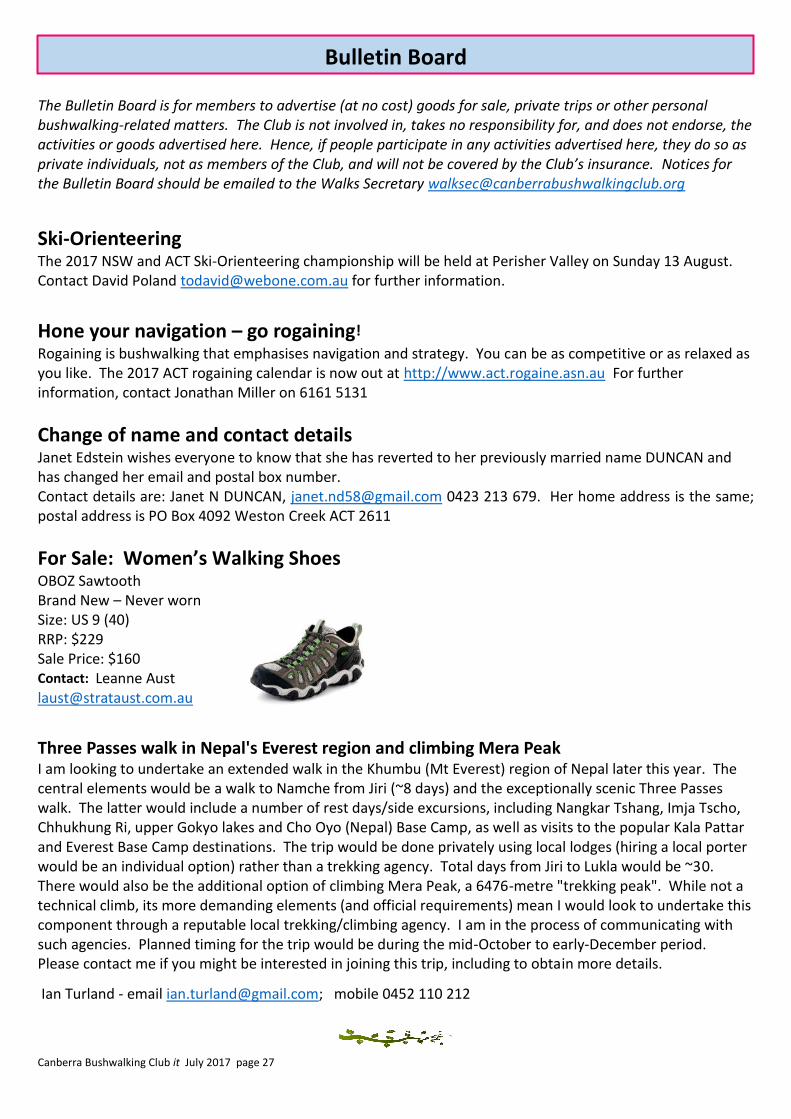
For Sale: Women’s Walking Shoes OBOZ Sawtooth Brand New – Never worn Size: US 9 (40) RRP: $229 Sale Price: $160 Contact: Leanne Aust [email protected]
Three Passes walk in Nepal's Everest region and climbing Mera Peak I am looking to undertake an extended walk in the Khumbu (Mt Everest) region of Nepal later this year. The central elements would be a walk to Namche from Jiri (~8 days) and the exceptionally scenic Three Passes walk. The latter would include a number of rest days/side excursions, including Nangkar Tshang, Imja Tscho, Chhukhung Ri, upper Gokyo lakes and Cho Oyo (Nepal) Base Camp, as well as visits to the popular Kala Pattar and Everest Base Camp destinations. The trip would be done privately using local lodges (hiring a local porter would be an individual option) rather than a trekking agency. Total days from Jiri to Lukla would be ~30. There would also be the additional option of climbing Mera Peak, a 6476-metre "trekking peak". While not a technical climb, its more demanding elements (and official requirements) mean I would look to undertake this component through a reputable local trekking/climbing agency. I am in the process of communicating with such agencies. Planned timing for the trip would be during the mid-October to early-December period. Please contact me if you might be interested in joining this trip, including to obtain more details.
Ian Turland - email [email protected]; mobile 0452 110 212
Bulletin Board