Embed Size (px)
Citation preview

Catalog of Worldwide Test Sites for Sensor CharacterizationCatalog of Worldwide Test Sites for Sensor CharacterizationMarch 18, 2009
Gyanesh Chander GEO Task: DA-09-01a_2 LeadSGT, INC.*, contractor to the U.S. Geological Survey (USGS) Earth Resources Observation and Science (EROS) Center, Sioux Falls, SD*Work performed under USGS contract 08HQCN0005Telephone: 605-594-2554, E-mail: [email protected]

2
OutlineOutline
IntroductionSite Selection CriteriaOnline Test Site catalogCEOS Reference Standard Test SitesSummaryProposed Future Plans

3
ContextContextWith television, weather channels, Google Maps™ mapping service, and other day-to-day uses, satellite imagery has clearly become part of mainstream information society
Nevertheless, for most operational remote sensing applications, critical issues remain with respect to the:
Reliability of supplyConsistent data qualityPlug-and-play capability
Consistent data quality implies the adherence of data to appropriate standards of fidelity to the underlying physical quantities (reflectance, temperature, etc.) that they measure
These well-calibrated data then assure the accuracy and enhance the intercomparability that enables the use of advanced Earth observation technologies to address societal benefits

4
Scope of Test SitesScope of Test Sites
Test sites are central to any future QA/QC strategy
Test sites provide a convenient means of obtaining information to verify sensor performance
Test sites are the only practical means of deriving knowledge of biases between sensors
Test sites allow, at some level, a means of bridging anticipated data gaps caused by lack of measurement continuity, due to lack of co-existent in-flight sensors

5
Need for a Global, Integrated Network of Calibration SitesNeed for a Global, Integrated Network of Calibration Sites
User communities increasingly rely on information products from multiple satellite sensors
Better calibration can result from more postlaunch calibration involving standardized measurement protocols, instrumentation, and processing
Field measurements remain resource-intensive activities
Less expensive complementary approaches can provide more frequent calibration updates and enable the monitoring of sensorperformance trends, even without surface measurements
Future global monitoring systems, using increasingly complex constellations of satellites with multiple sensors, such as the Global Earth Observation System of Systems (GEOSS), will amplifythe need for this initiative to address global societal benefits

6
Characteristics of Sensors which can Benefit from Test Sites Characteristics of Sensors which can Benefit from Test Sites
GainStabilityMTFUniformity (Flat field)Stray light (Adjacency effects)PolarizationSpectralSNRAlgorithms
GeolocationCamera modelBand-to-bandInternal GeometryTemporal effects

7
Well-Established Site Selection Criteria for Radiometry Test SitesWell-Established Site Selection Criteria for Radiometry Test Sites
High spatial uniformity over a large area (within 3%)Minimize misregistration and adjacency effects
Surface reflectance greater than 0.3 To provide higher SNR and reduce uncertainty due to atmosphere
Flat spectral reflectanceReduce uncertainties due to different RSR
Temporally invariant surface properties (within 2%)To reduce BRDF, spectral, surface reflectance effects
Horizontal surface with nearly lambertian reflectanceMinimize uncertainty due to different solar illumination and observation geometry
At high altitude, far from ocean, urban, and industrial areasMinimize aerosol loading and atmospheric water vapor
In arid regions with low probability of cloud coverMinimize precipitation that could change soil moisture

8
Online Test Site CatalogOnline Test Site Catalog
The layout is set up to help the user quickly locate the needed information available on the site
Drop-down menus list locations so the user may go straight to a specific siteA map with clickable links provides another way to go to sitesThe maps include a world map, where the user selects a continent, and a map of each major continent
Each of the calibration site pages contains the same fields for easy review
These fields include location, terrain elevation, center latitude/longitude, WRS-2 path/row, size of usable area, owner, researcher, purpose, description, support data, suitability, and limitations
Other features includeA small image of the globe depicting the position of the siteSatellite images of the test sitePrevious/next button Sample Landsat images and Google KMZ files

9
http://calval.cr.usgs.gov/sites_catalog_map.phphttp://calval.cr.usgs.gov/sites_catalog_map.php

10
Test Sites GalleryTest Sites Gallery
11
Radiometry SitesRadiometry Sites

12
Radiometry SitesRadiometry Sites

13
Online Catalog Example:Railroad Valley Playa, North AmericaOnline Catalog Example:Railroad Valley Playa, North America

14
Online Catalog Example:Libya 4, AfricaOnline Catalog Example:Libya 4, Africa

15
Online Catalog Example:Dunhuang, AsiaOnline Catalog Example:Dunhuang, Asia

16
Online Catalog Example:Amburla, AustraliaOnline Catalog Example:Amburla, Australia

17
Online Catalog Example:La Crau, EuropeOnline Catalog Example:La Crau, Europe

18
Online Catalog Example:Barreal Blanco, South AmericaOnline Catalog Example:Barreal Blanco, South America
19
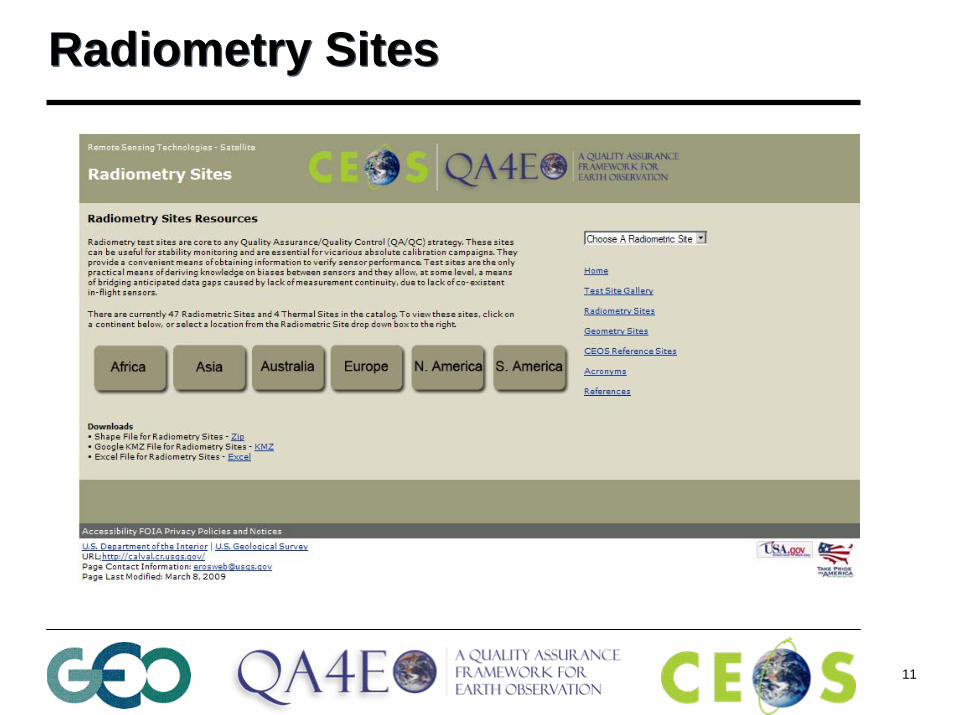
Geometry SitesGeometry Sites

20
Ground Control Points (GCP)Ground Control Points (GCP)
51 GCPs selected over Brookings, SD area
72 GCPs selected over Morrison, CO area

21
AcronymsAcronyms

22
ReferencesReferences

23
CEOS Reference Standard Test SitesCEOS Reference Standard Test SitesThe IVOS sub-group members established a set of CEOS reference standard test sites
Based on the decision from the CEOS IVOS-19 meeting, there are 8 instrumented sites and 5 pseudo-invariant sites

24
CEOS Reference Standard Test SitesCEOS Reference Standard Test SitesThe CEOS instrumented sites are provisionally being called “Landnet”
These instrumented sites are primarily used for field campaigns to obtain radiometric gain and these sites can serve as a focus forinternational efforts, facilitating traceability and cross-comparison to evaluate biases of in-flight and future sensors in a harmonized manner
The pseudo-invariant desert sites have high reflectance and are usually made up of sand dunes with low aerosol loading and practically no vegetation
Consequently, these pseudo-invariant reference standard test sites can be used to evaluate the long-term stability of a sensor and to facilitate cross-comparison of multiple sensors

25
“Instrumented” Sites (Total=8)“Instrumented” Sites (Total=8)
Railroad Valley Lspec La Crau
Dome CTuz GoluNegevDunhuang
Ivanpah

26
“Pseudo-Invariant” Sites (Total=5)“Pseudo-Invariant” Sites (Total=5)
Libya 4Mauritania 1/2Algeria 3Libya 1 Algeria 5
Libya 1Algeria 3
Libya 4 Mauritania 2
Algeria 5

27
Questionnaire for Information Regarding the Cal/Val Test SitesQuestionnaire for Information Regarding the Cal/Val Test Sites

28
La Crau, FranceLa Crau, France

29
SummarySummaryThe test site catalog provides a comprehensive list of prime candidate terrestrial targets for consideration as benchmark sites for the postlaunch radiometric calibration of space-based optical sensors
The online test site catalog provides easy public Web site access to this vital information for the global community
The incompleteness of available information on even these prime test sites is an indication that much more coordination and documentation are still needed to facilitate the wider use of calibration test sites in remote sensing

30
Proposed Future PlansProposed Future PlansGather complete site characterization data and information
Define core measurements (eg. Instruments)Develop protocols and fund pilot projectsCreate an operational network of land sites (“Landnet”)
Encourage agencies to acquire, archive, and provide data to the Cal/Valcommunity over CEOS sites
Use radiometric gain and stability as an immediate priorityDevelop online calibration data access infrastructureCreate tools to identify the potential co-incident image pairs (NASA SEO)
Integrate the catalog into the CEOS EO Cal/Val portal
Establish traceability chain for primary site data & “best practice”guidance on site characterization and its use

31
Back-up SlidesBack-up Slides

32
Radiometry SitesRadiometry Sites

33
Prime Candidate Earth Target TypesPrime Candidate Earth Target TypesIncluding only playa (dry lakebed), salt flat, and desert sand sites
Snow fields are excluded primarily because high surface reflectances are more sensitive to variations in atmospheric particle size distribution and because they are usually located at latitudes characterized by high solar zenith angles
Vegetation targets are excluded because they are subject to phenological changes as well as strong reflectance anisotropy effects
Water targets are excluded because low surface reflectances are more sensitive to atmospheric path radiance and because of sun glint
Other target types (uniform cloud cover, atmospheric scattering, ocean glint) are excluded because more specialized analysis is required, not in keeping with operational use of benchmark test sites

34
Calibration Site CategorizationsCalibration Site CategorizationsAbsolute Calibration (A) - An absolute calibration site is a location where in situ ground measurements of key physical parameters areacquired by calibrated ground instruments, allowing a detailed comparison of the ground instrument results to those of an orbiting sensor
Pseudo-Invariant Calibration (I) - A pseudo-invariant site is a location on the Earth’s surface that is very stable both temporally and spatially over long periods of time and over significant spatial extent. These sites are typically located in desert regions that receive little rainfall and have few surface features
Cross-Calibration (X) - A cross-calibration site is a location on the Earth’s surface that contains large homogeneous regions that are viewable by two or more satellite sensors within a relatively short time period

35
Provisional Calibration Site CategorizationsA=Absolute I=Pseudo-Invariant X=Cross-CalibrationProvisional Calibration Site CategorizationsA=Absolute I=Pseudo-Invariant X=Cross-Calibration

36
Test site as a reference standard!Test site as a reference standard!
For example in the context of radiometric gain: Internal Calibrator, Solar Diffuser, Rayleigh scattering, clouds, sun-glint are all equally applicable methods
Test sites and their use is really a methodology which in turn is one of many potential methods
In that context, test sites become a means to achieve an objective and should really be defined as “reference standards” to facilitate an activity

37
Special MethodsSpecial Methods
Sun glint RayleighMoon
Rayleigh Calibration Sites – Choice of oligotrophic areas with 2 years of SeaWiFS data made in 2001 with ACRI and LOV
(CLIMZOO zones)
Clouds

38
Template for information regarding the CEOS IVOS Cal/Val Test Sites Template for information regarding the CEOS IVOS Cal/Val Test Sites

39
Recommendationsfor
EO missions

40
CEOS WGCV SubgroupsCEOS WGCV Subgroups
WGCV Chair: Dr. Changyong Cao (NOAA/NESDIS)
Infrared and VisibleOptical Systems (IVOS)
Dr. Nigel Fox (NPL)
Terrain Mapping (TMSG)Prof. Jan-Peter Muller (UCL)
Synthetic Aperture Radar (SAR)Dr. Satish Srivastava (CSA)
Microwave Sensors (MSSG)Christopher Buck (ESA)
Land Product Validation (LPV)Dr. Fred Baret (CNES)
Atmospheric Chemistry (AC)Dr. Bojan Bojkov (UMBC/NASA)

41
Terrain Mapping Subgroup (TMSG)Terrain Mapping Subgroup (TMSG)Montagne Sainte-Victoire
France referred to as Aix-en-Provence5.528-5.685ºE, 43.502-43.560ºNmixed arable, forest, limestone
Barcelona, Spain1.5-2.75ºE, 41.25-41.82ºNurban, mixed arable, forest
North Wales, UK3-5ºW, 52-53.5ºNurban, pasture, forest
Three Gorges, China108.252-111.302ºE, 30.638-31.229ºNforest, arable, limstone shales
Puget Sound, WA, USA-121.397 to -123.897ºW, 46.364-48.864ºNforest, urban, wetlands
N.B. screenshots from ICEDS extracts

42
Synthetic Aperture Radar (SAR)Synthetic Aperture Radar (SAR)International Amazon Rainforest Site
A CEOS radiometric calibration reference siteData routinely collected and analyzed for calibration monitoring of SAR satellites including RADARSATsRadiometry of the site remains stable
Canadian Boreal Forest SiteRadiometric characterization completed at C-band using RADARSAT-1 dataSite seasonally dependentCan be used as a complimentary site to the Amazon but with reduced radiometric accuracy
Calibration Transponder Sites

4343
CEOS WGCV 2004UL: - 5.03, - 65.67; LR - 9.12, - 69,64 deg
IsotropyTemporal stabilitySpatial uniformityWell characterizedradiometrically
1978 Seasat (L)1985 SIR-B (L)1991 ERS-1 (C)1992 ERS-2 (C)1994 SIR-C (X)1992 JERS-1 (L)1996 RADARSAT-1 (C)2002 ENVISAT (C)2006 PALSAR (L)2008 RADARSAT-2 (C)
CSA Amazon Data Record: 10 years(1600 RADARSAT-1 acquisitions to date)
SAR Cal/Val Test Site: Amazon RainforestSAR Cal/Val Test Site: Amazon Rainforest

4444
• CSA campaign started Jan 2003• Elevation beam pattern extractions
began Dec 2004 using seasonal γreferences for summer and winter
• Support for prime calibration area (Amazon) with non-OBR, real-time acquisitions
• Allows frequent calibration assessments (higher latitude)
• Used for W2 recalibration in 2006
• CEOS SAR Workshop 2006, "RADARSAT-1 Elevation Beam Pattern Extraction using the Canadian Boreal Forest: Update and Application", S. Cote, P. Le Dantec, T.I. Lukowski, R. K. Hawkins, S. K. Srivastava
EL1 W1 W2 W3 S7
10° 49°
Experimental SAR Cal/Val Test Site: Boreal Forest, CanadaExperimental SAR Cal/Val Test Site: Boreal Forest, Canada
4545
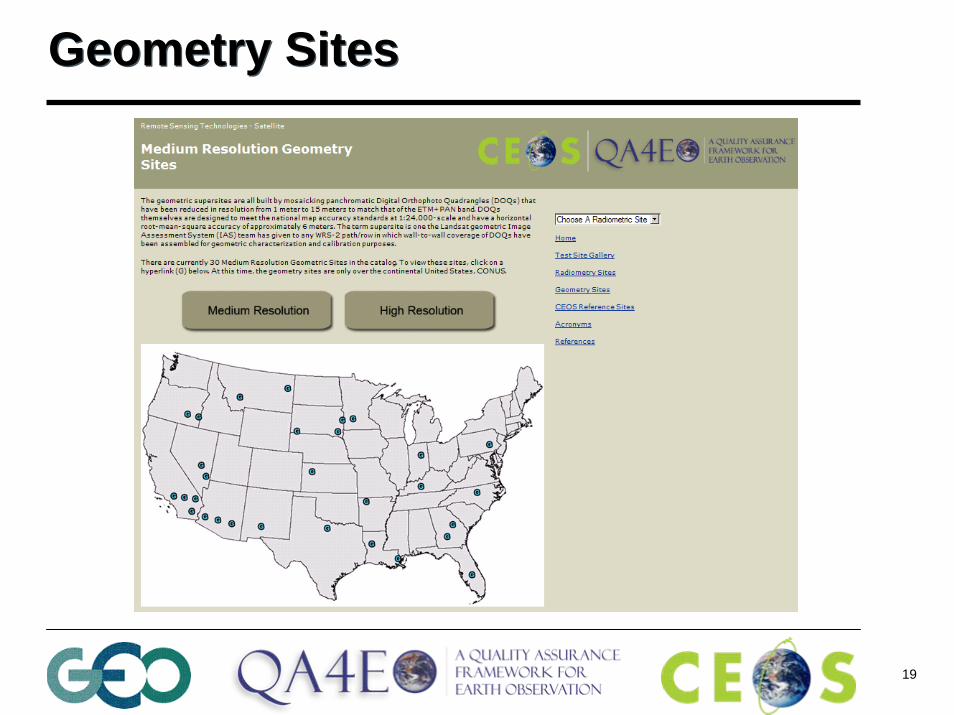
Two potential sites in Canada for inter-sensor comparisons for C-band SARs
(RADARSAT-1, Envisat and RADARSAT-2)
• In Fall 2006, ESA relocated an Envisat ASAR Transponder in Resolute Bay in vicinity of the RADARSAT Transponder
• Both transponders can be used simultaneously by Envisat
RADARSATTransponder
ENVISATTransponder
ENVISAT ASAR Image of Resolute
• Another Envisat ASAR Transponder was relocated in Ottawa in 2007, again in vicinity of a RADARSAT Transponder
Ottawa Site
CSA
ESA
C-Band Transponder Sites in Canada: from CSA-only to CSA/ESA SitesC-Band Transponder Sites in Canada: from CSA-only to CSA/ESA Sites

46
Microwave Sensors Subgroup (MSSG)Microwave Sensors Subgroup (MSSG)
Sandy desert (e.g. Sahara)Deep penetration depth, temporal stability of the Tb, underground structure TBD
Rocky/mixed desert (e.g. Gobi)Shallow penetration depth, azimuthal effects and vegetation
Rainforest (Amazon)Volume scatter, effects of rain cells on the canopy equivalent moisture TBD
Stable ocean areasEffects of the wind/salinity at L-band TBD
AntarcticaDry atmosphere, large penetration depth & temporally stable, low azimuthal anisotropy

47
Land Product Validation (LPV)Land Product Validation (LPV)CEOS Benchmark Land Multisite Analysis and Intercomparison of Products (BELMANIP) - http://lpvs.gsfc.nasa.gov/
Map of sites covered by the groups represented in this paper (given on a global map of dominant surface types in each 1 x 1 cell (bare soil, water bodies, deciduous broadleaf forest, evergreen needleleaf forest,evergreen broadleaf forest, crops, grass)

48
Land Product Validation (LPV)Land Product Validation (LPV)CEOS Benchmark Land Multisite Analysis and Intercomparison of Products (BELMANIP)‘Direct’ sites
No necessity for high spatial homogeneity (non linearity as a function of heterogeneity), but homogeneity at medium resolution (geometrical accuracy, PSF)Flat siteElement of an ensemble to sample different vegetation types and conditionsCurrently about 100 sites identified, but only a fraction with accessible information… List under compilation
‘Intercomparison’ sitesHomogeneity at medium spatial resolutionFlat siteSampling all conditions (BELMANIP accessible at LPV web site, but must be revised)

49
Atmospheric Chemistry (AC)Atmospheric Chemistry (AC)