Embed Size (px)
Citation preview
Case study: Giardini Naxos (Italy) Technique: Artificial reef creation
Location
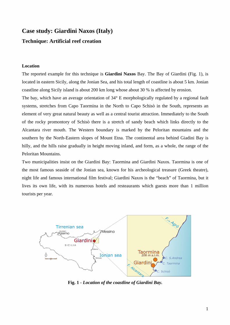
The reported example for this technique is Giardini Naxos Bay. The Bay of Giardini (Fig. 1), is
located in eastern Sicily, along the Jonian Sea, and his total length of coastline is about 5 km. Jonian
coastline along Sicily island is about 200 km long whose about 30 % is affected by erosion.
The bay, which have an average orientation of 34° E morphologically regulated by a regional fault
systems, stretches from Capo Taormina in the North to Capo Schisò in the South, represents an
element of very great natural beauty as well as a central tourist attraction. Immediately to the South
of the rocky promontory of Schisò there is a stretch of sandy beach which links directly to the
Alcantara river mouth. The Western boundary is marked by the Peloritan mountains and the
southern by the North-Eastern slopes of Mount Etna. The continental area behind Giadini Bay is
hilly, and the hills raise gradually in height moving inland, and form, as a whole, the range of the
Peloritan Mountains.
Two municipalities insist on the Giardini Bay: Taormina and Giardini Naxos. Taormina is one of
the most famous seaside of the Jonian sea, known for his archeological treasure (Greek theatre),
night life and famous international film festival; Giardini Naxos is the “beach” of Taormina, but it
lives its own life, with its numerous hotels and resteaurants which guests more than 1 million
tourists per year.
Fig. 1 - Location of the coastline of Giardini Bay.
1

Coastal morphology and dynamics
The area of the Bay of Giardini is confined between Capo Taormina to the North and Capo Schisò
to the South.
Observing the geomorphological characteristics of the two promontories and considering the
geological nature of the area immediately inland, it is possible to note how the Northern area is
completely “isolated” by the contiguous physiographic units (coastal sedimentary cells), while the
Southern area shows a greater “permeability” with respect to sediments transported from the South.
The beach enclosed by the Bay of Giardini Naxos, as we have said, may be considered a “relict”
beach or pocket beach, extending for about 5 km. It may be divided into several parts. These parts
are characterised by the presence of a number of man-made structures realised over the years: the
quay of Schisò, five sub perpendicular groynes, three sub parallel breakwaters and the quay of Saia.
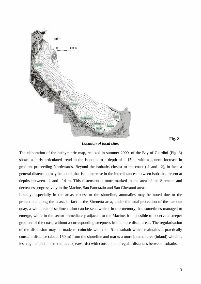
Using both man-made and natural landmarks it is possible to identify the following areas (Fig. 2):
- Schisò Harbour, from the quay built onto the extension of Capo Schisò to the first sub
perpendicular groyne built to the South of the lido della Sirenetta: this represents today’s
Giardini Naxos Harbour.
- Sirenetta, between the two southernmost sub parallel groynes: this offers a widespread sandy
area where the private lidos are situated.
- Macine: between the second and third sub parallel groynes: this represents a flat rocky area,
periodically free of sediment, where it is possible to see traces of the quarrying of millstones for
oil-mills (“macine” in Italian).
- San Pancrazio, between the third and fourth sub perpendicular groynes: an area greatly
deteriorated by the presence of the three sub parallel breakwater barriers.
- San Giovanni, between the fourth and the fifth sub perpendicular groynes, offering a stretch of
beach varying in width, at the centre of which is the mouth of the torrente San Giovanni.
- Municipio (“City Hall”), between the fifth sub perpendicular groynes and the Saia quay: a
barely developed stretch of beach, protected by a number of outcropping rocks
- Villagonia, which falls almost entirely within the territory of the City of Taormina, between
Saia Quay and Capo Taormina: a stretch of pebbly beach, running alongside the railway line,
where at present bathing is forbidden.
2
E3
E3
E3
E3
0 400 m
N
H5
H2
Schisò
SirenettaMacine
San Pancrazio
San Giovanni
Municipio
Villagonia
Fig. 2 – Location of local sites.
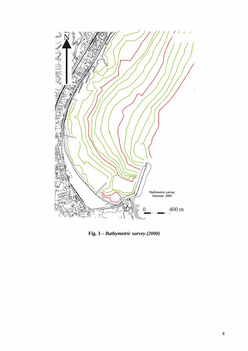
The elaboration of the bathymetric map, realized in summer 2000, of the Bay of Giardini (Fig. 3)
shows a fairly articulated trend in the isobaths to a depth of – 15m., with a general increase in
gradient proceeding Northwards. Beyond the isobaths closest to the coast (-1 and –2), in fact, a
general distension may be noted, that is an increase in the interdistances between isobaths present at
depths between –2 and –14 m. This distension is more marked in the area of the Sirenetta and
decreases progressively in the Macine, San Pancrazio and San Giovanni areas.
Locally, especially in the areas closest to the shoreline, anomalies may be noted due to the
protections along the coast, in fact in the Sirenetta area, under the total protection of the harbour
quay, a wide area of sedimentation can be seen which, in our memory, has sometimes managed to
emerge, while in the sector immediately adjacent to the Macine, it is possible to observe a steeper
gradient of the coast, without a corresponding steepness in the more distal areas. The regularisation
of the distension may be made to coincide with the –5 m isobath which maintains a practically
constant distance (about 150 m) from the shoreline and marks a more internal area (inland) which is
less regular and an external area (seawards) with constant and regular distances between isobaths.
3
N
0 400 m
Fig. 3 – Bathymetric survey (2000)
4
Considering the orography of the area, the site proves to be well protected from North winds and to
a lesser degree from North-East winds, being sheltered from these by the promontory of Capo
Taormina. However the area proves to be exposed to South-Easterly and Easterly winds; the former
are slightly broken by the promontory of Capo Schisò, while the latter sweep into the Bay of
Giardini without meeting with the slightest impediment. Considering the orientation of the coastline
between Capo Taormina and Capo Schisò, which is about 45° N, the dominant East and North-East
winds tend to generate Southward littoral currents within the bay, while the South-Westerly winds,
dominating to a lesser degree, generate Northward currents.
The measurements used in order to examine the wind regime were those carried out between 1959
and 1991 at the Catania – Fontanarossa Airport Observatory 1.
The direction is indicated with reference to the eight points of the compass with the name of the
cardinal point from which the wind is blowing (N, NE, E, SE, S, SW, W, NW); the speed is
attributed to the direction noted at the time of observation and, when measured as less than 2 knots,
the mode observed is classified as “calm”.
The measurement of the wind is carried out at least every six hours (7 a.m., 1 p.m. and 7 p.m. or 8
a.m., 2 p.m. and 7 p.m.) so that the frequency of the different modes of wind is expressed on the
basis of the effective number of observations (for example, if three readings are taken per day, the
total number of frequencies in a year is 1095, that is 3 readings for 365 days).
Since for the shoreline North of Catania it is the long-term evolution that is interesting, average
annual values of wind speed were considered, registering for each direction of origin the
frequencies of occurrence and the speed expressed in knots.
There are no specific studies of the area, while the entire coastline of Sicily is considered a
patchwork of pieces which show a differential movement related to the local tectonic activity.
About underwashing activity we can say that in general in the bay of Giardini it was evident in the
last decades a sediment shifting towards South. In the past, the dynamic equilibrium of the beach
was determined by the alternative driving forces due, respectively, to the SE winds which moved
northward the sediments of the beaches (emerged and submerged) and to the NE winds which
moved the sediments southward. The never ended construction of the Schisò Harbours has stopped
the northward movement of the material, limiting the transport of the sediments only southward.
1under the management of the ANAV (National Flying Assistance Company), situated at 16 m. a.s.l., latitude North 37° 28’ and longitude (Monte Mario) 2°37’ E. The data, published in the ISTAT (Italian Institute of Statistics) Weather Report, indicate for each principal direction of the wind rose the frequency of occurrence, the average speed calculated for each month of the year and the frequency of calms.
5
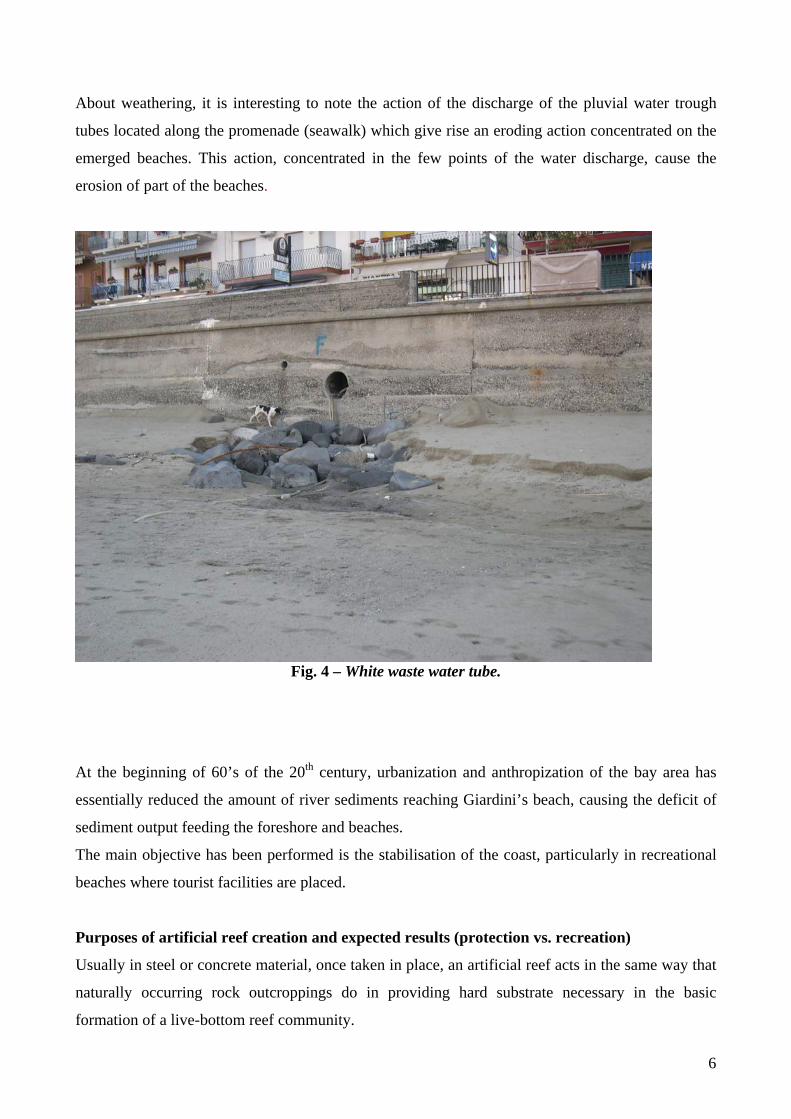
About weathering, it is interesting to note the action of the discharge of the pluvial water trough
tubes located along the promenade (seawalk) which give rise an eroding action concentrated on the
emerged beaches. This action, concentrated in the few points of the water discharge, cause the
erosion of part of the beaches.
Fig. 4 – White waste water tube.
At the beginning of 60’s of the 20th century, urbanization and anthropization of the bay area has
essentially reduced the amount of river sediments reaching Giardini’s beach, causing the deficit of
sediment output feeding the foreshore and beaches.
The main objective has been performed is the stabilisation of the coast, particularly in recreational
beaches where tourist facilities are placed.
Purposes of artificial reef creation and expected results (protection vs. recreation)
Usually in steel or concrete material, once taken in place, an artificial reef acts in the same way that
naturally occurring rock outcroppings do in providing hard substrate necessary in the basic
formation of a live-bottom reef community.
6

Designed reef habitat units of various shapes and sizes are currently being tested at many nearshore
and offshore locations. These designs incorporate standard construction materials such as steel,
concrete and some heavy-duty plastics.
Many materials such as concrete pipe, concrete pilings, steel highway bridges and a variety of other
bulky structures are often re-utilised as substrate in the construction of artificial reefs.
Basic principles
Reef breakwaters are coast-parallel, long or short submerged structures built, with the objective of
reducing wave action on the beaches by forcing wave breaking over the reef breakwater.
Building an artificial reef could providing a natural habitat for marine biodiversity , and an
opportunities for recreational activities.
Emerged offshore breakwaters are protective structures of a rigid type but with active replenishing
effects; they have the function of damping down the energy of the waves and therefore of creating
on their landward side an area of “shadow” or “calm waters”. These measures too are not without
their risks: there is the risk of downdrift erosion; of the formation of banks of fine-grained
sediments and therefore with the phenomena of clouding; and the relative problems, for the
environment and for exploitation, of stagnation of the waters between the barrier and the shore, with
a corresponding risk of pollution and eutrophisation, and of deterioration of the landscape. All of
these risks can be avoided, or significantly reduced, if the barriers are of the submerged type.
The emergent barrier, moreover, although suitable in theory for preventing erosive processes
already under way, must be rejected for its very high negative impact on the landscape. It would
indeed make it possible to achieve the functional objectives (of protecting houses and the road) but
it would do so destroying in a virtually permanent way all the attractiveness of the beach for tourists
and holiday-makers; it would also increase the use of stone material, adding to the impact on the
environment “transferred” to the quarry areas and those deriving from its transport, with a
considerable increase in costs.
The submerged barrier acts as a physical operator, dissipating and damping down the energy of the
wave movement, respecting the shape of the local shoreline in its pre-erosive form and protecting
the addition of granular material suitable for reconstructing the emerged and submerged beach.
The presence of such a barrier is a physical encouragement for the profile of the beach to reform
with a generally more gentle gradient than that naturally assumed; it also leads granulometric
fractions, which otherwise would have been lost out at sea, to become stable in water. It does not
7
create any negative visual impact on the coastal landscape, and it may constitute an ideal habitat for
local marine fauna.
Expected benefits
For Giardini Naxos Bay expected benefits can be quantified as follow:
- protection of the shore
- enlargement of the beach
- regulation of sedimentation
- dissipation of wave energy
- allow deposition of drift material behind the breakwater
Environmental benefits
Those are related here for benefits on erosion control, modifying the slope of the shoreface and thus
acting over the incident wave trains by diminishing their energy (especially in stormy periods).
Social and economical benefits
The welfare of an island like Sicily, whose economy depends largely on the tourist industry,
depends to a great extent on the quality of the beaches.
The aim is to remove the causes of deterioration and/or erosion in coastal areas, by means of “the
restoration of the natural conditions which have led to the formation of the shoreline, with particular
reference also to building activities inland, to the recovery and restitution to their natural state of the
wet and dry river courses and to the restoration of the solid littoral transport; particular attention is
to be paid also to the effects on an increase in tourist potential, the recovery of state property and
the protection of private and public goods from sea storms”.
In the last ten years there has been a continuous positive trend of presences of tourists, either in
hotels or in extra hotel structures (Tab. 1and 2).
8

Tab. 1 - Presence of Italian and Foreign tourists in the years1990 – 2001 in hotels.
Years It.arrivals It. presences For. Arriv. For. presences Total arriv. Total presences1990 57795 229931 51538 311504 109333 541435 1991 59991 229188 59541 351622 119532 580810 1992 56659 205448 48400 246292 105059 451740 1993 60184 223932 32750 181289 92934 405221 1994 73317 262121 57643 286410 130960 548531 1995 81513 310055 84567 381924 166080 691979 1996 91002 379314 96184 483196 187186 862510 1997 92126 360773 102296 479922 194422 840695 1998 88885 347011 104512 467874 193397 814885 1999 88393 352975 102237 483730 190630 836705 2000 85387 338909 109227 509756 194614 848665 2001 96295 372635 126646 565302 222941 937937
Tab. 2 - Presence of Italian and Foreign tourists in the years1990 – 2001 in extra hotel structures. Years It.arrivals It. presences For. Arriv. For. presences Total arriv. Total presences1990 429 1934 249 1004 678 2938 1991 289 1123 427 2615 716 3738 1992 194 994 121 444 315 1438 1993 187 1019 66 1004 253 2023 1994 277 1367 70 359 347 1726 1995 252 1257 210 1157 462 2414 1996 326 1288 247 1438 573 2726 1997 270 1255 209 1161 479 2416 1998 282 1483 287 1611 569 3094 1999 239 1243 367 2422 606 3665 2000 3858 17289 4745 35558 8603 52847 2001 5225 19757 7768 55835 12993 75592
Technical and financial benefits
About technical benefits the intervention of the reef creation with the beach nourishment is focused
to get a width accretion of the beach of about 50 m for about 850 m for Sicilian case. At the end of
the intervention there will be an unique public beach instead of many little stretch of beaches
interrupted by groynes.
9
Designing artificial reef scheme step-by-step
To get a clear, integrated and complete idea of the entire protection intervention, it may be useful to
go back over each stage of the realisation of a coastal defence construction, including also the
moments prior to planning, those of execution (even if only in synthesis) and those of management.
Basically it is possible to summarize the “order of procedures” as follows:
• defining the objectives of the project (non-technical as well as strictly technical);
• establishing the surrounding conditions and the limits imposed in planning;
• carrying out preliminary studies (determining the state of the coastal environment);
• defining all the possible planning options in conformity with the already defined objectives,
surrounding conditions and limits;
• examining the various options and if possible ways to optimize them (with the help of
models)
• comparing the options prior to making a choice (on the basis of a “costs-benefits” analysis
involving such aspects as seaside tourism and sea-bathing, the landscape, as well as social and
environmental considerations);
• executive planning of the works to be carried out and drawing up of a maintenance program
(with the help of models)
• building (monitoring the building activity step by step); implementing the completed work
and subsequently managing it (by this we intend enjoyment of the protected good associated
with monitoring and maintenance of the protection works, in conformity with the pre-
established parameters)
The adequate sediment characteristics were determined, about granulometry, using the JAMES
1975 ratios, while the compositional compatibility was determined using the mineralogical analysis,
performed counting 300 grains of sand under the binocular microscope, and comparing the data
from the source of material and the sand present on the beach. Finally also the chromatic
compatibility was determined using the Mansell’s table.
The adequate sediment source for beach nourishment was found in two parts of the southern sector
of the Bay.
Potentially, if all the sediment trapped in the south part of the bay should be available to be taken,
there should be about 1.000.000 cm³ of material. All this material is not available because part of
this sediments are now used to bring on land the boats.
10
In the submerged area of the port there is about 100.000 cm³ of material available to be dredged and
placed on the beach.
Another source of material for about 70.000 cm³ is present to the north of the dam of the port in
correspondence with the isobaths of – 10 and – 12 m.
Selecting the adequate artificial reef techniques
Establishing environmental mitigation strategies
In the area the intervention itself is a mitigation strategy.
A prefabricated erosion prevention (P.E.P.) reef was installed during the summer months of 1992
and 1993, at the Town of Palm Beach in Palm Beach County, Florida. The reef was constructed at
the Midtown segment of the Palm Beach Shore Protection Project. The structure consists of 330
interlocking wedge-shaped concrete modules placed approximately 76 m (250 ft) offshore, in 2.9 m
(9.4 ft) of water. The total length of the structure is 1,273 m (4,176 ft), including a 66-m (216-ft)
gap near the north end for a submerged cable easement. The purpose of the structure is to reduce
incident wave energy, allowing accretion of sediment in the lee of the structure.
P.E.P. reef module
Length. 12 ft Width 15 ft. Height 6 Concrete 5000P.S.I. Reinforced Approx. ...................... Weight 50,000 Ibs.
Assessing and monitoring the environmental and social indicators for artificial reef creation
schemes
Over recent years several stretches of the coast of Giardini have been victims of an intense erosive
activity, caused and aggravated by a series of man-made constructions: within the hydrographical
basin (check dams); along the coast (subparallel breakwater barriers); or directly at sea (harbour
quays).
The seafront has withdrawn considerably, with the result that important stretches of the coastal road
have been damaged. These stretches of road have been replaced and temporarily protected with
breakwater barriers and shoreline defences, which in turn have had a very negative environmental
11

impact because, while protecting a few dozen metres of coastline, they have accelerated the erosion
of neighbouring areas.
The erosive process is also favoured by a general reduction in transported solid load, due to a series
of factors (some of them common to most of the shorelines of Italy).
Impact on shoreline stability
Comparing the maps of 1938, 1967, 1972 and 1984 for Giardini case, it is possible to define an
area, stretching from south of the Sirina torrent as far as Capo Schisò, where the increase in
urbanisation, seafront building and the new hard protection structures, have together led to the
erosion of the Northern sector (San Pancrazio) and the progressive advancement of the beach in the
area protected by the harbour structure.
For example, in the years between 1967 and 1972, the beach was decreased about 5 meters each
year, along Northern sector of Sirina area.
In the more Northern part, the seawall erected to protect the railway line initially led to a severe
erosive phenomenon, later stabilising naturally, probably because of the characteristics of the
seabed. In fact the beach at first found a new balance along the direction of the foot of the roadbed
supporting the railway line, but then it became more stable thanks to the presence of natural rocks
which created more protected areas.
Impact on natural habitats
The agriculture is almost absent in Giardini area, only some little cultivation of gardens for a very
limited production of vegetables is still present.
In the paste the whole territory was covered by cultivation of citrus fruits (lemons, oranges) from
where the name of the town derives: Giardini indicates the place where the citrus fruits are
cultivated.
The last extensive cultivation of citrus fruits was present in the area of Recanati, in the south of the
municipal territory, where the cultivation were replaced by private houses and hotels in late ’70.
Woods are completely absent.
The fishery fleet is constituted by less than hundred little boats used for local fishing, above all in
the spring – summer time.
Impact on coastal fauna
Very rare, we think that the reef barrier should give calmer water for nursery and it should favour
the grooving of fishes and mussels.
12

Social perception
Giardini’s town area is of about 5.4 km².
The 60% of this area is urbanized. The remaining 40% is constituted by marginal lands rich in
slopes of hills and drains.
The town of Giardini Naxos is placed almost in the middle between Catania and Messina (the two
greater cities of Sicily).
In Giardini Naxos take place also an important and very beautiful rail station.
The tourism is the most important incoming source (Giardini Naxos area hold 34 hotels and a lot of
recreation places).
It should be carefully considered the possibility to realize to ports in the area.
For the development of the bay it is of primary importance the soft protection of the beach and the
reconstruction of an sustainable panorama (a long golden beach without groins and breakwaters),
then it is necessary to include in the system a port structures.
It should be also possible to realize two ports, in the north area a tourist one and in the south area a
commercial one (where also the cruise boat can dock), but in this case there is the need of a
synergetic development which should include the dialogue between the municipalities of Giardini –
Naxos and of Taormina. Here there is the conflict.
Both on the base of questionnaires previously performed and on the observation of the people, the
social perception is very positive.
Impact on water quality
There is not a special water management policy. The sewerage is collected and treated.
The groundwater of the Alcantara river basin give drinking water to the area.
Impact on water turbidity
About the sediment management, until a couple of years ago, the municipality, in June, took the
sand in filled in the port of Schisò (in the south of the bay) and displaced it along the beaches of the
bay.
The sand was stable for two – three months and with the first storms of September – October was
eroded and slowly moved again toward the port.
From this year the Municipality decide a more radical intervention with the possibility to have a
more stable beach.
At the end of the intervention, after one week the turbidity was absent (pictures available).
13
Impact on pollutant concentration
None water pollution is recorded about Giardini case.
Budgeting artificial reef schemes
Feasibility costs
About 3.500.000 € are the established costs for Giardini case.
Environmental mitigation costs
No environmental mitigation cost has been registered for Giardini Naxos’ defence work.
Investment and engineering costs
About 250.000 € are invested in Giardini Naxos’ project.
Maintenance and monitoring costs
Costs for the maintenance and monitoring the defence work at Giardini Bay is about of 100.000 €.
Limitations
The intervention can be performed only after a study of the area and it has given a very good result
also because it was placed inside a very closed bay.
14