Embed Size (px)
Citation preview

CASE STUDIES IN CONNECTIVITY CONSERVATIONGlobal Innovations in Corridor Identification, Protection, and Restoration
GLOBAL INNOVATIONS IN CORRIDOR IDENTIFICATION, PROTECTION, AND RESTORATIONPrepared and researched by Kyle LucasThis snapshot report provides a series of case studies on the conservation and restoration of corridors worldwide. Ultimately, this report seeks to provide an overview of actions and interventions to improve landscape connectivity based on current literature and corridor preservation projects and the types of solutions being applied to maintain them.
Cover © Richard Barrett / WWF-UK
Inside cover © WWF-Malaysia
WWF
CONTENTSIDENTIFICATION AND DESIGN 1
BOTTLENECKS 13
MONITORING 21
IMPLEMENTATION 27
BIBLIOGRAPHY 48
Acknowledgements: This report was developed following the Landscape Connectivity Workshop held at and hosted by WWF India, Delhi in May 2018. We are grateful to the following people who provided valuable input, facilitation and compilation of notes throughout and following the workshop: Hamsini Bijlani, Dipankar Ghose (WWF India), Nilanga Jayasinghe (WWF US), Nitin Seker (WWF India), Indira Akoijam (WWF India), Thu Ba Huynh (WWF Tigers Alive).
Suggested citation: WWF Tigers Alive (2020). Landscape Connectivity Science and Practice: Ways forward for large ranging species and their landscapes. Workshop Report, WWF Tigers Alive, WWF International.
Workshop report editors: Ashley Brooks (WWF Tigers Alive), Hamsini Bijlani.
Case study report researcher and author: Kyle Lukas
Report prepared by: WWF Tigers Alive.
Published in: 2020 by WWF – World Wide Fund for Nature (Formerly World Wildlife Fund), Gland, Switzerland. Any reproduction in full or in part must mention the title and credit the above-mentioned publisher as the copyright owner.
For more information please contact: Ashley Brooks. [email protected]
WWF Tigers Alive is an initiative of WWF that supports tiger range countries achieve their commitments under the Global Tiger Recovery Program to double the number of tigers by 2022.
WWF is one of the world’s largest and most experienced independent conservation organizations, with over 5 million supporters and a global network active in more than 100 countries. WWF’s mission is to stop the degradation of the planet’s natural environment and to build a future in which humans live in harmony with nature, by: conserving the world’s biological diversity, ensuring that the use of renewable natural resources is sustainable, and promoting the reduction of pollution and wasteful consumption. The designation of geographical entities in this report and the presentation of material, do not imply the expression of any opinion whatsoever on the part of WWF concerning the legal status of any country, territory, or area, or its authorities, or concerning the delimitation of its frontiers or boundaries.
© Richard Barrett / WWF-UK
WWF 1
IDENTIFICATION AND DESIGN

3WWF
NAME, TITLE WWF INTERNATIONAL
USE OF RESOURCE SELECTION FUNCTIONS TO IDENTIFY CONSERVATION CORRIDORS
LOCATION Canmore region of the Bow River Valley & Crowsnest Pass in Crowsnest River Valley (Canada)
OBJECTIVE To provide information on improving corridor planning for large carnivores in Canmore and Crowsnest to local wildlife managers and conservation organizations
METHODS GPS radio collars; MODIS data; Landsat TM imagery; digital elevation models; ArcGIS 9.0; resource selection functions (RSFs) with least-cost modelling
PUBLICATION AUTHORS Cheryl-Lesley B. Chetkiewicz and Mark S. Boyce
Conclusions from Study• Seasonal models were developed in Canmore from a total
of 10,643 GPS locations for grizzly bears and from a total of 4,845 GPS locations for cougars
• Seasonal models were developed in Crowsnest Pass from a total of 6,643 GPS locations for grizzly bears and from a total of 5,741 GPS locations for cougars
• Eighteen least-cost pathways and eight least-cost pathways were identified as potential corridor locations for grizzly bears and cougars in Canmore respectively
• Nineteen least-cost pathways and eight least-cost pathways were identified as potential corridor locations for grizzly bears and cougars in Crowsnest, respectively
DiscussionThis case study is an example of an on-ground approach to identify wildlife corridors. By using RSFs developed from GPS telemetry data, the seasonal distributions of the two species was predicted. Least-cost pathway analyses were then applied to identify potential corridors in the two fragmented landscapes. The data was used to identify corridors in the landscape that could support both species and identify potential highway crossing zones that both species could utilize.
This case study demonstrates a quantitative and repeatable way to identify potential corridors for conservation. The method of using RSF and least-cost pathway models can be applied to other multi-species landscapes to develop guidelines for corridors. This method also identifies the challenges associated with corridor design given that while the two species in this study are both large carnivores that share the same landscape, corridor identification can still vary between the two species based on the season.
Resources for Further Information• Cheryl-Lesley B. Chetkiewicz & Mark S. Boyce. (2009). Use
of resource selection functions to identify conservation corridors.
SPRING
SUMMER
AUTUMN
Predicted probability of grizzly bear occurrence in the Canmore (Source: Cheryl-Lesley, 2009)
IDENTIFICATION AND DESIGN
© Eileen Johnson
5WWF
NAME, TITLE WWF INTERNATIONAL
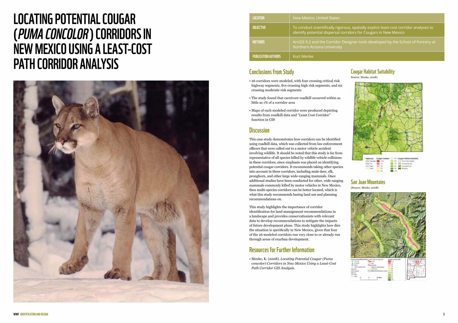
LOCATING POTENTIAL COUGAR (PUMA CONCOLOR ) CORRIDORS IN NEW MEXICO USING A LEAST-COST PATH CORRIDOR ANALYSIS
Cougar Habitat Suitability Source: Menke, 2008)
San Juan Mountains (Source: Menke, 2008)
LOCATION New Mexico, United States
OBJECTIVE To conduct scientifically rigorous, spatially explicit least-cost corridor analyses to identify potential dispersal corridors for Cougars in New Mexico
METHODS ArcGIS 9.2 and the Corridor Designer tools developed by the School of Forestry at Northern Arizona University
PUBLICATION AUTHORS Kurt Menke
Conclusions from Study• 26 corridors were modeled, with four crossing critical risk
highway segments, five crossing high risk segments, and six crossing moderate risk segments
• The study found that carnivore roadkill occurred within as little as 1% of a corridor area
• Maps of each modeled corridor were produced depicting results from roadkill data and “Least Cost Corridor” function in GIS
DiscussionThis case study demonstrates how corridors can be identified using roadkill data, which was collected from law enforcement officers that were called out to a motor vehicle accident involving wildlife. It should be noted that this study is far from representative of all species killed by wildlife vehicle collisions in these corridors, since emphasis was placed on identifying potential cougar corridors. It recommends taking other species into account in these corridors, including mule deer, elk, pronghorn, and other large wide-ranging mammals. Once additional studies have been conducted for other, wide ranging mammals commonly killed by motor vehicles in New Mexico, then multi-species corridors can be better located, which is what this study recommends basing land use and planning recommendations on.
This study highlights the importance of corridor identification for land management recommendations in a landscape and provides conservationists with relevant data to develop recommendations to mitigate the impacts of future development plans. This study highlights how dire the situation is specifically in New Mexico, given that four of the 26 modeled corridors run very close to or already run through areas of exurban development.
Resources for Further Information• Menke, K. (2008). Locating Potential Cougar (Puma
concolor) Corridors in New Mexico Using a Least-Cost Path Corridor GIS Analysis.
IDENTIFICATION AND DESIGN
© Klein & Hubert / WWF
7WWF
NAME, TITLE WWF INTERNATIONAL
IDENTIFYING CORRIDORS AMONG LARGE PROTECTED AREAS IN THE UNITED STATES
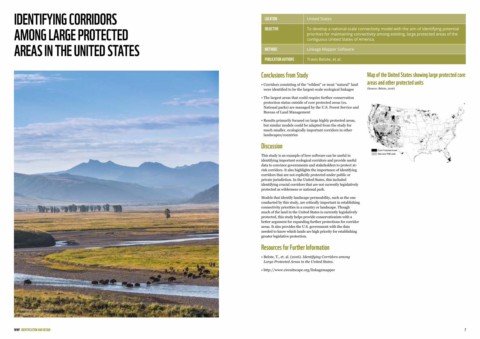
Map of the United States showing large protected core areas and other protected units(Source: Belote, 2016)
LOCATION United States
OBJECTIVE To develop a national-scale connectivity model with the aim of identifying potential priorities for maintaining connectivity among existing, large protected areas of the contiguous United States of America.
METHODS Linkage Mapper Software
PUBLICATION AUTHORS Travis Belote, et al.
Conclusions from Study• Corridors consisting of the “wildest” or most “natural” land
were identified to be the largest-scale ecological linkages
• The largest areas that could require further conservation protection status outside of core protected areas (ex. National parks) are managed by the U.S. Forest Service and Bureau of Land Management
• Results primarily focused on large highly protected areas, but similar models could be adapted from the study for much smaller, ecologically important corridors in other landscapes/countries
DiscussionThis study is an example of how software can be useful in identifying important ecological corridors and provide useful data to convince governments and stakeholders to protect at-risk corridors. It also highlights the importance of identifying corridors that are not explicitly protected under public or private jurisdiction. In the United States, this included identifying crucial corridors that are not currently legislatively protected as wilderness or national park.
Models that identify landscape permeability, such as the one conducted by this study, are critically important in establishing connectivity priorities in a country or landscape. Though much of the land in the United States is currently legislatively protected, this study helps provide conservationists with a better argument for expanding further protections for corridor areas. It also provides the U.S. government with the data needed to know which lands are high priority for establishing greater legislative protection.
Resources for Further Information• Belote, T., et. al. (2016). Identifying Corridors among
Large Protected Areas in the United States.
• http://www.circuitscape.org/linkagemapper
IDENTIFICATION AND DESIGN
© Thomas Szajner / WWF-US

9WWF
NAME, TITLE WWF INTERNATIONAL
NEW ZEALAND FOREST BONDS
Hauraki Gulf, New Zealand (Source: Map of New Zealand, 2009)
LOCATION Hauraki Gulf, Auckland
OBJECTIVE To fund the planting of permanent native forests in Auckland’s Hauraki Gulf and elsewhere in the country through proposed bonds in order to investigate whether “impact investment” could be used to provide up-front capital for permanent forest planting, particularly on vulnerable, erosion-prone land, waterway margins, and in other places throughout the country.
METHODS Use the funding provided from Foundation North’s Gulf Innovation Fund Together (GIFT) for investment in native forest planting that will not only benefit the environment, but also society as a whole.
PUBLICATION AUTHORS Sam Lindsay and Dr. David Hall
Summary of Project• Impact investment bond funding involves gaining a financial
return from the planting of native forests, in addition to a measurable benefit for society and the environment
• The two researchers are looking at how the funding mechanism from the $50,000 grant will work, and it is only second time this approach is being used globally
• Two potential reforestation locations are being explored along the Hauraki Gulf, with an additional goal of bringing together community groups to run the projects
DiscussionThis project proposed by New Zealand researchers demonstrates the potential of using bonds to fund forestry initiatives in New Zealand and around the world. Bonds are used very commonly in some sectors, including health and energy, but due to the need for adapting to climate change, bonds are increasingly being used to finance forests. There is a in New Zealand need to increase native forests, which and is something Dr. Hall discusses in the Pure Advantage 2016 report, “Our Forest Future”. The report argued that New Zealand needs to plant around 1.3 million new hectares of forest in order to help the country’s environment and economy. It also contained an argument for planting blocks of permanent native forest and fresh high-carbon commercial forests to avoid loss of land to erosion, to help offset agricultural emissions, and to help put the country on the path towards a future with net-zero greenhouse gas emissions.
Forest bonds also have a lot of potential economic benefits to be explored and are a big reason why they are increasing in use. A recent report conducted by Wellington’s Motu Economic and Public Policy Research found that the planting of native forests is an effective way to decrease the risk for high-carbon emitting companies.
Resources for Further Information• Morton, Jamie. “Project explores bond to fund new
permanent native forests.” New Zealand Herald [Auckland] 22 October, 2017. nzherald.co.nz. Web. Accessed 30 March, 2018.
North Island
Hauraki Gulf
South Island
IDENTIFICATION AND DESIGN
© WWF / James Morgan
11WWF
NAME, TITLE WWF INTERNATIONAL
TECHNICAL STUDY ON LAND USE AND TENURE OPTIONS AND STATUS OF WILDLIFE CORRIDORS IN TANZANIA
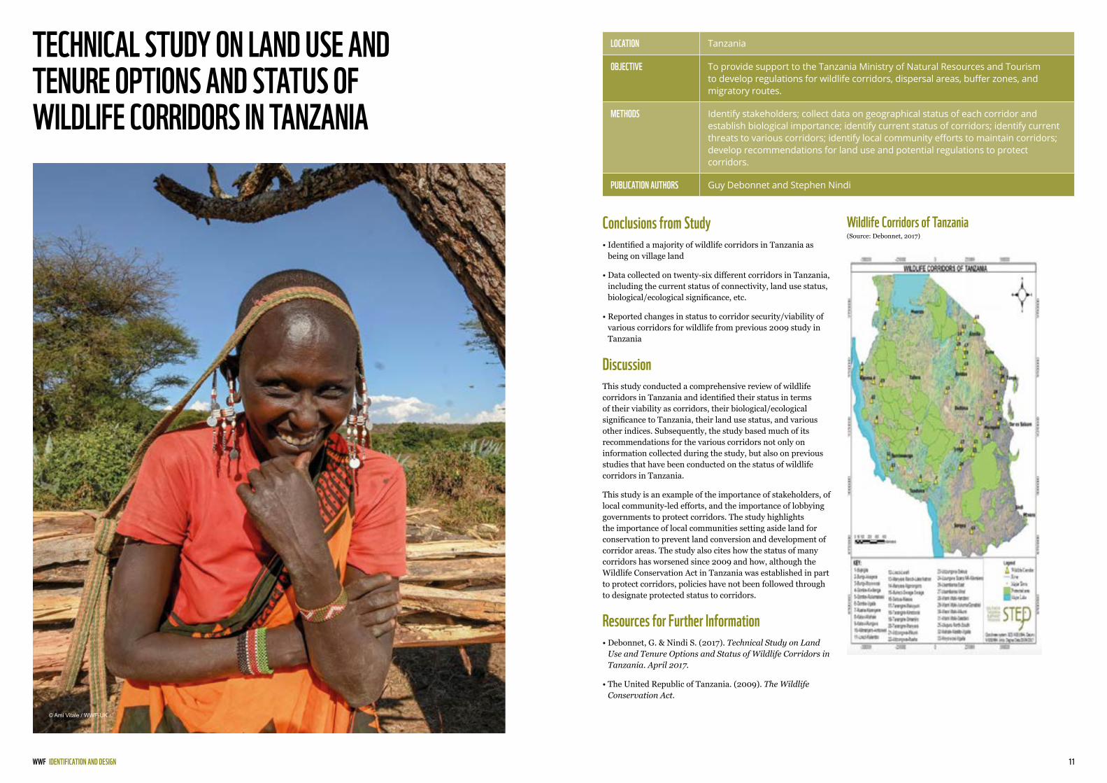
Wildlife Corridors of Tanzania (Source: Debonnet, 2017)
LOCATION Tanzania
OBJECTIVE To provide support to the Tanzania Ministry of Natural Resources and Tourism to develop regulations for wildlife corridors, dispersal areas, buffer zones, and migratory routes.
METHODS Identify stakeholders; collect data on geographical status of each corridor and establish biological importance; identify current status of corridors; identify current threats to various corridors; identify local community efforts to maintain corridors; develop recommendations for land use and potential regulations to protect corridors.
PUBLICATION AUTHORS Guy Debonnet and Stephen Nindi
Conclusions from Study• Identified a majority of wildlife corridors in Tanzania as
being on village land
• Data collected on twenty-six different corridors in Tanzania, including the current status of connectivity, land use status, biological/ecological significance, etc.
• Reported changes in status to corridor security/viability of various corridors for wildlife from previous 2009 study in Tanzania
DiscussionThis study conducted a comprehensive review of wildlife corridors in Tanzania and identified their status in terms of their viability as corridors, their biological/ecological significance to Tanzania, their land use status, and various other indices. Subsequently, the study based much of its recommendations for the various corridors not only on information collected during the study, but also on previous studies that have been conducted on the status of wildlife corridors in Tanzania.
This study is an example of the importance of stakeholders, of local community-led efforts, and the importance of lobbying governments to protect corridors. The study highlights the importance of local communities setting aside land for conservation to prevent land conversion and development of corridor areas. The study also cites how the status of many corridors has worsened since 2009 and how, although the Wildlife Conservation Act in Tanzania was established in part to protect corridors, policies have not been followed through to designate protected status to corridors.
Resources for Further Information• Debonnet, G. & Nindi S. (2017). Technical Study on Land
Use and Tenure Options and Status of Wildlife Corridors in Tanzania. April 2017.
• The United Republic of Tanzania. (2009). The Wildlife Conservation Act.
IDENTIFICATION AND DESIGN
© Ami Vitale / WWF-UK
WWF 13
BOTTLENECKS
BOTTLENECKS
© NACSO/WWF in Namibia

15WWF
NAME, TITLE WWF INTERNATIONAL
CONNECTIVITY AND BOTTLENECKS IN A MIGRATORY WILDEBEEST (CONNOCHAETES TAURINUS ) POPULATION
Adult wildebeest captured on two occasions(Source: Morrison, 2014)
LOCATION Rift Valley, Northern Tanzania
OBJECTIVE To use non-invasive photographic identification of 834 adult wildebeest from 8,530 images collected over four years to characterize patterns of migratory connectivity throughout the northern Tarangire-Manyara Ecosystem, Tanzania.
METHODS Photographic capture-recapture surveys in six sampling areas; identification of individual wildebeests by stripe pattern; identification of bottlenecks through landscape features in satellite imagery and previous accounts of wildlife movements.
PUBLICATION AUTHORS Thomas A. Morrison and Douglas T. Bolger
Summary of Project• 8,530 high-quality images of 5,682 individual wildebeest
were collected during the study
• One-way seasonal movement of 133.1 km by an adult male was observed
• Identified three evident bottlenecks along the migratory pathway
DiscussionThis case study shows the importance of preserving bottlenecks for the long-term sustainability of migratory paths of wildlife and highlights the importance of sustaining the identified bottlenecks for wildebeest between Tarangire and Lake Manyara National Parks and the shoreline of Lake Natron. This migratory path allows the wildebeest to avoid human settlements and steep, rocky topography that constrains the wildebeests’ path to the identified bottlenecks. Additionally, this study highlights the importance of maintaining connectivity to the habitat ranges through the bottlenecks by identifying key resources used by the wildebeest. Specifically, it identifies how there is no permanent water supply in most of the Northern Plains area of their migratory path and how the Northern Plains provide seasonal, high-quality forage for migratory ungulates during the wet season.
The study also identifies examples of population declines due to the loss of seasonal ranges in migratory systems. One such example identified is in Etosha and Kruger National Parks in southern Africa where the wildebeest population declined 85 and 87%, respectively, due to the fencing of the parks. It also identified another case in the Kalahari where the wildebeest population declined by the tens of thousands after wildlife-proof veterinary fences were installed and from the impacts of drought.
Resources for Further Information• Morrison, T. & Bolger, D. (2014). Connectivity and bottlenecks in a migratory wildebeest Connochaetes taurinus population.
Migratory connectivity within the northern portion of the Tarangire-Manyara Ecosystem (Source: Morrison, 2014)
BOTTLENECKS
© Martin Harvey / WWF
17WWF
NAME, TITLE WWF INTERNATIONAL
CHARACTERISING LANDSCAPE CONNECTIVITY FOR CONSERVATION PLANNING USING A DISPERSAL GUILD APPROACH
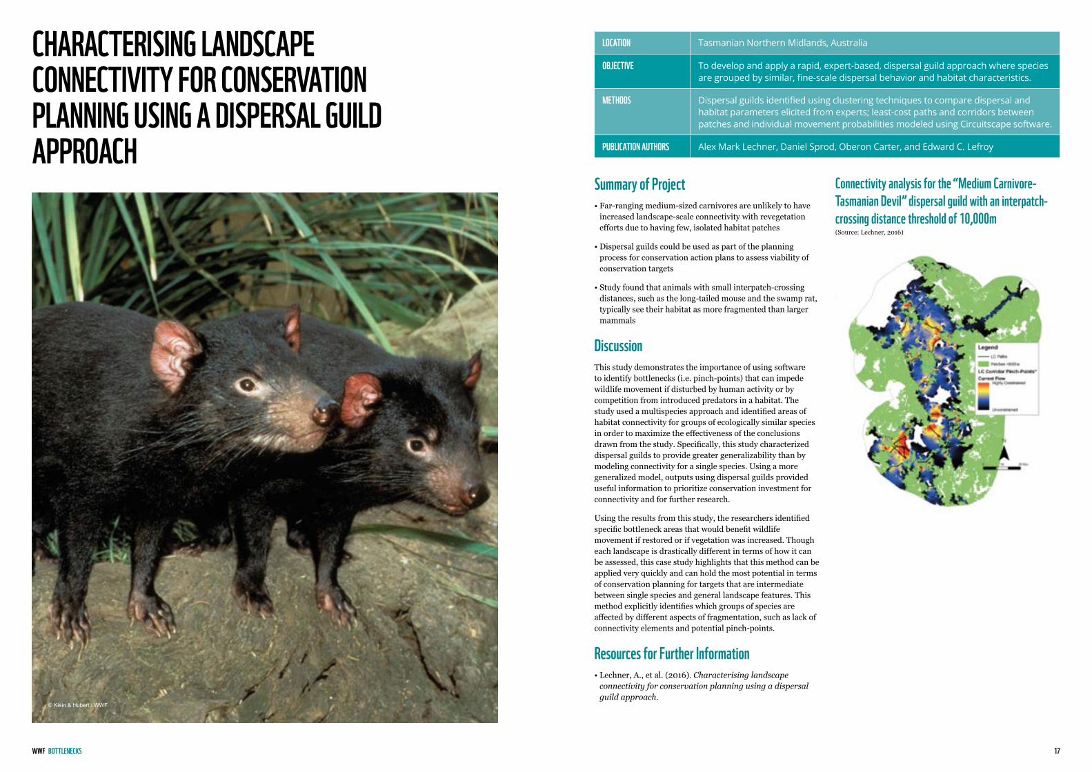
Connectivity analysis for the “Medium Carnivore-Tasmanian Devil” dispersal guild with an interpatch-crossing distance threshold of 10,000m (Source: Lechner, 2016)
LOCATION Tasmanian Northern Midlands, Australia
OBJECTIVE To develop and apply a rapid, expert-based, dispersal guild approach where species are grouped by similar, fine-scale dispersal behavior and habitat characteristics.
METHODS Dispersal guilds identified using clustering techniques to compare dispersal and habitat parameters elicited from experts; least-cost paths and corridors between patches and individual movement probabilities modeled using Circuitscape software.
PUBLICATION AUTHORS Alex Mark Lechner, Daniel Sprod, Oberon Carter, and Edward C. Lefroy
Summary of Project• Far-ranging medium-sized carnivores are unlikely to have
increased landscape-scale connectivity with revegetation efforts due to having few, isolated habitat patches
• Dispersal guilds could be used as part of the planning process for conservation action plans to assess viability of conservation targets
• Study found that animals with small interpatch-crossing distances, such as the long-tailed mouse and the swamp rat, typically see their habitat as more fragmented than larger mammals
DiscussionThis study demonstrates the importance of using software to identify bottlenecks (i.e. pinch-points) that can impede wildlife movement if disturbed by human activity or by competition from introduced predators in a habitat. The study used a multispecies approach and identified areas of habitat connectivity for groups of ecologically similar species in order to maximize the effectiveness of the conclusions drawn from the study. Specifically, this study characterized dispersal guilds to provide greater generalizability than by modeling connectivity for a single species. Using a more generalized model, outputs using dispersal guilds provided useful information to prioritize conservation investment for connectivity and for further research.
Using the results from this study, the researchers identified specific bottleneck areas that would benefit wildlife movement if restored or if vegetation was increased. Though each landscape is drastically different in terms of how it can be assessed, this case study highlights that this method can be applied very quickly and can hold the most potential in terms of conservation planning for targets that are intermediate between single species and general landscape features. This method explicitly identifies which groups of species are affected by different aspects of fragmentation, such as lack of connectivity elements and potential pinch-points.
Resources for Further Information• Lechner, A., et al. (2016). Characterising landscape
connectivity for conservation planning using a dispersal guild approach.
BOTTLENECKS
© Klein & Hubert / WWF
19WWF
NAME, TITLE WWF INTERNATIONAL
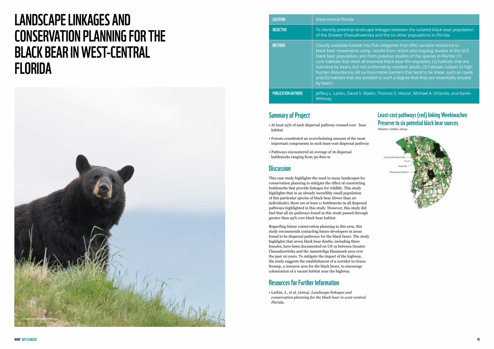
LANDSCAPE LINKAGES AND CONSERVATION PLANNING FOR THE BLACK BEAR IN WEST-CENTRAL FLORIDA
Least-cost pathways (red) linking Weekiwachee Preserve to six potential black bear sources(Source: Larkin, 2004)
LOCATION West-central Florida
OBJECTIVE To identify potential landscape linkages between the isolated black bear population of the Greater Chassahowitzka and the six other populations in Florida.
METHODS Classify available habitat into five categories that offer variable resistance to black bear movements using results from recent and ongoing studies of the GCE black bear population, and from previous studies of the species in Florida: (1) core habitats that meet all essential black bear life requisites, (2) habitats that are tolerated by bears, but not preferred by resident adults, (3) habitats subject to high human disturbance, (4) surmountable barriers that tend to be linear, such as roads, and (5) habitats that are avoided to such a degree that they are essentially unused by bears.
PUBLICATION AUTHORS Jeffery L. Larkin, David S. Maehr, Thomas S. Hoctor, Michael A. Orlando, and Karen Whitney
Summary of Project• At least 95% of each dispersal pathway crossed core bear
habitat
• Forests constituted an overwhelming amount of the most important components in each least-cost dispersal pathway
• Pathways encountered an average of 16 dispersal bottlenecks ranging from 30-800 m
DiscussionThis case study highlights the need in many landscapes for conservation planning to mitigate the effect of constricting bottlenecks that provide linkages for wildlife. This study highlights that in an already incredibly small population of this particular species of black bear (fewer than 20 individuals), there are at least 11 bottlenecks in all dispersal pathways highlighted in this study. However, this study did find that all six pathways found in this study passed through greater than 95% core black bear habitat.
Regarding future conservation planning in this area, this study recommends contacting future developers in areas found to be dispersal pathways for the black bears. The study highlights that seven black bear deaths, including three females, have been documented on US 19 between Greater Chassahowitzka and the Annutteliga Hammock area over the past 20 years. To mitigate the impact of the highway, the study suggests the establishment of a corridor to Green Swamp, a resource area for the black bears, to encourage colonization of a vacant habitat near the highway.
Resources for Further Information• Larkin, J., et al. (2004). Landscape linkages and
conservation planning for the black bear in west-central Florida.
BOTTLENECKS
© McDonald Mirabile / WWF-US

WWF 21
MONITORING
BOTTLENECKS
© Staffan Widstrand / WWF

23WWF
NAME, TITLE WWF INTERNATIONAL
EVALUATING THE EFFECTIVENESS OF LOCAL AND REGIONAL SCALE WILDLIFE CORRIDORS USING QUANTITATIVE METRICS OF FUNCTIONAL CONNECTIVITY
Central Kavango-Zambezi Transfrontier Conservation Area (Source: Naidoo, 2017)
LOCATION Kavango-Zambezi (KAZA transfrontier conservation landscape in southern Africa)
OBJECTIVE To evaluate a number of corridors developed at regional and at local scales that aim to improve connectivity for large wildlife in the central part of the Kavango-Zambezi transfrontier conservation area.
METHODS Radio collars to track wildlife movement; path selection functions; identification of environmental variables that promote/hinder path movement; Bayesian statistical modeling.
PUBLICATION AUTHORS R. Naidoo, J.W. Kilian, P. Du Preez, P. Beytell, O. Aschenborn, R.D. Taylor, and G. Stuart-Hill
Conclusions from Study• Selected paths of elephants are much more likely to be in
woodlands and floodplains in comparison to other types of habitat
• Boundary variables, including roads, rivers, fences, infrastructure, etc. all had strong statistical support as negative predictors of path selection
• Though the report demonstrated strong evidence for the movement of elephants, the study highlights that the data cannot be extrapolated to other species in the landscape
DiscussionThis study is an example of how movement corridors can be identified and analyzed for a particular species. By using radio collars to track movement of elephants, identifying environmental variables that help and hinder elephant movement through corridors, and statistical modeling to help predict elephant movement paths, the study identified indices that best predicted the way elephants move through corridors in the KAZA landscape.
The study found that the identified environmental variables were strong predictors for wildlife movement, particularly with the boundary variables (such as roads, fences, etc.) being a negative predictor of wildlife movement. Other factors, including the amount of vegetation in a corridor and land cover, were identified as generalized ways to predict wildlife movement. The study also highlighted how it is important not to generalize movement for all species in a landscape based on the movement of one species, and it suggests subsequent testing for other species to better understand corridor paths. The data collected in the study will be used to help communal conservancies in the area best facilitate wildlife movement on their lands.
Resources for Further Information• Naidoo, R., et. al. (2017). Evaluating the effectiveness
of local- and regional-scale wildlife corridors using quantitative metrics of functional connectivity.
MONITORING
© Gareth Bentley / WWF-US

25WWF
NAME, TITLE WWF INTERNATIONAL
HABITAT SUITABILITY AND MOVEMENT CORRIDORS OF GREY WOLF (CANIS LUPUS ) IN NORTHERN PAKISTAN
Study area in Northern Pakistan (Source: Kabir, 2017)
Potential movement corridors of wolf in Northern Pakistan (Source: Kabir, 2017)
LOCATION Northern Pakistan
OBJECTIVE To use non-invasive survey data from camera traps and genetic sampling to develop a habitat suitability model for C. lupus in northern Pakistan and to explore the extent of connectivity among populations.
METHODS Genetic sampling through scat samples; DNA analysis and species identification; camera traps; species distribution models; modeling potential movement corridors using Circuitscape 4.0; modeling wolf distribution using Maxent (ver. 3.4.0).
PUBLICATION AUTHORS M. Kabir, S. Hameed, H. Ali, L. Bosso, J. Ud Din, R. Bischof, S. Redpath, M. and Ali Nawaz
Conclusions from Study• Outside of protected areas, the highest frequency of
presence was found in Khanbari Valley in Gilgit-Baltistan
• Suitable wolf habitat was found within areas the study had selected as suspected wolf habitat range
• Four blocks of suitable habitat were identified in areas thought to be potential movement corridors
DiscussionThis case study represents the first large-scale study conducted on wolf distribution, habitat suitability, and movement corridors in Pakistan. The study showed high levels of predictive performance with the models used in the study and found that wolf habitat selection patterns were influenced by interactions between habitat attributes and human disturbances. The study also found that wolves avoided main roads and tracks and, in general, avoided any possibility of human disturbance, but followed livestock tracks and small, unpaved roads with low disturbance. Through modeling, the study also identified highly-suitable habitat and movement corridors outside of protected areas.
This case study demonstrates the usefulness of identifying movement corridors and suitable habitat for species. Of the four major blocks identified as high-quality habitat, one is protected, one is partially protected, and the rest have weak protection. The most suitable habitat identified in the study has poor connections with other populations. By identifying these areas, conservation organizations and the government of Pakistan can identify, with more precision, where wolves may disperse in the future if their population numbers increase, and identify priority areas for community engagement, management zones, and proactive planning. The habitat maps developed from this study will also help identify where to invest conservation resources and where new potential protected areas can be established.
Resources for Further Information• Kabir M., Hameed S., Ali H., Bosso L., Din J.U., Bischof R.
et al. (2017). Habitat suitability and movement corridors of grey wolf (Canis lupus) in Northern Pakistan. PLoS ONE 12(11): e0187027.
MONITORING
© McDonald Mirabile / WWF-US
WWF 27
IMPLEMENTATION
IMPLEMENTATION
© Staffan Widstrand / WWF
29WWF
NAME, TITLE WWF INTERNATIONAL
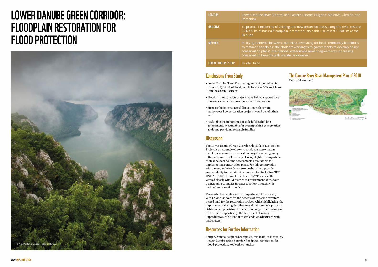
LOWER DANUBE GREEN CORRIDOR: FLOODPLAIN RESTORATION FOR FLOOD PROTECTION
The Danube River Basin Management Plan of 2010(Source: Schwarz, 2010)
LOCATION Lower Danube River (Central and Eastern Europe; Bulgaria, Moldova, Ukraine, and Romania).
OBJECTIVE To protect 1 million ha of existing and new protected areas along the river, restore 224,000 ha of natural floodplain, promote sustainable use of last 1,000 km of the Danube.
METHODS Policy agreements between countries; advocating for local community-led efforts to restore floodplains; stakeholders working with governments to develop policy/conservation plans; international water management agreements; discussing conservation benefits with private land-owners.
CONTACT FOR CASE STUDY Orieta Hulea
Conclusions from Study• Lower Danube Green Corridor agreement has helped to
restore 2,236 km2 of floodplain to form a 9,000 km2 Lower Danube Green Corridor
• Floodplain restoration projects have helped support local economies and create awareness for conservation
• Stresses the importance of discussing with private landowners how restoration projects would benefit their land
• Highlights the importance of stakeholders holding governments accountable for accomplishing conservation goals and providing research/funding
DiscussionThe Lower Danube Green Corridor Floodplain Restoration Project is an example of how to conduct a conservation plan for a large-scale conservation project spanning many different countries. The study also highlights the importance of stakeholders holding governments accountable for implementing conservation plans. For this conservation effort, many stakeholders were sought to help provide accountability for maintaining the corridor, including GEF, UNDP, UNEP, the World Bank, etc. WWF specifically worked closely with Ministries of Environment of the four participating countries in order to follow through with outlined conservation goals.
The study also emphasizes the importance of discussing with private landowners the benefits of restoring privately-owned land for the restoration project, while highlighting the importance of stating that they would not lose their property rights and emphasizing the benefits of long-term restoration of their land.. Specifically, the benefits of changing unproductive arable land into wetlands was discussed with landowners.
Resources for Further Information• http://climate-adapt.eea.europa.eu/metadata/case-studies/
lower-danube-green-corridor-floodplain-restoration-for-flood-protection/#objectives_anchor
IMPLEMENTATION
© Wild Wonders of Europe / Ruben Smit / WWF

31WWF
NAME, TITLE WWF INTERNATIONAL
GROWTH CENTRES BIODIVERSITY OFFSET PROGRAM
Areas of Program Operation (Source: State of NSW, 2017)
Land Protected by Program (Source: State of NSW, 2017)
LOCATION Western Sydney, Australia
OBJECTIVE To permanently protect much of the remaining bushland in western Sydney and the surrounding regions. This program is part of an offset for the net loss of 398 hectares of vegetation in the developable areas of Sydney’s growth centers since 2007.
METHODS Acquire land from willing landowners for new reserves; purchase biodiversity credits from existing conservation agreements on private land; fund the establishment of perpetual conservation agreements on private land.
PUBLICATION AUTHORS State New South Wales and Office of Environment and Heritage
Results of Initiative• 567 hectares of high conservation value land has been
protected in 13 locations in western Sydney
• 545 hectares of the total protected area consist of land listed as part of a threatened ecological community under state legislation
• Valuable habitat for 24 threatened flora and fauna species has been protected using the program’s funds
DiscussionThe Growth Centres Biodiversity Offset program is an example of how biodiversity offsets can mitigate the impact of economic and industrial development. With the Growth Centres Biodiversity Offset Program, lands are protected primarily by voluntarily acquiring land for preservation or establishing conservation agreements with willing landowners. The funds are administered by an independent trust called the New South Wales Environmental Trust to the New South Wales Office of Environment and Heritage. Both governmental and non-governmental bodies run the trust.
This program demonstrates the usefulness of protecting large areas of land before they are developed. Instead of simply mitigating the impact of urban development and conserving small patches of land in cities, this program has demonstrated how urban development can be compensated by restoring and growing biodiversity in a habitat owned by companies or private landowners. Currently, this program is designating all of the funding in one area of Australia, the Cumberland Plain, and to date, money from this program has only been used for this area.
Resources for Further Information• State of NSW and Office of Government and Heritage
(2017). Growth Centres Biodiversity Offset Program annual report 2016-17.
• http://www.environment.nsw.gov.au/biocertification/GrowthCentres.htm
IMPLEMENTATION
© Tea Smart / WWF
33WWF
NAME, TITLE WWF INTERNATIONAL
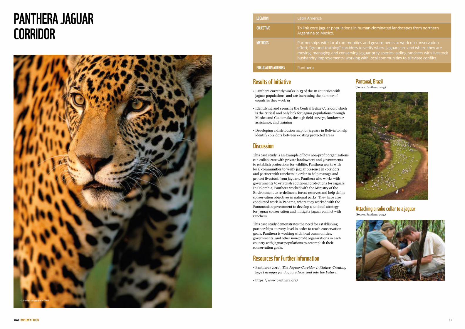
PANTHERA JAGUAR CORRIDOR
Pantanal, Brazil (Source: Panthera, 2015)
Attaching a radio collar to a jaguar(Source: Panthera, 2015)
LOCATION Latin America
OBJECTIVE To link core jaguar populations in human-dominated landscapes from northern Argentina to Mexico.
METHODS Partnerships with local communities and governments to work on conservation effort; “ground-truthing” corridors to verify where jaguars are and where they are moving; managing and conserving jaguar prey species; aiding ranchers with livestock husbandry improvements; working with local communities to alleviate conflict.
PUBLICATION AUTHORS Panthera
Results of Initiative• Panthera currently works in 13 of the 18 countries with
jaguar populations, and are increasing the number of countries they work in
• Identifying and securing the Central Belize Corridor, which is the critical and only link for jaguar populations through Mexico and Guatemala, through field surveys, landowner assistance, and training
• Developing a distribution map for jaguars in Bolivia to help identify corridors between existing protected areas
DiscussionThis case study is an example of how non-profit organizations can collaborate with private landowners and governments to establish protections for wildlife. Panthera works with local communities to verify jaguar presence in corridors and partner with ranchers in order to help manage and protect livestock from jaguars. Panthera also works with governments to establish additional protections for jaguars. In Colombia, Panthera worked with the Ministry of the Environment to re-delineate forest reserves and help define conservation objectives in national parks. They have also conducted work in Panama, where they worked with the Panamanian government to develop a national strategy for jaguar conservation and mitigate jaguar conflict with ranchers.
This case study demonstrates the need for establishing partnerships at every level in order to reach conservation goals. Panthera is working with local communities, governments, and other non-profit organizations in each country with jaguar populations to accomplish their conservation goals.
Resources for Further Information• Panthera (2015). The Jaguar Corridor Initiative, Creating
Safe Passages for Jaguars Now and into the Future.
• https://www.panthera.org/
IMPLEMENTATION
© Staffan Widstrand / WWF

35WWF
NAME, TITLE WWF INTERNATIONAL
PLANTATIONS MEET A WORLD HERITAGE SITE
Benefits of SiyaQhubeka Forest’s PlantAttaching a radio collar to a jaguar (Source: Panthera, 2015)
LOCATION iSimangaliso National Park, South Africa
OBJECTIVE To protect one of South Africa’s most important wetland areas near iSimangaliso National Park by creating partnerships between forestry operations and environmentalists to protect this vital ecosystem.
METHODS Formally designate previously-unprotected land as part of a national park to protect wildlife and land; partner with governments and private industries to restore land.
PUBLICATION AUTHORS New Generation Plantations Project
Results of Initiative• Area near Lake St. Lucia was restored and formally
incorporated into the protected space of iSimangaliso National Park
• A Total of 9,000 new hectares of land were incorporated into the park for formal protected designation
• Restoration of the land has encouraged tourism in areas near Lake St. Lucia that were previously designated for industrial use
DiscussionMuch of the land area in iSimangaliso Wetland Park was disputed due to pressures from conservationists seeking to protect land and private industry seeking to utilize the land for industrial use. This conflict was concentrated near Lake St. Lucia where many commercial pine plantations were located. The lake was experiencing reduced freshwater flow and subsequent impacts to wildlife due to these poorly-placed commercial plantations. Due to these issues, the private organizations that managed the areas of forest under dispute (Mondi and SiyaQhubeka Forests) worked with the government, environmental NGOs, and the park authority to determine which areas of land were suitable for commercial plantations and which were most suitable for designation as protected areas. The trees for industrial use were then removed and the land was restored back to wetlands in cooperation with the iSimangaliso Wetland Park Authority. The restored land was then formally incorporated into the park for protected designation. This policy success ultimately designated protection for 9,000 hectares of land previously utilized for industry.
Resources for Further Information• New Generation Plantations Project. (2011). Plantations
meet a World Heritage Site.
• http://newgenerationplantations.org/en
IMPLEMENTATION
RESTORING WETLANDBY PIMPROVING SOIL AND WATER CONDIDTIONS AND ENCOURAGING BIODIVERSITY
INCREASING HABITATSFOR A WIDE RANGE OF SPECIES
IMPROVING LIVELIHOODBY PROMOTING SMALL BUSINESS INITIATIVES
© Carrie Carter

37WWF
NAME, TITLE WWF INTERNATIONAL
FOREST RESTORATION, CARBON STORAGE AND INCOME GENERATION: MONTE PASCOAL – PAU BRASIL ECOLOGICAL CORRIDOR
How the Performance of Restoration Projects is Measured (New Generation, 2011)
LOCATION Monte Pascoal-Pau Brasil Ecological Corridor, Brazil
OBJECTIVE To restore Atlantic rainforest on suitable areas belonging to local land owners, especially cattle ranchers. The project ultimately seeks to connect isolated fragments of the Atlantic Rainforest and form a native forest corridor between two national parks, Monte Pascoal and Pau Brasil.
METHODS Coordinate a rainforest restoration program financed by the selling of carbon credits; utilize local community-led efforts.
PUBLICATION AUTHORS New Generation Plantations Project
Results of Initiative• Forty-five stable jobs for people in the communities have
been created in the communities where the restoration efforts are taking place
• The sold carbon credits that are funding the restoration project have led to the restoration and replanting of 318 hectares of rainforest
• The project has given rise to four commercial carbon credit contracts
DiscussionThis case study is an example of how local, community-led efforts can be developed out of efforts by private industries interested in sustaining forest and wildlife corridors. In Brazil, the agro-industrial enterprise company Veracel is coordinating a rainforest restoration program financed by the selling of carbon credits. The project seeks to restore suitable areas of the Monte Pascoal–Pau Brasil Ecological Corridor, particularly areas belonging to local land-owners. In addition to its overall goal of restoring forest area, the project has also created economic opportunities for local communities through its use of community-led efforts. Cooplantar, a local cooperative that carries out much of the planting and restoration work, has provided forty-five stable jobs for people in the communities where the restoration is taking place. This is also an example of how sold carbon credits can be used to effectively restore corridors and forests.
Resources for Further Information• New Generation Plantations Project (2011). Forest
restoration, carbon storage and income generation: Monte Pascoal – Pau Brasil Ecological Corridor.
• http://newgenerationplantations.org/en
IMPLEMENTATION
RESTORED AREAHECTORS
CARBON STORAGETONS
BIODIVERSITY FUNCTIONSINDEXES
SOCIAL BENIFITSJOBS AND INCOMES
© Jaime Rojo / WWF-US

39WWF
NAME, TITLE WWF INTERNATIONAL
THE SUSTAINABLE FOREST MOSAICS INITIATIVE
Sustainable forest mosaics: a response to the challenge of producing wood fibre while protecting ecosystems and livelihoods (New Generation, 2011)
LOCATION Atlantic Forest, Brazil
OBJECTIVE To establish an innovative and collaborative model of production, conservation, and livelihood generation by bringing together global and national companies, non-profit organizations, and local institutions. This case study highlights how the Sustainable Forest Mosaics Initiative has sought to protect Brazil’s Atlantic Forest, and the initiative hopes its model will be applied in other regions of the world with similar plantation forests that can bring benefits within a landscape.
METHODS Coordinate interests of multiple stakeholders across a wide variety of industries; promote local community-led efforts through restoration projects.
PUBLICATION AUTHORS New Generation Plantations Project
Results of Initiative• A group was formed to specifically support the restoration
of the Atlantic rainforest biome as a result of the Sustainable Forest Mosaics Initiative
• The initiative has developed a methodology for integrated planning and monitoring of biodiversity, including protected areas and forest restoration.
• A monitoring protocol for key ecological groups (birds, mammals, and flora) has been developed out of the initiative
DiscussionThis case study is an example of effective implementation of landscape-level planning based on the interest of various stakeholders worldwide. Established in 2007 in Brazil, The Sustainable Forest Mosaics Initiative is seeking to promote the long-term preservation of Brazil’s Atlantic Forest by coordinating the interests of multiple stakeholders in sustaining the forest area. This will, in turn, sustain the many wildlife corridors in Brazil’s Atlantic Forest. The founding partners were Brazilian pulp and paper companies Fibria, Veracel and Suzano; paper-based consumer products giant KimberlyClark; and NGOs Conservation International, The Nature Conservancy, and Instituto BioAtlântica. By having a wide variety of stakeholders with interests ranging from conservation to industrial use of the forest, a comprehensive landscape level plan can be developed that maintains the forest for a wide variety of uses. The initiative has been effective thus far. By 2009, partner companies had brought more than 8,000 hectares of rainforest under protection. By 2011, they had restored 2,700 hectares on their land.
Resources for Further Information• New Generation Plantations Project. (2011). The
Sustainable Forest Mosaics Initiative.
• http://newgenerationplantations.org/en
IMPLEMENTATION
© Jaime Rojo / WWF-US

41WWF
NAME, TITLE WWF INTERNATIONAL
CONSERVATION EASEMENTS AS AN APPROACH
Protected and Conservation Lands In Yellowstone to Yukon region in 1993 (Source: Yellowstone, 2018)
Protected and Conservation Lands In Yellowstone to Yukon region in 2013 (Source: Yellowstone, 2018)
LOCATION United States
OBJECTIVE To provide incentive to private landowners to protect at-risk land and corridors, which is a common legal tool utilized by land trusts and conservation organizations in the United States.
METHODS Exchange portion of rights from private landowners to land trust or conservation organization interested in long-term protection of land; tax incentives for private landowners.
Summary of Conservation Easements as an approach• Allows private landowners to know that their land will be
protected regardless of the future owner
• Landowners qualify for a tax deduction of 50% of their annual income if they designate their land as a conservation easement
• Farmers and ranchers qualify for a tax deduction of 100% of their annual income for up to 15 years with conservation easements
DiscussionConservation easements are an important legal tool used in the United States to provide incentive to private landowners and farmers to protect their land for conservation purposes. Conservation easements primarily work through private landowners giving up a portion of the rights to their land to a land trust or conservation organization interested in protecting the land regardless of who owns it. Restrictions on land due to conservation easements include activities such as recreation, logging, restrictions on agriculture, etc.
Conservation easements are an extremely effective legal tool used to protect land and are very commonly used. One example that demonstrates their effectiveness is that of the Yellowstone to Yukon Conservation Initiative. Through conservation easements and by working with landowners, the organization has purchased 200,000 hectares of private lands (Yellowstone, 2014). Another well-known organization that has been very successful in protecting land with conservation easements is The Nature Conservancy. Through conservation easements, they currently manage 1.3 million hectares of land (The Nature Conservancy, 2018).
Resources for Further Information• Yellowstone to Yukon Conservation Initiative (2014). Y2Y
Achievements. Retrieved from https://y2y.net/vision/our-progress/y2y-achievements
• Land Trust Alliance. (2015). Using the Conservation Tax Incentive.
• Yellowstone to Yukon Conservation Initiative. “What Progress Looks Like – Protected Land.” Y2Y. 2018. https://y2y.net/vision/our-progress.
IMPLEMENTATION
© Jeffrey West
43WWF
NAME, TITLE WWF INTERNATIONAL
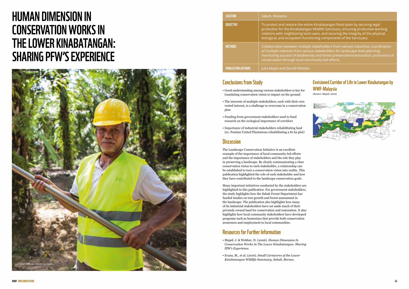
HUMAN DIMENSION IN CONSERVATION WORKS IN THE LOWER KINABATANGAN: SHARING PFW’S EXPERIENCE
Envisioned Corridor of Life in Lower Kinabatangan by WWF-Malaysia (Source: Majail, 2006)
LOCATION Sabah, Malaysia
OBJECTIVE To protect and restore the entire Kinabatangan flood plain by securing legal protection for the Kinabatangan Wildlife Sanctuary, ensuring productive working relations with neighboring land users, and securing the integrity of the physical, biological, and ecosystem functioning components of the Sanctuary.
METHODS Collaboration between multiple stakeholders from various industries; coordination of multiple interests from various stakeholders for landscape level planning; monitoring success of biodiversity and forest preservation/restoration; promotion of conservation through local community-led efforts.
PUBLICATION AUTHORS Julia Majail and Darrell Webber
Conclusions from Study• Good understanding among various stakeholders is key for
translating conservation vision to impact on the ground
• The interests of multiple stakeholders, each with their own vested interest, is a challenge to overcome in a conservation plan
• Funding from government stakeholders used to fund research on the ecological importance of corridors
• Importance of industrial stakeholders rehabilitating land (ex. Pontian United Plantations rehabilitating a 81 ha plot)
DiscussionThe Landscape Conservation Initiative is an excellent example of the importance of local community-led efforts and the importance of stakeholders and the role they play in preserving a landscape. By clearly communicating a clear conservation vision to each stakeholder, a relationship can be established to turn a conservation vision into reality. This publication highlighted the role of each stakeholder and how they have contributed to the landscape conservation goals.
Many important initiatives conducted by the stakeholders are highlighted in this publication. For government stakeholders, the study highlights how the Sabah Forest Department has funded studies on tree growth and forest assessment in the landscape. The publication also highlights how many of its industrial stakeholders have set aside much of their privately-owned land for conservation and restoration. It also highlights how local community stakeholders have developed programs such as homestays that provide both conservation awareness and employment to local communities.
Resources for Further Information• Majail, J. & Webber, D. (2006). Human Dimension In
Conservation Works In The Lower Kinabatangan: Sharing PfW’s Experience.
• Evans, M., et al. (2016). Small Carnivores of the Lower Kinabatangan Wildlife Sanctuary, Sabah, Borneo.
IMPLEMENTATION
© WWF-Malaysia / Mazidi Abd Ghani
45WWF
NAME, TITLE WWF INTERNATIONAL
BUSINESS BIODIVERSITY OFFSETS
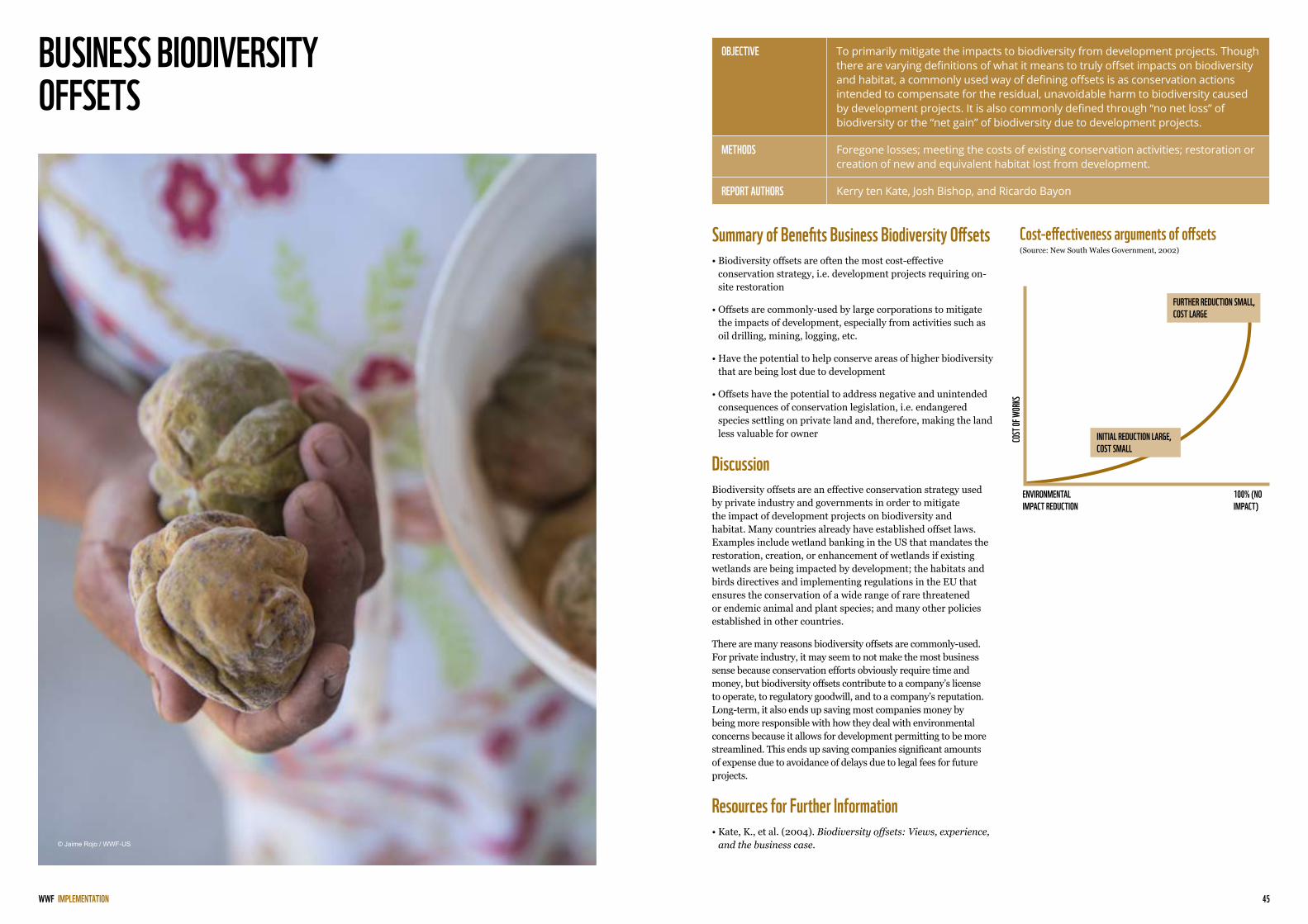
Cost-effectiveness arguments of offsets (Source: New South Wales Government, 2002)
OBJECTIVE To primarily mitigate the impacts to biodiversity from development projects. Though there are varying definitions of what it means to truly offset impacts on biodiversity and habitat, a commonly used way of defining offsets is as conservation actions intended to compensate for the residual, unavoidable harm to biodiversity caused by development projects. It is also commonly defined through “no net loss” of biodiversity or the “net gain” of biodiversity due to development projects.
METHODS Foregone losses; meeting the costs of existing conservation activities; restoration or creation of new and equivalent habitat lost from development.
REPORT AUTHORS Kerry ten Kate, Josh Bishop, and Ricardo Bayon
Summary of Benefits Business Biodiversity Offsets• Biodiversity offsets are often the most cost-effective
conservation strategy, i.e. development projects requiring on-site restoration
• Offsets are commonly-used by large corporations to mitigate the impacts of development, especially from activities such as oil drilling, mining, logging, etc.
• Have the potential to help conserve areas of higher biodiversity that are being lost due to development
• Offsets have the potential to address negative and unintended consequences of conservation legislation, i.e. endangered species settling on private land and, therefore, making the land less valuable for owner
DiscussionBiodiversity offsets are an effective conservation strategy used by private industry and governments in order to mitigate the impact of development projects on biodiversity and habitat. Many countries already have established offset laws. Examples include wetland banking in the US that mandates the restoration, creation, or enhancement of wetlands if existing wetlands are being impacted by development; the habitats and birds directives and implementing regulations in the EU that ensures the conservation of a wide range of rare threatened or endemic animal and plant species; and many other policies established in other countries.
There are many reasons biodiversity offsets are commonly-used. For private industry, it may seem to not make the most business sense because conservation efforts obviously require time and money, but biodiversity offsets contribute to a company’s license to operate, to regulatory goodwill, and to a company’s reputation. Long-term, it also ends up saving most companies money by being more responsible with how they deal with environmental concerns because it allows for development permitting to be more streamlined. This ends up saving companies significant amounts of expense due to avoidance of delays due to legal fees for future projects.
Resources for Further Information• Kate, K., et al. (2004). Biodiversity offsets: Views, experience,
and the business case.
IMPLEMENTATION
FURTHER REDUCTION SMALL, COST LARGE
INITIAL REDUCTION LARGE, COST SMALL
COST
OF W
ORKS
ENVIRONMENTAL IMPACT REDUCTION
100% (NO IMPACT)
© Jaime Rojo / WWF-US

47WWF
NAME, TITLE WWF INTERNATIONAL
YELLOWSTONE TO YUKON CONSERVATION INITIATIVE
Priority Areas Being Protected by Yellowstone to Yukon Conservation Initiative (Source: Yellowstone, 2017)
LOCATION Yellowstone National Park to Yukon Territory
OBJECTIVE To establish and protect a long-term network of protected areas from Yellowstone National Park to Yukon.
METHODS Conservation easements; private land acquisition; wildlife crossing infrastructure; established policy protecting wildlife on various governmental levels; radio collars to track wildlife movement.
PRESIDENT OF ORGANIZATION
Karsten Heuer
Results of Initiative• Helped establish two new national park reserves (Nahanni
and Nááts’ihch’oh)
• Protected 161,874 ha of land in the Flathead River Valley from oil and gas development
• Purchased over 222,577 ha of land in the corridor through conservation easements and private land acquisition
• Inspired development of wildlife crossing infrastructure in Banff National Park to reduce wildlife vehicle collisions
DiscussionThe Yellowstone to Yukon Conservation Initiative is an ambitious conservation project that has successfully secured long-term protection for a large corridor stretching from the northwestern United States to the Yukon territory in Canada. This initiative is an example of how conservation easements and private land acquisition can be used to protect large corridors.
Funding for the programs and for the land purchased by this initiative has come from a variety of sources with most coming primarily from individual donations, conservation organizations, and grants from the U.S. and Canadian governments. As this initiative has grown, more interested stakeholders and private landowners have contacted the organization to expand the land area that is protected and to protect key corridor linkages. The initiative also funds much of the research to identify key corridor linkages with staff researchers or by partnering with other organizations.
Resources for Further Information• https://y2y.net/ (Primary Website for Yellowstone to Yukon
Initiative)
• https://y2y.net/publications/reports (All technical reports produced by the Yellowstone to Yukon Initiative Initiative)
• Yellowstone to Yukon Conservation Initiative (2014). Y2Y Vision: 20 Years of Progress.
IMPLEMENTATION
© Fritz Pölking / WWF

49WWF
NAME, TITLE WWF INTERNATIONAL
BIBLIOGRAPHY
• Anderson, M. (1999). Conservation Corridor Planning at the Landscape Level.
• Butcher, D. (1969). Brief History of the National Parks. Retrieved from https://www.loc.gov/collections/national-parks-maps/articles-and-essays/brief-history-of-the-national-parks/
• Cheryl-Lesley B. Chetkiewicz & Mark S. Boyce. (2009). Use of resource selection functions to identify conservation corridors.
• Circuitscape. (2018). Linkage Mapper. Retrieved from http://www.circuitscape.org/linkagemapper
• Conefor. (2018). What is Conefor?. Retrieved from http://www.conefor.org/
• Dadhwal, V., et al. (2013). Monitoring Forests for Sustainability: Remote Sensing Studies in India. Retrieved from https://www.researchgate.net/profile/Subrata_Nandy/publication/255027450_Monitoring_Forests_for_Sustainability_Remote_Sensing_studies_in_India/links/53e303510cf275a5fdda73dd/Monitoring-Forests-for-Sustainability-Remote-Sensing-studies-in-India.pdf
• Debonnet, G. & Nindi S. (2017). Technical Study on Land Use and Tenure Options and Status of Wildlife Corridors in Tanzania. April 2017.
• Evans, M., et al. (2016). Small Carnivores of the Lower Kinabatangan Wildlife Sanctuary, Sabah, Borneo.
• FAO (2016). Global Forest Resources Assessment 2015, How are the world’s forests changing? Second edition.
• Haber, J., et. al. (2015). Planning for Connectivity. Retrieved from https://www.nationalforests.org/assets/pdfs/0.60-Flick-DOW-Planning-For-Connectivity.pdf
• Jones, T. et al. (2012). Vanishing Wildlife Corridors and Options for Restoration: A Case Study from Tanzania.
• Juffe-Bignoli, D. (2014). Protected Planet Report 2014. UNEP-WCMC: Cambridge, UK. Retrieved from http://wdpa.s3.amazonaws.com/WPC2014/protected_planet_report.pdf
• Kabir M., Hameed S., Ali H., Bosso L., Din J.U., Bischof R. et al. (2017). Habitat suitability and movement corridors of grey wolf (Canis lupus) in Northern Pakistan. PLoS ONE 12(11): e0187027. https://doi.org/10.1371/journal.pone.0187027
• Land Trust Alliance. (2015). Using the Conservation Tax Incentive.
• Larkin, J., et al. (2004). Landscape linkages and conservation planning for the black bear in west-central Florida.
• Lechner, A., et al. (2016). Characterising landscape connectivity for conservation planning using a dispersal guild approach.
• Majail, J. & Webber, D. (2006). Human Dimension In Conservation Works In The Lower Kinabatangan: Sharing PfW’s Experience.
• “Map of New Zealand”. Rangitoto Island Historic Conservation Trust. 2009. http://w.rangitoto.org/pages/where.html
• Martha J. Groom. (2005). Threats to Biodiversity.
• Naidoo, R., et. al. (2017). Evaluating the effectiveness of local- and regional-scale wildlife corridors using quantitative metrics of functional connectivity.
• New Generation Plantations Project. (2011). Forest restoration, carbon storage and income generation: Monte Pascoal – Pau Brasil Ecological Corridor.
• New Generation Plantations Project. (2011). The Sustainable Forest Mosaics Initiative.
• New Generation Plantations Project. (2011). Plantations meet a World Heritage Site.
• New South Wales Office of Environment & Heritage (2004). Wildlife Corridors. Retrieved from http://www.environment.nsw.gov.au/resources/nature/landholderNotes15WildlifeCorridors.pdf
• New South Wales Government. 2002. Green offsets for sustainable development. Concept paper. Environment Protection Authority, Sydney. April 2002.
• Palumbo, I., et. al. (2016). Remote Sensing in Ecology and Conservation. Retrieved from http://onlinelibrary.wiley.com/doi/10.1002/rse2.31/epdf
• Saura, S. & Pardo, J. (2017). Halting the isolation of jaguars: Where to act locally to sustain connectivity in their southernmost population. Animal Conservation, May 2017.
• Schwarz, U. (2010). Assessment of the Restoration Potential Along the Danube and Main Tributaries. Retrieved from http://d2ouvy59p0dg6k.cloudfront.net/downloads/wwf_factsheet_danube_restoration_potential_oct2010.pdf
• Singh, B. R. (1994). LAND USE CHANGE, DIVERSIFICATION OF AGRICULTURE AND AGROFORESTRY IN NORTHWEST INDIA. Retrieved from http://citeseerx.ist.psu.edu/viewdoc/download?doi=10.1.1.491.6910&rep=rep1&type=pdf
• Spatial Ecology and Conservation Lab. (2018). LSCorridorsDescription. Retrieved from https://github.com/LEEClab/LS_CORRIDORS/wiki/LSCorridorsDescription
• State of NSW and Office of Government and Heritage (2017). Growth Centres Biodiversity Offset Program annual report 2016-17.
• Kate, K., et al. (2004). Biodiversity offsets: Views, experience, and the business case.
• The Nature Conservancy (2018). Conservation Easements. Retrieved from https://www.nature.org/about-us/private-lands-conservation/conservation-easements/fast-facts-about-conservation-easements.xml
• Wilson, M., et al. (2015). Habitat fragmentation and biodiversity conservation: key findings and future challenges.
• Yellowstone to Yukon Conservation Initiative (2014). Y2Y Achievements. Retrieved from https://y2y.net/vision/our-progress/y2y-achievements
• Yellowstone to Yukon Conservation Initiative (2017). Introducing Y2Y 2017. Retrieved from https://y2y.net/publications/introducing-y2y-2017.pdf/view
• Yellowstone to Yukon Conservation Initiative. “What Progress Looks Like – Protected Land.” Y2Y. 2018. https://y2y.net/vision/our-progress.
© Thuto Moutloatse

Back cover © Adriano Gambarini / WWF Living Amazon Initiative / WWF-Brazil
© 2019 Paper 100% recycled
© 1986 Panda symbol WWF – World Wide Fund for Nature (Formerly World Wildlife Fund) ® “WWF” is a WWF Registered Trademark. WWF, Avenue du Mont-Bland, 1196 Gland, Switzerland. Tel. +41 22 364 9111. Fax. +41 22 364 0332.
For contact details and further information, please visit our international website at www.panda.org
OUR MISSION IS TO CONSERVE NATURE AND REDUCE THE MOST PRESSING THREATS TO THE DIVERSITY OF LIFE
ON EARTH.