Embed Size (px)
Citation preview

CANADA’S NEWEST HIGH-GRADE DISCOVERY Corporate PresentationQ1 2020

DISCLAIMERCertain statements in this presentation constitute forward looking information within the meaning of applicable securities laws. These statements relate to future events or New Found Gold Corp. (“New Found Gold Corp.” or “the Company”) future performance, business prospects or opportunities. Any statements that express or involve discussions with respect to predictions, expectations, beliefs, plans, projections, objectives, assumptions or future events or performance (often, but no always, using words or phrases such as “seek”, “anticipate”, “plan”, “continue”, “estimate”, “expect”, “forecast”, “may”, “will”, “project”, “predict”, “potential”, “targeting”, “intend”, “could”, “might”, “should”, “believe”, “outlook” and similar expressions) are not statements of historical fact and may be forward looking information.
Forward looking information in this presentation includes, but is not limited to, statements with respect to the Company’s future plans to acquire additional targets or properties including equity positions with partners, enter into joint venture, earn-in, royalty or streaming structure agreements, or dispose of properties, achieve an income stream which would permit it to pay a dividend on its outstanding shares, the timing and amount of future exploration and expenditures and the possible results of such exploration.
Forward looking information involves known and unknown risks, uncertainties and other factors which may cause the actual results, performance or achievements of the Company to be materially different from any future results, performance or achievements expressed or implied by the forward looking information. Such risks include, among others, the risk that the Company will not be successful in completing additional acquisitions, risks relating to the results of exploration activities and risks relating to the ability of the Company to enter into joint venture, earn-in, royalty or streaming structure agreements, or dispose of properties, future prices of mineral resources; accidents, labor disputes and other risks of the mining industry including continued community and government support of the Company’s projects. The Company believes that the expectations reflected in such forward looking information are reasonable, but no assurance can be given that these expectations will prove to be correct and such forward-looking information should not be unduly relied upon. These statements speak only as of the date of this presentation. The Company does not intend, and does not assume any obligation, to update any forward-looking information except as required by law.
Resource estimates presented for the Knob deposit are historic resources and New Found Gold Corp’s qualified person has not done sufficient work to classify the historical resource estimate as current mineral resources nor is the Company treating the historical estimate as current mineral resources. Additional confirmatory drilling would be required to classify the historical estimate as a current mineral resource. The reader is cautioned not to rely on the estimate as the historic resource does not conform to the current CIM standards for mineral resource classification and makes assumptions about continuity of mineralization through long section methodologies typical of the time of the report’s publication has not completed sufficient work to confirm the results of the historical resource estimate. Therefore the estimates cannot, and should not be relied upon. New Found Gold Corp. is not treating this as a current mineral resource.
True widths of diamond drilling mineral intercepts are unknown or otherwise stated. In most cases Insufficient drilling has been conducted to determine a true width of mineralizationGreg Matheson, P.Geo, Chief Operating Officer of New Found Gold Corp. has reviewed the technical information included in this presentation as the Qualified Person.
-2-

-3-
S E C T I O N 1
INTRODUCTION AND OVERVIEW

• The first hole of the Company’s maiden drill program at its Queensway Project in Newfoundland intersected 92.9 g/t Au over 19.0 meters including 285.2 g/t Au over 6.0 meters, starting 96 m down hole
• Strong similarities recently recognized to Kirkland Lake’s Fosterville mine
• District scale project with over 85 km of prospective strike• Project area largely off limits for exploration prior to 1980’s resulting in
limited historic work• Excellent access and infrastructure. Property is located 12 km west of
Gander, Newfoundland, is bisected by the Trans Canada Highway, and is accessible via a network of logging roads.
• Large drill campaign planned on multiple high grade targets over 7 kilometers of strike with mobilization beginning May 2020
OVERVIEW
-4-

DISTRICT SCALE, MULTIPLE HIGH GRADE TARGETS• The Queensway project covers more than 85 km NE to SW of strike on two primary fault zones (Appleton and JBP)• While the recent 92.9 g/t Au over 19.0 meters interval is impressive, previous work has defined multiple showings and
high grade drill intervals over 5 km+ of strike length on the northern part of the property (illustrative area to the right)
-5-

CAPITAL STRUCTURE - POST COMBINATION
Share Count
93,924,249
Warrants
16,000,000
Options
~7,535,000
Fully Diluted
117,459,249
Cash plus Marketable Securities
~$24,200,000
Debt Outstanding
$0
-6-
EricSprott
Insiders and Others
RobMcEwen
48% 15% 14% 7% 16%

MANAGEMENT AND BOARD
Collin KettellFounder & Executive
Chairman
Founder and manager of Palisade Global Investments
Ltd., a $50M family office and merchant bank, primarily
investing in the junior resource sector; comes from
a family with deep ties to mining, including co-founding AuEx Ventures, the company responsible for discovering the Long Canyon deposit, a
project ultimately acquired by Newmont Mining for $2.3B
More than 10 years of experience in mining and capital markets; Worked with Timmins, Kirkland
Lake, and Red Lake; Managed all aspects of a
mining operation in Ghana; Previously a mining analyst
with Pinetree Capital; Founder and CEO of
Goldspot Discoveries Inc.
Over 25 years of capital market experience
specializing in the resource sector;
A founder and financier of many start-up companies
with experience on the TSX, NYSE, NASDAQ, London AIM and Swiss Stock Exchange;
Founder of Deep 6 PLC, American Eagle Oil and
Gas,Inc as well a founding general partner in Aquastone
Capital LLC; Executive Chairman of Triumph
Gold Corp. and Chairman of EXM Farming Corp.
John AndersonDirector
Denis LavioletteFounder and President
-7-
Mining engineer with over 30 years of operations,
consulting and investment banking experience. Includes work on feasibility studies for
numerous mining projects worldwide, investment
banking/due diligence roles in over 200 institutional
equity financings. Significant experience advising
management and boards on merger and acquisition
transactions.
Craig Roberts, P.Eng.CEO & Director

KEY PEOPLE
-8-
Ken RatteeV.P. Exploration
Michael Kanevsky, CPACFO
Greg Matheson, P.Geo.COO
Dr. Quinton Hennigh, Ph.D.Advisor
A professional geologist with over 12 years managing
grass roots exploration through to advanced
exploration projects; former exploration manager of
Northern Gold Mining, senior project manager for Oban Mining and Osisko Mining.
Responsible for the discovery and delineation of the >2.0M
oz. Garrison Gold project in NE Ontario managing
exploration from early stage through trial production
mining.
Brings over 36 years’ experience in base and precious metal mineral exploration in various
management roles; former chief geologist for Kirkland Lake Gold’s Macassa Mine with extensive experience
developing, supervising and implementing exploration
campaigns for several corporations, including Lac
Minerals, Kirkland Lake Gold, Kinross Gold and Barrick
Gold.
A Chartered Professional Accountant with nine
years of post- designation professional experience working with public and
private companies. Expertise in corporate reporting,
financial processes and risk management. Began his professional career in the
audit and assurance practice at Deloitte.
Economic geologist with 25 years of exploration experience, mainly gold
related. Early in his career, he explored for major mining firms including Homestake Mining Company, Newcrest Mining Ltd and Newmont Mining Corporation. Led
exploration for Gold Canyon Resources at the Springpole
alkaline gold project near Red Lake Ontario, a 5 million ounce gold asset that was
recently sold.
-9-
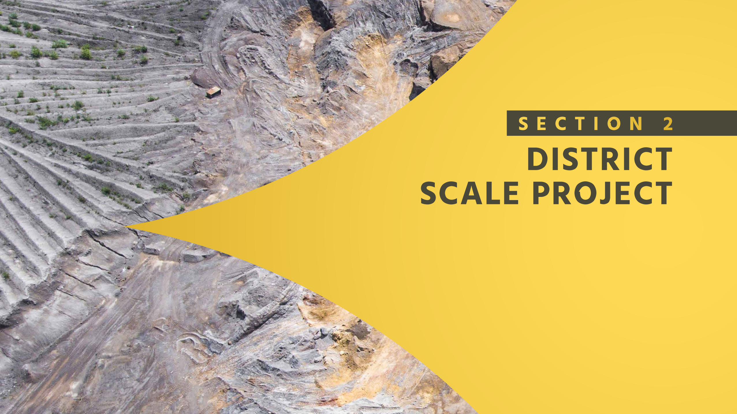
S E C T I O N 2
DISTRICT SCALE PROJECT

• Project covers over 85 km of strike length on the JBP and Appleton Fault Zones
• Initially drilled by Noranda (1980’s) and later by Rubicon (2003-2008)
• The geologic setting, age of mineralization and style of high grade gold at Queensway is very similar to Kirkland Lake’s Fosterville mine
• The epizonal genesis of the high grade gold at Fosterville has only recently been understood
• Queensway high grade appears to have the same epizonal genesis as the high grade Swan zone at Fosterville
QUEENSWAY GOLD PROJECTDISTRICT SCALE
-10-

• The Dog Bay Line (DBL) is a significant suture formed at the closing of the Iapetus Ocean and can be found on both sides of the Atlantic Ocean
• New Found Gold Corp identified this structure for its significant gold potential and consolidated land holdings over a 85 km segment of the structure in Newfoundland
• A number of large gold systems have been found along these major suture zones including:
• Dalradian Gold – Curraginalt Deposit – Ireland (> 6.0 Moz)• Marathon Gold – Valentine Lake Deposit – Newfoundland
(>4.2Moz Au)• Oceana Gold – Haile Deposit – North Carolina (> 3.9 Moz Au)
THE DOG BAY SUTURE – HOST TO LARGE GOLD DEPOSITS
CLOSING OF THE IAPETUS OCEAN
-11-

Queensway Project covering the greatest concentration of gold showings and occurrences in Newfoundland
Timmins Kirkland Lake
St. Johns
Malartic
Val d’Or
Rouyn Noranda
• Recent work by the Geological Survey of Canada comparing structural gold controls of the Abitibi to major orogenic structural controls in Newfoundland
• NFGC has focused on the Dog Bay Line a major thrust fault created at the closing of the Iapetus ocean
• NFGC controls property covering a roughly 85 km length of this fault containing one of the highest concentration of gold showings and occurrences in the province of Newfoundland
• In comparison this would exceed the length of the Larder Cadillac Fault Zone between Kirkland Lake and Rouyn-Noranda
GSC COMPARISION OF ABITIBI AND NEWFOUNDLAND STRUCTURAL CONTROLS
Bleeker, W. and Honsberger, I., 2018. Orogenic comparison of structurally controlled gold systems of the Abitibi greenstone belt and central Newfoundland Appalachians: Implications for Newfoundland gold potential and recurring tectonic drivers of gold mineralization. Geological Survey of Canada. P. 66
-12-

Regional Mag-EM composite
• Shows considerable homogeneity of sedimentary rocks over the property
• Interesting, well defined features in the southern third of the property
• Major contacts well defined
• Few potential large-scale fold
RECENT GEOPHYSICAL DATAHOST SEDIMENTARY PACKAGE
-13-
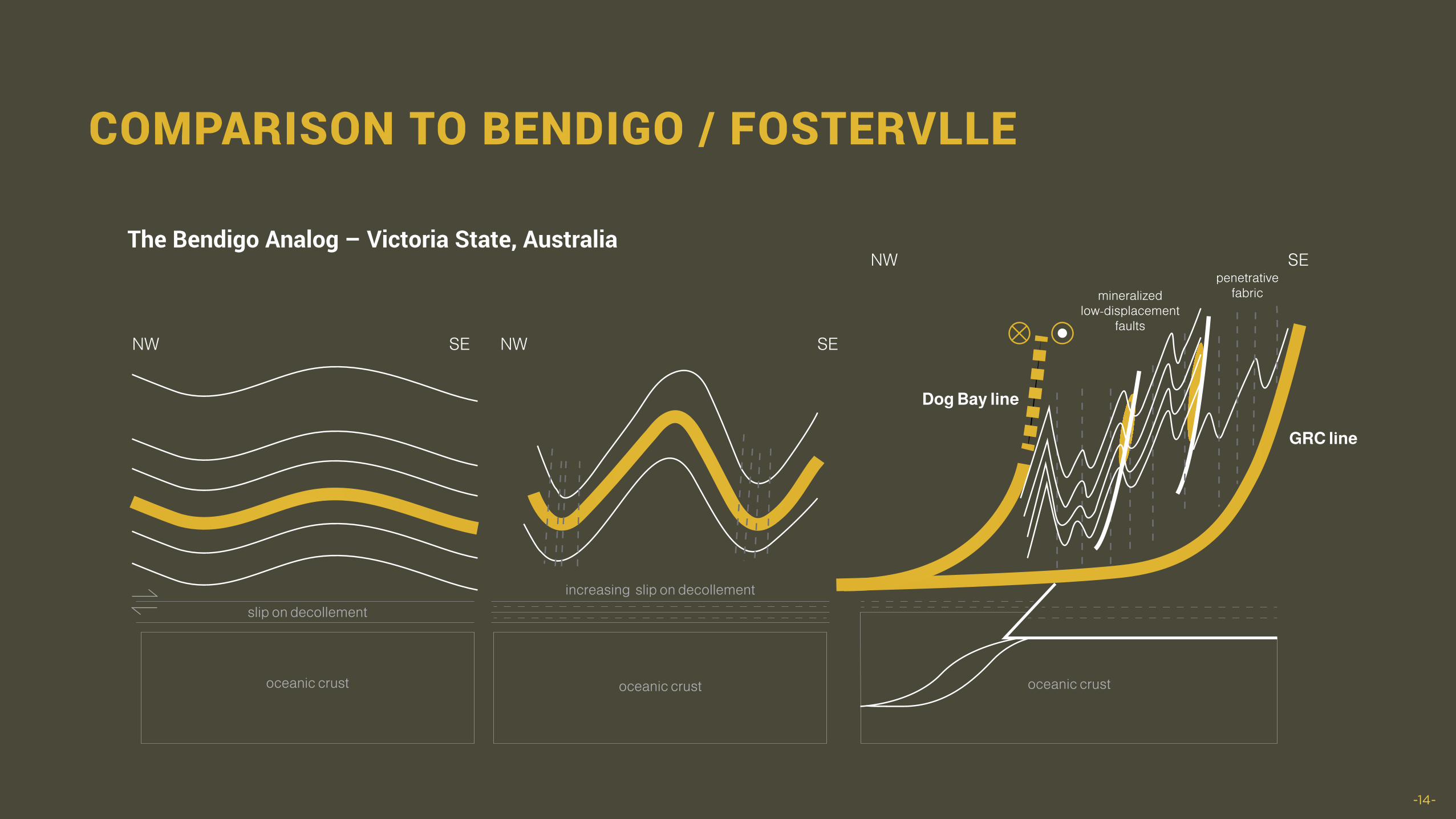
COMPARISON TO BENDIGO / FOSTERVLLE
The Bendigo Analog – Victoria State, Australia
-14-
slip on decollementincreasing slip on decollement
oceanic crust oceanic crust oceanic crust
mineralizedlow-displacement
faults
penetrativefabric
NW SE NW SE
NW SE
Dog Bay line
GRC line
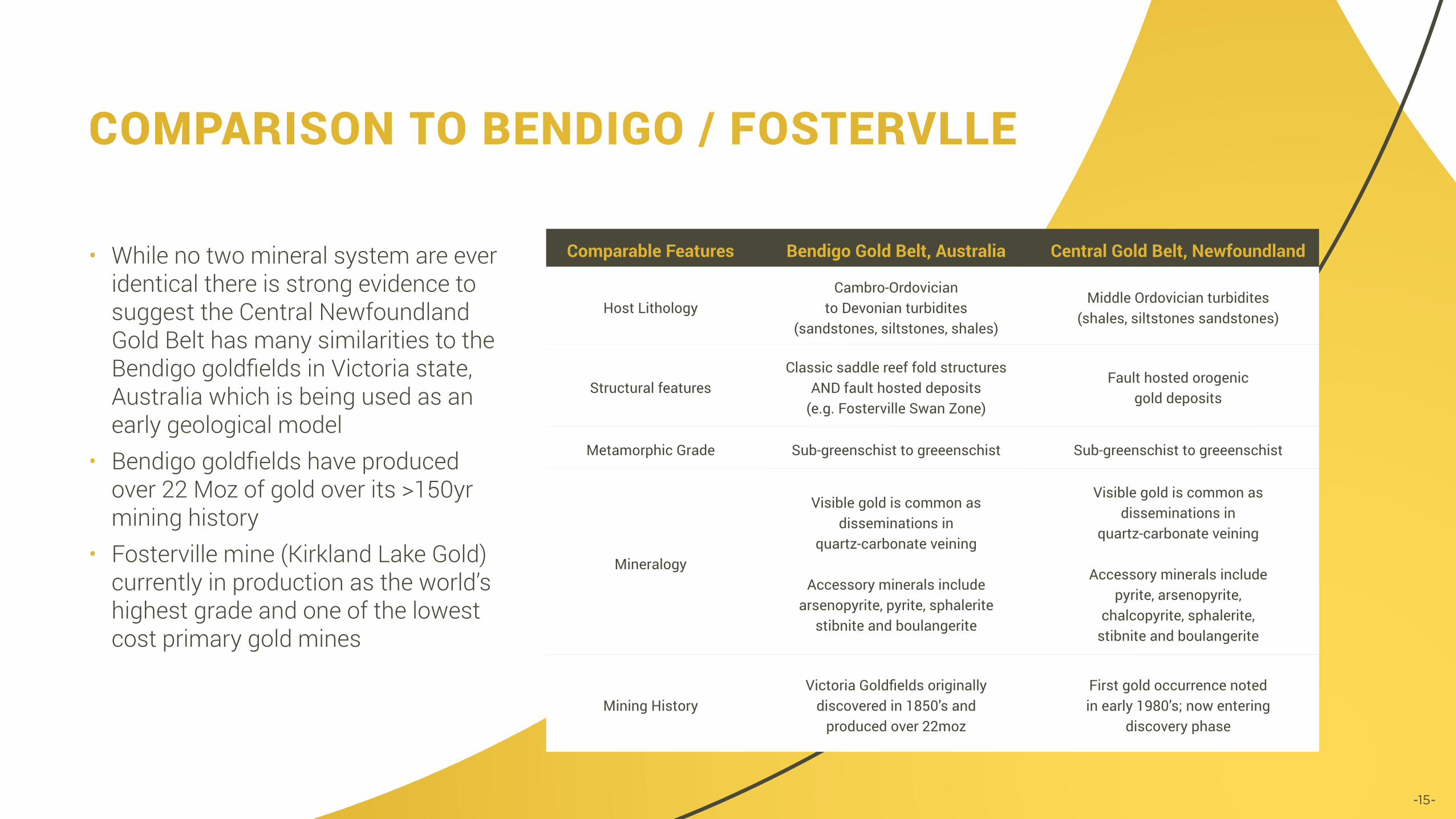
• While no two mineral system are ever identical there is strong evidence to suggest the Central Newfoundland Gold Belt has many similarities to the Bendigo goldfields in Victoria state, Australia which is being used as an early geological model
• Bendigo goldfields have produced over 22 Moz of gold over its >150yr mining history
• Fosterville mine (Kirkland Lake Gold) currently in production as the world’s highest grade and one of the lowest cost primary gold mines
COMPARISON TO BENDIGO / FOSTERVLLE
Comparable Features Bendigo Gold Belt, Australia Central Gold Belt, Newfoundland
Host LithologyCambro-Ordovician
to Devonian turbidites (sandstones, siltstones, shales)
Middle Ordovician turbidites (shales, siltstones sandstones)
Structural features Classic saddle reef fold structures
AND fault hosted deposits (e.g. Fosterville Swan Zone)
Fault hosted orogenic gold deposits
Metamorphic Grade Sub-greenschist to greeenschist Sub-greenschist to greeenschist
Mineralogy
Visible gold is common as disseminations in
quartz-carbonate veining
Accessory minerals include arsenopyrite, pyrite, sphalerite
stibnite and boulangerite
Visible gold is common as disseminations in
quartz-carbonate veining
Accessory minerals include pyrite, arsenopyrite,
chalcopyrite, sphalerite, stibnite and boulangerite
Mining HistoryVictoria Goldfields originally
discovered in 1850’s and produced over 22moz
First gold occurrence noted in early 1980’s; now entering
discovery phase
-15-

-16-
• In 2018 an ambitious regional scale till sampling program was completed targeting a 60 Km strike length of the southern extension of the Appleton and JBP Fault Zone along a 2 x 2 km grid
• A secondary detailed till survey was completed along a section of the Appleton Fault Zone containing numerous gold showings, strong magnetic signature and limited exploration along a 500 x 500 m grid
• Thin glacial till throughout the project area results in a strong correlation between glacial till and bedrock gold anomalies
• The phase 1 program has outlined 6 broad areas of anomalous gold in till – none of which correspond to known gold showings
• A detailed phase 2 regional till program is planned for 2020
QUEENSWAY SOUTH PROJECTGEOCHEMISTRY

• Unlike other regions of Canada, prospecting, geological surveys and reports of gold mineralization did not begin in earnest until the late 1980’s
• Central Newfoundland was under populated (largely unpopulated) during most of the 16th-20th century. WW2 spawned the development of Gander initially as a US air force base. Gander has now grown to a population of 14,000
• Until WW2 most of the Newfoundland population lived on the coast in fishing villages and rarely were drawn inland, access to villages was typically by water and roads were highly variable
• Newfoundland (a dominion of Britain) joined Canada in 1949 after WW2• The Reid Lots covered much of interior newfoundland for the 19-20th century closing the area to exploration• Gold exploration in central Newfoundland went from a single known gold occurrence in the early 1980’s
to 15 occurrences in the late 1980’s, and now there are dozens of known occurrences• The Dunnage zone / Central Newfoundland Gold Belt is now approaching its discovery phase • Despite multiple occurances of high grade gold the Queensway Project area was largely open for staking
in early 2015 when New Found Gold began its property acquisition program
WHY SO UNDER EXPLORED?
-17-

-18-
S E C T I O N 3
QUEENSWAY NORTH PROJECT AREA

-19-
The Queensway project covers two prominent NE trending faults that cross the property which are the vital fluid conduit allowing for the formation of gold deposits. The two fault zones are geologically best defined in the northern portion of the property but projected with geophysics to extend along the entire project. JBP Fault Zone
• Sedimentary hosted quartz vein gold system identified over 3 Km strike
• Total of 9,880 m (54 drill holes)• Open along strike and down dipAppleton Fault Zone
• Auriferous quartz veins hosted within shale and greywacke identified over a 5 Km strike length
• Total of 11,610m (142 drill holes)• The Knob deposit contains a historical resource of
78,000 oz. Au @ 10.3 g/t by Noranda*• Open along strike and down dip
QUEENSWAY NORTH – APPLETON AND JBP FAULT ZONES
-20-
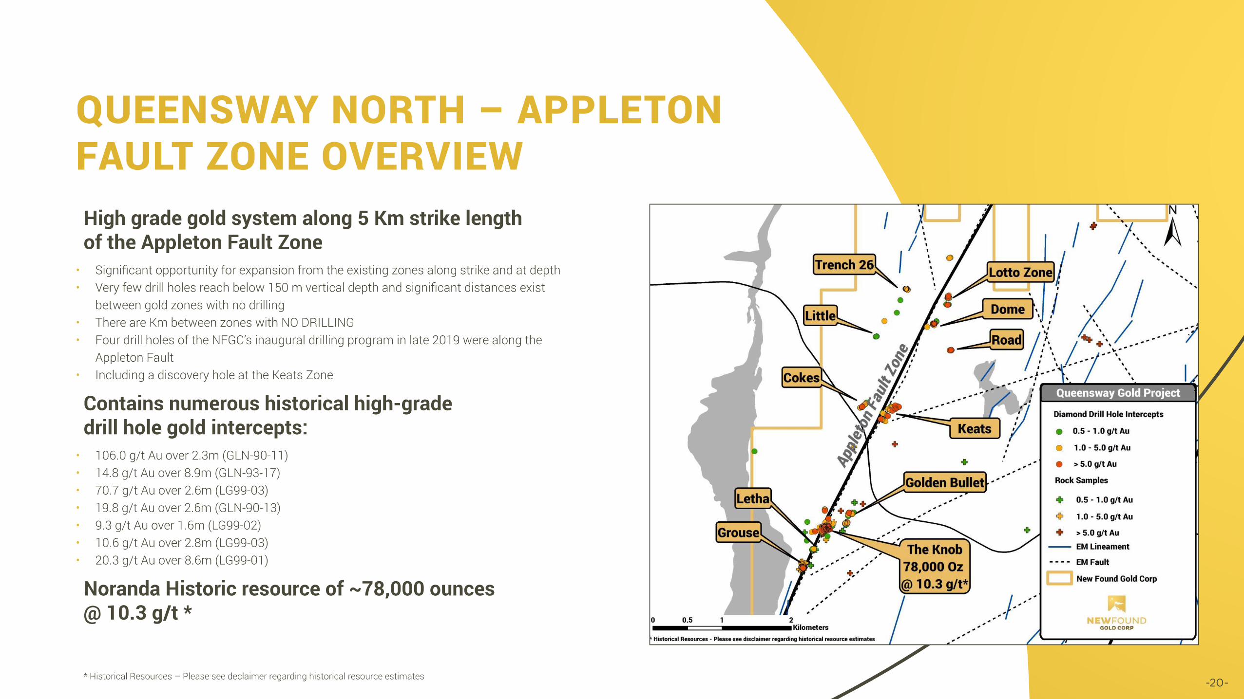
High grade gold system along 5 Km strike length of the Appleton Fault Zone
• Significant opportunity for expansion from the existing zones along strike and at depth• Very few drill holes reach below 150 m vertical depth and significant distances exist
between gold zones with no drilling• There are Km between zones with NO DRILLING• Four drill holes of the NFGC’s inaugural drilling program in late 2019 were along the
Appleton Fault • Including a discovery hole at the Keats Zone
Contains numerous historical high-gradedrill hole gold intercepts:
• 106.0 g/t Au over 2.3m (GLN-90-11)• 14.8 g/t Au over 8.9m (GLN-93-17)• 70.7 g/t Au over 2.6m (LG99-03)• 19.8 g/t Au over 2.6m (GLN-90-13)• 9.3 g/t Au over 1.6m (LG99-02)• 10.6 g/t Au over 2.8m (LG99-03)• 20.3 g/t Au over 8.6m (LG99-01)
Noranda Historic resource of ~78,000 ounces @ 10.3 g/t *
QUEENSWAY NORTH – APPLETON FAULT ZONE OVERVIEW
* Historical Resources – Please see declaimer regarding historical resource estimates

• Multiple high grade surface samples, channel samples and drill intercepts over an approximately 3 km x 2 km area
• Note the location of New Found Gold’s discovery hole 1 at bottom center
APPLETON FAULT ZONE - NORTH
-21-

-22-
• The first modern exploration at Queensway was by Noranda in the 1980’s. They reported a resource at the Knob Zone (see map) of 78,000 oz at 10.3 g/t Au
• The Fosterville epizonal high grade model was not understood at that time
• This genesis of mineralization results in very high grade gold in relatively small volumes of rock. It requires narrow spaced drilling to follow up and trace high grade intercepts, as at Fosterville’s Swan zone
• This strategy has not been pursued before at Queensway
APPLETON FAULT ZONE - SOUTH
* Historical Resources – Please see declaimer regarding historical resource estimates

-23-
High grade gold system along 3 Km strike length of the JBP Fault Zone
• Significant opportunity for expansion from the existing zones along strike and at depth• Very few drill holes reach below 100 m vertical depth and significant distances exist
between gold zones with no drilling• Most of the drilling has occurred along 3 Km segment out of a potential 15 Km in the
northern part of the Queensway Gold Project• Drilling along the JBP Fault Zone was a primary target of the 2019 drilling program
Significant Historic Drill Intercepts in the H-Pond Prospect from 2004-2006 (32 Holes)
• 16.3 g/t Au over 2.4 m (HP-04-03)• 12.3 g/t Au over 1.1 metres (HP06-35)• 9.79 g/t Au gold over 1.2 metres (HP05-15)• 6.91 g/t Au over 1.9 metres (HP05-11)
Significant Historic Drill Intercepts in the Pocket Pond Prospect from 2004-2008 (15 Holes)
• 12.4 g/t Au over 3.4 metres (HP08-44)• 6.60 g/t Au over 1.7 metres (HP04-07)• 11.1 g/t Au over 11.9 metres (HP08-48)
QUEENSWAY NORTH PROJECT JBP FAULT ZONE OVERVIEW

-24-
S E C T I O N 4
2019NEW FOUND DRILL
PROGRAM
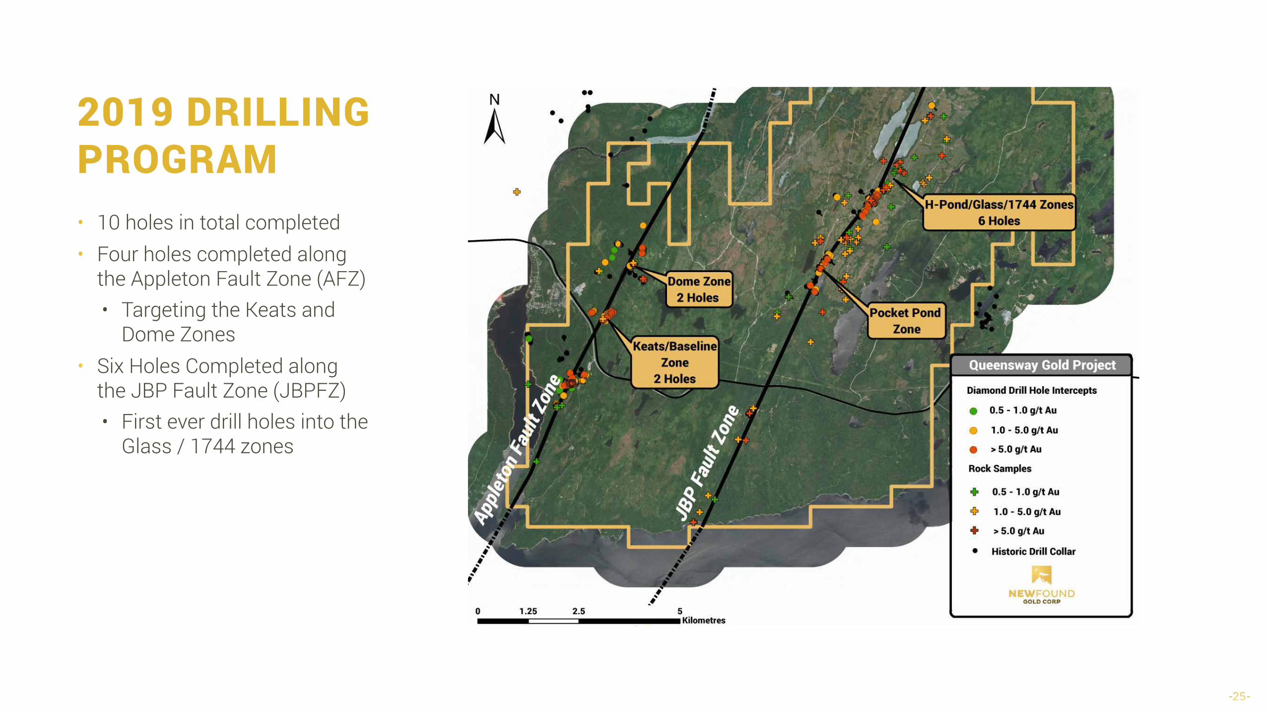
2019 DRILLING PROGRAM
-25-
• 10 holes in total completed• Four holes completed along
the Appleton Fault Zone (AFZ) • Targeting the Keats and
Dome Zones • Six Holes Completed along
the JBP Fault Zone (JBPFZ) • First ever drill holes into the
Glass / 1744 zones

• Five historic drill holes have targeted the Keats Baseline zone along 300m strike length
• Only two holes of the ten drilled in NFGC’s 2019 program were drilled into the Keat’s Zone target
• Each of the five holes have intersected high grade gold mineralization within a pervasive low grade halo
• The low grade halo of gold mineralization (~0.2-0.7g/t Au) is over 100m wide starting near surface
• Strong indications of structurally controlled fault and gold system
• Historic high grade grab samples from this zone are up to 1,869 g/t Au
• Given the historic success this zone was a tier 1 target of the inaugural drill program
KEATS ZONE DRILLING
-26-

KEATS ZONEDISCOVERY HOLE NFGC-19-01
-27-
• Vertical Cross Section of Keats Zone showing hole NFGC-19-01
• Zone is near to vertical showing consistent zone width
• Green are planned Holes
Projection of Baseline FaultQuartz Fill Zone

-28-
NFGC-19-01 ASSAY INTERVAL RESULTSReported intercept is outlined by a 3.0g/t cut-off
Drill core angles indicate the zone to be approximately 70% of the reported intercept width
Hole ID Sample# From To M Au (g/t) Reported IntervalsNFGC-19-01 X943088 89.00 90.00 1.00 0.13
NFGC-19-01 X943089 90.00 91.00 1.00 0.76
NFGC-19-01 X943091 91.00 92.00 1.00 0.23
NFGC-19-01 X943092 92.00 93.00 1.00 0.17
NFGC-19-01 X943093 93.00 94.00 1.00 0.11
NFGC-19-01 X943094 94.00 95.00 1.00 0.28
NFGC-19-01 X943095 95.00 96.00 1.00 1.28
NFGC-19-01 X943096 96.00 97.00 1.00 3.80
92.86 g/t Au over 19.0 metres
NFGC-19-01 X943097 97.00 98.00 1.00 7.71
NFGC-19-01 X943098 98.00 99.00 1.00 5.42
NFGC-19-01 X943099 99.00 100.00 1.00 5.49
NFGC-19-01 X943101 100.00 101.00 1.00 2.89
NFGC-19-01 X943102 101.00 102.00 1.00 2.01
NFGC-19-01 X943103 102.00 103.00 1.00 1.72
NFGC-19-01 X943104 103.00 104.00 1.00 2.42
NFGC-19-01 X943105 104.00 105.00 1.00 2.18
NFGC-19-01 X943106 105.00 105.50 0.50 29.50
285.15 g/t Au over 6.0 metres
NFGC-19-01 X943107 105.50 106.50 1.00 960.30
NFGC-19-01 X943108 106.50 107.50 1.00 94.00
NFGC-19-01 X943109 107.50 108.50 1.00 437.00
NFGC-19-01 X943111 108.50 109.50 1.00 188.70
NFGC-19-01 X943112 109.50 110.00 0.50 14.00
NFGC-19-01 X943113 110.00 110.50 0.50 2.70
NFGC-19-01 X943114 110.50 111.00 0.50 15.65
NFGC-19-01 X943115 111.00 112.00 1.00 3.08
NFGC-19-01 X943116 112.00 113.00 1.00 2.14
NFGC-19-01 X943117 113.00 114.00 1.00 0.85
NFGC-19-01 X943118 114.00 115.00 1.00 13.70
NFGC-19-01 X943119 115.00 115.50 0.50 1.79
NFGC-19-01 X943121 115.50 116.00 0.50 0.03
NFGC-19-01 X943122 116.00 117.00 1.00 0.19
NFGC-19-01 X943123 117.00 117.50 0.50 0.22
NFGC-19-01 X943124 117.50 118.50 1.00 2.33

NFGC-19-01 CORE & MINERALIZATION
• Very significant zone intersected in NFGC-19-01 from ~93 to 118m
• Visible gold is seen in numerous locations throughout the intercept indicated by the orange markers
• Significant sulphide mineralization (pyrite, arsenopyrite) up to 10% is found in the host shale between three major vein sets
• Veins carry trace chalcopyrite, boulangerite and disseminated visible gold
• The zone occupies a broad fault zone with individual fault gouge zones up to 60cm and several lesser structures
• Lower grade halo surrounds very high grade interval similar to Swan Zone at Fosterville
-29-
-30-
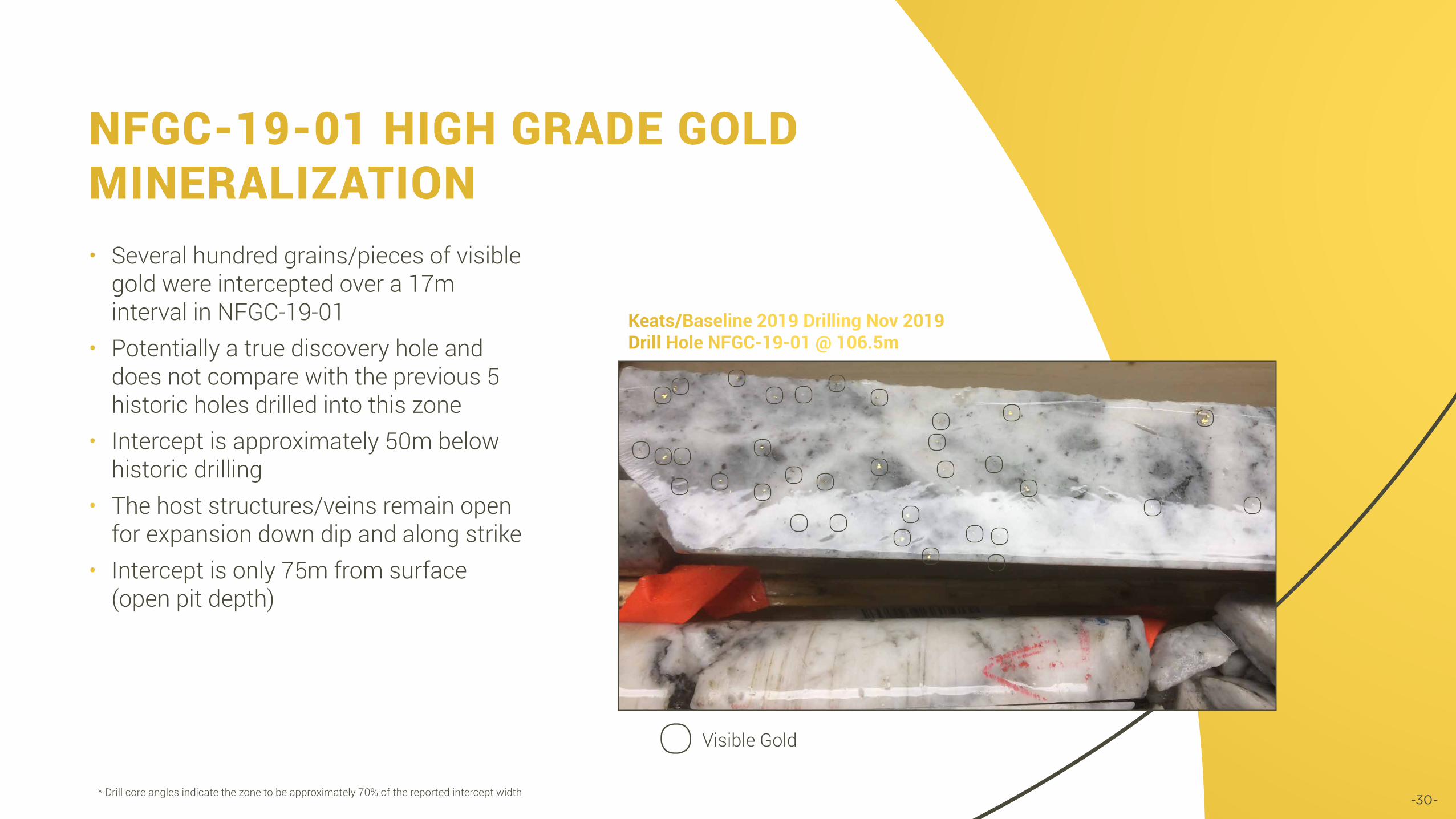
• Several hundred grains/pieces of visible gold were intercepted over a 17m interval in NFGC-19-01
• Potentially a true discovery hole and does not compare with the previous 5 historic holes drilled into this zone
• Intercept is approximately 50m below historic drilling
• The host structures/veins remain open for expansion down dip and along strike
• Intercept is only 75m from surface (open pit depth)
NFGC-19-01 HIGH GRADE GOLD MINERALIZATION
* Drill core angles indicate the zone to be approximately 70% of the reported intercept width
Keats/Baseline 2019 Drilling Nov 2019Drill Hole NFGC-19-01 @ 106.5m
Visible Gold

COMPARISON TO THE FOSTERVILLE SWAN ZONE
Left, core from the Keats zone, Queensway gold project; right, core from the Eagle zone, Fosterville mine. Comparison of intense quartz stock work with relict black shale fragments from each deposit. Specks of visible gold are
present in quartz veins and their selvages. Gray patches contain fine grained antimony sulfides, boulangerite on left and stibnite on right.
Left, core from the Keats zone, Queensway gold project; right, hand specimen from the Eagle zone, Fosterville mine. Comparison of quartz veining displaying
relict banding from each deposit. Dark material at the bottom is relict shaley material. Such banding is probably an original texture resulting from open space filling of quartz sulfides and gold at the time of deposition. Open space filling is
indicative of a shallow level of deposition for both deposits.-31-

COMPARISON TO THE FOSTERVILLE SWAN ZONE
Left, core from Keats zone, Queensway gold project; right, core from the Eagle zone, Fosterville mine. Comparison of vein quartz displaying numerous vugs, or small cavities, lined with quartz crystals from each deposit. Native gold is also
visible in each sample. Such open space cavities are indicative of a shallow level of deposition for both deposits.
Left, core from Keats zone, Queensway gold project; right, core from the Eagle zone, Fosterville mine. Comparison of gray and white quartz vein material with
numerous small specks of native gold from each deposit. Grey specks are mostly antimony minerals, boulangerite on the left and stibnite on the right.
Some gray flecks are particles of black shale caught up in quartz. Such fine gold particles likely formed through rapid precipitation of gold in a shallow epizonal
regime within an orogenic system, an indication of a shallow level of deposition for both deposits.
-32-
-33-
S E C T I O N 5
GEOLOGIC INTERPRETATIONS
-34-
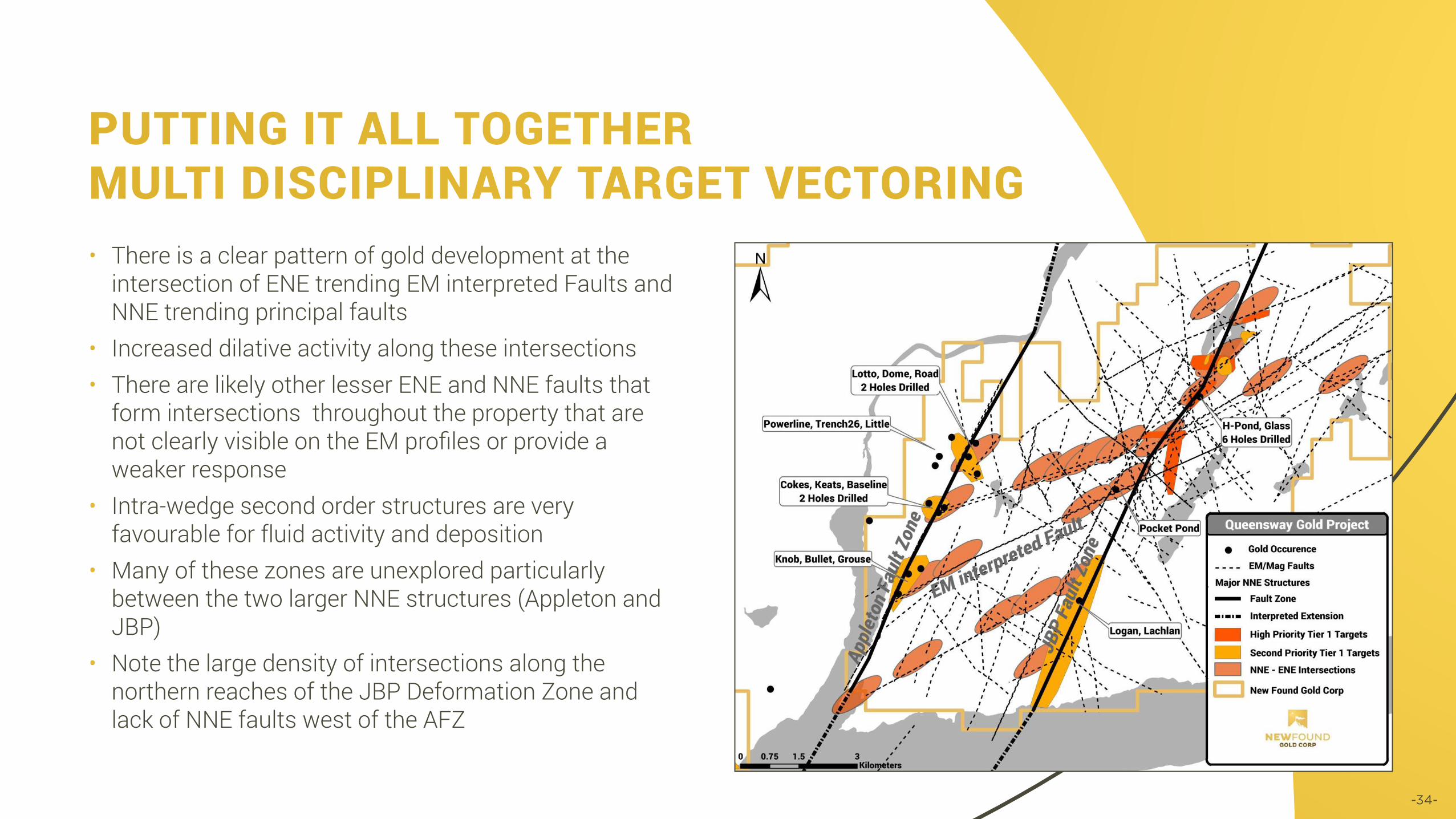
• There is a clear pattern of gold development at the intersection of ENE trending EM interpreted Faults and NNE trending principal faults
• Increased dilative activity along these intersections • There are likely other lesser ENE and NNE faults that
form intersections throughout the property that are not clearly visible on the EM profiles or provide a weaker response
• Intra-wedge second order structures are very favourable for fluid activity and deposition
• Many of these zones are unexplored particularly between the two larger NNE structures (Appleton and JBP)
• Note the large density of intersections along the northern reaches of the JBP Deformation Zone and lack of NNE faults west of the AFZ
PUTTING IT ALL TOGETHERMULTI DISCIPLINARY TARGET VECTORING

STRUCTURAL INTERPRETATION
Traditional Targeting
• Over 1278 new structural measurements taken property wide to better understand faults, fabrics and veining.
• There is a pattern of gold development at the intersection of ENE trending EM interpreted Faults and NNE trending principal faults
• Increased dilative activity along these intersections is likely • There are likely other lesser ENE and NNE faults that form
intersections throughout the property that are not clearly visible on the EM profiles or provide a weaker response
• Intra-wedge second order structures are very favourable for fluid activity and mineral deposition
• These zones can cause local interference with bedding planes
• ENE-trending dextral shear zones, subsequent to S1 development
• Secondary conjugate set of NNW-trending sinistral shear zones
• Typical evolution of deformation accommodation
Late D1: regional dextral transpression
-35-
-36-
S E C T I O N 6
QUEENSWAY EXPLORATION
PLANS AND BUDGETS

PLANNED 2020 EXPLORATION
• Substantial follow up drilling around prior high grade intersections, some close spaced to define high grade epizonal gold mineralization
• Drill testing of traditionally generated and machine learning targets outside of known areas
• Use knowledge of the Phase 1 program to initiate a more detailed drilling program (not definition drilling but defining the scale of resource systems; aka inferred drilling)
• Continued development of the structural model• Investigate structural relationships and mineralizing
events across the Queensway North, surface and drill core• Conduct surface field work at Queensway South, early
stage data collection and advanced target testing (trenching, drilling)
Phase 1 Item Units TotalDrilling 16,000 $2,880,000Airborne Gravity $875,000Tills 750 $750,000Trenching 20 $200,000N Queensway Traverse 1200 $400,000G&A $700,000
TOTAL $5,805,000
Phase 2 Item Units TotalDrilling 50,000 $9,000,000Tills 250 $250,000Trenching 25 $250,000G&A $700,000
TOTAL $10,200,000
-37-

EXPLORATION TIMELINE
2016-2017NOV 2016JUL 2017FEB 2018
Nov 2019 MAR 2020 MAY 2020 JUN 2020 JAN 2021
Completed 9 separate property
transactions along with
staking to form the Queensway
Project
Planned 16,000m diamond drilling program at JBP
and Appleton Fault Zones
Initiate Phase 2 Exploration
Plan
Completed detailed till sampling program
covering the JBP Fault Zone
Planned expanded phase
2 regional till program to cover
additional 750 sites / systematic surface mapping
and sampling
Completed a property wide
VTEM magnetic and EM survey covering 821
Km2
Completed a 1,950m diamond drilling program
at JBP and Appleton Fault
Zone
Planned airborne gravity to test
Queensway North
-38-
Completed a regional scale till survey to sample over 750 location