Embed Size (px)
Citation preview

Cambridgeshire Flood Risk Management Partnership
Ely Surface Water Management Plan
Detailed Assessment and Options Appraisal Report
Final


Ely Surface Water Management Plan—Detailed Assessment and Options Appraisal Report
Hyder Consulting (UK) Limited-2212959 c:\tga74494\documents\cambs swmp\ely\draft outputs\draft report issued\5301-ua002163-bmr-10_ely_swmp_report_rg.docx
Hyder Consulting (UK) Limited
2212959
Aston Cross Business Village 50 Rocky Lane Aston Birmingham B6 5RQ United Kingdom
Tel: +44 (0)121 333 4466
Fax: +44 (0)121 333 4275
www.hyderconsulting.com
Cambridgeshire Flood Risk Management Partnership
Ely Surface Water Management Plan
Detailed Assessment and Options Appraisal Report
Draft
Authors T Lester
Checkers L Foster
Approver R. Gunasekara
Report No 5301-UA002163-BMR-01
Date April 2012
Front Cover: Surface Water Drain near Tennyson Place, Ely, Renuka Gunasekara, Hyder Consulting PLC
This report has been prepared for the Cambridgeshire Flood Risk Management Partnership in accordance
with the terms and conditions of appointment for the Surface Water Management Plan dated March 2011.
Hyder Consulting (UK) Limited (2212959) cannot accept any responsibility for any use of or reliance on the
contents of this report by any third party.

Ely Surface Water Management Plan—Detailed Assessment and Options Appraisal Report
Hyder Consulting (UK) Limited-2212959 Page ic:\tga74494\documents\cambs swmp\ely\draft outputs\draft report issued\5301-ua002163-bmr-10_ely_swmp_report_rg.docx
CONTENTS
1 Introduction ....................................................................................... 1
1.1 Terms of Reference .......................................................................... 1
1.2 Surface Water Management Plans .................................................... 1
1.3 Partnership Establishment ................................................................. 2
1.4 Policy Framework ............................................................................. 3
1.5 Surface Water Flooding ..................................................................... 4
1.6 Sustainable Drainage Systems (SuDS) .............................................. 4
2 Scope of the SWMP .......................................................................... 7
2.1 Aims and Objectives ......................................................................... 7
2.2 Drivers for Change ............................................................................ 9
2.3 Geographic Extent ............................................................................ 9
2.4 Methodology ................................................................................... 10
3 Evidence Base ................................................................................ 12
3.1 Previous Studies ............................................................................. 12
3.2 Historical Flooding........................................................................... 15
3.3 Flood Incident Register ................................................................... 16
3.4 Sources of Flooding ........................................................................ 17
3.5 Potential Indicators of Surface Water Flood Risk .............................. 22
3.6 Maintenance Regimes ..................................................................... 25
4 Model Development ........................................................................ 27
4.1 Model Evolution .............................................................................. 27
4.2 Hydraulic Modelling - Common Principles ........................................ 28
4.3 Stage 1 - Hydrological Analysis/Bare Earth Modelling ....................... 30
5 Wetspot Selection & Prioritisation .................................................... 33
5.1 Approach ........................................................................................ 33
5.2 Stage 2 – Identification of Potential Wetspot Areas........................... 33
6 Detailed Assessment....................................................................... 34
6.1 Stage 3 Detailed Modelled Development.......................................... 34
6.2 Model Results Analysis ................................................................... 35
6.3 Model Verification ........................................................................... 39
6.4 Model Assumptions ......................................................................... 40
6.5 Model Sensitivity ............................................................................. 40
6.6 Model Outputs ................................................................................ 42
7 Engineering Options Identification & Assessment ............................ 44
7.1 Measures Identification ................................................................... 44
7.2 Ely Engineering Measures and Options ........................................... 46
Ely Surface Water Management Plan—Detailed Assessment and Options Appraisal Report
Hyder Consulting (UK) Limited-2212959 Page iic:\tga74494\documents\cambs swmp\ely\draft outputs\draft report issued\5301-ua002163-bmr-10_ely_swmp_report_rg.docx
7.3 Ely Engineering Option Combinations .............................................. 51
8 Economic Appraisal ........................................................................ 53
8.1 Introduction ..................................................................................... 53
8.2 Damages Assessments - Assumptions ............................................ 61
8.3 Damages Assessment – Exclusions ................................................ 62
8.4 Option C2 – Rain Gardens .............................................................. 63
9 Summary ........................................................................................ 64
9.1 Key Surface Water Flooding Issues ................................................. 64
9.2 Preferred Options For Further Investigation...................................... 65
9.3 Benefits of SWMP ........................................................................... 66
10 Next Steps ...................................................................................... 68
10.1 Surface Water Management Action Plan – Preparation,
Implementation and Monitoring ........................................................ 68
10.2 Engage with Stakeholders ............................................................... 69
11 References ..................................................................................... 71
Appendices
Appendix A Glossary
Appendix B Partnership Arrangements and Stakeholder Engagement
Appendix C Data Collection Process and Data Register
Appendix D Flood Incident Register
Appendix E Hydrological Parameters
Appendix F Engineering Option Details
Appendix G Detailed Modelling Results
Appendix H Schematics and Preferred Option Modelling
Appendix I Sensitivity Analysis Results

Ely Surface Water Management Plan—Detailed Assessment and Options Appraisal Report
Hyder Consulting (UK) Limited-2212959 Page iic:\tga74494\documents\cambs swmp\ely\draft outputs\draft report issued\5301-ua002163-bmr-10_ely_swmp_report_rg.docx
Report Version Control Schedule
Version Date of
Issue
Document Reference Status
0.1 23/01/2012 5301-UA002163-BMR-00_Ely Detailed SWMP Report
Draft
0.2 05/04/2012 5301-UA002163-BMR-01_Ely_SWMP_Report
Final

Ely Surface Water Management Plan—Detailed Assessment and Options Appraisal Report
Hyder Consulting (UK) Limited-2212959 Page 1c:\tga74494\documents\cambs swmp\ely\draft outputs\draft report issued\5301-ua002163-bmr-10_ely_swmp_report_rg.docx
1 Introduction
1.1 Terms of Reference
Hyder Consulting (UK) Limited (HCL) was appointed to produce detailed Surface Water
Management Plans (SWMP) for the entire county, which are to be completed by April 2015. The
first phase of work was the Countywide Strategic Assessment report1, which was completed in
April 2011.
HCL was then asked to undertake the detailed surface water management assessment of Ely,
as it was identified as being one of the highest priority wetspots for Cambridgeshire County
Council. This SWMP is formed from the outputs of all the stages of the study, from a strategic
assessment of the overall study area through to flood risk mitigation measures optioneering of
the prioritised wetspots. The options assessed at this stage provide a theoretical assessment of
how best to mitigate flood risk in the wetspot subject to overcoming key engineering, financial
and environmental constraints. This provides an analysis of where investment could be directed
in the future if finance is available.
The Ely Detailed SWMP was completed in April 2012, and the findings are detailed in this
report. It is recommended that this report be read alongside the Countywide Strategic
Assessment report mentioned above.
1.2 Surface Water Management Plans
The wide scale flooding experienced during 2007 precipitated the publication of the Pitt Review2
which contained a large number of recommendations for Government to consider. The key
recommendation in the Pitt Review with respect to surface water management is
Recommendation 18, reproduced below, which in turn refers to Planning Policy Statement 25
Development and Flood Risk (PPS25)3.
Recommendation 18: “Local Surface Water Management Plans, as
set out in PPS25 and coordinated by local authorities, should
provide the basis for managing all local flood risk.“
Surface Water Management Plans (SWMPs) are referred to in
Planning Policy Statement 25 (PPS25) as a tool to manage surface
water flood risk on a local basis by improving and optimising
coordination between relevant stakeholders. SWMPs will build on
Strategic Flood Risk Assessments (SFRAs) and provide the vehicle
for local organisations to develop a shared understanding of local
flood risk, including setting out priorities for action, maintenance
needs and links into local development frameworks and emergency
plans.
Guidance on the production of SWMPs was published in March 20104 informed by the
Integrated Urban Drainage (IUD) Pilot Studies carried out under the Government’s Making
Space for Water (MSfW)5 strategy.
A SWMP outlines the preferred strategy for the management of surface water in a given location
and the associated study is carried out in consultation with local partners having responsibility
for surface water management and drainage in that area. The goal of a SWMP is to establish a
long term action plan and to influence future strategy development for maintenance, investment,
planning and engagement.

Ely Surface Water Management Plan—Detailed Assessment and Options Appraisal Report
Hyder Consulting (UK) Limited-2212959 Page 2c:\tga74494\documents\cambs swmp\ely\draft outputs\draft report issued\5301-ua002163-bmr-10_ely_swmp_report_rg.docx
The framework for undertaking a SWMP is illustrated using a wheel diagram, reproduced from
the Defra Guidance³ as shown in Figure 1-1.
Figure 1-1 SWMP Wheel (source Defra Guidance³)
The SWMP process is formed of four principal phases;
� preparation,
� risk assessment,
� options, and
� implementation and review.
This report contains the findings from the preparation stage and the strategic and intermediation
elements of the risk assessment phase. Text boxes at the start of each chapter summarise the
elements of the guidance addressed within the subsequent text.
1.3 Partnership Establishment
The formation of partnerships has an important role in the undertaking of a SWMP, and is
required under Defra’s SWMP guidance documentation. The SWMP guidance details the

Ely Surface Water Management Plan—Detailed Assessment and Options Appraisal Report
Hyder Consulting (UK) Limited-2212959 Page 3c:\tga74494\documents\cambs swmp\ely\draft outputs\draft report issued\5301-ua002163-bmr-10_ely_swmp_report_rg.docx
identification of those partners / organisations that should be involved and what their roles and
responsibilities should be.
It recommends the formation of an engagement plan, which should include objectives for the
individual partners, and detail how and at what stages of the SWMP the engagement with
stakeholders should take place.
Appendix B describes the partners, their roles and responsibilities and their objectives as
required by the SWMP guidance.
1.4 Policy Framework
1.4.1 Flood Risk Regulations 2009
The Flood Risk Regulations 2009 (FRR) transpose the European Floods Directive 2007/60/EC
into English and Welsh law and bring together key partners to manage flood risk from all
sources and in doing so reduced the consequences of flooding on key receptors. Local
authorities are assigned responsibility for management of surface water flooding.
As part of the ongoing cycle of assessments, mapping and planning, the FRR requires the
undertaking of a PFRA. National guidance was published by the Environment Agency (EA) in
December 20106. The requirements of the FRR have also been used to shape this report and to
inform the content of the Council’s PFRA report to the Government produced by HCL.
Under Flood Risk Regulation 19-1 a Lead Local Flood Authority must prepare a flood hazard
map and a flood risk map in relation to each relevant Flood Risk Area, if identified by the PFRA
process. No significant Flood Risk Area has been identified by the EA nationally within
Cambridgeshire, nor the first cycle of the Cambridgeshire PFRA at a local level. However,
depth, velocity and hazard maps (Section 6.6) have been prepared for the Ely SWMP study
area and they will inform Cambridgeshire’s Local Flood Risk Management Strategy
development (see Section 2.1.3) and the second cycle of the PFRA process in six years time.
1.4.2 Flood and Water Management Act 2010
The Flood and Water Management Act places the responsibility for managing the risk of local
floods on the Upper Tier or unitary authorities, as their role as Lead Local Flood Authorities
(LLFAs), but allows for the delegation of flood risk management functions to other statutory
authorities. The Act also seeks to encourage the uptake of Sustainable Drainage Systems
(SuDS) by agreeing new approaches to the management of drainage systems and allowing,
where delegated, for district councils and Internal Drainage Boards (IDBs) to adopt SuDS for
new developments and redevelopments.
1.4.3 Planning Policy Statement 25
Planning Policy Statement 25 (PPS25) requires that new development should not increase flood
risk, and requires developers to design, build and fund the maintenance of SuDS; a SWMP will
support this by informing the Local Planning Authority (LPA) of areas at risk of surface water
flooding ‘and by providing an evidence base to aid the consideration of future development
options.

Ely Surface Water Management Plan—Detailed Assessment and Options Appraisal Report
Hyder Consulting (UK) Limited-2212959 Page 4c:\tga74494\documents\cambs swmp\ely\draft outputs\draft report issued\5301-ua002163-bmr-10_ely_swmp_report_rg.docx
1.4.4 New Planning Policy Framework (NPPF)
The NPPF proposes to review all existing planning policies and to restructure the planning
process7. The aim of this new framework is to make planning more streamlined and
transparent. The NPPF also aims to give local councils more control over local planning with
more emphasis being placed on sustainable local growth.
The consultation period ended on the 17th of October 2011 and the Government’s response to
consultation and the final version due to be published in April 2012.
1.5 Surface Water Flooding
In the context of SWMPs, the technical guidance4 defines surface water flooding as:
� Surface water runoff; runoff as a result of high intensity rainfall when water is ponding or
flowing over the ground surface before it enters the underground drainage network or
watercourse, or cannot enter it because the network is full to capacity, thus causing
flooding (known as pluvial flooding);
� Flooding from groundwater where groundwater is defined as all water which is below the
surface of the ground and in direct contact with the ground or subsoil;
� Sewer flooding; flooding which occurs when the capacity of underground systems is
exceeded due to heavy rainfall, resulting in flooding inside and outside of buildings. Note
that the normal discharge of sewers and drains through outfalls may be impeded by high
water levels in receiving waters as a result of wet weather or tidal conditions;
� Flooding from any watercourse not designated a “Main River”, including culverted
watercourses which receive most of their flow from inside an urban area and perform an
urban drainage function;
� Overland flows from the urban/rural fringe entering the built-up area; and
� Overland flows resulting from groundwater sources.
This report aims to consider surface water flooding issues in Ely as above but it does not
address sewer flooding where it is occurring as a result of operational issues, i.e. blockages and
equipment failure. It should also be noted that the compilation of all historical flooding within the
area does include some flooding due to main rivers, although further investigation of these
occurrences is outside the remit of this report.
Information on Main River Flooding is covered under other strategic planning documents such
as Strategic Flood Risk Assessments, produced by district councils.
1.6 Sustainable Drainage Systems (SuDS)
Sustainable drainage systems are used to manage rainfall run-off from impermeable surfaces.
SuDS encompass a range of techniques which aim to mimic the natural processes of runoff and
infiltration as closely as possible. These techniques can include green roofs, ponds, permeable
paving and soakaways. Any SuDS scheme should integrate with existing drainage systems and
be easily maintainable.
SuDS schemes should be based on a hierarchy of methods termed the ‘SuDS treatment train’
as illustrated in Figure 1-2.

Ely Surface Water Management Plan—Detailed Assessment and Options Appraisal Report
Hyder Consulting (UK) Limited-2212959 Page 5c:\tga74494\documents\cambs swmp\ely\draft outputs\draft report issued\5301-ua002163-bmr-10_ely_swmp_report_rg.docx
Figure 1-2 SuDS Treatment Train
Guidance recommends that the management of surface water runoff should use a combination
of site specific and strategic SuDS measures, encouraging source control where possible to
reduce flood risk and improve water quality. Table 1-1 describes some of the SuDS techniques
that will be considered in the development of the Ely SWMP.

Ely Surface Water Management Plan—Detailed Assessment and Options Appraisal Report
Hyder Consulting (UK) Limited-2212959 Page 6c:\tga74494\documents\cambs swmp\ely\draft outputs\draft report issued\5301-ua002163-bmr-10_ely_swmp_report_rg.docx
Table 1-1 SuDS Techniques (source Ciria8)
Type Description
Balancing Pond A pond designed to attenuate flows by storing runoff during the peak flow and releasing
it at a controlled rate during and after the peak flow has passed. The pond always
contains water. Also known as wet detention pond.
Brown Roof A roof covered with a locally sourced material, its main aim is to partly mitigate any loss
of habitat when new developments are constructed.
Detention Basin A vegetated depression, normally dry except after storm events constructed to store
water temporarily to attenuate flows. May allow infiltration of water to the ground
Filter Strip A vegetated area of gently sloping ground designed to drain water evenly off
impermeable areas and filter out silt and other particulates.
Green Roof A roof with plants growing on its surface, which contributes to local biodiversity. The
vegetated surface provides a degree of retention, attenuation and treatment of
rainwater, and promotes evapotranspiration. Sometimes referred to as a “living” roof.
Infiltration Basin A dry basin designed to promote infiltration of surface water to the ground.
Road Side Rain
Gardens
Where space allows, these can be constructed alongside roads to allow run-off from
roads or pavements to filter slowly through the root system of plants, rather than
entering underground drainage systems.
Permeable
Surface
A surface formed of material that is itself impervious to water but, by virtue of voids
formed through the surface, allows infiltration of water to the sub-base through the
pattern of voids, e.g. concrete block paving.
Rainwater
Harvesting
A system that collects rainwater from where it falls rather than allowing it to drain away.
It includes water that is collected within the boundaries of a property, from roofs and
surrounding surfaces. The harvested water is then re-used in applications where
potable water is not essential.
Swale A shallow vegetated channel designed to conduct and retain water, but may also permit
infiltration; the vegetation filters particulate matter.
SuDS techniques can be divided into two main groups; infiltration based or attenuation based.
Infiltration based SuDS facilitate the discharge of water directly into the ground through soil and
rocks; this is only possible where the underlying geology is permeable enough to allow the
passage of water downwards. Attenuation based SuDS retain water on a site and allow it to
discharge at a prescribed and controlled rate into a watercourse or sewer.
The feasibility for the use of any SuDS technique should be investigated prior to their
installation.

Ely Surface Water Management Plan—Detailed Assessment and Options Appraisal Report
Hyder Consulting (UK) Limited-2212959 Page 7c:\tga74494\documents\cambs swmp\ely\draft outputs\draft report issued\5301-ua002163-bmr-10_ely_swmp_report_rg.docx
2 Scope of the SWMP
Flood Risk Regulations 2009
Define the aims, objectives and purpose of the report
Describe the overall approach and methodology applied
2.1 Aims and Objectives
2.1.1 Study
The final aim of the SWMP study is to produce a long term surface water management Action
Plan for Ely, which, once in place, will be reviewed every 6 years at a minimum.
The objectives of this study are to:
� Map historical flood incident data
� Engage with partners and stakeholders
� Map surface water influenced flooding locations
� Identify surface water flooding wetspot areas
� Assess, compare and prioritise wetspot areas for detailed assessment
� Identify measures, assess options and confirm preferred options for the prioritised
‘wetspots’
� Make recommendations for next steps
A wetspot is defined as being an area susceptible to Surface Water flooding following analysis
of Modelled Surface Water outputs or historical records.
These objectives will be met following the progression of a number of project stages. The first
stage is data collection, involving contact with the varying partner organisations to obtain all

Ely Surface Water Management Plan—Detailed Assessment and Options Appraisal Report
Hyder Consulting (UK) Limited-2212959 Page 8c:\tga74494\documents\cambs swmp\ely\draft outputs\draft report issued\5301-ua002163-bmr-10_ely_swmp_report_rg.docx
relevant information. During this stage the collation of historical and future flooding along with
information on flood receptors and flood consequences will take place.
Once the data collection stage is complete, the surface water flooding information will be
analysed to identify wetspots that have a history of flooding incidents or potentially could be at
risk of future flooding. Those wetspots identified as being at higher risk or priority through
agreed local assessment criteria will then progress forward to the next stages, detailed
assessment and optioneering.
Following the optioneering stage, recommendations for flood alleviation or mitigation will be
considered.
2.1.2 Partnership Working
The Cambridgeshire Flood Risk Management Partnership comprises all the flood risk authorities
in Cambridgeshire, including Cambridgeshire County Council, Cambridge City Council, East
Cambridgeshire District Council, the Environment Agency, Ely Group of Internal Drainage
Boards and Anglian Water. A SWMP Project Management Board was formed as a sub group of
CRMP to steer the production of SWMPs, and they are discussed in more detail in Appendix B.
The CFRMP has developed a Stakeholder Engagement Plan, which will aid in communicating
the work of the partnership to the key stakeholders, and is discussed in further detail in
Section 2.4 of the Countywide SWMP. It is of great importance that collaborative working of this
nature is undertaken in order to share experience and expertise.
2.1.3 Context
Alongside the legislative requirements discussed above this SWMP will support the following
initiatives.
Local Flood Risk Management Strategies
Local Flood Risk Management Strategies9 came into force as part of the Flood and Water
Management Act 2010. As LLFA, CCC must develop a strategy for local flood risk management.
The strategy must be consistent with the National Flood and Coastal Erosion Risk Management
Strategy for England, the regional CFMPs and River Basin Plans, and should be developed and
maintained with consultation from other stakeholders, such as the public and other risk
management authorities.
The strategy must specify:
� the risk management authorities in the authority's area,
� the flood and coastal erosion risk management functions that may be exercised by those
authorities in relation to the area,
� the objectives for managing local flood risk (including any objectives included in the
authority's flood risk management plan prepared in accordance with the Flood Risk
Regulations 2009),
� the measures proposed to achieve those objectives,
� how and when the measures are expected to be implemented,
� the costs and benefits of those measures, and how they are to be paid for,
� the assessment of local flood risk for the purpose of the strategy,
� how and when the strategy is to be reviewed, and
� how the strategy contributes to the achievement of wider environmental objectives.

Ely Surface Water Management Plan—Detailed Assessment and Options Appraisal Report
Hyder Consulting (UK) Limited-2212959 Page 9c:\tga74494\documents\cambs swmp\ely\draft outputs\draft report issued\5301-ua002163-bmr-10_ely_swmp_report_rg.docx
Catchment Flood Management Plan (CFMP)
The Ely study area falls within the area covered by the Great Ouse CFMP, as discussed in
Section 3.1.1. The Action Plan associated with the Great Ouse CFMP, in conjunction with
district wide SFRA’s and this SWMP, will assist in informing the Local Development Framework
process and future flood risk management.
Anglian River Basin Management Plan (RBMP)
The Ely study area falls within the Anglian RBMP. The plan has been prepared under the Water
Framework Directive and is designed to protect, improve and ensure the sustainable use of the
water environment within the Anglian Basin.
2.2 Drivers for Change
The CFRMP are undertaking this SWMP in order to:
� Better understand the risks and consequences of surface water flooding in Ely;
� To meet or significantly assist in meeting some of the requirements on CCC as Lead
Local Flood Authority under the Flood Risk Regulations 2009;
� To meet a number of the requirements of the Flood and Water Management Act
specifically in terms of developing an asset register and producing a local flood risk
management strategy.
It is worth noting that the developed area of Ely is steadily increasing due to a number of
residential developments already constructed, and further developments are planned to North of
Ely. These will have had significant impacts on the natural environment, as greener rural areas
have been replaced in part by housing and commercial developments, roads and other forms of
community infrastructure.
The SWMP process allows the opportunity to enhance the condition of these urbanised
catchments helping to improve the water quality. Additionally, the implementation of the SWMP
and Action Plan can help to provide significant economic and environmental benefits to the
community through better preparation against these potential extreme rainfall events, which to a
large extent has not occurred since this development has occurred.
2.3 Geographic Extent
Flood Risk Regulations 2009
Define the geographic extent of the report and relate to the relevant river basin district and
relevant maps
This SWMP has been undertaken for the cathedral city of Ely. The city lies approximately 14
kilometres to the north east of Cambridge City Centre. Ely is situated on an island of higher
ground within the low lying Fens. Ely has a population of approximately 15,200.
Ely is located within the Anglian River Basin District and the River Great Ouse catchment. It sits
in the north of the East Cambridgeshire District Council area. The study area/ 2D extent
incorporates all of the Ely urban area and incorporates approximately 16.2km², as shown in
Figure 2-1.
Ely Surface Water Management Plan—Detailed Assessment and Options Appraisal Report
Hyder Consulting (UK) Limited-2212959 Page 10c:\tga74494\documents\cambs swmp\ely\draft outputs\draft report issued\5301-ua002163-bmr-10_ely_swmp_report_rg.docx
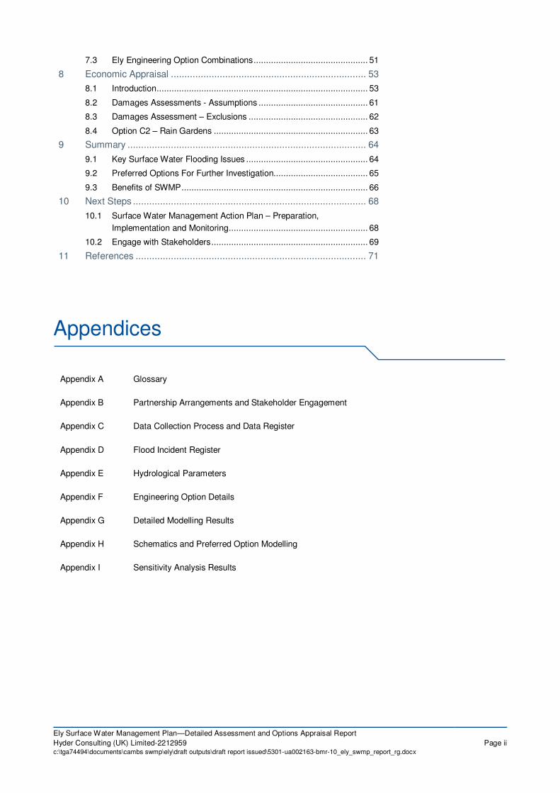
Study Area /2D Model Extent
Figure 2-1 Ely SWMP Study Area © Crown Copyright and database right 2012. All rights
reserved. Ordnance Survey licence number 100026380
The land surrounding Ely is predominantly arable agricultural land. A ridge of higher land
approximately 20-30 m Above Ordnance Datum Newlyn runs through the centre of Ely. The city
is bypassed by the A10 which is a main trunk road connecting several large urban areas within
Cambridgeshire. The urban area to the east ranges from 5 – 8 m above ordnance datum (AOD)
and the area to the west ranges from 1 – 3m AOD. Ordnance Datum or is a vertical datum used
by an ordnance survey as the basis for deriving altitudes on maps.
2.4 Methodology
The methodology used to carry out this SWMP follows the advice set out in the Defra SWMP
guidance4 for the preparation stage and the strategic risk assessment phase. Figure 2-2
illustrates the process carried out to inform this detailed assessment and options appraisal
report, a key output of Ely SWMP. It should be noted that this figure only shows the steps
subsequent to the formal identification of the Ely settlement as a priority wetspot discussed in
the Countywide Strategic SWMP.
Further details on the methodology are discussed throughout the report in the relevant sections.
The work undertaken for the study is also informed by the EA’s PFRA guidance in order to
assist in meeting the obligations of CCC as the Lead Local Flood Authority (LLFA). Information
on the methodology for subsequent phases of the SWMP is set out in Section 10 of this report.

Ely Surface Water Management Plan—Detailed Assessment and Options Appraisal Report
Hyder Consulting (UK) Limited-2212959 Page 11c:\tga74494\documents\cambs swmp\ely\draft outputs\draft report issued\5301-ua002163-bmr-10_ely_swmp_report_rg.docx
Figure 2-2 Overall Approach to Study Methodology
The specific methodology adapted for the Ely study is further explained in Sections 4 to 8.
Collate and map Historic Flood Incident Data
Map surface water influenced historic and future flood locations,
mechanisms and consequences
Undertake Strategic Assessment
Produce List of Initial Wetspot Areas
Consult stakeholders for local knowldge and to obtain missing
data and prioritise wetspots
Recommend Priority Wetspot Areas for Detailed Assessment
Undertake Detailed Assessment and Options Appraisal
Confirm Preferred Options
County wide SWMP
EA – Surface Water
Map and
Areas susceptible to
Surface Water
Flooding Maps
BGS – Groundwater
Vulnerability Maps
National and Local
Information on flood
receptors and
consequence

Ely Surface Water Management Plan—Detailed Assessment and Options Appraisal Report
Hyder Consulting (UK) Limited-2212959 Page 12c:\tga74494\documents\cambs swmp\ely\draft outputs\draft report issued\5301-ua002163-bmr-10_ely_swmp_report_rg.docx
3 Evidence Base
3.1 Previous Studies
As part of this study, it has been critical to identify the links to other local and regional delivery
plans which may influence or be influenced by the SWMP. The SWMP will seek to integrate and
align these plans and processes to provide a clear and robust path to delivering flood risk
management objectives throughout Ely. The studies listed below have already been completed,
however the information from this SWMP and the emerging Local Flood Risk Management
Strategy can be used to inform any updates to these studies.
Appendix C provides further information on data collection and review process.
3.1.1 Great Ouse CFMP10
The Great Ouse Catchment Flood Management Plan (CFMP) was published by the
Environment Agency (EA) in July 2010. The catchment covers approximately 8,600 km2, and is
predominantly rural, with the larger population centres of Milton Keynes, Cambridge, Bedford
and King’s Lynn.
Ely falls within the Fens Policy Unit and South Level sub-catchment. Ely was not considered as
a “Main Area” for detailed investigation as it is situated at a much higher elevation than the
surrounding area with minimal flood risk from the Ely Ouse River (see Figure 2-1). The main
source of flood risk across the whole sub-catchment were identified as the overtopping or
breaching of small drainage channels due to restricted discharges into the Main Rivers and
limited flood storage capacities.
A number of flood risk management policy options were identified across the whole catchment,
and the policy option covering Ely was Policy Option 4 - areas of low, moderate or high flood
risk where the EA are already managing the flood risk effectively but where they may need to
take further actions to keep pace with climate change.
3.1.2 East Cambridgeshire SFRA 200511
The final Level 2 SFRA for East Cambridgeshire was completed by Atkins in 2005. The aim of
the study was to produce a data set to allow potential development areas to be graded by flood
risk. The study focussed on 12 growth areas highlighted by East Cambridgeshire DC.
The study identified that the greatest flood risk in the area was posed by a failure or breach of
defences along the Bedford Ouse and Ely Ouse river systems. The majority of the area is
protected by defences designed to protect against fluvial flooding up to a return period of
100 years and tidal flooding to 200 years. The River Lark upstream of Isleham is the only area
not protected but this is outside the Ely SWMP study area. The predicted flood risk of the 12
growth areas is tabulated in Table 3-1 below; Ely is within a Category 2 predicted flood risk
area.

Ely Surface Water Management Plan—Detailed Assessment and Options Appraisal Report
Hyder Consulting (UK) Limited-2212959 Page 13c:\tga74494\documents\cambs swmp\ely\draft outputs\draft report issued\5301-ua002163-bmr-10_ely_swmp_report_rg.docx
Table 3-1 Findings of East Cambridgeshire SFRA
Growth Area Predicted Flood Risk
Stretham, Haddenham,
Little Downham,
Witchford, Isleham
Category 1 - Settlements within an area protected to an appropriate minimum
standard of defence and not flooded from a breach inundation.
Ely, Sutton, Littleport Category 2 - Settlements within an area protected to an appropriate minimum
standard of defence and partially inundated by flooding from a breach.
Bottisham, Burwell,
Fordham, Soham
Category 3 – Undefended
As discussed in Section 3.1.3 below, this SFRA was updated by Scott Wilson in 2011.
3.1.3 East Cambridgeshire Level 1 SFRA12
Scott Wilson completed a Level 1 SFRA for East Cambridgeshire District Council in 2011. This
study builds on the findings of the previous SFRA completed in 2005.
The SFRA states that East Cambridgeshire District has significant areas which lie within the
fluvial and/or tidal flood zone but Ely is located in an ‘island’ on the high ground above the
floodplain.
The SFRA suggests that the specific Drift Deposits (sedimentrary deposits of glacial origin)
within East Cambridgeshire that prevent signiciant groundwater flow. The SFRA concludes that
Ely could utilise Attenuation Systems such as basins, ponds and green roofs rather than
Infiltration Systems when considering suitable SUDS schemes in the area.
3.1.4 Ely Drainage Area Study13
A drainage area plan was undertaken by Mott MacDonald in 1998 on behalf of Anglian Water.
The aim of the study was to assess known operational, flooding and pollution problems
associated with the foul and combined sewer system in Ely. As such the model built for this
study focused on the foul and combined system, and no modelling of the surface water system
was undertaken.
We have been advised by Anglian Water Services that this model will have little relevance to the
current Surface Water issues in Ely and that there is no current hydraulic model available for
this area.
Table 3-2 Hydraulic Modelling of Ely Sewer System
Asset Type Description
Foul The foul system is maintained and operated by AWS, with no current hydraulic
model available of the system. A 1998 model of the network exists . The which
contains asset data, sewer network data and manhole locations, was received
from AWS
Storm Water The storm water system is predominantly maintained and operated by AWS;
however no current hydraulic model exists of the system. They maintain a GIS
database, which lists the locations of the manholes and the sewer network.

Ely Surface Water Management Plan—Detailed Assessment and Options Appraisal Report
Hyder Consulting (UK) Limited-2212959 Page 14c:\tga74494\documents\cambs swmp\ely\draft outputs\draft report issued\5301-ua002163-bmr-10_ely_swmp_report_rg.docx
Asset Type Description
There are also numerous areas of development where AWS have no records
of the storm network. This is could be due to these sewers not yet being
adopted by AWS or are under private ownership. The transfer of sewers
serving more than one property and connected to a public sewer to water
company ownership occurred on the 1st of October 2011.
3.1.5 River Basin Management Plan 14
The River Basin Management Plan focuses on the protection, improvement and sustainable use
of the water environment. It aims to help European Union Country’s meet Water Framework
Directive objectives such as promoting sustainable use of water as a natural resource,
contributing to mitigating the effects of floods and droughts and conserve habitats and species
that depend directly on water.
The Cam and Ely Ouse catchment supports a number of nationally and internationally important
water-related sites that are of exceptional value.
3.1.6 Countywide SWMP
The Countywide SWMP report summarises the strategic level assessment of surface water
flood risk across Cambridgeshire County as per Defra SWMP guidance. The report identifies
broad areas where surface water should be considered in more detail in a site based Flood Risk
Assessment. The report aids the development of more general planning policies to help
minimise the risk of flooding by surface water, such as policies promoting SuDS.
The SWMP identified the top ten wetspots within the county; Ely was fourth but first within the
East Cambridgeshire District. The wetspots were identified by reviewing the historical incidents,
the EA Flood Maps for Surface Water and using this information to identify susceptibility of
Cambridgeshire settlements to surface water flooding through Multi-Criteria Analysis.
3.1.7 Flood Memories
The Cambridgeshire Flood Risk Management Partnership carried out a programme of collecting
flooding information focusing predominantly on small to medium localised flooding events.
Members of the public were asked to complete a questionnaire on their memories of flooding
incidents, either via a paper or online questionnaire, or via five road shows across the county.
Over 250 responses were received.
Two records were identified in Ely from this programme. Both records related to flooding
between 1-3 years ago following a heavy downpour. It is not possible to verify whether these
two records related to the same rainfall event.

Ely Surface Water Management Plan—Detailed Assessment and Options Appraisal Report
Hyder Consulting (UK) Limited-2212959 Page 15c:\tga74494\documents\cambs swmp\ely\draft outputs\draft report issued\5301-ua002163-bmr-10_ely_swmp_report_rg.docx
3.2 Historical Flooding
Flood Risk Regulations 2009
Introduce the local sources of flood risk being considered for past floods and possible future
floods.
Assess past floods which had significant harmful consequences for human health, economic
activity, cultural heritage and the environment.
The following sections outline the historical flooding recorded within the Ely study area. This text
should be read in conjunction with the Flood Incident Register given in Appendix D of this
report. It is highlighted that this report is based on the information supplied by partners up to
August 2011; the occurrence of flooding is not static and thus this represents an understanding
of the situation as of this date.
It should be noted that many of the historic records do not provide a date when the flooding
occurred, and for the majority, there is no identified cause of flooding (pluvial, fluvial, sewer etc).
It is also likely that flooding within Ely is under-reported. The historical information provided with
flooding in Ely is of varying quality and it is not always possible to ascertain the consequence or
source of flooding associated with the flood record. This is possibly due to under reporting of
problems with flooding by the general public to the Local Authority / Environment Agency.
Caution has therefore been exercised within this section of the report in interpreting the
historical record. Figure 3.1 shows the location of historical flood events in Ely based upon the
above data.
Figure 3-1 Historical Flooding in Ely © Crown Copyright and database right 2012. All
rights reserved. Ordnance Survey licence number 100026380

Ely Surface Water Management Plan—Detailed Assessment and Options Appraisal Report
Hyder Consulting (UK) Limited-2212959 Page 16c:\tga74494\documents\cambs swmp\ely\draft outputs\draft report issued\5301-ua002163-bmr-10_ely_swmp_report_rg.docx
Whilst every effort has been made to analyse the data there is a high probability that there are
deficiencies in quantity and the attribution of historical information. It is considered that the
majority of the information pertinent to the SWMP falls within the Low to Medium Confidence
categories (see Table 3-3).
DG5 Flooding Register
AWS maintains a register of confirmed internal and external sewer flooding locations due to
hydraulic overloading. The Register only contains properties and areas at risk of internal and
external flooding if they have suffered flooding from public sewers due to overloading of the
system, the register however excludes any incident event that has a storm return period above
a 1 in 22 (4.5% AEP) and is therefore classified as a severe weather event. A sewer is
overloaded when the flow from a storm is unable to pass through it due to permanent problem
(e.g. small pipe, flat gradient).
The Register does not include properties or areas flooded due to temporary operational
problems e.g. blockage, siltation, collapse, equipment failure or operational failure. The Register
does not contain properties or areas that have been subject to a flood alleviation scheme (to a
satisfactory level of protection) or if new information reveals that the property or area does not
meet the criteria to be on the register. AWS has provided its DG5 database for the study area.
It is noted that as of February 2011, there were four properties that remain active on the
register. It should be noted that previous DG5 listings may have been removed from the register
as a result of remedial work, or the implementation of system improvements. AWS are required
to undertake capacity improvements to alleviate some of the most severe sewer flooding
problems on the DG5 register during the current 5 Year Asset Management Period (2010-15)
with priority being given to more frequent internal flooding problems.
Historical Flooding Record – Highway and Pluvial Flooding
The historical record, particularly the CCC Customer Reports of Flooding (Figure 3-1), includes
a significant number of descriptive records of flooding tagged with general descriptions such as:
blocked drains, foul sewer emissions, road drainage, foul sewer backup and drains silted up.
The records clearly demonstrate that there are problems with drainage across Ely. However,
and in general, there is insufficient information to identify whether flooding is attributable to
highway, foul or storm sewer flooding. Moreover, it is frequently not possible to determine the
frequency and precise cause of the flooding. It is considered that the quality of historical
flooding information falls within the low to medium confidence categories.
3.3 Flood Incident Register
A sub task within the data assimilation stage, as part of the countywide SWMP, was the
development of a flood incident register to show all the historical surface water flooding
incidents in Cambridgeshire, which included those occurring within the Ely study area. For each
event the location of each flood incident was registered and approximate co-ordinates for the
incident was also recorded where this was readily available or could be estimated within the
available project timescale and resources. Each flooding incident was assigned a unique flood
incident reference number. The flood incident register for the Ely area is included in Appendix D.
For many incidents the exact location of flooding was not reported, for example “flooding
occurred on High Street”. Where the exact location was not known, an indicative location was
picked at a central point on the street. Where known, the house number, incident date and time
of incident was recorded. It should be noted therefore, that the flood incident register contains

Ely Surface Water Management Plan—Detailed Assessment and Options Appraisal Report
Hyder Consulting (UK) Limited-2212959 Page 17c:\tga74494\documents\cambs swmp\ely\draft outputs\draft report issued\5301-ua002163-bmr-10_ely_swmp_report_rg.docx
approximate grid co-ordinate locations that may not be the exact location of the historical
flooding incident.
A crucial component of the incident register is recording the confidence in the source of the
information. Some flood events were well reported, with a high level of detail regarding the
source, pathway and receptor and other reports did not provide such details. The criteria in
Table 3-3 were used to assess the confidence in the flood source. It is recommended that this
practice is continued for all new flooding incidents added to the register along with more
accurate information on incident location and flood consequence.
Table 3-3 Confidence in flood report sources
Flood Source Confidence in Flood Source
Little or no evidence to support flood source in incident report Low - Source assumed
Flood source provided by residents or non technical experts with
high level of detail in the incident report
Medium - Some evidence
Flood source provided by ‘technical experts’ e.g. IDB staff or
residents with compelling evidence i.e. photos
High - Compelling evidence
3.4 Sources of Flooding
The following sections summarise the various sources of flooding along with the key data
sources.
3.4.1 Surface Water Runoff / Pluvial Flooding
Surface water runoff occurs as a result of high intensity rainfall causing water to pond or flow
over the ground surface before entering the underground drainage network or watercourse, or
when water cannot enter the network due to insufficient capacity.
Pluvial flooding is defined as flooding that result from rainfall-generated overland flow. The
historical records include a significant number of descriptive records of flooding which imply that
there are issues with pluvial flooding. The records clearly demonstrate that there are problems
with pluvial flooding but it should also be recognised that flooding will be the result of numerous
factors rather than solely rainfall intensity or duration.
The rainfall event Annual Event Probabilities assessed by the SWMP are shown in Table 3-4
below. The modelling methodology is discussed in Section 4.
Table 3-4 Annual Event Probabilities Assessed and Equivalent Return Periods
Annual Event Probability (%)
(chance of occurring in any given year(
Approximate equivalent
Return Period
0.5% 1 in 200
1% 1 in 100
2.5% 1 in 40
3.33% 1 in 30
5% 1 in 20

Ely Surface Water Management Plan—Detailed Assessment and Options Appraisal Report
Hyder Consulting (UK) Limited-2212959 Page 18c:\tga74494\documents\cambs swmp\ely\draft outputs\draft report issued\5301-ua002163-bmr-10_ely_swmp_report_rg.docx
3.4.2 Fluvial Flooding
The watercourses in the Ely study area are shown in Figure 3-2 below. Further details on their
categorisation and those responsible for their upkeep are given in the following sections.
Figure 3-2 Watercourses in Study Area © Crown Copyright and database right 2012. All rights
reserved. Ordnance Survey licence number 100026380
Main Rivers
Under the Water Resources Act 1991, the EA has powers to maintain and improve designated
main rivers for the efficient passage of flood flow and the management of water levels for flood
defence purposes. These powers are permissive only and there is no obligation on the Agency
to carry out such works. The current maintenance regime for designated main rivers uses a risk
based approach and government funding via Defra. The ultimate responsibility for maintaining
the bed and banks of any watercourse, including its vegetation, rests with the riparian owner(s).
The EA offers a flood warning service to areas covered by main rivers and some ordinary
watercourse tributaries. The main river in the Ely study area is the Ely Ouse. Information on the
main rivers in the county area was provided by CCC and the EA.
Ordinary Watercourses
Ordinary watercourses are all rivers, streams, ditches and drains that have not been designated
as main rivers. The main responsibility for all watercourses lies with the riparian owners. Local
Authorities are responsible for any ordinary watercourses that fall within areas where they are
the land owner, or if the watercourse is awarded. Details of the ordinary watercourses were
provided by the local authorities.

Ely Surface Water Management Plan—Detailed Assessment and Options Appraisal Report
Hyder Consulting (UK) Limited-2212959 Page 19c:\tga74494\documents\cambs swmp\ely\draft outputs\draft report issued\5301-ua002163-bmr-10_ely_swmp_report_rg.docx
Internal Drainage Board (IDB) Drains
The IDB drains in Ely are maintained by the Ely Group of IDBs. The four IDB’s covering the Ely
area are Cawdle Fen, Littleport and Downham, Middle Fen and Mere and Padnal and
Waterden. They maintain a large number of drains and assets within the Ely vicinity, including a
reservoir and several pumping stations. The locations of the Drainage Board boundaries are
shown in Figure 3-3 below.
Figure 3-3 – Ely Internal Drainage Board Boundaries © Crown Copyright and database right 2012.
All rights reserved. Ordnance Survey licence number 100026380
3.4.3 Sewers
Sewer flooding occurs when the capacity of underground systems is exceeded due to heavy
rainfall, resulting in flooding inside and outside of buildings. However, sewer flooding can be
caused by excess surface water, blockages collapses or plant failure. Water companies, in this
case Anglian Water Services Ltd (AWS), are obliged under the Water Industry Act15
to facilitate
the drainage of surface water as detailed below.
The sewerage system within Ely comprises a combined sewer system in the City centre, with
newer suburban areas to the north and south comprised of separate foul and storm water sewer
systems. Figure 3-4 shows the complete sewer network and assets as provided by Anglian
Water.

Ely Surface Water Management Plan—Detailed Assessment and Options Appraisal Report
Hyder Consulting (UK) Limited-2212959 Page 20c:\tga74494\documents\cambs swmp\ely\draft outputs\draft report issued\5301-ua002163-bmr-10_ely_swmp_report_rg.docx
For public sewers, sewerage undertakers, in this case AWS, are obliged under the Water
Industry Act to provide, maintain and operate systems of public sewers and works for the
purpose of effectually draining their area. There is no universal level of service associated with
the sewer network. Table 3-5 details the main sewer asset types in urban areas:
Table 3-5 Public Sewerage Systems
Asset Type Description
Public foul sewer Maintained and operated by AWS, these should carry only foul sewage but,
through misconnections, often also carry surface water, and include the recent
transfer of private sewers and lateral drains that are connected to the public
sewerage system, on the 1st October 2011
16.
Public surface water
sewer
Maintained and operated by AWS. They should carry only surface water and
include the recent transfer of private sewers and lateral drains that are
connected to the public sewerage system, on the 1st October 2011
17. .
Highway drains are often connected to public surface water sewers.
Public combined sewer Public combined sewers are maintained and operated by AWS. They carry
both foul sewage and surface water, and include the recent transfer of private
sewers and lateral drains, that are connected to the public sewerage system,
on the 1st October 2011
18.
Again, highway drains are often connected to public combined sewers
Highway Drains Maintained and operated by CCC or Highways Agency. Highway drains are
often connected to public surface water and combined sewers.
Since the first edition of Sewers for Adoption in 1980, this document has become the standard
for the design and construction of sewers to adoptable standards in England and Wales.
Sewers for Adoption currently requires public surface water sewers to accommodate flows up to
a 3.33% AEP (1 in 30 year chance) design storm.
It is highlighted however that this level of service will change if ever increasing area are
connected to the sewers over time. The design standard also does not account for the capacity
of connections such as gutters, gullies, highway drains and private drains which may limit the
flow discharging to the sewer. Anglian Water Services carry out proactive maintenance on
sewers across Cambridgeshire, however it should also be noted that there are several drains
and watercourses, previously owned by the Church Commissioners, whose ownership or
adoption is still not resolved. These now act as sewers to drain the development areas.

Ely Surface Water Management Plan—Detailed Assessment and Options Appraisal Report
Hyder Consulting (UK) Limited-2212959 Page 21c:\tga74494\documents\cambs swmp\ely\draft outputs\draft report issued\5301-ua002163-bmr-10_ely_swmp_report_rg.docx
Figure 3-4 - Ely Sewer Network © Crown Copyright and database right 2012. All rights reserved.
Ordnance Survey licence number 100026380
Ely is served by two Wastewater Treatment Works (WwTW), Ely (Old) WwTW to the east of the
city centre and Ely (New) WwTW south of the city.
Additional Storm Water Network Data
Due to the large quantity of data gaps within the storm water network data received, a number
of consultations were carried out with AWS, CCC and ECDC in order to try and complete, as far
as was possible, the storm water records for Ely. Initially, CCC’s Highways department provided
a number of plans showing highways up for adoption under Section 38 of the Highways Act.
Gaps in sewerage network data can be as a result of assets being in private ownership.
Additional manhole surveys were carried out across the Ely catchment to fill areas of data gaps.
The locations of these additional Manhole surveys are shown in Figure 3-5.

Ely Surface Water Management Plan—Detailed Assessment and Options Appraisal Report
Hyder Consulting (UK) Limited-2212959 Page 22c:\tga74494\documents\cambs swmp\ely\draft outputs\draft report issued\5301-ua002163-bmr-10_ely_swmp_report_rg.docx
Additional Manhole Survey Study Area
Figure 3-5 – Additional Manhole Surveys Undertaken in Ely © Crown Copyright and database right
2012. All rights reserved. Ordnance Survey licence number 100026380
3.5 Potential Indicators of Surface Water Flood Risk
3.5.1 EA Areas Susceptible to Surface Water Flooding (AStSWF) Maps
The Environment Agency have produced the outputs of a simple surface water flood modelling
at a national scale. The modelling did not take into account underground sewerage and
drainage systems or smaller over ground drainage systems. No buildings were included and a
single rainfall event was applied. The model parameters used to produce the maps were:
� 0.5% Annual Exceedance Probability (AEP) in any given year (1 in 200 year)
� 240 minute storm duration
� 1km2 resolution
� No allowance for underground pipe network
� No allowance for infiltration

Ely Surface Water Management Plan—Detailed Assessment and Options Appraisal Report
Hyder Consulting (UK) Limited-2212959 Page 23c:\tga74494\documents\cambs swmp\ely\draft outputs\draft report issued\5301-ua002163-bmr-10_ely_swmp_report_rg.docx
The AStSWF map gives three bandings indicating areas which are ‘less’, ‘intermediate’ and
‘more’ susceptible to surface water flooding. The map is not suitable for identifying individual
properties at risk of surface water flooding.
These maps were updated and republished in January 2009. Figure 3-6 below shows the
AStSWF across the Ely study area.
Figure 3-6 Areas Susceptible to Surface Water Flooding in Ely © Crown Copyright and database
right 2012. All rights reserved. Ordnance Survey licence number 100026380
3.5.2 EA Flood Maps for Surface Water (FMfSW)
Following on from the release of the Areas Susceptible to Surface Water Flooding, the EA
updated the original mapping in order to produce the Flood Maps for Surface Water (FMfSW),
which were released in October 2010. The existing maps were updated to take account of
buildings and the underground drainage system, and more storm events were analysed. It
should be noted that these maps do not take into account artificial drainage regimes. The model
parameters used to create these new maps were:
� External Publication Scale 1:25,000
� 3.33% (1 in 30 year) and 0.5% (1 in 200 year) Annual Exceedance Probability (AEP) in
any given year return periods
� 66 minute storm duration
� 5m2 resolution with country split into 5km squares
� In rural areas, rainfall was reduced to 39% to represent infiltration
� In urban areas, rainfall was reduced to 70% to represent infiltration
� Global use of Manning’s ‘n’ of 0.1 for rural and 0.03 urban areas

Ely Surface Water Management Plan—Detailed Assessment and Options Appraisal Report
Hyder Consulting (UK) Limited-2212959 Page 24c:\tga74494\documents\cambs swmp\ely\draft outputs\draft report issued\5301-ua002163-bmr-10_ely_swmp_report_rg.docx
The new maps have two bandings of “deep” or “shallow” and are produced for both return
periods modelled. Figure 3-7 below shows the FMfSW for the 0.5% AEP return period across
the Ely study area.
Figure 3-7 0.5% AEP Return Period Flood Maps for Surface Water in Ely © Crown Copyright and
database right 2012. All rights reserved. Ordnance Survey licence number 100026380
3.5.3 British Geological Survey Groundwater Flooding Susceptibility Maps
Groundwater flood risk has been assessed by the British Geological Survey (BGS) for the whole
country via national flood hazard maps. The groundwater flooding susceptibility data shows the
degree to which areas of England, Scotland and Wales are susceptible to groundwater flooding
on the basis of geological and hydro-geological conditions.
The dataset provided does not show the likelihood of groundwater flooding occurring, i.e. it is a
hazard not risk-based dataset. The risks have been derived using set ‘rules’ in order to identify
areas “based on geological considerations, where groundwater flooding could not occur, i.e.
areas where non-aquifers are present at the ground surface” (BGS).
Areas susceptible to groundwater accumulation are passed through a second set of rules in
order to create a groundwater level surface (this was taken from groundwater contours, inferred
river levels, borehole data and other BGS datasets). The final groundwater level was then
compared to a Digital Terrain Model (DTM), and the resulting modelled depths of groundwater
level above the surface were translated into associated risk categories ‘Very High’, ‘High’,
‘Moderate’, ‘Low’ and ‘Very Low’.

Ely Surface Water Management Plan—Detailed Assessment and Options Appraisal Report
Hyder Consulting (UK) Limited-2212959 Page 25c:\tga74494\documents\cambs swmp\ely\draft outputs\draft report issued\5301-ua002163-bmr-10_ely_swmp_report_rg.docx
BGS note that “The susceptibility data is suitable…to establish relative, but not absolute, risk of
groundwater flooding at a resolution of greater than a few hundred metres. In all cases it is
strongly recommended that the confidence data is used in conjunction with the groundwater
flooding susceptibility data”. In addition, “the susceptibility data should not be used on its own to
make planning decisions at any scale, and, in particular, should not be used to inform planning
decisions at the site scale. The susceptibility data cannot be used on its own to indicate risk of
groundwater flooding”.
At this stage of the SWMP, these maps have been used only in a limited capacity, however, it is
expected that during future stages, these maps will be used more extensively to inform the
optioneering process.
The Ely study area is characterised by a large area of Low Susceptibility to Groundwater
flooding. There is a small area of Very High Susceptibility to Groundwater Flooding in the east
of the City. However the BGS Maps were checked against the supplied historic flood records
and there were no records that correlated with areas of Very High flood susceptibility or
suggested that groundwater was the source of flooding.
3.6 Maintenance Regimes
Maintenance regimes are critical to ensuring the continued and effective functioning of assets to
manage surface water flood risk. Existing maintenance tasks/ responsibilities have been
reviewed as part of the SWMP where information is currently available and these are listed
below. The SWMP will also assist in identifying and focussing needs in terms of future
maintenance and it is recommended that all partners and stakeholders provide the relevant
information for inclusion in the final version of this report as appropriate.
Cambridgeshire County Council Highways Authority
The CCC Highways Authority has the over-riding responsibility for all highways and highway
structures throughout the council area (with the exception of motorways and some major trunk
roads, such as the A11), and operates programmes of inspection and maintenance for bridges
and gullies within the county area.
East Cambridgeshire District Council
East Cambridgeshire District Council has responsibility for 27 miles of award watercourses, on
which is operates regular four yearly de-silting programmes and annual bank sides flailing
programmes. Where watercourses cross land under the control of ECDC such as public open
space, the District Council will have an obligation to maintain these watercourses as riparian
owners.
Ely Group of Internal Drainage Boards
The Ely Group have over 120 assets, including pumping stations, inlets and culverts, all of
which are subject to annual inspection and maintenance. They operate annual flail mowing and
weed cutting programmes for all Main Drains, by machine, boat or hand.
There are also several Catchwaters that ‘catch’ highland runoff before entering a Drainage
Board’s District. For example, the Ely study area shown in Fig 3-3, is impacted by the
Kettlesworth and Clayway Catchwaters that border the Padnal and Waterden IDB where as the
Cawdle Fen IDB is bordered by the Cawdle Northern and Cawdle Southern Catchwaters. Most
of these Catchwaters are maintained by the IDBs on behalf of Environment Agency or the
Church Commissioners.

Ely Surface Water Management Plan—Detailed Assessment and Options Appraisal Report
Hyder Consulting (UK) Limited-2212959 Page 26c:\tga74494\documents\cambs swmp\ely\draft outputs\draft report issued\5301-ua002163-bmr-10_ely_swmp_report_rg.docx
Anglian Water
Maintenance regimes are critical to ensuring the continued and effective functioning of assets.
For the surface water network, Anglian Water assumes that the self-cleansing velocity design
standard is sufficient to clear any blockages. As a result they do not have any listed expenditure
for maintenance of surface water systems.
For foul and combined systems, Anglian Water follows a proactive approach to maintenance,
however due to additional reactive inputs, maintenance costs vary between years dependent on
any reported flooding incidents.
Existing maintenance tasks/ responsibilities has been reviewed as part of the SWMP where
information is currently available and these are listed below. The SWMP will also assist in
identifying and focussing needs in terms of future maintenance and it is recommended that all
partners and stakeholders provide the relevant information for the inclusion in the final version
of this report as appropriate.
Environment Agency
The Environment Agency carries out maintenance on those rivers or streams designated as
main rivers. The Environment Agency's annual maintenance programme can be viewed by
using their website19
. Within Ely, the Environment Agency also contributes to the cost of
maintenance of the catchwaters maintained by the Internal Drainage Boards.

Ely Surface Water Management Plan—Detailed Assessment and Options Appraisal Report
Hyder Consulting (UK) Limited-2212959 Page 27c:\tga74494\documents\cambs swmp\ely\draft outputs\draft report issued\5301-ua002163-bmr-10_ely_swmp_report_rg.docx
4 Model Development
4.1 Model Evolution
There are a number of factors influencing surface water flooding as a result of a localised heavy
rainfall event in Ely. These include:
� Highway and building surface water runoff
� The capacity of the sewer network
� The interaction between the water levels in the river and the surface water network
� Overland flow routes following relatively steep terrain in the west of Ely.
Recent advances in hydrological and hydraulic modelling techniques have allowed for a gradual
improvement in assessing sources of flooding and flood risks. Of particular note for this study,
advances in direct rainfall bare earth modelling allow representation of storms that are not
purely fluvial. This technique allows analysis of surface water runoff, infiltration, depression
storage and rainfall distribution and its effects on flooding.
This method of ‘raining’ on the model domain allows sites at risk of surface water flooding to be
identified and also illustrates the main flood pathways by which flooding occurs. In doing so, the
model represents a means of identifying areas at risk of flooding, from which multi-criteria
analysis scores and financial damages can be calculated. Once the baseline flood risk has been
identified, the model then provides a useful tool to assess the viability of potential flood
alleviation measures.
The use of 2D surface terrain modelling is designed to ensure that the flooding mechanisms are
appropriately represented by the model. This approach enables the effect of the topography on
overland flood routes to be simulated by direct application of a rainfall profile to a 2D hydraulic
model domain.
For this study, InfoWorks CS software was used. This package utilises standard GIS practices
to manage, manipulate and present input and output data. In order to model surface flows, CS
requires terrain data. This can be from any source (GPS, LiDAR, photogrammetry etc.) but the
more detailed and accurate the source of the data, the more accurate and reliable the solution
is likely to be. For this study, the terrain used by CS has been generated from 1 and 2 metre
resolution LiDAR data provided by the EA.
In order to address the specific issues relating to the Ely SWMP, a three stage modelling
strategy was developed for this study:
� Stage 1 - Hydrological analysis and development of broad scale, bare earth and river
model of Ely (see Section 4.3).
� Stage 2 – Evaluation of preliminary results and identification and prioritisation of wetspots
using the bare earth model developed in Stage 1 through local stakeholder consultation
and Historic Flood Record Analysis (see Section 5).
� Stage 3 - Detailed modelling assessment of the identified priority wet-spots within Ely.
Creation of detailed modelling including the interaction between the ground terrain, river
and sewer network (see Section 6). This includes the development and testing of
engineering options and economic analysis (See Sections 7 and 8).
Ely Surface Water Management Plan—Detailed Assessment and Options Appraisal Report
Hyder Consulting (UK) Limited-2212959 Page 28c:\tga74494\documents\cambs swmp\ely\draft outputs\draft report issued\5301-ua002163-bmr-10_ely_swmp_report_rg.docx
4.2 Hydraulic Modelling - Common Principles
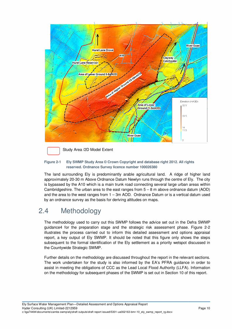
4.2.1 2D Terrain
In InfoWorks CS, the 2D model domain is represented using a triangular “mesh” that covers the
extent of the study area. This mesh is created by sampling LiDAR data, with each triangle being
set at a ground level equal to the average of the ground levels at each of its three corners. The
mesh can be made more detailed by adjusting the size of the triangles comprising the mesh.
Further definition can be added to areas within the mesh via the lowering or raising of levels as
required, for instance to lower roadways or raise areas of land within building footprints to more
accurately model the “channelling” effect of the 2-dimensional features.
Figure 4-1 illustrates an example of the 2d mesh area with more detailed triangles within the
buildings.
Figure 4-1 2D Mesh Representation © Crown Copyright and database right 2012. All rights
reserved. Ordnance Survey licence number 100026380
4.2.2 2D Roughness
A generic roughness of 0.02 has been applied across the whole of the 2D mesh area to
represent the urban areas within the catchment. Roughness polygons have also been used in
the model to represent a higher roughness in rural/open areas of land. A roughness value of
0.045 has been applied in these areas.
Sensitivity testing of the model to differences in 2D roughness was tested and the results are
discussed in Section 6.5.

Ely Surface Water Management Plan—Detailed Assessment and Options Appraisal Report
Hyder Consulting (UK) Limited-2212959 Page 29c:\tga74494\documents\cambs swmp\ely\draft outputs\draft report issued\5301-ua002163-bmr-10_ely_swmp_report_rg.docx
4.2.3 Infiltration
Whilst the direct rainfall model explicitly simulates the channelling and pooling of surface water,
losses to the ground through infiltration are not immediately accounted for. Such a scenario – in
which no infiltration losses are represented – could be assumed to be indicative of a frozen or
highly saturated catchment response. However this is a very conservative assumption and
hence it is desirable to include a measure of infiltration losses in the model to make it more
representative.
As it is not possible to apply areas of differing infiltration across the 2D catchment in the
Infoworks CS software a single infiltration value of 11mm/hr has been applied across the whole
of the 2D study area. This value was calculated based on the differing soil types identified
during hydrological analysis as well as the amount of impermeable surfaces across the study
terrain.
The process for defining a standard infiltration to the 2D was done by
1. Defining the different infiltration rates related to the underlying geology defined in the
Cranfield University’s Soilscape (http://www.landis.org.uk/soilscapes/) website.
2. Calculating the percentage area of permeable area of differing infiltration within the Model
Extent.
3. Defining a single infiltration rate for the whole catchment based on the contributing areas of
differing infiltration within the Model Extent.
This final adjusted value derived from the method above was then deducted from each timestep
of the rainfall hyetograph to represent loss to infiltration.
Whilst ideally the varying infiltration methods across the study catchment would be modelled
such as lower infiltration values for impermeable areas, the method described above makes
best use of both the data provided and the capabilities of the modelling software used.
4.2.4 Representation of Buildings
Buildings have been represented through raising the 2D mesh 5m within the building footprint.
This allows routing of overland flow around buildings. This method forces runoff to flow around
the building, representing a more realistic routing of surface water flows - in particular, in
Cambridgeshire where ground is relatively flat causing shallow and slow velocity flooding.
4.2.5 Representation of Roads
MasterMap base data was used to extract all roads within the study area. This separate road
polygon dataset was stamped onto the underlying DTM with a 100mm drop applied. The
100mm height difference is designed to represent the kerb level. This method allows flow to run
along the lower road network before spilling over the kerb and affecting other areas. This
represents a more realistic routing of surface water flows.
4.2.6 Representation of Foul Flows
The EA National Receptor Database (NRD) was used to calculate the number of residential
properties within the urban area of Ely. An average population per property was obtained from
the National Statistics summary.

Ely Surface Water Management Plan—Detailed Assessment and Options Appraisal Report
Hyder Consulting (UK) Limited-2212959 Page 30c:\tga74494\documents\cambs swmp\ely\draft outputs\draft report issued\5301-ua002163-bmr-10_ely_swmp_report_rg.docx
4.3 Stage 1 - Hydrological Analysis/Bare Earth Modelling
4.3.1 Bare Earth and River Model Construction
The first stage of modelling was to create the Bare Earth and River Model. This model
comprises a 2D model terrain mesh and the local river system of the Great Ouse, plus Clayway
Catchwater, Angle Drove and Hurst Drove. This would improve on the existing Environment
Agency Surface Water flood mapping in that it determined a critical storm duration specific to
the study area and a more refined ground terrain model.
For the purpose of economic assessment the Bare Earth and River Model (and results) is
referred to as the "Do Nothing" option (See Section 7.3 for further detail). The extent of the
model is shown in Figure 4-2 below.
Figure 4-2 Ely Bare Earth and River Model- Extents of Infoworks CS Domain © Crown Copyright and
database right 2012. All rights reserved. Ordnance Survey licence number 100026380
The Ely Infoworks CS domain was established by drawing a polygon around the surface water
catchment. This catchment is generally contained by the A10 to the west and River Ouse to the
East. The IDB area to the west of the A10 was also included within the model as was the Hurst
Lane Reservoir.
For the initial investigation and determination of the critical storm duration, a mesh with a
maximum triangle size of 100 m2 was chosen for the 2D mesh. The resolution of this grid is
Hurst Lane
Reservoir

Ely Surface Water Management Plan—Detailed Assessment and Options Appraisal Report
Hyder Consulting (UK) Limited-2212959 Page 31c:\tga74494\documents\cambs swmp\ely\draft outputs\draft report issued\5301-ua002163-bmr-10_ely_swmp_report_rg.docx
detailed enough to model key flow routes across the study area without having a detrimental
impact on model run times.
Table 4-1 Stage 1 Model Parameters
Model Parameters
Grid Size 100 m2
Time Step 1 second
Storm Duration 30, 60, 120, 240, 480, 960 minutes
Return Periods 0.5% AEP
The results for a 0.5% AEP 60 minute storm are shown in Figure 4-3.
Figure 4-3 Bare Earth and River Model Results for 0.5% AEP storm © Crown
Copyright and database right 2012. All rights reserved. Ordnance Survey
licence number 100026380

Ely Surface Water Management Plan—Detailed Assessment and Options Appraisal Report
Hyder Consulting (UK) Limited-2212959 Page 32c:\tga74494\documents\cambs swmp\ely\draft outputs\draft report issued\5301-ua002163-bmr-10_ely_swmp_report_rg.docx
4.3.2 Design Rainfall
Design rainfall for a variety of return periods and storm durations was generated using Depth
Duration Frequency (DDF) rainfall catchment descriptors, derived from the FEH CD-ROM.
These catchment descriptors are input directly into Infoworks CS, which automatically creates
rainfall hyetographs that are then applied over the catchment area. Figure 4-4 shows a
hyetograph used with the Bare Earth and River Model. The hyetograph defines point rainfall and
duration and is applied over the entire extent of the model.
Figure 4-4 Hyetograph for 0.5% AEP 480 minute duration storm
4.3.3 River Levels
As there a number of Surface Water outfalls in to the River Ouse in Ely, consideration of the
water level in the River Ouse during the rainfall event was important. The Environment Agency
provided modelled flood levels from the 25 year, 50 year 100 year and 200 year flood event.
Following discussions with the client and project team, it was agreed that all rainfall events were
modelled with the 25 year river level on the Ely Ouse without undertaking detailed joint
probability assessments. The levels were obtained from the CFMP Environment Agency Model,
Model Flood Group Reference: EA05225.
This approach was considered to be simpler, realistic and sufficiently conservative given the
large difference between the longer reaction time of the River Ouse catchment compared with
the much shorter critical storm duration of 60mins in Ely. For example, 200 year fluvial event
coinciding with a 200 year rainfall event was considered to be too conservative for the purpose
of SWMP preparation and option development process.
It was also worth noting that the prioritised wetspots areas within Ely are also generally located
on higher ground outside the main influence zone of Ouse water levels but some sensitivity runs
were undertaken to assess the likely impact of higher water levels in the Ouse and are
discussed in Section 6.5.
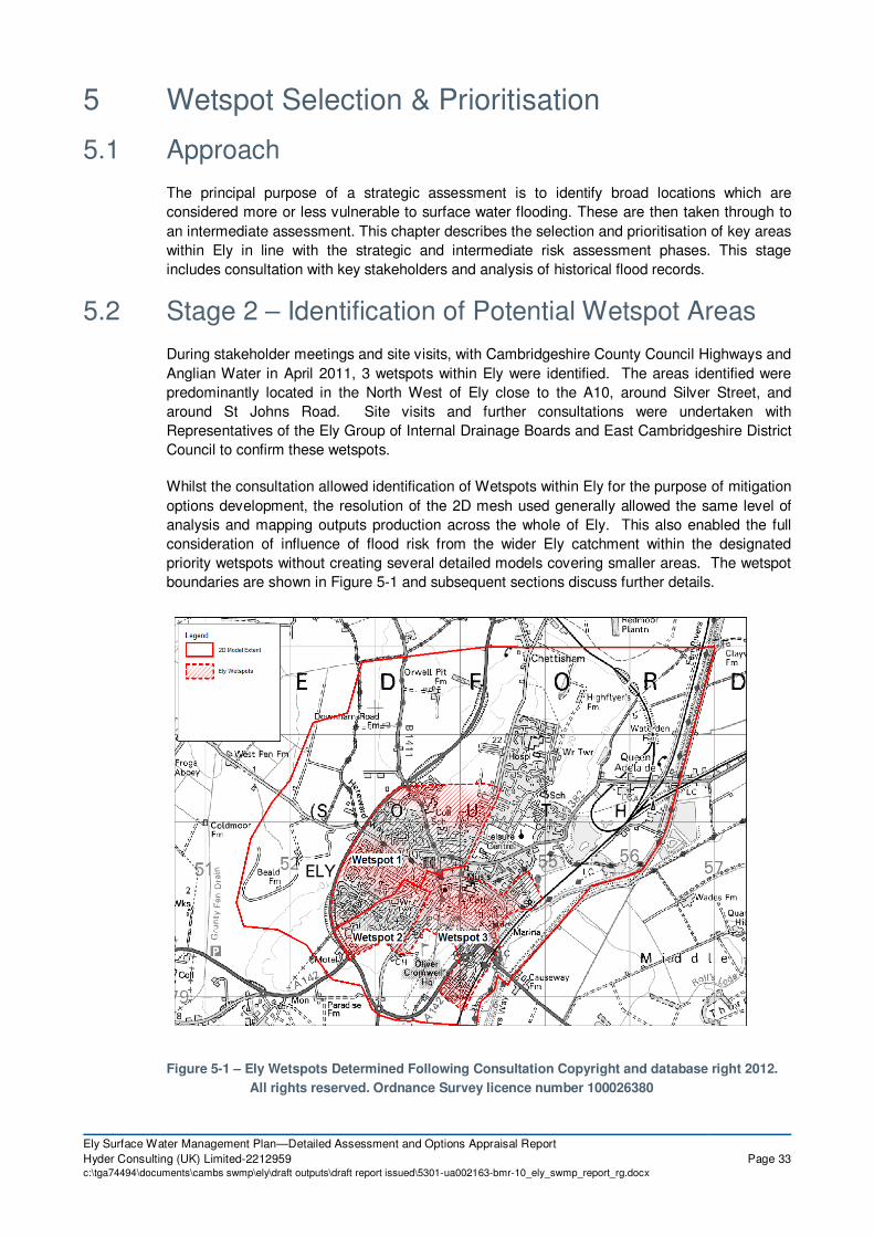
Ely Surface Water Management Plan—Detailed Assessment and Options Appraisal Report
Hyder Consulting (UK) Limited-2212959 Page 33c:\tga74494\documents\cambs swmp\ely\draft outputs\draft report issued\5301-ua002163-bmr-10_ely_swmp_report_rg.docx
5 Wetspot Selection & Prioritisation
5.1 Approach
The principal purpose of a strategic assessment is to identify broad locations which are
considered more or less vulnerable to surface water flooding. These are then taken through to
an intermediate assessment. This chapter describes the selection and prioritisation of key areas
within Ely in line with the strategic and intermediate risk assessment phases. This stage
includes consultation with key stakeholders and analysis of historical flood records.
5.2 Stage 2 – Identification of Potential Wetspot Areas
During stakeholder meetings and site visits, with Cambridgeshire County Council Highways and
Anglian Water in April 2011, 3 wetspots within Ely were identified. The areas identified were
predominantly located in the North West of Ely close to the A10, around Silver Street, and
around St Johns Road. Site visits and further consultations were undertaken with
Representatives of the Ely Group of Internal Drainage Boards and East Cambridgeshire District
Council to confirm these wetspots.
Whilst the consultation allowed identification of Wetspots within Ely for the purpose of mitigation
options development, the resolution of the 2D mesh used generally allowed the same level of
analysis and mapping outputs production across the whole of Ely. This also enabled the full
consideration of influence of flood risk from the wider Ely catchment within the designated
priority wetspots without creating several detailed models covering smaller areas. The wetspot
boundaries are shown in Figure 5-1 and subsequent sections discuss further details.
Figure 5-1 – Ely Wetspots Determined Following Consultation Copyright and database right 2012.
All rights reserved. Ordnance Survey licence number 100026380

Ely Surface Water Management Plan—Detailed Assessment and Options Appraisal Report
Hyder Consulting (UK) Limited-2212959 Page 34c:\tga74494\documents\cambs swmp\ely\draft outputs\draft report issued\5301-ua002163-bmr-10_ely_swmp_report_rg.docx
6 Detailed Assessment
6.1 Stage 3 Detailed Modelled Development
The detailed model was developed to create an integrated terrain, river and sewers.
This chapter describes development of the detailed model, which also includes the underground
drainage network, to enable a detailed assessment across the study area whilst focussing on
the flood mitigation options development within the 3 prioritised wetspots in Ely.
6.1.1 Underground Drainage Network
Anglian Water provided their current sewer network in GIS format, including foul and storm
water sewers, as well as ancillary assets such as outfalls and pumping stations. However, as
described in Section 3.4.3 further consultation and survey were undertaken to fill in the
noticeable data gaps prior to constructing the detailed model.
The Ely storm network utilises existing drains and watercourses within the study catchment. To
the east of and North east of the catchment the storm network discharges in to the River Ouse
and the Clay Way Catchwater. The Clay Way Catchwater outfalls in to the Ouse approximately
2km North of Ely. These areas include the majority of the Commercial areas of Ely.
To the West the storm water network for the predominantly residential area outfalls to the Hurst
Lane Drove, flows from which are controlled by the Hurst Lane Drove Reservoir. The extent of
the sewer network is shown in Figure 6-1.
6.1.2 Coupling of Sewer Model
Once the sewer model was fully populated, it was incorporated into the existing bare earth
model and river model, which also includes parts of local drainage (e.g. Clayway Catchwater
and Hurst Drove systems) that was surveyed by Maltby Surveys to improve the representation
of the open channel within the urban area.
For the purpose of the Economic assessment, the InfoWorks CS model (and results) that
includes the underground drainage network, is referred to as the “Do Minimum” model (See
Section 7.3 for further detail); therefore, this terminology has also been used to describe this
detailed model from here onwards.

Ely Surface Water Management Plan—Detailed Assessment and Options Appraisal Report
Hyder Consulting (UK) Limited-2212959 Page 35c:\tga74494\documents\cambs swmp\ely\draft outputs\draft report issued\5301-ua002163-bmr-10_ely_swmp_report_rg.docx
Figure 6-1 Existing Sewer Network Ely © Crown Copyright and database right 2012. All rights
reserved. Ordnance Survey licence number 100026380
6.2 Model Results Analysis
6.2.1 Wetspot 1 - North West Ely
The results from the 0.5% AEP Do Minimum Model run are shown in Figures 6-2 and Figure 6-3
to show how flows and depths propagate in this area.

Ely Surface Water Management Plan—Detailed Assessment and Options Appraisal Report
Hyder Consulting (UK) Limited-2212959 Page 36c:\tga74494\documents\cambs swmp\ely\draft outputs\draft report issued\5301-ua002163-bmr-10_ely_swmp_report_rg.docx
Legend
Figure 6-2 – Depth of Flooding in North West Ely 0.5% AEP Rainfall Event © Crown Copyright and
database right 2012. All rights reserved. Ordnance Survey licence number 100026380
Legend
Figure 6-3 – Speed of Flooding in North West Ely 0.5% AEP Rainfall Event © Crown Copyright and
database right 2012. All rights reserved. Ordnance Survey licence number 100026380
These figures show how key flow routes enter this area from the east and south east, with some
overland flow along roads, and some across the school fields of the Ely Community College.
There is deep ponding (between 1-2m) of flood water close to the A10 due to the low lying
ground and road embankment.
The EA has advised that the area to the east of the A10 bypass is designed to be an area of
public open space low-land area that can take extreme event flooding as part of an early
strategic drainage scheme.

Ely Surface Water Management Plan—Detailed Assessment and Options Appraisal Report
Hyder Consulting (UK) Limited-2212959 Page 37c:\tga74494\documents\cambs swmp\ely\draft outputs\draft report issued\5301-ua002163-bmr-10_ely_swmp_report_rg.docx
The EA has also advised that in Wetspot 1, the development area to the south of Tennyson
Place where the cover photo was taken also had an early Strategic Drainage Scheme agreed
with the EA and the IDB downstream of the A10 in the late 1990s.
6.2.2 Wetspot 2 – St Johns Road
Figure 6-4 and 6-5 show flows and depth in the area of St John’s Road. Flow along St Johns
Road show two distinct flow paths, one from Hereward Street/Debden Green, towards Ely City
Centre, the second from outside St Johns Community Primary School towards the outskirts of
Ely. Flow towards the City Centre appear to cause flooding above 0.3m in the area of St John’s
Farm and the Junction of St John’s Road and West End.
Legend
Figure 6-4 – Depth of Flooding around St John’s Road, Ely 0.5% AEP Rainfall Event © Crown Copyright and
database right 2012. All rights reserved. Ordnance Survey licence number 100026380

Ely Surface Water Management Plan—Detailed Assessment and Options Appraisal Report
Hyder Consulting (UK) Limited-2212959 Page 38c:\tga74494\documents\cambs swmp\ely\draft outputs\draft report issued\5301-ua002163-bmr-10_ely_swmp_report_rg.docx
Legend
Figure 6-5 – Speed of Flooding around St John’s Road, Ely 0.5% AEP Rainfall Event © Crown Copyright
and database right 2012. All rights reserved. Ordnance Survey licence number 100026380
6.2.3 Wetspot 3 – Silver Street
The area of Silver Street was highlighted during a meeting with representatives of
Cambridgeshire County Council Highways department. It is likely that overland flows in this
wetspot, may contribute to flooding issues around Silver Street. Figures 6-6 and 6-7 show
maximum depth and flow in the area during the 0.5% AEP rainfall event. As with the previous
two wetspots, overland flow routes along roads have an important role in flood risk during the
0.5% AEP rainfall event. There is significant ponding in the grounds of King’s School and also
on the road outside the school as a result of these overland flow paths.

Ely Surface Water Management Plan—Detailed Assessment and Options Appraisal Report
Hyder Consulting (UK) Limited-2212959 Page 39c:\tga74494\documents\cambs swmp\ely\draft outputs\draft report issued\5301-ua002163-bmr-10_ely_swmp_report_rg.docx
Legend
Figure 6-6 – Depth of Flooding around Silver Street, Ely 0.5% AEP Rainfall Event © Crown Copyright and
database right 2012. All rights reserved. Ordnance Survey licence number 100026380
Legend
Figure 6-7 – Speed of Flooding around Silver Street, Ely 0.5% AEP Rainfall Event © Crown Copyright and
database right 2012. All rights reserved. Ordnance Survey licence number 100026380
6.3 Model Verification
Unfortunately, there is currently limited information in the form of historical evidence and no
historical flow monitoring to verify the IWCS model for Ely. The available information is in the
form of anecdotal reports and limited records of historic flooding. Based on this information the
model seems to produce representative outputs for the identified wetspots. However, further
information may be available in relation to existing drainage assets such as privately owned
drains, that was not made available or detailed to the project team at the time the modelling was
undertaken. Therefore, in limited areas, the model may not include facilities that serve to
protect the City and it’s environs that are in situ at present.

Ely Surface Water Management Plan—Detailed Assessment and Options Appraisal Report
Hyder Consulting (UK) Limited-2212959 Page 40c:\tga74494\documents\cambs swmp\ely\draft outputs\draft report issued\5301-ua002163-bmr-10_ely_swmp_report_rg.docx
6.4 Model Assumptions
A number of assumptions have been made within the Ely model. These have been summarised
below.
- Where gaps existed in the AWS foul network dataset an assumed cover level, invert level
and/or pipe diameter was required. These gaps have been filled using automated inference
tools in IWCS.
- Where the AWS Impermeable Area Survey data coverage for Ely did not show which SW or
foul network a property drained to it was assumed that the property was drained by
soakaway.
- The model does not have any representation of the highway gully system. This information
was not readily available and would have been difficult to incorporate into IWCS. Therefore
there may be some surface water risk shown in the model extents which would in fact be
drained away through the gully system to some extent for the lower return period events.
- The model may not adequately represent privately owned assets such as those currently
owned by Church Commissioners or the assets that have been sold off by the Church
Commissioners over the years but the existing drains still are not formally adopted by
Anglian Water. Therefore, the existing drainage system may differently than currently
modelled if these data gaps were filled.
6.5 Model Sensitivity
The results of sensitivity testing of the model are included in Appendix I of the report and
discussed below.
6.5.1 Blockage Analysis
Following consultation with the Project Board on the Draft Report, the Environment Agency
highlighted the Cawdle Main Drain Culvert as a location where blockages may occur due to the
number of service crossings through the culvert. Blockages in the culvert were considered at
three separate locations, at the upstream end of the Culvert (Infoworks Link Location: Angel
Drove Bal Pond Ditch.1), halfway along the culvert underneath the A142 roundabout (Infoworks
Link Location TL54792651.1) and at the downstream end of the culvert just before the outfall in
to the River Ouse (Infoworks Link Location: TL54793751) and are shown in Figure 6-8. Each
blockage was run in a separate model (i.e. the blockages did not coincide) with a 50% blocked
cross-section.
The results showed that a blockage at the location Blockage 3 had the greatest impact on the
flood extents, particularly in the Gas Lane and Station Road area of Ely. All three blockage
scenarios increased the flood risk in the area of the Tesco superstore car park and in the
industrial estate to the south of the Tesco site at Bartholemew’s Walk and St Thomas’s Place.
These results suggest that further investigation into the capacity of this culvert may be
necessary, particularly if the adjoining area and the area downstream of the existing culvert are
targeted for future development.

Ely Surface Water Management Plan—Detailed Assessment and Options Appraisal Report
Hyder Consulting (UK) Limited-2212959 Page 41c:\tga74494\documents\cambs swmp\ely\draft outputs\draft report issued\5301-ua002163-bmr-10_ely_swmp_report_rg.docx
Figure 6-8 Locations of Blockage Locations on Angel Drove Main River Culvert

Ely Surface Water Management Plan—Detailed Assessment and Options Appraisal Report
Hyder Consulting (UK) Limited-2212959 Page 42c:\tga74494\documents\cambs swmp\ely\draft outputs\draft report issued\5301-ua002163-bmr-10_ely_swmp_report_rg.docx
6.5.2 River Levels
The 200 Year Do Minimum Model was run using the 100 Year Modelled Flood Level in the
Ouse. This test was performed to test the sensitivity of the 1D network to the likely ‘outfall
surcharging’ effect of higher water levels in the Ouse.
There was a local impact of the using the 1 in 100 year Flood Level in the Do Minimum model.
However the overall impact on the flood outline (at depths above 0.1m) was a less than 1%
increase in flooded extent.
6.6 Model Outputs
6.6.1 Flood Depth, Velocity and Hazard Maps
Flood depth, velocity and flood hazard mapping has been produced based upon the detailed
model for 1 in 30 (3.33% AEP) and 1 in 200 year (0.5% AEP) return periods using a storm
duration of 60 minutes. The mapping is included within Appendix F and Appendix H includes
additional maps associated with the various options discussed in subsequent sections.
Flood hazard are important factors in the assessment of flood risk and evacuation of the general
public. Three categories of flood hazard have been identified in the DEFRA / Environment
Agency Documents: Flood Risk Assessment Guidance for New Development20
, (DEFRA Report
FD2320) and Flood Risks to People Methodology21
(DEFRA Report FD2321). These are
“Danger for All”, “Danger for Most” and “Danger to Some”. The equation below gives the
relationship between hazard, depth, velocity and debris:
H = (v+0.5) x d +Df Where
H = hazard
v = velocity
d = depth
Df = debris factor
Df = 0.5 for d < 0.25m
Df = 1.0 for d > 0.25m
The mapping presented in the SWMP has been based upon the following thresholds, taken
from DEFRA Report FD2320. However it should be noted that DEFRA Report FD2321 places a
different hazard rating of the transition to Category 3. The FD2320 indicates that the change
occurs at 2.0 whereas the FD2321 report indicates that this happens at 2.5. This has a
significant impact on the interpretation of the results for the SWMP which are discussed below
but it should be noted that the results are presented conservatively as set out below.
Danger to Some Category 1 H > 0.75
Danger to Most Category 2 H > 1.25
Danger to All Category 3 H > 2.00
The colouring of the flood hazard mapping is commensurate with the hazard categorisation
given in Figure 6-9. Areas coloured red are considered dangerous for all; areas in dark yellow
are dangerous to most; light yellow is dangerous to some and blue areas are inundated areas
mainly on the margins of the flood plain which are considered to hold little hazard. The time

Ely Surface Water Management Plan—Detailed Assessment and Options Appraisal Report
Hyder Consulting (UK) Limited-2212959 Page 43c:\tga74494\documents\cambs swmp\ely\draft outputs\draft report issued\5301-ua002163-bmr-10_ely_swmp_report_rg.docx
series graphs show the depth (left axis) and hazard category (right axis) for specific control point
locations as discussed above.
Figure 6-9 Hazard Categorisation
0.05 0.1 0.2 0.3 0.4 0.5 0.6 0.8 1.0 1.5 2.0
0
0.10
0.25
0.50
1.00
1.50
2.00
2.50
3.00
3.50
4.00
4.50
5.00
Danger for Some
Danger for Most
Danger for All
Velo
cit
y o
f F
loo
din
g (
m/s
)
Depth of Flooding (m)

Ely Surface Water Management Plan—Detailed Assessment and Options Appraisal Report
Hyder Consulting (UK) Limited-2212959 Page 44c:\tga74494\documents\cambs swmp\ely\draft outputs\draft report issued\5301-ua002163-bmr-10_ely_swmp_report_rg.docx
7 Engineering Options Identification & Assessment
7.1 Measures Identification
The engineering elements evaluated in this section are based upon employing the most
appropriate techniques for the various sites. The engineering elements proposed within this
section fall into a range of categories as shown in Figure 7-1 and where possible and
economical the use of sustainable drainage systems (SuDS) and surface water reduction
strategies has been promoted over hard infrastructure alternatives such as the upgrading of
existing sewers.

Ely Surface Water Management Plan—Detailed Assessment and Options Appraisal Report
Hyder Consulting (UK) Limited-2212959 Page 45c:\tga74494\documents\cambs swmp\ely\draft outputs\draft report issued\5301-ua002163-bmr-10_ely_swmp_report_rg.docx
Figure 7-1 Surface Water Flood Mitigation Options
The key constraints (see Figure 7-2) associated with the implementation of all of the options are
space and cost.
Figure 7-2 Engineering Options Constraints
Accordingly, the engineering options proposed within the report have been designed to be
accommodated within the urban environment.
It should be noted that the engineering options proposed are potential solutions to current
issues and priorities. During the course of the SWMP time frame, it is possible that these issues
or priorities may change and new constraints and priorities may present themselves. The
Installation of
Source Control
Measures
Upgrading
Sewer
Infrastructure
Installation of
new sewers
Underground
Attenuation
Separation of
Foul & Surface
Up-grading of
Existing Sewers
Wetland / Basin
Attenuation Peripheral
Protection
Retrofitting of
SuDS Systems
Overland Flood
Routing
Installation of
Source Control
Measures
Upgrading
Sewer
Infrastructure
Disruption during
Construction
Capital Cost of
Major
Infrastructure
Timing of
Investment
Space within the
Urban
Environment
Maintenance
Costs
Maintenance of
Green
Infrastructure
Adoption by
Operating
Authorities
Space within the
Urban
Environment

Ely Surface Water Management Plan—Detailed Assessment and Options Appraisal Report
Hyder Consulting (UK) Limited-2212959 Page 46c:\tga74494\documents\cambs swmp\ely\draft outputs\draft report issued\5301-ua002163-bmr-10_ely_swmp_report_rg.docx
options may, therefore, be difficult to implement, and it should be borne in mind that the
engineering works for some options are proposed over a long period.
Across Ely, there are several open spaces which can be utilised for attenuation. Attenuation
has been explored at several locations with the introduction of attenuation basins, wetlands and
ponds and there has been consideration of the use of swales where possible.
After a desk based visual inspection of key flow routes in the study area, open spaces at a
number of schools and recreation areas have been investigated as potential sites for
attenuation structures. It should be noted however that other pressures such as the need to
expand and improve existing school sites may be contrary to using school open spaces in flood
mitigation works. New developments may however offer alternative opportunities for partnership
working, such as utilising green roofs in new school developments.
The street environment and conservation issues in Ely are also significant constraints in the
installation of new drainage infrastructure. Within the wetspots possible techniques including
road side rain gardens and improvements to kerb drainage systems are discussed in detail in
the following sections.
7.2 Ely Engineering Measures and Options
This section of the report considers the engineering elements and the option combinations for
the mitigation of surface water flooding in Ely. The engineering elements and option
combinations considered in this document have been developed from work undertaken during
the course of the project. The majority of engineering elements proposed are targeted at
alleviating flood risk within the 3 wetspots identified during Stage 2 of the intermediate
assessment.
The hydrological and hydraulic, flood risk and economic analyses have allowed the options to
be developed further in order to compare the proposed schemes in terms of cost and technical
suitability.
Cambridgeshire County Council, the Lead Local Flood Authority under the Floods and Water
Management Act, has powers to carry out works for the management of surface water run-off,
ordinary watercourses and groundwater.
Table 7-1 gives a summary description of the engineering elements and Figures 7-3 to 7-6
provides the location of each element. The engineering elements have been combined to form
the option combinations, which have been modelled and analysed, to evaluate their technical
suitability and economic benefits to select a preferred engineering option. The Option
Combinations is included in Section 7-4.
Table 7.1 Ely Engineering Elements
Engineering
Element
Engineering Element
Name Description
Engineering
Element
Alleviating Flood
Risk in Wetspot
ELY-A Highfield Special School – Attenuation Basins
Construction of two attenuation basins at Highfield School.
Wetspot 1
ELY-B City of Ely Community College – Attenuation Basins
Construction of four attenuation basins in the ground of Ely Community College and associated bund.
Wetspot 1
ELY-C St Audrey’s Way – Network Improvement
Construction of a speed hump to hold back water and an additional entrance
Wetspot 1

Ely Surface Water Management Plan—Detailed Assessment and Options Appraisal Report
Hyder Consulting (UK) Limited-2212959 Page 47c:\tga74494\documents\cambs swmp\ely\draft outputs\draft report issued\5301-ua002163-bmr-10_ely_swmp_report_rg.docx
Engineering
Element
Engineering Element
Name Description
Engineering
Element
Alleviating Flood
Risk in Wetspot
and Speed Hump point to the existing sewer network at St Audrey’s Way.
ELY-D A10 Attenuation Basin
Increasing attenuation storage within the existing public open space alongside the eastern side of A10 near Columbine Road.
Wetspot 1
ELY-E Abbots Way – Attenuation Basin
Construction of two interconnected attenuation basins and associated overflow spillway at Abbots Way Recreation Ground.
Wetspot 1
ELY-F Priors Court – Network Improvement
Extension to the existing surface water network in Priors Court to provide an additional entry point to the existing sewer network and an increase in pipe size diameter of 65m of storm network in Priors Court.
Wetspot 1
ELY-G Priors Court – Swale Swale constructed to the east of Priors Court to intercept overland flows.
Wetspot 1
ELY-H Dunstan Street – Rain Gardens & Speed Humps
Construction of two speed humps at the entrance to Priors Court and the new Housing Development off Dunstan Street to hold back water and route overland flow in to two attenuation basins on Dunstan Street.
Wetspot 1
ELY-I
Columbine Road - Beanie Beany Block Curbs Kerbs & Rain Garden
Replacement of existing pavements with Beanie Beany Blocks designed to take intercept overland flow and route into existing drainage network. Construction of Rain Garden.
Wetspot 1
ELY-J West Fen Road – Rain Gardens
Construction of two rain gardens to capture overland flow on West Fen Road.
Wetspot 1
ELY-K Beresford Road – Attenuation Basins
3 Attenuation Basins constructed along Beresford Road to complement the existing drainage ditch.
Wetspot 1
ELY-L Hertford Close – Attenuation Basin
Construction of one attenuation basin on at Hertford Close.
Wetspot 2
ELY-M Longfields – Rain Gardens
Construction of two rain gardens to capture overland flow at Longfields.
Wetspot 2
ELY-N Pilgrim’s Way – Rain Gardens
Construction of two rain gardens to capture overland flow at Pilgrim’s Way.
Wetspot 2
ELY-O Witchford Road – Attenuation Basin
Construction of one attenuation basin on at Witchford Road.
Wetspot 2
ELY-P St Johns Road – Attenuation Basin
Construction of one attenuation basin and associated Bund in the grounds at St John’s Farm, Ely. This option also includes lowering a curb kerb to route flow into the Attenuation Basin.
Wetspot 2
ELY-Q Arundel – Attenuation Basin
Construction of one attenuation basin and associated Bund in the grounds at St John’s Farm, Ely. This option also includes construction of a speed hump and lowering a curb kerb to route flow into the Attenuation Basin.
Wetspot 1

Ely Surface Water Management Plan—Detailed Assessment and Options Appraisal Report
Hyder Consulting (UK) Limited-2212959 Page 48c:\tga74494\documents\cambs swmp\ely\draft outputs\draft report issued\5301-ua002163-bmr-10_ely_swmp_report_rg.docx
Engineering
Element
Engineering Element
Name Description
Engineering
Element
Alleviating Flood
Risk in Wetspot
ELY-R Ely Community College – Channel Widening
Channel widening of a drainage ditch close to Ely Community College, this option also included construction of a speed hump to route flow into the widened ditch.
Wetspot 1
ELY-S King’s School – Attenuation Basins
A series of 3 attenuation ponds in the grounds of King’s School (this option extends on existing pond in the King’s School grounds). The ponds are linked by 2 pipes totalling.
Wetspot 3
ELY-T Ely Rain Gardens (177 Rain Gardens)
Utilisation of existing green areas alongside roads that were shown to be situated in key flow routes in the Ely Bare Earth (Do Nothing) model.
All
ELY-U Ely Community College – Channel Widening
ELY-R Optimised - Channel widening of a drainage ditch close to Ely Community College excluding the construction of a speed hump.
Wetspot 1
ELY-V Highfield Special School – Attenuation Basins
ELY-A Optimised – Depth of 1x Attenuation structure dropped by a further 0.1m
Wetspot 1
ELY-W City of Ely Community College – Attenuation Basins
ELY-B Optimised – Attenuation basin depth increased by 0.1m
Wetspot 1
ELY-X Dunstan Street – Rain Gardens & Speed Humps
ELY-H Optimised – 1x Road Attenuation structure dropped by a further 0.5m.
Wetspot 1
ELY-Y
Columbine Road - Beanie Beany Block Curbs Kerbs & Rain Garden
ELY-I – Optimised – Rain garden depth dropped by a further 0.25m
Wetspot 1
ELY-Z Beresford Road – Attenuation Basins
ELY-K Optimised – 2x Attenuation basin depth increased by 0.2m in total.
Wetspot 1
ELY-AA Hertford Close – Attenuation Basin
ELY-L Optimised – Attenuation basin depth increased by 0.2m.
Wetspot 2
ELY-AB Longfields – Rain Gardens
ELY-M Optimised – Depth dropped on 2x Rain garden by a further 0.15m
Wetspot 2
ELY-AC Pilgrim’s Way – Rain Gardens
ELY-N Optimised – Depth dropped on 2x Rain garden by a further 0.15m
Wetspot 2
ELY-AD St Johns Road – Attenuation Basin
ELY-P Optimised – Depth of attenuation basin dropped by further 0.1m
Wetspot 2
ELY-AE Arundel – Attenuation Basin
ELY-Q Optimised – Bund height increase by 0.2m.
Wetspot 1
ELY-AF King’s School – Attenuation Basins
ELY-S Optimised - Depth of 2x attenuation ponds dropped by a further 0.6m in total.
Wetspot 3
Figure 7-3 to 7-5 shows the Engineering Options Combinations modelled to reduce surface
water flood risk in the 3 Ely Wetspots.
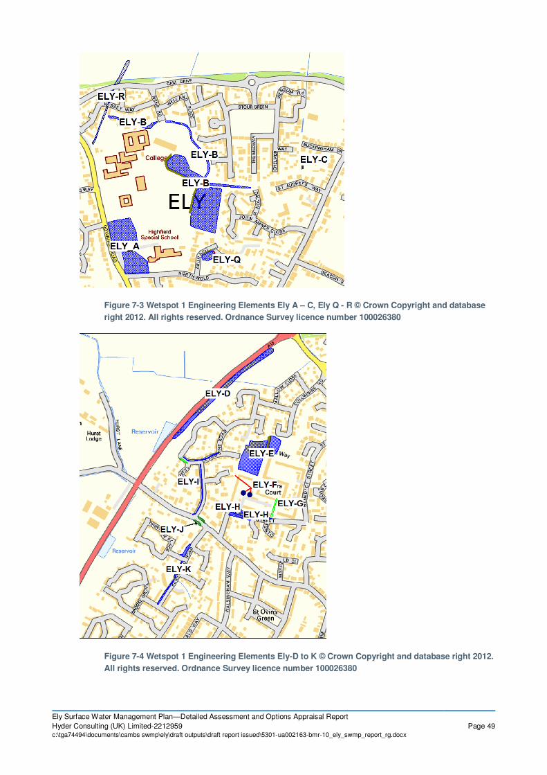
Ely Surface Water Management Plan—Detailed Assessment and Options Appraisal Report
Hyder Consulting (UK) Limited-2212959 Page 49c:\tga74494\documents\cambs swmp\ely\draft outputs\draft report issued\5301-ua002163-bmr-10_ely_swmp_report_rg.docx
Figure 7-3 Wetspot 1 Engineering Elements Ely A – C, Ely Q - R © Crown Copyright and database
right 2012. All rights reserved. Ordnance Survey licence number 100026380
Figure 7-4 Wetspot 1 Engineering Elements Ely-D to K © Crown Copyright and database right 2012.
All rights reserved. Ordnance Survey licence number 100026380

Ely Surface Water Management Plan—Detailed Assessment and Options Appraisal Report
Hyder Consulting (UK) Limited-2212959 Page 50c:\tga74494\documents\cambs swmp\ely\draft outputs\draft report issued\5301-ua002163-bmr-10_ely_swmp_report_rg.docx
Figure 7-5 Wetspot 2 Engineering Elements Ely-L to P © Crown Copyright and database right 2012.
All rights reserved. Ordnance Survey licence number 100026380
Figure 7-6 Wetspot 3 Engineering Elements Ely S © Crown Copyright and database right 2012. All
rights reserved. Ordnance Survey licence number 100026380

Ely Surface Water Management Plan—Detailed Assessment and Options Appraisal Report
Hyder Consulting (UK) Limited-2212959 Page 51c:\tga74494\documents\cambs swmp\ely\draft outputs\draft report issued\5301-ua002163-bmr-10_ely_swmp_report_rg.docx
7.3 Ely Engineering Option Combinations
In order to address flooding within Ely and for the purposes of the SWMP, combinations of
options have been developed. These have been tested for their effectiveness of reducing
flooding in each wetspot.
The engineering elements described in Section 7.2 have been combined into Option
Combinations which have been evaluated for the purposes of the SWMP. These combinations
reflect the predicted flooding mechanisms described above with the objective of determining
their technical suitability and whether there is an economic case for the mitigation of surface
water flooding in all 3 wetspots.
The Option Combination Elements were combined into ‘Do Something’, which includes ‘Do
Minimum’ and other Option Combinations C1, to C3, as shown in Table 7-2 overleaf.
All Option Combinations are listed below:-
� Do Nothing – The "Do Nothing" option assumes that no maintenance, clearance or other
intervention is made to interfere with the natural fluvial processes or sewer network (See
Section 4.1.3). The evaluation of the "Do Nothing" option is a technical requirement
required by the Treasury in order to enable comparisons to be made between the "Do
Minimum" and "Do Something" options.
� Do Minimum– Maintenance of the existing storm sewer, ordinary watercourse and
highway drainage including, gully cleaning, jetting, removal of debris / vegetation;
treeworks and periodic removal of deposition and sediments.
� Option Combination C1 – This comprises all the possible engineering options included
to intercept overland flows and based on the results of the Do Nothing and Do Minimum
runs.
� Option Combination C2 – This option assess the benefit of utilising existing small road
side green areas for conversion in to rain gardens across Ely.
� Option Combination C3 – This option represents an optimised version of Option
Combination C1. Optimisation was achieved via utilising and improving the most cost-
effective engineering elements and removing the least cost-effective engineering
elements from the Option Combination C1.
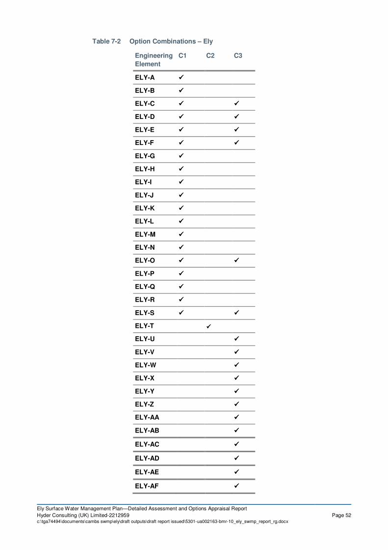
Ely Surface Water Management Plan—Detailed Assessment and Options Appraisal Report
Hyder Consulting (UK) Limited-2212959 Page 52c:\tga74494\documents\cambs swmp\ely\draft outputs\draft report issued\5301-ua002163-bmr-10_ely_swmp_report_rg.docx
Table 7-2 Option Combinations – Ely
Engineering
Element
C1 C2 C3
ELY-A ����
ELY-B ����
ELY-C ���� ����
ELY-D ���� ����
ELY-E ���� ����
ELY-F ���� ����
ELY-G ����
ELY-H ����
ELY-I ����
ELY-J ����
ELY-K ����
ELY-L ����
ELY-M ����
ELY-N ����
ELY-O ���� ����
ELY-P ����
ELY-Q ����
ELY-R ����
ELY-S ���� ����
ELY-T ����
ELY-U ����
ELY-V ����
ELY-W ����
ELY-X ����
ELY-Y ����
ELY-Z ����
ELY-AA ����
ELY-AB ����
ELY-AC ����
ELY-AD ����
ELY-AE ����
ELY-AF ����

Ely Surface Water Management Plan—Detailed Assessment and Options Appraisal Report
Hyder Consulting (UK) Limited-2212959 Page 53c:\tga74494\documents\cambs swmp\ely\draft outputs\draft report issued\5301-ua002163-bmr-10_ely_swmp_report_rg.docx
8 Economic Appraisal
8.1 Introduction
The engineering elements described in Section 7 have been combined to form flood risk
mitigation option combinations shown in Table 7-2. These option combinations have been
assessed in relation to whole life costs, flood damages and residual damages in accordance
with the methodology contained in the following documents.
� Flood and Coastal Erosion Project Appraisal Guidance (FCERM-AG Manual)22
.
� The Benefits of Flood and Coastal Risk Management: A Handbook of Assessment
Techniques23
The latter document is also known as the Multi-Coloured Handbook, and is based on the Multi-
Coloured Manual (MCM) originally published in 2005. The evaluation of the residual risk of
flooding has been discussed in the relevant sections associated with the option combinations.
The residual flood risk damages relating to the “Do Something” options have been discounted
annually to enable a direct comparison with other options. A variable discount rate, beginning at
3.5%, has been adopted for the cost benefit analysis, in line with HM Treasury guidance.
A value engineering exercise was undertaken to evaluate the Option Combinations which
indicated that a significant factor in the costs of works was associated with the excavation and
disposal to landfill of materials for the formation of attenuation basins and other flood mitigation
infrastructure. Accordingly the economic analysis assumes that all excavated materials will be
re-used on site to avoid the cost of disposal of the material. This could include the formation of
embankments and other landscaping features. This avoids costs associated with disposal
including land fill tax. It also promotes the sustainable credentials of the project by reducing the
carbon footprint associated with the transportation of materials for disposal.
Whilst an optimism bias of 60% has been applied to all of the cost estimates (as per the current
guidance applicable for a strategy of this nature) there are a number of economic risks or
uncertainties associated with the development of the cost estimates. The principal economic
risks associated with the preferred option are:
� Cost associated with dealing with utilities which have not been itemised in the cost
estimates
� The cost of land negotiations and compensation for disruption
� Agreement with local residents to implement/contribute towards the costs of property
level measures
It is therefore considered that significant effort should be placed into obtaining agreements with
landowners and stakeholders to undertake the proposed works. In order to mitigate this risk it is
recommended that CCC and the Cambridgeshire Flood Risk Management Partnership enter into
discussion with all landowners and stakeholders at the earliest opportunity during the design
process to ensure their collaboration. A review of the service/utilities locations during pre-
feasibility into the scheme would help to identify their impact on scheme costs.
8.1.1 Methodology – Damages Assessment
The assessment of cost associated with flood damage of properties in Ely has been assessed
using the DEFRA and Environment Agency approved approach outlined in the Multi- Coloured
Handbook. This method for assessing damages uses depth/damage curves based on property

Ely Surface Water Management Plan—Detailed Assessment and Options Appraisal Report
Hyder Consulting (UK) Limited-2212959 Page 54c:\tga74494\documents\cambs swmp\ely\draft outputs\draft report issued\5301-ua002163-bmr-10_ely_swmp_report_rg.docx
type, age and social class of the dwellings occupants, in order to evaluate the overall damage
avoided in a flood risk area.
For the preferred option, flood depth results for each return period were extracted for all
properties within the modelled region. With respect to the flood depth, damages result from the
physical contact of flood water with damageable property.
National Property Dataset (NPD) has been used to form the basis of the damages assessment.
In order to calculate flood damages at a property level, the following information is required for
each property includes:
� A property ‘type’
� A floor area (for non-residential property)
� A property threshold
The NPD dataset used for this study does not provide the property threshold level therefore
LiDAR inclusive of an additional 0.1m was used to determine the threshold level of each
property. By applying flood depths to each property (adjusted to account for threshold), the flood
damages were calculated using the depth-damage curves for each individual event. Annual
Average Damages (AAD) were then calculated for each scenario: ‘Do Nothing’, ‘Do Minimum’
and ‘Do Something’ preferred option.
Depending on the size or severity of each individual flood event of a given annual probability,
each flood event will cause a different amount of flood damage. The Average Annual Damage
(AAD) is the average damage per year in monetary terms that would occur at each specific
address point, within the modelled domain, from flooding over a 100 year period, assuming that
present-day conditions (in terms of frequency of extreme rainfall) are maintained.
In many years there may be no flood damage, in some years there will be minor damage
(caused by small, relatively frequent floods) and, in a few years, there may be major flood
damage (caused by large, rare flood events). Estimation of the AAD provides a basis for
comparing the effectiveness of different flood alleviation and management measures (i.e.
through measuring the reduction in AAD).
The methodology for assessing the benefits of flood alleviation combines:
� An assessment of risk, in terms of the probability or likelihood of future floods to be
averted; and
� A vulnerability assessment in terms of the damage that would be caused by those floods
and therefore the economic saving to be gained by their reduction.
Through assessment of the associated damage values and the benefits incurred through
Engineering Options, proposed schemes are compared against each other using their benefit-
cost ratio (BCR).
To identify a preferred option, a comparison was undertaken between the consequences of ‘Do
Something’ Engineering Options against the baseline option, ‘Do Minimum’. The SWMP Project
Board requested that the ‘Do Minimum’ scenario was used as the baseline for the economic
analysis as it assumes a continuance of existing maintenance of the sewer and local drainage
network. The Board felt that the ‘Do Nothing’ scenario was unrealistic as the water companies
have a statutory right to maintain public sewers.
The cost of each option combination and the relative damages incurred are combined to create
a benefit cost ratio. This ratio is used to assess the viability of the preferred option and also the
levels of effectiveness for how capital can be spent to protect against the effects of flooding. The

Ely Surface Water Management Plan—Detailed Assessment and Options Appraisal Report
Hyder Consulting (UK) Limited-2212959 Page 55c:\tga74494\documents\cambs swmp\ely\draft outputs\draft report issued\5301-ua002163-bmr-10_ely_swmp_report_rg.docx
BCR is the ratio of benefits produced through introduction of flood alleviation options, expressed
in monetary terms, relative to its cost, identifying the greatest ‘value for money’.
The Multi-Coloured HandbookError! Bookmark not defined.23
states that;
‘Projects are only viable if the benefits exceed the costs (i.e. the ratio of benefits to costs is
greater than 1.0). Where benefits marginally exceed costs, there is often high uncertainty as to
whether an option is justified, because only a small change or error in either the benefits or
costs would tilt the balance the other way. So when comparing a ‘Do Something’ option to the
baseline option, confidence is needed that a ‘Do Something’ option is clearly preferable.’
In this regard, the decision process explored whether the best value for money is provided while
achieving the most appropriate standard of risk management defence. This is undertaken by
assessing the incremental benefit-cost ratio of each economically viable option.
Key Parameters
For reference, key parameters which have guided the economic assessment process, in line
with FCERM-AG/MCM techniques, are repeated below:
• Property Values: Properties were assigned a market value in order that present value
damages (PVd) were ‘capped’ if they exceeded a property’s market value over the
appraisal period. These ‘capping values’ were derived according to Environment
Agency best practice. Distributional impacts (DI) were considered, in order to remove
social class bias from the property value estimates. A DI factor was calculated using
Approximate Social Grade (UV50) data for the relevant Cambridgeshire authority,
available from neighbourhood.statistics.gov.uk.
• Emergency services costs: These were incorporated in the assessment by adding
5.6% to all calculated property damages. This is as stated in the Multi-coloured
Handbook and is based on data from the 2007 floods, a revision downwards from the
previous values of approximately 10%, reflecting economies of scale of providing
emergency services in urban areas during flood events.
• Temporary accommodation costs: These were incorporated in the assessment by
allowing for an average rental cost, post-flood, of £5.7k per property flooded,
determined in an Environment Agency review of the summer 2007 floods.
Section 8.2 highlights the key assumptions made in damage assessment (including limitations
and further recommendations) and specific attention should be given to these prior to using the
currently published SWMP economic assessment outputs. Section 8.3 also summarises key
exclusions from the damage assessment.
8.1.2 Economic Risks
The principal economic risks are associated with the construction of all Engineering Options
are:-
� Cost of possible diversion of utilities;
� Cost of land negotiations
� Compensation for disruption
� Buildability
� Ecolological and other environmental risks and associated costs

Ely Surface Water Management Plan—Detailed Assessment and Options Appraisal Report
Hyder Consulting (UK) Limited-2212959 Page 56c:\tga74494\documents\cambs swmp\ely\draft outputs\draft report issued\5301-ua002163-bmr-10_ely_swmp_report_rg.docx
� Sensitivity of flood damage assessment and model limitations (e.g. actual property
threshold levels and flood levels – see section 8.2 and 6.3)
It is recommended that as part of Business Case Justification/ Project Appraisal Reporting
process and the subsequent detailed design of the flood mitigation proposals the above risks are
addressed accordingly. The project lead should approach utility companies to obtain agreements
for the relocation of services as necessary. In addition the project lead should engage with all
landowners and stakeholders at the earliest opportunity during the design process to ensure
their collaboration.
8.1.3 Cost Estimates
Each of the proposed Option elements has been costed in accordance with information on
maintenance expenditure obtained from Cambridge City Council and Cambridgeshire County
Council and SPON’s Civil Engineering and Highways Price Book24
.

Ely Surface Water Management Plan—Detailed Assessment and Options Appraisal Report
Hyder Consulting (UK) Limited-2212959 Page 57c:\tga74494\documents\cambs swmp\ely\draft outputs\draft report issued\5301-ua002163-bmr-10_ely_swmp_report_rg.docx
8.1.4 Benefit Cost Analysis
Table 8-1 summarises the Present Value Damages associated with the ‘Do Nothing’, ‘Do
Minimum’, Option C1, C2, and C3 for each of the wetspots.
North-West Ely –
Wetspot 1
St Johns Road –
Wetspot 2
Silver Street –
Wetspot 3
Option
Combination
Present Value Damages (£)
Do Nothing 32,546,000 6,655,000 32,628,000
Do Minimum 26,690,000 5,542,000 31,840,000
Option C1 22,802,000 5,072,000 31,563,000
Option C2 22,762,000 5,069,000 31,264,000
Option C3 22,113,000 5,044,000 31,346,000
Table 8-1 Flood and Residual Flood Damages
Based upon the assessment of damages and the cost estimates given for each option
combination, the present value damages have been combined with the whole life cost estimates
within Table 8-2 to 8-5. These tables summarises the costs, benefits and residual damages
associated with each option.
Standard routine costs for maintenance of the existing drainage assets have not been included
in the appraisal since they are not funded via capital funding scheme grants and would be
commensurate for all options.

Ely Surface Water Management Plan—Detailed Assessment and Options Appraisal Report
Hyder Consulting (UK) Limited-2212959 Page 58c:\tga74494\documents\cambs swmp\ely\draft outputs\draft report issued\5301-ua002163-bmr-10_ely_swmp_report_rg.docx
A B C D E
Costs and benefits £
Do
Nothing
Do
Minimum
Option
C1
Option
C2
Option
C3
1 PV costs from
estimate 964,543 224,500* 931,772
2 Optimism bias
adjustment
(C1*0.6) 578,725 134,700* 559,063
3 Total PV Costs
from appraisal
(PVc)
(C1+C2) 1,543,268 359,200* 1,490,835
4 PV damage (PVd *) 32,546,000 26,690,000 22,802,000 22,762,000* 22,144,000
5 PV damage
avoided
(B4-C4) 3,888,000 3,928,000* 4,546,000
6 Total PV benefits
(PVb)
(=C5) 3,888,000 3,928,000* 4,546,000
7 Net Present Value
(NPV)
(C6-C3) 2,344,731 3,568,800* 3,055,165
8 Average benefit cost
ratio
(C6/C3) 2.52 2-10* 3.05
*See Section 8.4 for further discussion on Option C2 Cost Benefit Ratio
Table 8-2 Summary of Costs and Damages for North West Ely – Wetspot 1
Based on the benefit cost ratios calculated above Option C3, the optimised engineering options
solutions is shown to be the most economically viable solution for the North-West Ely wetspot.
This highlights the importance of optimising engineering options, even at the strategic stage of
the assessment. However, the model results for Option C3 has shown a slight increase in water
levels (up to 30mm - compared to Do Minimum results) in Kent Close area where it appears to
have suffered from previous flooding based on the recent feedback received during the
finalisation of this report. The slight increase in water levels is likely to be due to the proposed
two speed humps at the entrance to Priors Court as part of Engineering Element ELY-X. Based
on the examination of model results for the Option C1, this impact can be successfully mitigated
by reintroducing the Engineering Element ELY-G (Priors Court – Swale) to the preferred option.
Alternatively, the speed humps may be simply removed but this may increase water levels again
in Priors Court area slightly reducing the effectiveness of the proposed measure ELY-X.

Ely Surface Water Management Plan—Detailed Assessment and Options Appraisal Report
Hyder Consulting (UK) Limited-2212959 Page 59c:\tga74494\documents\cambs swmp\ely\draft outputs\draft report issued\5301-ua002163-bmr-10_ely_swmp_report_rg.docx
A B C D E
Costs and benefits £
Do
Nothing
Do
Minimum
Option
C1
Option
C2
Option
C3
1 PV costs from
estimate 129,298 67,350* 58,345
2 Optimism bias
adjustment
(C1*0.6) 77,578 40,410* 35,007
3 Total PV Costs
from appraisal
(PVc)
(C1+C2) 206,876 107,760* 93,352
4 PV damage (PVd *) 6,655,000 5,542,000 5,072,000 5,069,000* 5,044,000
5 PV damage
avoided
(B4-C4) 470,000 473,000* 498,000
6 Total PV benefits
(PVb)
(=C5) 470,000 473,000* 498,000
7 Net Present Value
(NPV)
(C6-C3) 263,123 365,240* 404,647
8 Average benefit cost
ratio
(C6/C3) 2.27 2-10* 5.33
*See Section 8.4 for further discussion on Option C2 Cost Benefit Ratio
Table 8-3 Summary of Costs and Damages for St Johns Road
Based on the benefit cost ratios calculated above Option C3, the optimised engineering options
solutions is shown to be the most economically viable solution for the St Johns Road wetspot.
This highlights the importance of optimising engineering options, even at the strategic stage of
the assessment.
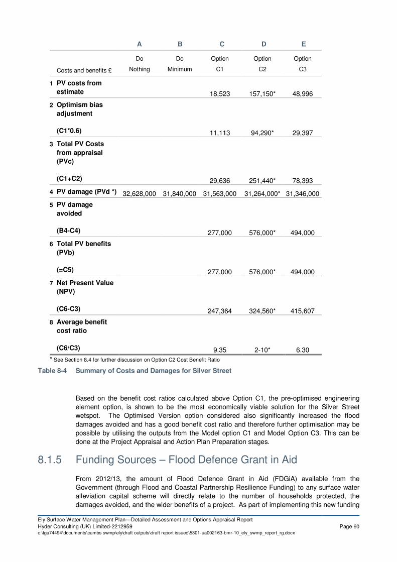
Ely Surface Water Management Plan—Detailed Assessment and Options Appraisal Report
Hyder Consulting (UK) Limited-2212959 Page 60c:\tga74494\documents\cambs swmp\ely\draft outputs\draft report issued\5301-ua002163-bmr-10_ely_swmp_report_rg.docx
A B C D E
Costs and benefits £
Do
Nothing
Do
Minimum
Option
C1
Option
C2
Option
C3
1 PV costs from
estimate 18,523 157,150* 48,996
2 Optimism bias
adjustment
(C1*0.6) 11,113 94,290* 29,397
3 Total PV Costs
from appraisal
(PVc)
(C1+C2) 29,636 251,440* 78,393
4 PV damage (PVd *) 32,628,000 31,840,000 31,563,000 31,264,000* 31,346,000
5 PV damage
avoided
(B4-C4) 277,000 576,000* 494,000
6 Total PV benefits
(PVb)
(=C5) 277,000 576,000* 494,000
7 Net Present Value
(NPV)
(C6-C3) 247,364 324,560* 415,607
8 Average benefit
cost ratio
(C6/C3) 9.35 2-10* 6.30
* See Section 8.4 for further discussion on Option C2 Cost Benefit Ratio
Table 8-4 Summary of Costs and Damages for Silver Street
Based on the benefit cost ratios calculated above Option C1, the pre-optimised engineering
element option, is shown to be the most economically viable solution for the Silver Street
wetspot. The Optimised Version option considered also significantly increased the flood
damages avoided and has a good benefit cost ratio and therefore further optimisation may be
possible by utilising the outputs from the Model option C1 and Model Option C3. This can be
done at the Project Appraisal and Action Plan Preparation stages.
8.1.5 Funding Sources – Flood Defence Grant in Aid
From 2012/13, the amount of Flood Defence Grant in Aid (FDGiA) available from the
Government (through Flood and Coastal Partnership Resilience Funding) to any surface water
alleviation capital scheme will directly relate to the number of households protected, the
damages avoided, and the wider benefits of a project. As part of implementing this new funding

Ely Surface Water Management Plan—Detailed Assessment and Options Appraisal Report
Hyder Consulting (UK) Limited-2212959 Page 61c:\tga74494\documents\cambs swmp\ely\draft outputs\draft report issued\5301-ua002163-bmr-10_ely_swmp_report_rg.docx
policy, revised Outcome Measure definitions have been agreed to replace the previous suite of
measures that expired in March 2011. The Outcome Measures are detailed in the list below:
• Outcome Measure 1 – Economic Benefits
• Outcome Measure 2 – Households at risk
• Outcome Measure 2b – Households at very significant and significant risk
• Outcome Measure 2c – Deprived households at very significant and significant risk
• Outcome Measure 3 – Households at risk from coastal erosion
• Outcome Measure 3b – Households at risk from coastal erosion in 20 years
• Outcome Measure 3c – Deprived households at risk from coastal erosion in 20 years
• Outcome Measure 4a – Hectares of water dependent habitat created or improved
• Outcome Measure 4b – Hectares of intertidal habitat created
• Outcome Measure 4c – Kilometres of rivers protected under the EU Habitats/Birds
The key data from the Engineering Options that will be required for completion of the Flood
Defence Grant in Aid Calculator for each individual wetspot will be available to CCC through
SWMP outputs.
8.2 Damages Assessments - Assumptions
Assumption 1 – Property thresholds across the study catchment are 0.1m and no
flooding of properties will occur below this 0.1m threshold. Due to the number of
properties across the study area it would not be possible to estimate threshold levels for each
property. As such an assumption of a threshold level of 0.1m at all properties has been made.
Furthermore it has been assumed that no damage occurs to property when the flood level at the
property is between 0 - 0.1m (below the threshold). It is possible that flood water can still enter
properties below the threshold level via airbricks but this is not considered in this damages
assessment.
The 0.1m property threshold level is a standard assumption that a property will have a small
step on entry however this threshold may result in an overestimation in the number of properties
at risk and the level of damages. Sensitivity analysis has been undertaken to assess the impact
of raising the property threshold to 0.2m and 0.3m respectively in the economic analysis.
By increasing the threshold level to 0.2m in the economic analysis there was a 79% average
reduction in the number of flooded properties across the 3 wetspots. With a threshold level of
0.3m set there was a 90% average reduction in the number of flooded properties across the
wetspots. Wetspot 2 showed the most significant difference in flooded properties with 93% of
the properties within the wetspot being eliminated from analysis when the threshold level was
increased to 0.3m.
This sensitivity testing has highlighted the importance of establishing accurate property
threshold levels to ensure that the most appropriate and effective options can be identified.
Therefore, doorstep surveys of sample of impacted properties are strongly recommended so
that a representative assumption can be taken about property thresholds as part of further
detailed Business Case Justification/ Project Appraisal Reporting for each wetspot.
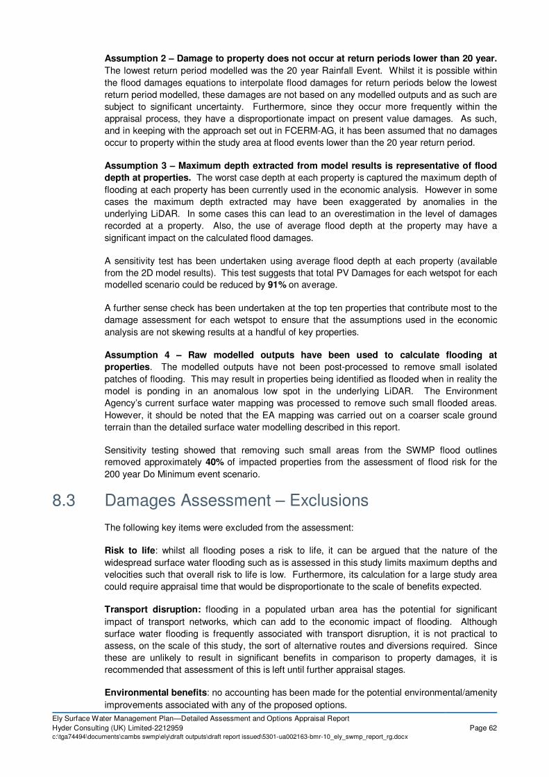
Ely Surface Water Management Plan—Detailed Assessment and Options Appraisal Report
Hyder Consulting (UK) Limited-2212959 Page 62c:\tga74494\documents\cambs swmp\ely\draft outputs\draft report issued\5301-ua002163-bmr-10_ely_swmp_report_rg.docx
Assumption 2 – Damage to property does not occur at return periods lower than 20 year.
The lowest return period modelled was the 20 year Rainfall Event. Whilst it is possible within
the flood damages equations to interpolate flood damages for return periods below the lowest
return period modelled, these damages are not based on any modelled outputs and as such are
subject to significant uncertainty. Furthermore, since they occur more frequently within the
appraisal process, they have a disproportionate impact on present value damages. As such,
and in keeping with the approach set out in FCERM-AG, it has been assumed that no damages
occur to property within the study area at flood events lower than the 20 year return period.
Assumption 3 – Maximum depth extracted from model results is representative of flood
depth at properties. The worst case depth at each property is captured the maximum depth of
flooding at each property has been currently used in the economic analysis. However in some
cases the maximum depth extracted may have been exaggerated by anomalies in the
underlying LiDAR. In some cases this can lead to an overestimation in the level of damages
recorded at a property. Also, the use of average flood depth at the property may have a
significant impact on the calculated flood damages.
A sensitivity test has been undertaken using average flood depth at each property (available
from the 2D model results). This test suggests that total PV Damages for each wetspot for each
modelled scenario could be reduced by 91% on average.
A further sense check has been undertaken at the top ten properties that contribute most to the
damage assessment for each wetspot to ensure that the assumptions used in the economic
analysis are not skewing results at a handful of key properties.
Assumption 4 – Raw modelled outputs have been used to calculate flooding at
properties. The modelled outputs have not been post-processed to remove small isolated
patches of flooding. This may result in properties being identified as flooded when in reality the
model is ponding in an anomalous low spot in the underlying LiDAR. The Environment
Agency’s current surface water mapping was processed to remove such small flooded areas.
However, it should be noted that the EA mapping was carried out on a coarser scale ground
terrain than the detailed surface water modelling described in this report.
Sensitivity testing showed that removing such small areas from the SWMP flood outlines
removed approximately 40% of impacted properties from the assessment of flood risk for the
200 year Do Minimum event scenario.
8.3 Damages Assessment – Exclusions
The following key items were excluded from the assessment:
Risk to life: whilst all flooding poses a risk to life, it can be argued that the nature of the
widespread surface water flooding such as is assessed in this study limits maximum depths and
velocities such that overall risk to life is low. Furthermore, its calculation for a large study area
could require appraisal time that would be disproportionate to the scale of benefits expected.
Transport disruption: flooding in a populated urban area has the potential for significant
impact of transport networks, which can add to the economic impact of flooding. Although
surface water flooding is frequently associated with transport disruption, it is not practical to
assess, on the scale of this study, the sort of alternative routes and diversions required. Since
these are unlikely to result in significant benefits in comparison to property damages, it is
recommended that assessment of this is left until further appraisal stages.
Environmental benefits: no accounting has been made for the potential environmental/amenity
improvements associated with any of the proposed options.

Ely Surface Water Management Plan—Detailed Assessment and Options Appraisal Report
Hyder Consulting (UK) Limited-2212959 Page 63c:\tga74494\documents\cambs swmp\ely\draft outputs\draft report issued\5301-ua002163-bmr-10_ely_swmp_report_rg.docx
Health and social benefits: these perceived benefits attributable to undertaking flood
prevention works and increasing health and well-being were not included. This view was taken
because it was considered unlikely that the local population would necessarily perceive any
benefit from a form of flooding which does not result in a noticeable flood pathway or a great
depth of flooding (as would be the case for river or sea flooding).
8.4 Option C2 – Rain Gardens
Option C2 focused on identifying small land parcels that could be potentially converted into
roadside rain gardens across the Ely study area through a high level assessment. These rain
gardens are currently located both within and outside the three wetspot areas. The total cost of
the rain gardens was estimated to be £2.5m. Where rain gardens fall outside wetspot
boundaries it was not possible to fully separate out which rain garden was actually providing
benefit to which wetspot. Therefore, currently there is some uncertainty in the benefits and cost
estimates given in tables 8-2 to 8-4 under each wetspot with this option. As such, the cost-
benefit ratio is not a definitive value but based on the upper and lower values of cost-benefit
ratios calculated for this option across the three wetspots.
It should be noted that this model option was run mainly to assess how small parcels of land
could be used to provide flood mitigation, should acquisition of land for larger flood relief
schemes prove difficult or prohibitive. The results indicate that further consideration to these rain
gardens may be given during the detailed design stage as part of the SWMP Action Plan for
these wetspots if necessary.

Ely Surface Water Management Plan—Detailed Assessment and Options Appraisal Report
Hyder Consulting (UK) Limited-2212959 Page 64c:\tga74494\documents\cambs swmp\ely\draft outputs\draft report issued\5301-ua002163-bmr-10_ely_swmp_report_rg.docx
9 Summary
In order to address the specific issues relating to the Ely SWMP, a three stage modelling
strategy was developed and implemented:
� Stage 1 - Hydrological analysis and development of broad scale, bare earth and river
model of Ely (see Section 4.3).
� Stage 2 – Evaluation of preliminary results and identification and prioritisation of wetspots
using the bare earth model developed in Stage 1 through local stakeholder consultation
and Historic Flood Record Analysis (see Section 5).
� Stage 3 - Detailed modelling assessment of the identified priority wet-spots within Ely.
Creation of detailed modelling including the interaction between the ground terrain, river
and sewer network (see Section 6). This includes the development and testing of
engineering options and economic analysis (See Sections 7 and 8).
The SWMP direct rainfall bare earth modelling and review of historical data have improved the
understanding of future surface water flood risk within Ely at a strategic level.
The detailed modelling has defined the surface water flood risk across Ely. The model results
have substantially refined the extent of surface water flooding from the Environment Agency
AStSWF and FRM4SWF and been verified where possible using available historical data.
A range of potential engineering measures and options have been identified, modelled and
costed for Ely, which highlight the need and benefit of reducing the future flood risk. These
engineering options should be considered along with non engineering policy measures in order
to maximise benefits. Funding constraints and stakeholder buy-in are likely to be a key obstacle
to implement catchment wide solutions in Ely, highlighting the need for further stakeholder
consultation and prioritisation of viable measures.
Whilst the ‘Do Minimum’ Option is effective at reducing flood damages when compared with a
theoretical ‘Do Nothing’ scenario, the ‘Do Minimum’ option does not deliver any reduction in the
number of properties vulnerable to flooding and will not address increasing flood risk associated
with climate change. This is a critical factor in relation to adopting a strategy to deal with climate
change within the city.
The suitability of reliance only in the ‘Do Minimum’ option is also questionable in terms of new
duties imposed by the Flood and Water Management Act, social and environmental acceptance
and future uncertainty. This clearly highlights the need for further consideration and
implementation of a broad strategy, including the refinement of engineering associated with
Option Combinations (to optimise the benefit cost ratios), Quick Wins and Policy Initiatives.
9.1 Key Surface Water Flooding Issues
At higher return period floods where the sewer network is surcharged, water can pond to the
south of the A10 in Wetspot 1 and in the area of Silver Street in Wetspot 3. Clear overland flow
paths are visible within roads creating areas of hazard along access and egress routes.
One of these overland flow routes results in large depths of flooding at the Ely Community
College. In the Silver Street area of Ely, there are large flood depths around the King’s School.
The flooding of schools will results in significant damages using The Multi-Coloured Manual
method for assessing flood damages.
In the Priors Court area in Wetspot 1 the capacity of the sewer network at the head of the
system can also cause surface water flooding issues to a number of residential properties. It
Ely Surface Water Management Plan—Detailed Assessment and Options Appraisal Report
Hyder Consulting (UK) Limited-2212959 Page 65c:\tga74494\documents\cambs swmp\ely\draft outputs\draft report issued\5301-ua002163-bmr-10_ely_swmp_report_rg.docx
appears that overland flows at the high return periods cannot enter the system due to
surcharging of the network downstream of the Priors Court.
In summary, detailed modelling of the Ely Wetspots (see Appendix F) identified a series of
potential issues in the study area:
� Noticeable flood depths at a number of schools, residential and commercial zones in the
study area.
� Overland flow routes along access/egress routes in the City centre, residential and
commercial zones.
� Areas of the sewer network where the existing system is overwhelmed at high return
period events causing flooding in the urban area such as St John’s Road, Silver Street
and Priors Court
� Therefore, both structural and non structural solutions to mitigate and manage the predicted
surface water flood risk are required.
9.2 Preferred Options For Further Investigation
The currently preferred options for Ely are:
1. Increased maintenance of ordinary watercourses and surface water drains across the
whole area whilst targeting on predicted high to moderate risk areas.
2. Engineering Option Combination C3 in Wetspot 1 & 2, Engineering Option Combination
C1 in Wetspot 3.
3. Investigate the current flood resilience of schools identified as being at risk from Surface
Water Flooding within Ely.
Appendix H also includes a schematic of the preferred engineering option elements as well as
the examples of residual flood risk mapping outputs associated associated with these options.
It should be noted however that in Wetspot 1 the model results for Option C3 has shown a slight
increase in water levels (up to 30mm - compared to Do Minimum results) in Kent Close area
where it appears to have suffered from previous flooding based on the recent feedback received
during the finalisation of this report. The slight increase in water levels is likely to be due to the
proposed two speed humps at the entrance to Priors Court as part of Engineering Element ELY-
X. Based on the examination of model results for the Option C1, this impact can be successfully
mitigated by reintroducing the Engineering Element ELY-G (Priors Court – Swale) to the
preferred option. Alternatively, the speed humps may be simply removed but this may increase
water levels again in Priors Court area slightly reducing the effectiveness of the proposed
measure ELY-X. Therefore, further work is recommended to develop the proposed preferred
options as part of the next stages of the SWMP.
As highlighted in Section 8, an optimisation exercise was undertaken to minimise costs
associated with engineering elements and evaluate the Option Combination that gives best
economical advantage. For example, the economic analysis assumes that all excavated
materials will be re-used on site to avoid the cost of disposal of the material.
This could include the formation of embankments and other landscaping features. This avoids
costs associated with disposal including land fill tax. It also promotes the sustainable credentials
of the project by reducing the carbon footprint associated with the transportation of materials for
disposal.

Ely Surface Water Management Plan—Detailed Assessment and Options Appraisal Report
Hyder Consulting (UK) Limited-2212959 Page 66c:\tga74494\documents\cambs swmp\ely\draft outputs\draft report issued\5301-ua002163-bmr-10_ely_swmp_report_rg.docx
Whilst an optimism bias of 60 % has also been applied to all of the cost estimates (as per the
current guidance applicable for a strategy of this nature) there are a number of economic risks or
uncertainties associated with the development of the cost estimates. The principal economic
risks associated with all of the option combinations are:
� The availability of land to form the attenuation storage areas, swales and rain gardens
� Cost associated with dealing with utilities and environmental constrains which have not
been itemised with the cost estimates.
� The cost of land negotiations and compensation for disruption
It is therefore considered that significant effort should be placed into obtaining agreements with
landowners and stakeholders to undertake the proposed works. In order to mitigate this risk it is
recommended that CCC/East Cambridgeshire District Council and the Cambridgeshire Flood
Risk Management Partnership enter into discussion with all landowners and stakeholders at the
earliest opportunity during the design process to ensure their collaboration.
The implementation of the proposed preferred engineering option combination described in the
report will have significant beneficial impact on dealing with predicted flooding risk but it should
also be recognised that there will be additional benefits streaming from the implementation of
flood mitigation strategies. This includes:
� Beneficial impacts on bio-diversity associated with wetland options.
� Beneficial impacts on bio-diversity associated with the implementation of greener highway
source control measures which includes planting in verges.
� Improvements in the design of the urban realm through the shift from grey to green
infrastructure. This includes retro-fitting and incorporation of green infrastructure with
highways design and other areas of urban design.
� Potential benefits in integration of investment with targets associated with bio-diversity.
� Potential benefits in amenity function and connectivity across the Ely study area.
9.3 Benefits of SWMP
The modelling results, assessments and maps created during this Detailed SWMP, with
emphasis on the 3 identified wetspots, can be used as follows:
� Indication of potential development constraints and opportunities to reduce the predicted
flood risk
� Identification of which stakeholders should be consulted with regard to new development
� Highlights broad scale risk and indication as to whether a developer is required to
undertake further investigation
� Evidence as to why Developers should undertake further investigation and develop
appropriate mitigation measures
� The CCC Highways Department can see where highways flooding has occurred in the
past and during times of high rainfall focus maintenance and emergency response efforts
in these areas
� The Emergency Planning team can use historical flooding data, modelling outputs and
impacted flood receptors, to identify more vulnerable areas and prepare suitable
emergency planning measures

Ely Surface Water Management Plan—Detailed Assessment and Options Appraisal Report
Hyder Consulting (UK) Limited-2212959 Page 67c:\tga74494\documents\cambs swmp\ely\draft outputs\draft report issued\5301-ua002163-bmr-10_ely_swmp_report_rg.docx
� Development of future planning policies and local flood risk management policies as part
of East Cambridgeshire District Council’s future Local Development Documents and
CCC’s Local Flood Risk Management Strategy. In particular, with regard to the
consideration of surface runoff from any infill development within the three prioritised
wetspots.

Ely Surface Water Management Plan—Detailed Assessment and Options Appraisal Report
Hyder Consulting (UK) Limited-2212959 Page 68c:\tga74494\documents\cambs swmp\ely\draft outputs\draft report issued\5301-ua002163-bmr-10_ely_swmp_report_rg.docx
10 Next Steps
10.1 Surface Water Management Action Plan – Preparation, Implementation and Monitoring
The next stage of the SWMP will be the Implementation and Review Stage as illustrated above.
It will involve the review of evidence and recommendations from the current stage of this
Detailed Ely SWMP and earlier Countywide Strategic SWMP in order to prepare, implement and
monitor an appropriate Action Plan for the three wetspots.
Consideration could also be given for combining implementation of the engineering elements
across the wetspots so that certain areas/ mitigation elements may be prioritised to formulate
the preferred option or strategy where the greatest benefit-cost can be achieved through a
combined Action Plan.
This combined approach may potentially provide a greater justification for capital investment
and stakeholder support; in particular, within the short to medium term period where the impact
of current economic climate is even greater rather than trying to solve the predicted flooding
issues in isolation.
Other key considerations for detailed design to take in to account are:
� Limited extents of open land in the study area to create attenuation features require
careful planning and negotiations with the impacted land owners. Location of attenuation
structures should be carefully balanced against economic, social and environmental
needs.
� Resolution and description of features in the urban realm should be improved within the
hydraulic model for the purposes of the detailed design. For example, there is limited
representation of smaller linear features (e.g. garden walls and kerbs) which may have a
localised impact on flood routing within the urban environment.

Ely Surface Water Management Plan—Detailed Assessment and Options Appraisal Report
Hyder Consulting (UK) Limited-2212959 Page 69c:\tga74494\documents\cambs swmp\ely\draft outputs\draft report issued\5301-ua002163-bmr-10_ely_swmp_report_rg.docx
� Data quality and coverage limitations in relation to the existing surface water sewers
system and small urban watercourses to decide where improvements can be made,
including the private and lateral drains recently taken in to Anglian Water ownership and
relevant information on the Catchwaters in the area.
� Implementation, construction and maintenance costs, if applicable, for any designs that
are progressed to the detailed stage, along with the source of any required funding.
The Action Plan will collate all the information from the earlier phases to enable the
implementation of the preferred structural and non-structural options according to an agreed
and coordinated delivery programme. In summary, it should outline:
� The preferred options
� The actions required by each partner and stakeholder
� Who should lead in developing the actions, and
� The timetable for implementation and monitoring
The Action Plan will also inform CCC’s Local Flood Risk Management Strategy as the LLFA,
under the FWMA, by providing information on where surface water flooding may occur within
the Ely study area and the rest of county allowing members of the public to prepare for flooding
from surface water and other local sources accordingly.
Changes to National Planning Policy Guidelines will facilitate the change from Local
Development Frameworks to Local Plans. It is suggested that the Action Plan should specify
the need for the identification of the wetspot areas identified in this report within the Local Plan
and incorporate details on how the changes can be derived through Community Infrastructure
Levy payments and as to how the existing Green Areas can be safeguarded from development
in the future to reduce existing flood risk.
A monitoring strategy should be incorporated within the Action Plan and Local Flood Risk
Management Strategy in order to monitor the effectiveness of the implemented options and to
keep them up to date. This SWMP will be reviewed and updated every 6 years; ideally this
should be undertaken in conjunction with related Countywide SWMP review process in order to
coordinate the process and avoid a potential piecemeal approach to surface water management
needs across the county.
The Cambridgeshire Flood Risk Management Partnership (CFRMP) Stakeholder Engagement
Plan measures effectiveness by gauging key contact from the different stakeholder groups to
gain feedback levels of understanding of messages that have been communicated. It is
proposed that the following publication of this SWMP all key contacts are consulted accordingly
to agree the way forward so that a robust Business Case can be produced to secure funds for
implementing suitable flood mitigation capital schemes alongside non-structural measures of the
Action Plan. However, the exact timescale for the preparation, implementation and monitoring of
the Action Plan is yet to be decided by the CFRMP, subject to the availability of necessary
funding through Flood and Coastal Flood Resilience Partnership Funding.
10.2 Engage with Stakeholders
One of the key objectives of the SWMP process is to engage with partners and stakeholders.
There may be opportunity to utilise and refine the CFRMP Stakeholder Engagement Strategy to
engage stakeholders on the preferred options and development of Action Plan.
As the Engineering Option proposed are taken forward to the Flood Defence Grant in Aid
application stage, further consultation with Stakeholders will be required as to maintenance of
the proposed engineering options, how the engineering options may sit within the East

Ely Surface Water Management Plan—Detailed Assessment and Options Appraisal Report
Hyder Consulting (UK) Limited-2212959 Page 70c:\tga74494\documents\cambs swmp\ely\draft outputs\draft report issued\5301-ua002163-bmr-10_ely_swmp_report_rg.docx
Cambridgeshire District Council Local Plan and the flood risk and amenity value function of the
engineering option.

Ely Surface Water Management Plan—Detailed Assessment and Options Appraisal Report
Hyder Consulting (UK) Limited-2212959 Page 71c:\tga74494\documents\cambs swmp\ely\draft outputs\draft report issued\5301-ua002163-bmr-10_ely_swmp_report_rg.docx
11 References
1 Cambridgeshire Flood Risk Management Partnership (2011) Cambridgeshire Surface Water Management Plan –
Strategic Assessment Report
2 Sir Michel Pitt (2008) Learning Lessons from the 2007 Floods
3 Department for Communities and Local Government (2010) Planning Policy Statement 25 Development and Flood Risk
4 Defra (2010) Surface Water Management Plan Technical Guidance
5 Making Space for Water; Taking for a new Government strategy for flood and coastal erosion risk management in
England (2005)
6 Environment Agency (2010) Preliminary Flood Risk Assessment (PFRA) Final Guidance. GEHO1210BTGH-E-E
7 http://www.communities.gov.uk/planningandbuilding/planningsystem/planningpolicy/planningpolicyframework/
8 www.ciria.org.uk
9 Defra (2010) Flood and Water Management Act Section 9 – Local Flood Risk Management Strategies
10 Environment Agency (2010) Great Ouse Catchment Flood Management Plan
11 Atkins (2005) East Cambridgeshire Level 2 Strategic Flood Risk Assessment
12 Scott Wilson (2011) East Cambridgeshire Level 1 Strategic Flood Risk Assessment
13 Mott MacDonald (1998) Ely Drainage Area Study
14 Environment Agency (2009) River Basin Management Plan, Anglian River Basin District, Main Document
15 Water Industry Act 1991
16 The Water Industry (Schemes for Adoption of Private Sewers) Regulations 2011 -
http://www.legislation.gov.uk/uksi/2011/1566/pdfs/uksi_20111566_en.pdf
17 The Water Industry (Schemes for Adoption of Private Sewers) Regulations 2011 -
http://www.legislation.gov.uk/uksi/2011/1566/pdfs/uksi_20111566_en.pdf
18 The Water Industry (Schemes for Adoption of Private Sewers) Regulations 2011 -
http://www.legislation.gov.uk/uksi/2011/1566/pdfs/uksi_20111566_en.pdf
19 http://www.environment-agency.gov.uk/homeandleisure/floods/109548.aspx
20 Defra and Agency (2005) Framework and Guidance for Assessing and Managing Flood Risk for New Development,
Flood Risk Assessment Guidance for New Development, FD2320 Technical Report 2
21
Defra and Agency (2006) The Flood Risks to People Methodology, Flood Risks to People Phase 2, FD2321
Technical Report 1
22
Environment Agency (2010) Flood and Coastal Erosion Project Appraisal Guidance
23 Flood Hazard Research Centre (FHRC) (2010) The Benefits of Flood and Coastal Risk Management: A Handbook of
Assessment Techniques

Ely Surface Water Management Plan—Detailed Assessment and Options Appraisal Report
Hyder Consulting (UK) Limited-2212959 Page 72c:\tga74494\documents\cambs swmp\ely\draft outputs\draft report issued\5301-ua002163-bmr-10_ely_swmp_report_rg.docx
24 SPON (2010) Civil Engineering and Highways Price Book