Embed Size (px)
Citation preview

CADASTRAL STUDIES(MGU1014 / MGHU1514)
WEEK 10-eCADASTRE SYSTEM AND MULTIPURPOSE CADASTRE
SR DR. TAN LIAT CHOON07-5530844
016-49755511

OUTLINE
• eCadastre System
• Multipurpose Cadastre
2

eCADASTRE SYSTEM
3

Started as early as in 1985Computer Assisted Land Survey System (CALS)
CALS Johor in 1985CALS Pahang in 1990Mini CALS for other States in 1995
Objectives:Establish Digital Cadastral Database (DCDB)Provide digital cadastral data to Land OfficesFacilitate faster production and updating of cadastralmaps.
4
Computerisation

Three (3) main ComponentsCadastral Data Management System (SPDK1997);District Survey Offices Automation System(SAPD 2000)Total Station Survey System (STS 2002).
5
Computerisation
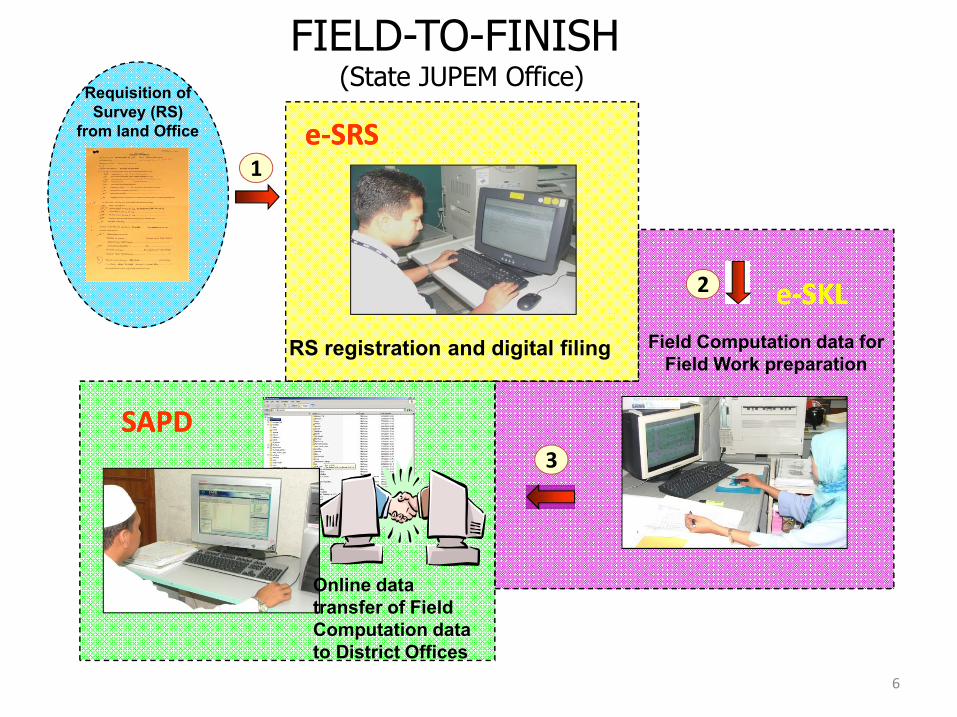
RS registration and digital filing Field Computation data for Field Work preparation
1
2
3
e-SRSe-SRS
FIELD-TO-FINISH (State JUPEM Office)
Requisition of Survey (RS)
from land Office
SAPDSAPD
e-SKLe-SKL
Online data transfer of Field Computation data to District Offices
6

FIELD-TO-FINISH (DISTRICT OFFICES ABD FIELD WORK)
Online data transfer of Field Computation data from State JUPEM
Field Survey
Determination of survey locality with TeleGPS
District Surveyor validate data from field
Field Officer processed and upload data into SAPD
Validated data uploaded online into State JUPEM
District Surveyor distribute survey job to Field Officers
4
5
SAPDSAPD STSSTS
7

Online data transfer between SAPD and
SPDKGenerate Calculation Volume and Certified Plan
CPSCPS
Updating DCDB and SPID Image Library
7
SPID
DCDB
DEPDEP
SPEKSPEKDCDB
Director of Survey and Mapping approved Certified Plan with Digital Certification
FIELD-TO-FINISH (State JUPEM Office)
6
Digital Title Plan send to Land Offices
Digital Certified Plan
8

MALAYSIA 9th DEVELOPMENT PLANeCADASTRE PROJECT
9

Expedite the delivery system;
Creation of the National Digital CadastralDatabase (NDCDB);
Creation of the Strata Database;
Provide infrastructure and GIS-ready information;and
Embark on satellite technology (GNSS)
10
Objective

Expedite the delivery system, the strategytaken consists of the following:
Change the existing survey procedure;Embark on the latest ICT approach in the
cadastral survey;Strengthen the existing survey regulation and
ruling; Integration with land related systems - Land
Office’s eTANAH, Licensed Land SurveyorBoard’s eLJT and Ministry of Natural Resourcesand Environment’s MyGDI.
11
Delivery System

To create the National Digital CadastralDatabase (NDCDB), the strategy takenconsists of the following:
Based on the successful implementation ofthe Melaka’s NDCDB;
A homogeneous and seamless database withsurvey accurate coordinate;
Based on the national geocentric datum(GDM2000) ;
Creation of Cadastral Control Infrastructure(CCI);
Support the implementation of utility mapping.12
NDCDB

To create 3D Strata Database, the strategytaken consists of the following:
Outsource the data capturing for 499,618strata parcels;
Embark on fully digital concept;
Provide 3D information.
13
Strata Database

To provide infrastructure and GIS-readyinformation, the strategy taken consists of thefollowing:
NDCDB will fully GIS-ready;
Create additional layer in the GIS LayerManagement System (eGLMS);
Support the creation of multipurpose cadastre.
14
GIS

To embark on satellite technology (GPS) incadastral survey, the strategy taken consists ofthe following:
Use of GNSS in field survey;
Utilization of MyRTKnet;
Deployment of real-time data processing.
15
GNSS

PROJECT eCADASTREWORKFLOW
16

• eLodgement• eKadasOnLine
JUPEM2U
CSRS
eNotification
Web GIS
• eSIM• eBorang• Ecadasonline• eKiosk• eReporting• eMonitoring
• eNotification
eCRM
eTSM
eSSM
Field
Strata
• Strata 3D viewer•Strata Data Entry LS
StrataGIS
SUM
eQC
eSPEK
SPEK
• DB Merging
• Lot overlap
• SUM LSA
Database
Maintenance
• SSO
• SPAK• EDM/GPS Calibration
• eSigning• eVerifier• PKI 2D Barcode• eAnnotation
Calibration
eReporting
eSupport
ePKIeMedmAS
• eReporting
Non GIS
SPAK
SecuritySPPK
• SPPK
ePU DRP
eGLMSDesktop GIS
• ePU
• eJalan• eTownKg• eAdminBdy• eHidrografi• eBangunan• eWarta• eGrid
• ePA• ePA(B)• ePA(S)• ePA(M)• ePA(W)• eB1• eB4• ePetakadas
eFEE• eFee
GLMS
PDUSSM
NDCDB
eSPID
Bldg Verification
GNSS Control
Total Stn Survey
17
Application Modules

LAND OFFICES
9
10 7
1
2
3
4
5
STATE JUPEM
Digital RS
Hardcopy Requisition of Survey (RS)
• Updated ePU Database
• SUM Server• LSA validation• Preliminary checking•To accept/reject
6
• Determine lot boundary• Field data capturing• Generating JUPEM ASCII• Data validation
• CRM Squad determine Cadstral Control point
• Validation Server• Detail checking• To accept/reject
• Updating Temp NDCDB
• CS digisign Temp NDCDB
• Updating NDCDB• Generate B1 Tiff
RTK Net
8
Posting B1 Tiff (Digital Title Plan) to Land Offices
Licensed Land Surveyors (LS)
• Registration of file• Scanning related documents• Generate ePU
• Registration of file• Import PU ASCII• Generate ePU
• Updated CSRS
JUPEM2UInternet
• KOMMS Server
18
eCADASTRE : WORKFLOW TITLE SURVEY

• Strata XML• 16 Fieldbook ASCII• Building Raster Plan• Lst File
Licensed Land Surveyors (LS)
LJT
Update Status
SUM
HQ
JUPEM2U
Register Strata File,Data Lodgement, Verifier, Updating Tempand Extraction Module
DataRepository
FB ASCII
Strata Survey Module +“Laser Ranging”
Survey Costing Module
TempPDUSSM
VERIFICATIONDATA
CS/ODDigisign
System Generate PA(B) Number
Land Offices
1
2
5
3
8
6
Query
In Order /Not In Order
Upload
2 LAYER•Provisional Block•Strata Block
Advised to Land Offices and cc to LS, LJT , JUPEM HQ and Land Owner
eSSM UNIT
INSPEKTORAT UNIT
STATE JUPEM
7
JUPEM2UInternet
JUPEM2UInternet
JUPEM2UInternet
PHASE 1
STANDARD PDUSSM UNIT
CSRS TempPDUSSM
Download
4
19
eCADASTRE : WORKFLOW STRATA SURVEY

CSRS
TEMPPDUSSM
3D Strata Viewer
B4 Title PlanPreparation Module
GeneratePA(B)
KOMMS
Land Offices
Update CSRS & Generate Scheme Number
1
6
5
7
2
B4 Title Plan
Generate
KOMMS
STATE JUPEM
PA(B) Preparation ModuleLS Login jupem2u
& Endorsed PA(B)
Licensed Land Surveyors (LS)
GenerateB4 Title Plan
eSSM UNIT
13
SPID
B4/PA(B)
PA(B)
CS
8
PTG Final approval
Acknoledgement to LS by sms
JUPEM2UInternet
JUPEM2UInternet
JUPEM2UInternet
JUPEM2U
4
3
PDUSSM
1012
B4
update
STANDARD PDUSSM UNIT
9
11
PHASE 2
20
eCADASTRE : WORKFLOW STRATA SURVEY

eCADASTRE APPLICATION MODULES
21

1. NDCDB
2. JUPEM2U
3. CSRS
4. ePU
5. eSIM
6. eNotification
7. eMonitoring
8. eReporting
9. eCRM
10. eTSM
11. SUM
12. eSPEK
13. eQC
14. DRP
15. eFee
16. eGLMS
17. eCadasOnline
18. eSRMS
19. PKI
20. eSupport
21. eKomms
22. PDUSSM
23. eSSM
22
Application Modules

NATIONAL DIGITAL CADASTRAL DATABASE (NDCDB)
23

Digital Cadastral Database (DCDB) contains allinformation obtained from cadastral survey jobs relatedto boundaries of land parcels.
The existing DCDB, which covers the entire country, wasdeveloped from historical survey data (conversion fromhardcopy Certified Plans to digital) as well as fromcurrent survey jobs.
Coordinates in the DCDB were obtained from severalmeans and contain varying, unpredictable, and un-quantified errors.
24
Background of NDCDB

Uncertainties of surveyed values are typical, but errorsare more common in some rural areas.
To be able to support a modern cadastral system, anaccurate positional record of the cadastre is imperative.The existing DCDB was not designed for this purpose.
25
Background of NDCDB

DIFFERENT TYPES OF CADASTRAL COORDINATES
RIGID COORDINATE
Homogenous and Systematically Adjusted
PLOTTING COORDINATE
For cadastral map plotting purposes
SYSTEM COORDINATE
System/Software generated coordinate based on features location
Rigid Coordinate Plotting Coordinate System Coordinate26
Background of NDCDB

Surveyed value
System value
27
Background of NDCDB

OLD AND NEW GEODETIC INFRASTRUCTURE:
G001
G003
G004
G005
G007
G008
G009
G010
G011
G012
G013
G015
G016
G017
G018
G019
G020
G021
G022
G023
G024
G025
G026
G027
G028
G029
G030G031
G032G033
G034
G035
G036
G037
G038 G039
G040
G041
G042
G043
G044
G045
G046
G047
G048
G049
G050
G051
G052
G053
G054
G055
G056
G057
G058
G059
G060
G061
G062
G063
G064
G065
G066
G067
G068
G069
G070
G071
G072
G073
G074G075
G076
G077
99.00 99.50 100.00 100.50 101.00 101.50 102.00 102.50 103.00 103.50 104.00
1.00
1.50
2.00
2.50
3.00
3.50
4.00
4.50
5.00
5.50
6.00
6.50
GEODETIC TRIANGULATIONPENINSULAR MALAYSIA
G002
G014
G084
P4
P075
GPS BASED REFERENCE SYSTEM
28
Background of NDCDB

Least Squares adjustment technique determine a unique set of
coordinates for each boundary mark from a set of observed values
(bearings & distances).
Bowditch adjustment distributes closing errors linearly but not
able to provide a unique coordinates solution.
GPS
GPS
Bowditch Least Squares
Non Rigorous Adjustment Technique for Coordinates Computation
29
Background of NDCDB

Establishing State Cadastral Control Infrastructure (CCI)
Tie-Up of Selected ParcelCorners to CCI
Development of State Cadastral Control Database (CCDB)
Populating DCDB with Survey Accurate Coordinates
Automated Re-CoordinationSystem
Finalized GeocentricBased Cassini & RSOCoordinates in DCDB
Establishmentof CCI andState CCDB
Repopulation &Re-coordinationof DCDB withSurvey AccurateCoordinates
Study on CadastralSurvey ProceduresUnder CCS
Cost-Benefit Analysis of CCS Implementation
THE METHODOLOGY :
30
NDCDB

CCDB
DCDB
DataIntegrity
Check
ConnectionLineFile
DataSelection
Adjustment
TransformationQualityControl
TempNDCDB
NDCDB
Editing
FORMATION OFCADASTRAL NETWORK
RE-COORDINATIONUSING ANAUTOMATEDDATA CONVERSIONSYSTEM (ADCS)
SURVEY ACCURATEDIGITAL CADASTRALDATABASE (NDCDB)
THE ADJUSTMENT :
31
NDCDB

CADASTRAL CONTROL INFRASTRUCTURE (CCI) EMPLOYINGWHOLE TO THE PART CONCEPT AND GPS TECHNOLOGY
Primary Grid
Secondary Grid
32
NDCDB

State of Johor CCI Point
33
NDCDB

GDM2000
Establishment of Cadastral Control Infrastructure (CCI)Using JUPEM MyRTKnet GPS Service
Tie-Up of Selected ParcelCorners to CCI
Automated Network Adjustment& Re-Coordination System
Re-coordination and Re-population (R&R)
NDCDB
Methodology For Cadastral Data Migration To The New Geocentric Datum For Malaysia (GDM2000) Expected NDCDB Spatial Accuracy
CATEGORY
Std Dev
Northing
Std Dev
Easting
Cadastral Control Spacing
Urban/ New Development
± 5 cm
or better
± 5 cm
or better 0.5 km
Semi Urban/Rural
± 10 cm
or better
± 10 cm
or better 2.5 km
Total estimated number of boundary marks to be re-coordinated is about 40 million boundary marks.
34
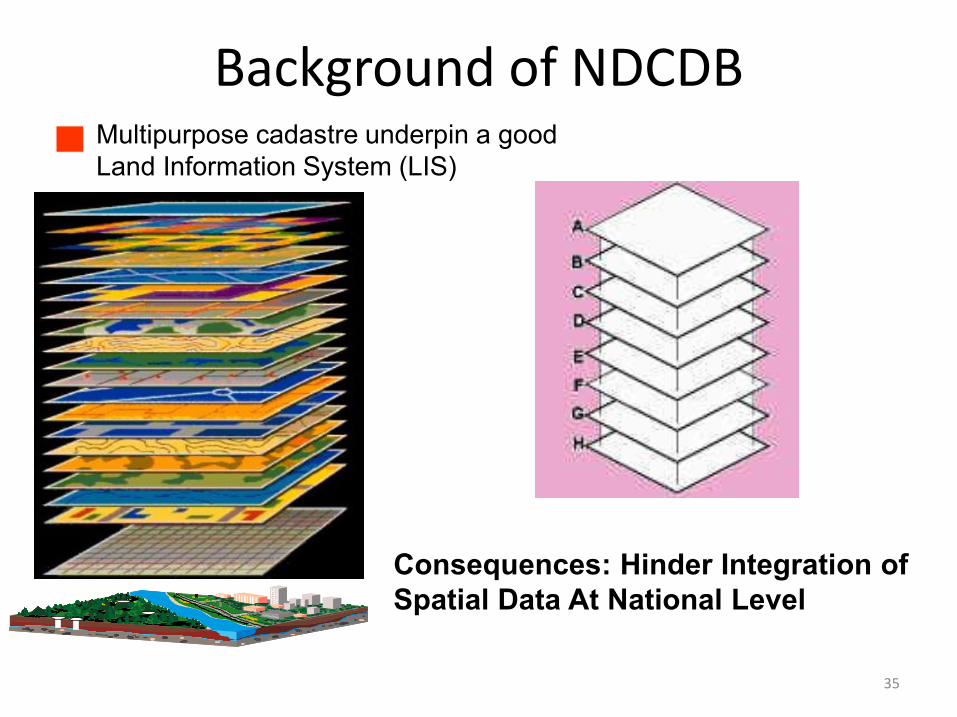
Consequences: Hinder Integration of Spatial Data At National Level
Multipurpose cadastre underpin a goodLand Information System (LIS)
35
Background of NDCDB

DistrictSurveyors
CSRS
JUPEM2U SUM eQC eSPEK
LS
600Parties
LS
600Parties
JUPEM
300Parties
NDCDB
36
NDCDB

JUPEM2U(Cadastral Working Portal)
37

JUPEM2U is the remote one-stop interface via theinternet for designated users to conduct their businesswith States’ JUPEM without being physically present atstates’ JUPEM offices;
JUPEM2U application is to developed using Webtechnologies incorporating MapInfo GIS engines andMapXtreme.
38
JUPEM2U

39
JUPEM2U

40
JUPEM2U

41
JUPEM2U

Application, ProcessingServers,
Workstations
District Surveyors
Field Officers
Licensed LandSurveyors (LLS)
LLS FieldOfficers
ww
w.JU
PEM
2U
.gov.m
y
FIREW
ALL
JUP
EM2
U SER
VER
We
b se
rver/KO
MM
serve
r/SUM
Databases,Files Servers
GatewayCSRS
• Application Systems
• Application Modules
• Data Communications
• Data Exchange
• System Integrations
• Networking
42
JUPEM2U

CSRS, eFEE, eCadasOnline(Cadastral Survey Record System, Survey Fee Module)
43

CSRS is a survey file management system;
eFee to calculate the actual survey fee after the Certified Plan is drawn and the job is completed;
eCadasOnline provide search and view of all survey information within the databases;
Application developed using Web technologies incorporating MapInfo GIS engines and MapXtreme.
44
CSRS, eFEE, eCadasOnline

45
CSRS

SURVEY FEE REPORT :
46
eFEE

47
eCadasOnline

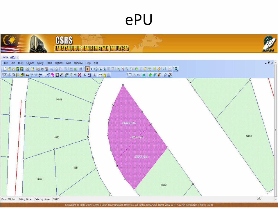
ePU(Request of Survey (RS) File Registration and Field
Tracing (eSKL) issuing)
48

ePU for survey file registration and produce of fieldtracing;
Application developed incorporating with MapInfo GISengines.
49
ePU
50
ePU
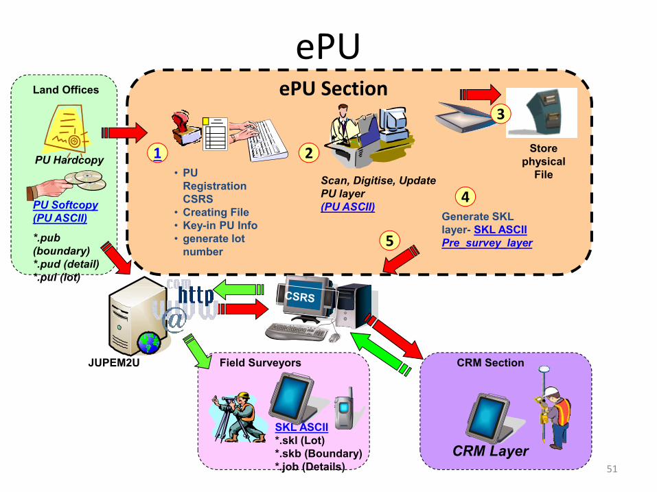
ePU Section
PU Softcopy (PU ASCII)
*.pub (boundary)*.pud (detail)*.pul (lot)
JUPEM2U
• PU Registration CSRS
• Creating File• Key-in PU Info• generate lot
number
Scan, Digitise, Update PU layer(PU ASCII)
Store physical
File
PU Hardcopy
Generate SKL layer- SKL ASCIIPre_survey_layer
1 2
4
3
5
SKL ASCII*.skl (Lot)*.skb (Boundary)*.job (Details)
Field Surveyors
CRM Layer
CRM Section
Land Offices
51
ePU

52
ePU-File Structure
53
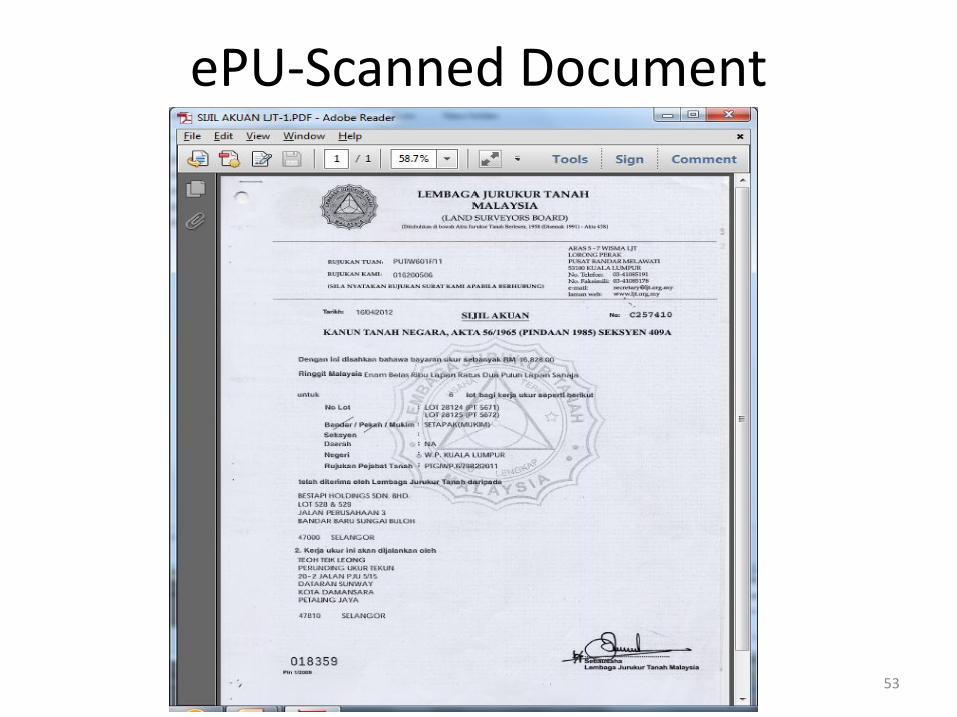
ePU-Scanned Document

54
ePU-SKL ASCII Sample

eCRM(Cadastral Reference Mark)
55

eCRM is a module with the aim of creating CRM pointswithin the eGLMS layer database;
Four (4) phases of processes in eCRM namely: Extraction,Establishment, Validation and Update;
Application developed incorporating with MapInfo GISengines.
56
eCRM

JUPEM2U
eCRM
- Planning- Establish CRM- Observation- Processing- Transform Module
Extract PU/QT & CRM Layer
1
3
2
CRM/CCI LAYER DATABASE
CRM Layer
Update
Internet
RTK net
GEOPORTAL
57
eCRM

58
eCRM

59
eCRM-File Structure

60
eCRM-File Structure

61
eCRM-Sample ASCII

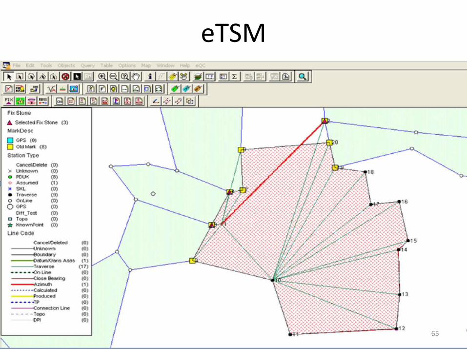
eTSM(Title Survey Module – Field Data Capturing)
62

eTSM is a module for field data capturing that comply withJUPEM Survey Regulation and practices;
Application developed incorporating with MapInfo GISengines.
63
eTSM

64
eTSM
65
eTSM

66
eTSM

67
eTSM-File Structure

68
eTSM-Sample ASCII

69

eSUM, eQC, eSPEK(Virtual Survey Module, Validation and Updating Module)
70

eSUM is a web-based application catered for the need toverify and validate the survey ASCII files submitted byJUPEM District Officer and Surveyors as well as fromLicensed Land Surveyors, using Least Square Adjustmentsoftware;
eQC is a module to validate surveyed data;
eSPEK using GIS engine to perform graphicalcomputations, spatial analysis and NDCDB Updating;
Application developed incorporating with MapInfo GISengines.
71
eSUM

Sistem Ukur Maya (SUM) is a web-based application allowing field officers to perform validation of survey data while in the field.
The online adjustment is carried out using Least Square Software.
72
eSUM

73
eSUM

74
eQC

75
eSPEK

DRP(Digital Raster Plan Module)
76
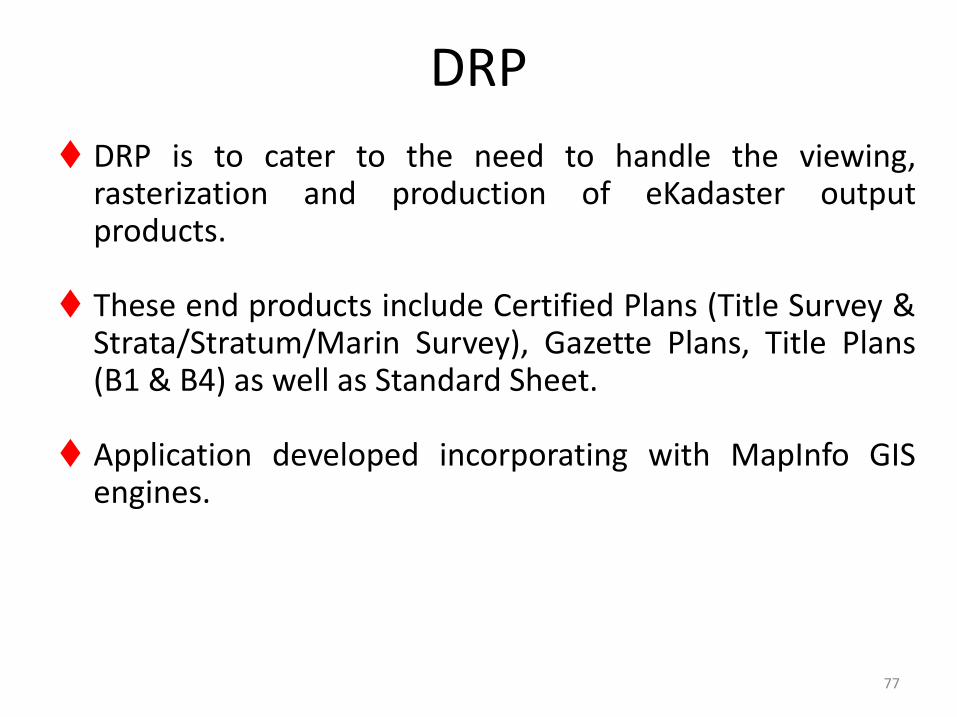
DRP is to cater to the need to handle the viewing,rasterization and production of eKadaster outputproducts.
These end products include Certified Plans (Title Survey &Strata/Stratum/Marin Survey), Gazette Plans, Title Plans(B1 & B4) as well as Standard Sheet.
Application developed incorporating with MapInfo GISengines.
77
DRP

78
DRP
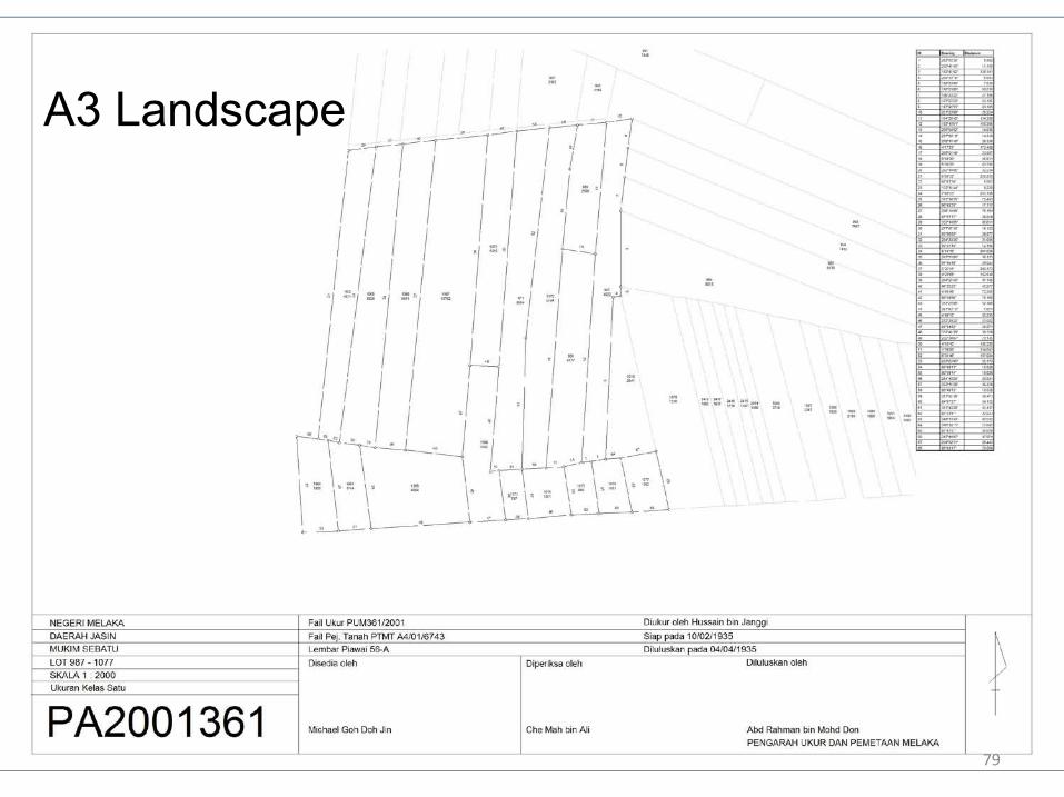
A3 Landscape
79

80
DRP

81
ePKI(Public Key Infrastructure )
82

• PKI authentication solutions comply to Malaysia’s DigitalSignature Act (DSA) 1997 and the Digital SignatureRegulation (DSR) 1998;
• Cater for digital authentication, digital signing and 2D barcoding with digital envelope;
• A complete PKI authentication solution from Malaysia’sCertification Authority (CA).
83
ePKI

84
ePKI

85
ePKI

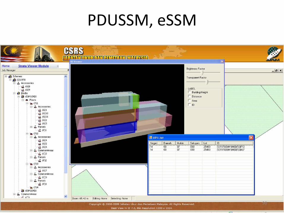
PDUSSM, eSSM(Strata Survey Database and Strata Survey Module)
86

To establish a digital strata database called PangkalanData Ukur Strata/Stratum/Marin (PDUSSM) with 2D and3D graphical information, as well as the necessary toolsto capture and manage the strata title plans digitally;
Strata Survey Module (eSSM) to allow surveyorsconduct verification survey for Strata parcels;
Application developed incorporating with MapInfo GISengines.
87
PDUSSM, eSSM

88
PDUSSM, eSSM

89
PDUSSM, eSSM
90
PDUSSM, eSSM

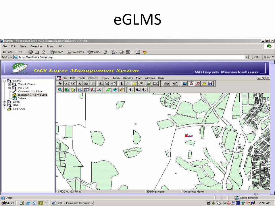
eGLMS(GIS Layer Management System)
91

To enhance the current GLMS layers and expanded tocater to the eCadastre implementation, particularly withthe establishment of NDCDB;
An enhanced process of updating and maintenance ofthese layers are performed;
Application developed incorporating with MapInfo GISengines.
92
eGLMS
93
eGLMS

eSupport(Fault Log Management System)
94

Enhance the present Fault Log Management System(FLMS) with additional functionalities;
Establish a paperless management and monitoringsystem;
Application developed incorporating with .NET engines.
95
eSupporty

96
eSupporty

97
eSupporty

T H A N K YO U
98