Embed Size (px)
Citation preview
1 | P a g e
Note to Reviewer: Deletions are indicated as stricken text. Additions and sections substantively rewritten for clarity are shown in red text. Office of the Chief Information Officer Arkansas Geographic Information 501.682.4300 Voice
Mike Huckabee, Governor 124 W. Capitol Ave. Suite 200 501.682.2040 Fax
Doug Elkins ECIO Little Rock, AR 72201 http://www.oit.state.ar.us
Cadastral Mapping
Standard
Document Number: SS-40
Effective Date:
Published By: Arkansas State
Land
Information Board

2 | P a g e
Arkansas Digital Cadastral
Mapping Standard
Arkansas GIS Board
Prepared By: Arkansas GIS Office
Presented to the Arkansas State Land Information Board –
Adopted by the Arkansas State Land Information Board –
Presented for Public Review –
Submitted to the Bureau of Legislative Research –
Reviewed by the Legislative Rules and Regulations Subcommittee –
Became an official state rule / regulation – July 2, 2004
Presented to Arkansas GIS Board for proposed revision – December 5, 2018
Proposed Revision Adopted by Arkansas GIS Board – December 5, 2018
Presented for Public Review –
Submitted to the Bureau of Legislative Research –
Final Rule Adopted by GIS Board –
Reviewed and Approved by the ALC - Administrative Rules & Regulations Subcommittee –
Approved by the Arkansas Legislative Council –
Became an official state rule / regulation –

3 | P a g e
Table of Contents
Introduction 3
Background and Purpose 3
Statutory References 3
Technical Practices
Creating a Cadastral Vector Layer
Heads-Up Digitizing
Metes and Bounds
Relative Dimension Accuracy
Cadastral Data Characteristics
Geometry
Attributes
Definitions
Additional Considerations
Procedures
Revision History
Related Resources
Inquiries
Appendix

4 | P a g e
Introduction
The State Land Information Board, now the Arkansas Geographic Information Systems Board,
first developed this standard in 2004 order to support the legislative initiatives to establish the
Arkansas Spatial Data Infrastructure (ASDI) (A.C.A. § 15-21-504). Spatial data layers are often
stored digitally and accessed through a relational database management system (RDBMS).
Although digital cadastral data is a component of the Arkansas Spatial Data Infrastructure
(ASDI), the ways in which users format and maintain it can differ, and they may often disagree
on the way a particular spatial data layer structure should be organized. This can pose problems
in terms of sharing, locating, and extracting spatial data information. It is intended that geospatial
data standards will benefit Geographic Information Systems (GIS) user communities through
consistency and efficiency of sharing the data.
1.0 Background and Purpose As articulated in A.C.A. § 15-21-504(f)(1), the Arkansas Geographic Information Systems (GIS)
Board, “…shall define technical specifications and standards to use in the collection,
distribution, and reporting of spatial information as required by the State of Arkansas Enterprise
Architecture.” A.C.A. § 15-21-501 further describes the purpose of the Arkansas GIS board in
detail.
The Arkansas Digital Cadastral Mapping Standard is intended to make digital cadastral data
more uniform and interoperable. This will facilitate the sharing of a statewide, seamless digital
cadastral spatial data layer. Adherence to this standard will enhance the “usability” of the
spatial data theme and its attributes by multiple entities, ensure a consistent manner in which the
cadastral parcel spatial data and attribute data are collected or stored, and enable the data to be
merged seamlessly and become transferable regardless of creator or jurisdictional boundaries.
Digital cadastral maps enable the assessor to more efficiently access parcel location and
information, reveal geographic relationships that affect property value, and provide a platform
for the visualization of data layers and analytical results. (2015. Standard on Digital Cadastral
Maps and Parcel Identifiers. IAAO)
This standard is intended to make digital cadastral data more uniform and accurate. This will
facilitate the sharing of a statewide, seamless digital cadastral spatial data layer. Adherence to
this standard will ensure the “usability” of the spatial data theme and its attributes by multiple
entities. This standard will ensure a consistent manner in which the cadastral parcel spatial data
and attribute data are collected or stored. This will enable the data to be merged seamlessly
and become transferable regardless of creator or jurisdictional boundaries.
2.0 Scope Provide a standard that will enable the seamless compilation of the digital cadastral spatial data
layer statewide.
3.0 Background

5 | P a g e
The State Land Information Board (SLIB) was created by Act 914 of the 1997 General
Assembly and is responsible for:
3.1 Identifying problems and solutions in implementing a spatial data repository
3.2 Developing and coordinating a schedule for state spatial data projects
3.3 Recommending methods of financing for state spatial data projects
3.4 Providing educational programs that are focused on spatial data technologies
3.5 Coordinating collaborative projects
3.6 Establishing spatial data standards (Section 4. (f) (1) of Arkansas Code
15-21-5). Arkansas Code 15-21-5 An Act to Amend the Arkansas Code to
Create the Geographic Information Office and Establish the Arkansas Spatial
Data Infrastructure and for other purposes establishes these SLIB principles:
3.7 Validity, consistency, comprehensiveness, availability, and currency of data
are essential components of all automated land information systems.
3.8 Coordination with federal, state, regional, county, and municipal agencies,
state universities and colleges, private firms, and others who require the
same spatial data will reduce duplication of efforts and expense.
3.9 Creation of new data in an accurate and usable format in accordance with the
states shared technology architecture will ensure availability across state
agencies.
4.0 Statutory References
Specific portions of Arkansas code pertain directly to and govern certain aspects and uses of
digital cadastre. Listed herein are those applicable instances (excerpted).
Arkansas Code 15-21-502 (6) – The digital cadastre manages and provides access to cadastral
information. Digital cadastre does not represent legal property boundary descriptions, nor is it
suitable for boundary determination of the individual parcels included in the cadastre.
Arkansas Code 15-21-502 (6) – “Digital cadastre” means the storage and manipulation of
computerized representations of parcel maps and linked data bases;
Arkansas Code 15-21-502(7) – “Framework data” means commonly needed data themes
developed, maintained, and integrated by public and private organizations within a geographic
area. These data themes include but are not limited to: digital cadastre, public land survey system
(PLSS), elevation, geodetic control, governmental units, hydrography, orthoimagery,
transportation, soils, and geology;
A.C.A. § 15-21-306. Technical definition of system -- Marking of coordinates on ground.
(a) For purposes of more precisely defining the Arkansas Coordinate System 1983, the
following definition by the National Geodetic Survey is adopted:
(1)
(A) The Arkansas Coordinate System 1983, North Zone, is a Lambert conformal
projection of the North American Datum of 1983 (NAD83), having standard
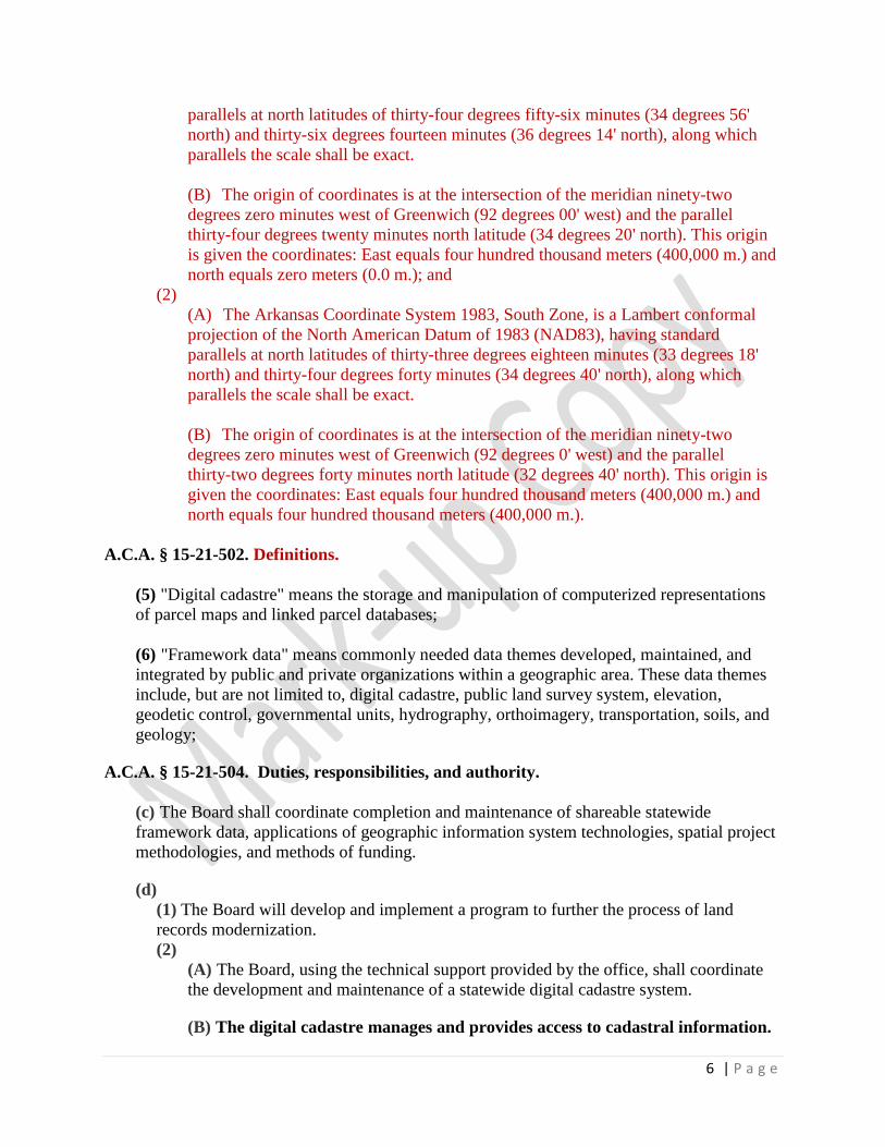
6 | P a g e
parallels at north latitudes of thirty-four degrees fifty-six minutes (34 degrees 56'
north) and thirty-six degrees fourteen minutes (36 degrees 14' north), along which
parallels the scale shall be exact.
(B) The origin of coordinates is at the intersection of the meridian ninety-two
degrees zero minutes west of Greenwich (92 degrees 00' west) and the parallel
thirty-four degrees twenty minutes north latitude (34 degrees 20' north). This origin
is given the coordinates: East equals four hundred thousand meters (400,000 m.) and
north equals zero meters (0.0 m.); and
(2)
(A) The Arkansas Coordinate System 1983, South Zone, is a Lambert conformal
projection of the North American Datum of 1983 (NAD83), having standard
parallels at north latitudes of thirty-three degrees eighteen minutes (33 degrees 18'
north) and thirty-four degrees forty minutes (34 degrees 40' north), along which
parallels the scale shall be exact.
(B) The origin of coordinates is at the intersection of the meridian ninety-two
degrees zero minutes west of Greenwich (92 degrees 0' west) and the parallel
thirty-two degrees forty minutes north latitude (32 degrees 40' north). This origin is
given the coordinates: East equals four hundred thousand meters (400,000 m.) and
north equals four hundred thousand meters (400,000 m.).
A.C.A. § 15-21-502. Definitions.
(5) "Digital cadastre" means the storage and manipulation of computerized representations
of parcel maps and linked parcel databases;
(6) "Framework data" means commonly needed data themes developed, maintained, and
integrated by public and private organizations within a geographic area. These data themes
include, but are not limited to, digital cadastre, public land survey system, elevation,
geodetic control, governmental units, hydrography, orthoimagery, transportation, soils, and
geology;
A.C.A. § 15-21-504. Duties, responsibilities, and authority.
(c) The Board shall coordinate completion and maintenance of shareable statewide
framework data, applications of geographic information system technologies, spatial project
methodologies, and methods of funding.
(d)
(1) The Board will develop and implement a program to further the process of land
records modernization.
(2)
(A) The Board, using the technical support provided by the office, shall coordinate
the development and maintenance of a statewide digital cadastre system.
(B) The digital cadastre manages and provides access to cadastral information.

7 | P a g e
Digital cadastre does not represent legal property boundary descriptions, nor is
it suitable for boundary determination of the individual parcels included in the
digital cadastre.
5.0 Standard Technical Practices
Technical Practices for Creating a Cadastral Vector Layer
Procedures
Cadastral Feature Types:
Vector points may be used to represent a parcel. The parcel point shall be located within the
parcel boundary.
Vector polygons shall be used to represent parcel boundaries. The parcel boundaries shall
“seamlessly” match across jurisdiction boundaries (i.e., cities, counties, etc.). Parcel boundaries
shall be processed using appropriate GIS procedures to create and maintain accurate topology.
Heads-Up Digitizing:
Parcel boundaries intended to meet the standard may be produced utilizing heads-up digitizing
techniques. Within the Cadastral Standard, heads-up digitizing methodologies refers to
georeferencing scanned paper maps and tracing the relevant parcel boundaries to create the
parcel features. Heads-up digitizing methodologies used may include but are not limited to
stream mode and arc/node mode. Heads-up digitizing shall be performed utilizing the following
recommendations standards:
• Capture scale shall not fall outside the range of 1:1200 to 1:3600
• Projection shall be Arkansas State Plane North or Arkansas State Plane South (See
Definitions for Projection for each county)
• Datum shall be as specified for the State of Arkansas in A.C.A. § 15-21-306
• Units shall be US Survey Feet
• Source shall be Digital Ortho-imagery not more than five years in age, meeting
industry-recognized standards for radiometry, a minimum of 1 foot resolution, and
having a minimum positional accuracy plus or minus 3.9 feet that has a verified
minimum horizontal accuracy of 10 meters or better, and a minimal pixel resolution of 1
meter. The Arkansas Digital Orthophotography Program (ADOP) imagery is
recommended.
• Heads-up digitizing method should only be used where clear visual ground evidence of
ownership is present on the Ortho-imagery (i.e., fence line, tree line, grass line, etc.)
Metes and Bounds:

8 | P a g e
Parcel boundaries may also be produced utilizing metes and bounds techniques. Metes and
bounds techniques pertain to the use of coordinate geometry with bearings and distances to
accurately map the parcel boundary. Bearing and distance source data used may include but are
not limited to legal descriptions, subdivision plats, and plats of survey. Metes and bounds
should be used when clear visual ground evidence of ownership is not present. Coordinate
geometry (COGO) should be implemented as much as possible to ensure consistency between
recorded instruments, other available digital maps, and the base map. Although coordinate
geometry is usually regarded as the most accurate method of base map construction, it is sound
practice to integrate the COGO work with existing reliable digital sources to ensure accuracy and
consistency and minimize the expense and effort of the duplication of existing digital work.
When inconsistencies between the property records and other mapping sources (i.e., photo
evidence) appear, a thorough investigation should be initiated to discover all the relevant
evidence to make the judgment for locating the element on the map accurately. The recorded
instrument remains the authoritative record upon which all property valuations must rely. If the
record conflicts with the evidence of the map, the recourse for the cadastral mapping specialist is
to identify the discrepancy for reconciliation by the proper authorized parties.
The purpose of the cadastral map is to help locate tax parcels, not to identify property
boundaries.
Relative Dimension Accuracy:
Relative dimension accuracy refers to the accuracy of the ‘digital representation’ of the parcel
boundary on the Ortho-imagery, in comparison with the legal description from the recorded deed
or plat. The relative accuracy is checked by measuring the parcel line of the ‘digital
representation’ and comparing that distance to the legal or platted distance difference in the
calculated acreage versus the acreage recorded from the deed or plat that is stored in the
Computer Assisted Mass Appraisal (CAMA) system. The relative accuracy of the ‘digital
representation’ shall fall within 5% of the deeded or platted dimension.
As compared to the parcel acreage recorded in the CAMA system, it is strongly recommended
that the calculated acreage for each parcel polygon be within acceptable suggested tolerances as
defined in Table 1. However, due to inherent variability in the various types of cadastral
records, e.g. CAMA record, deed, plats, etc., strict adherence to these tolerances may not be
practical.
Table 1: Acreage tolerances
Acreage Range Value
in CAMA
Percentage of Error Allowed in
GIS Calculated Acreage
5.00 – 8.00 15% +/-
8.01 -10.00 10%+/-
10.01-20.00 8%+/-
20.01-30.00 6%+/-
30.01-40.00 5%+/-
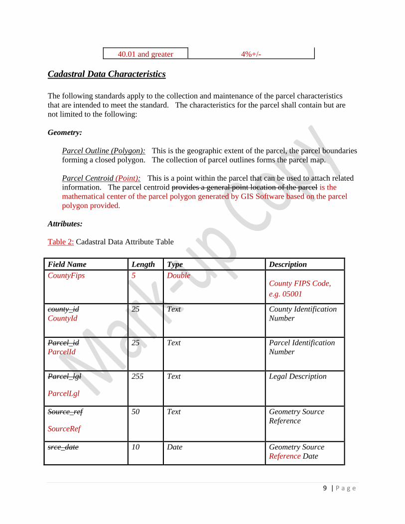
9 | P a g e
40.01 and greater 4%+/-
Cadastral Data Characteristics
The following standards apply to the collection and maintenance of the parcel characteristics
that are intended to meet the standard. The characteristics for the parcel shall contain but are
not limited to the following:
Geometry:
Parcel Outline (Polygon): This is the geographic extent of the parcel, the parcel boundaries
forming a closed polygon. The collection of parcel outlines forms the parcel map.
Parcel Centroid (Point): This is a point within the parcel that can be used to attach related
information. The parcel centroid provides a general point location of the parcel is the
mathematical center of the parcel polygon generated by GIS Software based on the parcel
polygon provided.
Attributes:
Table 2: Cadastral Data Attribute Table
Field Name Length Type Description
CountyFips 5 Double County FIPS Code,
e.g. 05001
county_id
CountyId
25 Text County Identification
Number
Parcel_id
ParcelId
25 Text Parcel Identification
Number
Parcel_lgl
ParcelLgl
255 Text Legal Description
Source_ref
SourceRef
50 Text Geometry Source
Reference
srce_date 10 Date Geometry Source
Reference Date

10 | P a g e
SourceDate
ow_name
OwnerName
50 Text Owner Name
ow_add 80 text Full owner address
ow_src_dat 10 date Owner source date
ph_rd_num
AdrNum
10 Double
Long integer
Physical Road
Number
ph_pre_dir
PreDir
2 Text Physical Prefix
Direction
Primary Directional
Prefix
ph_rd_nam
PstrNam
72 Text Physical Road Name
Primary Street Name
ph_rd_typ
PstrType
4 Text Physical Road Type
Primary Street Type
ph_suf_dir
PsufDir
2 Text Physical Suffix
Direction
Primary Directional
Suffix
ph_city_nam
AdrCity
32
50
Text Physical Community
Name
Physical City Name
11 | P a g e
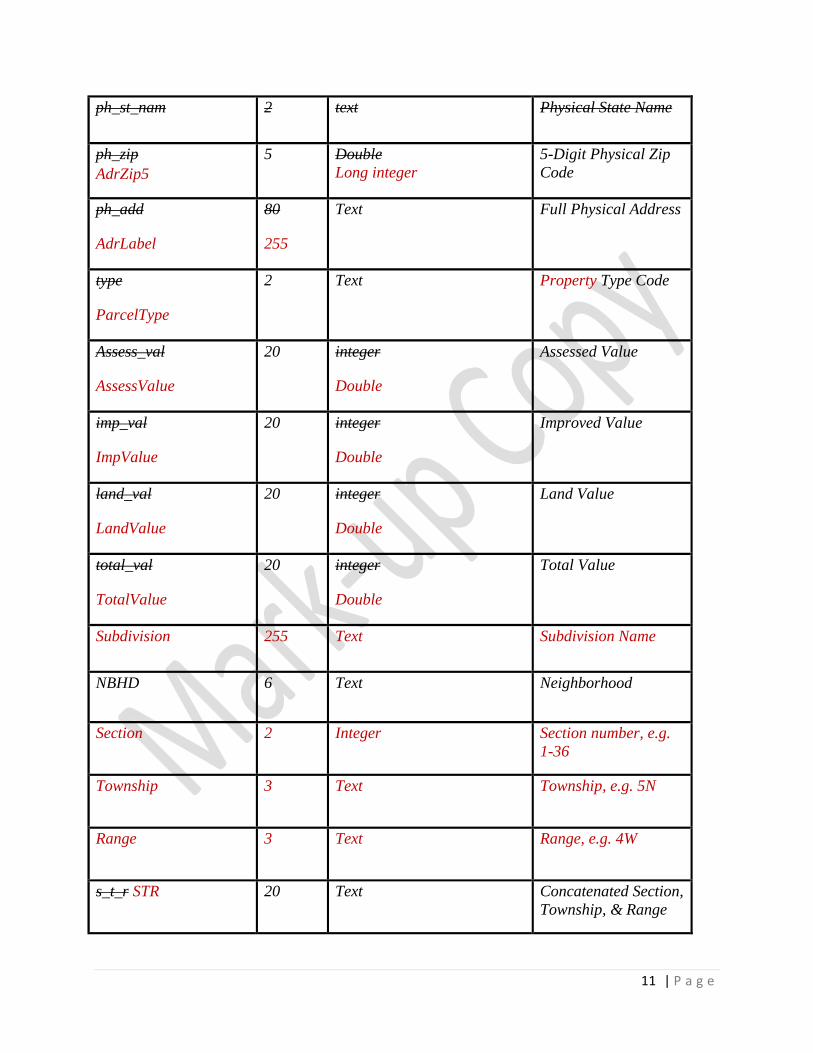
ph_st_nam 2 text Physical State Name
ph_zip
AdrZip5
5 Double
Long integer
5-Digit Physical Zip
Code
ph_add
AdrLabel
80
255
Text Full Physical Address
type
ParcelType
2 Text Property Type Code
Assess_val
AssessValue
20 integer
Double
Assessed Value
imp_val
ImpValue
20 integer
Double
Improved Value
land_val
LandValue
20 integer
Double
Land Value
total_val
TotalValue
20 integer
Double
Total Value
Subdivision 255 Text Subdivision Name
NBHD 6 Text Neighborhood
Section 2 Integer Section number, e.g.
1-36
Township 3 Text Township, e.g. 5N
Range 3 Text Range, e.g. 4W
s_t_r STR 20 Text Concatenated Section,
Township, & Range

12 | P a g e
schl_code
TaxCode
6 Text Tax School Code
acre_area
TaxArea
10 text
Double
Acreage/Area
Area Used for Tax
Purposes
Calc_area 10 text Calculated Acreage
CAMAKey 15 Double Unique Key used in
CAMA
CAMAProv 25 Text A County’s CAMA
System Provider
County 25 Text Responsible County
DataProv 25 Text Entity who provided
parcel data to the
Arkansas GIS Office
CAMADate 10 Date Date of CAMA
database extract
PubDate 10 Date Date of Publication to
the ASDI
NatCoordSys 25 Text Native Coordinate
System
Definitions Acreage – Refers to the common square measure of land described in the land tenure system.
One acre equals 43,560 square feet.
AdrCity: City associated with the physical address of the property. Physical Road Number AdrNum: Physical address road number of the property as seen in the
address point recommendations.

13 | P a g e
Physical Zip Code AdrZip5: Physical address Zip Code of property as seen in the address point
recommendations. Assessed Value: This attribute is the monetary amount at which a property is put on the
Assessment roll.
Assessment Date: This is the date in which the most recent assessment has been completed.
Attribute(s) – Properties and characteristics of spatial data entities.
Cadastral – Showing or recording property boundaries, subdivision lines, buildings, and related
details.
Cadastre – An official register of the quantity, value, and ownership of real estate used in
apportioning taxes.
Calculated Acreage: This is the attribute containing the calculated acreage. It is calculated by
the GIS software and can be compared to the deeded acreage to verify the consistency of the
data.
CAMA: An acronym meaning “Computer Assisted Mass Appraisal”.
CAMADate: The effective date of the CAMA database. Typically, this would be the date the
database was extracted from a county’s CAMA system.
CAMAKey: Unique key used by the county’s Computer Assisted Mass Appraisal Company.
CAMAProv: A county’s CAMA system provider. This is the vendor from which a county
procures its CAMA system.
Character – Also known as text or alpha
County: This attribute contains the name of the county responsible for the parcel polygons.
County FIPS Code: The FIPS county code is a five-digit Federal Information Processing
Standard (FIPS) code (FIPS 6-4) which uniquely identifies counties and county equivalents in
the United States, certain U.S. possessions, and certain freely associated states.
County Identification Number: A unique identifier for the parcel, using a combination of the
County FIPS code and the Parcel Identification Number.
DataProv: This attribute contains the name of the entity who provided parcel data to the
Arkansas GIS Office.
Digital Cadastre – The storage and manipulation of computerized representations of parcel

14 | P a g e
map and linked parcel databases (as defined by A.C.A. § 15-21-502(5)).
Entity – Any object about which an organization chooses to collect data.
Geometry Source Reference: This is a pointer to or an attribute describing the source reference
for the parcel. This can be a document number, book/page, or a map of survey. The geometry
source reference should describe the source of the parcel geometry, either the centroid or the
parcel outline. This should represent the latest and most accurate document available.
Geometry Source Reference Date: The effective date of the Geometry Source Reference.
This date is a general indication of the currency of the source. This is the date entered into the
CAMA system as the date the deed was filed. It is the date as of which the source
documentation was valid.
Georeferencing – Software procedure that consists in positioning, through points with known
coordinates (check points), scanned paper images in the respective area of the real territory
according to a given reference system.
Improved Value: This attribute is the monetary amount of any improvements that have been
made to the land.
Land Value: This attribute is the monetary amount of the land without improvement.
NatCoord: This attribute indicates whether the native coordinate system for the county is
Arkansas State Plane North or South.
Neighborhood: This attribute is used to represent geographical or market areas.
Owner Name: Name of the property owner.
Owner Address: An indication of the property owner address, not necessarily the parcel
physical address. Used by the Assessors office for sending mail to parcel owner.
Ownership Source Date: This is a pointer to or an attribute describing the source reference date
for the current owner of record.
Parcel Identification Number: A unique identifier for the parcel as defined by the Computer
Aided Mass Appraisal system (CAMA).
Parcel Legal Description: This is the deeded legal boundary for the parcel contained in the
CAMA system.
Property Type Code: A code indicating the property’s use or classification at the time of
reappraisal. Commonly used codes would represent uses such as residential, commercial, or
agricultural, among others, and typically indicate the presence of an improvement on the
property. A list of approved property type codes is available from the Arkansas Assessment

15 | P a g e
Coordination Department (AACD). Information on codes used by specific counties should be
obtained directly from the county assessor’s office. Below is a list of possible type codes.
Physical Community Name: Physical address Community name of property.
Physical Prefix Direction PreDir: Physical address prefix direction of property Primary
Directional Prefix as defined in the State Addressing standard.
Physical Road Name PstrNam: Physical address road name of property Primary Street Name
as defined in the State Addressing standard.
Physical Road Type PstrType: Physical address road type of property Primary Street Type as
defined in the State Addressing standard.
Physical State Name: Physical address State name of property.
Physical Suffix Direction PsufDir: Physical address suffix direction of property Primary
Directional Suffix as defined in the State Addressing standard. Physical Address AdrLabel: Concatenated full physical address of property.
Projection – State Plane Arkansas North and South Zone
North- Baxter, Benton, Boone, Carroll, Clay, Cleburne, Conway, Craighead, Crawford,
Crittenden, Cross, Faulkner, Franklin, Fulton, Greene, Independence, Izard, Jackson,
Johnson, Lawrence, Logan, Madison, Marion, Mississippi, Newton, Perry, Poinsett,
Pope, Pulaski, Randolph, Scott, Searcy, Sebastian, Sharp, St. Francis, Stone, Van Buren,
Washington, White, Woodruff, and Yell.
South- Arkansas, Ashley, Bradley, Calhoun, Chicot, Clark, Cleveland, Columbia,
Dallas, Desha, Drew, Garland, Grant, Hempstead, Hot Spring, Howard, Jefferson,
Lafayette, Lee, Lincoln, Little River, Lonoke, Miller, Monroe, Montgomery, Nevada,
Ouachita, Phillips, Pike, Polk, Prairie, Saline, Sevier, and Union.
Relative Accuracy – A measure of the accuracy of individual features on a map when compared
to other features on the same map.
Section, Township, & Range: This attribute indicates the parcel location by Section,
Township, and Range. The format for this field should be SX_TXDirection_RXDirection,
Direction for Townships being N or S and Direction for Ranges being E or W.
Subdivision: The name of any subdivision the parcel is located in. Examples are: Jones
Addition, Original City of Little Rock, Smith Subdivision Etc.
Acreage/Area Tax Area: This is the attribute containing the area being taxed. This is the value
that should be used on all cartographic displays of the data.

16 | P a g e
School Tax Code: This attribute represents the tax district. Topology – Spatial relationships and connectivity among graphic GIS features, such as points,
lines, and polygons. These relationships allow display and analysis of “intelligent” data in GIS.
Many topological structures incorporate begin and end relationships, direction and right/left
identification. Accurate Topology will ensure that there are no gaps or sliver between adjacent
parcels, as well as no overlapping parcels.
Total Value: This attribute is the monetary amount of the Improved Value plus the Land Value.
PROPERTY TYPE CODES
AI Agriculture Improved AV Agriculture Vacant AM Agriculture Miscellaneous RI Residential Improved RM Residential Miscellaneous RV Residential Vacant CI Commercial Improved CM Commercial Miscellaneous CV Commercial Vacant II Industrial Improved IM Industrial Miscellaneous IV Industrial Vacant PS Public Service EX Exempt MN Mineral MH Mobile home only IO Improvement only VP Void Parcel RC Reference Card
Additional Considerations
Update/Maintenance: The county assessor’s office is the responsible entity tasked with
creating, maintaining and updating the parcel data. The data shall be maintained in the native
coordinate system defined for the county and be delivered to the State in the same coordinate
system. Following spatial or attribute updates or modifications performed to the parcel boundary
data, it shall be submitted to the entity responsible for performing quality control practices.
Quality Control: Rigorous quality control techniques shall be implemented to ensure the parcel
data has acceptable horizontal accuracy and attribute integrity, such as building and maintaining
topology, visual and measurement accuracy checks.
Metadata: Cadastral data intended to meet the standard shall have Federal Geographic Data
Committee (FGDC) compliant metadata created for each spatial data file. Compliant metadata
shall be provided with Digital Cadastre that are created, updated, or distributed by any parties
intended to meet the standard. The metadata shall be supplied anytime it is distributed or

17 | P a g e
transferred among participants or other entities responsible for creating, performing quality
control, maintaining, updating, and/or distributing the data. The metadata shall be transferred in
a FGDC standard format (i.e., –Z39.5, text, HTML file, etc.) and must have successfully passed
through a FGDC compliant metadata parser.
Distribution: The ‘Digital Cadastre’ data shall be distributed digitally via
http://gis.arkansas.gov/ GeoStor,Arkansas’ Spatial Data Warehouse, at no fee to private or
public users.
6.0 Procedures
The agency shall be able to demonstrate compliance.
7.0 Revision History
Date Description of Change
05/30/2002 Original standard statement published
07/02/2004 Standard became effective
TBD Revision became effective
8.0 Definitions
9.0 Related Resources National Spatial Data Infrastructure (NSDI) – Cadastral Data Content Standard
World Wide Web: http://www.fairview-industries/fgdc-cad.html
http://nationalcad.org/CadStandards/CadStand.html
International Association of Assessment Officers (IAAO) - Standard on Digital Cadastral Maps
and Parcel Identifiers World Wide Web: https://www.iaao.org
Arkansas Centerline File Standard World Wide Web:
http://gis.arkansas.gov/docs/law/20180420_ACF_Standard_Final.pdf
Arkansas Standards for Collecting Mapping Grade Global Positioning System Positions World
Wide Web: http://www.gis.state.ar.us/Downloads/LIB/gps_standards.pdf
10.0 Inquiries
Direct inquiries about this standard to:
Arkansas Geographic Information Systems Office
1 Capitol Mall, Suite 6D 124 W. Capitol St.
Little Rock, AR 72201

18 | P a g e
http://gis.arkansas.gov/ http://www.gis.state.ar.us
501-682-2767 2937
All inquiries regarding property taxes and associated assessments or approved property type
codes within the State of Arkansas should be directed to:
Arkansas Assessment Coordination Department
900 W. Capitol Ave, Suite 320
Little Rock, AR 72201
(501) 324-9240
https://www.arkansasassessment.com/
For inquiries regarding specific properties, please contact the appropriate county assessor.


![West Bengal [Digitization of Cadastral Maps & Integragration of Spatial & Textual Data]](https://img.dokumen.tips/doc/110x75/557206a3497959fc0b8b9682/west-bengal-digitization-of-cadastral-maps-integragration-of-spatial-textual-data.jpg)


