Embed Size (px)
Citation preview

GREATER GEELONG PLANNING SCHEME
AMENDMENT C321 & PLANNING PERMIT 1234/2014
REZONING TO THE MIXED USE ZONE AND
ACCOMMODATION/ RETAIL COMPLEX 30-42
GEELONG ROAD, PORTARLINGTON
PART A Submission to the Independent Panel
Panel: David Merrett (Chair), Peter Edwards
Date circulated: Tuesday 7 June 2016
Prepared by: Peter Schembri, Senior Strategic Planner &
Roger Munn, Acting Statutory Planning Team Leader
on behalf of the City of Greater Geelong

_________________________________________________________________________________________
City of Greater Geelong C321 PART A Submission Page 2
TABLE OF CONTENTS
1 INTRODUCTION ............................................................................................................................ 4
1.1 SUMMARY OF THE AMENDMENT AND PERMIT ..................................................................... 4 1.2 SUMMARY OF THE MAIN ISSUES ........................................................................................ 4 1.3 INFORMATION SUPPLIED IN THIS SUBMISSION .................................................................... 5
2 SITE DESCRIPTION AND CONTEXT ............................................................................................ 6
2.1 OVERALL CONTEXT – BELLARINE PENINSULA .................................................................... 6 2.2 PORTARLINGTON CONTEXT .............................................................................................. 7 2.3 THE SUBJECT LAND AND SURROUNDS .............................................................................. 9 2.4 EXISTING ZONING AND OVERLAYS ................................................................................... 12 2.5 ABORIGINAL HERITAGE AND BUSHFIRE MAPPING ............................................................. 15 2.6 PORTARLINGTON STRUCTURE PLAN MAP ....................................................................... 17 2.7 PLANNING HISTORY OF THE COMMERCIAL PRECINCT ........................................................ 18 2.8 PORTARLINGTON STRUCTURE PLAN 2007 ...................................................................... 21 2.9 PORTARLINGTON STRUCTURE PLAN 2016 ...................................................................... 23 2.10 VICTORIAN COASTAL STRATEGY 2014 ............................................................................ 24 2.11 G21 REGIONAL GROWTH PLAN ...................................................................................... 25 2.12 BELLARINE PENINSULA LOCALISED PLANNING STATEMENT .............................................. 26 2.13 OTHER RELATED PLANNING SCHEME AMENDMENTS AND POLICIES .................................. 28
3 DESCRIPTION OF AMENDMENT C321 AND PERMIT 1234/2014 ............................................. 31
3.1 THE ORIGINAL APPLICATION ........................................................................................... 31 3.2 ENVIRONMENTAL AUDIT OVERLAY .................................................................................. 32 3.3 DRAFT PLANNING PERMIT 1234/2014 ............................................................................ 37
4 CONSIDERATION OF THE PROPOSAL ..................................................................................... 44
4.1 ASSESSMENT AGAINST PLANNING POLICY ....................................................................... 44 4.2 CONSIDERATION AGAINST THE STATE PLANNING POLICY FRAMEWORK ............................. 44 4.3 CONSIDERATION AGAINST THE MUNICIPAL STRATEGIC STATEMENT .................................. 55 4.4 CONSIDERATION AGAINST THE MIXED USE ZONE ............................................................. 59 4.5 CONSIDERATION AGAINST CLAUSE 55 (RESCODE) .......................................................... 60 4.6 CONSISTENCY WITH THE PORTARLINGTON STRUCTURE PLAN 2007 ................................. 61 4.7 CONSISTENCY WITH THE PORTARLINGTON STRUCTURE PLAN 2016 ................................. 62 4.8 CONSISTENCY WITH THE VICTORIAN COASTAL STRATEGY 2014 ....................................... 63 4.9 OVERVIEW OF TECHNICAL ISSUES ................................................................................... 64
5 EXHIBITION AND SUBMISSIONS ............................................................................................... 66
5.1 COUNCIL RESOLUTION TO PREPARE AND EXHIBIT AN AMENDMENT .................................... 66 5.2 MINISTERIAL AUTHORISATION ......................................................................................... 66 5.3 EXHIBITION .................................................................................................................... 66 5.4 SUBMISSIONS RECEIVED ................................................................................................ 66 5.5 COUNCIL RESOLUTION REGARDING THE CONSIDERATION OF SUBMISSIONS ....................... 69
6 PART B SUBMISSION ................................................................................................................. 70
APPENDICIES ....................................................................................................................................... 71
APPENDIX 1 - PLANNING PERMIT ASSESSMENT REPORT .......................................................... 72 APPENDIX 2 - RESPONSE TO STRATEGIC ASSESSMENT GUIDELINES ......................................... 73

_________________________________________________________________________________________
City of Greater Geelong C321 PART A Submission Page 3
LIST OF FIGURES
Figure 1 - Overall Context Bellarine Peninsula ....................................................................................... 7
Figure 2 - Zoning Map Portarlington ....................................................................................................... 8
Figure 3 - Aerial Photo of Subject Land and Surrounds ......................................................................... 9
Figure 4 - Land Owners and Occupiers Map ........................................................................................ 10
Figure 5 - Existing Zoning ..................................................................................................................... 13
Figure 6 - Existing Overlays ................................................................................................................. 14
Figure 7 - Aboriginal cultural heritage sensitivity mapping.................................................................... 15
Figure 8 - Bushfire Prone Areas ........................................................................................................... 16
Figure 9 - Clause 21.14-5 Portarlington Structure Plan Map ................................................................ 17
Figure 10 - 2007 Portarlington Structure Plan Map (Amended 23 September 2008) ........................... 21
Figure 11 - 2016 Adopted Portarlington Structure Plan Map ................................................................ 23
Figure 12 - BPLPS Framework Plan..................................................................................................... 27
Figure 13 - Portarlington Recreation Reserve Master Plan November 2011 ........................................ 30
Figure 14 - Exhibited rezoning map ...................................................................................................... 40
Figure 15 - Exhibited change to Clause 21.14-5 .................................................................................. 41
Figure 16 - Exhibited Environmental Audit Overlay map ...................................................................... 42
Figure 17 - Exhibited perspective plans for PP1234/2014 .................................................................... 43
Figure 18 - Map 3 Central Coast (Victorian CASS Strategy, DSE 2009) .............................................. 50
Figure 19 - Greater Geelong & Bellarine Tourism Development Plan: Priority Projects ....................... 54
Figure 20 - Map showing location of submitters ................................................................................... 68

_________________________________________________________________________________________
City of Greater Geelong C321 PART A Submission Page 4
1 Introduction
This Submission has been prepared by the Planning Authority, the City of Greater
Geelong, and seeks the Panel’s support for Amendment C321 and concurrent
Planning Permit 1234/2014.
1.1 Summary of the Amendment and Permit
Amendment C321 is a combined rezoning and planning permit application pursuant
to Section 96A of the Planning and Environment Act 1987. The application has
been lodged by Batman Management Group Pty Ltd on behalf of the owner of 30
and 32 Geelong Road, Portarlington; being Grabble Pty Ltd.
The application seeks to rezone the land at 30, 32, 34, 36-38, 40 and 42 Geelong
Road, Portarlington (the ‘subject land’), from the Commercial 2 Zone (C2Z) to the
Mixed Use Zone (MUZ). The Amendment also proposes to apply the Environmental
Audit Overlay to all the land being rezoned.
The Portarlington Structure Plan map at Clause 21.14-5 of the Greater Geelong
Planning Scheme will be changed as part of Amendment C321 to reflect the
removal of the commercial zone.
This commercial precinct is developed with buildings used for seafood retail,
recycled clothing and furniture, automotive and marine repairs, blinds sales, as well
as some vacancies. The precinct is surrounded by residential land other than to the
north where the Portarlington Recreation Reserve is located. The precinct gains
access from Geelong Road, the primary road into Portarlington.
The Planning Permit Application (Permit Ref No. 1234/2014) is for buildings and
works to construct an Accommodation/ Retail Complex at 30 and 32 Geelong Road,
Portarlington plus other consequential permit triggers. A draft permit was exhibited
with the Amendment.
1.2 Summary of the main issues
The exhibition of the amendment and concurrent planning permit has resulted in the
receipt of 35 submissions (plus petition), being made on the following key issues:
• Rezoning the precinct to the Mixed Use Zone is not supported;
• Benefits to the local tourist industry and business community;
• The building height and bulk is out of character for Portarlington;

_________________________________________________________________________________________
City of Greater Geelong C321 PART A Submission Page 5
• The building will have an adverse impact on views;
• Traffic and car parking concerns; and
• General amenity concerns and benefits.
1.3 Information supplied in this Submission
In accordance with Panel Direction no. 11 this Submission includes the following
information:
a. Background to the Amendment and permit
b. Chronology of events
c. Strategic context and assessment of the Amendment and permit
d. Identification of issues raised in submissions
e. How the Type 1 Apartment accesses natural light in the bedroom
f. Changes to the Amendment documentation and permit proposed as a result
of the issues raised in submissions or Direction 9*.
*Direction 9 requires Council to advise the Panel:
a. How it has satisfied itself that the environmental conditions of the site is
suitable for the sensitive use.
b. Whether a permit condition is proposed to address this issue and what the
preferred text may be.

_________________________________________________________________________________________
City of Greater Geelong C321 PART A Submission Page 6
2 Site description and context
2.1 Overall context – Bellarine Peninsula
The Bellarine Peninsula is located approximately 90 kilometres from Melbourne and
12 kilometres from the urban area of Geelong. It features distinct townships set
amongst open farmed landscapes, significant wetland areas, and ocean and bay
beaches. Most towns are located along the coast, are popular with holiday makers,
and in recent years have attracted increasing numbers of permanent residents.
ABS Census data indicates that in 2011 the population of the Bellarine Peninsula
was 51,700, representing a growth rate of 2.8% over the previous 10 years. The
key areas where population increases occurred were Ocean Grove and Leopold
(and now also Drysdale). These towns are identified in the Greater Geelong
Planning Scheme and G21 Regional Growth Plan as designated growth areas and
play a key role as district towns servicing the growing population, nearby smaller
townships and surrounding rural and rural living areas.
Structure Plans have defined clear settlement boundaries for townships on the
Bellarine which enable protection of the rural and coastal landscapes. Forecast
growth in the region and Melbourne, when combined with increased tourism, will
continue to place pressure on the natural assets of the Bellarine Peninsula.
Figure 1 shows the location of Portarlington and the direct road connections to
other towns on the Bellarine Peninsula.

_________________________________________________________________________________________
City of Greater Geelong C321 PART A Submission Page 7
Figure 1 - Overall Context Bellarine Peninsula
2.2 Portarlington context
Portarlington is the northern most point on the Bellarine Peninsula and is an older
settlement with strong links to its history as a fishing town and holiday resort.
Portarlington is not a designated residential growth location. Geelong Road is the
primary road that conveniently connects Portarlington to Drysdale, Geelong and
Melbourne.
Portarlington is highly valued for its coastal landscape setting and the surrounding
hills that provide a natural backdrop to the settlement. Acclaimed wineries including
Jack Rabbit, Teringah Estate and Spray Farm are located in this area. The town
itself has a low density suburban character of wide open streets and mainly one and
two storey dwellings in garden settings.
The permanent population of Portarlington was 3,226 at the 2011 census and is
currently estimated to be 3,576. This is forecast to grow to around 4,530 people by
2031. The town’s population swells considerably during the summer holiday
season, peaking at 16,678 (Geelong Economic Indicators Bulletin 2013).
The town is well served by recreation and foreshore reserves and has an attractive,
historic commercial centre overlooking the pier and harbour. Community facilities

_________________________________________________________________________________________
City of Greater Geelong C321 PART A Submission Page 8
include a primary school, community health centre, municipal halls, and police and
CFA stations. Similar to the nearby towns of St Leonards and Indented Head,
Portarlington relies heavily on Drysdale and Geelong for most of its employment,
retail and social needs.
Though not a designated location for residential growth, development is expected to
continue within the Arlington Rise Estate and the Mercer Street retirement village.
The ‘Olive Grove’ growth area will further add to the town’s housing supply in the
future.
Figure 2 is a zoning map of Portarlington and surrounding uses. The subject land is
highlighted.
Figure 2 - Zoning Map Portarlington

_________________________________________________________________________________________
City of Greater Geelong C321 PART A Submission Page 9
2.3 The Subject Land and Surrounds
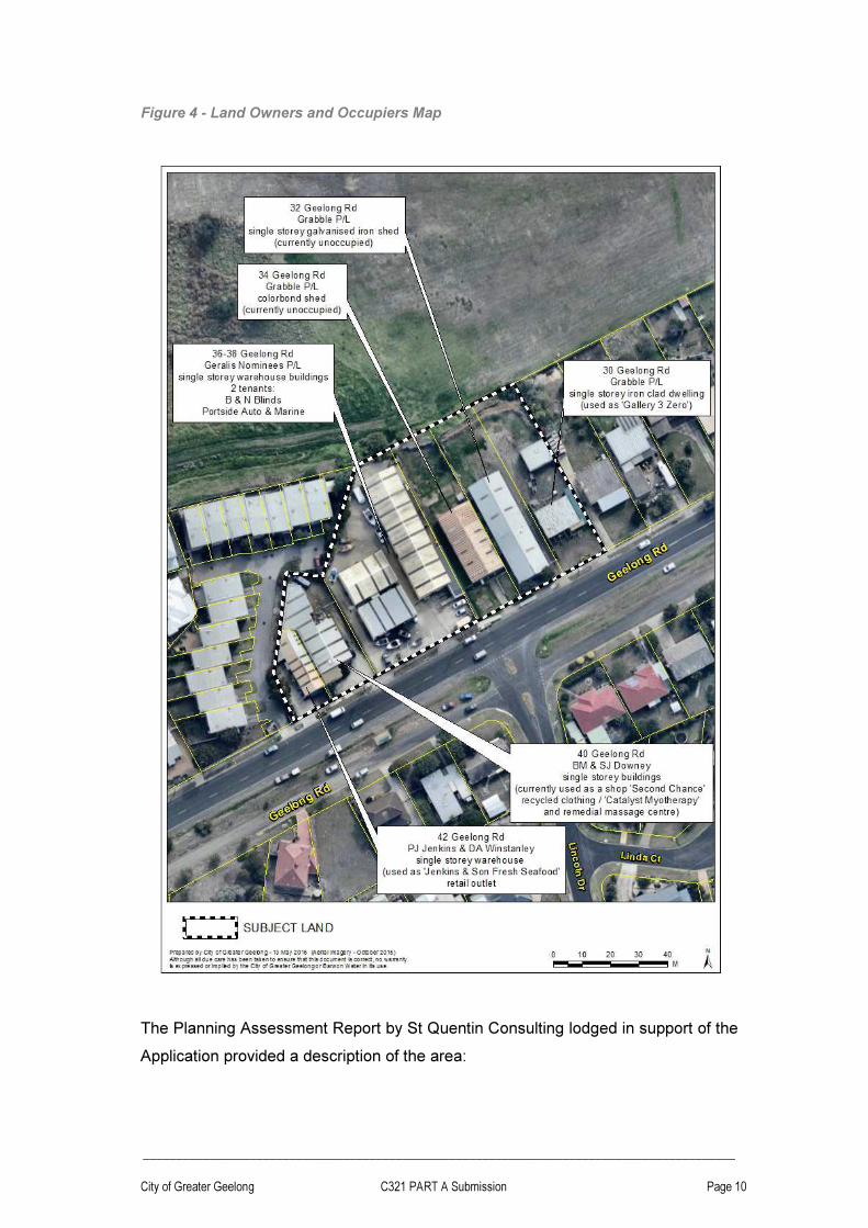
The subject land is shown in the Aerial Photo in Figure 3 and a Landowners and
Occupiers map is shown in Figure 4.
Figure 3 - Aerial Photo of Subject Land and Surrounds
_________________________________________________________________________________________
City of Greater Geelong C321 PART A Submission Page 10
Figure 4 - Land Owners and Occupiers Map
The Planning Assessment Report by St Quentin Consulting lodged in support of the
Application provided a description of the area:

_________________________________________________________________________________________
City of Greater Geelong C321 PART A Submission Page 11
The site generally falls from Geelong Road (South) towards the Recreation Reserve
(North). A feature and level survey (AHD) undertaken for No’s 30 & 32 Geelong
Road indicates that the land falls approximately 4 metres.
The surrounds may be described as follows:
North
The land to the North is zoned ‘Public Park and Recreation Zone’ (PPRZ) under the
Greater Geelong Planning Scheme. This land (No. 4-22 Sproat Street,
Portarlington) is Crown Land managed by City of Greater Geelong as Committee of
Management.
The Portarlington Recreation Reserve is home to the Portarlington Football and
Netball Club, Cricket Club, Tennis Club, Sports Club, Girl Guides and Fire Brigade.
East
The land to the East (from No’s. 28 through 12 Geelong Road) is zoned ‘General
Residential Zone - Schedule 2’ (GRZ2 - GENERAL RESIDENTIAL AREAS B) under
the Greater Geelong Planning Scheme and is generally developed by detached
Dwellings. Further East (No. 10 Geelong Road and beyond), the land is zoned
‘General; Residential Zone – Schedule 1’ (GRZ1 – GENERAL RESIDENTIAL
AREA).
South
Land to the South is zoned ‘General residential Zone – Schedule 2’ (GRZ2 -
GENERAL RESIDENTIAL AREAS B) and is separated from the subject land by
Geelong Road and associated service road. The land is elevated above the subject
land, and continues to rise further to the East. Properties opposite the subject site
are developed by a range of Dwellings, both single and two storey in form.
West
To the West of the subject land is also land held within a General Residential Zone -
Schedule 2’ (GRZ2 - GENERAL RESIDENTIAL AREAS B) under the Greater
Geelong Planning Scheme. This land has been developed for use by a multi
dwelling development. Several of these Dwellings have been designed to take
advantage of the aspect over the Reserve to the North.

_________________________________________________________________________________________
City of Greater Geelong C321 PART A Submission Page 12
2.4 Existing zoning and overlays
The existing zoning of the area is shown in Figure 5. The subject land is currently in
the Commercial 2 Zone.
Land surrounding the site is zoned for residential uses other than land to the north
which is zoned Public Park and Recreation Zone. Geelong Road is in a Category 1
Road Zone.
There are no overlays applicable to the subject land.
Overlays however do apply to adjoining and nearby land, as shown in Figure 6.

_________________________________________________________________________________________
City of Greater Geelong C321 PART A Submission Page 13
Figure 5 - Existing Zoning

_________________________________________________________________________________________
City of Greater Geelong C321 PART A Submission Page 14
Figure 6 - Existing Overlays

_________________________________________________________________________________________
City of Greater Geelong C321 PART A Submission Page 15
2.5 Aboriginal Heritage and Bushfire mapping
Surrounding the subject land are areas of Aboriginal cultural heritage sensitivity
(Figure 7). Pursuant to the Aboriginal Heritage Regulations the proponent is
therefore not required to prepare a Cultural Heritage Management Plan.
Figure 7 - Aboriginal cultural heritage sensitivity mapping

_________________________________________________________________________________________
City of Greater Geelong C321 PART A Submission Page 16
The subject land and surrounding land is designated under the Building Regulations
as fire prone (Figure 8). Construction of the proposed Accommodation and Retail
Complex will need to comply with the Victorian Building Regulations.
Figure 8 - Bushfire Prone Areas

_________________________________________________________________________________________
City of Greater Geelong C321 PART A Submission Page 17
2.6 Portarlington Structure Plan Map
The Portarlington Structure Plan Map is found at Clause 21.14.5 of the Planning
Scheme (Figure 9). The subject land is identified as: “retain Business 4 zone”.
Figure 9 - Clause 21.14-5 Portarlington Structure Plan Map

_________________________________________________________________________________________
City of Greater Geelong C321 PART A Submission Page 18
2.7 Planning history of the commercial precinct
The following is a brief history of the subject land relevant to Planning Scheme
Amendment C321 and Permit 1234/2014.
1975
The land at 30, 32, 34, 36-38, 40, 42 and 44-46 Geelong Road, Portarlington was
zoned to the Service Business Zone under the Geelong Region Interim
Development Order.
1981
The Service Business Zone was retained after the introduction of the Geelong
Regional Planning Scheme.
2000
The land was rezoned to the Business 4 Zone when the New Format Planning
Schemes were introduced.
December 2002
On 19/12/2002 44-46 Geelong Road, Portarlington was rezoned to the Residential
1 Zone accompanied by an Environmental Audit Overlay (Amendment C25). This
property was subsequently developed with 14 double story dwellings.
April 2007
Adoption of the Portarlington Structure Plan identifying the precinct for retention of
the Business 4 Zone.
January 2010
Implementation of the Portarlington Structure Plan 2007 (Amended 2008) key
planning elements into the Greater Geelong planning Scheme via Amendment
C129.
Late 2013 – Mid 2014
Initial discussions with the landowner of 30 and 32 Geelong Road, Portarlington and
architecture firm Architecton about developing the site with a self-contained

_________________________________________________________________________________________
City of Greater Geelong C321 PART A Submission Page 19
accommodation and retail complex. The intended use was prohibited under the C2Z
and the land would need to be rezoned.
Of key interest was whether consideration of the proposal should be deferred and
brought under the broader umbrella of the next review of the Portarlington Structure
Plan, scheduled for mid-2015.
Council officers decided to support the proposal prior to the Structure Plan review
for the following reasons:
1. The proponent presented a compelling case for renewal and investment in a
commercial precinct suffering long-term decline.
2. The proponent owned the land proposed for development and indicated a
readiness to construct once approvals were received.
3. The proposed complex would help address a critical shortage of quality
tourist accommodation on the Northern Bellarine.
4. The proposed complex would generate jobs during the construction period
and support local businesses and the tourist industry into the future.
5. The building design was considered to be of high architectural quality and
would set a new benchmark for development in Portarlington.
6. Rezoning the entire commercial precinct would further encourage
redevelopment of the area.
7. The Mixed Use Zone would not disrupt the operations of existing businesses
in the precinct and better complement the surrounding residential zone.
8. The proposal would be located inside the settlement boundary, within an
existing urban setting, and would not encroach on the valued open farmed
landscape beyond the Township.
Discussions on-going about the design of the building with Architecton and Council
planning officers and Urban Design Manager. Council officers confirmed that the
amendment request should seek to rezone the entire C2Z precinct to the MUZ,
accompanied by an Environmental Audit Overlay.
September 2014
Application formally lodged by St Quentin Consulting on 25 September 2014, on
behalf of the owner of 30 and 32 Geelong Road, Portarlington.

_________________________________________________________________________________________
City of Greater Geelong C321 PART A Submission Page 20
2015
Grabble Pty Ltd acquired the land at 34 Geelong Road, Portarlington.
December 2015
Public exhibition of Amendment C321 and Permit No. 1234/2014 commenced on 10
December 2015.
May 2016
Adoption of the Portarlington Structure Plan (review of the 2007 Structure Plan)
identifying the precinct for rezoning to the Mixed Use Zone and designated as a
‘development opportunity’.

_________________________________________________________________________________________
City of Greater Geelong C321 PART A Submission Page 21
2.8 Portarlington Structure Plan 2007
The Portarlington Structure Plan was prepared by the City of Greater Geelong and
adopted by the Council on 24 April 2007. The key planning elements of the
structure plan, including the Structure Plan Map, were implemented into the GGPS
as part of Amendment C129. Amendment C129 was gazetted on 28 January 2010.
The Portarlington Structure Plan Map is shown in Figure 10.
Figure 10 - 2007 Portarlington Structure Plan Map (Amended 23 September 2008)
[Note: the above plan has been extracted from the Portarlington Structure Plan Adopted 24 April 2007 (Amended 23 September 2008). This is the same plan that appears at Clause 21.14-5 however the reference document listed at Clause 21.14-3 is the Portarlington Structure Plan 2007. The only difference between the 2007 and 2008 map is that the ‘Olive Grove’ longer term residential growth area is coloured grey for notation: “Rezone Residential 1” in the 2008 revision].
The Structure Plan is a strategic framework for the future planning and development
of the township. The Portarlington Structure Plan appears as a reference document
under Clause 21.14-3 Implementation.
There are sections in the Structure Plan that make specific reference to the subject
land:
PART A Section 3.3.5 Economic Development and Employment (p. 15):

_________________________________________________________________________________________
City of Greater Geelong C321 PART A Submission Page 22
“The existing Business 4 zoned land on Geelong Road should be retained to cater for smaller scale, local service business and uses related to fishing/ aquaculture, local produce, tourism and wineries”.
PART A Section 3.3.5 Economic Development and Employment Principles (p. 16):
“To retain the Business 4 zoned land on Geelong Road, Portarlington to cater for uses related to fishing/ aquaculture, local produce, tourism and wineries”.
PART A Portarlington Structure Plan (p. 18):
The map identifies the subject land as “retain Business 4 Zone”.
PART C Section 2.0 Policy Context Table 2 - Zones (p. 80):
“Business 4 Zone (B4Z): Land on the north western side of Geelong Road, Portarlington is zoned B4Z. The purpose of the zone is to encourage a mix of bulky goods retailing and manufacturing industry and their associated business services”.
PART C Section 5.5 Aquaculture Processing (p. 121):
“Aussie Blue Mussels has been organically harvesting mussels in the Portarlington area for more than 10 years and is the only certified organic mussel producer in Australia. The company currently operates a small processing, distribution and retail facility at No. 42 Geelong Road in the Business 4 Zone.
It processes between two to four tonnes per day that are grown in the Port Phillip Bay Aquaculture Reserves. The Geelong Road site meets the company’s requirements in terms of accessibility and visibility for retail and tourist trade and it intends to operate from this site for the foreseeable future”
For all relevant planning considerations the review of the 2007 Portarlington
Structure Plan in 2015-16 provides a timely update on growth and change in the
Township.

_________________________________________________________________________________________
City of Greater Geelong C321 PART A Submission Page 23
2.9 Portarlington Structure Plan 2016
At its meeting on 10 May 2016 the Council adopted a new Structure Plan for
Portarlington and at the same time resolved to prepare and exhibit an Amendment
to the Greater Geelong Planning Scheme to give effect to the recommendations of
the Structure Plan in the Scheme.
The Structure Plan identifies the subject land for rezoning to the Mixed Use Zone
concurrently with it being a development opportunity.
Figure 11 is the adopted 2016 Portarlington Structure Plan Map.
The reviewed Portarlington Structure Plan provides the most recent information
relating to policy, population, residential land supply, township growth opportunities,
infrastructure, stormwater and climate change challenges, and township character.
A critical policy tenant of the new Structure Plan is that Portarlington is to remain as
a limited growth town under Council’s Municipal Strategic Statement. As such the
settlement boundary is not proposed to be moved.
The Panel will be directed to the relevant sections of the Structure Plan at the
hearing.
Figure 11 - 2016 Adopted Portarlington Structure Plan Map

_________________________________________________________________________________________
City of Greater Geelong C321 PART A Submission Page 24
2.10 Victorian Coastal Strategy 2014
The Victorian Coastal Strategy (VCS) is prepared under the Coastal Management
Act 1995, which requires the strategy to provide for the long-term planning of the
Victoria Coast over the next 100 years.
The VCS identifies a Hierarchy of Principles and five key issues that need to be
addressed if our coast is to continue to provide benefits to all Victorians into the
future. The five key interrelated issues are;
1. Managing population growth.
2. Adapting to a changing climate.
3. Managing coastal land and infrastructure.
4. Valuing the natural environment.
5. Integrating marine planning.
The purpose of the VCS is to provide ‘guidance’ for statutory decision-makers and
to provide ‘a framework’ for related strategies and plans, including Local Planning
Schemes. The VCS recognises this relationship by requiring the State Planning
Policy Framework and Local Planning Policy Frameworks to be consistent with the
Strategy.

_________________________________________________________________________________________
City of Greater Geelong C321 PART A Submission Page 25
2.11 G21 Regional Growth Plan
The Geelong Regional Growth Plan (April 2013) manages growth and land use
pressures to 2050. It pulls together the strategic land use and growth planning
already done across the region and builds on this to identify where future residential
and employment growth will occur.
The Plan reinforces the role of Structure Plans as the key policy instrument to
provide more detailed growth planning for townships, including Portarlington.
Map 7 - Settlement and Employment Growth Directions (p. 27) identifies
Portarlington under the following category:
Designation of settlement boundaries for all towns
The region’s other rural and coastal settlements will continue to experience modest
growth and play an important tourist and agricultural role to surrounding areas.
Growth will be limited to identified structure plan boundaries.

_________________________________________________________________________________________
City of Greater Geelong C321 PART A Submission Page 26
2.12 Bellarine Peninsula Localised Planning Statement
Clause 11.14-1 (Localised planning statements) of the GGPS includes the adopted
Bellarine Peninsula Localised Planning Statement (Victorian Government 2015) as
a policy guideline.
the Bellarine Peninsula is one of four areas that have been identified as having
significant geographic and physical features which contribute to the quality of life of
all Victorians. The inclusion of the Statement as a policy guideline in the State
Planning Policy Framework will ensure the valued attributes of the Bellarine
Peninsula are identified and protected.
Ministerial Direction No. 17 requires that the preparation of an amendment affecting
land identified in an adopted Localised Planning Statement must have regard to the
relevant Statement.
The Bellarine Peninsula Localised Planning Statement (BPLPS) Framework Plan is
shown in Figure 12.
The following references in the Statement are particularly relevant to this proposal:
Overview of the area
The area plays an important role, being highly valued for its scenic attributes, open
rural landscapes, proximity to the coast, tourism role and lifestyle appeal (p. 5).
Township characteristics: Portarlington
Portarlington is a smaller settlement with both a residential and tourism role. It is not
a designated growth location. Portarlington is the northern most point on the
Bellarine Peninsula and is an older settlement with strong links to its history as a
fishing town and holiday resort (p. 9).
An assessment against the policy objectives and strategies of the BPLPS can be
found under Section 4.2.

_________________________________________________________________________________________
City of Greater Geelong C321 PART A Submission Page 27
Figure 12 - BPLPS Framework Plan

_________________________________________________________________________________________
City of Greater Geelong C321 PART A Submission Page 28
2.13 Other Related Planning Scheme Amendments and Policies
C327 Portarlington Olive Grove Rezoning
A request to rezone the land bounded by Geelong, Batman, Allens and Tower
Roads was received on 11 February 2016 from Insight Planning Consultants on
behalf of the landowners. This area is commonly referred to as the ‘Olive Grove’
and represents the only identified land inside the Portarlington Settlement Boundary
supported for rezoning to the General Residential Zone.
This proposed future residential estate is expected to deliver approximately 250 to
300 lots on the ground.
The amendment is currently being considered internally by Council officers and
exhibition is likely to occur in the later half of 2016.
C347 Rural Policies Review
Amendment C347 is a Council-initiated amendment proposing to update the Local
Planning Policy Framework to reflect Council’s adopted 2015 Managing
Development in Rural Areas planning Policy Review. The amendment only applies
to land zoned Farming and Rural Conservation.
The proposed policies are:
• Clause 22.06 Tourism, Accommodation and Function Centre Development in Rural Areas; and
• Clause 22.64 Discretionary Uses in Rural Areas
Amendment C347 was exhibited in March 2016, received four objections and is
scheduled for a Panel Hearing in July 2016.
The Amendment demonstrates Council’s support for tourism and accommodation
use and development associated with agricultural activity. Uses not associated with
agriculture may be supported where all the following are met:
� It is demonstrated that the circumstances of the use are unique and support site selection in a rural location over an urban location.
� The site is strategically located with respect to an identified tourist route, such as the tourist route identified in the Bellarine Peninsula Localised Planning Statement or along the Bellarine Highway. Preference will be given to areas

_________________________________________________________________________________________
City of Greater Geelong C321 PART A Submission Page 29
where there is already a cluster of non-rural activities and additional development will not result in urbanisation.
� The use and its associated development would not unreasonably visually compromise a non-urban break between settlements, a significant view or area identified for landscape significance or environmental significance.
� The use can address a regionally recognised demand identified in a tourism development strategy.
Amendment C347 demonstrates that the rural Bellarine is constantly under
pressure for urban development and Council requires new policies to better guide
decision-making of planning permit applications.
The fact that Amendment C321 and proposed Accommodation Complex are
located inside an existing urban area supports the long-held policy to retain non-
urban breaks. This is especially the case where the Northern Bellarine is in critical
need of self-contained apartment/ hotel accommodation.
Portarlington Recreation Reserve Master Plan
Council has prepared a Master Plan for the reserve located directly north of the
subject land. This is a significant area of active open space and includes football
ovals, netball and tennis courts, as well as pavilions and sealed car parking areas.
The reserve is also used for agricultural shows and other large events.
The reserve forms part of a wider open space network taking in the adjoining
caravan park, foreshore and sensitive flora and fauna habitat inward of Point
Richards Road. These areas are managed by the Bellarine Bayside Committee of
Management.
Council’s Recreation & Open Space Department has advised that the Portarlington
Recreation Reserve is managed by the City on behalf of DELWP. The Recreation &
Open Space Department support activation and improved public access to the
reserve.
A copy of the Portarlington Recreation Reserve Master Plan is shown in Figure 13.

_________________________________________________________________________________________
City of Greater Geelong C321 PART A Submission Page 30
Figure 13 - Portarlington Recreation Reserve Master Plan November 2011
_________________________________________________________________________________________
City of Greater Geelong C321 PART A Submission Page 31
3 Description of Amendment C321 and Permit 1234/2014
3.1 The Original Application
On 24 September 2014, St Quentin Consulting Pty Ltd on behalf of Grabble Pty Ltd
lodged a request for a combined planning scheme amendment and planning permit
application, made under Section 96A of the Planning and Environment Act, stating:
The Amendment relates to 30 – 42 Geelong Road, Portarlington (inclusive) and
seeks approval to rezone the land from a Commercial 2 Zone (C2Z) to a Mixed Use
Zone (MUZ), whilst making consequential amendments to the MSS (Clause 21.14-
5).
The concurrent Permit application relates only to 30 and 32 Geelong Road,
Portarlington and seeks approval for:
Development and use of land for Accommodation and Retail premises, subdivision,
reduction of car parking requirements, display of advertising signs, waiver
requirement for loading and unloading of vehicles, waiver requirement for provision
of bicycle facilities and creation of access to a road in a Road Zone, Category 1.
The request was accompanied by the following documentation:
• A completed Application for Planning Permit Form dated 19 September 2014;
• Certificates of Title;
• Development Plans prepared by Architecton, dated September 2014;
• AAV Process List, dated 18 September 2014;
• A Town Planning Report prepared by St Quentin, dated September 2014; and
• A ResCode (Clause 55) Assessment.
Following initial review of the Application, additional documentation was provided:
• Traffic Impact Assessment, Civil & Traffic Consulting P/L, dated Sept 2015.

_________________________________________________________________________________________
City of Greater Geelong C321 PART A Submission Page 32
3.2 Environmental Audit Overlay
Council officers decided that the Amendment should also apply an Environmental
Audit Overlay (EAO) to all the land being rezoned. This was stated in the Council
Minutes dated 17 November 2015 that resolved to exhibit the Amendment (p. 27):
In preparing an amendment the Planning Authority is required, pursuant to Ministerial
Direction No. 1, to satisfy itself that the environmental conditions are or will be
suitable for allowable uses. In this case, the proposed new Mixed Use Zone allows
‘sensitive uses’ such as residential accommodation and child care uses.
Review of the zoning history of the precinct shows that it was first zoned Service
Business, before changing to the Business 4 Zone and now the Commercial 2 Zone.
These zones provide for appropriate manufacturing and industries. Past and present
uses include panel beating, metal works, fencing supplies, auto marine services,
printing, mussel washing and a plant nursery.
The adjoining land at 44-46 Geelong Road, which was rezoned from the Business 4
Zone to the Residential 1 Zone in 2002, also applied an Environmental Audit Overlay.
The land was previously used as a hardware store. A Statement of Environmental
Audit was prepared prior to development of the site for dwellings.
It is considered appropriate to apply the EAO to all the properties being rezoned.
Response to Panel Directions
The Panel has directed that Council advise how it has satisfied itself that the
environmental conditions of the site is suitable for accommodation and whether a
permit condition is proposed. Council notes Direction no. 10 for the proponent to
provide an environmental site assessment. The assessment was not received prior
to this response.
In addition to the EAO, Council shall include the following conditions to Permit No.
1234/2014:
9. Prior to the commencement of site works, either:
a) A certificate of environmental audit for the land must be issued in accordance with Part IXD of the Environment Protection Act 1970, or
b) An environmental auditor appointed under the Environment Protection Act 1970 must make a statement in accordance with Part IXD of that Act that the environmental conditions of the land are suitable for residential use of the development hereby approved.
to the satisfaction of the Responsible Authority.

_________________________________________________________________________________________
City of Greater Geelong C321 PART A Submission Page 33
Where a Statement of Environmental Audit is issued for the land, the development hereby approved must comply with all the directions and conditions contained within the Statement.
10. Where a Statement of Environmental Audit is issued for the land, prior to the occupation of the development hereby approved, and prior to the issue of an Occupancy Permit under the Building Act 1993, a letter prepared by an Environmental Auditor appointed under Section 53S of the Environment Protection Act 1970 must be submitted to the Responsible Authority to verify that the directions and conditions contained within the statement have been satisfied.
11. Unless otherwise approved in writing by the Responsible Authority, where a Statement of Environmental Audit is issued for the land, and any condition of that Statement requires any maintenance or monitoring of an ongoing nature, prior to the commencement of the development the permit holder must enter into an Agreement with the Responsible Authority pursuant to Section 173 of the Planning and Environment Act 1987. All costs associated with setting up the Agreement must be borne by the owner. The Agreement must be registered on Title and run with the land, and must provide to the satisfaction of the Responsible Authority:
a) That the registered proprietor will undertake all required maintenance and/or monitoring in accordance with the statement.
b) Prior to the development commencing, application must be made to the Registrar of Titles to Register the Section 173 Agreement on the title to the land under Section 181 of the Planning and Environment Act 1987.
This approach accords with Ministerial Direction No.1 (MD No.1) Potentially
Contaminated Land and associated Explanatory Statement, and Potentially
Contaminated Land General Practice Note June 2005.
Under MD No. 1 How a planning authority must satisfy itself - sensitive uses and the
Explanatory Statement How must a planning authority must satisfy itself, there is
the option to defer a certificate or an auditor’s statement. Under this option, the
requirement for a certificate or statement to be issued before a sensitive use
commences or buildings or works associated with a sensitive use commences must
be included in the amendment.
This option is appropriate given the subject land to be rezoned is in multiple
ownership and the proponent controls only part of the precinct.
The approach follows the Potentially Contaminated Land General Practice Note:
When is an environmental audit necessary for a planning scheme amendment?
For land that has been identified as potentially contaminated land and where a planning scheme amendment would have the effect of allowing that land to be used for a sensitive use, Direction No. 1 requires a planning authority to satisfy itself that the land is suitable for the use by:
(a) A Certificate of Environmental Audit issued for the site; or

_________________________________________________________________________________________
City of Greater Geelong C321 PART A Submission Page 34
(b) A Statement of Environmental Audit issued by an environmental auditor stating that the environmental conditions of the site are suitable for the sensitive use (with or without
conditions on the use of the site).
Direction No. 1 requires that this be done before notice of a planning scheme amendment is given. However, it may be appropriate to delay this requirement if testing of the land before a notice of the
amendment is given is difficult or inappropriate. For instance, if the rezoning relates to a large
strategic exercise or involves multiple sites in separate ownership. Direction No. 1 provides for the
requirement for an environmental audit to be included in the amendment. This can be done by
applying the EAO.
When should an Environmental Audit Overlay be applied?
The Environmental Audit Overlay (EAO) is a mechanism provided in the Victoria Planning Provisions
and planning schemes to defer the requirements of Direction No. 1 for an environmental audit until
the site is to be developed for a sensitive use.
By applying the overlay, the planning authority has made an assessment that the land is potentially
contaminated land, and is unlikely to be suitable for a sensitive use without more detailed assessment
and remediation works or management. The steps set out in ‘How is potentially contaminated land
identified?’ should be used to make this assessment.
The planning authority is also determining that the requirements of Direction No. 1 may be deferred.
The EAO is a statutory mechanism to provide for that deferment. The EAO is not simply a means of
identifying land that is or might be contaminated and should not be used for that purpose. Previous
zoning is not sufficient reason in itself to justify application of an EAO.
Why has Council determined the subject land to be potentially contaminated?
The subject land has been identified as potentially contaminated land for the
following reasons:
1. Past uses permitted in the precinct:

_________________________________________________________________________________________
City of Greater Geelong C321 PART A Submission Page 35
2. The 2002 Panel Report that considered Amendment C25 (relating to 44-46
Geelong Road) noted the existing conditions as described by Council (p. 9):
The subject site is located on the main entry road into Portarlington (from Geelong) and is situated within a small group of industrial/service businesses, comprising:
Car smash repairs;
Auto marine repairs and bait and tackle sales;
Mussel washing plant;
Metal works – welding and fabrication;
Mower repairs
Printer
On this matter the Panel concluded (p. 23):
Ministerial Direction Number 1 applies to the site. Had the Panel been of the view to
recommend that the amendment be approved the application of an Environmental
Audit Overlay, as exhibited, would have been appropriate.
The SKM Report of Environmental Audit 2004 prepared for the 44-46 Geelong
Road townhouse development included a Statement of Environmental Audit,
dated 28 January 2004.
3. Some of the likely past uses are included in Table 1 - Potential for
contamination (pages 3-4) of the General Practice Note June 2005:
High potential for contamination (classification ‘A’ in Table 2):
� Automotive repair/engine works � Boat building/maintenance � Metal coating � Metal finishing and treatments � Printing shops � Spray painting
Medium potential for contamination (classification ‘B’ in Table 2):
� Chemical storage � Fuel storage � Market gardens � Filling (imported soil)
Then using the Table 2 - Assessment matrix, potential for contamination of a
proposed land use (Sensitive Uses: Dwellings, residential buildings etc), the
classification would be ‘A’ but could also be ‘B’ depending on the property.
‘A’ meaning: Require an environmental audit as required by Ministerial Direction
No. 1 or the Environmental Audit Overlay when a planning scheme
amendment or planning permit application would allow a sensitive
use to establish on potentially contaminated land.

_________________________________________________________________________________________
City of Greater Geelong C321 PART A Submission Page 36
‘B’ meaning: Require a site assessment from a suitably qualified environmental
professional if insufficient information is available to determine if an
audit is appropriate. If advised that an audit is not required, default
to C.
‘C’ meaning: General duty under Section 12(2)(b) and Section 60(1)(a)(iii) of the
Planning and Environment Act 1987.
Summary of Council’s position
On the basis of the above information, Council has satisfied itself that the
environmental conditions of the site is suitable for accommodation by:
1. Applying the Environmental Audit Overlay to the land being rezoned; and
2. Including appropriate conditions to Permit no. 1234/2014.

_________________________________________________________________________________________
City of Greater Geelong C321 PART A Submission Page 37
3.3 Draft Planning Permit 1234/2014
The Application for Planning Permit form, dated 19/09/2014, stated the applicant as
Mr Bill Votsaris (Organisation: Grabble Pty Ltd) of 76 Yarra Street, Geelong. This
form was superseded when a new Application for Planning Permit form, dated
19/11/2015 was lodged stating the applicant as Mr Bill Votsaris (Organisation:
Batman Management Group Pty Ltd) of Level 1, 87 Little Malop Street, Geelong.
This represents the only change of Amendment and Permit documentation prior to
exhibition.
The St Quentin Planning Report September 2014 lodged in support of the
application states that the 55 apartments will be made available for either short-term
accommodation (through a serviced apartment model) or for longer term occupancy
by owners:
The tourist accommodation sought to be facilitated by this combined application is in
the form of 55 dwellings, which will be available for both permanent residency and
as self-contained serviced apartments available for short-term accommodation use.
The proportion of these dwellings available for short-term accommodation use will
be dependent upon market conditions.
The St Quentin Report provides an overview of the key aspects of the proposed
development as follows:-
This Planning Permit Application seeks approval for:
• Use and development of the land for Accommodation;
• Use and development of land for Retail Premises;
• Subdivision of the land;
• Construction of two or more dwellings on a lot;
• Reduction of car parking requirements;
• Display of advertising signage;
• Waiver requirement for loading and unloading of vehicles (loading bays);
• Waiver requirement for provision of bicycle facilities;
• Creation of access to a road in a Road Zone, Category 1;
• Subdivide land adjacent to a road in a Road Zone, Category 1.
Subdivision The land will be subdivided onto individual Titles, generally in accordance with the layout depicted on the Development Plans.
To allow for the effective management of the site, there may be need for creation of separate areas of Common Property, necessitating creation of two or three Owners Corporations. Common Property will cover all common and service areas, including the Lobby, Stairs and Lifts and associated Plant and Equipment. All Dwellings and each separate commercial tenancy will be subdivided onto a separate lot. Car

_________________________________________________________________________________________
City of Greater Geelong C321 PART A Submission Page 38
parking spaces within the Basement will be allocated to each of the principal allotments (namely Dwellings) by way of ‘Part’ lots.
Development
This proposal seeks approval to undertake Buildings and Works in association with use of the land for Accommodation and a Retail premises (as detailed above) and for creation of access onto a Road Zone, Category 1 (as detailed below).
The proposal includes the following characteristics:
Basement Plan
• Ramp access from Geelong Road to Basement Car Park
• 57 No. Car Parking Spaces
• Lift and Stair Access
• Stores and Bin Storage
Ground Floor Plan
• Lobby (Common area)
• Reception / Arrival (65m2)
• Retail premises (255m2)
• Food and drink premises (136m2)
• 4 No. Dwellings comprising: · 2 No. ‘Type 2’ comprising 1 + 1 Bedroom (each 55m
2); and
· 2 No. ‘Type 3’ comprising 2 Bedrooms (@ 59m2).
• Lift and Stair Access
First, Second and Third Storey Floor Plans
• 17 No. Dwellings on each Level (55 No. Dwellings Total) comprising: · 6 No. ‘Type 1’ comprising 1 Bedroom (each 46m
2)
· 4 No. ‘Type 3’ comprising 1 + 1 Bedroom (each 59m2)
· 4 No. ‘Type 4’ comprising 2 Bedrooms (@ 63m2); and
· 3 No. ‘Type 5’ comprising 2 Bedrooms (@ 65m2).
• Lift and Stair Access
Roof Plan
• Concealed Plant and Equipment (Lift Overrun and associated Mechanical Plant)
• Access to Roof Top Garden
• 1200mm high Balustrading (Cement render to East, South and West elevations, Glazing to North) with planter box hedge screening.
Setbacks
• Minimum setbacks will generally be as follows:
• South (Geelong Road) – 8.90m (Ground Floor) and 7.21m (Upper Floors)
• East – 7.27m (Ground Floor) reducing to 4.75 (Upper Floors)
• West – 7.43m (Ground Floor) reducing to 4.75m (Upper Floors)
• North – 8.83m (Ground Floor) reducing to 2.15m (Upper Floors)
The Architecton development plans (Town Planning Lodgement September 2014)
include the following drawings:-

_________________________________________________________________________________________
City of Greater Geelong C321 PART A Submission Page 39
Figure 14 shows the proposed rezoning map and Figure 15 shows the proposed
change to Clause 21.14-5 Portarlington Structure Plan Map. Figure 16 shows the
proposed Environmental Audit Overlay map.
Some of the exhibited development plans are shown at Figure 17. The full set of
exhibited plans to scale will be made available at the Hearing.
The Planning Permit Assessment Report, including a ResCode assessment,
prepared by Council’s Statutory Planning Department is provided in Appendix 1.
Proposed new permit condition relating to Public Open Space Contribution
Council seeks to include a new condition in accordance with the Schedule to
Clause 52.01 of the GGPS, being a contribution of 10% of the site value of the land.

_________________________________________________________________________________________
City of Greater Geelong C321 PART A Submission Page 40
The condition will form part of the ‘Panel Hearing Version’ permit prepared for the
hearing.
Figure 14 - Exhibited rezoning map

_________________________________________________________________________________________
City of Greater Geelong C321 PART A Submission Page 41
Figure 15 - Exhibited change to Clause 21.14-5

_________________________________________________________________________________________
City of Greater Geelong C321 PART A Submission Page 42
Figure 16 - Exhibited Environmental Audit Overlay map

_________________________________________________________________________________________
City of Greater Geelong C321 PART A Submission Page 43
Figure 17 - Exhibited perspective plans for PP1234/2014

_________________________________________________________________________________________
City of Greater Geelong C321 PART A Submission Page 44
4 Consideration of the proposal
4.1 Assessment against Planning Policy
Minister’s Direction No. 11 requires a planning authority to evaluate and discuss
how an amendment addresses a number of strategic considerations. What should
be considered as part of the Direction is explained in the DPCD Practice Note 46
(November 2011): “Strategic Assessment Guidelines for preparing and evaluating
planning scheme amendments.”
An assessment of the proposal against the guidelines is in Appendix 2. This
includes an assessment against State and Local Policy.
4.2 Consideration against the State Planning Policy Framework
The State Planning Policy Framework provides a context for spatial planning and
decision making by planning and responsible authorities. The most relevant policies
for this proposal include:
Clause 10.04 Integrated decision making
A fundamental objective of the planning system is to integrate the range of policies
relevant to a proposal and balance conflicting objectives in favour of net community
benefit and sustainable development for the benefit of present and future
generations.
This rezoning request – and particularly the proposed accommodation complex –
has generated local community opposition. Key concerns of residents include that
the building is too high and not in keeping with the preferred character of
Portarlington, together with adverse traffic impacts.
Council considers that the building is of high architectural quality and
complementary to its coastal setting. Traffic concerns are unfounded and not
considered fatal to this proposal. However, beyond these important local concerns,
the benefits of the rezoning and development to provide investment, precinct
renewal, jobs, tourist accommodation facilities, economic benefits to local traders,
improved access to the reserve and greater housing diversity, will clearly deliver a
net community benefit to Portarlington.
Clause 11 Settlement

_________________________________________________________________________________________
City of Greater Geelong C321 PART A Submission Page 45
Clause 11 requires planning to anticipate and respond to the needs of existing and
future communities through provision of zoned and serviced land for housing,
employment, recreation and open space, commercial and community facilities and
infrastructure.
The Amendment is consistent with the recently adopted Portarlington Structure Plan
2016. The proposed MUZ supports a wider range of uses, particularly
accommodation, to build on the natural advantages of the precinct.
Clause 11.05-5 Coastal settlement
The objective of this clause is to plan for sustainable coastal development. Relevant
strategies include to:
• Support a network of diverse coastal settlements which provides for a broad range of housing types, economic opportunities and services.
• Encourage urban renewal and redevelopment opportunities within existing settlements to reduce the demand for urban sprawl.
• Direct residential and other urban development and infrastructure within defined settlement boundaries of existing settlements that are capable of accommodating growth.
• Avoid linear urban sprawl along the coastal edge and ribbon development within rural landscapes and protect areas between settlements for non-urban use.
• Minimise the quantity and enhance the quality of storm water discharge from new development into the ocean, bays and estuaries.
The proposal is consistent with the objective and strategies of this key state
planning policy. The rezoning and development are located well within the existing
urban settlement boundary of Portarlington meaning no encroachment into the
valued rural and coastal environment.
The new MUZ will encourage renewal and redevelopment opportunities as
evidenced by the concurrent permit application. The proposed accommodation and
retail complex will broaden the range of housing types, economic opportunities and
services offered in Portarlington. The development will also improve capture and
treatment of stormwater to safeguard the adjoining sensitive coastal environs.
Clause 11.07 Geelong (G21) regional growth
This clause requires planning to consider the G21 Regional Growth Plan 2013. The
G21 Regional Growth Plan establishes a framework for strategic land use and

_________________________________________________________________________________________
City of Greater Geelong C321 PART A Submission Page 46
settlement planning. The purpose of the Plan is to ensure growth is managed in a
way which protects, and builds on, the region’s strengths, unique character and
significant natural assets. The Plan says growth should provide housing choice and
employment opportunities.
The Plan reinforces the role of Structure Plans as the key policy instrument to
provide more detailed growth planning for townships, including Portarlington.
The plan is supportive of the Amendment and Permit in the following ways:
• Minimising the impact of human settlement on the environment and protecting significant landscapes and natural assets (p. 16).
• Establishing 40% of new dwellings through urban infill (p. 16).
• Prioritising economic development opportunities that will ‘build value’ into the regional economy and which are based on the region’s competitive advantages (p. 17).
• Identifying opportunities that will lead to an increase in prosperity and regional standards of living by providing for a more diverse economy with broader skills capacity (p. 17).
• Identifying that one of the regional competitive advantages is a unique environment that supports lifestyle and tourism (p. 17).
• States that the region’s coastal settlements (including Portarlington) will continue to experience modest growth and play an important tourism and agricultural role to surrounding areas. Growth will be limited to identified structure plan settlement boundaries (p. 27).
• States that economic and employment growth is expected to focus around existing core infrastructure strengths and vocational opportunities, including in the tourism sector (p. 30).
• Identifying the purpose of settlement breaks on the Bellarine is to ensure a strong farmed landscape character between towns, encourage rural production, maintain town identities and related tourism opportunities (p. 31).
Clauses 11.14-1 Localised planning statements
Clause 11.14 requires the consideration of the adopted Bellarine Peninsula
Localised Planning Statement (BPLPS). The Statement provides policy objectives
and strategies that are relevant to the consideration of this proposal.
Objectives 1 and 2 seek to maintain non-urban breaks and support the ongoing
use of rural land on the Bellarine Peninsula for agriculture and to preserve the open
farmed landscape. Strategies include to protect these scenic qualities and ensure
development outside settlement boundaries does not compromise landscape
values.

_________________________________________________________________________________________
City of Greater Geelong C321 PART A Submission Page 47
The fact that the land to be rezoned and the proposed Accommodation and Retail
Complex are located well within the Portarlington settlement boundary reduces the
pressure for this type of development from occurring in open farmed landscapes.
This is especially the case given the critical need for a large self-contained
accommodation facility in the area.
Objective 3 is to preserve the ecology of environmentally significant coastal,
wetland and vegetated areas. A relevant strategy is to ensure appropriate
stormwater management measures are in place to avoid adverse impacts on these
environs.
Council’s Environment Unit note the reserve to the north contains native aquatic
vegetation and a large frog population and that developments draining to this
location will need to reduce the volume of freshwater discharge and quality of the
runoff being discharged. Council’s engineers have placed conditions on the Permit
stating the Legal Point of Discharge and requiring an assessment of the drainage
outlet to accommodate flows, and upgraded if required.
Objective 4 seeks to protect built heritage and urban character values and
preserve the individual identity and role of townships. Strategies include to ensure
development responds to the character of the individual township in which it is
located and to encourage development which respects the setting of coastal
settlements by providing reasonable sharing of views and uses contemporary
design that reflects existing built form.
This objective and strategies apply to the consideration of the proposed
development, particularly its built form. The building will not alter the identity and
role of Portarlington – in fact it will enhance it. It will not impact on the valued
significant landscapes outside the settlement boundary. It will not impact on the
character of the Town Centre or the foreshore reserves. There will be no
unreasonable impact on views. At 4 stories it will be the highest building in
Portarlington, though due to the slope of the land will not be as prominent from
Geelong Road.
The building will provide renewal in an ageing commercial precinct and set a new
benchmark for quality, contemporary architectural design in Portarlington.
Objective 5 in referring to the smaller Bellarine towns, seeks to provide retail,
commercial and community uses that serve local needs. Strategies include to

_________________________________________________________________________________________
City of Greater Geelong C321 PART A Submission Page 48
ensure use and development proceeds in accordance with Structure Plan maps,
provide local employment opportunities and direct bulky goods retailing to existing
and future areas identified in Structure Plans.
The proposed Accommodation and Retail complex supports local employment and
fulfills a tourist need on the Northern Bellarine. The existing commercial precinct is
clearly in need of renewal which will be encouraged by rezoning the subject land to
the MUZ. This approach is supported by the recently adopted Portarlington
Structure Plan in May 2016. The Municipal Strategic Statement directs bulky good
retailing to nearby Drysdale and the Leopold Sub-Regional Centre.
The final objective, Objective 6, supports and encourages diverse and sustainable
tourism as a key economic activity in townships. The most relevant strategy is to
support a range of appropriately scaled and located tourism accommodation within
township boundaries.
The MUZ is located within the Portarlington settlement boundary and will encourage
a greater diversity of uses, including tourist uses. This is evidenced by the
concurrent development proposal which needs the flexibility to offer both permanent
residency and short-term accommodation use. The scale of the building is
considered to be appropriate given its location on Geelong Road, slope towards the
reserve and quality design offering articulation and interest.
Copies of the Bellarine Peninsula Localised Planning Statement will be provided at
the hearing.
Clause 12.02-1 Protection of coastal area
The objective of this policy is to recognise and enhance the value of coastal areas
to the community and ensure sustainable use of natural coastal values. A key
strategy is to apply the hierarchy of principles for coastal planning and management
as set out in the Victorian Coastal Strategy 2014.
The proposal is consistent with the Victorian Coastal Strategy hierarchy of principles
as follows:
Principle 1: Ensure the protection of significant environmental and cultural values.

_________________________________________________________________________________________
City of Greater Geelong C321 PART A Submission Page 49
There will be no impact on significant environmental and cultural values. The
sensitive coastal habitat to the north of the development site will be safeguarded
from increased volumes of freshwater runoff.
Principle 2: Undertake integrated planning and provide clear direction for the future.
The adopted 2016 Portarlington Structure Plan provides a strategic framework for
future planning and development. The Structure Plan identifies the subject land for
rezoning to the MUZ and as a ‘development opportunity’.
Principle 3: Ensure the sustainable use of natural coastal resources.
The proposal will have no impact on natural coastal resources.
Principle 4: Ensure development on the coast is located within existing modified and
resilient environments where the demand for development is evident and any
impacts can be managed sustainably.
The land to be rezoned and redeveloped is located in an existing urban area.
Demand for the proposed Accommodation and Retail Complex on the Northern
Bellarine is explicitly stated in the Greater Geelong & The Bellarine Tourist
Development Plan. The planning permit conditions will manage any potential
impacts during the construction stage and use of the building.
Clause 12.02-2 Appropriate development of coastal areas
The objective of this policy is to ensure development conserves, protects and seeks
to enhance coastal biodiversity and ecological values. Strategies include to
sensitively design and site development and to respect settlement character,
maintain natural drainage patterns and water quality adjacent to coastal wetlands,
avoid disturbance of coastal acid sulfate soils and protect Aboriginal cultural
heritage.
As noted in the consideration of Clause 12.02-1 above, the subject land has a
history of urban use. The Accommodation Complex permit conditions will address
stormwater management and the site is not located in an area of Aboriginal cultural
sensitivity. The building design is of high quality and will respect the character of
Portarlington.

_________________________________________________________________________________________
City of Greater Geelong C321 PART A Submission Page 50
The Permit Application was initially referred to the DELWP Barwon South West
Region, Planning & Approvals office, where no issues were raised subject to no
drainage discharge across the boundary.
The subject land is not mapped as having potential to contain Coastal Acid Sulfate
Soils (CASS), as shown in Figure 18.
Figure 18 - Map 3 Central Coast (Victorian CASS Strategy, DSE 2009)
Note: a higher resolution map will be provided at the hearing.
Clause 12.02-4 Coastal tourism
The objective of this policy is to encourage suitably located and designed coastal
tourism opportunities. Strategies include to:
• Ensure that a diverse range of accommodation options and coastal experience are maintained and provided for and that sites and facilities are accessible to all.
• Ensure tourism developments demonstrate a tourist accommodation need and support a nature based approach within non-urban areas.
• Ensure developments are of an appropriate scale, use and intensity relative to its location and minimises impacts on the surrounding natural visual, environmental and coastal character.
The proposed Accommodation Complex will offer a new product on the Northern
Bellarine consistent with the strategy to provide a diverse range of tourism
accommodation options. The location has excellent access to Geelong Road and is
close to the Portarlington Town Centre, pier, foreshore and sporting facilities. As

_________________________________________________________________________________________
City of Greater Geelong C321 PART A Submission Page 51
outlined in the proponent’s application, the intention is to provide self-contained
serviced apartments available for short-term accommodation use.
The 2016 Portarlington Structure Plan seeks to promote the tourism role of the
township and improve accommodation diversity as near to the Town Centre as
possible. Likewise, the recently released Greater Geelong & Bellarine Tourism
Development Plan identifies a need for the type of accommodation proposed.
The building is of an appropriate scale relative to its location and will set a new
benchmark for design excellence in Portarlington. The visual impact of the building
height and bulk from Geelong Road will be minimal due to the sloping land. The
building will be clearly viewed from the recreation reserve however the architectural
massing offers articulation and interest.
Clause 13.03-1 Use of contaminated and potentially contaminated land
This clause aims to ensure that potentially contaminated land is suitable for its
intended future use and development, and that contaminated land is used safely. It
is considered that the EAO and permit conditions are most effective planning tools
to deal with potential contamination on the subject land.
Clause 15 Built Environment and Heritage
This policy states that planning should ensure all new land use and development
appropriately responds to its landscape, valued built form and cultural context, and
protect places and sites with significant heritage, architectural, aesthetic, scientific
and cultural value.
The policy further states:
Planning should achieve high quality urban design and architecture that:
� Contributes positively to local urban character and sense of place. � Reflects the particular characteristics, aspirations and cultural identity of the
community. � Enhances liveability, diversity, amenity and safety of the public realm. � Promotes attractiveness of towns and cities within broader strategic contexts. � Minimises detrimental impact on neighbouring properties.
In considering submissions objecting about height and character, Council provided
the following response (Delegated Authority Report, p. 5):
It is considered that the structure – while representative of a new built form feature for
Portarlington – is of high architectural quality, visually appealing and complementary

_________________________________________________________________________________________
City of Greater Geelong C321 PART A Submission Page 52
to its coastal setting and prominent town entry location. The building is a self-
contained apartment and retail complex designed to attract visitors and residents, and
take advantage of views to the bay and the range of tourist facilities on the Bellarine.
It will naturally be different in appearance to a dwelling or even a multi-storey
townhouse or warehouse development.
It is considered that the development will enhance the liveability and attractiveness
of Portarlington. This prominent development site does not currently present a
positive image. The development will add to the amenity and safety of the public
realm by providing access from Geelong Road to the recreation reserve, as well as
surveillance from the café and apartments.
The architectural massing of the building offers articulation and interest with a mix of
timber, glass, masonry and textured concrete finishes. At 4 levels, the building
height and scale as presented along and to the frontage of Geelong Road will be
higher than the surrounding built form, but not overbearing. This is due to the
gradual slope of the land down to the north. The recessed ground level, basement
car park and side landscaping further integrate the development. The building will
be clearly in view from the recreation reserve adding to the town’s appeal, character
and sense of place.
The ResCode assessment shows that detrimental impacts on the neighbouring
property at 28 Geelong Road will be minimal. This property is located in the General
Residential Zone Schedule 1 and developed with a modest, single storey dwelling.
The property is unoccupied and presents as a prime redevelopment site.
The development site, nor the subject land as a whole, is located in an area with
any heritage, architectural, aesthetic, scientific or cultural value. Clearly, the current
presentation of commercial buildings at 30 to 42 Geelong Road is not in keeping
with the preferred character. The precinct appears tired and does not present a
vibrant, attractive entrance to Portarlington.
Clause 17.03-1 Facilitating tourism
The objective of this policy is to encourage tourism development to maximise the
employment and economic benefits of developing the State as a competitive
domestic and international tourist destination.
The strategies are to:

_________________________________________________________________________________________
City of Greater Geelong C321 PART A Submission Page 53
• Encourage the development of a range of well designed and sited tourist facilities, including integrated resorts, motel accommodation and smaller scale operations such as host farm, bed and breakfast and retail opportunities.
• Seek to ensure that tourism facilities have access to suitable transport and be compatible with and build upon the assets and qualities of surrounding urban or rural activities and cultural and natural attractions.
The policy guidelines of this clause state that:
‘Planning must consider as relevant any relevant regional tourism development
strategy’.
Rezoning the subject land to the MUZ will certainly encourage tourist development
in a location that has a prominent town entry location, an attractive coastal setting
and is in close proximity to coastal reserves. The proposed Accommodation and
Retail Complex will deliver a well designed, quality tourist facility.
Critically, the development proposal is directly supported by the Greater Geelong &
Bellarine Tourism Development Plan, January 2016. The plan identifies self-
contained apartment accommodation as a priority development project for the
Northern Bellarine – and specifically within Portarlington.
Priority tourist development projects are shown in Figure 19 (taken from page 7 of
the Plan).
Copies of the Greater Geelong & Bellarine Tourism Development Plan, January
2016 will be provided at the hearing.

_________________________________________________________________________________________
City of Greater Geelong C321 PART A Submission Page 54
Figure 19 - Greater Geelong & Bellarine Tourism Development Plan: Priority Projects

_________________________________________________________________________________________
City of Greater Geelong C321 PART A Submission Page 55
4.3 Consideration against the Municipal Strategic Statement
The key polices in the planning scheme are Clause 21.06 - Settlement and Housing
Clause 21.07 - Economic Development and Employment and Clause 21.14 - The
Bellarine Peninsula.
Clause 21.06 - Settlement and housing
This broad policy notes that the municipality’s population continues to grow and
coastal towns on the Bellarine Peninsula are a popular destination, particularly for
retirees. Relevant urban growth strategies under Clause 21.06-2 include to ensure
development occurs within designated settlement boundaries and to ensure new
neighbourhoods provide a mix of housing suited to the needs of a diverse range of
household types.
The proposed 55 apartments contained in the complex will offer a completely new
living experience in Portarlington and are likely to appeal to older residents and
downsizers. The proposed MUZ supports increased densities and is conveniently
located close to the Town Centre and foreshore.
Clause 21.06-3 Urban consolidation
The objectives of this policy are to provide for managed consolidation of existing
urban areas and encourage a range of housing development densities. The key
strategy is to apply Increased Housing Diversity Areas (IHDA) for higher and
medium density housing – and in Portarlington, this means around the Town
Centre. Another strategy is to encourage medium density housing in the Mixed Use
Zone.
The subject land is not currently located in a residential zone and sits beyond the
limit of Portarlington’s Increased Housing Diversity Area. Residential development
outside of the Increased Housing Diversity Area would be expected to offer more
conventional single or two storey product, or attached townhouses.
However the context of the subject land is different in this case given its historic
commercial use. The proposed development, in addition to 55 dwellings, contains
retail outlets and a basement car park. Furthermore, the dwellings will be available
for both permanent residency and as self-contained serviced apartments for short-
term accommodation. The Accommodation Complex is located on the primary road

_________________________________________________________________________________________
City of Greater Geelong C321 PART A Submission Page 56
in and out of Portarlington, and will be convenient to the Town Centre, foreshore
and recreation facilities.
The proposed rezoning and development therefore supports urban consolidation
objectives.
Clause 21.07 - Economic Development and Employment
This broad policy covers a diverse range of important economic themes including
industry, retail, rural settings and agriculture and tourism. The policy notes that The
City of Greater Geelong Retail Activity Centre Hierarchy has been established to
articulate the role and function fulfilled by centres of different sizes. The policy also
emphasises that tourism is a key part of the economy of the Geelong region.
The policy basis for the retail component of Clause 21.07 is the City of Greater
Geelong Retail Strategy 2006. The Portarlington Town Centre is recognised as the
primary destination for basic convenience shopping facilities (such as Supermarket,
mini majors, specialties) and community and cultural functions. There is no
reference in the 2006 Retail Strategy of the small C2Z on Geelong Road.
Relevant strategies include:
• Ensure that new retail development is directed to activity centres and is consistent with the role and function described in the Retail Activity Centre Hierarchy included at Clause 21.07-8 (Clause 21.07-3).
• Direct restricted retail (bulky goods) use and development to Central Geelong, the
nominated homemaker precinct at Waurn Ponds, the Corio homemaker precinct subject to appropriate re-zoning and other homemaker precincts and activity centres as detailed in Clause 21.07-8 (Clause 21.07-3).
• Support accommodation uses above ground level floor space in activity centres subject to appropriate provision of parking and access requirements (Clause 21.07-3).
• Support industry development in the tourism growth sector (Clause 21.07-4).
• Support the development of seafood and aquaculture industries in appropriate locations, particularly North Geelong, Portarlington and Avalon (Clause 21.07-4).
• Direct major accommodation facilities to urban areas (Clause 21.07-6).
Uses permitted in the C2Z are not dissimilar to uses permitted in the MUZ, except
that the MUZ also provides for accommodation. The proposed Accommodation
Complex intends to provide a total of 569 sq metres of retail floor space, which

_________________________________________________________________________________________
City of Greater Geelong C321 PART A Submission Page 57
includes a café offering views to the reserve and bay. The proposed retail outlets
will have minimal impact on the primary role of the Portarlington Town Centre.
The small existing Commercial 2 zoned precinct is not identified in this policy nor in
the Geelong Retail Strategy. Bulky goods retailing and other commercial uses are
provided for in Drysdale, which is identified at Clause 21.14-2 as a higher order
centre serving the Northern Bellarine (i.e. Portarlington, St Leonards and Indented
Head). The Industrial zone on Tower Road, Portarlington provides opportunities to
grow the aquaculture industry.
It is noted that seafood processing is allowed in the surrounding Farming Zone,
where businesses such as Sea Bounty Pty Ltd, Advance Mussel Supply and Jade
Tiger Abalone Pty Ltd are established.
The proposed rezoning and new retail outlets are consistent with the Retail Activity
Centre Hierarchy, as is the loss of Commercial 2 zoned land.
Given the greater flexibility of the MUZ – particularly by allowing accommodation
uses – the Amendment and Permit supports the tourism sector, supports local
businesses and diversification of the economy, and supports the retention of non-
urban breaks.
Clause 21.14 - The Bellarine Peninsula
The Bellarine is comprised of a series of contained townships separated by rural
and coastal areas. The strategic statement for the Bellarine can be found at Clause
21.14. A common objective is to preserve the individual character, identity and role
of each Bellarine township.
Clause 21.14-5 is the Portarlington Structure Plan map, which is shown in Figure 6.
As noted in the discussion about the 2007 Portarlington Structure Plan on page 61,
Amendment C321 is not supported by the current direction for the subject land to
retain the Business 4 Zone. This Amendment seeks to change the map at Clause
21.14-5 to remove this reference.
The policy contains strategies for Portarlington that require close consideration,
being:
Encourage development which respects the coastal landscape setting of
Portarlington by:

_________________________________________________________________________________________
City of Greater Geelong C321 PART A Submission Page 58
� Providing reasonable sharing of views of the coast and foreshore.
� Promoting contemporary design that reflects the existing scale, setbacks, spacing, forms and materials of the buildings in the locality.
� Ensuring that development allows for the protection of significant vegetation
and/or planting around buildings and has minimal impact on roadside vegetation.
These strategies are particularly relevant to the consideration of the proposed 4
storey Accommodation and Retail Complex. The development will not unreasonably
impact on bay views from dwellings opposite on Geelong Road nor up the rise on
streets branching off Lincoln Drive. There is no significant vegetation on the site.
The development promotes contemporary design as discussed on pages 51-52.
The building clearly does not reflect the other buildings in the commercial precinct,
nor should it. This precinct is ripe for renewal and the building will set a new
benchmark for architectural excellence in Portarlington.
The building has been designed to maximise views to the bay and rural landscape.
By virtue of its height and scale, the building will become a recognised feature in
Portarlington. It is submitted that this does not mean the coastal landscape setting
of Portarlington is disrespected or compromised.
The 2016 Portarlington Structure Plan provides a sound platform from which to
understand the character values of the town. The Coastal Residential Growth Zone
3 (also the IHDA) has a height limit of 10.5 metres. The General Residential Zone 2
(Incremental Change Areas) has a dwelling height limit of 9 metres, rising to 10
metres on sloping land. These height limits would support dwellings up to 3 stories.
Then there are Overlay controls. Design and Development Overlay 19 provides
objectives to protect the existing character of residential coastal frontages. Design
and Development Overlay 14 triggers the requirement for a planning permit to
construct a dwelling above 7.5 metres in height. Design and Development Overlay
21 provides design objectives for the Portarlington Town Centre. Heritage overlays
apply to places and buildings of significance. Design and Development Overlay
Schedule 20 provides design objectives for the industrial zone on Tower Road. And
Significant Landscape Overlays 13 and 14 apply to valued open farmed landscapes
on the edge of the town.
Separate controls, plans and guidelines apply to public land.

_________________________________________________________________________________________
City of Greater Geelong C321 PART A Submission Page 59
There are no overlay controls on the subject land, nor does the Structure Plan refer
to a preferred character for the commercial precinct. Therefore, while the built form
is different to the traditional building stock, it is considered to respect and preserve
the individual character, identity and role of Portarlington.
4.4 Consideration against the Mixed Use Zone
In order to support the proposed Accommodation & Retail Complex it is considered
appropriate to transition the whole commercial precinct to the Mixed Use Zone. This
approach accords with the fundamental planning objective to provide for the orderly
use and development of land.
The MUZ will allow for existing uses to continue and provide for new uses such as
the one proposed.
The selection of the MUZ accords with the DELWP Planning Practice Note 78:
Applying the Residential Zones June 2015. The Practice Note (p. 7) states that the
MUZ may be appropriate for:
• Brownfield or urban renewal sites
• Planned for apartment style development.
The purpose of the MUZ (Clause 32.04) is:
To implement the State Planning Policy Framework and the Local Planning Policy Framework, including the Municipal Strategic Statement and local planning policies.
To provide for a range of residential, commercial, industrial and other uses which complement the mixed-use function of the locality.
To provide for housing at higher densities.
To encourage development that responds to the existing or preferred neighbourhood character of the area.
To facilitate the use, development and redevelopment of land in accordance with the objectives specified in a schedule to this zone.
The MUZ will provide greater flexibility to meet state and local policies; primarily
policies to increase housing choice and density, grow and sustain local economies,
provide for tourism opportunities and stimulate investment and renewal.
Importantly, the MUZ will allow for the proposed Accommodation and Retail
Complex while also supporting the existing businesses and not undermining the
primary retail role of the Portarlington Town Centre.

_________________________________________________________________________________________
City of Greater Geelong C321 PART A Submission Page 60
The MUZ complements the mixed-use function of the locality which includes
commercial businesses, 2-storey attached multi-dwellings, conventional housing
and public reserves. This precinct is located on Geelong Road which is the main
arterial road to Drysdale and Geelong. The precinct is only 600 metres from the
retail town centre, pier and foreshore.
The new zone will encourage further redevelopment which will also need to respond
to the character values of the area, as is the case with concurrent Permit
Application 1234/2014.
The MUZ includes Decision Guidelines at Clause 32.04-13, which will require permit
applications to be assessed against a range of State and Local policies, consider
amenity impacts, subdivision design and ResCode provisions.
Regardless of the merits of the Permit Application, the MUZ is considered to be a
significantly better zone than the current C2Z, which is not encouraging investment
and renewal. Because the MUZ sits within the residential suite of zones it will
naturally be more compatible with the neighbouring General Residential Zone.
The proposed MUZ is also supported in the recently adopted 2016 Portarlington
Structure Plan.
4.5 Consideration against Clause 55 (ResCode)
Council’s Statutory Planning Department has assessed Permit Application No.
1234/2014 against Clause 55 of the Greater Geelong Planning Scheme. The
assessment is included as part of the Planning Permit Assessment Report in
Appendix 2.

_________________________________________________________________________________________
City of Greater Geelong C321 PART A Submission Page 61
4.6 Consistency with the Portarlington Structure Plan 2007
The Portarlington Structure Plan was prepared by the City of Greater Geelong in
2006 and adopted in April 2007. The Structure Plan is a reference document at
Clause 21.14 of the Greater Geelong Planning Scheme.
The 2007 Structure Plan is shown in Figure 10 above.
The 2007 Structure Plan identifies the subject land for retention of Business 4 Zone
(B4Z) uses. The B4Z no longer forms part of the Victoria Planning Provisions and
was substituted with the C2Z via Amendment VC103 in November 2013.
Proposed Amendment C321 is therefore not consistent with this policy direction.
And as a consequence, accommodation uses (other than a Motel and Residential
hotel) are currently prohibited.
On reviewing the commentary of the commercial precinct on Geelong Road, it
would seem that the primary reason for its retention was to promote the ongoing
development of Geelong’s seafood and aquaculture industry. In particular, this
meant supporting Aussie Blue Mussels and their small processing, distribution and
retail facility at 42 Geelong Road.
While a seafood retail outlet is still located at 42 Geelong Road, there is no longer
associated processing and distribution of mussels. It is worth noting that the
landowner and business operator (one and the same) has not objected to the
Amendment.
The 2007 Structure Plan on pages 67-68 refers to the Geelong Seafood Industry
Strategy 2003 (City of Greater Geelong), with Objective 2 being to develop Geelong
as the seafood processing centre for Victoria. The strategy to support this objective
is to: “encourage development of the Portarlington Industrial Zone, focusing on
service bases for the aquaculture industry, and limited processing of local seafood”.
This strategy suggests the long term direction for Portarlington’s land-based
seafood industry is to locate in the industrial precinct on Tower Road.

_________________________________________________________________________________________
City of Greater Geelong C321 PART A Submission Page 62
4.7 Consistency with the Portarlington Structure Plan 2016
The Portarlington Structure Plan was prepared by the City of Greater Geelong and
adopted in May 2016. The 2016 Structure Plan provides up-to-date information
about relevant policies and strategies, urban growth, infrastructure, settlement and
housing, the natural environment, the economy and rural areas.
The adopted 2016 Structure Plan reviewed the 2007 Plan and has now designated
the subject land for rezoning to the Mixed Use Zone, and as a ‘Development
Opportunity’.
The Council Adopted 2016 Structure Plan map is shown in Figure 11.
The Structure Plan on page 86 provides discussion and direction on the site:
“The second secondary centre is located at 30 to 42 Geelong Road and comprises a mix of light industry/ service commercial, retail and vacant land. The site was zoned Business 4 under the 2008 Structure Plan. The Business 4 Zone was amended to Commercial 2 as a result of State Government changes to the Victoria Planning Provisions in 2013. The site is currently subject to a planning scheme amendment to rezone the area to Mixed Use (C321). An associated planning application is proposing to develop a four storey accommodation and ground floor retail/office complex at 30 and 32 Geelong Road. The rezone recognises the importance of this prominent site as an entry or gateway location for Portarlington. Currently the area does not have a high aesthetic [value] with a number of light industry style buildings, some underutilised. Redevelopment will therefore provide renewal and investment opportunity. The 2008 Structure Plan set out that the area should be retained to cater for smaller scale, local service business and uses related to local produce. Council has determined that this is still the case under the Mixed Use Zone and there is sufficient land zoned Industry off Tower Road to cater for Industry purposes. There may be pressures for further developments on adjoining properties. It will be important to encourage non-accommodation and activated on the street front at the ground floor level and the impacts of the non accommodation uses can be managed to not compromise accommodation uses. Development design should recognise the prominent entry location of the site to Portarlington. Development should also ensure that a pedestrian connection is provided from Geelong Road to the Portarlington Recreation Reserve and this should be incorporated as a part of the design.”
The proposes MUZ is consistent with the policy direction in the adopted Structure
Plan. The development design will allow public access from Geelong Road through
to the recreation reserve and also includes ground level retail outlets to activate the
street frontage and passageway.

_________________________________________________________________________________________
City of Greater Geelong C321 PART A Submission Page 63
4.8 Consistency with the Victorian Coastal Strategy 2014
The Hierarchy of Principles is included in the State Planning Policy Framework and
addressed on pages 48-49 of this submission.
Of particular relevance to this proposal are Principle 2 and Principle 4.
Principle 2 is to undertake integrated planning and provide clear direction for the
future. Under Section 2.2 Coastal Settlements and Communities the following
policies support Amendment C321 and Permit 1234/2014 (p. 57):
Policy for decision-making
1. Clear settlement boundaries are identified around coastal settlements to ensure that growth in coastal areas is planned and coastal values protected.
3. Coastal settlements and growth are appropriately planned and managed by:
(a) being consistent with strategic directions and identify suitable areas for tourist development;
(b) support diverse settlements as outlined in Regional Growth Plans;
(c) review coastal settlement boundaries as part of the planning process;
(d) facilitate growth into areas that do not threaten wetlands and estuaries;
(e) directing residential and other urban development to areas within boundaries of existing settlements; and
(f) encouraging urban renewal and redevelopment opportunities within existing settlements.
4. Avoid development on ridgelines, primary coastal dune systems and low-lying areas.
5. Existing non-urban breaks between all coastal settlements must be maintained to support community identity and inspire a sense of space.
8. Decision-making regarding Coastal acid sulfate soils (CASS) must follow the principles in the Victorian Coastal Acid Sulfate Soils Strategy 2009 (DSE 2009).
Principle 4 is to ensure development on the coast is located within environments
where the demand for developments is evident and any impacts can be managed
sustainably. Under Section 3.2 Visitation and Tourism the following policies support
Amendment C321 and Permit 1234/2014:
Policy for decision-making
1. Coastal recreation and tourism developments are sustainable and equitable, and respond to an identified demand.
2. Private land is the preferred location for new tourism developments on the coast.

_________________________________________________________________________________________
City of Greater Geelong C321 PART A Submission Page 64
4.9 Overview of technical issues
Stormwater Drainage
Council drainage engineers have advised that the Legal Point Of Discharge for the
development is the existing 600mm diameter drain running along the west boundary
of No. 34 Geelong Road. Connection to the drain will be via an easement along the
north boundary of 34 Geelong Road (which is in the ownership of the proponent).
Engineering also advised that connection to the drain will require the construction of
a Junction Pit and the capacity of the outlet from the newly constructed Junction Pit
will need to be assessed and upgraded by the developer if required.
Conditions on Permit 1234/2014 address site works and stormwater management
to safeguard the Point Richards ecological reserve by reducing volumes of
freshwater discharge and improving water quality discharge.
Geelong Road Traffic and Safety
The Traffic Impact Assessment prepared in support of the development finds that
the generated traffic will have minimal impact on the operating efficiency of the local
road network.
The subject land is accessed from Geelong Road which is classified as a Road
Zone Category 1 and under the control of VicRoads. VicRoads did not object to the
proposed rezoning of the commercial precinct to the MUZ.
VicRoads also considered Permit Application 1234/2014 and requested conditions
to prepare a parking design and allocation plan, depict line marking and no standing
areas and to undertake road widening to accommodate a right turn lane on the
Geelong Road at the entrance of the building.
Council’s traffic engineer provided comments about the basement car park design
and allocation but raised no safety or operational impacts to Geelong Road as a
result of the Accommodation and Retail Complex. Council officers further included
permit conditions to provide a line marked edge line in the Portarlington-bound
carriageway, between the intersections with Herford Street and Sproat Street, to
depict a minimum 3.3 metre traffic lane and a maximum 2.5 metre parking lane.

_________________________________________________________________________________________
City of Greater Geelong C321 PART A Submission Page 65
On the basis that three separate traffic engineering assessments support the
rezoning and development, traffic management issues on Geelong Road have been
properly addressed and appropriate conditions included in the Permit.

_________________________________________________________________________________________
City of Greater Geelong C321 PART A Submission Page 66
5 Exhibition and Submissions
5.1 Council resolution to prepare and exhibit an Amendment
On 17 November 2015 Council resolved to support the preparation and exhibition of
Amendment C321 to rezone 30 - 42 Geelong Road to the Mixed Use Zone and
consider the application for a planning permit for an Accommodation and Retail
Complex on 30 and 32 Geelong Road, concurrently with the preparation of the
Amendment.
5.2 Ministerial Authorisation
In response to Council’s request for Ministerial Authorisation, authorisation was
granted from DELWP dated 24 November 2015.
5.3 Exhibition
Public exhibition of the Amendment and draft Permit commenced on 10 December
2015 and closed on 8 February 2016.
Notices were published in City News of local newspapers (in the second week of
December 2015 & January 2016), letters were sent to Portarlington businesses,
surrounding landowners and Government agencies. The Amendment documents
and draft development plans were available for viewing at the Drysdale library and
on Council’s website.
The formal notice of the preparation of the Amendment appeared in the Victorian
Government Gazette on 17 December 2015.
5.4 Submissions received
As a consequence of exhibition, a total of 35 submissions were received. Late
submissions were accepted.
A breakdown of the submissions shows that:
• 27 objecting submissions plus a petition with 231 signatures, mainly from local
residents.
• Supporting submissions from the Portarlington Business Development
Association (PBDA); Committee of Bellarine; the Director of Rack Rabbit
Vineyard, Leura Park, Flying Brick Cider and the Curlewis Golf Club; a volunteer
of the Celtic & Mussel Festivals; and a local resident.

_________________________________________________________________________________________
City of Greater Geelong C321 PART A Submission Page 67
• A supporting submission from the proponent (Evolve Town Planning on behalf
of Batman Management Group Pty Ltd).
• Submissions from VicRoads and Barwon Water offering no objection.
Figure 20 is a map showing the location of objectors in the immediate area.
Key issues arising from the submissions include:
1. Rezoning the precinct to the Mixed Use Zone is not supported;
2. Benefits to the local tourist industry and business community;
3. The building height and bulk is out of character for Portarlington;
4. The building will have an adverse impact on views;
5. Traffic and car parking concerns;
6. General amenity concerns and benefits; and
7. Negative impact on property values.

_________________________________________________________________________________________
City of Greater Geelong C321 PART A Submission Page 68
Figure 20 - Map showing location of submitters

_________________________________________________________________________________________
City of Greater Geelong C321 PART A Submission Page 69
5.5 Council Resolution regarding the consideration of submissions
On 22 April 2016 Council under delegation considered the submissions outlined in
the Delegated Authority Report dated 20 April 2016, and resolved:
That having considered all submissions to Amendment C321 to the Greater
Geelong Planning Scheme and Permit 1234/2014 to:
1) Request the Minister for Planning to appoint an Independent Panel under
Part 8 of the Planning and Environment Act 1987;
2) Refer all submissions to the Panel; and
3) Submit to the Panel its response to the submissions generally as outlined
in this report.

_________________________________________________________________________________________
City of Greater Geelong C321 PART A Submission Page 70
6 Part B Submission
At the Panel Hearing on 15 June 2016, Council will address the following issues:
a. A summary of the key issues raised in submission.
b. Response to the submissions and evidence tabled.
c. Its final position on the Amendment and Permit.
d. The draft Retail Strategy referred to in the Portarlington Structure Plan May
2016 identifies that there is a retail floor area shortage for Portarlington of
2000 sq m to 2031. Council must advise the Panel whether the draft Retail
Strategy addresses uses appropriate to the Commercial 2 Zone that
currently applies to the site, such as restricted retail uses.

_________________________________________________________________________________________
City of Greater Geelong C321 PART A Submission Page 71
APPENDICIES

_________________________________________________________________________________________
City of Greater Geelong C321 PART A Submission Page 72
Appendix 1 - Planning Permit Assessment Report
Refer to separate attachment.

_________________________________________________________________________________________
City of Greater Geelong C321 PART A Submission Page 73
Appendix 2 - Response to Strategic Assessment Guidelines
Minister’s Direction No. 11 requires a planning authority to evaluate and discuss how an amendment addresses a number of strategic considerations. What should be considered as part of the Direction is explained in the DPCD Practice Note 46 (November 2011): “Strategic Assessment Guidelines for preparing and evaluating planning scheme amendments.”
The Strategic Assessment Guidelines provide a consistent framework for preparing and evaluating a proposed planning scheme amendment and its outcomes.
The following section of this presentation to the Panel provides the City of Greater Geelong’s strategic assessment of Amendment C321 in the order as set out in the Guidelines.
Why is the amendment required?
What does the amendment intend to do and what is its desired outcome?
The Amendment is required to facilitate the development of a multi-storey Accommodation and ground level Retail Complex at 30 and 32 Geelong Road, Portarlington. Under the provisions of the current Commercial 2 Zone, the use ‘Accommodation’ is prohibited (other than a Motel and Residential hotel).
The Amendment applies to the subject land being: 30, 32, 34, 36-38, 40 and 42 Geelong Road, Portarlington.
The rezoning of the entire commercial precinct to the Mixed Use Zone reflects the gradual transition of the area to include high-end accommodation and tourist-related uses, while not discouraging or impacting on existing established businesses.
The Amendment will also address potentially contaminated land that may exist due to previous industrial/ commercial activity.
How does it intend to do it?
The Amendment proposes to:
• Rezone the subject land from the Commercial 2 Zone to the Mixed Use Zone.
• Apply the Environmental Audit Overlay (EAO) to the land being rezoned; and
• Replace Clause 21.14 with a new clause that removes the notation “retain Business 4 Zone” from the Portarlington Structure Plan map at Clause 21.14-5.
Concurrent with the preparation of the planning scheme amendment, a planning permit application is also made pursuant to Section 96A (1) of the Planning & Environment Act 1987, that affects the land at 30 and 32 Geelong Road, Portarlington.
The planning permit application (1234/2014) seeks approval for development and use of land for Accommodation and Retail premises, subdivision, reduction of car parking requirements, display of advertising signs, waiver requirement for loading and unloading of vehicles, waiver requirement for provision of bicycle facilities and creation of access to a road in a Road Zone, Category 1.

_________________________________________________________________________________________
City of Greater Geelong C321 PART A Submission Page 74
The building will be used for tourist accommodation constructed in the form of 55 dwellings, which will be available for both permanent residency and as self-contained serviced apartments available for short-term accommodation use.
Is it supported by or is it a result of any strategic study or report?
The Amendment is specifically supported for rezoning to the Mixed Use Zone in May 2016 Adopted Portarlington Structure Plan, as well as being identified as a ‘Development Opportunity’. The key directions and principles of the Structure Plan will now be implemented in to Clause 21.14 via a planning scheme amendment.
The 2016 Structure Plan provides up-to-date information about relevant policies and strategies, urban growth, infrastructure, settlement and housing, the natural environment, the economy and rural areas. The 2016 Structure Plan has reviewed the 2007 version where the subject land was previously identified for retention of the Business 4 Zone.
The development proposal is directly supported by the January 2016 The Greater Geelong & Bellarine Tourist Development Plan. The Plan identifies self-contained apartment accommodation as a priority development project for the Northern Bellarine.
Does the amendment implement the objectives of planning and any environmental, social and economic effects?
Does the amendment implement the objectives of planning in Victoria?
The objectives for planning in Victoria listed under Section 4(1) of the Planning and Environment Act 1987 contains the following:
� to provide for the fair, orderly, economic and sustainable use, and development of land;
� to secure a pleasant, efficient and safe working, living and recreational environment or all Victorians and visitors to Victoria;
� to facilitate development in accordance with the objectives set out [above].
It is considered that this Amendment will assist in implementing the objectives of planning in Victoria by providing quality accommodation to support the local tourist industry and renewal of a prominent coastal town entry point, without adversely impacting on the role of the Portarlington Town Centre.
Does the amendment adequately address any environmental, social and economic effects?
Environmental Effects
The land proposed to be redeveloped at 30-32 Geelong Road contains existing buildings and paved areas and has no environmental values.
However the municipal and conservation reserves located to the north of the development site are environmentally diverse and contain native aquatic vegetation and a large frog population. Conditions have been drafted for inclusion on the permit to ensure appropriate capture and treatment of stormwater runoff from the site.

_________________________________________________________________________________________
City of Greater Geelong C321 PART A Submission Page 75
The Environmental Audit Overlay is required to address any site contamination issues in accordance with Ministerial Direction No. 1 – Potentially Contaminated Land.
Social Effects
The use of the proposed building for accommodation and retail purposes is compatible with surrounding uses, will generate employment opportunities, create a new public open space link between Geelong Road and the recreation reserve and will deliver a positive community benefit. The built form is in keeping with the character values of the Township.
Economic Effects
The commercial precinct, other than 30-32 Geelong Road proposed to be redeveloped, contains a number of established businesses. These businesses are important contributors to the local economy and not expected to be impacted by the amendment. The Mixed Use Zone will encourage a greater diversity of uses in the precinct, including housing at higher densities.
The proposed Accommodation and Retail Complex will generate significant employment during the construction period with flow-on benefits to the local retail sector, especially outside the summer holiday season. The addition of quality short-term accommodation (through a serviced apartment model) on the northern Bellarine will directly support and benefit the local tourist and wine industry.
Does the amendment address relevant bushfire risk?
The subject land is located within a Bushfire Prone Area, even though the area is established with urban uses. Construction of the proposed Accommodation and Retail Complex will need to comply with the Victorian Building Regulations.
Does the amendment comply with all the relevant Minister’s Directions?
The Amendment is required to consider Ministerial Direction No. 1 Potentially Contaminated Land given the past light industrial and general purpose factory uses on the land. The Environmental Audit Overlay is proposed to be applied to the precinct to ensure the environmental conditions are appropriately considered prior to a ‘sensitive use’ (i.e. residential) being established.
The Amendment is consistent with the Ministerial Direction on the Form and Content of Planning Schemes under Section 7(5) of the Act and complies with Ministerial Direction 11 – Strategic Assessment of Amendments.
Ministerial Direction No. 17 requires planning authorities to have regard to the adopted Bellarine Peninsula Localised Planning Statement (Victorian Government 2015) when preparing a planning scheme amendment affecting land on the Bellarine. The Amendment accords with the Statement by not compromising the rural landscape, ensuring appropriate stormwater management measures are in place, using a contemporary design that complements Township character values, and supports tourism accommodation, residential growth and local employment within the Portarlington settlement boundary.
Does the Amendment support or implement the State Planning Policy Framework?
At a State level, relevant policies are Clauses 11.05, 11.07, 17.03 and 12.02. Clause 11.07 contains policies about economic growth in the Geelong region and recognises that the region must build on its competitive strengths including tourism.

_________________________________________________________________________________________
City of Greater Geelong C321 PART A Submission Page 76
Strategies support infill housing and employment diversity. Clause 17.03-1 encourages the development of a range of well designed and sited tourist facilities.
The proposal will support these policies. The Accommodation and Retail Complex will deliver a significant economic boost to Portarlington during the construction period and then directly support the local tourism industry, as well as offering opportunities for small businesses to establish and greater housing diversity.
The proposed rezoning and development also supports sustainable coastal development by being located within an existing urban area and encouraging urban renewal.
How does the amendment support or implement the Local Planning Policy Framework, and, specifically, the Municipal Strategic Statement?
Council’s Municipal Strategic Statement contains policy directions in relation to economic development and employment (Clause 21.07). Clause 21.07 notes that tourism is a key part of the Geelong region’s economy and identifies it as a strategic economic growth sector. Clause 21.07-6 specifically directs that major accommodation facilities establish in urban areas.
Clause 21.14 relates to the Bellarine Peninsula, noting that the area is highly valued for its tourism function and lifestyle appeal. Objectives include to; provide for sustainable commercial, retail and tourist development in designated locations to service the wider Bellarine community; and to preserve the individual character, identity and role of the townships.
The proposal is considered to be consistent with theses policies and will provide for a diversity of business, employment and housing opportunities.
The Portarlington Structure Plan 2007 is a reference document under Clause 21.14 of the Greater Geelong Planning Scheme. The Structure Plan states that the existing Business 4 zoned land on Geelong Road should be retained to cater for local service uses related to fishing/ aquaculture, local produce and wineries.
A discussion about tourism and holiday accommodation is at Section 5.3, and at Section 5.5, the land at 42 Geelong Road is recognised as the location of a mussel processing business. The processor is no longer operational and has been replaced by a seafood retail business. Rezoning the precinct supports the existing businesses and improves tourist accommodation options consistent with Portarlington’s policy framework.
The recently adopted May 2016 Portarlington Structure Plan provides direct support for the Mixed Use Zone and identifies the precinct as a ‘development opportunity’.
Does the amendment make proper use of the Victorian Planning Provisions?
The Amendment makes proper use of the Victoria Planning Provisions (VPPs).
The Amendment proposes to rezone the entire precinct to the Mixed Use Zone, the purpose of which is to provide for a range of residential and commercial uses, as well as housing at higher densities. The Mixed Use Zone will therefore allow for the proposed accommodation complex while also supporting the existing businesses and not undermining the primary retail role of the Portarlington Town Centre.
The application of the Environmental Audit Overlay is the appropriate planning tool to address potentially contaminated land issues.

_________________________________________________________________________________________
City of Greater Geelong C321 PART A Submission Page 77
How does the amendment address the views of relevant agencies?
The views of any affected agencies were considered during the preparation of the draft Permit No. 1234/2014 for exhibition. This included VicRoads, the responsible authority for the management of Geelong Road.
Does the amendment address the requirements of the Transport Integration Act 2010?
There are no significant impacts on the transport system defined by the Transport Integration Act as a result of this amendment. The precinct will continue to be served by existing public bus route on Geelong – Portarlington Road. The site is located centrally in Portarlington where walking and cycling are encouraged.
What impact will the new planning provisions have on the administrative costs of the responsible authority?
Rezoning the land will have minimal impact on Council’s resource and administrative costs.