Embed Size (px)
Citation preview
Center for MaritiMe arChaeology & Conservation • nautiCal arChaeology PrograM
voluMe 4, nuMber 1 suMMer 2014
news & rePorts
Center for MaritiMe arChaeology and Conservation
direCtor
Kevin J. Crisman, Ph.D.
direCtor of CrlDonny L. Hamilton Ph.D.
editors
Chris Cartellone and Chris Dostal
Contact: [email protected]
nautiCal arChaeology PrograM faCulty
Donny L. Hamilton, Ph.D., George T. & Gladys H. Abell Chair of Nautical Archaeology; Yamini Family Chair of Liberal Arts
Kevin J. Crisman, Ph.D., Nautical Archaeology Faculty Fellowship
Shelley Wachsmann, Ph.D., Program Coordinator, Meadows Professor of Biblical Archaeology
Cemal M. Pulak, Ph.D., Frederick R. Mayer Professor I of Nautical Archaeology
C. Wayne Smith, Ph.D., INA Fellow in Nautical Archaeology
Luis Filipe Vieira de Castro, Ph.D., Frederic R. Mayer Professor II of Nautical Archaeology
Deborah N. Carlson, Ph.D., Sara W. and George O. Yamini Professor
staff
Helen Dewolf, Ph.D.
Peter Fix
Glenn Grieco, M.A.
John Hamilton
Jim Jobling, M.A.
laboratories & direCtors
Conservation Research Laboratory..................................................................................................................................................................................Donny L. Hamilton
Archaeological Preservation Research Laboratory...............................................................................................................................................................C. Wayne Smith
Archaeo-Genomics Laboratory........................................................................................................................................................................................................Peter Fix
J. Richard Steffy Ship Reconstruction Laboratory.............................................................................................................................................Luis Filipe Vieira de Castro
New World Laboratory........................................................................................................................................................................................................Kevin J. Crisman
Old World Laboratory...........................................................................................................................................................................................................Cemal M. Pulak
Ship Model Laboratory..............................................................................................................................................................................................................Glenn Grieco
Wilder 3-Dimensional Imaging Laboratory..........................................................................................................................................................................C. Wayne Smith
affiliate institutions
Institute of Nautical Archaeology
Department of Anthropology, Texas A&M University
The Center for Maritime Archaeology and Conservation (CMAC) is based at Texas A&M University in College Station, Texas. Working in partnership with the Anthropology Department‘s Nautical Archaeology Program, the non-profit Institute for Nautical Archaeology, and other research institutions, CMAC strives to be in the forefront of maritime archaeological research around the world. The opinions expressed in CMAC News & Reports are those of the authors and do not necessarily reflect the views of CMAC or Texas A&M University.
Visit our website to download a full color edition and learn more about our team and our research, http://nautarch.tamu.edu/ .
Please send correspondence to: Center for Maritime Archaeology & Conservation Anthropology Building 107 Texas A&M University College Station, TX 77843-4352 United States
news & rePorts
Contents
voluMe 4, nuMber 1 suMMer 2014
Copyright © 2014 by the Center for Maritime Archaeology and Conservation. All rights reserved.
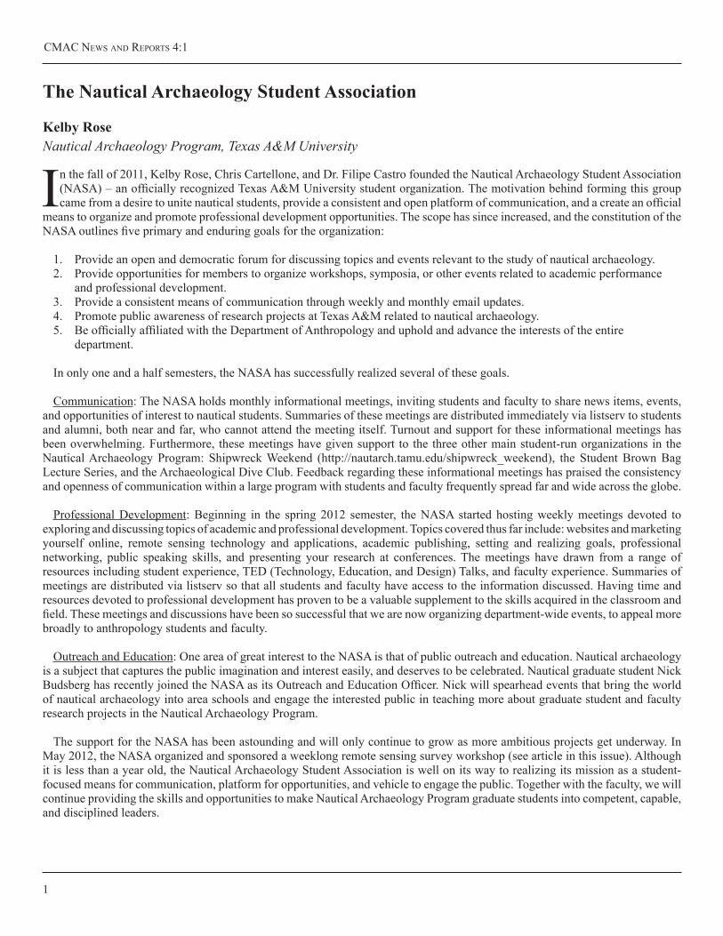
1 The Nautical Archaeology Student Association Kelby Rose
2 Survey Workshop 2012 Chris Cartellone and J. B. Pelletier
4 Pirate Hunting in Port Royal, Jamaica Chad M. Gulseth
7 Beginnings and Endings: The 2011 Field Season at Bajo de La Campana, Spain Laura White, with contributions from Staci Willis and Neil Puckett
9 TheGnalićProject:Post-MedievalTradeConnectionsandCargoShipConstruction David Ruff
13 ByzantineBilgeMudSpeaks Meko Kofahl 15 TheThreeDimensionalScanning,EvaluationandReconstructionof20thCenturyChineseRivercraftModels Douglas Inglis
On the Front Cover: Chad Gulseth holding an onion bottle while excavating in Port Royal, Jamaica. See article on page ?.
CMAC News ANd RepoRts 4:1
1
The Nautical Archaeology Student Association
Kelby RoseNautical Archaeology Program, Texas A&M University
In the fall of 2011, Kelby Rose, Chris Cartellone, and Dr. Filipe Castro founded the Nautical Archaeology Student Association (NASA) – an officially recognized Texas A&M University student organization. The motivation behind forming this group came from a desire to unite nautical students, provide a consistent and open platform of communication, and a create an official
means to organize and promote professional development opportunities. The scope has since increased, and the constitution of the NASA outlines five primary and enduring goals for the organization:
1. Provide an open and democratic forum for discussing topics and events relevant to the study of nautical archaeology.2. Provide opportunities for members to organize workshops, symposia, or other events related to academic performance
and professional development.3. Provide a consistent means of communication through weekly and monthly email updates.4. Promote public awareness of research projects at Texas A&M related to nautical archaeology.5. Be officially affiliated with the Department of Anthropology and uphold and advance the interests of the entire
department.
In only one and a half semesters, the NASA has successfully realized several of these goals.
Communication: The NASA holds monthly informational meetings, inviting students and faculty to share news items, events, and opportunities of interest to nautical students. Summaries of these meetings are distributed immediately via listserv to students and alumni, both near and far, who cannot attend the meeting itself. Turnout and support for these informational meetings has been overwhelming. Furthermore, these meetings have given support to the three other main student-run organizations in the Nautical Archaeology Program: Shipwreck Weekend (http://nautarch.tamu.edu/shipwreck_weekend), the Student Brown Bag Lecture Series, and the Archaeological Dive Club. Feedback regarding these informational meetings has praised the consistency and openness of communication within a large program with students and faculty frequently spread far and wide across the globe.
Professional Development: Beginning in the spring 2012 semester, the NASA started hosting weekly meetings devoted to exploring and discussing topics of academic and professional development. Topics covered thus far include: websites and marketing yourself online, remote sensing technology and applications, academic publishing, setting and realizing goals, professional networking, public speaking skills, and presenting your research at conferences. The meetings have drawn from a range of resources including student experience, TED (Technology, Education, and Design) Talks, and faculty experience. Summaries of meetings are distributed via listserv so that all students and faculty have access to the information discussed. Having time and resources devoted to professional development has proven to be a valuable supplement to the skills acquired in the classroom and field. These meetings and discussions have been so successful that we are now organizing department-wide events, to appeal more broadly to anthropology students and faculty.
Outreach and Education: One area of great interest to the NASA is that of public outreach and education. Nautical archaeology is a subject that captures the public imagination and interest easily, and deserves to be celebrated. Nautical graduate student Nick Budsberg has recently joined the NASA as its Outreach and Education Officer. Nick will spearhead events that bring the world of nautical archaeology into area schools and engage the interested public in teaching more about graduate student and faculty research projects in the Nautical Archaeology Program.
The support for the NASA has been astounding and will only continue to grow as more ambitious projects get underway. In May 2012, the NASA organized and sponsored a weeklong remote sensing survey workshop (see article in this issue). Although it is less than a year old, the Nautical Archaeology Student Association is well on its way to realizing its mission as a student-focused means for communication, platform for opportunities, and vehicle to engage the public. Together with the faculty, we will continue providing the skills and opportunities to make Nautical Archaeology Program graduate students into competent, capable, and disciplined leaders.
texAs A&M UNiveRsity
2
Survey Workshop 2012
J. B. Pelletier, Senior Nautical Archaeologist & Remote Sensing SpecialistURS Corporation
Chris CartelloneNautical Archaeology Program, Texas A&M University
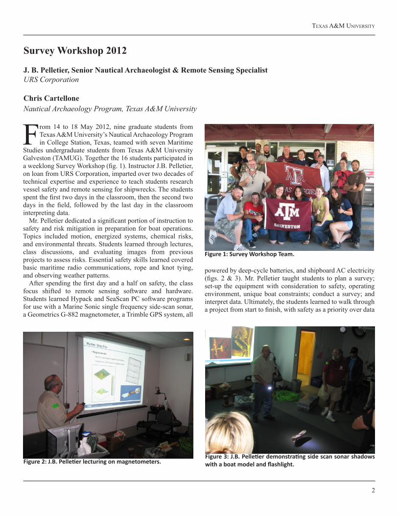
From 14 to 18 May 2012, nine graduate students from Texas A&M University’s Nautical Archaeology Program in College Station, Texas, teamed with seven Maritime
Studies undergraduate students from Texas A&M University Galveston (TAMUG). Together the 16 students participated in a weeklong Survey Workshop (fig. 1). Instructor J.B. Pelletier, on loan from URS Corporation, imparted over two decades of technical expertise and experience to teach students research vessel safety and remote sensing for shipwrecks. The students spent the first two days in the classroom, then the second two days in the field, followed by the last day in the classroom interpreting data.
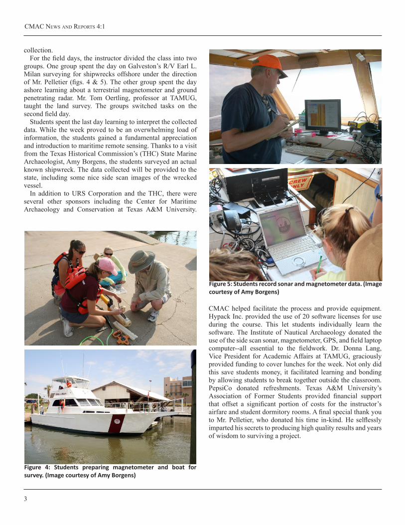
Mr. Pelletier dedicated a significant portion of instruction to safety and risk mitigation in preparation for boat operations. Topics included motion, energized systems, chemical risks, and environmental threats. Students learned through lectures, class discussions, and evaluating images from previous projects to assess risks. Essential safety skills learned covered basic maritime radio communications, rope and knot tying, and observing weather patterns.
After spending the first day and a half on safety, the class focus shifted to remote sensing software and hardware. Students learned Hypack and SeaScan PC software programs for use with a Marine Sonic single frequency side-scan sonar, a Geometrics G-882 magnetometer, a Trimble GPS system, all
powered by deep-cycle batteries, and shipboard AC electricity (figs. 2 & 3). Mr. Pelletier taught students to plan a survey; set-up the equipment with consideration to safety, operating environment, unique boat constraints; conduct a survey; and interpret data. Ultimately, the students learned to walk through a project from start to finish, with safety as a priority over data
Figure 1: Survey Workshop Team.
Figure 2: J.B. Pelletier lecturing on magnetometers.Figure 3: J.B. Pelletier demonstrating side scan sonar shadows with a boat model and flashlight.
CMAC News ANd RepoRts 4:1
3
collection.For the field days, the instructor divided the class into two
groups. One group spent the day on Galveston’s R/V Earl L. Milan surveying for shipwrecks offshore under the direction of Mr. Pelletier (figs. 4 & 5). The other group spent the day ashore learning about a terrestrial magnetometer and ground penetrating radar. Mr. Tom Oertling, professor at TAMUG, taught the land survey. The groups switched tasks on the second field day.
Students spent the last day learning to interpret the collected data. While the week proved to be an overwhelming load of information, the students gained a fundamental appreciation and introduction to maritime remote sensing. Thanks to a visit from the Texas Historical Commission’s (THC) State Marine Archaeologist, Amy Borgens, the students surveyed an actual known shipwreck. The data collected will be provided to the state, including some nice side scan images of the wrecked vessel.
In addition to URS Corporation and the THC, there were several other sponsors including the Center for Maritime Archaeology and Conservation at Texas A&M University.
CMAC helped facilitate the process and provide equipment. Hypack Inc. provided the use of 20 software licenses for use during the course. This let students individually learn the software. The Institute of Nautical Archaeology donated the use of the side scan sonar, magnetometer, GPS, and field laptop computer--all essential to the fieldwork. Dr. Donna Lang, Vice President for Academic Affairs at TAMUG, graciously provided funding to cover lunches for the week. Not only did this save students money, it facilitated learning and bonding by allowing students to break together outside the classroom. PepsiCo donated refreshments. Texas A&M University’s Association of Former Students provided financial support that offset a significant portion of costs for the instructor’s airfare and student dormitory rooms. A final special thank you to Mr. Pelletier, who donated his time in-kind. He selflessly imparted his secrets to producing high quality results and years of wisdom to surviving a project.
Figure 4: Students preparing magnetometer and boat for survey. (Image courtesy of Amy Borgens)
Figure 5: Students record sonar and magnetometer data. (Image courtesy of Amy Borgens)
texAs A&M UNiveRsity
4
In 1692, the buccaneer town of Port Royal became eternally infamous when a massive earthquake sank two-thirds of the city into the sea and killed over 3,000 people instantly. This
had been perceived as God’s retribution for the debauchery and wickedness of Port Royal’s inhabitants. Yet this horrific tragedy and disasters since have created a time capsule in which archaeologists have been able to study the material remains of a sunken city, shipwrecks, buildings, walls, and forts. Recently, myself and three archaeologists from the Texas A&M University’s Nautical Archaeology Program to spend 30 days in Port Royal investigating the legendary shipwrecks from the pirate Captain Bartholomew Roberts.
Sunday morning, 11 February 1722, a fierce storm pounded the seas off of Cape Lopez on Africa’s west coast. The pirate Captain Bartholomew Roberts was a gallant figure, dressed in a bright crimson damask waistcoat and breeches, a beaver hat with lace and a red feather, and a gold chain with a diamond cross around his neck. He carried two pairs of pistols at the end of silk slings over his shoulders and wielded a cutlass. Roberts prepared his men for the inevitable engagement with a 50 gun Royal Navy Man-of-War (Johnson 1998).
Captain Chaloner Ogle of HMS Swallow was confident. Six days prior, he defeated almost half of Roberts’ crew aboard the Great Ranger, without taking a single casualty and he was moving quickly to finish the job. The chase lasted until 2 o’clock in the afternoon when Swallow poured a broadside into the pirate flagship Royal Fortune and Roberts had his throat torn out by grapeshot.
With his gold and guns, he was wrapped in chains and dropped to Davy Jones’ Locker.
Of the pirates that survived to stand trial, 52 were hanged, 18 in chains, as a warning to other sailors, the punishment for piracy. Fifty-six others were acquitted while 20 were sentenced to seven years of servitude in the African mines (Atkins 1723).
After the executions were carried out, Ogle sailed across the Atlantic to Brazil, Barbados, and then Jamaica with Roberts’ three pirate ships he took as prizes. The Royal Fortune was Roberts’ flagship. Originally named Onslow, the pirates took this Royal African Company vessel off of Sesthos and pulled down some of her bulkheads to make her flush and fit for the purpose of roving and then they mounted her with 40 guns
(Johnson 1998). The Little Ranger was a French built light frigate they had seized earlier off the Senegal River. She had 16 cannon when they captured her but the pirates saw fit to arm her with 24. The Great Ranger was a fine French frigate taken at Whydah Road. With 32 guns she sailed incredibly well but was in the hands of the pirates for only a month before they were defeated. Roberts intended to clean and refit the Royal Fortune and Ranger and quit the Little Ranger before returning to the Caribbean to start his pirating spree again. The three ships made it to the Caribbean but under the command of the Royal Navy.
On 14 August 1722 Ogle sailed into Port Royal harbor with the three pirate prizes (ADM 51/945). Ogle had two weeks to sell off the cargo from these ships before a hurricane struck on 28 August. The Royal Fortune and the Little Ranger were blown
Pirate Hunting in Port Royal, Jamaica
ChadM.GulsethNautical Archaeology Program, Texas A&M University
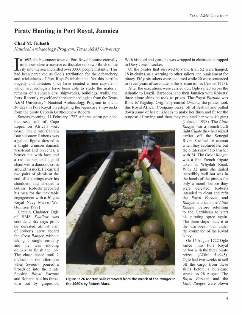
Figure 1: 26 Mortar Balls removed from the wreck of the Ranger in the 1960’s by Robert Marx.

CMAC News ANd RepoRts 4:1
5
across the harbor and lost on the rocks below Saltpann Hill (Ibid). The Great Ranger survived the hurricane but had all of her masts and rigging blown away. After the storm, Ogle’s vessel required significant repairs before they could make their voyage back home to England. In his efforts, the Great Ranger was salvaged until 5 October. Sometime after that but before Ogle left for London on 1 January 1723, the Great Ranger was sold in Port Royal. Ogle disclosed to the Admiralty that he received 5364..9..9 Sterling for the sale of the Great Ranger and other piratical effects (ADM 1/2242). Less than two years later, in 1724, the Ranger appears on a Royal Navy chart as a sunken navigational hazard in Port Royal Harbor. Until recently, this story and these wrecks have been overlooked.
Like a forgotten ghost, a small mountain in the center of a large depression. Only 45 feet (14 meters) of the pirate ship has been left reasonably undisturbed. The Great Ranger sank 30 years after the great earthquake and her remains actually rest on top of the sunken city along Fisher’s Row. A mound of rock and eight mortar balls are what remain of the ballast. A local diver named Emmanuel Blake told me that he helped Robert Marx remove 26 of these mortar balls from the wreck site and place them by the seawall in the late 1960’s. Recently, the Jamaican Coast Guard pulled the balls out of the sea, and the Jamaica National Heritage Trust has placed them in fresh water storage (fig. 1).
Guarded by spotted moral eels, stingrays and scorpion fish, 37 large, tightly spaced framing timbers peek out from the mound of rock and sand (fig. 2). On top of the ballast pile an
Figure 2: Chad Gulseth recording the framing timbers of the Ranger.
Figure 3: Raising a futtock timber from the Ranger.
texAs A&M UNiveRsity
6
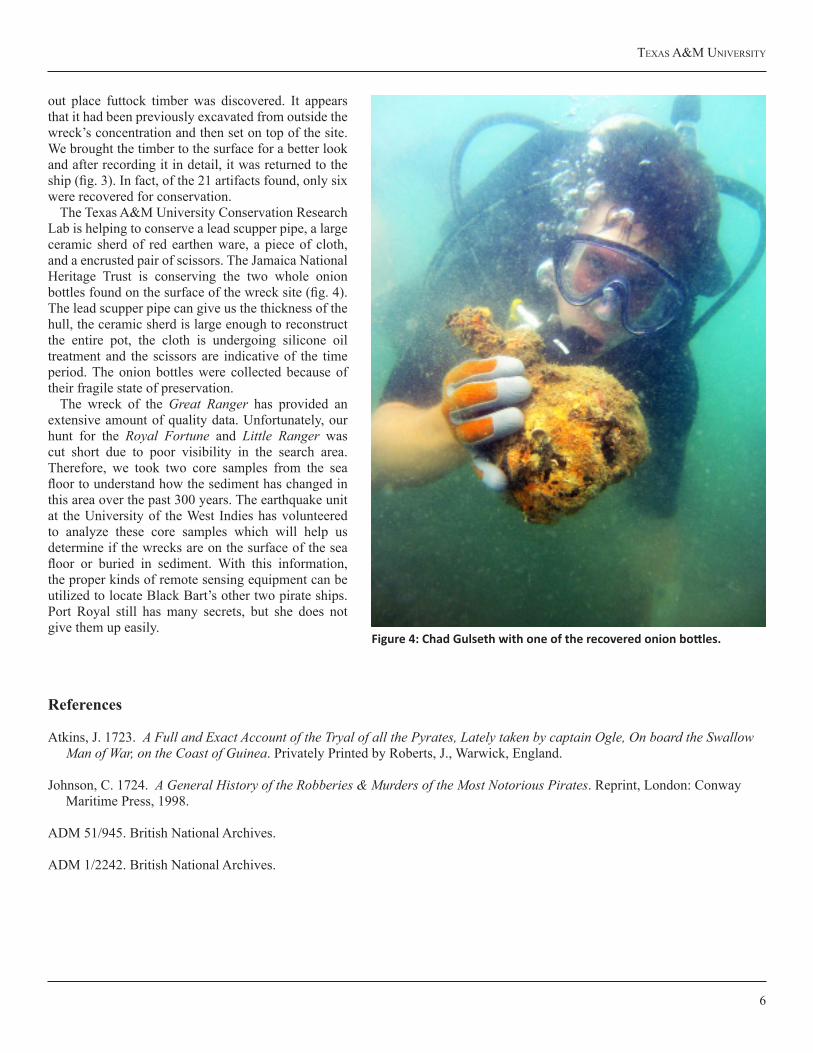
out place futtock timber was discovered. It appears that it had been previously excavated from outside the wreck’s concentration and then set on top of the site. We brought the timber to the surface for a better look and after recording it in detail, it was returned to the ship (fig. 3). In fact, of the 21 artifacts found, only six were recovered for conservation.
The Texas A&M University Conservation Research Lab is helping to conserve a lead scupper pipe, a large ceramic sherd of red earthen ware, a piece of cloth, and a encrusted pair of scissors. The Jamaica National Heritage Trust is conserving the two whole onion bottles found on the surface of the wreck site (fig. 4). The lead scupper pipe can give us the thickness of the hull, the ceramic sherd is large enough to reconstruct the entire pot, the cloth is undergoing silicone oil treatment and the scissors are indicative of the time period. The onion bottles were collected because of their fragile state of preservation.
The wreck of the Great Ranger has provided an extensive amount of quality data. Unfortunately, our hunt for the Royal Fortune and Little Ranger was cut short due to poor visibility in the search area. Therefore, we took two core samples from the sea floor to understand how the sediment has changed in this area over the past 300 years. The earthquake unit at the University of the West Indies has volunteered to analyze these core samples which will help us determine if the wrecks are on the surface of the sea floor or buried in sediment. With this information, the proper kinds of remote sensing equipment can be utilized to locate Black Bart’s other two pirate ships. Port Royal still has many secrets, but she does not give them up easily.
References
Atkins, J. 1723. A Full and Exact Account of the Tryal of all the Pyrates, Lately taken by captain Ogle, On board the SwallowMan of War, on the Coast of Guinea. Privately Printed by Roberts, J., Warwick, England.
Johnson, C. 1724. A General History of the Robberies & Murders of the Most Notorious Pirates. Reprint, London: ConwayMaritime Press, 1998.
ADM 51/945. British National Archives.
ADM 1/2242. British National Archives.
Figure 4: Chad Gulseth with one of the recovered onion bottles.
CMAC News ANd RepoRts 4:1
7
Beginnings and Endings: The 2011 Field Season at Bajo de La Campana, Spain
Laura White, with contributions from Staci Willis and Neil PuckettNautical Archaeology Program, Texas A&M University
It would be difficult to be studying in the Nautical Archaeology Program at Texas A&M University without hearing about the project at Bajo de la Campana. As
the first and only examination of a definitively Phoenician seagoing vessel, and furthermore, as one that has yielded such a remarkable profusion of Phoenician artifacts, it is a site of singular importance and one that is an exciting topic of discussion. Moreover, the project at the Bajo has served as a training ground for new underwater archaeologists from Texas A&M and from around the world. This year, three students from the Nautical Archaeology Program participated in the excavation: Neil Puckett returned for his second season, and Staci Willis and I both joined the team in Spain after completing our first year of graduate coursework. Furthermore, the core Spanish team was augmented with students from Belgium, Australia, and Turkey, all of whom received valuable experience in underwater fieldwork and excavation.
Details of previous seasons at Bajo de la Campana have appeared in earlier editions of the INA Quarterly and CMAC News and Reports, and a detailed account of this final season of excavation will be published in the upcoming INA Annual. As such, this article will focus upon on my experience as a nautical archaeologists beginning my career at the end of this particular archaeological campaign.
At the beginning of the 2011 season, Neil, Staci and I had no idea that we were participating in what would be the final season of the excavation. The previous year had yielded
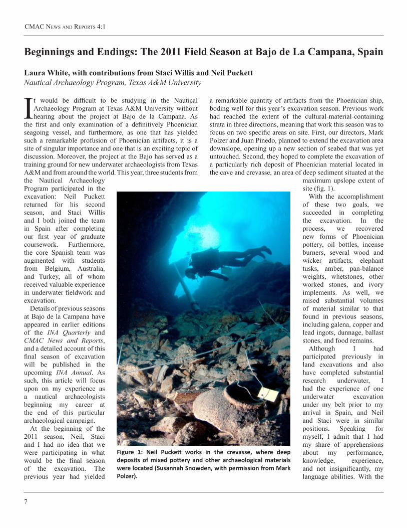
a remarkable quantity of artifacts from the Phoenician ship, boding well for this year’s excavation season. Previous work had reached the extent of the cultural-material-containing strata in three directions, meaning that work this season was to focus on two specific areas on site. First, our directors, Mark Polzer and Juan Pinedo, planned to extend the excavation area downslope, opening up a new section of seabed that was yet untouched. Second, they hoped to complete the excavation of a particularly rich deposit of Phoenician material located in the cave and crevasse, an area of deep sediment situated at the
maximum upslope extent of site (fig. 1).
With the accomplishment of these two goals, we succeeded in completing the excavation. In the process, we recovered new forms of Phoenician pottery, oil bottles, incense burners, several wood and wicker artifacts, elephant tusks, amber, pan-balance weights, whetstones, other worked stones, and ivory implements. As well, we raised substantial volumes of material similar to that found in previous seasons, including galena, copper and lead ingots, dunnage, ballast stones, and food remains.
Although I had participated previously in land excavations and also have completed substantial research underwater, I had the experience of one underwater excavation under my belt prior to my arrival in Spain, and Neil and Staci were in similar positions. Speaking for myself, I admit that I had my share of apprehensions about my performance, knowledge, experience, and not insignificantly, my language abilities. With the
Figure 1: Neil Puckett works in the crevasse, where deep deposits of mixed pottery and other archaeological materials were located (Susannah Snowden, with permission from Mark Polzer).
texAs A&M UNiveRsity
8
kind assistance of the Spanish director Juan and his assistant Annun, Staci and I arrived at the team’s base house at the end of May, and were joined a day later by Mark and soon thereafter by Neil. A week later the first Spanish team members began to arrive. There is nothing like a homemade Spanish midday meal, or comida, shared among new friends to allay one’s trepidations, and we’re eager and ready for the season of excavation to begin.
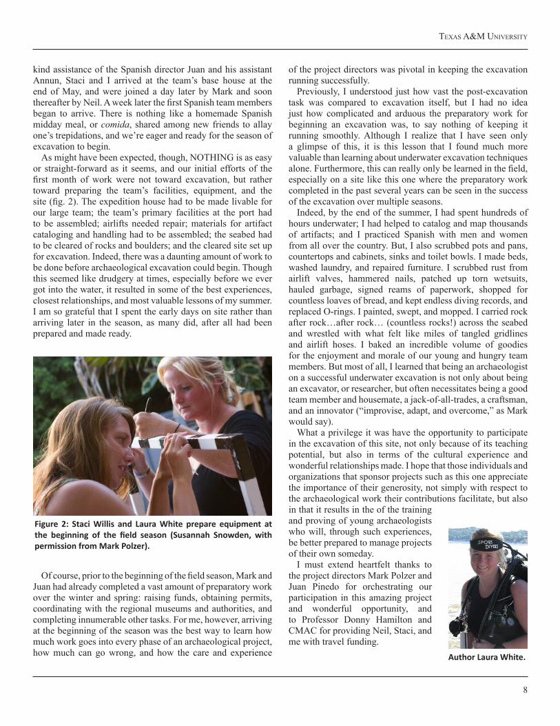
As might have been expected, though, NOTHING is as easy or straight-forward as it seems, and our initial efforts of the first month of work were not toward excavation, but rather toward preparing the team’s facilities, equipment, and the site (fig. 2). The expedition house had to be made livable for our large team; the team’s primary facilities at the port had to be assembled; airlifts needed repair; materials for artifact cataloging and handling had to be assembled; the seabed had to be cleared of rocks and boulders; and the cleared site set up for excavation. Indeed, there was a daunting amount of work to be done before archaeological excavation could begin. Though this seemed like drudgery at times, especially before we ever got into the water, it resulted in some of the best experiences, closest relationships, and most valuable lessons of my summer. I am so grateful that I spent the early days on site rather than arriving later in the season, as many did, after all had been prepared and made ready.
Of course, prior to the beginning of the field season, Mark and Juan had already completed a vast amount of preparatory work over the winter and spring: raising funds, obtaining permits, coordinating with the regional museums and authorities, and completing innumerable other tasks. For me, however, arriving at the beginning of the season was the best way to learn how much work goes into every phase of an archaeological project, how much can go wrong, and how the care and experience
of the project directors was pivotal in keeping the excavation running successfully.
Previously, I understood just how vast the post-excavation task was compared to excavation itself, but I had no idea just how complicated and arduous the preparatory work for beginning an excavation was, to say nothing of keeping it running smoothly. Although I realize that I have seen only a glimpse of this, it is this lesson that I found much more valuable than learning about underwater excavation techniques alone. Furthermore, this can really only be learned in the field, especially on a site like this one where the preparatory work completed in the past several years can be seen in the success of the excavation over multiple seasons.
Indeed, by the end of the summer, I had spent hundreds of hours underwater; I had helped to catalog and map thousands of artifacts; and I practiced Spanish with men and women from all over the country. But, I also scrubbed pots and pans, countertops and cabinets, sinks and toilet bowls. I made beds, washed laundry, and repaired furniture. I scrubbed rust from airlift valves, hammered nails, patched up torn wetsuits, hauled garbage, signed reams of paperwork, shopped for countless loaves of bread, and kept endless diving records, and replaced O-rings. I painted, swept, and mopped. I carried rock after rock…after rock… (countless rocks!) across the seabed and wrestled with what felt like miles of tangled gridlines and airlift hoses. I baked an incredible volume of goodies for the enjoyment and morale of our young and hungry team members. But most of all, I learned that being an archaeologist on a successful underwater excavation is not only about being an excavator, or researcher, but often necessitates being a good team member and housemate, a jack-of-all-trades, a craftsman, and an innovator (“improvise, adapt, and overcome,” as Mark would say).
What a privilege it was have the opportunity to participate in the excavation of this site, not only because of its teaching potential, but also in terms of the cultural experience and wonderful relationships made. I hope that those individuals and organizations that sponsor projects such as this one appreciate the importance of their generosity, not simply with respect to the archaeological work their contributions facilitate, but also in that it results in the of the training and proving of young archaeologists who will, through such experiences, be better prepared to manage projects of their own someday.
I must extend heartfelt thanks to the project directors Mark Polzer and Juan Pinedo for orchestrating our participation in this amazing project and wonderful opportunity, and to Professor Donny Hamilton and CMAC for providing Neil, Staci, and me with travel funding.
Figure 2: Staci Willis and Laura White prepare equipment at the beginning of the field season (Susannah Snowden, with permission from Mark Polzer).
Author Laura White.
CMAC News ANd RepoRts 4:1
9
During the 16th century, large ships were ordered and built to carry the material needs of a growing global commerce network, as merchants extended their interests west, to the New World, and east, to India, Malaysia, China and Japan. In the
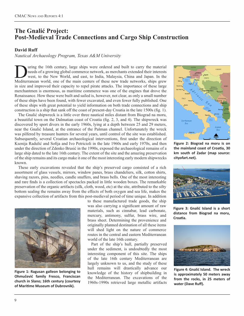
Mediterranean world, one of the main centers of these new trade networks, ships grew in size and improved their capacity to repel pirate attacks. The importance of these large merchantmen is enormous, as maritime commerce was one of the engines that drove the Renaissance. How these were built and sailed is, however, not clear, as only a small number of these ships have been found, with fewer excavated, and even fewer fully published. One of these ships with great potential to yield information on both trade connections and ship construction is a ship that sank off the coast of present-day Croatia in the late 1500s (fig. 1).
The Gnalić shipwreck is a little over three nautical miles distant from Biograd na moru, a beautiful town on the Dalmatian coast of Croatia (fig. 2, 3, and 4). The shipwreck was discovered by sport divers in the early 1960s, lying at a depth between 25 and 29 meters, near the Gnalić Island, at the entrance of the Pašman channel. Unfortunately the wreck was pilfered by treasure hunters for several years, until control of the site was established. Subsequently, several Croatian archaeological interventions, first under the direction of Ksenija Radulić and Sofija and Ivo Petricioli in the late 1960s and early 1970s, and then under the direction of Zdenko Brusić in the 1990s, exposed the archaeological remains of a large ship dated to the late 16th century. The extent of the site and the amazing preservation of the ship remains and its cargo make it one of the most interesting early modern shipwrecks known.
These early excavations revealed that the ship’s preserved cargo consisted of a rich assortment of glass vessels, mirrors, window panes, brass chandeliers, silk, cotton shirts, shaving razors, pins, needles, candle snuffers, and brass bells. One of the most interesting and rare finds is a collection of spectacles packed in little wooden boxes. The remarkable preservation of the organic artifacts (silk, cloth, wood, etc) at the site, attributed to the silty bottom sealing the remains away from the effects of both oxygen and sea life, makes the expansive collection of artifacts from this post-medieval period of time unique. In addition
to these manufactured trade goods, the ship was also carrying a significant amount of raw materials, such as cinnabar, lead carbonate, mercury, antimony, sulfur, brass wire, and brass sheet. Determining the provenience and originally planned destination of all these items will shed light on the nature of commerce routes in the central and eastern Mediterranean world of the late 16th century.
Part of the ship’s hull, partially preserved under the sediment, is undoubtedly the most interesting component of this site. The ships of the late 16th century Mediterranean are largely unknown to us, and the study of these hull remains will drastically advance our knowledge of the history of shipbuilding in the Mediterranean. The excavations of the 1960s-1990s retrieved large metallic artifacts
TheGnalićProject:Post-MedievalTradeConnectionsandCargoShipConstruction
David RuffNautical Archaeology Program, Texas A&M University
Figure 3: Gnalić Island is a short distance from Biograd na moru, Croatia.
Figure 4: Gnalić Island. The wreck is approximately 50 meters away from the rocks, in 25 meters of water (Dave Ruff).
Figure 1: Ragusan galleon belonging to Ohmučević family Fresco, Franciscan church in Slano; 16th century (courtesy of Maritime Museum of Dubrovnik).
Figure 2: Biograd na moru is on the mainland coast of Croatia, 30 km south of Zadar (map source: cityofart.net).
texAs A&M UNiveRsity
10
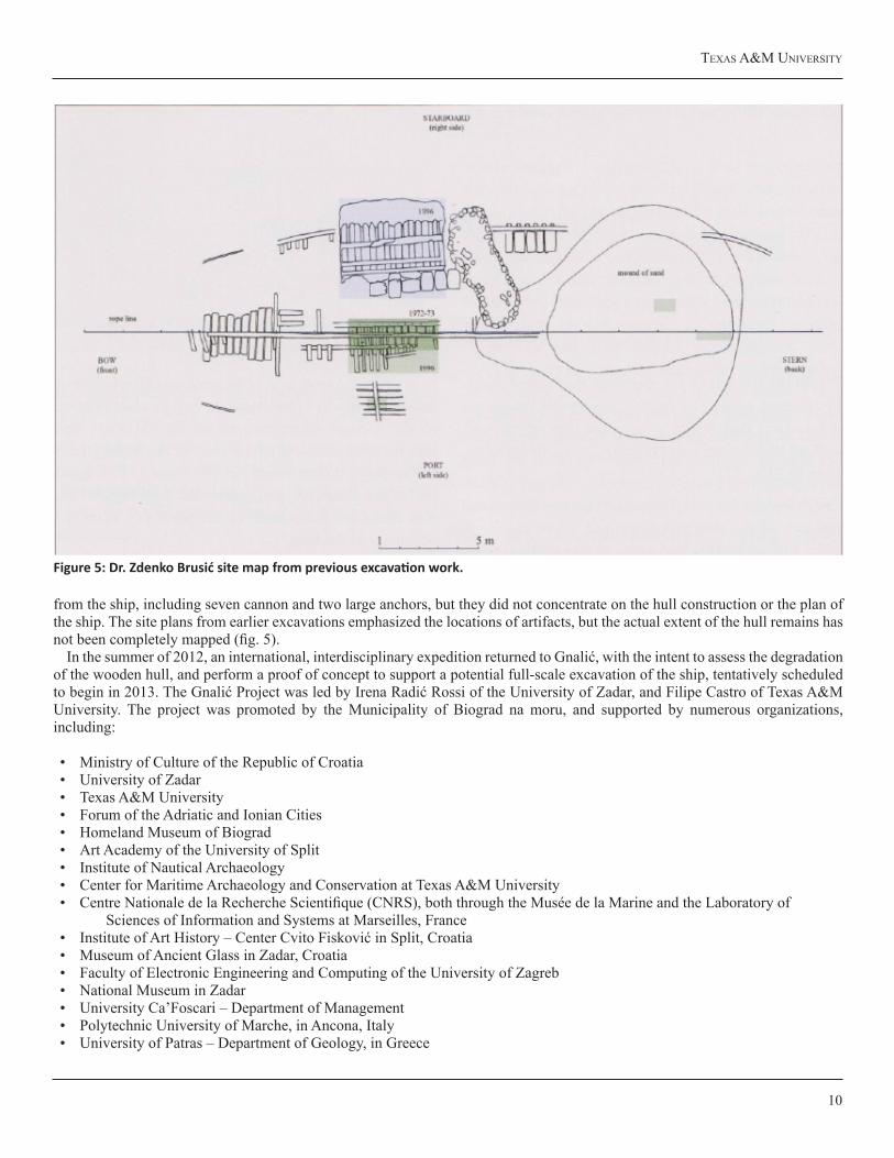
from the ship, including seven cannon and two large anchors, but they did not concentrate on the hull construction or the plan of the ship. The site plans from earlier excavations emphasized the locations of artifacts, but the actual extent of the hull remains has not been completely mapped (fig. 5).
In the summer of 2012, an international, interdisciplinary expedition returned to Gnalić, with the intent to assess the degradation of the wooden hull, and perform a proof of concept to support a potential full-scale excavation of the ship, tentatively scheduled to begin in 2013. The Gnalić Project was led by Irena Radić Rossi of the University of Zadar, and Filipe Castro of Texas A&M University. The project was promoted by the Municipality of Biograd na moru, and supported by numerous organizations, including:
• Ministry of Culture of the Republic of Croatia• University of Zadar • Texas A&M University• Forum of the Adriatic and Ionian Cities• Homeland Museum of Biograd• Art Academy of the University of Split• Institute of Nautical Archaeology• Center for Maritime Archaeology and Conservation at Texas A&M University• Centre Nationale de la Recherche Scientifique (CNRS), both through the Musée de la Marine and the Laboratory of Sciences of Information and Systems at Marseilles, France• Institute of Art History – Center Cvito Fisković in Split, Croatia• Museum of Ancient Glass in Zadar, Croatia• Faculty of Electronic Engineering and Computing of the University of Zagreb• National Museum in Zadar• University Ca’Foscari – Department of Management• Polytechnic University of Marche, in Ancona, Italy• University of Patras – Department of Geology, in Greece
Figure 5: Dr. Zdenko Brusić site map from previous excavation work.
CMAC News ANd RepoRts 4:1
11
Participants associated with the Center for Maritime Archaeology and Conservation included Dr. Filipe Castro, Peter Fix, Kotaro Yamafune, and Dave Ruff. The 2012 Gnalić excavation season included a total of 23 archaeologists/ divers from four countries (Croatia, the United States, Portugal, and Japan), three French photogrammetry experts, two Italian researchers, two Croatian conservators, one US conservator, and a German biologist. The field season began in June with a thorough review of previous excavation records and photographs, an evaluation of the existing artifact catalogue, and remeasurement of the two anchors previously found on the site, to facilitate computer modeling and weight calculations. Along with underwater activities, an important component of this project is the assessment of the existing artifact collection, in order to determine whether any item needs re-treatment or any conservation or cleaning operation. To support artifact preservation and control, a new database was established, populated with current artifacts, and prepared for entry of any artifacts which might be recovered during the 2012 season.
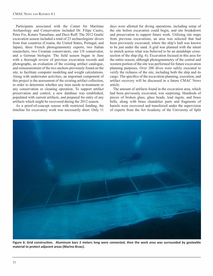
As a proof-of-concept season with restricted funding, the timeline for excavatory work was necessarily short. Only 11
days were allotted for diving operations, including setup of the site before excavation could begin, and site breakdown and preservation to support future work. Utilizing site maps from previous excavations, an area was selected that had been previously excavated, where the ship’s hull was known to be just under the sand. A grid was planned with the intent to stretch across what was believed to be an amidships cross-section of the ship (fig. 6). Excavation focused in this area for the entire season, although photogrammetry of the central and western portion of the site was performed for future excavation planning purposes. Over 200 dives were safely executed to verify the richness of the site, including both the ship and its cargo. The specifics of the excavation planning, execution, and artifact recovery will be discussed in a future CMAC News article.
The amount of artifacts found in the excavation area, which had been previously excavated, was surprising. Hundreds of pieces of broken glass, glass beads, lead ingots, and brass bells, along with brass chandelier parts and fragments of barrels were recovered and transferred under the supervision of experts from the Art Academy of the University of Split
Figure 6: Grid construction. Aluminum bars 2 meters long were connected, then the work area was surrounded by geotextile material to protect adjacent areas (Marino Brzac).
texAs A&M UNiveRsity
12
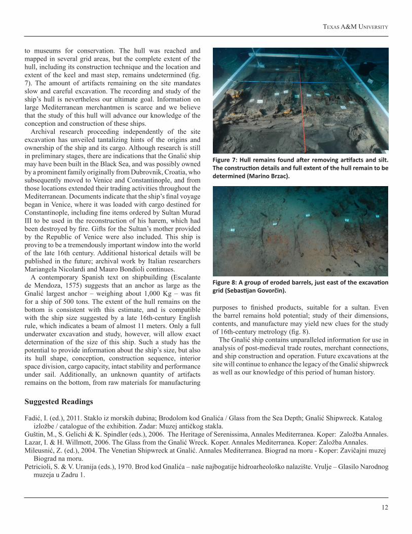
to museums for conservation. The hull was reached and mapped in several grid areas, but the complete extent of the hull, including its construction technique and the location and extent of the keel and mast step, remains undetermined (fig. 7). The amount of artifacts remaining on the site mandates slow and careful excavation. The recording and study of the ship’s hull is nevertheless our ultimate goal. Information on large Mediterranean merchantmen is scarce and we believe that the study of this hull will advance our knowledge of the conception and construction of these ships.
Archival research proceeding independently of the site excavation has unveiled tantalizing hints of the origins and ownership of the ship and its cargo. Although research is still in preliminary stages, there are indications that the Gnalić ship may have been built in the Black Sea, and was possibly owned by a prominent family originally from Dubrovnik, Croatia, who subsequently moved to Venice and Constantinople, and from those locations extended their trading activities throughout the Mediterranean. Documents indicate that the ship’s final voyage began in Venice, where it was loaded with cargo destined for Constantinople, including fine items ordered by Sultan Murad III to be used in the reconstruction of his harem, which had been destroyed by fire. Gifts for the Sultan’s mother provided by the Republic of Venice were also included. This ship is proving to be a tremendously important window into the world of the late 16th century. Additional historical details will be published in the future; archival work by Italian researchers Mariangela Nicolardi and Mauro Bondioli continues.
A contemporary Spanish text on shipbuilding (Escalante de Mendoza, 1575) suggests that an anchor as large as the Gnalić largest anchor – weighing about 1,000 Kg – was fit for a ship of 500 tons. The extent of the hull remains on the bottom is consistent with this estimate, and is compatible with the ship size suggested by a late 16th-century English rule, which indicates a beam of almost 11 meters. Only a full underwater excavation and study, however, will allow exact determination of the size of this ship. Such a study has the potential to provide information about the ship’s size, but also its hull shape, conception, construction sequence, interior space division, cargo capacity, intact stability and performance under sail. Additionally, an unknown quantity of artifacts remains on the bottom, from raw materials for manufacturing
purposes to finished products, suitable for a sultan. Even the barrel remains hold potential; study of their dimensions, contents, and manufacture may yield new clues for the study of 16th-century metrology (fig. 8).
The Gnalić ship contains unparalleled information for use in analysis of post-medieval trade routes, merchant connections, and ship construction and operation. Future excavations at the site will continue to enhance the legacy of the Gnalić shipwreck as well as our knowledge of this period of human history.
Figure 7: Hull remains found after removing artifacts and silt. The construction details and full extent of the hull remain to be determined (Marino Brzac).
Figure 8: A group of eroded barrels, just east of the excavation grid (Sebastijan Govorčin).
Suggested Readings
Fadić, I. (ed.), 2011. Staklo iz morskih dubina; Brodolom kod Gnalića / Glass from the Sea Depth; Gnalić Shipwreck. Katalogizložbe / catalogue of the exhibition. Zadar: Muzej antičkog stakla.
Guštin, M., S. Gelichi & K. Spindler (eds.), 2006. The Heritage of Serenissima, Annales Mediterranea. Koper: Založba Annales.Lazar, I. & H. Willmott, 2006. The Glass from the Gnalić Wreck. Koper. Annales Mediterranea. Koper: Založba Annales.Mileusnić, Z. (ed.), 2004. The Venetian Shipwreck at Gnalić. Annales Mediterranea. Biograd na moru - Koper: Zavičajni muzej
Biograd na moru.Petricioli, S. & V. Uranija (eds.), 1970. Brod kod Gnalića – naše najbogatije hidroarheološko nalazište. Vrulje – Glasilo Narodnog
muzeja u Zadru 1.
CMAC News ANd RepoRts 4:1
13
ByzantineBilgeMudSpeaks
MekoKofahlNautical Archaeology Program, Texas A&M University
Shipwreck botanical remains -- those pieces of vegetation found on a wreck as rope, caulking, or amphora contents – had gotten short shrift as archaeological resources until
rather recently. While still not commonplace on all excavations, it is becoming more routine to carefully sample shipwrecks and their surroundings for later botanical (and other) analysis. The pollen, phytoliths (silica-based plant crystals), and plant epidermal cells within these samples can tell us the source of a ship’s caulking reeds or sealing pitch, suggest its trade route, and can allude to shipboard diet, cargo, and sanitation.
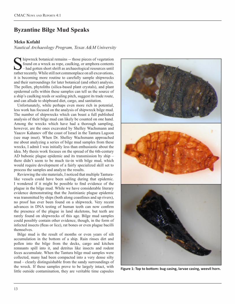
Unfortunately, while perhaps even more rich in potential, less work has focused on the analysis of shipwreck bilge mud. The number of shipwrecks which can boast a full published analysis of their bilge mud can likely be counted on one hand. Among the wrecks which have had a thorough sampling, however, are the ones excavated by Shelley Wachsmann and Yaacov Kahanov off the coast of Israel in the Tantura Lagoon (see map inset). When Dr. Shelley Wachsmann approached me about analyzing a series of bilge mud samples from these wrecks, I admit I was initially less than enthusiastic about the idea. My thesis work focuses on the spread of the 6th-century AD bubonic plague epidemic and its transmission by ship – there didn’t seem to be much tie-in with bilge mud, which would require development of a fairly specialized skill set to process the samples and analyze the results.
Reviewing the site materials, I noticed that multiple Tantura-like vessels could have been sailing during that epidemic. I wondered if it might be possible to find evidence of the plague in the bilge mud. While we have considerable literary evidence demonstrating that the Justinianic plague epidemic was transmitted by ships (both along coastlines and up rivers), no proof has ever been found on a shipwreck. Very recent advances in DNA testing of human teeth can now confirm the presence of the plague in land skeletons, but teeth are rarely found on shipwrecks of this age. Bilge mud samples could possibly contain other evidence, though, in the form of infected insects (fleas or lice), rat bones or even plague bacilli themselves.
Bilge mud is the result of months or even years of silt accumulation in the bottom of a ship. Rain rinses dirt and pollen into the bilge from the decks, cargo and kitchen remnants spill into it, and detritus like insects and rodent feces accumulate. When the Tantura bilge mud samples were collected, many had been compacted into a very dense silty mud – clearly distinguishable from the sandy surroundings of the wreck. If these samples prove to be largely intact, with little outside contamination, they are veritable time capsules Figure 1: Top to bottom: bug casing, larvae casing, weevil horn.
texAs A&M UNiveRsity
14
of life on board ship.While I can only tentatively report results for a single (albeit
very interesting) sample from Tantura A, a shipwreck dated from the late 5th to the early 6th centuries AD, the preliminary findings are very exciting. In addition to the insect parts pictured, there are a number of seeds and a good deal of pollen present. The black ‘horn’ is likely from some sort of weevil – as yet unidentified – and the other two may represent larvae of some sort (fig. 1). The quartz-like grains on the darker insect
body sample are individual grains of sand; these are very small insects. Finding such tiny examples makes me hopeful that shipboard fleas, if they were caught in the bilge, could still be found.
Drs. Wachsmann and Kahanov are working aggressively to publish the final report on the Tantura site, where I hope we will be able to include a full report on the contents of the vessels’ bilge mud and other botanical materials.
Suggested Readings
Gorham, L. D. 2000. “The Archaeobotany of the Bozburun Shipwreck.” Unpublished Dissertation. Texas A&M University,College Station.
Gorham, L. D. and V. M. Bryant. 2001. “Pollen, phytoliths, and other microscopic plant remains in underwater archaeology.”IJNA 30.2: 282-298.
Jacobsen, M. et al. 1998. “Preliminary Pollen Analysis of Terebinth Resin from a Bronze Age Mediterranean Shipwreck.”In: Bryant, V. M. and Wrenn, J. H. (eds.), New Developments in Palynomorph Sampling, Extraction, and Analysis; AmericanAssociation of Stratigraphic Palynologists Foundation, Contributions Series Number 33: 75-82.
Jones, J. G. et al. 1998. “Pollen Analysis of Ceramic Containers from a Late Iron Age II or Persian Period Shipwreck Site nearHaifa, Israel”. In: Bryant, V. M. and Wrenn, J. H. (eds.), New Developments in Palynomorph Sampling, Extraction, andAnalysis; American Association of Stratigraphic Palynologists Foundation, Contributions Series Number 33: 61-74.
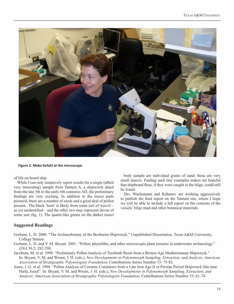
Figure 2: Meko Kofahl at the microscope
CMAC News ANd RepoRts 4:1
15
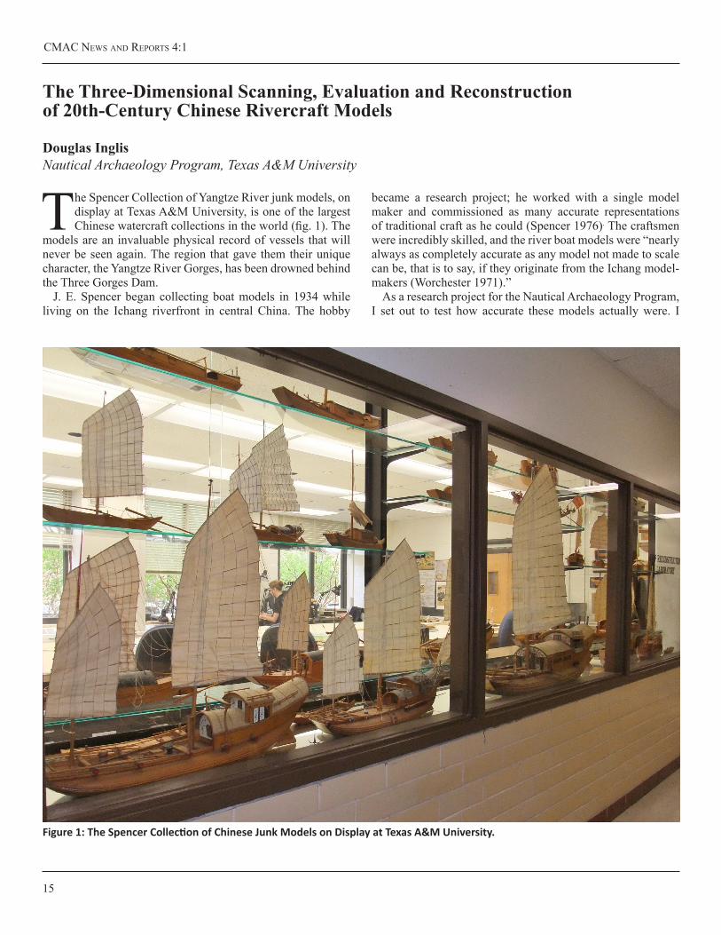
The Spencer Collection of Yangtze River junk models, on display at Texas A&M University, is one of the largest Chinese watercraft collections in the world (fig. 1). The
models are an invaluable physical record of vessels that will never be seen again. The region that gave them their unique character, the Yangtze River Gorges, has been drowned behind the Three Gorges Dam.
J. E. Spencer began collecting boat models in 1934 while living on the Ichang riverfront in central China. The hobby
became a research project; he worked with a single model maker and commissioned as many accurate representations of traditional craft as he could (Spencer 1976). The craftsmen were incredibly skilled, and the river boat models were “nearly always as completely accurate as any model not made to scale can be, that is to say, if they originate from the Ichang model-makers (Worchester 1971).”
As a research project for the Nautical Archaeology Program, I set out to test how accurate these models actually were. I
TheThree-DimensionalScanning,EvaluationandReconstructionof20th-CenturyChineseRivercraftModels
Douglas InglisNautical Archaeology Program, Texas A&M University
Figure 1: The Spencer Collection of Chinese Junk Models on Display at Texas A&M University.

texAs A&M UNiveRsity
16
elected to study two Shou-K’ou Ma-Yang-Tzu models from the large collection (fig. 2). Ma-Yang-Tzu was a broad class of freight carriers that were designed to carry very heavy cargoes and to survive treacherous rapids (Audemard 1963). The type spawned many variants, some of which were all but “indistinguishable save to the eye of a junkman (Worchester 1971).” The “Shou-K’ou” variant means “Closed Mouth,” a reference to the vessels’ extreme tumblehome. The barrel shaped hull could take an awful beating from submerged rocks. The inward curving shape also narrowed and elevated the deck, providing increased protection for water sensitive cargoes, such as cotton, grain and wood oil (Spencer 1976).
Shou-K’ou Ma-Yang-Tsu, were specifically designed to
navigate the treacherous stretch known as the Gorges. One in ten vessels attempting to pass through the vicious rapids was lost. Worchester notes, “had the position of these rocks and other hidden dangers been selected by an expert wrecker, they could not have been placed in a more diabolically clever manner (Worchester 1940).” The vessels had to be hauled over the rapids by gangs of up to 400 men who would lash themselves to heavy bamboo hawsers. While the upriver passage could take eight weeks or more, the downriver passage took only between five to twelve days. With their masts down and lashed to their sides, the vessels crashed headlong through the dangerous rapids under the guidance of skilled local pilots (Worchester 1940).
Models of Shou-K’ou Ma-Yang-Tzu were popular amongst tourists, and more models of this type of vessel were made than any other. Not all models are created equal; close examination reveals numerous technical differences between the two that I studied. We can compare the Spencer models to three important sources of information. Twentieth-century travelers in central China left both written and photographic accounts of the vessels. However, the records of G. R. G. Worchester, a British Customs Inspector, are the most invaluable source of data. Worchester took the time to draft and document hundreds of river vessels. Because of these resources, it is probable that more data is available on Yangtze rivercraft than any other group of Chinese vessels.
I used a FARO Arm to create three-dimensional scans of the Shou-K’ou Ma-Yang-Tzu models (fig. 3). This allowed me to directly compare their hull form to Worchester’s construction plans. The process was not straight forward. The reflective surfaces of the models would not record correctly, even after we dusted them with baby power. It was possible to fix these digital data “holes” during post processing, however, and scanning produced a digital model with sub millimeter accuracy.
Figure 2: Shou-K’ou Ma-Yang-Tzu Model #21.
Figure 3: Raw data from the FARO arm scan. White holes represent reflective areas where data could not be gathered. GeoMagic Studio was to digitally patch the holes during post-processing

CMAC News ANd RepoRts 4:1
17
Thorough examination of the Spencer models reveals that neither was made to scale. Based on similar features, the dimensions of Model #21 are much more accurate, and I estimate that it is fairly accurate representation of a 30 m vessel. The second model, #22, was acquired early in the collecting process. It was decorated with an inauthentic floral design to attract buyers who often overlooked the plain riverboat models in favor of brightly decorated sea going vessels (Spencer 1976). It has a disproportionate shape, and numerous technical inaccuracies.
Model #21 was acquired after Spencer began ordering custom replica vessels. It has numerous nuances that speak to its authenticity of design. Unlike Model #22, a) the sails are properly roped to the boom and yard, b) the main mast is fished from two spars, (this is visible in contemporary photographs),
c) there is a mast ring for draining water and supporting the boom, d) the slingpoint for the main yard is authentically replicated, and e) the mainsail sheets are run correctly though miniature sheaves in long wooden posts at the stern.
Because Model #21 had so many authentic details, I decided to test whether its sail plan was accurate enough to serve as a template for reconstructing a hypothetical Yangtze River batten lugsail rig. These sails are drastically different from western rigs, with a distinctive fan shape, close-set battens, complex sheeting system and lack of standing rigging. Sails were laced to a series of horizontal battens that distributed sail pressure evenly to the mast, and allowed the vessel to point closer to the wind (Audemard 1963, Worchester 1971, and Hasler and McLeod 1988). This is particularly important in narrow water ways like the Gorges, which required short tacks and a
Figure 4: Reconstructed Shou-K’ou Ma-Yang-Tzu.
texAs A&M UNiveRsity
18
References
Audemard, L. 1963. Construction De La Jonque, Vol. 2, Haut Yang Tse Kiang. Rotterdam, Museum voor Land- en Volkenkunde en Maritiem Musuem “Prins Hendrik.”
1963. Les Jonques Chinoises, Vol. 5, Haut Yang Tse Kiang. Rotterdam, Museum voor Land- en Volkenkunde en Maritiem Musuem “Prins Hendrik.”
Hasler, H. G. and J. K. McLeod. 1988. Practical Junk Rig: Design Aerodynamics and Handling. London: Aldard Coles.
Spencer, J. E. 1976. Junks of Central China: The Spencer Collection of Models at Texas A&M University. College Station: Texas A&M Press.
Worchester, G. R. G. 1971. The Junks and Sampans of the Yangtze. Annapolis: Naval Institute Press.
1940. Junks and Sampans of the Upper Yangtze. Shanghai: Kelly & Walsh.
great deal of windward work (Worchester 1971). Batten sails reef and furl efficiently; they tend to fold and layer as the sail collapses. Battens also create a rigid framework, and a sail full of holes still pulls well (Audemard 1963, Worchester 1971, and Hasler and McLeod 1988). Chinese lugsails were controlled with an ingenious network of sheets, arranged so that the sail would uniformly adjust itself to the wind. This complex system allowed the sail to swing in a full arc, provided fine control over the sail’s shape and prevented twisting.
The Chinese lug sail is an ingenious machine. Because it is so complex, small flaws in the design can have disastrous results. Although Model #21 has a cosmetically accurate sail plan, a number of adjustments were needed to make it a working rig. I based my reconstruction on ethnographic records, junk plans, historic photographs and modern sailing manuals. The changes included increasing the number of battens and sheet spans, altering the batten angle to prevent them from tangling in the sheeting system, adding running toppling lifts, mast lifts and tack parrels, and slightly altering the sail shape. The rig
reconstruction is true to the model, as designed, in as many places as possible (fig. 4). Hopefully the alterations are also true to the vessel’s function, lugsail mechanics and Chinese traditional rigging methods.
The Spencer Yangtze River junk models are an important source of three-dimensional data. Despite being simplified, the models were made by a skilled craftsman with firsthand knowledge of the vessels. Testing three-dimensional scans captured with a FARO Arm against detailed illustrations by G. R. G. Worchester reveals that the models are largely accurate to their traditional types. Of the two models analyzed, the one that Spencer acquired later (Model #21) is much more accurate, both in hull form and rigging. If used with caution, the Spencer Collection can be an unparalleled record of historic Chinese ship construction and design. It includes models of unique ship types, not seen in other sources. The collection is worthy of extensive research, and is a priceless addition to the Nautical Archaeology Program at Texas A&M University.
CMAC News ANd RepoRts 4:1
19
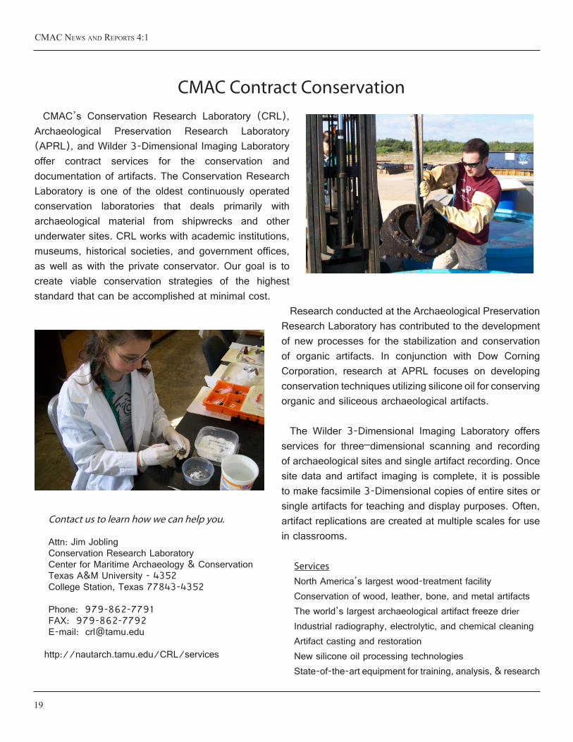
CMAC Contract Conservation CMAC’s Conservation Research Laboratory (CRL),
Archaeological Preservation Research Laboratory (APRL), and Wilder 3-Dimensional Imaging Laboratory offer contract services for the conservation and documentation of artifacts. The Conservation Research Laboratory is one of the oldest continuously operated conservation laboratories that deals primarily with archaeological material from shipwrecks and other underwater sites. CRL works with academic institutions, museums, historical societies, and government offices, as well as with the private conservator. Our goal is to create viable conservation strategies of the highest standard that can be accomplished at minimal cost.
Research conducted at the Archaeological Preservation Research Laboratory has contributed to the development of new processes for the stabilization and conservation of organic artifacts. In conjunction with Dow Corning Corporation, research at APRL focuses on developing conservation techniques utilizing silicone oil for conserving organic and siliceous archaeological artifacts.
The Wilder 3-Dimensional Imaging Laboratory offers services for three–dimensional scanning and recording of archaeological sites and single artifact recording. Once site data and artifact imaging is complete, it is possible to make facsimile 3-Dimensional copies of entire sites or single artifacts for teaching and display purposes. Often, artifact replications are created at multiple scales for use in classrooms.
ServicesNorth America’s largest wood-treatment facilityConservation of wood, leather, bone, and metal artifactsThe world’s largest archaeological artifact freeze drierIndustrial radiography, electrolytic, and chemical cleaningArtifact casting and restorationNew silicone oil processing technologiesState-of-the-art equipment for training, analysis, & research
Contact us to learn how we can help you.
Attn: Jim JoblingConservation Research LaboratoryCenter for Maritime Archaeology & ConservationTexas A&M University - 4352College Station, Texas 77843-4352
Phone: 979-862-7791 FAX: 979-862-7792E-mail: [email protected]
http://nautarch.tamu.edu/CRL/services
texAs A&M UNiveRsity
20
http://nautarch.tamu.edu/ Over the past two decades Texas A&M University (TAMU), through its affiliation with the Institute of
Nautical Archaeology (INA), the joint excavations of significant shipwrecks with INA, and the establishment of the Nautical Archaeology Program (NAP) in the Department of Anthropology, has become recognized as having one of the best nautical archaeology academic and research programs in the world. Over this same period, the conservation laboratories that were part of NAP became very innovative and are acknowledged as being leaders in this field of conservation. In order to capitalize and build on this recognition, a Center for Maritime Archaeology and Conservation (CMAC) was created by the Texas A&M University Board of Regents in May 2005 as the best means by which the goals and mission of nautical archaeology at TAMU can be realized.
The mission of CMAC is simple. CMAC, as a research center at TAMU, and through its affiliation with INA and the Department of Oceanography, will continue to keep TAMU in the forefront of nautical, maritime, and underwater archaeology research. It will continue to build on its expertise in artifact conservation, advance underwater mapping technology, and build on the reputation it now has in these research areas. More simply put, CMAC’s mission is to form research alliances such as the one we have with the INA in order to continue to be in the forefront of maritime archaeology research and be an active partner in one of the best academic programs in nautical archaeology in the world. To accomplish these ideals, CMAC has incorporated eight NAP laboratories specializing in various research areas and aspects of nautical archaeology.
By concentrating on these objectives, CMAC will accomplish this multifaceted mission, but we need
your support. Contact us today to learn how you can contribute to our research efforts in exploring, documenting, conserving, and studying underwater archaeological sites, and educating the next generation of maritime archaeologists.
Attn: Kevin Crisman Center for Maritime Archaeology & Conservation Anthropology Building 107 Texas A&M University College Station, TX 77843-4352 United States
CMAC News & Reports Summer 2014
Vol. 4 No.1
Center for MaritiMe arChaeology & Conservation • nautiCal arChaeology PrograM