Embed Size (px)
Citation preview

BurghfieldDrainageStrategy
Stage 1 - Initialise/Prepare
Britain’s first sewerage systems were constructed 150 years ago in the Victorian era, and have served us well for generations. The sewer network Thames Water operates today has been much improved and vastly extended over the years; yet it remains under increasing pressure.
Everyday our network manages the demands of one of the world’s busiest and most densely populated capital cities, and its urbanised surrounding areas; together with the equally complex
challenges arising in our predominantly rural catchments in the Thames Valley, Surrey and Kent.
A number of factors including population growth, less frequent but heavier rainfall, the urbanisation of green spaces and changes in agricultural land practices, and utilised machinery, occasionally overwhelm our sewer network. The result can be unwanted sewer flooding for customers and our neighbouring natural environments.
Introduction
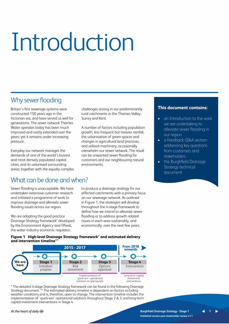
Why sewer flooding
What can be done and when?Sewer flooding is unacceptable. We have undertaken extensive customer research and initiated a programme of work to improve drainage and alleviate sewer flooding issues across our region.
We are adopting the good practice Drainage Strategy framework* developed by the Environment Agency and Ofwat, the water industry economic regulator,
to produce a drainage strategy for our affected catchments with a primary focus on our sewerage network. As outlined in Figure 1, the strategies will develop throughout the 4-stage framework to define how we intend to alleviate sewer flooding or to address growth related issues in each area sustainably, and economically, over the next few years.
This document contains:
• anIntroductiontothework weareundertakingto alleviatesewerfloodingin ourregion• aFeedback:Q&Asection addressingkeyquestions fromcustomersand stakeholders• theBurghfieldDrainage Strategytechnical document.
Burghfield Drainage Strategy - Stage 1 1
Published version post stakeholder review v1.1
2015 - 2017
Stage 1We arehere Initialise/
prepare
Stage 2Risk
assesment
Stage 3Options
appraisal
Stage 4
From 2018onwards
Intervention
Implementation of 'quick-win' operational solutions as appropriate
Long-term capital investment
interventions
Figure 1 High-level Drainage Strategy framework* and estimated delivery and intervention timeline**
* The detailed 4-stage Drainage Strategy framework can be found in the following Drainage Strategy document. ** The estimated delivery timeline is dependent on factors including weather conditions and is, therefore, open to change. The intervention timeline includes the implementation of ‘quick-win’ operational solutions throughout Stage 2 & 3, and long-term capital investment interventions in Stage 4.

ResponsibleDrainagePartners
Land andRiparianOwners
Council/Highways
England
ThamesWater
Customers
Council/Lead Local FloodAuthority
EnvironmentAgency
Who will resolve the sewer flooding?
There are a number of stakeholders who, like us, have important drainage responsibilities and therefore, play an essential role in resolving sewer flooding in our region. These stakeholders include customers, private land owners and the Environment Agency; to name but a few. We are seeking to work in partnership with all stakeholders to ensure that together, we implement and maintain the most effective and sustainable drainage strategies.
Just as our responsibilities to improve drainage and alleviate sewer flooding focus on removing and treating wastewater; other stakeholders’ responsibilities include managing local flood risk on riverbanks, ground water,
land and highways, utilising appropriate agricultural practices and maintaining private drains.
We take full responsibility for resolving all drainage and sewer flooding issues that fall within our remit. If the causes of sewer flooding sit outside of this, we will support the responsible stakeholder to resolve the issue and to reduce the impact on customers.
Figure 2 provides a high-level view of the stakeholders responsible for drainage in each catchment area, more detail regarding responsibilities can be found in Section 1 of the following Drainage Strategy document.
Figure 2 Partners with Drainage Responsibilities
Burghfield Drainage Strategy - Stage 1 2
Published version post stakeholder review v1.1

• Continue to consult with customers during this stage and every stage, through meetings, communications and surveys. We have gained important customer feedback during this first stage, which we are using to shape our activities
• Publish strategy documents for comment and contribution, throughout this framework process.
• Continue to establish partnership working with the regional drainage stakeholders, and agree ongoing consultation processes.
• Define catchment flooding uncertainties
• Prepare flooding risk data • Undertake ongoing repair work to our
sewer network, as the strategy develops and our investigations identify reparation work linked to drainage and flooding issues.
Next steps
Over the coming months we will undertake the following activities as this drainage strategy develops:
Burghfield Drainage Strategy - Stage 1 3
Published version post stakeholder review v1.1
Customer Focus Actions
2015 - 2017
PartnershipActions
Other KeyActions
Wewillregularlyconsult with customers and stakeholders, update and republishthisdocumentthroughoutthis4-stageframeworkprocess.

We are committed to listening to, consulting and collaborating with customers and stakeholders on our sewerage network activities and plans. We have addressed key feedback and questions raised by customers and stakeholders in the Burghfield catchment, and customers affected by flooding throughout the region, in this Feedback Q&A section. As far as possible, and as is relevant to Stage 1 in the framework process, we have incorporated feedback from customers and stakeholders into our network strategy development. More detail can be found throughout the following Drainage Strategy document.
Feedback: Q&A Your questions answered
Q1 Will undertaking this Drainage Strategy framework process defer essential work in our area?
Q2 What drainage actions are you undertaking in our area, and when will they be happening?
Answer
Answer
It is essential for us to complete this drainage strategy process, which has been developed and recommended by the water industry economic regulator Ofwat, and the Environment Agency. This will enable us to better understand the root cause of the sewer flooding issues affecting the catchment, before any major investment can be considered. However, we may carry out some repair works as this strategy develops, in the event that our investigations identify faults or problems with the sewerage network that are highly likely to have caused flooding, as outlined
in Section 7 of the Drainage Strategy document. Our previous investigations have identified some sources of inflow, such as the misconnection of surface water to foul sewers. However, as stated in the following strategy, we are not yet able to say how much this impacts on flooding and will update this as our plan develops through Stage 2 to Stage 3 –Option Appraisal. Therefore, this more detailed approach is required to ensure that the most effective and sustainable drainage strategies are implemented in the Burghfield catchment.
As stated above, we are developing our plan for this area and will provide further details as our plan develops through Stage 2 to Stage 3 – Option Appraisal. The following drainage actions have already been undertaken, or are underway, in the Burghfield catchment:
Actions completed include: (For more information please see Table 2)
1 Manhole survey2 CCTV survey of our sewer network3 Manhole cover replacement4 Root cutting5 Sewer rehabilitation6 Installation of sewer depth monitors 7 Flooding clean-up.
Actions underway or planned include: (For more information please see Table 4)
1. Stakeholder engagement activities2. Permanent monitoring of Pumping
station3. Customer surveys4. Sewer and manhole surveys5. Connectivity surveys6. Innovative solution analysis.
Burghfield Drainage Strategy - Stage 1 4
Published version post stakeholder review v1.1
Wearecommittedtolistening to,consulting and collaborating withcustomersandstakeholdersonourseweragenetworkactivitiesandplans.

The sewage treatment works has had a number of upgrades to meet changing performance criteria. The most recent major scheme it received was undertaken in 2005. Currently no further upgrades
are planned as the capacities of the works have been assessed to be adequate under normal design flow conditions, for the current population.
Q3 Are you renovating the sewers in our area?
Q4 What are the improvement plans for Burghfield’s sewage treatment works to manage capacity?
Q5 How are you planning for future development in the catchment?
Answer
Answer
Answer
We will renovate sewers which have been damaged, either as they have aged or through other streetworks activities. As outlined in Table 2 above and Section 4.3 below, sewer rehabilitation has been undertaken across the network within the Burghfield catchment in recent years to try and limit the inflows. Other sewer maintenance activities have also been
completed to address sewer misuse and fats, oils and grease build-up.
We will continue to target and repair localised sewer defects identified through our investigations as contributing to, or causing, drainage and flooding issues in the catchment throughout this 4-stage framework process.
As per Section 5.3 in the following Drainage Strategy document, we will continue to closely monitor development applications in the catchment and assess the impact that they may have on the capacity of our operations in the future. Our existing sewage treatment works currently has the capacity to manage all of the development applications submitted and projected for the catchment, as outlined in the West
Berkshire Council Development Plan. We will continue to work with all involved stakeholders through our stakeholder engagement activities, to monitor local plans and planning applications and to incorporate current and projected developments into our business planning cycle, to ensure that our service is maintained for customers throughout the catchment’s development.
Burghfield Drainage Strategy - Stage 1 5
Published version post stakeholder review v1.1

In Section 1of the following Drainage Strategy document, we outline the other stakeholders who, like us, have important drainage responsibilities and therefore, play an essential role in resolving sewer flooding issues in this catchment area. As Highways maintenance activities and agricultural land maintenance practices sit outside of our remit we will work with the responsible stakeholders, to highlight these issues where this is found to have a major influence and impact on our sewerage network.
We will continue to work closely with the Council and Highways England to understand the extent to which flood waters may be escaping from highway or land drainage systems; and impacting the foul sewer network. An update on this issue will be shared with customers and featured in the later stages of this Drainage Strategy document.
Ensuring that our drainage strategies fully meet the requirements of an Infiltration Reduction Plan, as set out in the Environment Agency’s Regulatory Position Statement, is a fundamental consideration in their development. Therefore, to maintain our service to customers during future wet weather events, if we need to discharge to watercourses through temporary overflows, a dedicated section will be included in each affected strategy, providing details of their location and intended use. This section will be included and /or revised when each strategy is updated.
In the event that temporary overflows are required, as stated above, we will describe their location and the circumstances under which we would use them. Together with plans to reduce infiltration, this drainage strategy would then fully meet the requirements of an Infiltration Reduction Plan.
Q6 Are you working with the Highway Authority to resolve blocked gullies, sewers and ditches, and with landowners to reduce field run-off, as both affect drainage and our sewers?
Q7 Is an Infiltration Reduction Plan (IRP), required for this catchment?
Answer
Answer
Burghfield Drainage Strategy - Stage 1 6
Published version post stakeholder review v1.1

Q10 Are growth and urban creep minor factors in these rural catchments?
AnswerWe are aware of number of potential new developments in the Burghfield catchment and, the urban creep rate for the catchment is above average for the Thames Operational Area. Relatively small population increases in these smaller rural catchments can be influential on sewer flows, hence the need for us to closely monitor planning applications. Similarly urban creep, and in particular misconnection of surface water and
change of land use, can have a significant impact on sewer flooding; particularly when permeable areas such as grass are replaced with hard-standings and driveways.
More growth and urban creep information can be found in Section 5.1 of the following Drainage Strategy document.
Burghfield Drainage Strategy - Stage 1 7
Published version post stakeholder review v1.1
Q9 How are you ensuring that our local pumping stations are operating effectively?
Q8 Why are costs a consideration within your Wastewater outcomes?
Answer
Answer
The Burghfield sewerage catchment incorporates 11 foul water pumping stations. The stations are supported by 24 hour diagnostic monitoring. This enables us to tightly control their operation through a flow of real-time information. Based on this performance data we can respond quickly through site visits by our engineers, and both project and rectify potential issues before they occur.
As we move through this 4-stage framework process and further develop our Drainage Strategy for this catchment, we will review the operational control options of these stations, particularly during wet weather, carefully avoiding increasing the risk of sewer flooding in doing so.
The service we provide is the most fundamental of all – at the heart of daily life for the 15 million customers we serve. Getting it right is our focus every day, and we never forget it is paid for by customers.
As a regulated company we have to carefully balance service and cost in order to keep customer bills affordable, whilst delivering our outcomes and customer service commitments.

Burghfield Drainage Strategy - Stage 1 8
Published version post stakeholder review v1.1
Q13 What is the impact on local rivers of overflow points?AnswerDuring extreme weather conditions foul sewers may become overwhelmed through a combination of surface water or ground water, resulting in a much diluted sewage. The impact on local rivers is dependent on the nature and size of the river, and on the overflow.
To reduce the environmental impact on local watercourses we will only use overflow points when groundwater and
river levels are high, and therefore sewage dilution rates are also high. Additionally, we are also investigating deploying mobile biological filters to prevent litter and other matter from entering local rivers. If during the development of our Drainage Strategy we consider that temporary overflow points are necessary in the local network, we will update the Drainage Strategy document to reflect this position.
Q11 Are best practice techniques already used by other water companies being considered?
Answer
Answer
We are constantly reviewing and improving our business to meet and exceed industry standards, to implement best practice and to drive innovation. We lead and participate in a large number of industry forums both in the UK and worldwide, to share and expand our learning; with the ultimate aim of improving services for customers.
We are deploying industry best practice techniques throughout our Drainage Strategy work, and also trialling new technology that is innovative within our industry, to achieve the best possible drainage outcomes for customers and their local environment.
We are committed to responding to climate change and to reducing our contribution to it by reducing emissions in accordance with government policy. Our voluntary target is to achieve a challenging 20 per cent reduction in emissions (compared to 1990 levels), for our Scope 1 and 2 emissions*. We
continue to assess and collect climate change data and its impact on assets across our region, to ensure that we are fully informed and can prioritise our plans, targeted actions and investments. For more information please see the Climate Change section on the Homepage of our website.
*Scope 1 emissions refer to greenhouse gas emissions associated with the operation of our assets. Scope 2 emissions are emissions associated with the use of grid electricity.
Q12 Why are you collecting climate change data rather than ‘climate proofing’ assets?

BurghfieldDrainageStrategy
Technical Document

Table of Contents About this document 11Executive summary 13 1 Thames Water and drainage 15 1.1 Our statutory responsibilities 15 1.2 Working in partnership with other stakeholders 162 Catchment description 18 2.1 Geology and topography 18 2.2 Sewage treatment works 18 2.3 Foul sewers 19 2.4 Surface water sewers 213 Long-term outcomes 22 3.1 Asset health 23 3.2 Properties and public areas protected from flooding 24 3.3 River water quality meets customers’ expectations 24 and regulatory requirements 4 Current issues 25 4.1 Recent wet weather events 25 4.2 Our operational response 26 4.3 Investigations and activities completed to date 28 4.4 Actions carried out by drainage partners 305 Future challenges 31 5.1 Urban creep 31 5.2 Climate change 32 5.3 Population growth and new development 336 Strategy development 357 Preferred strategy and plan 378 Temporary overflows 38Appendix A – Glossary of terms 39Appendix B – Supporting figures and photographs 40
List of TablesTable 1 Wastewater outcomes 22Table 2 Investigations and activities completed 28Table 3 Actions by other stakeholders to prevent flooding 30Table 4 Activities planned and ongoing to enable strategy development 35Table 5 Activities identified in preferred plan to date 37
List of FiguresFigure 1 The Drainage Strategy Framework 11Figure 2 Burghfield priority sub-catchment 14Figure 3 Stakeholder responsibilities for drainage 16Figure 4 Burghfield sewerage catchment, showing principal assets 20Figure 5 Burghfield Sewage treatment works treated flows and groundwater levels 27Figure 6 Urban creep rates in the Thames Water region 31Figure 7 Locations assessed for increased rainfall intensity by 2080 32
Stage 1: Initialise / Prepare
Burghfield Drainage Strategy - Stage 1 10
Published version post stakeholder review v1.1

Burghfield Drainage Strategy - Stage 1 11
Published version post stakeholder review v1.1
About this document
Based on customer research
Approved approach
Undertaking extensive customer research has been a fundamental step in our business plan preparation for 2015-20. Our research findings have informed our business planning activities, and contributed to the development of a set of long-term customer ‘outcomes’.
The water industry economic regulator, Ofwat, defines ‘outcomes’ as “High-level objectives that company actions, activities and achievements are intended to help deliver..[they] represent what customers and society value”. As a company, we are committed to achieving our customer outcomes, a number of which are focussed
on alleviating sewer flooding issues within our region, through effective, economic and sustainable drainage. This document describes the strategy that we will follow in delivering our long-term customer outcomes for drainage, specifically in the Burghfield catchment, in a sustainable and economic manner.
We have adopted the Drainage Strategy Framework1 outlined in Figure 1 below, developed by the Environment Agency and Ofwat. It identifies 4 key stages to producing a good-practice drainage strategy. Drainage strategies typically
focus on the sewerage network, and not the performance of sewage treatment works. The Burghfield drainage strategy is currently at the first stage of this framework - the Initialise/Prepare stage. In this document, we describe the activities
that we plan to undertake to address current issues and future challenges facing the catchment, and the data that we need to gather to complete the risk assessment and options appraisal stages.
1 http://www.ofwat.gov.uk/future/sustainable/drainage/rpt_com201305drainagestrategy.pdf
Establish partnership & consulatation process
Define uncertainties
Preparerisk data
Consulatation on risk issues
Quantifyuncertainties
Quantifyrisks
Consult on options
Plan for uncertainties
Demonstrate whole lifecost & benefit
Aligneddelivery & collaborative solutions
Innovative & sustainable
Live &visiable
Innovative & sustainable
Liveprocess
Whole life cost & benefitsRisk basedUncertaintyPartnership
InterventionOptionsappraisal
Riskassesment
Initialise/prepare
Figure 1 The Drainage Strategy Framework

Consultation and publication
Meeting the Infiltration Reduction Plan (IRP)To ensure that this Drainage Strategy meets the requirements of an Infiltration Reduction Plan, as set out in the Environment Agency’s Regulatory Position Statement on discharges made from
groundwater surcharged sewers, we have included a section in this document which defines if, how and when we propose to operate temporary overflows. This is in addition to our plans to reduce infiltration
over time, where it has been identified as a root cause of sewer flooding. Please see Section 8 in the Drainage Strategy document below.
Burghfield Drainage Strategy - Stage 1 12
Published version post stakeholder review v1.1
Burghfield Drainage Strategy - Stage 1 11
Published version post stakeholder review v1.1
We will update and republish this document to provide the results of our risk assessment, options appraisal and our selected strategy for intervention, once data from instrumentation and other
fieldwork has been collected and analysed.
Throughout this process we will attend local flood forums for ongoing communication and consultation with
customers and stakeholders. We will also make the Drainage Strategy documents available on the Drainage Strategies webpage of our website.

Burghfield Drainage Strategy - Stage 1 13
Published version post stakeholder review v1.1
Executive summary
In recent years the foul sewerage system within the Burghfield catchment has become overwhelmed in some locations, following prolonged heavy rainfall and high groundwater levels. This has resulted in some properties suffering from sewer flooding and restricted toilet use in the Sulhamstead Cross Roads sewage pumping station sub-catchment.
We believe that significant volumes of surface water run-off from the surrounding saturated fields entered the foul sewerage network during the wet winters of 2012/13 and 2013/14, causing the network to surcharge. The surveys we have carried out also suggest that there is some evidence of groundwater infiltration into the foul sewerage network when groundwater levels are high, also inundation from highways, public spaces and properties and from overflowing watercourses within the catchment. Surface water misconnections (i.e. downpipes from roofs), into the foul sewerage network may also be a contributing factor, however further analysis is required to determine the extent to which this has contributed to sewer flooding.
The root causes of sewer surcharges are therefore numerous and the resolution of the issues complex, requiring all stakeholders responsible for drainage in the catchment to work together to resolve them. The Floods and Water Management Act 2010 places a duty on lead local flood authorities (LLFAs) to manage flood risk
from surface and groundwater, plus a duty on all risk management authorities (RMAs) to cooperate with regard to flood risk. In our role as a RMA, Thames Water will work with West Berkshire District Council as Lead Local Flood Authority and the Environment Agency to ensure that a collaborative approach can be developed to address the problems.
In response, this drainage strategy follows the Environment Agency and Ofwat’s 4-stage framework. The Burghfield strategy is currently at Stage 1 (Initialise/Prepare). We describe in this document the actions that we plan to carry out to complete the risk assessment and options appraisal stages. We will update and republish this document once this work has been completed.
In preparing our company business plan for the 5 year period 2015 to 2020 we have listened very carefully to the views of customers. Beyond being able to maintain the current service that we provide, customers have told us that they would like to see a reduction in instances of sewer flooding and odour nuisance and an improvement in river water quality. Our research indicates that customers are willing to pay for these improvements to service2; a summary of our related customer research can be found on our website via the hyperlink below.
We have therefore developed a set of company outcomes that we are committed
to working towards over the next 5 years and beyond. The outcomes relevant to the Burghfield Drainage Strategy are:
• Asset health - a composite range of measures against which we will manage the health of our sewerage network;
• Properties and public areas protected from sewer flooding; and
• River water quality meets customer’s expectations and regulatory requirements.
This drainage strategy must also address future challenges to the Burghfield catchment. We assess these to be:
• Climate change – analysis of the latest data suggests that rainfall could become 15% more intensive by 2080 increasing the likelihood of flooding. Longer wetter winters may also mean groundwater levels are high more often; this could also exacerbate fluvial flooding from local watercourses
• Urban creep – paving over of front gardens and loss of green space results in more strain on the sewerage network when it rains heavily. Modelling we have undertaken suggests urban creep rates in Burghfield are above average for the Thames Operational Area
• Population growth – the population in the South East is set to grow rapidly. Only a small amount of possible development has been identified around Burghfield. We will continue
2 http://www.thameswater.co.uk/cr/Howwedobusiness/Engagingwithourstakeholders/Publicconsultationresearch/index.html

to track this and any other emerging applications for this catchment arising in the future.
Our strategy is to understand the relative impact on this catchment of overland flow from saturated fields, groundwater infiltration, surface water misconnections and the capacity of our network. We will then try to identify cost beneficial solutions to reduce the risk of sewer flooding using customer willingness to pay research. We may carry out sewer rehabilitation works as the strategy develops, in the event that our investigations identify faults or problems with the sewerage network that are highly
likely to have contributed to flooding.From the work completed to date, we have not found a clear correlation between groundwater levels and flow at the sewage treatment works. It is therefore likely that the high inflow in the catchment is not predominantly due to infiltration, but possibly a result of surface water directly connected to the foul sewer and inundation of the foul sewer from fluvial flooding.
There are concerns that the network upstream of Sulhamstead Cross Roads sewage pumping station (particularly the section of sewer through Pondhouse Copse), experiences very high flows
following heavy rainfall. Although we carried out an investigation in 2013 to identify sources of groundwater or surface water ingress in this area only minor flows were identified. Our next steps are to continue to collect real-time flow information from the permanent depth monitors we installed in the catchment at the end of last year, and to collect sewer flooding information from customers. The depth monitors will remain in place as we move through this 4-stage framework and develop our plans. Figure 2 below, outlines the Burghfield priority sub-catchments that we are monitoring.
Figure 2 Burghfield priority sub-catchment
The extent of the catchment served by Sulhamstead Cross Roads sewage pumping station is outlined in red.
Burghfield Drainage Strategy - Stage 1 14
Published version post stakeholder review v1.1

Burghfield Drainage Strategy - Stage 1 15
Published version post stakeholder review v1.1
1 Thames Water and drainage
1.1 Our statutory responsibilities
Thames Water is a regulated Water and Sewerage Company. We supply water to 9 million customers in London and the Thames Valley and provide wastewater services to 15 million customers across an area that stretches from Gloucestershire to Essex. We operate 108,000km of sewer through which an average of more than 4.4bn litres of wastewater is collected and treated every day at our 350 sewage treatment works.
The primary legislation that sets out our role and responsibilities is the Water Industry Act (1991), which describes the duties and services that we are responsible for and the powers that we have to connect, operate, maintain and extend the sewerage network. We are regulated by the Water Services Regulation Authority
(Ofwat). The original 1991 Act has been amended by further legislation in recent years, transferring some drains and sewers that were hitherto in private ownership to Thames Water’s responsibility3.
Other recent pieces of legislation relevant to this Drainage Strategy are the Flood & Water Management Act (2010) and the Water Act (2014). These set out new responsibilities for Thames Water to manage flood risk in partnership with local councils and the Environment Agency, with more emphasis on Sustainable Drainage Systems (SuDS), such as swales and permeable paving to mimic natural drainage.
Thames Water also has a statutory obligation to comply with environmental
legislation, including European Directives. The Water Framework Directive establishes a strategic approach to managing the water environment, which the Environment Agency achieves through River Basin Management Plans and setting environmental objectives for groundwater and surface water. The environment is also protected from adverse effects of discharges of urban wastewater through the Urban Wastewater Treatment Directive, which requires us to improve and extend the sewerage system according to section 94 of the Water Industry Act (1991).
A comprehensive and detailed list of all legislation relevant to Thames Water can be found in the ‘statement of obligations’ published by Defra4.
3 See http://www.thameswater.co.uk/help-and-advice/8654.htm for more information.4 See https://www.gov.uk/government/publications/statement-of-obligations.

1.2 Working in partnership with other stakeholders
Other stakeholders responsible for managing various forms of drainage need to work together with us to reduce the risk of flooding. Each has specific responsibilities as summarised in Figure 3 below.
Surface and groundwater flooding;Lead Local FloodAuthority andland owners
Private surface waterand foul drains:Customers
Highways flooding;Highway AuthorityHighways England
River flooding:Riparian owners and theEnvironment Agency
Surface water sewers: Thames Water
Foul water sewers: Thames Water
Figure 3 Stakeholder responsibilities for drainage
Burghfield Drainage Strategy - Stage 1 16
Published version post stakeholder review v1.1

5 Thames Water is responsible for the collection and treatment of commercial and domestic sewage. Typically this will be the foul sewerage. Domestic or commercial roof and paved drainage will often go to a soakaway or directly to a water course/river, which if so is not the responsibility of Thames Water.
6 Some local watercourses and/or culverts are termed as ‘Riparian’ meaning that a land owner, possibly adjoining or owning the land containing the watercourse/culvert is responsible for the maintenance and free-flowing of the watercourse/culvert.
7 See http://www.thameswater.co.uk/help-and-advice/8654.htm for more information.
Thames Water We are responsible for removing and treating wastewater which includes the foul sewers, and in some areas the combined sewers that are in some of the older large urbanised areas, such as London5. We also manage and maintain surface water sewers where they exist, these will typically discharge to a watercourse or river. In some cases, the cause of sewer flooding may not fall under our responsibility. In these circumstances, we will explain what we can do to help and continue supporting the relevant authorities or third parties to reduce the impact for customers.
Environment AgencyThe Environment Agency is responsible for main rivers and part of its remit includes monitoring and informing the levels of ground and river water. The Environment Agency also investigates pollution incidents and monitors the quality of the water in rivers.
Lead Local Flood Authorityand District Council West Berkshire Council is the lead local flood authority and has the responsibility
under the Flood & Water Management Act for managing the local flood risk from groundwater and surface water runoff e.g. local watercourses and culverts6. They work with landowners to maintain privately owned ditches, drainage and watercourses, keeping them clear of blockages. They are also responsible for managing the risk of groundwater flooding, both inside and outside of properties. Water from these local authority gullies and drains and privately owned ditches can also impact Thames Water’s sewers, therefore, we work with all responsible stakeholders to resolve the excess flow. West Berkshire Council is also the Planning Authority responsible for approving new development, but equally may have responsibility for ensuring maintenance of watercourses; particularly on council-owned land.
Highway AuthorityWest Berkshire Council is the Highway Authority and is responsible for highway maintenance and highway drainage and for clearing roadside gullies. Highways England is responsible for the drainage of motorways and certain trunk roads.
Customers Customers own, and are responsible for, the maintenance of private drains within the curtilage of their property, which did not transfer to Thames Water ownership in October 20117.
Riparian OwnersRiparian Owners are landowners who own land with watercourses or land adjacent to watercourse (ie road side ditches). The responsibility for the operation and maintenance of ditches, local watercourses and general land drainage lies mostly with riparian owners.
Land OwnersLand owners include farmers and both residential and commercial customers, but includes trusts etc. They are responsible for ensuring the adequate drainage of their land, such that it is not a nuisance to others.
Burghfield Drainage Strategy - Stage 1 17
Published version post stakeholder review v1.1

Burghfield Drainage Strategy - Stage 1 18
Published version post stakeholder review v1.1
2 Catchment description
2.1 Geology and topography
2.2 Sewage treatment works
The Burghfield sewerage catchment is located approximately 7km south west of Reading and includes the villages of Burghfield Common, Burghfield and Ufton Nervet. The catchment is served by separate foul and surface water sewerage systems which incorporate 11 foul water pumping stations.
The catchment is generally made up of London clay with sand and gravel drift deposits covering the south-western corner of the catchment area.
Appendix B includes maps showing the geology and fluvial, pluvial and groundwater flood risk areas in the catchment.
The River Kennet (Foudry Brook and Clayhill Brook) and the Burghfield Brook pass through the catchment and the Environment Agency, identifies the current ecological status of these as ‘Moderate Potential’8.
The Burghfield sewage treatment works is located to the north east of the catchment and serves a population equivalent of circa 6,700 in the town of Burghfield, via a number of pumping stations to the north and a gravity sewer from the south. It treats a dry weather flow of 2,200m3/day and can treat a daily maximum flow of up to 6,600m3/day during wet periods. The
treated effluent discharges to the Clay Hill Brook. The treatment works includes a storm tank to handle excess flows above the flow to full treatment which return flows to the inlet for treatment or discharges when full to the Clay Hill Brook.
The sewage treatment works has had a number of upgrades to meet changing
performance criteria. The most recent major scheme it received was undertaken in 2005. Currently no further upgrades are planned as the capacities of the works have been assessed to be adequate under normal design flow conditions, for the current population.
Burghfield Drainage Strategy - Stage 1 17
Published version post stakeholder review v1.1
8 Rainfall Induced Infiltration is the term given to sewer infiltration that occurs as a result of rainfall percolating into the ground impacting the sewer on route to recharging the groundwater table.9 Environment Agency website, interactive map, Basin Management Plans.
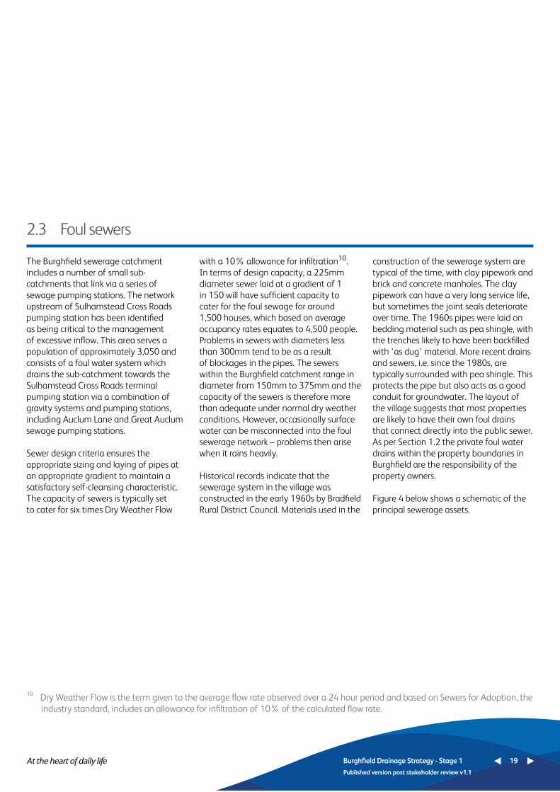
2.3 Foul sewers
The Burghfield sewerage catchment includes a number of small sub-catchments that link via a series of sewage pumping stations. The network upstream of Sulhamstead Cross Roads pumping station has been identified as being critical to the management of excessive inflow. This area serves a population of approximately 3,050 and consists of a foul water system which drains the sub-catchment towards the Sulhamstead Cross Roads terminal pumping station via a combination of gravity systems and pumping stations, including Auclum Lane and Great Auclum sewage pumping stations.
Sewer design criteria ensures the appropriate sizing and laying of pipes at an appropriate gradient to maintain a satisfactory self-cleansing characteristic. The capacity of sewers is typically set to cater for six times Dry Weather Flow
with a 10% allowance for infiltration10. In terms of design capacity, a 225mm diameter sewer laid at a gradient of 1 in 150 will have sufficient capacity to cater for the foul sewage for around 1,500 houses, which based on average occupancy rates equates to 4,500 people. Problems in sewers with diameters less than 300mm tend to be as a result of blockages in the pipes. The sewers within the Burghfield catchment range in diameter from 150mm to 375mm and the capacity of the sewers is therefore more than adequate under normal dry weather conditions. However, occasionally surface water can be misconnected into the foul sewerage network – problems then arise when it rains heavily.
Historical records indicate that the sewerage system in the village was constructed in the early 1960s by Bradfield Rural District Council. Materials used in the
construction of the sewerage system are typical of the time, with clay pipework and brick and concrete manholes. The clay pipework can have a very long service life, but sometimes the joint seals deteriorate over time. The 1960s pipes were laid on bedding material such as pea shingle, with the trenches likely to have been backfilled with ‘as dug’ material. More recent drains and sewers, i.e. since the 1980s, are typically surrounded with pea shingle. This protects the pipe but also acts as a good conduit for groundwater. The layout of the village suggests that most properties are likely to have their own foul drains that connect directly into the public sewer. As per Section 1.2 the private foul water drains within the property boundaries in Burghfield are the responsibility of the property owners.
Figure 4 below shows a schematic of the principal sewerage assets.
10 Dry Weather Flow is the term given to the average flow rate observed over a 24 hour period and based on Sewers for Adoption, the industry standard, includes an allowance for infiltration of 10% of the calculated flow rate.
Burghfield Drainage Strategy - Stage 1 19
Published version post stakeholder review v1.1

Figure 4 Burghfield sewerage catchment, showing principal assets
Burghfield Drainage Strategy - Stage 1 20
Published version post stakeholder review v1.1
Burghfield Drainage Strategy - Stage 1 19
Published version post stakeholder review v1.1
Gravity Sewer
Pumping Main
Watercourse
Catchment
Sewage pumping station
Sewage Treatment Works

The majority of Burghfield Common is served by a surface water system which drains to Burghfield Brook - a small unclassified watercourse that flows adjacent to the foul sewer though Pondhouse Copse between Burghfield Common and Burghfield. Pipe diameters range in size from between 150mm and 900mm towards the outfall.
The surface water from the remaining properties is likely to drain to nearby soakaways or to local watercourses. Soakaways can only function satisfactorily when ground conditions allow soakage and may be completely ineffective at
times of high groundwater levels. In some areas, we have seen examples of customers draining surface water through their foul drains when their soakaways do not work. This exacerbates capacity problems for other customers connected further downstream in the sewerage network.
The catchment is mostly rural and incorporates a network of roadside ditches and minor watercourses that are intended to take the surface water from roads and public spaces in the area. As per Section 1.2 the responsibility for the operation and maintenance of these ditches, local
watercourses and general land drainage is mostly with riparian owners. West Berkshire Council is responsible for the highway drainage and culverts crossing the highway, and as lead local flood authority has overall responsibility for managing groundwater.
The Environment Agency has the duty and the authority to ensure that the River Kennet and other main rivers in the area are maintained appropriately. The responsibility for maintenance lies with riparian owners.
2.4 Surface water sewers
Burghfield Drainage Strategy - Stage 1 21
Published version post stakeholder review v1.1

3 Long-term outcomes
We have listened very carefully to the views of customers before developing our plan for the Asset Management Period 6 (AMP6), regulatory period. Between 2009 and 2013 we carried out over 50 separate customer research and engagement activities.
Beyond being able to maintain the current service that we provide, customers have told us that they would like to see a reduction in instances of sewer flooding and odour nuisance and an improvement in river water quality. These are areas where some customers are prepared to pay for an improvement to the current level of service.
In response to this, we have developed 4 company outcomes and 11 service outcomes for our wastewater service that we are committed to working towards over the next 5 years and beyond, further details can be found in Table 1 below and on our website11.
Table 1 Wastewater outcomes
We will limit our impact on the environment and achieve a socially responsible, sustainable business for future generations, including reducing levels of leakage.
Asset health: maintaining our assets to ensure we can provide a safe and reliable service in the long-term.
Properties and public areas protected from flooding.
Resilient sewage treatment service that minimises the impact of extreme events on river water quality.
Do the basics excellently by getting things right first time.
Reduced dependence on energy from the grid.
Minimising our carbon footprint.
We must ensure an appropriate balance between reducing costs today and not compromising our future service.
Flooding is one of the worst service failures for customers.
We need to be able to provide service against a variety of pressures such as climate change and population growth.
This service outcome ensures our wholesale activity is completely aligned to our objective to improve our Service Incentive Mechanism (SIM) scoring.
Reducing dependence on energy from the grid is one of a range of measures across our entire plan to keep costs down to an affordable level for customers.
There is an expectation from society that we will play our part in reducing carbon emissions.
Company outcome
Wastewater service outcome
Why is this service outcome chosen
Our customers and stakeholders can trust us, we are easy to do business with and we care.
We will provide the level of customer service our customers require, in the most economic and efficient manner, to ensure that bills are no more than necessary.
We will provide a safe and reliable wastewater service that complies with all necessary standards and is available when our customers require it.
Burghfield Drainage Strategy - Stage 1 22
Published version post stakeholder review v1.1
11 See http://www.thameswater.co.uk/tw/common/downloads/about%20us%20-%20corporate%20responsibility/ AMP6_-_Outcomes_Reporting_Policy.pdf for more information.

River water quality meets customers’ expectations and regulatory requirements.
Satisfactory sludge disposal.
Corporate responsibility.
Reduced odour from wastewater operations.
Compliance with new environmental regulations.
We must meet environmental regulations, and river quality is a visible indicator to citizens of our environmental stewardship.Sludge is a resource that we should manage effectively to keep bills down.We will act as a responsible company, meeting expectations from wider society.Odour is a problem for some of our customers.We must meet environmental regulations, and river quality is a visible indicator to citizens of our environmental stewardship.
Company outcome
Wastewater service outcome
Why is this service outcome chosen
Below we provide more information about our asset health and properties and public areas protected from flooding service outcomes, as these are relevant to the Burghfield Drainage Strategy.
3.1 Asset health
Our Asset Health performance commitment encompasses a composite range of measures against which we will manage the health of our sewerage network. This commitment underpins our outcome of a safe and reliable wastewater
service. It includes sewer collapses, blockages, unconsented category 1 to 3 pollution incidents and properties internally flooded due to operational problems (such as blockages, collapses or equipment failures).
Burghfield Drainage Strategy - Stage 1 23
Published version post stakeholder review v1.1

There are two performance commitments that underpin the delivery of this service outcome:
1. We commit to protecting properties from flooding due to rainfall. We estimate that our plan for 2015-20 will result in over 2,100 properties being alleviated from internal flooding, external flooding and also from restricted toilet use (for example when
groundwater levels are high following prolonged periods of wet weather). Our customer research indicates that our sewer flooding programme will deliver £20m of benefit to customers every year by 2020.
2. We commit to reducing the risk of sewer flooding and pollution from combined sewers (i.e. those that convey both foul and surface water), by slowing down surface water run-off and re-
routing the flow through sustainable drainage measures such as water butts, permeable paving, rain gardens and green roofs. We aim to retrofit over 20 hectares of sustainable drainage measures by 2020. We may also apply this commitment to areas where the network was designed to take foul flow only, but investigation shows that a substantial amount of surface water is in the foul sewer.
We have a performance commitment to reduce the number of pollution incidents as a result of discharges from our sewerage network and treatment works. Pollution can occur as a result of blockages, collapses or failure of our
equipment and also following heavy rainfall when our sewers have insufficient capacity to cope with the flow. All pollution incidents are reported to the Environment Agency’s National Incident Recording System (NIRS).
3.2 Properties and public areas protected from flooding
3.3 River water quality meets customers’ expectations and regulatory requirements
Burghfield Drainage Strategy - Stage 1 24
Published version post stakeholder review v1.1

4 Current issues
4.1 Recent wet weather events
The foul sewerage system in Burghfield has become overwhelmed in recent years, following prolonged heavy rainfall. This has been associated with sewer flooding. Based on earlier investigations and site reconnaissance that we have carried in the winter of 2013/2014 we believe that the system has surcharged due to a combination of localised groundwater infiltration, surface water run-off from saturated fields, surface water inundation
from highways, public spaces and properties, overflowing watercourses and surface water misconnections.
We are confident that this is a comprehensive list of factors that have caused flooding.
The following incidents have been observed with respect to the sewerage network:
• Surcharging sewers have caused 3 ‘category 3’ pollution incidents as sewage has overflowed onto allotments upstream of the pumping station.
During these events, other sources of flooding have also been observed: • highway drainage overwhelmed
causing highway flooding.• Surface water run-off from fields
Burghfield Drainage Strategy - Stage 1 25
Published version post stakeholder review v1.1

Burghfield Drainage Strategy - Stage 1 25
Published version post stakeholder review v1.1
Burghfield Drainage Strategy - Stage 1 26
Published version post stakeholder review v1.1
4.2 Our operational response
During extended wet periods, treated flows at the sewage treatment works can be in excess of 5,000 m3/day, which is over two times greater than the consented dry weather daily flow of 2,200 m3/day. Figure 5 compares the treated flows at Burghfield sewage treatment works with groundwater levels recorded at an Environment Agency borehole. The ground water remained at levels of 1m to 6m below surface for much of the time between 2007 and 2014 and the sewers, which are typically 0.8m to 5.1m deep,
will have been within the ground water table for most of this period. However, there is no clear correlation between groundwater levels and flow at the sewage treatment works. It is therefore likely that the high inflow in the catchment is not predominantly due to infiltration, but a result of surface water directly connected to the foul sewer and inundation of the foul sewer from fluvial flooding.
Due to the significant impacts of fluvial and groundwater flooding across our
region during the winter event of 2013/14, we decided to mobilise our tanker fleet of nearly 100 vehicles to protect customers at greatest risk of flooding inside their homes. For this reason, and recognising the limited effectiveness of tankering following more extreme weather conditions, tankering was not generally utilised in the Burghfield catchment in 2013/14. However, a tanker was required to maintain service at Sulhamstead sewage pumping station due to a power failure in May 2014.

Burghfield Drainage Strategy - Stage 1 27
Published version post stakeholder review v1.1
Figure 5 Burghfield Sewage treatment works treated flows and groundwater levels

Burghfield Drainage Strategy - Stage 1 27
Published version post stakeholder review v1.1
4.3 Investigations and activities completed to date
Table 2 below, details the investigations and actions that we have completed in recent years within the Burghfield catchment. These form the extent of our current understanding of issues within the catchment.
Permanent depth monitorsInflow and infiltration study
‘Lift and Look’ manhole survey as part of study
Network Ops. CCTV survey as part of study
Manhole Cover Replacement
Sewer Flooding Clean-up
To gain an understanding of catchment response to prolonged.Study to investigate the source of inflow into the foul water sewer networks.
Ascertain the sources of surface water inflow and infiltration into the foul water network.
Ascertain the sources of Surface Water inflow and infiltration into the Foul Water Network.
Flood seals installed on flooding manholes within the allotments to reduce likelihood of pollution incidents.
Thames Water schedule clean-ups after sewer flooding events to ensure public health and safety.
Prior to 2012
August 2013
2013
2013
08/11/13
11/02/14
Permanent depth monitor installed at Sulhamstead Cross Road.Identified evidence of previous infiltration and inflow from staining, encrustation and high level water marks in chambers. Minor increases in clear flow were observed along certain sewers from surface water and cellar connections as well as infiltration from broken lateral connections. Some evidence of previous inflow and infiltration within the network. Section of pipe along Pondhouse Copse appears to be a hot spot of inflow into the network.Some evidence of previous inflow and infiltration within the network. Not possible to camera survey the Pondhouse Copse section.5 Low Leak and Flood seal covers installed between 15/06/2012 and 08/11/2013.
2 clean-up activities recorded between 15/06/2012 and 11/02/2014.
Activity Purpose Date complete Outcome
Burghfield Drainage Strategy - Stage 1 28
Published version post stakeholder review v1.1
Table 2 Investigations and activities completed

Burghfield Drainage Strategy - Stage 1 29
Published version post stakeholder review v1.1
In summary, following previous concerns that the sewerage network upstream of Sulhamstead Cross Roads sewage pumping stations experienced very high flows following heavy rainfall and excessive infiltration, an investigation was undertaken in 2013 to identify sources of groundwater or surface water ingress
in this area. Sewers were surveyed and manholes were inspected and some minor flows were found. Other maintenance activities have been completed to address sewer misuse and fats, oils and grease. Further work is required to better understand flow in the sections of sewer that pass through Pondhouse
Copse between Burghfield Common and Burghfield. Permanent depth monitors were installed into the sewer network in Winter 2014 which we will continue to monitor as our strategy develops through this 4-stage framework process.
Activity Purpose Date complete Outcome
Permanent monitoring of sewer levels
Root Cutting
Sewer Cleaning
Installation of permanent depth monitors into the foul sewers at five locations in the Burghfield catchment. Plan is for monitors to remain in situ for at least 5 years and to capture the next wet weather event as a minimum. Analyse the recorded depths and compare with other catchment variables, such as rainfall events and changes in groundwater levels. Planned and reactive root cutting to prevent flooding from blockagesPlanned and reactive sewer cleaning (removal of grit and debris)
December 2014
Ongoing
Ongoing
Permanent monitoring of sewer levels
Regular root cutting takes place along Anstey Place and Valley RoadMaintain ‘asset health’
Burghfield Drainage Strategy - Stage 1 30
Published version post stakeholder review v1.1
Table 3 Actions by other stakeholders to prevent flooding
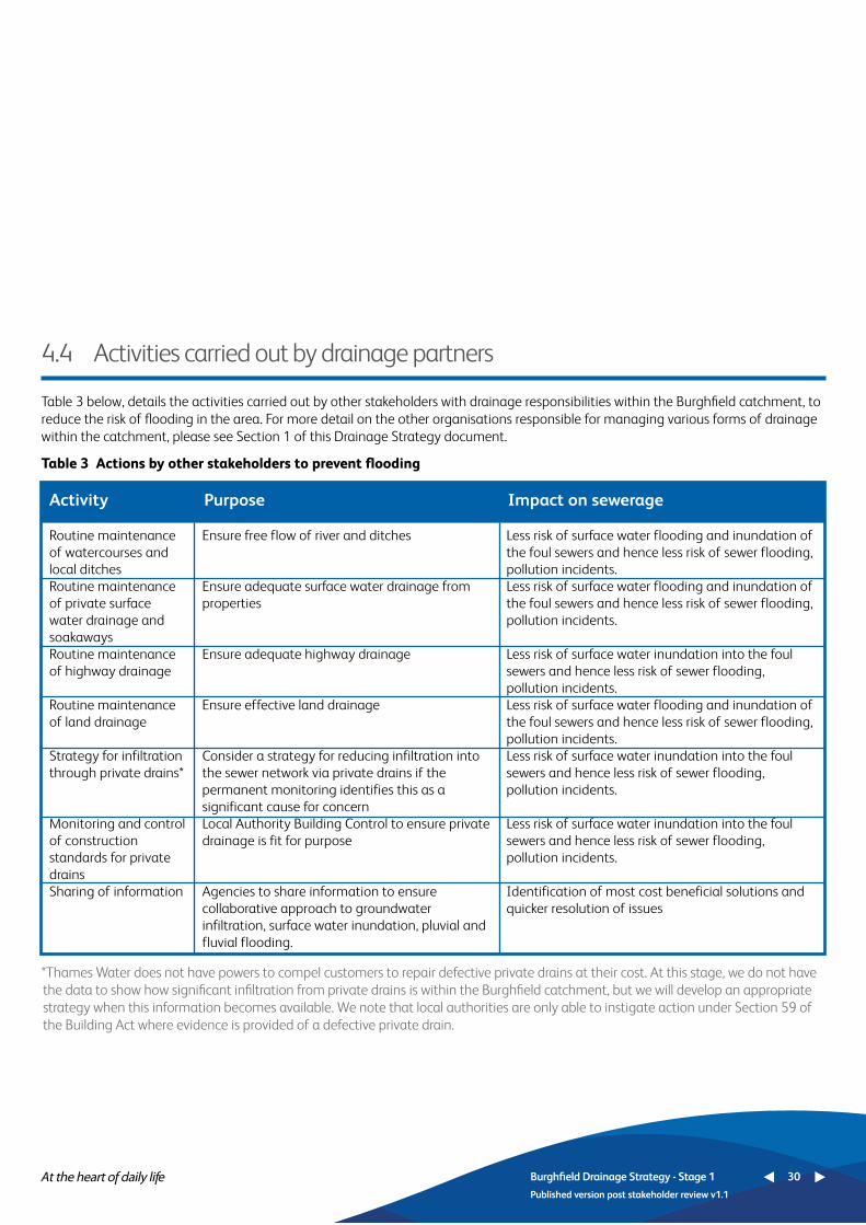
4.4 Activities carried out by drainage partners
Table 3 below, details the activities carried out by other stakeholders with drainage responsibilities within the Burghfield catchment, to reduce the risk of flooding in the area. For more detail on the other organisations responsible for managing various forms of drainage within the catchment, please see Section 1 of this Drainage Strategy document.
*Thames Water does not have powers to compel customers to repair defective private drains at their cost. At this stage, we do not have the data to show how significant infiltration from private drains is within the Burghfield catchment, but we will develop an appropriate strategy when this information becomes available. We note that local authorities are only able to instigate action under Section 59 of the Building Act where evidence is provided of a defective private drain.
Routine maintenance of watercourses and local ditchesRoutine maintenance of private surface water drainage and soakawaysRoutine maintenance of highway drainage
Routine maintenance of land drainage
Strategy for infiltration through private drains*
Monitoring and control of construction standards for private drainsSharing of information
Ensure free flow of river and ditches
Ensure adequate surface water drainage from properties
Ensure adequate highway drainage
Ensure effective land drainage
Consider a strategy for reducing infiltration into the sewer network via private drains if the permanent monitoring identifies this as a significant cause for concernLocal Authority Building Control to ensure private drainage is fit for purpose
Agencies to share information to ensure collaborative approach to groundwater infiltration, surface water inundation, pluvial and fluvial flooding.
Less risk of surface water flooding and inundation of the foul sewers and hence less risk of sewer flooding, pollution incidents.Less risk of surface water flooding and inundation of the foul sewers and hence less risk of sewer flooding, pollution incidents.
Less risk of surface water inundation into the foul sewers and hence less risk of sewer flooding, pollution incidents.Less risk of surface water flooding and inundation of the foul sewers and hence less risk of sewer flooding, pollution incidents.Less risk of surface water inundation into the foul sewers and hence less risk of sewer flooding, pollution incidents.
Less risk of surface water inundation into the foul sewers and hence less risk of sewer flooding, pollution incidents.
Identification of most cost beneficial solutions and quicker resolution of issues
Activity Purpose Impact on sewerage

In 2011, Ofwat commissioned Mott MacDonald to look at factors likely to affect sewerage networks in the future. The report ‘Future impacts on sewer systems in England and Wales’ (June 2011)12 looked at the likely relative impact of climate change, population growth and impermeable areas up to around 2040. In preparing our plan for 2015-2020, we have also carried out research into these factors across the Thames Water region. We summarise our findings for the Burghfield catchment in this section.
Burghfield Drainage Strategy - Stage 1 31
Published version post stakeholder review v1.1
5 Future challenges
5.1 Urban creep
Urban creep is defined as the transformation of a catchment by the paving over of previously permeable areas. Rather than surface water soaking into the ground when it rains heavily, more water runs off into the sewerage network and can cause the sewers to surcharge and flood. It is therefore important to understand the rate at which urban creep is occurring.
We have studied aerial photography and satellite imagery across 11 catchments across the Thames Water region using data from two periods in the late 1990s and mid-2000s to determine the rate at which urban creep is occurring. We then carried out a statistical analysis and built
a model to predict the rate of urban creep for the entire Thames Water region, taking account of factors such as property age, land use, demographics such as family sizes and financial income, need and available space. We found that affluent suburban areas with detached and semi-detached properties, where families have young children, are most likely to have high urban creep rates.
The results for the Thames Region are presented in Figure 6 below. The urban creep rate for Burghfield is 0.1026%. In other words, this is the increase in impermeable area per year as a percentage of the total area connected to the sewerage network. When compared
against the rest of the Thames Water region, Burghfield is above average, but not as high as suburban areas around central London and major towns. We will continue to monitor change in impermeable area as the strategy continues to develop. If we observe an increase in urban creep, we will raise the issue with West Berkshire District Council who is responsible for managing surface water. We may then also look to retrofit sustainable drainage measures (such as permeable paving and water butts) in the area to counter the increased run-off following rainfall, to reduce the risk of flooding.
Figure 6 Urban creep rates in the Thames Water region
12 Mott MacDonald, Future impacts on sewer systems in England and Wales, June 2011.
Burghfield

Figure 7 Locations assessed for increased rainfall intensity by 2080
5.2 Climate change
We have analysed the 2009 UK Climate Projections (UKCP09) to determine the likely increase in rainfall intensity due to climate change in 15 catchments across our region13. More intensive rainfall in the future will increase the peak flow in sewerage networks and with it the likelihood of sewer flooding.
15 catchments across our region were
selected to give a representative sample of inner London, outer London and more rural areas in the Thames Valley. A number of these catchments are also areas which experience sewerage related issues like pollution, flooding and urban creep.
We assessed different combinations of emission scenarios and climate change percentiles for each of the 15 catchments.
The nearest catchment to Burghfield that was analysed for climate change was Wokingham. The results show a central estimate of an increase of 15% in rainfall by 2080, but in some scenarios this could be as high as 25% or as low as 5%. We will ensure that our strategy takes account of these potential increased peak flows as it develops.
Increased rainfall intensity may not be the only consequence of climate change. UKCP09 data also suggests that the UK is likely experience longer wetter winters in future. Further research is needed to understand whether high groundwater levels, such as those observed in the winters of 2012/13 and 2013/14 are
likely to become more frequent in future. As the recent experience of prolonged rainfall and high groundwater levels have been shown to be the principal factors, this research will be very significant in informing any risk assessment and appraisal of costs and benefits of solutions.
Burghfield Drainage Strategy - Stage 1 32
Published version post stakeholder review v1.1
13 Atkins, Thames UKCP09 Rainfall Intensity Assessment Revised Report, October 2012.
Burghfield
Thames Locations
High (90th)Medium (50th)Low (10th)County boundaryMotorwayUrban areas
Key
Percentiles

5.3 Population growth and new development
We use a combination of top-down and bottom-up information to ensure that our forecast of population and new development is as robust as possible to keep costs down, in order to minimise the bill impact of any investment that may be necessary.
Our forecast of the number of new households is taken directly from Experian data. We have used the ‘Plan-Based’ projection which uses information provided by local authorities about planned numbers of new dwellings in their respective areas. During the period 2015 to 2020 we expect to see an increase in new development across that Thames Water region and are forecasting a total of 263,000 new connections to the sewerage network during this time.
Our Development Tracker System (DTS), is used to track developer enquiries through the planning process to construction. When we are contacted by a developer, we typically carry out preliminary modelling to determine whether our network or treatment works has the capacity to accommodate the increase
in flow. Where it does not, we propose planning conditions for consideration by the Planning Authority, although we encourage developers to contact us as early as possible in the planning process to avoid this.
The independent review into the causes of the 2007 floods (The Pitt Review), concluded Sustainable Drainage Systems (commonly known as SuDS), are an effective way to reduce the risk of ‘flash-flooding’ which occurs when rainwater rapidly flows into the public sewerage and drainage systems, causing overloading and back-up of water. Typically, SuDS slow the rate of surface water run-off entry into the drainage system and improve the percolating feature, ie rainfall recharging the groundwater system, thus mimicking natural drainage processes. In April 2015, the Government made changes to the planning process effecting planning policies and decisions on planning applications of 10 dwellings or more (or equivalent non-residential or mixed development), to ensure that sustainable drainage systems are put in place, unless demonstrated to be
inappropriate. This requires that when considering planning applications, local planning authorities should consult the relevant Lead Local Flood Authority (County Council or Unitary Authority) on the management of surface water, to satisfy themselves that the proposed standards of operation are appropriate and ensure, through the use of planning conditions or planning obligations, that there are clear arrangements in place for ongoing maintenance over the lifetime of the development.
In the case of Burghfield, whilst SuDS might help to reduce the risk of flooding following rainfall when groundwater levels are low (i.e. typically during summer months), they may not be as effective in reducing the flood risk when groundwater levels are high (typically during the winter months). We will therefore take account of the potential influence of groundwater when we come to assess any options as part of this drainage strategy framework process.
The West Berkshire Core Strategy published in 2012 identifies growth of
Burghfield Drainage Strategy - Stage 1 33
Published version post stakeholder review v1.1

approximately 800 dwellings between 2006 and 2026 in the East Kennet Valley area. It identifies that at March 2011 there had already been considerable housing commitments leaving only approximately 320 dwellings to be allocated. Burghfield Common is one of two areas identified as the focus for development in this area, with development taking the form of small extensions to the village. The Strategic Housing Site Allocation Plan identifies a ‘basket’ of potentially developable sites from which to select.
Using sources that include the West Berkshire Council Development Plan, Core Strategy, and Strategic Housing Site Allocations Plan, along with third party planning enquiries, the key development sites that we are currently tracking in Burghfield include:
• 105 dwellings to be built on land adjoining Pondhouse Farm, Clayhill Road
• 85 dwellings to be built on land to the rear of The Hollies Nursing Home, Reading Road,
• 28 dwellings land adjacent to Primrose Croft, Reading Road.
• 125 dwellings - Western part of the site adjoining Holly Bush Lane to be considered.
• 124 dwellings - land at Gully Copse, Burghfield Common Reading
• 70 dwellings - North Of Grove Copse South Of Mans Hill Burghfield Common Reading.
Other applications exist but relate to developments where detailed numbers have not been confirmed or single properties. We will continue to monitor future plans for the catchment through our stakeholder engagement work.
Concerns have been raised with West Berkshire Council regarding further development in the Sulhamstead Cross Roads sewage pumping station sub-catchment and we have requested that drainage conditions should be imposed on any planning applications. A key element of our assessments will be to establish the extent to which these developments may be significant in the context of the sewer flooding challenges currently experienced in the catchment. This assessment work will be undertaken and findings shared in an update to this Strategy document.
Burghfield Drainage Strategy - Stage 1 34
Published version post stakeholder review v1.1

6 Strategy development
The Drainage Strategy for the Burghfield catchment is currently at Stage 1 (Initialise/prepare), of the 4-stage framework process. The following activities in Table 4, are planned and ongoing, in order to carry out the risk assessment and development of our strategy options.
Activity Purpose Date planned Outcome
Stakeholder engagement
Permanent monitoring of sewer levels
Permanent monitoring of pumping station
Customer surveys
Sewer and manhole surveys
Connectivity surveys
This document will be circulated to the Environment Agency, Lead Local Flood Authority and West Berkshire District Council before being published on our website. The Local Flood Forum will continue to be used as the primary route for stakeholder engage-ment. All third party data will contribute to drainage strategy development.Continue monitoring sewer depth monitors installed last year. Plan is for monitors to remain in situ for at least 5 years and to capture the next wet weather event as a minimum. Analyse the recorded depths and compare with other catchment variables, such as rainfall events and changes in groundwater levels. Install permanent monitor on rising main to establish pumped flows from Sulhampstead Cross Roads sewage pumping station.
Validate the historical records of flooding and restricted toilet use in the catchment to enable a detailed benefits assessment of potential further intervention options that could be implemented by Thames Water.Ascertain sewer and manhole condition and evidence of infiltration via CCTV survey and manhole “lift and look” surveys when appro-priate.Carry out visual inspection of properties to determine the extent of roof drainage and other surface water drainage that discharges into the foul sewer network when appropriate.
Stakeholders informed about progress and timing of works to reduce the risk of flooding. Work carried out by Thames Water is coordinated with activities of other partners involved with drainage.
Use information to identify additional actions for inclusion in the drainage strategy for Burghfield. Share information with other agencies.
Use information to identify additional actions for inclusion in the drainage strategy for Burghfield. Share information with other agencies. Use information to help test the cost benefit of options to improve drainage and reduce the risk of sewer flooding in the Burghfield catchment.
Use information to identify additional actions for inclusion in the drainage strategy for Burghfield. Share information with other agencies.A better understanding of the contribution that misconnections make to sewer flooding in the area.
Ongoing
Ongoing
From winter 2015
From winter 2015
From winter 2015
From winter 2015
Burghfield Drainage Strategy - Stage 1 35
Published version post stakeholder review v1.1
Table 4 Activities planned and ongoing to enable strategy development

Activity Purpose Date planned Outcome
Pilot trials of mobile treatment plant
Consider innovative solutions
Update drainage strategy
As part of our wider approach to managing high groundwater levels, we are trialling the use of biological filters elsewhere. Our findings will inform and may influence our strategy plans for the Burghfield catchment. If successful, these could be used to abstract dilute sewage from surcharged sewers and discharge it safely to a watercourse.To identify quicker / cheaper / collaborative options that improve the benefit to cost ratio in order to keep customers’ bills down, to prioritise investment and to ensure greatest benefit to customers.Improve the drainage strategy based on the initial results from the permanent monitoring, customer surveys, misconnection surveys and feedback from stakeholders.
Service may be restored for customers without the need for tankering.
Enhanced toolkit available to reduce the risk of sewer flooding and then apply this once data becomes available.
Risk assessment, options appraisal and preferred strategy to be completed, subject to capturing weather events through monitoring and surveys.
Ongoing
Ongoing
2017
Burghfield Drainage Strategy - Stage 1 36
Published version post stakeholder review v1.1

Localised sewer rehabilitation
Manhole cover replacementConnectivity surveys
Sewer and manhole surveys
Undertake localised sewer rehabilitation to include lining, patch repairs, localised pipe replacement and manhole repairs identified through survey work and where considered cost effective in reducing ingress of ground water. Replace manhole covers with leak tight covers where identified through survey work.Carry out visual inspection of properties to determine the extent of roof drainage and other surface water drainage that discharges into the foul sewer network when appropriate.Ascertain pipe condition via CCTV survey and identify possible sources of inflows including unrecorded pump discharge.
When identified
When identifiedWhen identified
When identified
Reduce infiltration into the public sewers.
Stop ingress of surface water through manholes located in flood plain.A better understanding of the contribution that misconnections make to sewer flooding in the area.
Identify type and source of inflow.
Activity Purpose Date planned Outcome
7 Preferred strategy and plan
We believe that the foul sewerage system in Burghfield has surcharged and flooded predominantly due to a combination of localised groundwater infiltration to public sewers and private drainage, surface water run-off from saturated fields, surface water inundation from highways, public spaces and properties, surface water misconnections and river water overflowing from watercourses.
Our network strategy is to understand the relative impact that each of these factors has on the risk of sewer flooding, and then to develop a plan comprising cost beneficial solutions using customer willingness to pay research. In parallel, we will assess the extent to which new developments may be significant in the context of challenges currently experienced and where necessary we will
develop solutions to accommodate the proposed development in the catchment.
We may carry out some repair works as this strategy develops, in the event that our investigations identify faults or problems with the sewerage network that are highly likely to have caused flooding. Table 5 below lists the activities that we have identified to date.
Our plan will be updated and shared once the Risk Assessment and Options Appraisal sections have been completed in accordance with the Drainage Strategy framework.
Table 5 Activities identified in preferred plan to date
Burghfield Drainage Strategy - Stage 1 37
Published version post stakeholder review v1.1

8 Temporary overflows
We have not installed temporary pipework and pumps in the sewerage network during wet weather events in the Burghfield catchment to maintain service, but we would consider doing so to prevent the backup of sewerage into customers’ properties and uncontrolled spilling from the sewer system into the environment.
As part of the stage 2 risk assessment and stage 3 options appraisal, we will be
investigating the circumstances under which emergency discharges would be required in future, such as the use of temporary overflows, to pump out from the sewerage network through biological filters to maintain service to customers and prevent homes from flooding. As this Drainage Strategy develops, in this section we will describe the location of any proposed temporary overflows and the circumstances under which we would use
them, in order that this Drainage Strategy, together with our plans to reduce infiltration, fully meets the requirements of an Infiltration Reduction Plan as set out in the Environment Agency’s Regulatory Position Statement. We will continue to identify sewer rehabilitation and other permanent works to reduce groundwater infiltration alongside refining the use of temporary overflows.
Burghfield Drainage Strategy - Stage 1 38
Published version post stakeholder review v1.1

Burghfield Drainage Strategy - Stage 1 39
Published version post stakeholder review v1.1
Appendix A Glossary of terms
Blockages Obstacles or the build-up of fat and grease, block or obstruct our sewerage pipes. This is normally caused by things which should not be flushed, or poured, into drains and sewers.
Combined sewer A pipe conveying the combined rainwater and contaminated wastewater from two or more properties. A combined sewer is designed to carry wastewater to a sewage works for treatment but during periods of heavy rainfall or snowmelt, the volume in a combined sewer system can exceed the capacity of the sewer system or treatment plant. For this reason, combined sewer systems are designed to overflow occasionally and discharge excess wastewater directly to nearby streams, rivers, or other water courses.
Dry weather The average flow rate observed over a 24 flow hour period in dry weather and based on
Sewers for Adoption, the industry standard, includes an allowance for infiltration of 10% of the calculated flow rate.
Foul drain A pipe conveying the contaminated wastewater from a single property. If the pipe extends beyond the property boundary, the portion of the pipe outside of the boundary is termed a lateral drain. The portion of the pipe inside the boundary is a private drain. On 1 October 2011 water and sewerage companies in England and Wales became responsible for lateral drains, which were previously the responsibility of property owners. Private drains remain the responsibility of property owners.
Foul sewer A pipe conveying the sewage from two or more properties. On 1 October 2011, water and sewerage companies in England and Wales also became responsible for private sewers, which were previously the responsibility of property owners. A foul sewer is designed to carry contaminated wastewater to a sewage works for treatment. It disposes of wastewater from sources including toilets, baths, showers, kitchen sinks, washing machines and dishwashers.
Infiltration Groundwater finds its way into the sewerage system (including private drains), via defective pipes or pipe joints and through
the brickwork or defects in manhole structures.
Inundation Accumulated surface water from rain and/or river floodwater that has resulted in localised flooding, finds its way into the sewerage system through manhole covers and drains. These may be public or private.
Lateral drain See definition for Foul drain.Misconnections Property owners have connected rainwater(surface water to and/or land drainage to our sewers (e.g. roof foul water) drainage, paved driveways drains, soakaway
overflows), and can cause major issues for the performance of the sewerage system.
Misconnections A plumbing mistake resulting in wastewater (foul water to appliances being misconnected to the surface water) surface water system. Private sewers See definition for Foul sewer.Rainfall induced Sewer infiltration that occurs as a result infiltration of rainfall percolating into the ground
impacting the sewer on route to recharging the groundwater table.
Riparian owner If you own land adjoining, above or with a watercourse running through it, you have certain rights and responsibilities. In legal terms you are a ‘riparian owner’. If you rent the land, you should agree with the owner who will manage these rights and responsibilities.
Soakaway Surface water from a roof and driveway of a property is piped to an underground pit, usually filled with gravel or similar material. Some soakaways are situated within the boundary of the property.
Surface water A pipe conveying uncontaminated rainwaterdrain from a single property.Surface water A pipe containing uncontaminated sewer rainwater from two or more properties. A
surface water sewer is designed to dispose of rainwater from roofs, driveways, patios, roads, etc to a local watercourse.
Sustainable Measures designed to attenuate and slow Drainage down surface water before it enters sewersSystems (SuDS) to reduce the risk of flooding following
heavy rainfall. Includes green infrastructure such as raingardens, green roofs as well as other measures, such as permeable paving and water butts.
Term Definition Term Definition

Appendix B Supporting figures and photographs
Figure B1 Fluvial flood risk for Burghfield based on Environment Agency plans
Burghfield Drainage Strategy - Stage 1 40
Published version post stakeholder review v1.1
This flood risk map information has been sourced from the Environment Agency website. For more detailed flood map information for this catchment, please access the Environment Agency website.
Flood Zone 3
Flood Storage Area
Nat Defences
Flood Zone 2

Figure B2 Surface water flood risk for Burghfield based on Environment Agency plans
Burghfield Drainage Strategy - Stage 1 41
Published version post stakeholder review v1.1
This flood risk map information has been sourced from the Environment Agency website. For more detailed flood map information for this catchment, please access the Environment Agency website.
100 Yr SW Risk
30 Yr SW Risk

Burghfield Drainage Strategy - Stage 1 41
Published version post stakeholder review v1.1
Figure B3 Groundwater flood risk for Burghfield
Burghfield Drainage Strategy - Stage 1 42
Published version post stakeholder review v1.1
ESI Groundwater Flood Risk Map of England and Wales © www.esinternational.com
Low Risk
Moderate Risk
High Risk
This groundwater flood risk map information has been sourced from ESI Ltd.

Figure B4 Burghfield watercourses
Burghfield Drainage Strategy - Stage 1 43
Published version post stakeholder review v1.1
This watercourse map information has been sourced from the Environment Agency website. For more detailed flood map information for this catchment, please access the Environment Agency website.

Burghfield Drainage Strategy - Stage 1 43
Published version post stakeholder review v1.1
Figure B5 Burghfield bedrock and drift geology
Burghfield Drainage Strategy - Stage 1 44
Published version post stakeholder review v1.1
This geological map information has been sourced from the British Geological Survey website. For more detailed geological information for this catchment, please access the British Geological Survey website.

Photographs taken during wet weather of 2013/14
Burghfield Drainage Strategy - Stage 1 45
Published version post stakeholder review v1.1
Photo 1 – Sulhampstead Road pumping station
Photo 3 – Ground water ponding adjacent to Reading Road
Photo 2 – Ground water ponding adjacent to Reading Road

Burghfield Drainage Strategy - Stage 1 45
Published version post stakeholder review v1.1
![Thames Region Land Drainage - gov.uk · Thames Water Authority LAND DRAINAGE BYELAWS 1981 [as amended by the Thames Region FLOOD DEFENCE BYELAWS 1991] The Thames Water Authority,](https://img.dokumen.tips/doc/110x75/5ead899913c7690cc165ecc9/thames-region-land-drainage-govuk-thames-water-authority-land-drainage-byelaws.jpg)