Embed Size (px)
Citation preview

BUILDING STRONG®
South Platte CWMS ModelMissouri Basin Forecasters Meeting
January 29, 2014
South Platte CWMS ModelMissouri Basin Forecasters Meeting
January 29, 2014
Brian Twombly, Omaha District, Corps of Engineers

BUILDING STRONG®
Corps Water Management System (CWMS)
Developed by the Hydrologic Engineering Center (HEC). Software that Interfaces:
• Data Acquisition• Data Storage• HEC-HMS (rainfall/runoff)• HEC-ResSim (reservoir routing)• RiverWare (river system)• HEC-RAS (hydraulics)• HEC-FIA (economic consequences)
HEC-RTS is the personal computer version of CWMS that interfaces all the models without the database connections.

BUILDING STRONG®

BUILDING STRONG®
HEC-HMS
Three models were developed:• Upper Basin Snow• Upper Basin Rain• Middle Basin Rain

BUILDING STRONG®
Upper South Platte- Two different basins: Rain and Snow- Gridded snow and air temp from CRREL and NOHRSC
BUILDING STRONG®
Mid South Platte- Requires an input at the Waterton gage either from the upper HMS or NWS forecast.

BUILDING STRONG®
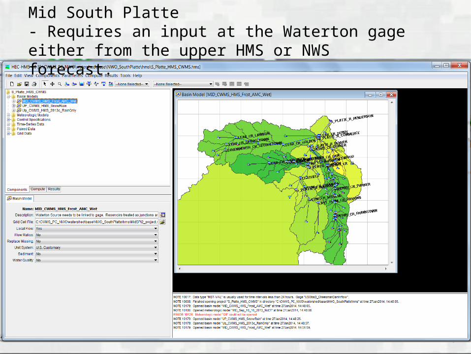
HEC-ResSim
HMS inflows fed into ResSim ResSim computes reservoir releases for:
►Chatfield►Cherry Creek►Bear Creek
BUILDING STRONG®

BUILDING STRONG®
HEC-RAS
Uses outflow from ResSim in reaches downstream of the reservoirs.
HMS provides flows to other reaches.
BUILDING STRONG®
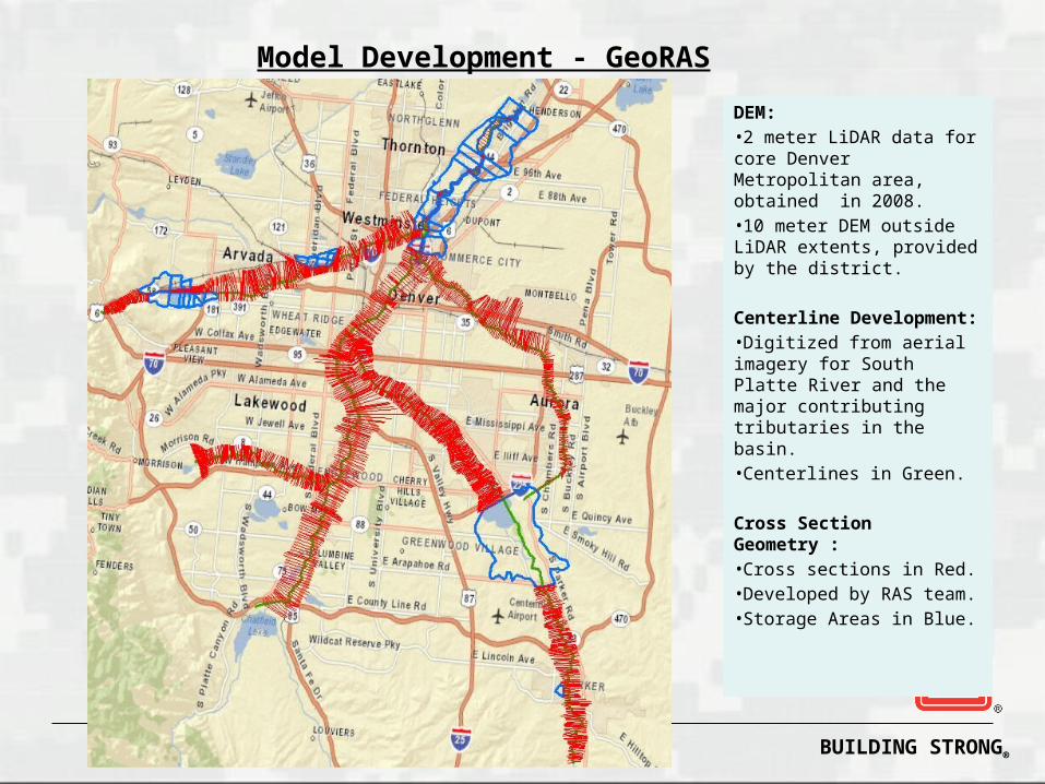
Model Development - GeoRAS
DEM:•2 meter LiDAR data for core Denver Metropolitan area, obtained in 2008. •10 meter DEM outside LiDAR extents, provided by the district.
Centerline Development:•Digitized from aerial imagery for South Platte River and the major contributing tributaries in the basin.•Centerlines in Green.
Cross Section Geometry :•Cross sections in Red.•Developed by RAS team.•Storage Areas in Blue.

BUILDING STRONG®
HEC-FIA
Calculates flood damages and loss of life Uses inundations calculated in HEC-RAS

BUILDING STRONG®
Data Needs
Forecasted Temperature Grids►CRREL to provide grids from NOHRSC►3 days forecasted temperature►Any other sources of grids?
Historical gridded temperature and precipitation►Could be used to develop spaghetti plots and
probabilistic forecasts.

BUILDING STRONG®
Data Needs
NWS Waterton Forecast►6 hour time step►Could be used instead of running the upper
HMS model. How are the radar precipitation grids
ground truthed?

BUILDING STRONG®
Questions
Brian Twombly, P.E.
(402)995-2316

BUILDING STRONG®
South Platte ResSimSimulations
Sept 2013 Flood Simulation
Transposed rainfall grid for 10-16 Sept 2013
Created new rainfall grid over reservoir watersheds
Developed hydrographs using 75% HMS models
Create a Sept 2013 ResSim simulation using HMS results

BUILDING STRONG®
South Platte ResSimSept 2013 Simulation
Transposed Rainfall Grid
HEC-MetVue, Gage Interp, ArcGis
Created a grid of circles with Excel and ArcGis
Transposed gridded rainfall with MetVue
Re-sampled gridded rainfall by average rainfall for each circle over the time period of the gridded rainfall dss file
Created a new gridded rainfall file with Gage Interp

BUILDING STRONG®
South Platte ResSimSept 2013 Simulation

BUILDING STRONG®
Sept 2013 SimulationCherry Creek Basin Storm Centering

BUILDING STRONG®
Sept 2013 SimulationDownstream Storm Centering


![North Platte Tribune. (North Platte, NE) 1894-11-07 [p ]](https://img.dokumen.tips/doc/110x75/6194f7b6b7b4a03a236f33dd/north-platte-tribune-north-platte-ne-1894-11-07-p-.jpg)