Embed Size (px)
Citation preview

CYNGOR CEFN GWLAD CYMRU COUNTRYSIDE COUNCIL FOR WALES
CORE MANAGEMENT PLAN INCLUDING CONSERVATION OBJECTIVES
FOR
Blaen Cynon Special Area of Conservation (SAC). Version: 1 Date: 28th February 2008 Approved by: David Mitchell A Welsh version of all or part of this document can be made available on request.

2
CONTENTS Preface: Purpose of this document 1. Vision for the Site 2. Site Description
2.1 Area and Designations Covered by this Plan 2.2 Outline Description 2.3 Outline of Past and Current Management 2.4 Management Units
3. The Special Features
3.1 Confirmation of Special Features 3.2 Special Features and Management Units
4. Conservation Objectives Background to Conservation Objectives Conservation Objective for 4.1 Feature 1: Marsh fritillary butterfly Euphydryas (Eurodryas, Hypodryas) aurinia 4.2 Feature 2: Marshy Grassland 4.3 Feature 3: Flush and Spring 4.4 Feature 4: Raised Bog 4.5 Feature 5: Species-rich Neutral Grassland 4.6 Feature 6: Acid Grassland 4.7 Feature 7: Semi-natural Broadleaved Woodland
5. Assessment of Conservation Status and Management Requirements: for
5.1 Feature 1: Marsh fritillary butterfly Euphydryas (Eurodryas, Hypodryas) aurinia 5.2 Feature 2: Marshy Grassland 5.3 Feature 3: Flush and Spring 5.4 Feature 4: Raised Bog 5.5 Feature 5: Species-rich Neutral Grassland 5.6 Feature 6: Acid Grassland 5.7 Feature 7: Semi-natural Broadleaved Woodland
6. Action Plan: Summary 7. Glossary

3
PREFACE This document provides the main elements of CCW’s management plan for the site named. It sets out what needs to be achieved on the site, the results of monitoring and advice on the action required. This document is made available through CCW’s web site and may be revised in response to changing circumstances or new information. This is a technical document that supplements summary information on the web site. One of the key functions of this document is to provide CCW’s statement of the Conservation Objectives for the relevant Natura 2000 site. This is required to implement the Conservation (Natural Habitats, &c.) Regulations 1994, as amended (Section 4). As a matter of Welsh Assembly Government Policy, the provisions of those regulations are also to be applied to Ramsar sites in Wales.

4
1. VISION FOR THE SITE This is a descriptive overview of what needs to be achieved for conservation on the site. It brings together and summarises the Conservation Objectives (part 4) into a single, integrated statement about the site. This statement also reflects the Site Management Statements for the two SSSIs concerned: The site is part of a wider area used by a metapopulation of marsh fritillary butterfly. Cors Bryn-y-Gaer SSSI and the nearby Woodland Park and Pontpren SSSI will contribute towards supporting the metapopulation of marsh fritillary in the Penderyn/Hirwaun area. These two sites comprise the Blaen Cynon Special Area of Conservation (SAC). The various habitats within the SAC will be managed for the benefit of this butterfly. Wet grassland covers at least 50% of the total site area. The wet grassland is comprised of acid flush and marshy grassland. Small areas of the site should consist of habitats associated with the wet grassland, including wet heath, bog pools and swamp. The following plants are common throughout most of the marshy grassland: purple moor-grass, sharp-flowered rush, soft rush, tormentil and devil’s-bit scabious. Grasses such as sweet vernal-grass and heath grass should be more prominent in some areas. The following plants are common in most of the acid flush vegetation: bog mosses, sharp-flowered rush, purple moor-grass, heath wood-rush and tormentil. Further areas of acid flush should include abundant carnation sedge and frequent bog asphodel. Lowland bog occupies a minimum of 15% of the total site area and is characterised by a carpet of bog moss species, with deergrass, hare’s-tail cottongrass and round leaved sundew. In the wettest areas, common cottongrass is more frequent, whilst in slightly drier areas cross-leaved heath becomes more abundant and there is a wider range of bog moss species. Scrub species such as willow are largely absent from the lowland bog. Areas of particularly wet ground include small bog pools alongside patches of wet heath. The bog pools will be characterised by abundant common cottongrass and scattered bog moss. Species found in the areas of wet heath include cross-leaved heath, deergrass, bilberry and wavy hair-grass. Dry grassland occupies a minimum of 10% of the total site area. The dry grassland comprises both neutral and acid grassland. The remaining areas of the more free-draining land on the SSSI should be permanent pasture. Scattered scrub and existing field boundaries should be maintained at their current extent. The neutral grassland is characterised by a range of species including common bent, red fescue, common knapweed and common bird’s-foot trefoil. In places, this grades into more acid grassland vegetation with species such as heath bedstraw, tormentil and devil’s-bit scabious. Woodland and hedges at Woodland Park and Pontpren SSSI may provide some shelter for the marsh fritillary. However, scrub encroachment onto the wet grassland and bog habitats in particular is a continuing problem and scrub control will be necessary from time to time to ensure that there is no net loss of marsh fritillary habitat and other habitats of interest. The woodland cover of this SSSI is about 15% of the site area, consisting mainly of alder and willow in wetter areas, and oak and downy birch where the ground is drier. The drainage and hydrological conditions on the site should be maintained to favour the habitats that support the marsh fritillary and their management.

5
2. DESCRIPTION OF THE SITE
2.1 Area and Designations Covered by this Plan
Grid reference: SS870830 Unitary authority: Rhondda Cynon Taff/ Brecon Beacons National Park Area (hectares): 66.62 Designations covered: The Blaen Cynon SAC is notified as two component SSSIs:
• Cors Bryn-y-Gaer (SN 945065 and SN 951058) • Woodland Park and Pontpren (SN 946076, SN 952075 and SN 947071) Each component SSSI may have additional land or features that are not part of the SAC interest features. Refer to Section 3. Detailed maps of the designated sites are available through CCW’s web site: http://www.ccw.gov.uk/interactive-maps/protected-areas-map.aspx For a summary map showing the coverage of this document please see attached Unit Map.
2.2 Outline Description
Blaen Cynon contains an extensive complex of damp pastures and heaths supporting the largest metapopulation of marsh fritillary Euphydryas aurinia on the southern edge of the Brecon Beacons National Park. The marsh fritillary butterfly Euphydryas aurinia is found in a range of habitats in which its larval food plant, devil’s-bit scabious Succisa pratensis, occurs. Marsh fritillaries are essentially grassland butterflies in the UK, and although populations may occur occasionally on wet heath, bog margins and woodland clearings, most colonies are found in damp acidic or dry calcareous grasslands. Populations of marsh fritillary vary greatly in size from year to year, and, at least in part, this is related to cycles of attack from parasitic wasps. Adults tend to be sedentary and remain in a series of linked metapopulations, forming numerous temporary sub-populations, which frequently die out and recolonise.
Blaen Cynon also supports a range of habitats. Marshy grassland, and flush and spring are of particular importance as they provide habitat for the marsh fritillary. Also present are areas of raised bog, species-rich neutral grassland, acid grassland and semi-natural broadleaved woodland.
2.3 Outline of Past and Current Management 2.3.1 Cors Bryn y Gaer
Unit 1 of Cors Bryn-y-Gaer has been horse grazed in the past, with drier more agriculturally improved areas being cut for hay. Unit 2 has been horse grazed in the past, but ownership has recently changed (2007), and there is no grazing now. Unit 3 and 4 are managed as one, since there is no fence between them. In the past, they have been managed with sheep and cattle
6
grazing. There was then a two year period of no grazing, before cattle returned to the site in 2006. Unit 5 has been horse grazed for some years, and this management continues. Unit 6 receives little management, although it has been horse grazed in the past.
2.3.2 Woodland Park and Pontpren
Unit 1 of Woodland Park and Pontpren was grazed mainly by sheep until about 2004. However ownership has recently changed. Unit 2 is managed under a s15 agreement with CCW, that has involved reintroducing cattle grazing and the cutting of scrub. Unit 3 and 4 are owned and managed by CCW. In c.1995, they were ploughed, drained and planted with broadleaved trees and conifers. CCW now removed many of these trees, infilled some ditches and reintroduced cattle grazing in order to restore the marsh fritillary habitat. It could take many decades before the habitat is restored to anything like what it would have been prior to the tree planting and therefore management of Units 3 & 4 will primarily be aimed at providing suitable habitat and, in particular, abundant devil’s-bit scabious, for the breeding marsh fritillary, rather than aiming to maintain species-rich habitat (note: - for monitoring of SSSI features these previously damaged habitats will not be included in the marshy grassland feature etc. However, the long-term aim would be look at ways of restoring the marshy grassland and other damaged habitats to a more species-rich natural state. Unit 5 is grazed by sheep and cattle, but there is a problem with scrub encroachment and removal of some of this is planned for the near future. Units 6 and 7 have mostly been managed with pony grazing with some scrub clearance aimed at improving connectivity between the fields and creating more habitat for the marsh fritillary.
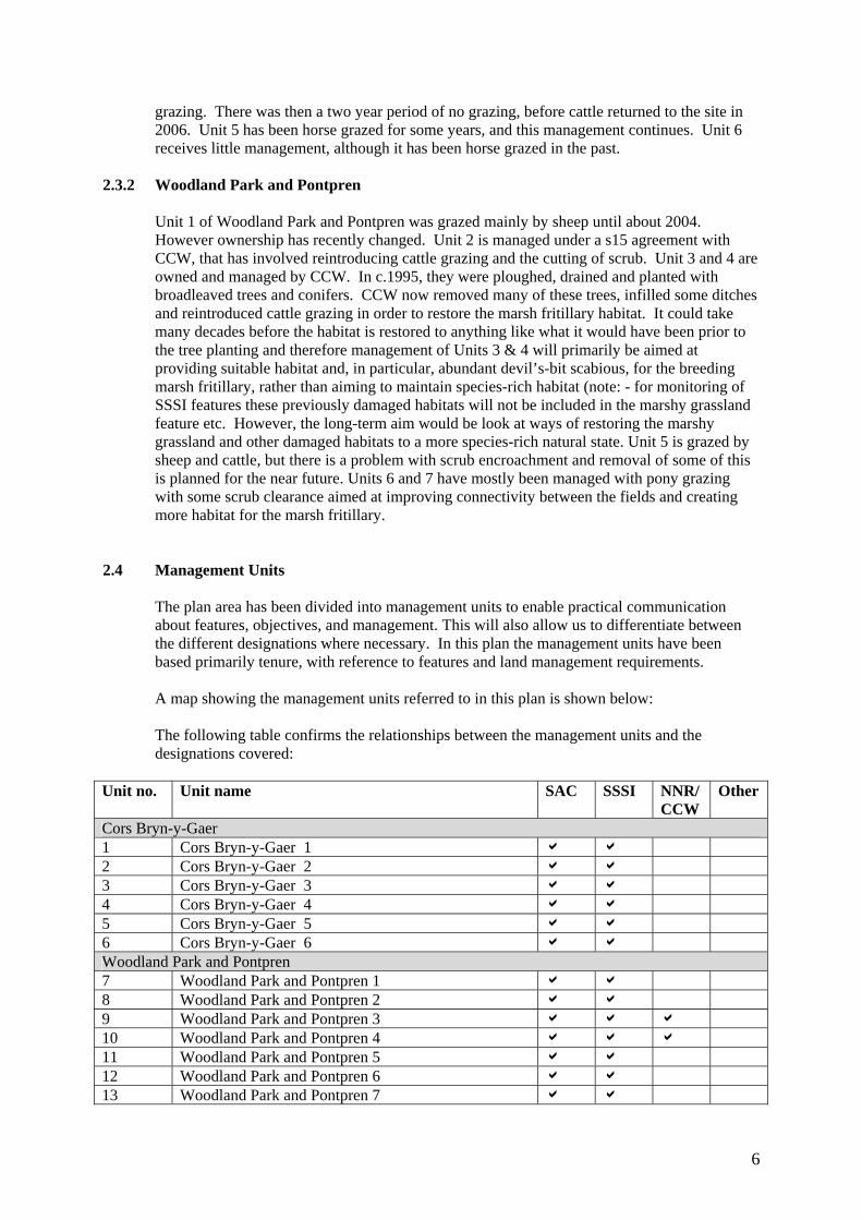
2.4 Management Units
The plan area has been divided into management units to enable practical communication about features, objectives, and management. This will also allow us to differentiate between the different designations where necessary. In this plan the management units have been based primarily tenure, with reference to features and land management requirements.
A map showing the management units referred to in this plan is shown below: The following table confirms the relationships between the management units and the designations covered:
Unit no. Unit name SAC SSSI NNR/
CCW Other
Cors Bryn-y-Gaer 1 Cors Bryn-y-Gaer 1 a a 2 Cors Bryn-y-Gaer 2 a a 3 Cors Bryn-y-Gaer 3 a a 4 Cors Bryn-y-Gaer 4 a a 5 Cors Bryn-y-Gaer 5 a a 6 Cors Bryn-y-Gaer 6 a a Woodland Park and Pontpren 7 Woodland Park and Pontpren 1 a a 8 Woodland Park and Pontpren 2 a a 9 Woodland Park and Pontpren 3 a a a 10 Woodland Park and Pontpren 4 a a a 11 Woodland Park and Pontpren 5 a a 12 Woodland Park and Pontpren 6 a a 13 Woodland Park and Pontpren 7 a a

7
3. THE SPECIAL FEATURES 3.1 Confirmation of Special Features Designated feature Relationships, nomenclature etc Conservation
Objective no. in part 4
SAC features Annex II species that are a primary reason for the selection of this site 1. Marsh fritillary butterfly Euphydryas (Eurodryas, Hypodryas) aurinia (EU Species Code: 1065)
1
SPA features Not applicable Ramsar features Not applicable SSSI features 2. Marshy grassland 2 3. Flush and Spring 3 4. Raised Bog 4 5. Species-rich neutral grassland 5 6. Acid Grassland 6 7. Semi-natural broadleaved woodland 7 3.2 Special Features and Management Units
This section sets out the relationship between the special features and each management unit. This is intended to provide a clear statement about what each unit should be managed for, taking into account the varied needs of the different special features.
All special features are allocated to one of seven classes in each management unit. These classes are:
Key Features KH - a ‘Key Habitat’ in the management unit, i.e. the habitat that is the main focus of management and monitoring effort, perhaps because of the dependence of a key species (see KS below). There will rarely be more than one Key Habitat in a unit. KS – a ‘Key Species’ in the management unit, often driving both the selection and management of a Key Habitat. Geo – an earth science feature that is the main focus of management and monitoring effort in a unit. Other Features Sym - habitats, species and earth science features that are of importance in a unit but are not the main focus of management or monitoring. These features will benefit from management for the key feature(s) identified in the unit. These may be classed as ‘Sym’ features because: a) they are present in the unit but are of less conservation importance than the key feature;
and/or b) they are present in the unit but in small areas/numbers, with the bulk of the feature in
other units of the site; and/or c) their requirements are broader than and compatible with the management needs of the key
feature(s).

8
Nm - an infrequently used category where features are at risk of decline within a unit as a result of meeting the management needs of the key feature(s), i.e. under Negative Management. These cases will usually be compensated for by management elsewhere in the plan, and can be used where minor occurrences of a feature would otherwise lead to apparent conflict with another key feature in a unit. Mn - Management units with no special feature present but which are of importance for management of features elsewhere on a site e.g. livestock over-wintering area included within designation boundaries. x – Features not present in the management unit.
The tables below sets out the relationship between the special features and management units identified in this plan: Background information on Blaen Cynon SAC Blaen Cynon SAC consists of two SSSIs: Cors Bryn y Gaer SSSI and Woodland Park and Pontpren SSSI. These sites are included in the Natura 2000 series for their population of marsh fritillary butterfly. The sites also host six SSSI features, namely marshy grassland, flush and spring, raised bog, species-rich neutral grassland, acid grassland and semi-natural broadleaved woodland. Marsh fritillary is the main focus for management in all units. In each unit, the key habitat is that most important for sustaining the marsh fritillary population. All other management is subordinate to this aim, but in fact most of the other habitat features can be managed in a way that sustains them whilst fulfilling their primary function of providing suitable habitat for marsh fritillaries. Cors Bryn-y-Gaer SSSI Management unit 1 2 3 4 5 6 SAC a a a a a a SSSI a a a a a a SAC features 1. Marsh fritillary butterfly KS KS KS KS KS KS SSSI features 2. Marshy grassland KH KH KH sym KH KH 3. Flush and Spring sym sym sym KH sym Sym 4. Raised Bog x sym sym x x Sym 5. Species-rich neutral grassland x x sym sym x X 6. Acid Grassland x x sym x x x 7. Semi-natural broadleaved woodland x x x x x x Woodland Park and Pontpren SSSI Management unit 7 8 9 10 11 12 13 SAC a a a a a a a SSSI a a a a a a a SAC features 1. Marsh fritillary butterfly KS KS KS KS KS KS KS SSSI features 2. Marshy grassland KH KH KH KH KH KH KH 3. Flush and Spring x x sym sym sym x sym 4. Raised Bog x x x x x x x 5. Species-rich neutral grassland x x x x x x x 6. Acid Grassland x x x sym x x sym 7. Semi-natural broadleaved woodland x x sym sym sym sym sym
9
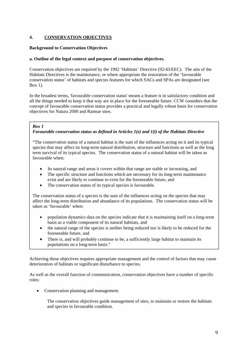
4. CONSERVATION OBJECTIVES Background to Conservation Objectives a. Outline of the legal context and purpose of conservation objectives.
Conservation objectives are required by the 1992 ‘Habitats’ Directive (92/43/EEC). The aim of the Habitats Directives is the maintenance, or where appropriate the restoration of the ‘favourable conservation status’ of habitats and species features for which SACs and SPAs are designated (see Box 1). In the broadest terms, 'favourable conservation status' means a feature is in satisfactory condition and all the things needed to keep it that way are in place for the foreseeable future. CCW considers that the concept of favourable conservation status provides a practical and legally robust basis for conservation objectives for Natura 2000 and Ramsar sites.
Achieving these objectives requires appropriate management and the control of factors that may cause deterioration of habitats or significant disturbance to species. As well as the overall function of communication, conservation objectives have a number of specific roles:
• Conservation planning and management.
The conservation objectives guide management of sites, to maintain or restore the habitats and species in favourable condition.
Box 1 Favourable conservation status as defined in Articles 1(e) and 1(i) of the Habitats Directive “The conservation status of a natural habitat is the sum of the influences acting on it and its typical species that may affect its long-term natural distribution, structure and functions as well as the long term survival of its typical species. The conservation status of a natural habitat will be taken as favourable when:
• Its natural range and areas it covers within that range are stable or increasing, and • The specific structure and functions which are necessary for its long-term maintenance
exist and are likely to continue to exist for the foreseeable future, and • The conservation status of its typical species is favourable.
The conservation status of a species is the sum of the influences acting on the species that may affect the long-term distribution and abundance of its populations. The conservation status will be taken as ‘favourable’ when:
• population dynamics data on the species indicate that it is maintaining itself on a long-term
basis as a viable component of its natural habitats, and • the natural range of the species is neither being reduced nor is likely to be reduced for the
foreseeable future, and • There is, and will probably continue to be, a sufficiently large habitat to maintain its
populations on a long-term basis.”

10
• Assessing plans and projects.
Article 6(3) of the ‘Habitats’ Directive requires appropriate assessment of proposed plans and projects against a site's conservation objectives. Subject to certain exceptions, plans or projects may not proceed unless it is established that they will not adversely affect the integrity of sites. This role for testing plans and projects also applies to the review of existing decisions and consents.
• Monitoring and reporting.
The conservation objectives provide the basis for assessing the condition of a feature and the status of factors that affect it. CCW uses ‘performance indicators’ within the conservation objectives, as the basis for monitoring and reporting. Performance indicators are selected to provide useful information about the condition of a feature and the factors that affect it.
The conservation objectives in this document reflect CCW’s current information and understanding of the site and its features and their importance in an international context. The conservation objectives are subject to review by CCW in light of new knowledge. b. Format of the conservation objectives There is one conservation objective for each feature listed in part 3. Each conservation objective is a composite statement representing a site-specific description of what is considered to be the favourable conservation status of the feature. These statements apply to a whole feature as it occurs within the whole plan area, although section 3.2 sets out their relevance to individual management units. Each conservation objective consists of the following two elements:
1 Vision for the feature 2 Performance indicators
As a result of the general practice developed and agreed within the UK Conservation Agencies, conservation objectives include performance indicators, the selection of which should be informed by JNCC guidance on Common Standards Monitoring1. There is a critical need for clarity over the role of performance indicators within the conservation objectives. A conservation objective, because it includes the vision for the feature, has meaning and substance independently of the performance indicators, and is more than the sum of the performance indicators. The performance indicators are simply what make the conservation objectives measurable, and are thus part of, not a substitute for, the conservation objectives. Any feature attribute identified in the performance indicators should be represented in the vision for the feature, but not all elements of the vision for the feature will necessarily have corresponding performance indicators. As well as describing the aspirations for the condition of the feature, the Vision section of each conservation objective contains a statement that the factors necessary to maintain those desired conditions are under control. Subject to technical, practical and resource constraints, factors which have an important influence on the condition of the feature are identified in the performance indicators.
1 Web link: http://www.jncc.gov.uk/page-2199

11
4.1 Conservation Objective for Feature 1:Marsh fritillary butterfly Euphydryas (Eurodryas, Hypodryas) aurinia (EU Species Code: 1065) Vision for feature 1 The vision for this feature is for it to be in a favourable conservation status, where all of the following conditions are satisfied:
• The site will contribute towards supporting a sustainable metapopulation of the marsh fritillary in the Penderyn/Hirwaun area. This will require a minimum of 50ha of suitable habitat, of which at least 10ha must be in good condition, although not all is expected to be found within the SAC. Some will be on nearby land within a radius of about 2km.
• The population will be viable in the long term, acknowledging the extreme population fluctuations of the species.
• A minimum of 30% of the total site area will be grassland suitable for supporting marsh fritillary. (As the total area of the SAC is 66.62 ha, 30% represents approximately 20 ha.)
• At least 40% of the suitable habitat (approximately 8 ha) must be in optimal condition for breeding marsh fritillary.
• Suitable marsh fritillary habitat is defined as stands of grassland where Succisa pratensis is present and where scrub more than 1 metre tall covers no more than 10% of the stands
• Optimal marsh fritillary breeding habitat will be characterised by grassland where the vegetation height is 10-20 cm, with abundant purple moor-grass Molinia caerulea, frequent “large-leaved” devil’s-bit scabious Succisa pratensis suitable for marsh fritillaries to lay their eggs and only occasional scrub. In peak years, a density of 200 larval webs per hectare of optimal habitat will be found across the site. (Fowles 20042)
Performance indicators for Feature 1 The performance indicators are part of the conservation objective, not a substitute for it. Assessment of plans and projects must be based on the entire conservation objective, not just the performance indicators. Performance indicators for feature condition Attribute Attribute rationale and other comments Specified limits A1. Density of larval webs
Larval web density in a ‘good’ year for marsh fritillary has been identified as a measurable performance indicator of the population. During peaks in the population cycle a density of 200 webs per hectare of suitable habitat is an appropriate target to set as defining favourable condition for strong populations. Wide fluctuations in abundance occur, with dramatic crashes in population size occurring every ten years or so. Recovery from these crashes may take 4 or 5 yrs.
Upper limit: not required Lower limit: in one year in six the number of larval webs is estimated to be 200 per hectare of Good Condition habitat.
Performance indicators for factors affecting the feature 2 Fowles AP (2004) Conservation objective for Marsh Fritillaries on marshy grassland. CCW internal document.

12
Factor Factor rationale and other comments Operational Limits F1. Extent and quality of the marshy grassland as habitat for marsh fritillary
The marsh fritillary is a highly localised and sedentary butterfly that inhabits unimproved Molinia grassland in the lowlands. It has an annual life-cycle and feeds as a larva on Succisa pratensis, especially on large-leaved plants that are growing amongst vegetation that is between 10 and 20 cms tall in late summer/autumn. The larvae over-winter communally amongst litter in such situations and the shelter provided by leaf litter and tussocks is considered to be important. Approximately 50ha of habitat is required to maintain the population in the long term, with at least 10ha is good condition. Not all is expected to be within the SAC. The operational limits reflect the minimum contribution of the Blaen Cynon SAC towards the favourable conservation status of the species in the Hirwaun/Penderyn area. Definition of Good Condition marsh fritillary habitat Grassland, with Molinia abundant where, for at least 80% of sampling points, the vegetation height is within the range of 10 to 20 cm (when measured using a Boorman’s disc) and Succisa pratensis is present within a 1 m radius. Scrub (>0.5 metres tall) covers no more than 10% of area Definition of Suitable marshy grassland Stands of grassland where Succisa pratensis is present at lower frequencies but still widely distributed (>5% of sampling points) throughout the habitat patch and in which scrub (>0.5 metre tall) covers no more than 25% of area. Alternatively, Succisa may be present at high density in close-cropped swards. [note: Available habitat is the total of Good Condition and Suitable habitat]
20 hectares of Available marshy grassland, including: 8 hectares of Good Condition marsh fritillary habitat Within Areas 1, 2, 3 and 4 50% of the vegetation meets the following criteria: Within a 50cm radius: Molinia is present AND The cover of Succisa is 10% or greater AND The vegetation height is between 10-20cm when measured using a Boorman’s disc. AND The cover of Juncus spp. does not exceed 50%
Other factors considered include – Owner/occupier objectives - the owners/occupiers of the land typically have an interest in securing some financial/agricultural benefit from the land. This return could be optimised by the agricultural improvement of the land, e.g. by installing new drainage, fertiliser application, or re-seeding; however these operations would cause significant long-term damage to the marsh fritillary habitat, namely the marshy grassland. Additionally unimproved marshy grasslands that are waterlogged for much of the

13
year are difficult to manage for many landowners, possibly resulting in a mixture of over- and under- grazing, with a tendency for scrub to spread. Because of the wet nature of some of the ground, some landowners may be reluctant to graze large stock. This factor will be controlled through management agreements and the SSSI legislation. An operational limit is not required. Weather conditions - Weather conditions have an effect on the breeding success of the marsh fritillary. In particular, poor weather conditions during the adult flight period will reduce opportunities for mating, egg-laying and dispersal from core areas. Weather conditions during early spring influence the rate of larval development of the marsh fritillary and the effects of the parasitic wasp (see below). This site is situated in an area of relatively high rainfall, which will has a large influence on the population dynamics of the marsh fritillary. This factor is outside the influence of the site manager and an operational limit is not required.
Parasites - The larvae of marsh fritillaries can be parasitised by species of braconid wasp of the Cotesia genus. The parasites can have good years and infect a large number of larval webs, causing a crash in the subsequent adult population of marsh fritillary. This factor is outside the influence of the site manager; and an operational limit is not required.
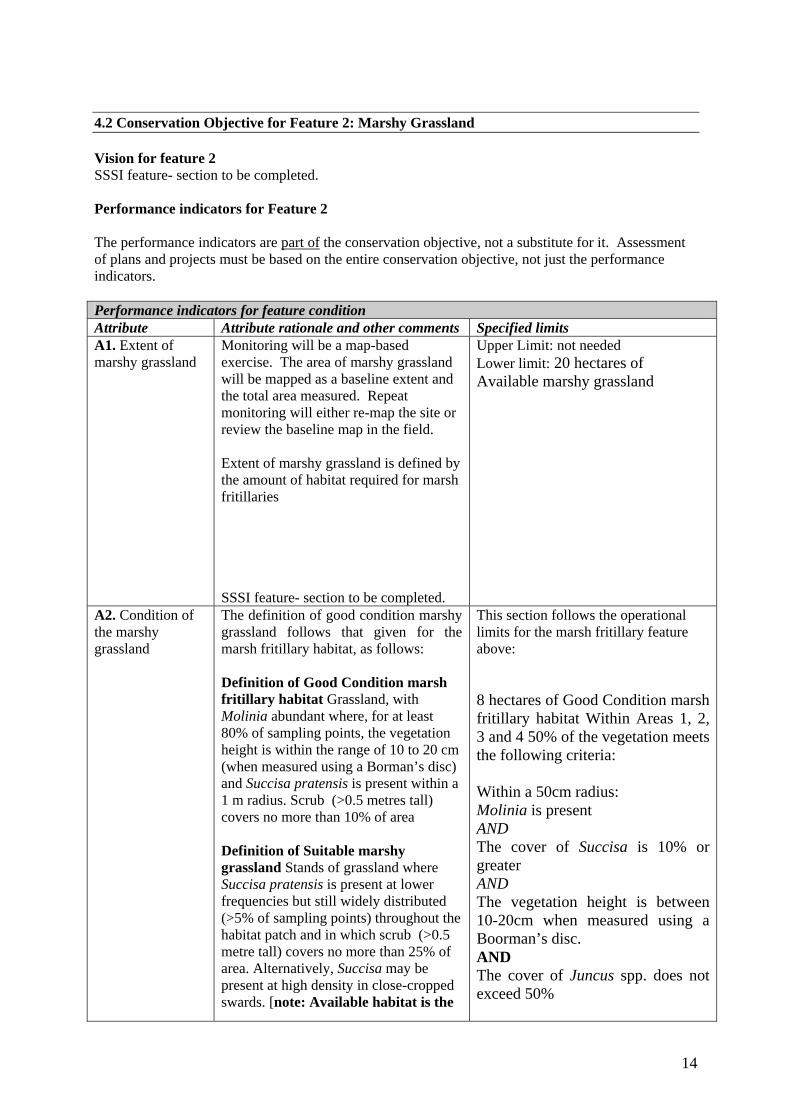
14
4.2 Conservation Objective for Feature 2: Marshy Grassland Vision for feature 2 SSSI feature- section to be completed. Performance indicators for Feature 2 The performance indicators are part of the conservation objective, not a substitute for it. Assessment of plans and projects must be based on the entire conservation objective, not just the performance indicators. Performance indicators for feature condition Attribute Attribute rationale and other comments Specified limits A1. Extent of marshy grassland
Monitoring will be a map-based exercise. The area of marshy grassland will be mapped as a baseline extent and the total area measured. Repeat monitoring will either re-map the site or review the baseline map in the field. Extent of marshy grassland is defined by the amount of habitat required for marsh fritillaries
SSSI feature- section to be completed.
Upper Limit: not needed Lower limit: 20 hectares of Available marshy grassland
A2. Condition of the marshy grassland
The definition of good condition marshy grassland follows that given for the marsh fritillary habitat, as follows: Definition of Good Condition marsh fritillary habitat Grassland, with Molinia abundant where, for at least 80% of sampling points, the vegetation height is within the range of 10 to 20 cm (when measured using a Borman’s disc) and Succisa pratensis is present within a 1 m radius. Scrub (>0.5 metres tall) covers no more than 10% of area Definition of Suitable marshy grassland Stands of grassland where Succisa pratensis is present at lower frequencies but still widely distributed (>5% of sampling points) throughout the habitat patch and in which scrub (>0.5 metre tall) covers no more than 25% of area. Alternatively, Succisa may be present at high density in close-cropped swards. [note: Available habitat is the
This section follows the operational limits for the marsh fritillary feature above: 8 hectares of Good Condition marsh fritillary habitat Within Areas 1, 2, 3 and 4 50% of the vegetation meets the following criteria: Within a 50cm radius: Molinia is present AND The cover of Succisa is 10% or greater AND The vegetation height is between 10-20cm when measured using a Boorman’s disc. AND The cover of Juncus spp. does not exceed 50%

15
total of Good Condition and Suitable habitat]
See Map 1 for the locations of Areas 1-4
Performance indicators for factors affecting the feature Factor Factor rationale and other comments Operational Limits SSSI feature- section to be completed.

16
4.3 Conservation Objective for Feature 3: Flush and Spring Vision for feature 3 SSSI feature- section to be completed. Performance indicators for Feature 3 The performance indicators are part of the conservation objective, not a substitute for it. Assessment of plans and projects must be based on the entire conservation objective, not just the performance indicators. Performance indicators for feature condition Attribute Attribute rationale and other comments Specified limits A1. Extent of flush and spring
Monitoring is likely to be a map-based exercise. The area of flush and spring will be mapped as a baseline extent and the total area measured. Repeat monitoring will either re-map the site or review the baseline map in the field. Flush and spring is defined as:
SSSI feature- section to be completed.
SSSI feature- section to be completed.
A2. Condition of the flush and spring
SSSI feature- section to be completed. SSSI feature- section to be completed.
Performance indicators for factors affecting the feature Factor Factor rationale and other comments Operational Limits SSSI feature- section to be completed.

17
4.4 Conservation Objective for Feature 4: Raised Bog Vision for feature 4 SSSI feature- section to be completed. Performance indicators for Feature 4 The performance indicators are part of the conservation objective, not a substitute for it. Assessment of plans and projects must be based on the entire conservation objective, not just the performance indicators. Performance indicators for feature condition Attribute Attribute rationale and other comments Specified limits A1. Extent of raised bog
Monitoring is likely to be a map-based exercise. The area of raised bog will be mapped as a baseline extent and the total area measured. Repeat monitoring will either re-map the site or review the baseline map in the field. Raised Bog is defined as:
SSSI feature- section to be completed.
SSSI feature- section to be completed.
A2. Condition of the raised bog
SSSI feature- section to be completed. SSSI feature- section to be completed.
Performance indicators for factors affecting the feature Factor Factor rationale and other comments Operational Limits SSSI feature- section to be completed.

18
4.5 Conservation Objective for Feature 5: Species-rich Neutral grassland Vision for feature 5 SSSI feature- section to be completed. Performance indicators for Feature 5 The performance indicators are part of the conservation objective, not a substitute for it. Assessment of plans and projects must be based on the entire conservation objective, not just the performance indicators. Performance indicators for feature condition Attribute Attribute rationale and other comments Specified limits A1. Extent of species-rich neutral grassland
Monitoring is likely to be a map-based exercise. The area of species-rich neutral grassland will be mapped as a baseline extent and the total area measured. Repeat monitoring will either re-map the site or review the baseline map in the field. Species-rich neutral grassland is defined as: SSSI feature- section to be completed.
SSSI feature- section to be completed.
A2. Condition of the species-rich neutral grassland
SSSI feature- section to be completed. SSSI feature- section to be completed.
Performance indicators for factors affecting the feature Factor Factor rationale and other comments Operational Limits SSSI feature- section to be completed.

19
4.6 Conservation Objective for Feature 6: Acid Grassland Vision for feature 6 SSSI feature- section to be completed. Performance indicators for Feature 6 The performance indicators are part of the conservation objective, not a substitute for it. Assessment of plans and projects must be based on the entire conservation objective, not just the performance indicators. Performance indicators for feature condition Attribute Attribute rationale and other comments Specified limits A1. Extent of acid grassland
Monitoring is likely to be a map-based exercise. The area of acid grassland will be mapped as a baseline extent and the total area measured. Repeat monitoring will either re-map the site or review the baseline map in the field. Acid grassland is defined as:
SSSI feature- section to be completed.
SSSI feature- section to be completed.
A2. Condition of the acid grassland
SSSI feature- section to be completed. SSSI feature- section to be completed.
Performance indicators for factors affecting the feature Factor Factor rationale and other comments Operational Limits SSSI feature- section to be completed.

20
4.7 Conservation Objective for Feature 7: Semi-natural Broadleaved Woodland Vision for feature 7 SSSI feature- section to be completed. Performance indicators for Feature 7 The performance indicators are part of the conservation objective, not a substitute for it. Assessment of plans and projects must be based on the entire conservation objective, not just the performance indicators. Performance indicators for feature condition Attribute Attribute rationale and other comments Specified limits A1. Extent of semi-natural broadleaved woodland
Monitoring is likely to be a map-based exercise. The area of semi-natural broadleaved woodland will be mapped as a baseline extent and the total area measured. Repeat monitoring will either re-map the site or review the baseline map in the field. Semi-natural broadleaved woodland is defined as:
SSSI feature- section to be completed.
SSSI feature- section to be completed.
A2. Condition of the semi-natural broadleaved woodland
SSSI feature- section to be completed. SSSI feature- section to be completed.
Performance indicators for factors affecting the feature Factor Factor rationale and other comments Operational Limits SSSI feature- section to be completed.

21
ASSESSMENT OF CONSERVATION STATUS AND MANAGEMENT REQUIREMENTS This part of the document provides: • A summary of the assessment of the conservation status of each feature. • A summary of the management issues that need to be addressed to maintain or restore each feature. 5.1 Conservation Status and Management Requirements of Feature 1: Marsh fritillary butterfly Euphydryas (Eurodryas, Hypodryas) aurinia (EU Species Code: 1065) Conservation Status of Feature 1 The SAC only includes the core of the marsh fritillary habitat (and hence core of the metapopulation). There are likely to be other small areas of habitat outside the SAC boundary which are used by the butterfly only occasionally, but which likely contribute to the long-term success of the metapopulation. Efforts should be made to encourage better management of these areas of land through schemes such as Tir Gofal or through specific grazing projects. Counts of marsh fritillary larval webs have been undertaken regularly since 1999. Numbers of webs have not achieved the levels required by the performance indicators. Monitoring has also concluded that there is insufficient good and available habitat. The assessment for both component SSSIs was that they were in unfavourable condition, and in this case we can give condition information at the unit level.. Cors Bryn-y-Gaer SSSI failed due to insufficient good quality marsh fritillary habitat. In addition, counts of marsh fritillary larval webs have not reached the required 200 per hectare of available habitat. Balancing grazing across the site with the right livestock is the key to successful management for this species. It involves using cattle or horses, and avoiding sheep. It also needs the level of grazing right to create the tussocky structure the butterfly requires, whilst avoiding over or under-grazing. Current assessments are: MU1 Unfavourable MU2 Unfavourable MU3 Unfavourable MU4 Unfavourable MU5 Unfavourable MU6 Unfavourable Woodland Park and Pontpren SSSI failed due to insufficient good quality marsh fritillary habitat. In addition, counts of marsh fritillary larval webs have not reached the required 200 per hectare of available habitat. Balancing grazing across the site with the right livestock is the key to successful management for this species. It involves using cattle or horses, and avoiding sheep. It also needs the level of grazing right to create the tussocky structure the butterfly requires, whilst avoiding over or under-grazing. Scrub encroachment is also a factor at this SSSI. Current assessments are: MU1 Unfavourable MU2 Unfavourable MU3 Unfavourable MU4 Unfavourable MU5 Unfavourable MU6 Unfavourable MU7 Unfavourable

22
Management Requirements of Feature 1 The current status of the feature overall is unfavourable. The principle reasons for this are inappropriate grazing, scrub invasion, inappropriate tree planting and past agricultural improvements in the management units. Without an appropriate grazing regime, the grassland will become rank and eventually turn to scrub and woodland. Conversely, overgrazing, or grazing by inappropriate stock (particularly sheep) will also lead to unwanted changes in species composition, through selective grazing, increased nutrient inputs and poaching. Balancing grazing is the single most important issue in the management of this site. There is now considerable experience in managing sites for marsh fritillaries in Wales, and the needs of the species are now reasonably well understood. Scrub encroachment is an issue, particularly on some wet grassland areas. A programme of scrub control is currently (2008) being undertaken, but it is likely that even with the ideal grazing management, a more or less continuous programme of scrub control will be required at this site. It is clear from aerial photographs and from discussions with landowners, that many areas that are currently covered in alder and willow woodland were formerly wet pasture. Therefore a long-term aim would be to investigate returning some of this to wet pasture that would likely increase the availability of marsh fritillary habitat. Parts of Woodland Park and Pontpren, notably units 3 and 4 have been subject to improvement in preparation for tree planting, including draining, planting with trees and use of fertiliser. These areas have a programme of scrub removal and cattle grazing in place, to restore the grassland to a condition where it can be used by marsh fritillaries. Some drains have been blocked, to restore the hydrology of the site. There are no known off-site factors, such as pollution, that are affecting the marsh fritillary to any significant extent, although there is still much industry in the locality. The two overwhelming issues of grazing and scrub encroachment would probably obscure any off-site issues. As management of the site improves off-site factors may become more apparent 5.2 Conservation Status and Management Requirements of Feature 2: Marshy Grassland Conservation Status of Feature 3 Unfavourable – refer to Feature 1 Management Requirements of Feature 3 SSSI feature- section to be completed. 5.3 Conservation Status and Management Requirements of Feature 3: Flush and Spring Conservation Status of Feature 3 Unfavourable – refer to Feature 1 Management Requirements of Feature 3

23
SSSI feature- section to be completed. 5.4 Conservation Status and Management Requirements of Feature 4: Raised Bog Conservation Status of Feature 4 Unfavourable – refer to Feature 1 Management Requirements of Feature 4 SSSI feature- section to be completed. 5.5 Conservation Status and Management Requirements of Feature 5: Species-rich Neutral Grassland Conservation Status of Feature 5 Unfavourable – refer to Feature 1 Management Requirements of Feature 5 SSSI feature- section to be completed. 5.6 Conservation Status and Management Requirements of Feature 6: Acid Grassland Conservation Status of Feature 6 Unfavourable – refer to Feature 1 Management Requirements of Feature 6 SSSI feature- section to be completed. 5.7 Conservation Status and Management Requirements of Feature 7: Semi-natural Broadleaved Woodland Conservation Status of Feature 7 Unfavourable – refer to Feature 1 Management Requirements of Feature 7 SSSI feature- section to be completed.

24
6. ACTION PLAN: SUMMARY This section takes the management requirements outlined in Section 5 a stage further, assessing the specific management actions required on each management unit. This information is a summary of that held in CCW’s Actions Database for sites, and the database will be used by CCW and partner organisations to plan future work to meet the Wales Environment Strategy targets for sites. Unit Number
CCW Database Number
Unit Name
Summary of Conservation Management Issues
Action needed?
1 000067 Management Unit 1
Feature of interest includes remnant, modified, strip of adjacent bog. Falls within larger management unit which comprises dry improved grassland. In recent years and subsequently the field has had hay taken from it and has been lightly grazed by horses. These horses rarely graze the area of modified bog (essentially wet heath and marshy grassland). Change of ownership recently but no contact made with new owners.
Yes
2 000516 Management Unit 2
In same ownership as Unit 1. Previously grazed by horses and cattle but no evidence or knowledge of grazing since change of ownership.
Yes
3 000521 Management Unit 3
Management agreement reached recently over the largest unit in the SAC, and summer grazing by cattle now more regular and controlled. in recent years the unit has been ungrazed or very lightly grazed by cattle but subsequent to this, the whole unit (and Unit 4) was quite closely grazed by cattle and sometimes by sheep.
No
4 000523 Management Unit 4
This unit is split from Unit 3 by ownership but is not physically separated from that unit and they are managed as one.
No
5 000524 Management Unit 5
Under management agreement with unit 6. Grazed by up to two horses which produces a closely grazed sward on the drier ground by the gate and a moderately grazed sward on the marshy ground which seems to produce a sward height in recent years that is good for breeding marsh fritillary.
No
6 000525 Management Unit 6
This unit is included in same management agreement as unit 5. This unit appears to have received less grazing in recent years than unit 5. Despite this, the sward height and quality of grassland is good for breeding marsh fritillary, but this may not be the case in future years if grazing levels remain low.
Yes
7 000526 Management Unit 1
Has changed ownership recently - current management not known, but previously grazed with larger field mainly by sheep
Yes
8 000527 Management Unit 2
Currently covered buy S15 agreement with emphasis on summer grazing by cattle. A problem with scrub encroachment and an on-going programme of scrub clearance in place.
Yes
25
Unit Number
CCW Database Number
Unit Name
Summary of Conservation Management Issues
Action needed?
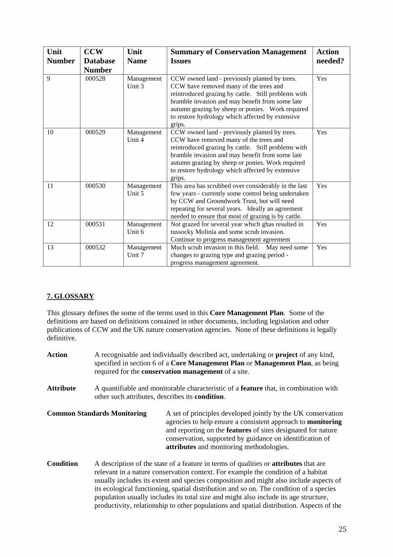
9 000528 Management Unit 3
CCW owned land - previously planted by trees. CCW have removed many of the trees and reintroduced grazing by cattle. Still problems with bramble invasion and may benefit from some late autumn grazing by sheep or ponies. Work required to restore hydrology which affected by extensive grips.
Yes
10 000529 Management Unit 4
CCW owned land - previously planted by trees. CCW have removed many of the trees and reintroduced grazing by cattle. Still problems with bramble invasion and may benefit from some late autumn grazing by sheep or ponies. Work required to restore hydrology which affected by extensive grips.
Yes
11 000530 Management Unit 5
This area has scrubbed over considerably in the last few years - currently some control being undertaken by CCW and Groundwork Trust, but will need repeating for several years. Ideally an agreement needed to ensure that most of grazing is by cattle.
Yes
12 000531 Management Unit 6
Not grazed for several year which ghas resulted in tussocky Molinia and some scrub invasion. Continue to progress management agreement
Yes
13 000532 Management Unit 7
Much scrub invasion in this field. May need some changes to grazing type and grazing period - progress management agreement.
Yes
7. GLOSSARY This glossary defines the some of the terms used in this Core Management Plan. Some of the definitions are based on definitions contained in other documents, including legislation and other publications of CCW and the UK nature conservation agencies. None of these definitions is legally definitive. Action A recognisable and individually described act, undertaking or project of any kind,
specified in section 6 of a Core Management Plan or Management Plan, as being required for the conservation management of a site.
Attribute A quantifiable and monitorable characteristic of a feature that, in combination with
other such attributes, describes its condition. Common Standards Monitoring A set of principles developed jointly by the UK conservation
agencies to help ensure a consistent approach to monitoring and reporting on the features of sites designated for nature conservation, supported by guidance on identification of attributes and monitoring methodologies.
Condition A description of the state of a feature in terms of qualities or attributes that are
relevant in a nature conservation context. For example the condition of a habitat usually includes its extent and species composition and might also include aspects of its ecological functioning, spatial distribution and so on. The condition of a species population usually includes its total size and might also include its age structure, productivity, relationship to other populations and spatial distribution. Aspects of the

26
habitat(s) on which a species population depends may also be considered as attributes of its condition.
Condition assessment The process of characterising the condition of a feature with
particular reference to whether the aspirations for its condition, as expressed in its conservation objective, are being met.
Condition categories The condition of feature can be categorised, following condition
assessment as one of the following3: Favourable: maintained; Favourable: recovered;
Favourable: un-classified Unfavourable: recovering; Unfavourable: no change; Unfavourable: declining; Unfavourable: un-classified Partially destroyed; Destroyed. Conservation management Acts or undertaking of all kinds, including but not necessarily limited
to actions, taken with the aim of achieving the conservation objectives of a site. Conservation management includes the taking of statutory and non-statutory measures, it can include the acts of any party and it may take place outside site boundaries as well as within sites. Conservation management may also be embedded within other frameworks for land/sea management carried out for purposes other than achieving the conservation objectives.
Conservation objective The expression of the desired conservation status of a feature,
expressed as a vision for the feature and a series of performance indicators. The conservation objective for a feature is thus a composite statement, and each feature has one conservation objective.
Conservation status A description of the state of a feature that comprises both its condition and
the state of the factors affecting or likely to affect it. Conservation status is thus a characterisation of both the current state of a feature and its future prospects.
Conservation status assessment The process of characterising the conservation status of a
feature with particular reference to whether the aspirations for it, as expressed in its conservation objective, are being met. The results of conservation status assessment can be summarised either as ‘favourable’ (i.e. conservation objectives are met) or unfavourable (i.e. conservation objectives are not met). However the value of conservation status assessment in terms of supporting decisions about conservation management, lies mainly in the details of the assessment of feature condition, factors and trend information derived from comparisons between current and
3 See JNCC guidance on Common Standards Monitoring http://www.jncc.gov.uk/page-2272

27
previous conservation status assessments and condition assessments.
Core Management Plan A CCW document containing the conservation objectives for a site
and a summary of other information contained in a full site Management Plan.
Factor Anything that has influenced, is influencing or may influence the condition of a
feature. Factors can be natural processes, human activities or effects arising from natural process or human activities, They can be positive or negative in terms of their influence on features, and they can arise within a site or from outside the site. Physical, socio-economic or legal constraints on conservation management can also be considered as factors.
Favourable condition See condition and condition assessment Favourable conservation status See conservation status and conservation status
assessment.4 Feature The species population, habitat type or other entity for
which a site is designated. The ecological or geological interest which justifies the designation of a site and which is the focus of conservation management.
Integrity See site integrity Key Feature The habitat or species population within a management unit that is the primary focus
of conservation management and monitoring in that unit. Management Plan The full expression of a designated site’s legal status, vision, features,
conservation objectives, performance indicators and management requirements. A complete management plan may not reside in a single document, but may be contained in a number of documents (including in particular the Core Management Plan) and sets of electronically stored information.
Management Unit An area within a site, defined according to one or more of a range of criteria,
such as topography, location of features, tenure, patterns of land/sea use. The key characteristic of management units is to reflect the spatial scale at which conservation management and monitoring can be most effectively organised. They are used as the primary basis for differentiating priorities for conservation management and monitoring in different parts of a site, and for facilitating communication with those responsible for management of different parts of a site.
Metapopulation A group of distinct populations of a species, separated by areas of either
unoccupied, or unsuitable, habitat. These populations can support one another, so that when one population becomes extinct, the species can recolonise from a nearby population.
Monitoring An intermittent (regular or irregular) series of observations in time, carried out to
show the extent of compliance with a formulated standard or degree of deviation from
4 A full definition of favourable conservation status is given in Section 4.

28
an expected norm. In Common Standards Monitoring, the formulated standard is the quantified expression of favourable condition based on attributes.
Operational limits The levels or values within which a factor is considered to be acceptable in
terms of its influence on a feature. A factor may have both upper and lower operational limits, or only an upper limit or lower limit. For some factors an upper limit may be zero.
Performance indicators The attributes and their associated specified limits, together with
factors and their associated operational limits, which provide the standard against which information from monitoring and other sources is used to determine the degree to which the conservation objectives for a feature are being met. Performance indicators are part of, not the same as, conservation objectives. See also vision for the feature.
Plan or project Project: Any form of construction work, installation, development or other
intervention in the environment, the carrying out or continuance of which is subject to a decision by any public body or statutory undertaker. Plan: a document prepared or adopted by a public body or statutory undertaker, intended to influence decisions on the carrying out of projects. Decisions on plans and projects which affect Natura 2000 and Ramsar sites are subject to specific legal and policy procedures.
Site integrity The coherence of a site’s ecological structure and function, across its whole area, that
enables it to sustain the habitat, complex of habitats and/or the levels of populations of the species for which it is designated.
Site Management Statement (SMS) The document containing CCW’s views about the management
of a site issued as part of the legal notification of an SSSI under section 28(4) of the Wildlife and Countryside Act 1981, as substituted.
Special Feature See feature. Specified limit The levels or values for an attribute which define the degree to which the
attribute can fluctuate without creating cause for concern about the condition of the feature. The range within the limits corresponds to favourable, the range outside the limits corresponds to unfavourable. Attributes may have lower specified limits, upper specified limits, or both.
Unit See management unit. Vision for the feature The expression, within a conservation objective, of the aspirations
for the feature concerned. See also performance indicators. Vision Statement The statement conveying an impression of the whole site in the state that is
intended to be the product of its conservation management. A ‘pen portrait’ outlining the conditions that should prevail when all the conservation objectives are met. A description of the site as it would be when all the features are in favourable condition.