Embed Size (px)
Citation preview
BIM – Record File Standards
BIM – Record File Standards
BIM Record File Standards revision letter C revision date August 2014 © x-Spatial LLC, 2014 status: Published
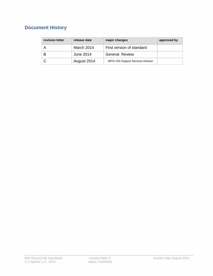
Document History
revision letter release date major changes approved by
A March 2014 First version of standard
B June 2014 General Review
C August 2014 IMTG GIS Support Services Division

BIM Record file Standards revision letter C revision date August 2014 © x-Spatial LLC, 2014 Status: Published
Table of Contents
About this book ...................................................................................................................................... 1
Relation to existing standards ......................................................................................................... 1
Who should read this book ............................................................................................................. 1
How this book is organized ............................................................................................................. 1
Related documents ......................................................................................................................... 2
BIM Model organization .................................................................................................................. 2
Abbreviations .................................................................................................................................. 3
Standards in use at LAWA .................................................................................................................... 4
LAWA Standards ............................................................................................................................ 4
National and International Standards ............................................................................................. 5
Compliance ..................................................................................................................................... 5
Request of Variance ....................................................................................................................... 5
Definitions ....................................................................................................................................... 6
Introduction ............................................................................................................................................ 8
Interoperability................................................................................................................................. 8
Central Files .................................................................................................................................... 8
Coordinates ..................................................................................................................................... 9
Referencing file linking using Manage Links ................................................................................... 9
View Filters ...................................................................................................................................... 9
Families ......................................................................................................................................... 10
Visibility Graphics .......................................................................................................................... 10
Object Styles ................................................................................................................................. 10
View Templates ............................................................................................................................ 10
Scope Boxes ................................................................................................................................. 10
Revit Model Requirements and Warnings .................................................................................... 11
Data Segregation .................................................................................................................................. 12
General Principles ......................................................................................................................... 12
Example of Data Segregation: ...................................................................................................... 12
Folder Structure and File Naming Conventions ............................................................................... 13
Introduction ................................................................................................................................... 13
Project Folder Structure ................................................................................................................ 13
General Naming Conventions ....................................................................................................... 13
BIM Record File Naming Convention ........................................................................................... 14
Examples of Record file naming: ......................................................................................... 14
Discipline (2 char) ................................................................................................................ 15
Project zone Codes (examples) ........................................................................................... 16

BIM Record file Standards revision letter C revision date August 2014 © x-Spatial LLC, 2014 Status: Published
Revit Version (examples) ..................................................................................................... 16
Project Browser and View Organization for Record files ................................................................ 17
Sheet View Organization .............................................................................................................. 17
Sheet reference number: .............................................................................................................. 18
Example of a sheet reference number: ................................................................................ 18
Discipline designator ............................................................................................................ 19
Sheet Type Designators ....................................................................................................... 19
Sheet description: ......................................................................................................................... 20
Example of sheet organization and naming: ........................................................................ 20

BIM Record file Standards revision letter B revision date June 2014 © x-Spatial LLC, 2014 Status: Published page 1 of 20
About this book
The intent of these guidelines is to provide a framework for all Revit as-built deliverables, including:
Revit Architecture
Revit MEP
Revit Structure
This guide is NOT intend to be a Revit tutorial, but rather assumes that the user has a sufficient level of proficiency to comprehend the requirements outlined in this guide.
By using these standards, LAWA will achieve a standardized approach to spatial data management and related record document(s) that will bring many benefits to both the organization and its staff. These benefits include, but are not limited to:
consistent and more reliable data that will lead to more informed decision making
closer integration with other LAWA information systems and LAWA spatial data users
portability of staff skills
greater interoperability with organizations outside of LAWA
Relation to existing standards
The LAWA standards have adapted and extended a series of BIM standards already developed or approved by USACE_CAD-BIM_Technology Center and the National BIM standard (United States):
Who should read this book
These BIM standards are for use in-house by LAWA and for architects, engineers, surveys and consultants delivering information to LAWA. The purpose of these standards is to ensure all relevant BIM data files and related geospatial datasets meet LAWA standards.
How this book is organized
After the introduction, this book contains the following sections:
Data Segregation
Folder Structure and File Naming Conventions
Project Browser and View Organization for Record Files

BIM Record file Standards revision letter B revision date June 2014 © x-Spatial LLC, 2014 Status: Published page 2 of 20
Related documents
CAD, GIS, Survey, Metadata and EDI standards along with other documentation related to these standards are available on the LAWA website. LAWA Standard Documents and
Guidelines
BIM Model organization
Revit files (.rvt) contain all views (model based or sheet based) in the same file.
Using agreed upon conventions makes it easy to identify the:
Discipline
Project number
Project Zone (where applicable)
Model description
Revit Version
These guidelines focus primarily on adaptation of standards for practical and efficient application of BIM, particularly at the handover (Record - As-Built) stage of a project.
The objectives are:
To maximize efficiency through adopting a coordinated and consistent approach to working in Revit Models.
To define the standards, settings and best practices that ensures delivery of high quality data and uniform drawing output.
To ensure that digital Revit files are structured correctly to enable efficient data sharing within LAWA.
RevitistheBIMsoftwareofchoicewithinLAWATheRevitsoftwareversionwillbedeterminedandenforcedperprojectRevit,recordfilesmustreflecttheAs‐Builtconditions

BIM Record file Standards revision letter B revision date June 2014 © x-Spatial LLC, 2014 Status: Published page 3 of 20
Abbreviations
AEGIS - Airport Enterprise Geographical Information System
ANSI - American National Standards Institute
BIM - Building Information Modeling
CAD - Computer Aided Design and Drafting
CPPE - Capital Planning, Programming and Engineering
CSDGM - Content Standard for Digital Geospatial Metadata
DDMS - Document & Drawing Management System
EDI - Electronic Data Interchange
FAA - Federal Aviation Administration
FGDC - The Federal Geographic Data Committee
GIS - Geographic Information System
GISSSD - GIS Support Services Division
IMTG - Information Management Technology Group
ISO - International Organization for Standardization
LAWA - Los Angeles World Airports
LAX - Los Angeles International Airport
ONT - Ontario Airport
PMD - Palmdale Airport
SDSFIE - Spatial Data Standards for Facilities, Infrastructure, and Environment
VNY - Van Nuys Airport

BIM Record file Standards revision letter B revision date June 2014 © x-Spatial LLC, 2014 Status: Published page 4 of 20
Standards in use at LAWA
LAWA Standards
This section provides an overview of LAWA specific standards, plus related federal, local, and national standards. LAWA standards have been created to improve productivity and reliable information exchange through the full life-cycle of geospatial data, CAD and BIM files along with related documents.
LAWA Metadata Standards
Metadata is structured information that describes, explains, locates, or otherwise makes it easier to retrieve, use, or manage an information resource. Metadata is often called data about data or information about information.
LAWA CAD Standards
The LAWA CAD standards are based largely on the AIA CAD Layer Guidelines and the National CAD Standards (NCS), adapted where necessary to suit LAWA-specific requirements.
LAWA GIS Standards
The LAWA GIS standards are directly based on the ANSI Spatial Data Standard for Facilities Infrastructure and Environment (SDSFIE), Release 2.60, extended in certain areas to handle specific information relevant to LAWA. GIS Standards for LAWA Projects presents the most important aspects of SDSFIE as it applies to LAWA.
LAWA Survey Standards
The LAWA Survey and Remote Sensing Standards are based on requirements laid out in Airport Circulars published by the FAA, adapted where necessary to suit LAWA-specific requirements.
LAWA BIM Standards
These guidelines focus primarily on adaptation of standards for practical and efficient application of BIM, particularly at the handover (Record - As-Built) stage of a project. Based on USACE_CAD-BIM_Technology Center: version 1.1 and National BIM standard (United States): version2.
LAWA EDI (Electronic Data Interchange) Standards
This Standard provides a framework for all data requests and all hard copy or electronic data submittals to or from LAWA, thus ensuring a streamlined data exchange process.
ThesestandardsalongwithotherdocumentationrelatedtothesestandardsareavailableontheLAWAwebsite. LAWA Standard Documents and Guidelines

BIM Record file Standards revision letter B revision date June 2014 © x-Spatial LLC, 2014 Status: Published page 5 of 20
National and International Standards
USACE_CAD-BIM_Technology Center: version 1.1
National BIM standard (United States): version2
NCS – United States National CAD Standard: version 5
Compliance
Having timely up to date, accurate, fully compliant data available to the LAWA community forms an integral part of planning within any project. The aim of these standards is to ensure a smooth data transfer of information into the LAWA geospatial data base and efficient data maintenance through the complete data lifecycle. Accordingly, the terms and conditions of a LAWA contract require compliance with these standards.
Failure to comply with these standards may result in organizations being back-charged for any financial costs incurred by LAWA for rectifying inconsistencies and errors
The individual or organization submitting the files is also responsible for ensuring that all links between non-graphic data and graphic data, and all relationships between database tables, shall be preserved or automatically reconstructed when data is transferred to the LAWA GIS environment.
Request of Variance
Compliance with the LAWA standards and data deliverables demands are the cornerstone of achieving trustworthy and relevant data.
Suggestions for improvements or extensions to these standards and demands are encouraged, to meet unforeseen requirements and as a way to improve effectiveness and clarify any ambiguities; any such deviation must be approved by LAWA, in advance and in writing. . Requests need to be submitted on the “Request for variance” form, this form along with other documentation related to these standards are available on the LAWA website. LAWA Standard Documents and Guidelines
SeeEDIforstandardsgoverningdatasubmittedtoLAWA,thisalongwithotherdocumentationrelatedtothesestandardsareavailableontheLAWAwebsite.LAWA Standard Documents and Guidelines

BIM Record file Standards revision letter B revision date June 2014 © x-Spatial LLC, 2014 Status: Published page 6 of 20
Definitions
The following terms define the concepts of BIM and data structures used in this guideline.
Definitions
BIM Building Information Modelling (BIM): the creation and use of coordinated, internally consistent, computable information about a project in design and construction. In this document, specifically related to Revit files.
Views/ Output files
A generated rendition of graphical or non-graphical information (a plan, section, elevation, schedule, or other views of a project).
Central Files The central file is the source of the Record (as-built) file
The Central file is created the first time you save the project after sharing it. This file stores the current ownership information for all the Worksets in the project. The central file acts as the distribution point for publishing work to the rest of the team. All users should save their own local copies of the file, work locally, and then save changes back to the central file for other users to see their work.
Worksets Autodesk Revit projects can be subdivided into Worksets. A Workset is a collection of building elements (such as walls, doors, floors, stairs, etc.) in the building. In the Autodesk Revit project, users have the option of checking out entire worksets or individual elements in a workset. All other team members may view these elements or Worksets, but are unable to change them, preventing possible conflicts in the project.
View Types Defines some graphics properties, such as a reference label and tags for elevations, callouts, or sections. It can also specify a view template to apply to a new view, and whether template updates should be applied to existing views.
Coordinates There are two coordinate systems in a Revit project: project internal and shared. Each system has essential features and limitations.
Project Internal Coordinate System
Every Revit project has an internal coordinate system referred to in several places as Project. The project coordinate system cannot be changed.
Shared Coordinates
The shared coordinate system consists of a single origin and true north orientation which can be synchronized between models and even AutoCAD drawings.
View Templates A view template is a collection of view properties, such as view scale, discipline, detail level, and visibility settings. Use view templates to apply standard settings to views. View templates can help to ensure adherence to office standards and achieve consistency across construction document
sets.
BIM Record file Standards revision letter B revision date June 2014 © x-Spatial LLC, 2014 Status: Published page 7 of 20
Definitions
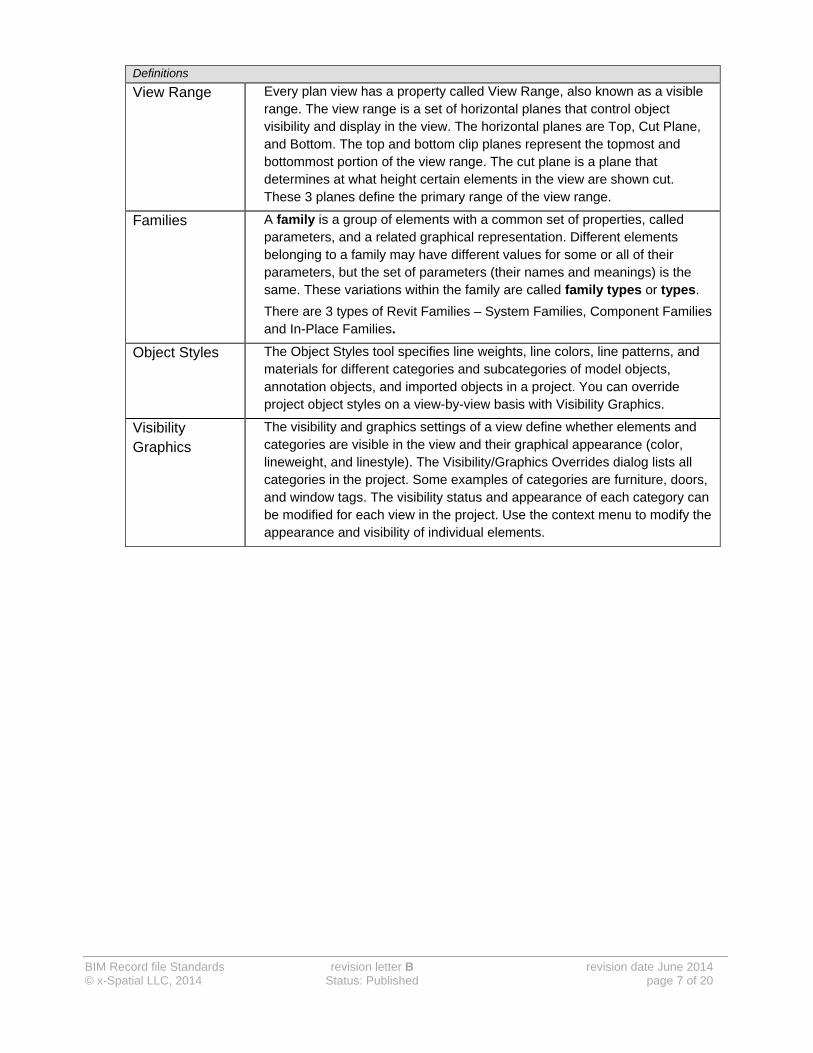
View Range Every plan view has a property called View Range, also known as a visible range. The view range is a set of horizontal planes that control object visibility and display in the view. The horizontal planes are Top, Cut Plane, and Bottom. The top and bottom clip planes represent the topmost and bottommost portion of the view range. The cut plane is a plane that determines at what height certain elements in the view are shown cut. These 3 planes define the primary range of the view range.
Families A family is a group of elements with a common set of properties, called parameters, and a related graphical representation. Different elements belonging to a family may have different values for some or all of their parameters, but the set of parameters (their names and meanings) is the same. These variations within the family are called family types or types.
There are 3 types of Revit Families – System Families, Component Families and In-Place Families.
Object Styles The Object Styles tool specifies line weights, line colors, line patterns, and materials for different categories and subcategories of model objects, annotation objects, and imported objects in a project. You can override project object styles on a view-by-view basis with Visibility Graphics.
Visibility Graphics
The visibility and graphics settings of a view define whether elements and categories are visible in the view and their graphical appearance (color, lineweight, and linestyle). The Visibility/Graphics Overrides dialog lists all categories in the project. Some examples of categories are furniture, doors, and window tags. The visibility status and appearance of each category can be modified for each view in the project. Use the context menu to modify the appearance and visibility of individual elements.

BIM Record file Standards revision letter B revision date June 2014 © x-Spatial LLC, 2014 Status: Published page 8 of 20
Introduction
To achieve technical excellence and a successful outcome to a project, it is essential that explicit attention is given to the management, display and quality of the Record (As-Built) data.
Below are a number of key principles that will facilitate efficient, high quality work products.
Whensubmittingrecordfiles,theconsultingcompanymustclearlydocumentwhathasbeenmodeledandwhatlevelofdevelopment(LOD)hasbeenprovided
All outstanding warnings and issues (that can be) must be resolved.
− Any warnings that cannot be resolved must be detailed in the project submission documentation.
All issues in Coordination Review within Revit should be resolved.
All un-hosted / orphaned families should be reconciled onto the appropriate host.
Record (As-Built) BIM Project Review should take place to ensure model integrity.
Record model quality control procedures must be performed and documented
Separate models submitted for each building and each disciplines (mechanical, electrical, plumbing etc…). Further divide models within a discipline if the files sizes become too big or slow to operate.
Interoperability
Interoperability between software products is of paramount importance for LAWA. Whether it is output to 2D CAD for subsequent drawing production or output for GIS visualization or analysis, the preparation and methods adopted to compose the as-built BIM will ultimately determine its successful interoperability to other software packages and technologies
Central Files
The main central files from each discipline shall be supplied to the owner as the final record model. All essential linked models including Revit files, CAD files and Point Clouds must be provided as their own separate central files.
Files linked for the purpose of internal reference requirements and not needed for final record file shall be unlinked and removed using the tools within Revit.
ThecentralfileisthesourceoftheRecord(As‐Built)file

BIM Record file Standards revision letter B revision date June 2014 © x-Spatial LLC, 2014 Status: Published page 9 of 20
Coordinates
All Revit models supplied shall reference true coordinates and use the Revit shared coordinates functionality for all linked files that require coordinates with the final record files.
When referencing, Revit or CAD files, the models must be positioned relative to the agreed surveyed and benchmarked project points and also reference a Shared Coordinate system dictated in Revit.
All points must be specified in the mapping service tab of the Location dialog box within Revit.
modelsmustbepositionedrelativetotheagreedprojectpoints
Shared Coordinates
The shared coordinate system consists of a single origin and true north orientation which can be synchronized between models and any AutoCAD drawings.
Referencing file linking using Manage Links
Some projects may require that models of single buildings are split into multiple files and linked back together in order to maintain manageable model file size.
Revit models must always be kept separate by discipline, e.g. architecture, structure, mechanical, electrical, piping and plumbing.
Each discipline in a Revit model shall be in its own unique workset.
Ensure that all .RVT and .DWG or any other required files are linked and not imported into the Revit file.
All Linked files must be supplied as a part of the record file deliverables
Remove all links to irrelevant or extraneous files that are not required as record file deliverables.
View Filters
View Filters are used in Revit to provide a higher level of control of view details, whether for graphic representation or hiding of objects. All systems used in Revit shall have filters applied to their categories for an added level of control.

BIM Record file Standards revision letter B revision date June 2014 © x-Spatial LLC, 2014 Status: Published page 10 of 20
Families
All Revit families must follow a logical naming convention; this is true for all system, component and in-place families.
All families will be categorized in a correct Revit category. No families shall be reference as “generic model” only.
All Hosted Families, in linked models shall be linked and reconciled if orphaned.
Visibility Graphics
Objects in views shall be shown or hidden by category, view filter, or by workset.
Hide objects at the category level, by using visibility graphics, filters or worksets.
Only use element hiding when necessary.
Object Styles
Linetype, lineweight and drafting standards shall be set in the object styles dialog box to conform to the LAWA CAD standards.
View Templates
All views in the Revit model created for final sheets shall be controlled by a View Template applied to the view in a manner that is consistent with a logical naming convention.
These templates shall be created by the consultant within their own central file.
Scope Boxes
Scope Boxes shall be used on all views that require the division of a view layout and then applied to all levels that require the same division.
Manual editing of the crop area is not acceptable.
All Scope Boxes separating areas shall have appropriate naming conventions and matchlines attached.

BIM Record file Standards revision letter B revision date June 2014 © x-Spatial LLC, 2014 Status: Published page 11 of 20
Revit Model Requirements and Warnings
The following represents some examples of the Revit model requirements and possible warnings requiring attention and correction.
Overlapping of design elements (especially walls and room boundaries).
All floors are subdivided by space/room.
Every space/room has a name and a number, including all shafts and stairs.
LAWA room numbering conventions must be applied. Refer to FM@LAWA Facilities Management Handbook Building Space Naming Convention.
There is only one space instance per space, per discipline, no duplicates.
− Note: Some engineering spaces may fit exactly on top of linked architectural models
All engineering spaces are defined level to level
Plenums are defined; as a separate engineering spaces.
Reconcile all orphaned families (resulting from using “copy/paste”. (in Revit this is known as reconciling an orphaned family)
All mechanical systems are defined (every element belongs to a system). This can be verified using the Revit MEP system browser.
Sidewall diffusers are placed in defined spaces and attached to corresponding walls.
Ensure that all objects in a Revit project are placed in the correct workset.
Ensure that all mechanical zones are defined.
Ensure that there are no unassigned components (View/User Interface/System Browser).

BIM Record file Standards revision letter B revision date June 2014 © x-Spatial LLC, 2014 Status: Published page 12 of 20
Data Segregation
General Principles
The project BIM models should be constructed in a manner that allows LAWA to view and use the model without recourse to complicated introductions to the project methodology.
The methods adopted for data segregation shall take into account, and be agreed with LAWA.
The following practices shall be followed:
No more than one building shall be modeled in a single file. Further divide within a building if the model file becomes too big or slow to operate.
A model file shall contain data from one discipline only (although exceptions may apply for Building Services where multiple disciplines converge).
Further segregation of the geometry may be required to ensure that model files remain workable on available hardware.
Where multiple buildings (models) make up a single project, a site model should be considered, where all architectural models in the project are linked together using shared coordinates.
Example of Data Segregation:
Discipline Segregation
Architecture level by level
Structure Major geometry splits, such as east-wing or west-wing, or movement joints between sections. All items shall be separated by their levels dictated by Revit.
Mechanical Construction joints such as podium and tower. All mechanical systems shall be separated by levels.
Electrical All distribution systems shall be separated by their levels.
Civil Document sets Work allocation such as core, shell and interiors
Data segregation in the Revit Model must show/highlight/identify those points of integration across floors when exported to 2D plans (DWG). For those systems that span floors, all controls/valves/switches et cetera that isolate floors from those systems must be identified and highlighted in both the model and the dwg

BIM Record file Standards revision letter B revision date June 2014 © x-Spatial LLC, 2014 Status: Published page 13 of 20
Folder Structure and File Naming Conventions
Introduction
Even with BIM systems, the importance of model and file naming convention cannot be overstated and a clear and concise naming convention is critical to the successful identification of BIM data.
A naming convention is required to ensure that all files created on a project can be identified quickly, accurately and without ambiguity. Ownership, location, type of file and a unique number are all of paramount importance when identifying the content of a BIM file.
The following paragraphs provide the necessary guidelines for a model naming convention suitable for multi-discipline and multi-functional project.
Project Folder Structure
Record files will be submitted to LAWA within a clearly designated set of folders.
Where a project comprises of a number of separate elements such as multiple buildings, zones or areas, the BIM structure shall be maintained within a set of designated sub-folders representing the various project elements.
All record files shall be held within the standard project folder structure.
No spaces are to be used in the folder naming as this can potentially interfere with certain file management tools and collaboration across the internet.
General Naming Conventions
Use only letters A-Z, hyphen, underscore and numbers 0-9 for all fields.
All fields shall be separated by a hyphen character “-” Do NOT use spaces.
Within a field, either CamelCase or an underscore “_” shall be used instead of a space to separate words.
A single period character "." shall be used to separate the file name from the extension. This character should not be used anywhere else in the file name.
The file extension shall not be amended or deleted.
The scheme for zone and level sub-division shall be agreed with LAWA at the outset of the project.

BIM Record file Standards revision letter B revision date June 2014 © x-Spatial LLC, 2014 Status: Published page 14 of 20
BIM Record File Naming Convention
The following naming conventions must be used for all Record files
BIM Record file naming convention
Discipline Project zone Revit version
- - - -
Project Model Description
BIM Record file names
component length comment
Discipline designator The discipline designator for a file name identifies the discipline. Where a file applies to a high-level discipline with a single-letter code, the second letter is replaced with a hyphen.
Allowable characters for the discipline designator in sheet files are listed below.
Project code Project codes are developed by LAWA or their authorized representative and are provided to the contractors for each project. Agreed project codes must be used in all LAWA files, to guarantee unique, consistent file names.
Project zone These codes are defined per project, and generally identify a building, zone or area.
Model Description Descriptive field to define the type of data portrayed in the file. Avoid repeating information codified in other fields. Can be used to describe any part of the previous fields, or to further clarify any other aspect of the contained data.
Revit Version Version of Revit in which the file was created
Examples of Record file naming:
A-1282-ZA-BuildingCore-R12 (includes a Project zone)
A-1282-BuildingCore-R12 (Project zone is not applicable)

BIM Record file Standards revision letter B revision date June 2014 © x-Spatial LLC, 2014 Status: Published page 15 of 20
Discipline (2 char)
This is a simple list of single or double character codes identifying the Discipline.
Discipline designators for View naming
discipline Designator discipline designator
A Architectural I Interior
B Building Surveyors K Kitchen Consultant
C Civil Engineers L Landscape
D Electronics (Data/ Communication/Security)
M Mechanical
E Electrical R Irrigation Consultant
F Fire S Structural
G Surveyor T Vertical Transportation
H Hydraulic Z General (non-specific)
M - Mechanical
Sub-discipline Designator
MH HVAC
MP Piping
MF Fire Suppression
Where necessary this field should include an Originator code to help identify the owner of the contents. For example on larger projects where two architects are involved, it may be necessary to add the company’s initials before the discipline, where logical character limits will apply:
For example:
ABC_A- ABC Architects
XYZ_A- XYZ Architects

BIM Record file Standards revision letter B revision date June 2014 © x-Spatial LLC, 2014 Status: Published page 16 of 20
Project zone Codes (examples)
Project zone codes (examples)
Code Description
01 Building or Zone 1
ZA Zone A
B1 Building 1
CP Car Park
A2 Area Designation 2
Revit Version (examples)
Revit Version (examples)
Code Description
R08 Revit 2008
R09 Revit 2009
R10 Revit 2010
R11 Revit 2011
R12 Revit 2012
R13 Revit 2013

BIM Record file Standards revision letter B revision date June 2014 © x-Spatial LLC, 2014 Status: Published page 17 of 20
Project Browser and View Organization for Record files
When handing over the Record (As-Built) Revit project file to LAWA all views that are created for sheet views shall be named in accordance with these standards.
For record files, only As-built views should be available within the project browser. All other views should be considered as working views and must be filtered out of the project browser
OnlyRecord(As‐Built)informationmaybeincludedinthesheetsAllrelevantRecord(As‐Built)informationmustbeavailableinthesheets
The Sheet Views (discipline sets) in the Revit Project Browser dictates the final product delivered by the consultant and should have all appropriate view filtering applied in the model to represent this state.
Within the discipline sets the sheets are organized as per sheet reference number
Sheet View Organization
The project browser must be organized according to the “disciplines sets” as shown below. This follows the recommended best practices from the NCS CAD standards. The prefix number allows for the correct sorting of sheets based upon their assigned discipline
UsethesheetareatoorganizetheRecord(As‐Built)finalproducts.Organizetheprojectbrowserasthesheetswillappearintheset.
Sheet Discipline sets
Code Discipline Code Discipline
00 00 – Sketches 11 11 – Equipment
01 01 – General 12 12 – Fire Protection
02 02 – Hazardous Materials 13 13 – Plumbing
03 03 – Survey / Mapping 14 14 – Process
04 04 – Geotechnical 15 15 – Mechanical
05 05 – Civil Works 16 16 – Electrical
06 06 – Civil 17 17 – Telecommunications
07 07 – Landscape 19 19 – Other Disciplines
08 08 – Structural 20 20 – Contractor Shop Drawings
09 09 – Architectural 21 21 – Operations
10 10 – Interiors
Within the discipline sets the sheets are organized as per sheet reference number

BIM Record file Standards revision letter B revision date June 2014 © x-Spatial LLC, 2014 Status: Published page 18 of 20
Sheet reference number:
Within the designated “sheet discipline” the sheets will be further organized according to their “sheet reference number”
Sheet references shall be based on the document and drawing numbering protocols established for the project. These names automatically match the text as it appears in the title block
The sheet identification format used by LAWA has the following components.
Example of a sheet reference number:
A 2 1 N 2
Architectural floor plan, level 01 area N2
A N L R R
Discipline Designator
A N L R R
Sheet Type Designator
A N L R R
Floor level and Floor region
BIM Sheet naming conventions
Component length comment
Discipline designator 1 The discipline designator denotes the category of subject matter contained on the sheet.
Allowable characters for the discipline designator in sheet files are listed below.
Sheet type designator 1 The sheet type designator is a single numerical character that identifies the sheet type. All sheet types may apply to all discipline designators. It is not necessary to use all the sheet types for a project or within a discipline.
Floor level 1 Floor level
Floor Region 2 Floor area or region
A = alphabetical character
N = alphanumerical character
L = numerical character
R = alphanumerical character
BIM Record file Standards revision letter B revision date June 2014 © x-Spatial LLC, 2014 Status: Published page 19 of 20
Discipline designator
This is a simple list of single character codes identifying the Discipline.
Discipline designators
discipline Designator discipline designator
A Architectural I Interior
B Building Surveyors K Kitchen Consultant
C Civil Engineers L Landscape
D Electronics (Data/ Communication/Security)
M Mechanical
E Electrical R Irrigation Consultant
F Fire S Structural
G Surveyor T Vertical Transportation
H Hydraulic Z General (non-specific)
Sheet Type Designators
Sheet type designators
Sheet type Designator Sheet type Designator
1 Discipline General sheets 6 Sections
2 Plans (horizontal views) 7 Exterior Details
3 Reflected Ceiling Plans 8 Interior Elevations
4 Furniture, Fixtures and Equipment plans 9 Interior Details
5 Exterior elevations 0 Base sheets

BIM Record file Standards revision letter B revision date June 2014 © x-Spatial LLC, 2014 Status: Published page 20 of 20
Sheet description:
This is a more complete description, which provides an appropriate clarification on the location and content of the sheet
LAWA expects that the description will be sufficient to allow for easy recognition of the sheet content
Sheet description
See Above - D D D D _ D D D D _ D D D D
Sheet reference number
BIM Sheet naming conventions
Component length comment
Discipline designator 1 See sheet reference number.
Sheet type designator 1 See sheet reference number.
Floor level and region 1 See sheet reference number.
Floor Region 2 See sheet reference number.
Sheet description (D) Appropriate clarification on the location and content of the sheet, separated with an underscore were appropriate
Example of sheet organization and naming:
09 – Architecture
A21N2-AreaN2_FloorPlan_Level_01
Discipline set: 09 – Architecture
Sheet Reference: A21N2
Sheet description: AreaN2_FloorPlan_Level01