Embed Size (px)
Citation preview

12
34
5biciklom i pješice
by bike and on footmit dem Rad und zu Fuß
à bicyclette et à pied
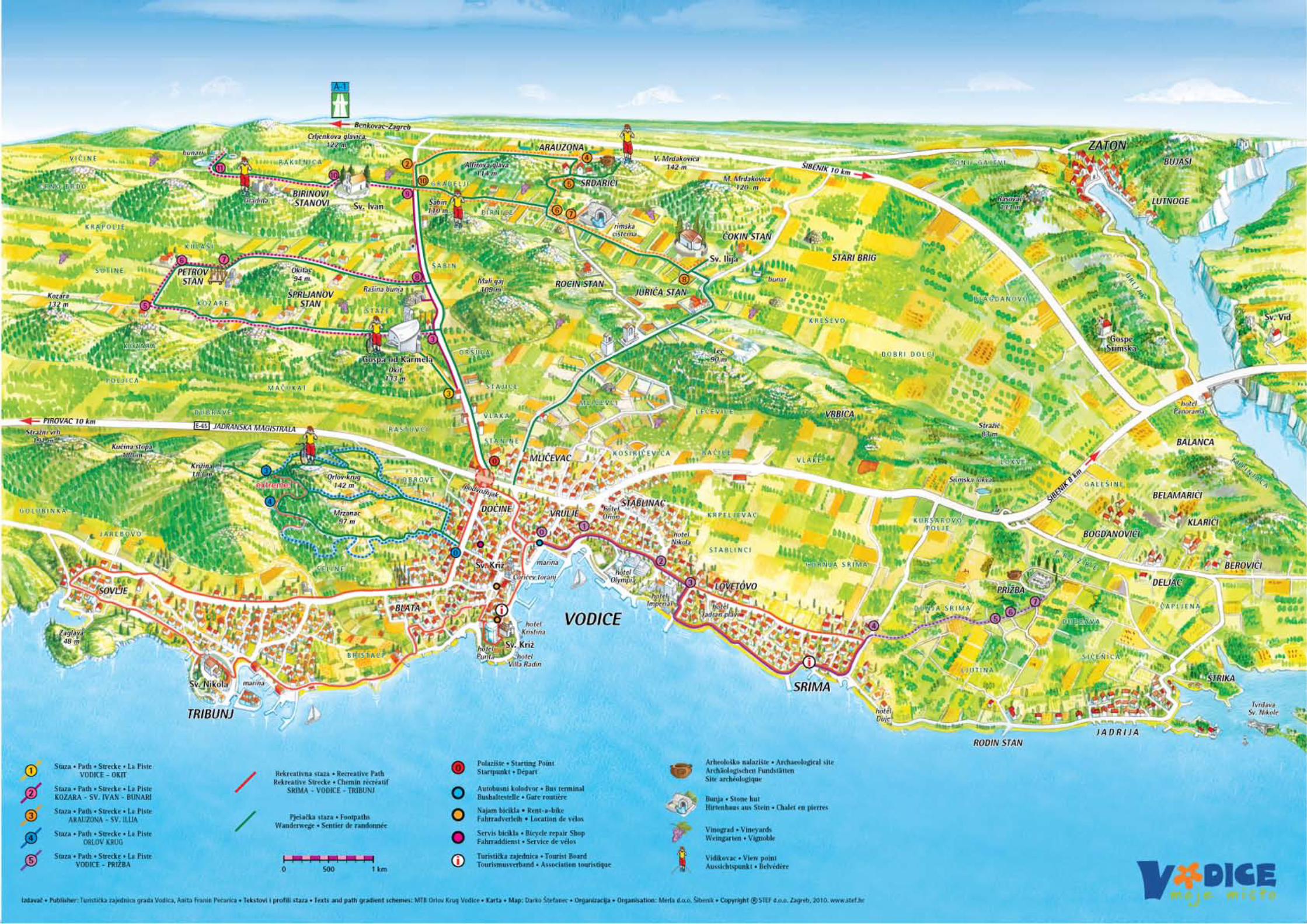
Za posudbu bicikla i opreme, te detaljnije informacije, obratite se info centru turističke zajednice grada Vodica ili MTB Orlov krug.
Rekreativna staza Srima-Vodice-Tribunj nije posebno označena biciklističkim znakovima, a vozi se lokalnom cestom.
Informacije • Information • Informationen • L’Information
TEL: ++ 385 22 443 888 • ++ 385 98 337 458 www.vodice.hr
The recreative path Srima-Vodice-Tribunj is not specifically marked with bicycle signs and is ridden on the local street.
Die rekreative Strecke Srima-Vodice-Tribunj ist nicht besonders gekennzeichnet mit Fahrradkennzeichen und man fährt über die
lokale Straße.
Le chemin récréatif Srima-Vodice-Tribunj n’est pas marqué particulièrement par des signaux pour des cyclistes,
et on conduit sur la route locale.
To hire bicycles and equipment or for more detailed information, please contact the Vodice Tourist Board Information Centre or MTB “Orlov krug”.
Wenn Sie Fragen zum Fahrradverleih und Ausrüstung haben und weitere Informationen benötigen, wenden Sie sich an das INFO Zentrum der
Tourismusverband Vodice oder an MTB “Orlov krug”.
Pour louer un vélo et l’quipement ainsi que pour des renseignements détaillés adressez-vous au centre d’information de l’Association
touristique de la ville Vodice ou MTB “Orlov krug”.
Početak staze je kod podvožnjaka. Duljina staze je 5,8 km.Staza je kratka, cijelim putem asfaltirana, ali jako zahtjevna zbog strmog uspona na svetište Okit i vidikovac. Može se voziti svim biciklima. Od početne T-0 vozimo se do T-3, gdje skrećemo lijevo (biciklistička oznaka) do vrha Okita.
VODICE - OKIT PATHThe beginning of this path is by the underpass. The length of the path is 5,8 km long. The path is short, paved and very challenging because of its steep mounting by the fane of Okit and the viewpoint. All bikes can ride this path. From the beginning of T-0 we ride until T-3 where we turn left (bicycle sign) to the top of Okit.
STRECKE VODICE - OKITStartpunkt bei der Unterführung. Länge des Fahrradwegs ist 5,8 km. Die Strecke ist kurz, asphaltiert, aber sehr anspruchsvoll wegen der steilen Steigung zum und dem Aussichtspunkt. Mit allen Fahrrädern befahrbar. Von dem beginnenden Punkt T-0 fährt man bis T-3, wo man dann links abbiegt (Fahrradkennzeichen) bis zur Spitze des Berges Okit.
LA PISTE VODICE - OKITLa piste commence au passage sous le pont. Sa longueur est de 5,8 km. C’est une piste courte, asphaltee sur tout son cours, mais très exigeante à cause de sa brusque montée vers le lieu de pèlerinage Okit et sa vue époustouflante. Tous types de bicyclettes peuvent l’emprunter. Depuis le point de départ T-0 on roule jusqu’au point T-3 où l’on tourne à gauche (signalisation de bicyclette) jusqu’au som-met d’Okit.
Početak staze je kod podvožnjaka. Duljina staze je 17,3 km.Staza je manje zahtjevna, bez većih uspona i spustova. Od početne pozicije T-0 vozimo se asfaltom do T-3, gdje skrećemo lijevo (biciklistička oznaka) i nastavljamo makadamom (po kojem mogu voziti svi bicikli) do T-5 ( biciklistička oznaka), gdje skrećemo desno. Slijedi lagani spust do T-6 i dalje do T-7, gdje skrećemo lijevo. Na poziciji T-8 izlazimo na asfalt i skrećemo lijevo, vozimo do T-9, gdje skrećemo lijevo na makadam (biciklistička oznaka). Na poziciji T-10, u podnožju Gradine, nalazi se crkva sv. Ivana. Od crkve vozimo dalje do točke T-11, zatim skrećemo desno (biciklistička oznaka) prema buna-rima. Na početnu poziciju vraćamo se istim putem bez skretanja na T-8.
KOZARA - ST. IVAN - WELLS PATHThe beginning of this path is by the underpass. The length of the path is 17,3 km long. The path is less challenging without any great slopes and mountings. From the start point of T-0 we ride on pavement until T-3 where we turn left (bicycle sign) and continue on a dirt road (on wich all bikes can ride) to T-5 (bicycle sign), where we turn right. Following is a light slope to T-6 and further on to T-7 where we turn left. At position T-8 we exit onto the pavement and turn left and we ride to T-9 where we make a left unto the dirt road (bicycle sign). At position T-10, at the foot of Gradina ruins is the church of St. Ivan. From church we ride further on to point T-11 following which we turn right (bicycle sign) towards the wells. We return to the starting point without turning at T-8.
STRECKE KOZARA - HL. IVAN - BRUNNENStartpunkt bei der Unterführung. Die Länge des Weges ist 17,3 km. Die Strecke ist weniger anspruchsvoll, ohne größere Steigungen und Abgänge. Von der Anfangsposition T-0 fährt man über den asphalti-erten Weg zu T-3, wo man links abbiegt (Fahrradkennzeichen) auf einen Feldweg (das von allen Fahrrädern befahren werden kann), bis zu T-5 (Fahrradkennzeichen), wo man dann links abbiegt. Es folgt ein leichter Abgang bis T-6 und weiter bis T-7, wo wir dann links abbie-gen. Auf der Position T-8 kommen wir zum asphaltierten Teil der St-recke und biegen links ab, wir fahren bis T-9, wo wir dann links wieder auf einen Feldweg abbiegen (Fahrradkennzeichen). Auf der Position T-10, am Fuße von Gradina ruinestätte, befindet sich die Kirche des Hl. Ivan. Von der Kirche fahren wir weiter bis zum Punkt T-11, dann biegen wir rechts ab (fahrradkennzeichen), richtung zu den Brunnen. Zur Startposition kommen wir über dieselbe Strecke ohne auf T-8 ab-zubiegen.
LA PISTE KOZARA - ST IVAN - LES PUITSLa piste commence au passage sous le pont. Sa longueur est de 17,3 km. La voie est moins exigeante, sans montées ni descentes trop importantes. On roule sur de l’asphalte à partir du point de départ T-0 jusqu’au point T-3 où l’on tourne à gauche (signalisation de bi-cyclette) et on continue sur une piste de macadam (utilisable par tous les types de bicyclettes) jusqu’au point T-5 (signalisation de bicyclette) où l’on tourne à droite. Petite descente jusqu’au point T-6 puis on continue jusqu’au point T-7 où l’on tourne à gauche. Au niveau T-8 on sort sur de l’asphalte et l’on tourne à gauche, puis on roule jusqu’au T-9 où l’on tourne à gauche sur une piste macadamisée (signalisation de bicyclette). Au niveau T-10 se trouve l’église St Ivan, au pied de la montagne Gradina. Depuis l’église St Ivan on continue jusqu’au point T-11, puis on tourne à droite (signalisation de bicy-clette) vers les puits. Pour retourner au point de départ on reprend la même piste sans tourner au point T-8.
Početak staze je kod podvožnjaka. Duljina staze je 19,8 km.Krećemo od T-0 asfaltom do T-2, gdje skrećemo desno (biciklistička oznaka) na makadam po kojemu mogu voziti svi bicikli. Na pozici-ji T-4 skrećemo desno (biciklistička oznaka), gdje počinje kratki, strmi uspon. Od T-5 (biciklistička oznaka) spuštamo se desno do T-6, gdje skrećemo lijevo i vozimo do T-8, uz skretanje lijevo do Sv. Ilije. Od pozicije T-8 vraćamo se do T-10, gdje izlazimo na asfalt i skrećemo lijevo prema početnoj točki. Na poziciji T-7 možemo skre-nuti lijevo i pogledati rimsku cisternu (prirodnu kaptažu vode) a na T-5 također lijevo, pješice, do arheološkog nalazišta Arauzona.
ARAUZONA - ST. ILIJA PATHThe beginning of this path is by the underpass. The length of the path is 19,8 km long. We depart from the T-0 to T-2 where we turn right (bicycle sign) onto the dirt road on which all bikes can ride. At position T-4 we turn right (bicycle sign) where a short, steep gradient begins. From T-5 (bicycle sign) we make our way down towards the right to T-6 where we make a left to T-8, with a turn left toward St. Ilija. At position T-8 we return back to T-10 where we exit onto the pavement and turn left towards the starting point. At position T-7 we can turn left and view the roman cistern and at T-5 also left, by foot towards the archeological site of Arauzona.
STRECKE ARAUZONA - HL. ILIJAStartpunkt bei der Unterführung. Länge der Strecke 19,8 km.Wir fahren von T-0 über den asphlatierten Weg bis T-2, wo wir dann rechts (Fahrradkennzeichen) auf einen Feldweg, auf den alle Fahrräder fahren können, abbiegen. Auf der Position T-4 biegen wir rechts ab (Fahrradkennzeichen), wo eine kurze, steile Stei-gung beginnt. Von T-5 (Fahrradkennzeichen) fahren wir herunter bis T-6, wo wir dann links abbiegen und bis T-8 weiterfahren, wo-bei wir links bis zur Kirche des Hl. Ilija abbigen. Von der Position T-8 kehren wir bis T-10 zurück, auf den asphaltierten Weg und biegen dann links bis zur Startposition. Auf der Position T-7 können wir links abbiegen und den römischen natürlichen Wasserbehälter besichtigen; auf dem Punkt T-5 links, kann man zu Fuß zu dem ar-cheologischen Arauzona Fundort kommen.
LA PISTE ARAUZONA - ST ILIJAElle commence au passage sous le pont. Sa longueur est de 19,8 km. On part du point T-0 en asphalte jusqu’au point T-2 où l’on tourne à droite (signalisation de bicyclette) sur du macadam où ont accès tous les types de bicyclettes. A l’endroit T-4 on tourne à droite (signalisation de bicyclette) d’où commence une courte pente abrupte. Depuis le point T-5 (signalisation de bicyclette) on entame la descente jusqu’au point T-6 où l’on tourne à gauche et on continue jusqu’au point T-8 où l’on tourne à gauche jusqu’au la chapelle St Ilija. Depuis l’endroit T-8 on retourne au point T-10 où on monte sur de l’asphalte et on tourne à gauche vers le point ini-tial. A l’endroit T-7 on a le choix de tourner à gauche pour admirer la citerne romaine ou au point T-5 de tourner également à gauche pour aller à pied jusqu’au site archéologique d’Arauzona.
Početak staze je raskrižje nasuprot škole (biciklistička oznaka). Dulji-na staze je 6,36 km. Staza Orlov krug jako je zahtjevna i namijenjena isključivo MTB biciklima. Na ovoj stazi svake godine u svibnju vozi se hrvatski i svjetski MTB kup. Staza je označena biciklističkim oznaka-ma. Do T-3 posebno su zahtjevni usponi a od T-3 do T-4 opasni su spustovi. Na poziciji T-3 nalazi se vidikovac (najviša točka) s kojeg se, osim Kornata i ostalih otoka šibenskog arhipelaga, vidi većina sredn-jodalmatinskih otoka.
ORLOV KRUG PATHThe beginning of this path is at the crossing opposite of the school (bicycle sign). The length of the path is 6,36 km long. The Orlov krug path is a very challenging path only for MTB bikes. Every year in May, this path hosts the Croatian and World MTB Cup. The path is marked with bicycle signs. Up to T-3, there are specifically challeng-ing mountings and from T-3 to T-4 there are dangerous slopes. At the position T-3 there is a viewpoint on which you can see the Kornati islands and other islands of the ©ibenik archipelago as well as a num-ber of middle Dalmatian islands.
STRECKE ORLOV KRUGStartpunkt ist die Kreuzung gegenüber der Schule (Fahrradkennze-ichen). Länge der Strecke 6,36 km. Die Strecke Orlov Krug ist sehr anspruchsvoll und ausschließlich für MTB-Fahrräder gedacht. Jedes Jahr im Mai findet auf dieser Strecke der Kroatien - und der Welt-Cup statt. Die Strecke ist mit Fahrradkennzeichen gekennzeichnet. Bis T-3 sind besonders die ansprucksvollen Abgänge T-3 und T-4 Gefährlich. Auf der Position T-3 befindet sich der Aussichtspunkt von wo man die Kornati Inseln und andere mitteldalmatinischen Inseln können von hier aus gesehen werden.
LA PISTE ORLOV KRUG Elle commence au croisement en face de l’école (signalisation de bi-cyclette). Sa longueur est de 6,36 km. C’est une piste très exigeante et réservée exclusivement aux bicyclettes MTB. C’est sur cette piste just-ement qu’a lieu chaque année en mai la coupe croate et mondiale de MTB. La piste est signalisée par une bicyclette. Les montées sont très exigeantes jusqu’au point T-3, et du point T-3 au point T-4 la de-scente en est dangereuse. Au point T-3 se trouve le point culminant d’où l’on voit la plupart des îles de l’Adriatique centrale à côté des îles de Kornati et d’autres îles de l’archipel de ©ibenik.
Do srimske biciklističke staze možete lako stići iz Srime ili Vodica.Početak staze je kod autobusnog kolodvora. Duljina staze je 6 km.Uputite li se iz Vodica, od autobusnog kolodvora šetnicom uz more, na T-1 skrećete udesno na uzbrdicu i vozite asfaltiranom cestom sve do hotela Olympia i Imperijal (T-2). Na T-3 ponovo skrećete udesno prema obali mora i vozite uz plažu po izrazito ravnoj cesti sve do središta Srime. Ovdje krećete lijevo do oznake za biciklističku stazu (T-4) i skrećete desno. Stigli ste u labirint suhozida, (T-5,6,7 sa biciklističkim oznakama) a staza završava kod kasnoantičke dvojne bazilike Prižba.
VODICE - PRIŽBA PATHFrom the villages Srima and Vodice it is easy to reach the cycling path Srima. The beginning of this path is at the bus terminal. The length of the path is 6 km long. At the bus terminal in Vod-ice take the road by the sea. At T-1 turn right and drive along the asphalted road to the hotels Olympia and Imperial (T-2). At T-3 turn right to the seashore and go along the beach on a straight way right to the centre of Srima. At this point turn to the left and go to the sign for the cycling path (T-4) and then turn right. You have reached the dry stone walls labyrinths (there are signs for the cycling paths at T-5,6 and 7) and the trail ends next to the Late Antique double basilica of Prižba.
STRECKE VODICE - PRIŽBAAus Srima und Vodice kommt man schnell zum Fahrradweg Srima. Startpunkt bei der Busbahnhof. Länge der Strecke 6 km. Vom Bus-bahnhof in Vodice führt Sie der Weg entlang der Uferpromenade; auf dem T-1 biegen Sie rechts bergab und fahren die asphaltierte Straße entlang bis zu den Hotels Olympia und Imperial (T-2). Auf dem T-3 biegen Sie wieder rechts zum Ufer und fahren auf dem geraden Weg bis zum Zentrum von Srima. Hier biegen Sie Richtung Norden bis zum Schild für Fahrradweg (T-4). Sie sind Ins Labyrinth des Trocken-mauerwerks gekommen (T-5,6 und 7 mit Fahradwegschildern) und der Pfad endet bei der Doppelbasilika Prižba aus der Späten Antike.
LA PISTE VODICE - PRIŽBAVous avez facilement accès à la piste cyclable de Srima à partir de Srima ou de Vodice. La piste commence à la gare routière. Sa longueur est de 6 km. En partant de Vodice, de la gare routière, vous vous promenez à bicyclette le long de la mer ; au T-1 vous tournez à droite, prenez la montée et roulez sur la route goudronnée jusqu’à l’hôtel Olympia, puis Imperial (T-2). Au T-3 vous tournez à nouveau à droite vers la mer et roulez le long de la plage sur une route tout à fait droite jusqu’au centre de Srima. Là vous allez à gauche jusqu’à la signalisation de la piste cyclable (T-4) puis vous tournez à droite. Vous êtes arrivés dans le labyrinthe du mur de pierres sèches (T-5,6,7 avec les signalisation pour bicyclettes), et la piste se termine auprès de la basilique double de l’Antiquité tardive de Prižba.
OKIT
SV. IVAN
RIMSKA CISTERNA
PRIŽBASV. ILIJAOKIT, Gospa od Karmela