Embed Size (px)
Citation preview

Beyond Sentinel-2 with UrtheDaily Constellation
for Land and Agriculture Monitoring
Jamie Ritchie, Commercial Director, Deimos Imaging, an UrtheCast CompanyIACS, Ghent, May 31, 2017

IACS, Ghent, May 31, 2017
Canada HQ & Engineering (“UrtheCast”) | Spain Satellite Operations & EO Services (“Deimos Imaging”) | ~
250 people
Who is UrtheCast?
2
Plans Announced for Future Satellite Constellations
Serving the rapidly growing and
evolving geospatial and
geoanalytics markets
8 Satellite UrtheDailyTM 16 Satellite OptiSARTM
Customer funded and financed systems with
unprecedented imaging capabilities
Operational Satellites / ISS Sensors

IACS, Ghent, May 31, 2017
A space-based Geospatial Big Data collection, processing, and information management
system — completely vertically-integrated.
A Vertically-Integrated EO System
Midstream
UrthePlatformSatellites
Upstream Downstream
UrthePipeline
Ground Segment
3

Today4

IACS, Ghent, May 31, 2017
We provide a unique portfolio of EO products, and it’s evolving.
UrtheCast’s EO Sensor System, Today
UrthePlatformDeimos-1
Medium-res
broad area
coverage
Theia
Medium-res
still imagery
Deimos-2
High-res
still imagery
Iris
High-res
video
5
API-based cloud
platform

IACS, Ghent, May 31, 2017
Deimos-1Medium-Resolution Imagery
Launched
Pixel size
Bands
Image width
Revisit time
Image time
2009
20 m
3 (Red, Green, NIR)
650 km
3 days average, worldwide
Mid-morning (10:30 AM)
Key Features
• Designed for agriculture, forestry and large-scale change detection
• Capable of acquiring up to 8 million sqkm per day, high quality data
• Precisely cross-calibrated with Landsat-7/8 and Sentinel-2
• Used by ESA for large-scale monitoring since 2010
• Used by USDA for crop monitoring in the US since 2011
6

IACS, Ghent, May 31, 2017
Deimos-1
7
Landsat-8: 16 days Deimos-1: 2 days

IACS, Ghent, May 31, 2017
Deimos-1The world leading imagery source for large scale agriculture
• Unmatched capacity of fast cloud-free coverage of very large areas, thanks to 650-km swath
• Operated by Deimos Imaging in constellation with Airbus’ UK-DMC2
• New 2017 coverage & all archive since 2011 is available through AWS
Example: One cloud-free coverage of CONUS every 15 days during crop season, for USDA since
2011
8

IACS, Ghent, May 31, 2017
Deimos-1The world leading imagery source for large scale agriculture
Example: Crop identification using Deimos-1 data (USDA CropScape)
9
IACS, Ghent, May 31, 2017
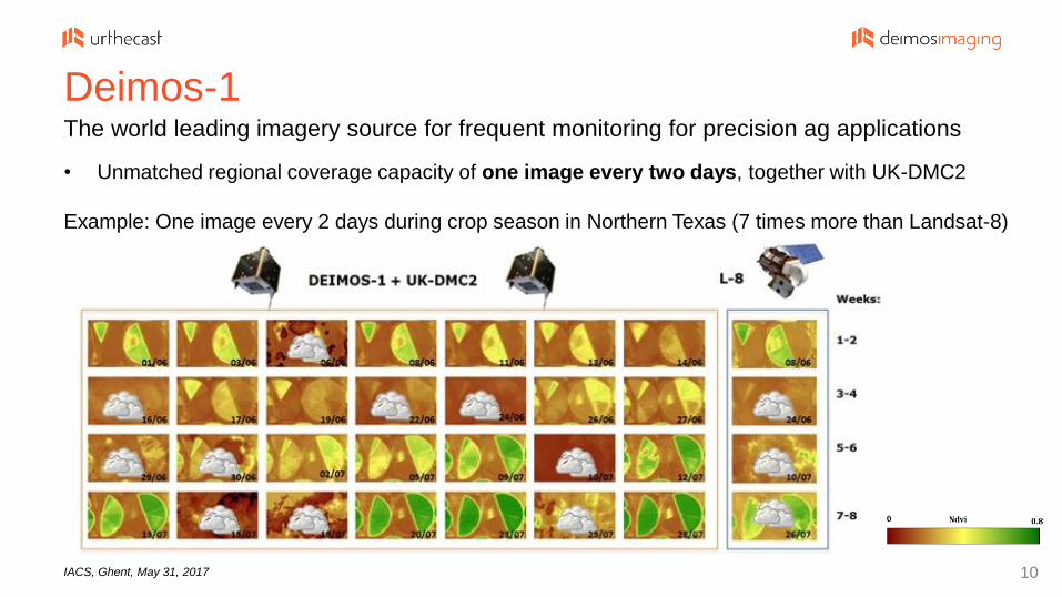
Deimos-1The world leading imagery source for frequent monitoring for precision ag applications
• Unmatched regional coverage capacity of one image every two days, together with UK-DMC2
Example: One image every 2 days during crop season in Northern Texas (7 times more than Landsat-8)
10

IACS, Ghent, May 31, 2017
Deimos-2High-Resolution Imagery
Launched
Pixel size
Bands
Image width
Revisit time
Image time
2014
75 cm
5 (Red, Green, Blue, NIR, PAN)
12 km
2 days average, worldwide
Mid-morning (10:30 AM)
Key Features
• High-quality, high-resolution
• Designed for defence & intelligence, cartography, frequent monitoring
• Capable of stereo acquisitions for large-scale 3D modelling
• Designed for fast tasking: up to few hours before acquisition
• Ultra-rapid delivery time: within 1 hour from acquisition, 24/7/365
11

PanGeo Alliance

IACS, Ghent, May 31, 2017
• With eight member entities worldwide, it provides access to an unprecedented
fleet of Earth Observation sensors, which will greatly expand in the coming years.
The PanGeo AllianceThe First Worldwide Alliance of Earth Observation Satellite Operators
13

IACS, Ghent, May 31, 2017
• 12 operational imagery sensors, plus 3 AIS satellites
• 56 satellites to be launched in the coming years
• Unprecedented portfolio: imagery (20m to 75cm/pixel), 4k full-color videos, AIS
• PanGeo Alliance members can provide Alliance data to customers worldwide
The PanGeo AllianceA unique (and growing) fleet of 15 operational Earth Observation sensors
14

IACS, Ghent, May 31, 2017
The Bridge to UrtheDailyTM: Powerful Solutions Today Between current UrtheCast, PanGeo Alliance and UrthePlatform EO datasets, we can offer a highly
diverse and competitive dataset for geoanalytics – today.
15
10 sensors in orbit, 18 more to be launched before 2020

Tomorrow16

IACS, Ghent, May 31, 2017
We are developing our Next GenerationCustomer-driven progression of sensors and infrastructure, based on three synergetic pillars:
Theia IrisDeimos-1 Deimos-2
Platforms
Cloud Platform
OptiSARTM
Constellation
UrtheDailyTM
Constellation
In-House Archive
17

IACS, Ghent, May 31, 2017
UrtheDailyTM: a daily world for GeoAnalytics

IACS, Ghent, May 31, 2017
The UrtheDailyTM Constellation All the World, Everyday, at 10:30 AM, at 5m/pixel, through a user-friendly cloud platform
8 satellites to produce consistent, reliable, daily delivery of 140 M km2 of analytics-ready imagery
Product: Multispectral, 5m/pixel, scientific-quality imagery, with full global daily coverage
Service: Through the cloud, and via APIs, all based on the UrthePlatform
UrtheDailyTM will enable daily, global change detection and analysis at unprecedented scale.
UrtheDailyTM operations to start in 2019
BEST COVERAGE
19
• Developed following years of study, as natural
evolution of the Deimos-1 and Theia experiences
• Incorporates market lessons learned via current
assets and customers
• An unprecedented and disruptive
product/service, tailored for GeoAnalytics

IACS, Ghent, May 31, 2017
Swath width vs. No. of satellites
Swath width and GSD vs. Altitude
Pixels per camera vs. No. of cameras
Payloads vs. Power system design
Bus size and weight vs. Launch system
Spectral bands vs. Customers’ needs
Spectral bands vs. Other missions
GSN Antennas vs. Latency
Daily throughput vs. GS architecture
Automation vs. Operational costs
UrtheDailyTM – Designed and Optimized for Daily CoverageOptimizes all the main trade-offs:
20

IACS, Ghent, May 31, 2017
UrtheDailyTM SpacecraftBuilt in partnership with Surrey Satellite Technology Ltd.
Satellites: 8, equally spaced
Orbit: 600 km SSO, 10:30 LTAN
Spacecraft: Based on SSTL-250 bus
Mass: 340 kg
Size: 1.1 m x 1.1 m x 0.8 m
Design Life: 10 years
Launch: Falcon 9 (all 8 s/c at once) Always imaging over land
Always nadir pointing
Always a 360 km swath21

IACS, Ghent, May 31, 2017
An Eye on Data Quality and UsabilityDesigned for high data quality & ‘out-of-the-box’ analytics-ready usability that customers require
• UrtheCast has worked with geoanalytics companies around the world to define and
refine the data specifications required to ensure success for analytics partners
• The UrtheDailyTM system aims to enable ultra-high sensor spectral calibration and
geolocation accuracy that will exceed the data quality of the RapidEye system
• Targeted specifically at geoanalytics applications to optimize the ability to reliably
extract information from the imagery and to detect subtle changes:
• Scientific grade radiometric calibration
• High SNR and bit depth
• High geo-location accuracy
• Narrow spectral bands selected to match Sentinel-2 bands, and minimize effects
due to atmospheric variations
22

IACS, Ghent, May 31, 2017
The UrtheDailyTM Data Stream: 20+ Tb/dayGlobal, daily, 5m dataset with Sentinel-2 quality, through a user-friendly cloud platform
Example UrtheDaily image at 5m/pixel
23
Daily global snapshot
Data pipelined on the cloud within few hours
Scientific grade data quality
Always consistent through cross-calibration
Conceived for M2M analyses
Spectral bands as Sentinel-2/Landsat-8
Fully consistent with free datasets
Image format is analytics-ready
Long-duration of service (10 Yrs)
SLA with our customers

IACS, Ghent, May 31, 2017
Why UrtheDaily? Developed with & for Our Customers
24
Land-o-Lakes announced as Anchor Customer of UrtheDaily in February 2017

OptiSARTM: the first fully-integrated optical+SAR25
OptiSARTM: a closer look, anywhere, at any time

IACS, Ghent, May 31, 2017
The OptiSARTM ConstellationThe World’s first fully-integrated constellation of Optical and SAR satellites
16 Satellites in two orbit planes
Satellites are arranged in 8 pairs:
SAR (X+L bands) + Optical (50 cm)
This arrangement allows for:
• Very high assured (day/night, cloudy or
not) revisit worldwide
• Imaging of the same location with SAR
and Optical, at the same time
• Optimized multispectral imaging
through cloud avoidance
BEST REVISIT
26
OptiSARTM operations are scheduled to start in 2021

IACS, Ghent, May 31, 2017
SummaryDesigned for high data quality & ‘out-of-the-box’ analytics-ready usability that customers require
• High quality daily data for product generation ready for 2019 growing season
• The UrtheDailyTM data is complimentary with Sentinels
• Optimize the ability to reliably extract information from the imagery and to detect subtle
changes:
• Scientific grade radiometric calibration
• High SNR and bit depth
• High geo-location accuracy
• Narrow spectral bands selected to match Sentinel-2 bands, and minimize effects
due to atmospheric variations
• Only receive the data needed for small parcels, 5x5m minimum areas
27