Embed Size (px)
Citation preview

Baseline Document for Maintenance
Dredging in Plymouth Sound and Estuaries European Marine Site
August 2010 Revised March 2011
working in partnership with

Debut Services (SW) Ltd Defence Estates
Baseline Document for Maintenance Dredging in Plymouth Sound and Estuaries European Marine Site
Black & Veatch Ltd 14 March 2011
i
Document issue details:
B&V project no. 120910 Client’s reference no. Version no. Issue date Issue status Distribution
1 18/12/2009 Draft Debut/ Defence Estates
2 23/04/2010 Final Draft for Consultation Natural England
3 18/06/2010 Final Draft for Consultation Internal Review
4 02/08/2010 Final Debut, Natural England, Environment Agency, MMO
5 14/03/2011 Revised Natural England
Notice:
This report was prepared by Black & Veatch Limited (BVL) solely for use by Debut Services (South West) Ltd and Defence Estates. This report is not addressed to and may not be relied upon by any person or entity other than Debut Services and Defence Estates for any purpose without the prior written permission of BVL. BVL, its directors, employees and affiliated companies accept no responsibility or liability for reliance upon or use of this report (whether or not permitted) other than by Debut Services and Defence Estates for the purposes for which it was originally commissioned and prepared.
In producing this report, BVL has relied upon information provided by others. The completeness or accuracy of this information is not guaranteed by BVL.

Debut Services (SW) Ltd Defence Estates
Baseline Document for Maintenance Dredging in Plymouth Sound and Estuaries European Marine Site
Black & Veatch Ltd 14 March 2011
EXECUTIVE SUMMARY
Where maintenance dredging is carried out in a Natura 2000 site, the UK Government has requested that a “baseline document” is prepared to assess the activities in accordance with Article 6(3) of the EC Habitats Directive (92/43/EEC). The baseline document should draw on readily available information to describe current and historic patterns of dredging in relation to the conservation objectives of adjacent European marine sites. This report represents the ‘Baseline Document’ for the MoD at Devonport Naval Base, and contains information relevant to the integrity of the Plymouth Sound and Estuaries European Marine Site (EMS), comprising the Plymouth Sound and Estuaries Special Area of Conservation (SAC) and the Tamar Estuaries Complex Special Protection Area (SPA) and eight associated Sites of Special Scientific Interest (SSSIs). The Plymouth Sound and Estuaries EMS currently supports maintenance dredging activities in Plymouth Sound, Hamoaze, Cattewater and locally at MoD facilities in the Tamar River. The maintenance dredging is predominantly undertaken for the naval Dockyard but smaller quantities are also removed from Cattewater Harbour and occasionally, locally from within some marinas. The area has been extensively studied by others in recent years but comparison of historical maps and charts, which show little natural change to the features of the Complex, has been contradicted by the previously calculated sediment budget, which appears to show an unsustainable loss of sediment form the system due to maintenance dredging. Actual maintenance dredging quantities over the past 6 years have averaged 72,500 tonnes per annum with a maximum in any one year of 147,904 tonnes (2004 “catch-up” at start of new term contract) which compares to an estimated fluvial input of 75 to 150,000m3 of fluvial sediment per annum. The maintenance dredging is less than the estimated fluvial input, and furthermore the maintenance material is largely from fluvial sources and has not settled out in the estuary above the Dockyard. It may therefore be regarded as being lost to the estuary. If maintenance dredging were to cease the dredge boxes would fill in initially and thereafter there would be an increase in sediment being carried naturally out to sea. Plymouth Sound and Estuaries EMS, comprises the Plymouth Sound and Estuaries SAC (including the Sound itself together with Wembury Bay and the River Yealm) and the Tamar Estuaries Complex SPA which lies north of the Sound and includes the area of St John's Lake, Hamoaze, Lynher River and the River Tamar. The Plymouth Sound and Estuaries SAC is regarded to be of international conservation importance due to diverse salinity conditions, sedimentary and reef habitats. The wide variety of habitats gives rise to communities representative of ria systems with unusual features, such as populations of Mediterranean and Atlantic species rarely found in British waters. In respect to the SPA designation, the Tamar Estuaries Complex qualifies under the EU Birds Directive because the area supports internationally important numbers of migratory Egretta garzetta (little egret) and Recurvirostra avosetta (avocets). The extensive intertidal mudflats of the estuary system have diverse infaunal communities rich in bivalves and other invertebrates which provide feeding grounds for waterbirds in numbers of international importance.

Debut Services (SW) Ltd Defence Estates
Baseline Document for Maintenance Dredging in Plymouth Sound and Estuaries European Marine Site
Black & Veatch Ltd 14 March 2011
Previous studies (PMA, 2004) have indicated that maintenance dredging and capital deepening of the main channel appear to have had no long term impact upon the intertidal extent of the estuary. It is considered that changes to the cross-sectional area of the estuary due to historic modifications of the Dockyard and dredging between 1895 and 2001 appear to have had an insignificant impact upon the overall estuarine tidal dynamics. Where evidence exists, there do not appear to have been any changes in the abundance of biota. This is with respect to the post 1985 peak in dredging activity at Weston Mill Lake. A recent study by Widdows et al., (2007) assessed the potential impact of dredging activity on the Tamar Estuary with respect to ecological changes. The study concluded that there were no significant correlations between overwintering numbers of wildfowl and wader birds and dredging activity and that there was also no evidence of ecological changes related to the dredging activity in the Tamar. The Marine Conservation Society has recommended that dredging in the shipping channel should be restricted to areas away from the south of the Hoe due to the presence of a nationally scarce species, the fan shell Atrina fragilis (MCS, 2004). The influence of maintenance dredging activity on the marine environment, and associated habitats and species (including the Allis shad) is likely to be negligible because of the lack of any impact of dredging on the wider coastal processes, outside of the estuary. This Baseline Document concludes that the present maintenance dredging practices are sustainable and not having an adverse effect on the features of the SAC.

Debut Services (SW) Ltd Defence Estates
Baseline Document for Maintenance Dredging in Plymouth Sound and Estuaries European Marine Site
Black & Veatch Ltd 14 March 2011
CONTENTS
EXECUTIVE SUMMARY II
1 INTRODUCTION 1 1.1 Background............................................................................................................1 1.2 Context and Scope of the Baseline Document .....................................................1 1.3 Objectives ..............................................................................................................3 1.4 Methodology ..........................................................................................................3 1.5 Report Structure.....................................................................................................4
2 EXISTING DREDGING REGIME 5 2.1 Overview of Activity................................................................................................5 2.2 Summary of Naval Base Dredging Operations .....................................................8 2.3 Capital Dredging ..................................................................................................14 2.4 Dredging Since SAC Designation........................................................................15 2.5 Other Maintenance Dredging Operations............................................................17 2.6 Previous bathymetric studies...............................................................................18
3 PLYMOUTH SOUND AND ESTUARIES EUROPEAN MARINE SITE 19 3.1 Overview ..............................................................................................................19 3.2 Conservation Objectives......................................................................................19 3.3 Current Conservation Status ...............................................................................21
4 SITES OF SPECIAL SCIENTIFIC INTEREST 37 4.1 Introduction ..........................................................................................................37 4.2 Tamar-Tavy Estuary Site of Special Scientific Interest .......................................39 4.3 Lynher Estuary Site of Special Scientific Interest................................................40 4.4 St. John’s Lake Site of Special Scientific Interest ...............................................41 4.5 Yealm Estuary Site of Special Scientific Interest.................................................42 4.6 Western King Site of Special Scientific Interest ..................................................43 4.7 Wembury Point Site of Special Scientific Interest ...............................................44 4.8 Kingsand to Sandway Point Site of Special Scientific Interest............................45 4.9 Rame Head & Whitsand Bay Site of Special Scientific Interest..........................46 4.10 Plymouth Sound Shores and Cliffs Site of Special Scientific Interest.................47
5 DESCRIPTION OF BASELINE CONDITIONS 49 5.1 Coastal Processes and Geomorphology.............................................................49 5.2 Estuarine Habitats and Ecology ..........................................................................56 5.3 Marine Habitats and Ecology...............................................................................59 5.4 Sediment Quality..................................................................................................59 5.5 Water Quality .......................................................................................................69 5.6 Ornithology...........................................................................................................77 5.7 Noise (In respect of disturbance to birds)............................................................79 5.8 New and Future Relevant Legislation..................................................................79
6. CONCLUSIONS AND RECOMMENDATIONS 82 The Influence of Historic Dredging Activity on the Plymouth Sound and Estuaries
European Marine Site ..........................................................................................82 Future Review...................................................................................................................83
APPENDICES Appendix I – IX Condition of SSSI Units Appendix X – Westminster Dredging Register and Locations Appendix XI – Disposal data as received from the Marine Management Organisation Appendix XII – Letter from Environment Agency regarding Maintenance Dredging and Fish Migration
Debut Services (SW) Ltd Defence Estates
Baseline Document for Maintenance Dredging in Plymouth Sound and Estuaries European Marine Site
Black & Veatch Ltd 14 March 2011
This page has been left intentionally blank

Debut Services (SW) Ltd Defence Estates
Baseline Document for Maintenance Dredging in Plymouth Sound and Estuaries European Marine Site
Black & Veatch Ltd 14 March 2011
1
1 INTRODUCTION
1.1 Background
Maintenance dredging is undertaken by many ports, marinas and other facility operators to maintain safe and navigable channels and berths. It is highly regulated and consents are usually required under the Food and Environment Protection Act 1985 (FEPA) for the disposal and beneficial use of dredged materials. Similarly, consents may also be required under the Coastal Protection Act (CPA) and any relevant Harbour Act for navigation. There may also be local legislation allowing local authorities to manage their own activities and that of others within set areas for specific purposes (e.g. municipal ports).
Where maintenance dredging has the potential to affect a Natura 2000 site, such as a Special Area of Conservation (SAC) or Special Protection Area (SPA) as designated under the EC Habitats Directive 92/43/EEC, the Government considers maintenance dredging to be a ‘plan or project’ for the purposes of the Habitats Directive. Because of this, maintenance dredging operations would need to be assessed in accordance with Article 6(3) of the Directive.
A Draft Conservation Assessment Protocol on Maintenance Dredging and the Habitats Regulations 2010 (‘Draft Protocol’) has been developed to assist port authorities in fulfilling their statutory obligations of devising arrangements which allow the effects of maintenance dredging on Natura 2000 sites to be reviewed in a way which does not impose a disproportionate burden on industry, Government or its agencies.
The Draft Protocol was produced in December 2003 and trialled at a number of ports although it has not yet been adopted. It was recommended within the draft protocol that a ‘Baseline Document’ is prepared, which would draw on existing and readily available information to describe current and historic patterns of dredging in relation to the conservation objectives of adjacent European Marine Sites. This report represents the ‘Baseline Document’ for the continuation of maintenance dredging in the Tamar Estuary associated with the Devonport Naval Base.
The Devonport Naval Base lies within the Plymouth Sound and Estuaries European Marine Site. This designation comprises the Plymouth Sound and Estuaries SAC (including the Sound itself together with Wembury Bay and the River Yealm) and the Tamar Estuaries Complex SPA which lies north of the Sound and includes the area of St John's Lake, Hamoaze, Lynher River and the River Tamar. This Baseline Document therefore contains information relevant to the integrity of the Plymouth Sound and Estuaries European Marine Site and eight associated Sites of Special Scientific Interest (SSSI), see Figure 1-1.
1.2 Context and Scope of the Baseline Document
Regular maintenance dredging works are carried out within the Tamar Estuary. Several dredging practices take place either within or in ‘close proximity’ to areas designated as conservation areas, either SAC, SPA or SSSI.

Debut Services (SW) Ltd Defence Estates
Baseline Document for Maintenance Dredging in Plymouth Sound and Estuaries European Marine Site
Black & Veatch Ltd 14 March 2011
2
Figure 1-1: Study area and nature conservation designations
Debut Services (SW) Ltd Defence Estates
Baseline Document for Maintenance Dredging in Plymouth Sound and Estuaries European Marine Site
Black & Veatch Ltd 14 March 2011
3
1.3 Objectives
The objectives of this Baseline Document are to:
• combine relevant existing information about the environmental status of the study area and, in particular, what is known about the potential extent of impacts of previous capital and maintenance dredging undertaken by the Ministry of Defence, their agents or other operators within the Plymouth Sound and Estuaries European Marine Site;
• provide the data necessary to allow any maintenance dredging proposals for the Plymouth Sound and Estuaries European Marine Site to be assessed in accordance with Article 6(3) of the Habitats Directive and in line with the Draft Conservation Assessment Protocol on Maintenance Dredging and the Habitats Regulations 2010; and
• assist competent authorities in identifying ‘likely significant effects’ in respect of future maintenance dredging applications or proposals.
It should be noted that this document will require regular updating as further information becomes available, if circumstances and requirements change, and potentially as a result of any wider consultation.
According to the Draft Protocol, baseline documents are to be based on existing and readily available information (e.g. from previous applications and/or Environmental Impact Assessment (EIA), dredge disposal returns and condition monitoring. Where possible, they are intended to identify the:
• existing need for maintenance dredging in individual areas; • existing volumes, frequencies and duration of dredging operations – where
this should be based on actual dredge returns rather than volumes applied for in consents;
• precise locations of dredging and disposal; • methods of dredging, transport and disposal, including any restrictions
imposed as licence conditions or by physical constraints (e.g. depth, tidal flow, wave or weather conditions);
• material type and chemical status (existing and historical); • history of dredging and disposal at particular locations, as well as the
variability in material type and volumes due to natural changes; • any monitoring requirements previously imposed through licences, and the
outcomes of such monitoring; • any beneficial use and sediment cell maintenance schemes, or mitigation and
compensation schemes entered into; and • any other relevant information from past studies or previous applications that
have possible direct or indirect links to the maintenance dredging.
They should also include information supplied by Natural England and others (e.g. Marine Fisheries Agency (MFA), the Centre for the Environment, Fisheries and Aquaculture Science (CEFAS), Environment Agency) on the condition characteristics of the Natura 2000 site, in particular: The interest features of the site and their conservation objectives, which could be affected by maintenance dredging.
1.4 Methodology
It should be emphasised that the report is based on a desk study of existing and readily available data only. The data gathering exercise has deliberately focused on those environmental parameters that potentially could be affected by
Debut Services (SW) Ltd Defence Estates
Baseline Document for Maintenance Dredging in Plymouth Sound and Estuaries European Marine Site
Black & Veatch Ltd 14 March 2011
4
maintenance dredging and are of relevance to the integrity of the SPA and SAC shown in Figure 1-1. These include the following:
• Coastal processes and geomorphology • Sediment quality • Water quality • Estuarine and marine habitats and ecology • Ornithology • Noise (in respect of disturbance to birds)
1.5 Report Structure
Table 1.1, below, sets outs the contents of this baseline document for maintenance dredging.
Table 1.1: Report structure.
Section Description 1. Introduction Provides the background, context and scope of the
baseline document and outlines the objectives of the document.
2. Existing Dredging Regime
Details the history and operations of dredging within the Plymouth Sound and Estuary.
3. Plymouth Sound and Estuaries European Marine Site
Presents the Plymouth Sound and Estuaries European Marine Site.
4. Sites of Special Scientific interest
Provides descriptions of the eight SSSIs.
5. Baseline Conditions Provides a description of baseline conditions within the European Marine Site.
6. Discussion and Recommendations
Presents a discussion on the Influence of historic dredging activity on the Plymouth Sound and Estuaries European Marine Site and recommendations for the future.
Debut Services (SW) Ltd Defence Estates
Baseline Document for Maintenance Dredging in Plymouth Sound and Estuaries European Marine Site
Black & Veatch Ltd 14 March 2011
5
2 EXISTING DREDGING REGIME
2.1 Overview of Activity
The Plymouth Sound and Estuaries European Marine Site supports a range of waterfront activities that give rise to the need for dredging.
The Site includes the following statutory harbour authorities:
• Dockyard Port of Devonport, including three civilian statutory harbour authorities:
o Cattewater Harbour Commissioners
o Sutton Harbour Company
o ABP Millbay Dock
• River Yealm Harbour Authority
Within the Dockyard Port area there are a number of marinas, namely
• Plymouth Yacht Haven (within Cattewater)
• Yacht Haven Quay (within Cattewater)
• Queen Anne’s Battery (off Plymouth Sound)
• Sutton Harbour Marina (locked basin off Plymouth Sound)
• Mayflower International Marina (in the lower Tamar, immediately above the Narrows)
• Millbay Marina (within Millbay Dock, off Plymouth Sound).
• Royal William Yard (in the lower Tamar, immediately above the Narrows)
Maintenance dredging is dominated by the Naval dockyard, with its dredged access channel, dredged berths and enclosed basins, but includes the commercial wharves of Cattewater and a number of marinas. Most dredging is undertaken by hopper dredgers which remove the material for disposal at sea but there is understood to be widespread unregulated use of plough (bed leveller) dredging to remove high spots at marinas. Novel techniques such as water injection dredging have also been considered at some sites.
Data on dredging operations within the study area were obtained through consultation with the Queen’s Harbour Master Plymouth and Westminster Dredging Company Ltd. (although records prior to the present contract between Defence Estates and Debut, i.e., before 2004, are sparse and incomplete) and by direct contact with the civilian harbour authorities and marina operators.
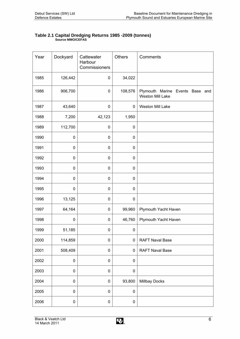
Subsequently records held by CEFAS on behalf of MMO (formerly MFA and MCEU) have been made available for the period 1985 to 2009. These records are not infallible, in that sometimes licence applications and renewals and/or variations seem to be double counted. However, the overall picture appears to be that as little as 55% of the consented quantities are actually dredged. The annual returns for capital and maintenance dredging are summarised in Table 2.1 and Table 2.2 respectively. The full data is reproduced in Appendix XI.
Debut Services (SW) Ltd Defence Estates
Baseline Document for Maintenance Dredging in Plymouth Sound and Estuaries European Marine Site
Black & Veatch Ltd 14 March 2011
6
Table 2.1 Capital Dredging Returns 1985 -2009 (tonnes) Source MMO/CEFAS
Year Dockyard Cattewater Harbour Commissioners
Others Comments
1985 126,442 0 34,022
1986 906,700 0 108,576 Plymouth Marine Events Base and Weston Mill Lake
1987 43,640 0 0 Weston Mill Lake
1988 7,200 42,123 1,950
1989 112,700 0 0
1990 0 0 0
1991 0 0 0
1992 0 0 0
1993 0 0 0
1994 0 0 0
1995 0 0 0
1996 13,125 0 0
1997 64,164 0 99,960 Plymouth Yacht Haven
1998 0 0 46,760 Plymouth Yacht Haven
1999 51,185 0 0
2000 114,859 0 0 RAFT Naval Base
2001 508,409 0 0 RAFT Naval Base
2002 0 0 0
2003 0 0 0
2004 0 0 93,800 Millbay Docks
2005 0 0 0
2006 0 0 0

Debut Services (SW) Ltd Defence Estates
Baseline Document for Maintenance Dredging in Plymouth Sound and Estuaries European Marine Site
Black & Veatch Ltd 14 March 2011
7
2007 0 0 0
2008 0 0 0
2009 0 0 0
TOTAL: 1,948.424 42,123 385,068
It can be seen from Table 2.1 over the past 25 years approximately 82% of the capital dredging disposed of at Rame Head has been attributable to the Dockyard development, and most of the remainder tom marina development. No dredging projects, other than the remediation of Deep Water Camber, have been identified in which material was disposed of onshore or in beneficial uses such as topping up of mud flats or reclamation. The material from Deep Water Camber was taken to landfill. Table 2.2 Maintenance Dredging Returns 1985 -2009 (tonnes) Source MMO/CEFAS
Year Dockyard Cattewater Harbour Commissioners
Others Comments
1985 2,873 0 16,885 HMS Raleigh, Ballast Pound Yacht Harbour Ltd and Millbay Docks
1986 5,580 Sutton Harbour
1987 27,743 0 1,578 Devonport and Millbay Docks
1988 227,580 12,825 Devonport & Sutton Harbour
1989 69,970 0 5,950 Devonport & Sutton Harbour
1990 249,900 0 0 Devonport
1991 0 0 0
1992 66,300 0 3,240 Devonport and South Down Quay
1993 92,800 0 0 Devonport
1994 604,709 0 0 Devonport and Plymouth Sound Channels
1995 459,589 19,387 2,940 Devonport and Plymouth Sound Channels
1996 0 0 0
1997 163,240 0 0 Devonport and Ernsettle
1998 0 29,120 0

Debut Services (SW) Ltd Defence Estates
Baseline Document for Maintenance Dredging in Plymouth Sound and Estuaries European Marine Site
Black & Veatch Ltd 14 March 2011
8
1999 0 12,846 0
2000 0 0 0
2001 559,787 26,875 0 Devonport
2002 0 11,984 0
2003 0 23,415 0
2004 147,904 0 0 Devonport
2005 140,321 0 0 Devonport
2006 0 0 0
2007 86,958 11,925 0 Devonport
2008 24,538 0 0 Devonport
2009 38,598 0 0 Devonport
TOTAL 2,963,277 (94.5%)
124,552(4.0%)
48,998(1.5%)
Max 604,709 29,120 16,885
Min 0 0 0
Average 118,531 4,982 1,980 125,000 tonnes pa combined
It can be seen from Table 2.2 that the Dockyard accounts for 95% of the maintenance dredging, with the marinas generally requiring very little maintenance.
The following Sections give more detail on the Dockyard operations.
2.2 Summary of Naval Base Dredging Operations
2.2.1 Overview
The Naval Base in Devonport is subject to essential, regular maintenance dredging to ensure adequate under keel clearance to all vessels using the facility. Due to the Dockyard’s location within the Tamar Estuary, it is subject to the accretion of sediment transported around the estuary by tidal and fluvial flow. This sediment accretion is the target of the maintenance dredging operations.
This maintenance dredging is currently undertaken by Westminster Dredging Company Ltd., under contract to Debut Services (South West) Ltd which holds Defence Estates’ South West Regional Prime Contract.
Maintenance dredging of the Dockyard is currently carried out under a three year FEPA licence which permits the disposal of up to approximately 117,000 tonnes/year at the designated disposal site at Rame Head. For licensing purposes disposal tonnages are calculated as wet tonnages from in situ volumes at a

Debut Services (SW) Ltd Defence Estates
Baseline Document for Maintenance Dredging in Plymouth Sound and Estuaries European Marine Site
Black & Veatch Ltd 14 March 2011
9
conversion rate (bulk density) of 1.45 tonnes per m3. Historically, over the past 25 years, the average tonnage disposed of from the Dockyard is about 118,000tonnes per annum but has dropped to about 72,500 tonnes per annum over the last 6 years (under the present contract with Debut Services).
The licence is due for renewal in January 2011.
The maintenance by ploughing and dredging is carried out in occasional campaigns (usually twice a year) which last generally one to three weeks. Typically a major campaign occurs once ever one to two years with the dredged material being disposed of at Rame Head, with the intervening campaigns being removal of high spots by plough dredging.
2.2.2 Dredging Methodology
A typical maintenance dredging campaign consists of a pre-dredge survey to ascertain the amount of sediment to be dredged (accumulated silt between minimum maintained depth (MMD) and approved dredge depth (ADD)), the dredging / ploughing operation to remove / move the identified sediment and a post-dredge survey to confirm the operation.
Under the current licence, all the dredging is performed by Trailing Suction Hopper Dredgers (TSHD). This dredging method involves a self propelled vessel trailing a suction pipe with a draghead attached to the end, along the sea bed. The draghead is pulled slowly along the bed by forward motion of the vessel. The suction pipe is connected to pumps on board the vessel that provide suction to the draghead which in turn ‘sucks up’ a mixture of water and silt. The draghead can be equipped with cutting teeth for the agitation of firmer sediment or water jets to aid softer material into suspension. The silt and water travels up the suction pipe and is deposited in a hopper located in the vessel. The vessel continues to dredge until the capacity of the hopper is reached. Under the current licence, a range of TSHDs are licensed for use during the maintenance operations. The hopper capacities of these vessels range from 6,400m3 to 970m3. Once the hopper capacity is reached, the vessel then stows the suction pipe and draghead onboard and sails to the disposal site off Rame Head. At the disposal site the material in the vessel’s hopper is discharged by ‘bottom dumping’. This discharge method entails opening doors located in the bottom of the vessel’s hopper and allowing the material to fall to the seabed under gravity.
The material dredged for the maintenance works at Devonport is silt. Due to the nature of the dredging method, a full hopper consists of approximately 25% to 35% silt with the remainder being water. Excluding time for positioning and dependant on hopper capacity, a hopper can be filled in 30 minutes providing no hard material is encountered. The bottom dumping of the dredgings can take as little as five minutes.
Ploughing is usually undertaken alongside the dredging operations. Ploughing utilises a tug vessel equipped with a plough unit (a steel box suspended on cables/chains). The plough is lowered to predetermined levels and is used to drag sediment along the estuary bed. Because the vessels are small and manoeuvrable in comparison to TSHDs, ploughing is often used to move material from areas inaccessible to the main dredging plant, such as material adjacent to quay walls.
Ploughing is also used to remove high spots and ridges left between tracks of the draghead remaining in an area after dredging by TSHD. The material is ploughed from the high spot to an area which depth is below the maintained level.
During intermittent campaigns, ploughing is employed solely to maintain the minimum depth required for a dredge box. Material is ploughed from high areas

Debut Services (SW) Ltd Defence Estates
Baseline Document for Maintenance Dredging in Plymouth Sound and Estuaries European Marine Site
Black & Veatch Ltd 14 March 2011
10
into lower areas. As ploughing does not involve the bringing of sediment to the surface, the sediment is not considered to be deposited onto the sea bed when it is ploughed from one point to another. Although presently this absence of deposition means a FEPA licence is not required for ploughing, following changes to marine legislation, a Marine Licence will be required for plough dredging from 6th April 2012.
Ploughing should not lead to a significant re-suspension of sediment but if the sediment ploughed is soft it may be sufficiently disturbed to rise in suspension.
2.2.3 Locations of Dredging
The locations covered under the current contract are listed in Table 2.3 and illustrated in Figure 2-1. A more detailed breakdown of the dredged areas and their locations is presented in Appendix X.
Table 2.3: Areas Currently Maintained Under the Dredging Contract for Devonport Naval Base
Levels(mCD) No. Area Area of Plymouth Sound and Estuaries affected MMD ADD
E1 Ernesettle Jetty (Inner) River Tamar -4.3 -4.9E2 Ernesettle Jetty (Outer) River Tamar -6.1 -6.7R1 Jupiter Point Lynher Estuary -1.8 2.8R2 Trevol Channel St. Johns Lake -1.7 -2.0NY1 Lighter Berth Hamoaze -2.5 -3.1NY2 Towed Array Facility None - near Hamoaze -4.4 -5.0NY3 No.s 14,15,16 Wharfs None - near Hamoaze -8.5 -9.1NY4 No.s 10,11,12 Wharfs None - near Hamoaze -9.2 -9.8NY5 No. 13 Wharf, Drakes
Pier None - near Hamoaze -3.7 -4.3
NY6 Drakes Slip None - near Hamoaze -2.5 -3.1NY7 No.9 Wharf Hamoaze -10.7 -11.3NY8 Approach No.s 5,6,7,8
Wharfs Hamoaze -9.1 -9.7
NY9 No. 8 Wharf Hamoaze -11.0 -11.6NY10 5 Basin Entrance Hamoaze -9.0 -9.0NY11 Nos 5,6,7 Wharfs Hamoaze -11.9 -12.5NY13 No. 4 Wharf Hamoaze -8.5 -9.1NY14 No. 4 Basin None - near Hamoaze -8.5 -9.1NY15 No.3 Wharf Hamoaze -10.0 -10.3NY16 North Yard Boat Basin None - near Hamoaze -1.3 -1.6NY17 No. 3 Wharf Hamoaze -3.3 -3.6NY18 3 Basin Entrance Hamoaze -5.5 -6.1NY19 Approach Nos 1&2
Wharfs Hamoaze -7.9 -8.5
NY20 No. 2 Wharf Hamoaze -7.0 -7.6NY21 No.1 Wharf Hamoaze -10.0 -10.3MY1 Morice Yard Wharfage Hamoaze 0.0 -0.6SY1 No. 5 Jetty Hamoaze -6.5 -7.1SY2 No. 4 Dock entrance Hamoaze -0.4 -0.4SY3 No. 4 Jetty Hamoaze -4.9 -5.5SY4 No. 3 Dock Entrance Hamoaze -5.2 -5.2SY5 No. 3 Jetty Hamoaze -7.0 -7.6SY6 N0. 2 Dock Entrance Hamoaze -4.3 -4.3SY7 No.1 Basin None - near Hamoaze -6.7 -7.3SY8 No.1 Basin Entrance Hamoaze -4.9 -5.5SY9 Nos 1&2 Jetties Hamoaze -9.8 -10.5SY10 Deep Water Camber
Entrance Hamoaze -4.3 -4.3

Debut Services (SW) Ltd Defence Estates
Baseline Document for Maintenance Dredging in Plymouth Sound and Estuaries European Marine Site
Black & Veatch Ltd 14 March 2011
11
Levels(mCD) SY11 Lub oil Jetty Approach Hamoaze -8.5 -8.8SY12 Lub oil Jetty Inner(NW) Hamoaze -5.0 -5.3SY13 Lub Oil Jetty Outer Hamoaze -10.0 -10.3SY14 Lub oil Jetty Inner(SE) Hamoaze -5.0 -5.3SY15 Slip Jetty Hamoaze -6.1 -6.7SH1 Longroom Camber Hamoaze -0.5 -0.5SD1 Cobbler Channel Plymouth Sound North -5.5 -5.8SD2 Deep Water Anchorage
to C.C Plymouth Sound North -8.6 -9.1
SD3 Nos 2&3 Anchorages Plymouth Sound North -8.1 -8.6SD4 Deep Water Anchorage Plymouth Sound North -9.7 -10.2SD5 No. 7 Anchorage Plymouth Sound North -8.1 -8.6SD6 Main Approach Channel Plymouth Sound North -11.0 -11.5SD7 C Buoy Plymouth Sound North -12.0 -12.5SD8 D Buoy Plymouth Sound North -11.6 -12.1
Note – MMD = Minimum Maintained Depth, ADD = Approvedl Dredged Depth
Debut Services (SW) Ltd Defence Estates
Baseline Document for Maintenance Dredging in Plymouth Sound and Estuaries European Marine Site
Black & Veatch Ltd 14 March 2011
12
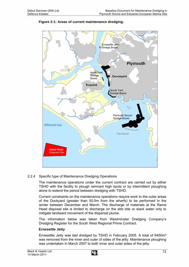
Figure 2-1: Areas of current maintenance dredging.
2.2.4 Specific type of Maintenance Dredging Operations
The maintenance operations under the current contract are carried out by either TSHD with the facility to plough remnant high spots or by intermittent ploughing alone to extend the period between dredging with TSHD.
Current constraints on the maintenance operations require work to the outer areas of the Dockyard (greater than 50.0m from the wharfs) to be performed in the winter between December and March. The discharge of materials at the Rame Head disposal site is limited to discharge on the ebb tide or slack water only to mitigate landward movement of the dispersal plume.
The information below was taken from Westminster Dredging Company’s Dredging Register for the South West Regional Prime Contract.
Ernesettle Jetty Ernesettle Jetty was last dredged by TSHD in February 2005. A total of 6450m³ was removed from the inner and outer of sides of the jetty. Maintenance ploughing was undertaken in March 2007 to both inner and outer sides of the jetty.
Plymouth Sound Dredge Boxes
North Yard Dredge Boxes
Ernesettle Jetty Dredge Boxes
South Yard Dredge Boxes
Rame Head Disposal Site

Debut Services (SW) Ltd Defence Estates
Baseline Document for Maintenance Dredging in Plymouth Sound and Estuaries European Marine Site
Black & Veatch Ltd 14 March 2011
13
Weston Mill Lake (WML) The majority of WML is maintained, bar the intertidal mud at the head. The maintained area is divided into 7 dredge boxes which are maintained to differing depths. These are NY1, NY2, NY3, NY4, NY5, NY6 and NY7. Further to these there is also the approach, NY8 which also serves the riverside wharfs of the North Yard. The last maintenance campaign for this area occurred in March 2009 with approximately 25,000m³ material removed from WML and the approach. The dredge boxes NY2, 3, 4 & 7 were also dredged in June 2008, with a total of 8000m³ of material dredged. NY3, 4&7 also were ploughed in October 2008. NY6 was ploughed in February 2007.
It should be noted that dredging at Ernesettle Trots ceased during the 2002-2003 dredge campaign. It was previously dredged to 3.9m.
Figure 2-2: Approximate Area of Ernesettle Trots
North Yard Riverside Wharfs 1 to 8 The depths of the riverside wharfs are maintained via the dredge boxes NY9, 10, 11, 13, 15, 17, 19, 20 & 21. During the March 2009 campaign approximately 7600m3 of sediment was dredged from this area. In June 2008 approximately 3050m3 of sediment was removed from these wharfs. The dredge boxes NY9, 13, 14 & 21 were maintained by ploughing in October 2008, while dredge box NY10 was ploughed in March 2006.
Debut Services (SW) Ltd Defence Estates
Baseline Document for Maintenance Dredging in Plymouth Sound and Estuaries European Marine Site
Black & Veatch Ltd 14 March 2011
14
North Yard Enclosed Basins No. 4 Basin (NY14) was dredged in June 2008 with 4850m3 of sediment removed. Ploughing of NY14 was undertaken in October 2008.
South Yard and Morice Yard The riverside jetties and dock entrances in South Yard last underwent a dredging campaign in February 2005 (dredge boxes MY1, SY1, 2, 3, 4, 5, 6, 8, 9, 12, 13 & 15). This campaign saw the removal of approximately 1900m3 of sediment. Ploughing operations have been carried out to SY1 in March 2006, SY8 in June 2007, SY11 in February 2007 and SY13 in March 2009.
Plymouth Sound The dredging register indicates that 68m3 was dredged from the Cobbler Channel in July 2005. In February 2005 dredging was undertaken at anchorages within Plymouth Sound North (see Table 2.4).
Table 2.4 Quantities dredged at anchorages in Plymouth Sound North (2005). Area Quantity dredged Deepwater Anchorage to Cobbler Channel 11,011m3 Nos 2 & 6 Anchorages 12,817m3 Deepwater Anchorage 12,841m3 No.7 Anchorage 1,472m3 Main Approach Channel 3,916m3 C Buoy 44,708m3 D Buoy 32,642m3
(Source – Westminster Dredging Ltd - Dredging Register)
2.3 Capital Dredging
Given the historic and current maritime and military importance of Plymouth Sound and Estuaries, there is a long history of capital dredging within the area. However, with respect to detecting changes in estuary morphology and previously documented activity, the available data extends from 1895 until the present day (PMA, 2004). Records of historic capital dredging are detailed in Table 2.5. Figure 2-3 provides a detailed location map for the area, and highlights the areas that have been historically dredged.
Table 2.5: Historic capital dredging.
Year Capital dredging 1901 Ernsettle Pier in Tamar River – dredge box Yonderberry Jetty – dredge box 1986-87 Weston Mill Lake – peak dredging activity 1997-98 Clovelly Bay to create Plymouth Yacht Haven in Cattewater area
(outside of SPA/SAC) (65,000 tonnes) 2000-2001 Bull Point, capital dredging for RAFT project 2003-04 Plymouth Sound channel deepening for ABP (Millbay ferry terminal) 2006 Deep Water Camber, removal of long term silt accumulation to landfill.
Executed behind silt curtain because of contamination 2007 Royal William Yard - Water injection dredging to deepen basin
(quantity not known) 2010 Millbay Dock - subject to FEPA licence, dredge of approximately
90,000m3 of inner basin (30,000m3 not disposed of at sea)
Debut Services (SW) Ltd Defence Estates
Baseline Document for Maintenance Dredging in Plymouth Sound and Estuaries European Marine Site
Black & Veatch Ltd 14 March 2011
15
2.4 Dredging Since SAC Designation
The Plymouth Sound and Estuaries SAC was proposed in 1996, and since then there have been two capital dredging projects in the SAC at Clovelly Bay and Bull Point and two projects to restore historic depths in Deep Water Camber and Millbay Dock, treated as capital dredging..
According to Marine Management Organisation records these projects produced the following tonnages of dredged material:
Clovelly Bay (Plymouth Yacht Haven) 147,000 tonnes (1997 and 1998)
Bull Point (RAFT Project) 617,000 tonnes (2001)
Plymouth Sound (ABP) 93,809 tonnes (2003)
Mill Bay Dock (Inner Basin) 130,000 tonnes (estimated) (2010)
A further 109,000 tonnes is reported to have been dredged from the Naval Base between 1998 and 2000.
The material from Deep Water Camber was removed to landfill (being contaminated) and so does not show up on MMO records.
There have been no significant changes in the maintenance dredging regime but record keeping has improved since 2004 when the maintenance of the Naval Dockyard came under the current Regional Prime Contract with Debut.

Debut Services (SW) Ltd Defence Estates
Baseline Document for Maintenance Dredging in Plymouth Sound and Estuaries European Marine Site
Black & Veatch Ltd 14 March 2011
16
Figure 2-3 Plymouth Sound and Estuaries - boundaries and areas of historic dredging.
.

Debut Services (SW) Ltd Defence Estates
Baseline Document for Maintenance Dredging in Plymouth Sound and Estuaries European Marine Site
Black & Veatch Ltd 14 March 2011 17
2.5 Other Maintenance Dredging Operations
Cattewater Harbour Commissioners The approaches to the commercial berths in Cattewater are dredged by hopper dredgers with material being disposed of at sea. A number of marinas and private jetties (e.g. Plymouth Yacht Haven, Yacht Haven Quay, Bawdon Aggregate) engage in occasional maintenance dredging by ploughing to remove high spots.
A summary of maintenance dredging at Cattewater from the main navigation channels, the pocket wharves at Cattedown Wharves, Victoria Wharves and Pomphlett Aggregate Terminal, for disposal at Rame Head. The main methods include trailer suction & bucket as well as plough dredging.
Year Spoil removed from Cattedown Harbour (tonnes) 1995 16,156 1998 21,125 1999 3,000 2001 31,835 2002 5,992 2003 16,725 2007 1,200
Millbay Dock No maintenance dredging is undertaken within Millbay Dock.
Marinas
• Plymouth Yacht Haven (Cattewater)
Much of Plymouth Yacht Haven is naturally deep enough for marina operations but the inner berths were formed by capital dredging in the 1990s. Although regular maintenance dredging has not been required it is understood that high spots are occasionally dealt with by plough dredging. Maintenance of the boat hoist dock amounting to a few hundred cubic metres may be required in the future.
• Yacht Haven Quay (Cattewater)
Maintenance of the access to the boat launching jetty may be required in the future.
• Sutton Harbour (Cattewater)
Sutton Harbour marina, which is a locked basin, has not required maintenance dredging for at least the last 10 years.
• Queen Anne’s Battery (Cattewater)
A marina wide maintenance dredge was undertaken by backhoe in 2000 with disposal at Rame Head. This is being repeated, with sectors of the harbour being targeted on a rolling programme over the next 2-3 years, starting December 2009. Disposal quantities are estimated at 5,000m3, with disposal at Rame Head. The campaign in 2000 appears in MMO records as a licence of 9,500 tonnes but the actual quantity disposed is not
Debut Services (SW) Ltd Defence Estates
Baseline Document for Maintenance Dredging in Plymouth Sound and Estuaries European Marine Site
Black & Veatch Ltd 14 March 2011 18
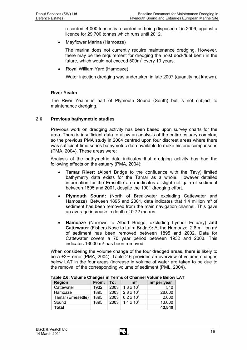
recorded. 4,000 tonnes is recorded as being disposed of in 2009, against a licence for 29,700 tonnes which runs until 2012.
• Mayflower Marina (Hamoaze)
The marina does not currently require maintenance dredging. However, there may be the requirement for dredging the hoist dock/fuel berth in the future, which would not exceed 500m3 every 10 years.
• Royal William Yard (Hamoaze)
Water injection dredging was undertaken in late 2007 (quantity not known).
River Yealm The River Yealm is part of Plymouth Sound (South) but is not subject to maintenance dredging.
2.6 Previous bathymetric studies
Previous work on dredging activity has been based upon survey charts for the area. There is insufficient data to allow an analysis of the entire estuary complex, so the previous PMA study in 2004 centred upon four discreet areas where there was sufficient time series bathymetric data available to make historic comparisons (PMA, 2004). These areas were:
Analysis of the bathymetric data indicates that dredging activity has had the following effects on the estuary (PMA, 2004):
• Tamar River: (Albert Bridge to the confluence with the Tavy) limited bathymetry data exists for the Tamar as a whole. However detailed information for the Ernsettle area indicates a slight net gain of sediment between 1895 and 2001, despite the 1901 dredging effort.
• Plymouth Sound: (North of Breakwater excluding Cattewater and Hamoaze) Between 1895 and 2001, data indicates that 1.4 million m³ of sediment has been removed from the main navigation channel. This gave an average increase in depth of 0.72 metres.
• Hamoaze (Narrows to Albert Bridge, excluding Lynher Estuary) and
Cattewater (Fishers Nose to Laira Bridge): At the Hamoaze, 2.8 million m³ of sediment has been removed between 1895 and 2002. Data for Cattewater covers a 70 year period between 1932 and 2003. This indicates 13000 m³ has been removed.
When considering the volume change of the four dredged areas, there is likely to be a ±2% error (PMA, 2004). Table 2.6 provides an overview of volume changes below LAT in the four areas (increase in volume of water are taken to be due to the removal of the corresponding volume of sediment (PML, 2004).
Table 2.6: Volume Changes in Terms of Channel Volume Below LAT
Region From: To: m³ m³ per year Cattewater 1932 2003 1.3 x 10⁴ 540Hamoaze 1895 2003 2.8 x 10⁶ 28,000Tamar (Ernesettle) 1895 2003 0.2 x 10⁶ 2,000Sound 1895 2003 1.4 x 10⁶ 13,000Total 43,540

Debut Services (SW) Ltd Defence Estates
Baseline Document for Maintenance Dredging in Plymouth Sound and Estuaries European Marine Site
Black & Veatch Ltd 14 March 2011 19
3 PLYMOUTH SOUND AND ESTUARIES EUROPEAN MARINE SITE
3.1 Overview
Plymouth Sound and Estuaries European Marine Site, comprises the Plymouth Sound and Estuaries SAC (including the Sound itself together with Wembury Bay and the River Yealm) and the Tamar Estuaries Complex SPA which lies north of the Sound and includes the area of St John's Lake, Hamoaze, Lynher River and the River Tamar.
The Plymouth Sound and Estuaries SAC is regarded to be of international conservation importance due to diverse salinity conditions, sedimentary and reef habitats. The wide variety of habitats gives rise to communities representative of ria systems with unusual features, such as populations of Mediterranean and Atlantic species rarely found in British waters.
Examples of rare species present include:
• Eunicella verrucosa (pink sea fan) • Okenia elegans (sea slug) • Amphipholis squamata (brittle star) • Balanophyllia regia (scarlet and gold star coral).
Both the SAC and SPA contain components which qualified both as European Marine Sites. As a result, and for simplicity, Natural England treat both sites as a single European Marine Site. Accordingly, the advice provided by Natural England; under Regulation 33 of the conservation (Natural Habitats etc.) Regulations, covers both the SAC habitat interests and the SPA bird interests.
The Plymouth Sound and Estuaries qualifies as a SAC for the following Annex 1 habitats identified by the EU Habitats Directive:
• Large shallow inlets and bays • Estuaries • Reefs • Atlantic salt meadows • Sandbanks which are slightly covered by seawater all the time • Mudflats and sandflats not covered by seawater at low tide. The SAC is also designated due to its significant presence of: • Shore dock • Allis shad.
In respect to the SPA designation, the Tamar Estuaries Complex qualifies under the EU Birds Directive because the area supports internationally important numbers of migratory Egretta garzetta (little egret) and Recurvirostra avosetta (avocet).
3.2 Conservation Objectives
The conservation objectives for the site are detailed in the Regulation 33 advice for the Plymouth Sound and Estuaries SAC are set out below. These objectives are linked to the interest features (and their sub-features) of the SAC and the nationally and internationally important populations of regularly occurring migratory bird species of the SPA.
The conservation objectives for all interest features are listed below. It should be noted that the features listed, comprise a range of specific sub-features

Debut Services (SW) Ltd Defence Estates
Baseline Document for Maintenance Dredging in Plymouth Sound and Estuaries European Marine Site
Black & Veatch Ltd 14 March 2011 20
comprising habitats and features of interest. Further detail can be found in the Regulation 33 Advice.
Large shallow inlets and bays Subject to natural change, maintain the large shallow inlets and bays in favourable condition, in particular: • Intertidal rock and boulder shore communities • Subtidal rocky reef communities • Kelp forest communities • Subtidal mixed cobble and gravel communities • Subtidal mud communities • Subtidal sandbank communities
Estuaries Subject to natural change, maintain the estuaries in favourable condition, in particular:
• Intertidal mud communities • Subtidal mud communities • Intertidal mixed muddy sediment communities • Subtidal mixed muddy sediment communities • Estuarine bedrock, boulder and cobble communities • Subtidal sandbank communities • Saltmarsh communities • Reedbed communities
Sandbanks which are slightly covered by seawater all the time Subject to natural change, maintain the sandbanks which are slightly covered by seawater all the time in favourable condition, in particular:
• Eelgrass bed communities • Gravel and sand communities • Muddy sand communities
The conservation objective for the SPA features is: Subject to natural change, maintain in favourable condition the habitats of the nationally important populations of the regularly occurring Annex 1 species, with particular reference to:
• Intertidal mudflats • Intertidal mixed muddy sediments • Saltmarsh communities
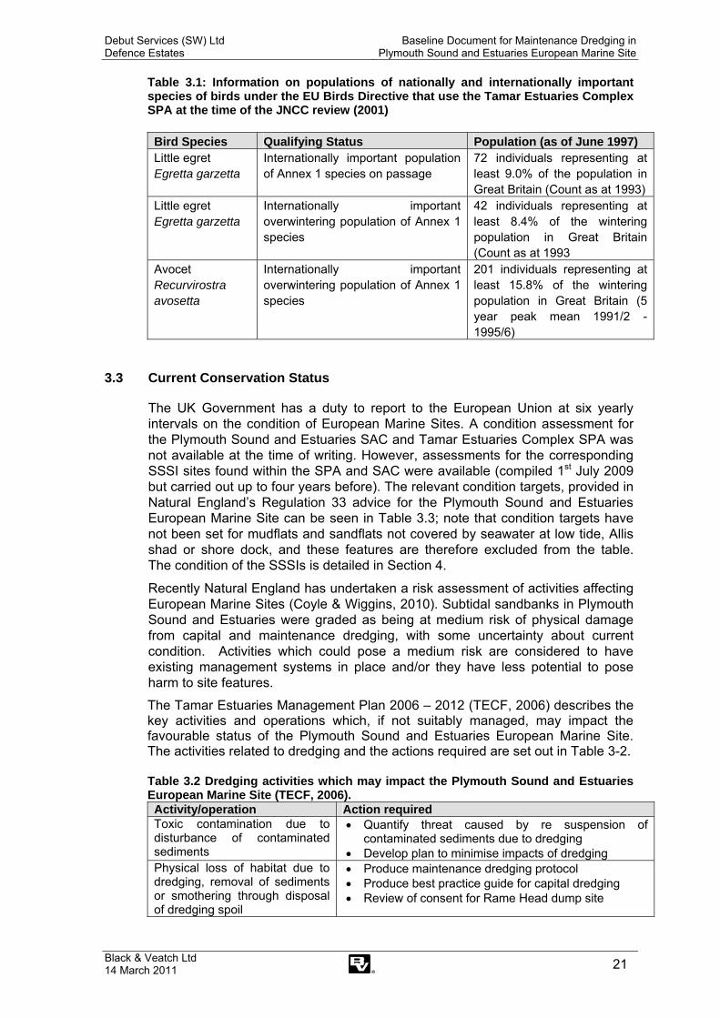
Numbers of birds using these habitats are given in Table 3.1.
Debut Services (SW) Ltd Defence Estates
Baseline Document for Maintenance Dredging in Plymouth Sound and Estuaries European Marine Site
Black & Veatch Ltd 14 March 2011 21
Table 3.1: Information on populations of nationally and internationally important species of birds under the EU Birds Directive that use the Tamar Estuaries Complex SPA at the time of the JNCC review (2001)
Bird Species Qualifying Status Population (as of June 1997) Little egret Egretta garzetta
Internationally important population of Annex 1 species on passage
72 individuals representing at least 9.0% of the population in Great Britain (Count as at 1993)
Little egret Egretta garzetta
Internationally important overwintering population of Annex 1 species
42 individuals representing at least 8.4% of the wintering population in Great Britain (Count as at 1993
Avocet Recurvirostra avosetta
Internationally important overwintering population of Annex 1 species
201 individuals representing at least 15.8% of the wintering population in Great Britain (5 year peak mean 1991/2 - 1995/6)
3.3 Current Conservation Status
The UK Government has a duty to report to the European Union at six yearly intervals on the condition of European Marine Sites. A condition assessment for the Plymouth Sound and Estuaries SAC and Tamar Estuaries Complex SPA was not available at the time of writing. However, assessments for the corresponding SSSI sites found within the SPA and SAC were available (compiled 1st July 2009 but carried out up to four years before). The relevant condition targets, provided in Natural England’s Regulation 33 advice for the Plymouth Sound and Estuaries European Marine Site can be seen in Table 3.3; note that condition targets have not been set for mudflats and sandflats not covered by seawater at low tide, Allis shad or shore dock, and these features are therefore excluded from the table. The condition of the SSSIs is detailed in Section 4.
Recently Natural England has undertaken a risk assessment of activities affecting European Marine Sites (Coyle & Wiggins, 2010). Subtidal sandbanks in Plymouth Sound and Estuaries were graded as being at medium risk of physical damage from capital and maintenance dredging, with some uncertainty about current condition. Activities which could pose a medium risk are considered to have existing management systems in place and/or they have less potential to pose harm to site features.
The Tamar Estuaries Management Plan 2006 – 2012 (TECF, 2006) describes the key activities and operations which, if not suitably managed, may impact the favourable status of the Plymouth Sound and Estuaries European Marine Site. The activities related to dredging and the actions required are set out in Table 3-2. Table 3.2 Dredging activities which may impact the Plymouth Sound and Estuaries European Marine Site (TECF, 2006). Activity/operation Action required Toxic contamination due to disturbance of contaminated sediments
• Quantify threat caused by re suspension of contaminated sediments due to dredging
• Develop plan to minimise impacts of dredging Physical loss of habitat due to dredging, removal of sediments or smothering through disposal of dredging spoil
• Produce maintenance dredging protocol • Produce best practice guide for capital dredging • Review of consent for Rame Head dump site

Debut Services (SW) Ltd Defence Estates
Baseline Document for Maintenance Dredging in Plymouth Sound and Estuaries European Marine Site
Black & Veatch Ltd 14 March 2011 22
It should be emphasised that Table 3.2 is reproduced from TECFs publication and is its proposed actions in response to its (TECF’s) view on the potential impact of dredging activities. It is a matter of routine that all areas in which it is proposed to be dredged are sampled and analysed by CEFAS prior to consent being given for disposal at sea, and in the case of heavily contaminated areas they may be excluded from the consent (such as the maintenance of parts of No3 Wharf Inner) or disposed of on land with strict containment measures (such as the dredging of Deep Water Camber in 2006). Furthermore, the consenting process requires approval of the dredging method.
The consent for the Rame Head marine disposal site is the responsibility of the Marine Management Organisation (formerly Marine and Fisheries Agency) and is reviewed periodically. Whilst available information suggests that there is no impact on the ecological features in the EMS as a result of dredging activities, there is a clear lack of data which assesses impacts of dredging on subtidal features and subfeatures. Future reviews of the baseline document should include any new information on any impacts on the ecological status of the site and their significance, including the relative vulnerability of the subtidal sub features. This would involve assessing if physical damage such as siltation or abrasion, physical loss, toxic and non-toxic contamination is occurring as a result of dredging. Any future conclusions and recommendations should be based on this new information.

Debut Services (SW) Ltd Defence Estates
Baseline Document for Maintenance Dredging in Plymouth Sound and Estuaries European Marine Site
Black & Veatch Ltd 14 March 2011
23
Table 3.3: Favourable condition table for the Plymouth Sound and Estuaries European Marine Site. NB – Many of the attributes will be able to be monitored at the same time or during the same survey The frequency of sampling for many attributes may need to be greater during the first reporting cycle in order to characterise the site and establish the baseline FEATURE SUB-
FEATURE ATTRIBUTE MEASURE TARGET COMMENTS
Large shallow inlet and bay
Extent Area (ha) of the large shallow inlet and bay, measured periodically (frequency to be determined)
No decrease in extent from an established baseline, subject to natural change
Extent is an attribute on which reporting is required by the Habitats Directive The extent of the large shallow inlet and bay will not change significantly over time unless due to some human activity but nevertheless needs to be measured periodically
Water clarity Average light attenuation measured periodically throughout the reporting cycle (frequency to be determined)
Average light attenuation should not deviate significantly from an established baseline
Water clarity is important for maintaining extent and density of algal and plant dominated communities, such as kelp forests and eelgrass beds, and thus the structure of the feature Clarity decreases through increases in amounts of suspended organic/inorganic matter that may arise from activities within the site and in the surrounding catchment area
Water density - temperature - salinity
Regular measurement of water temperature and salinity in the subtidal periodically throughout the reporting cycle
Average temperature/salinity should not deviate significantly from the baseline, subject to natural change
Temperature and salinity are characteristic of the overall hydrography of the area Changes in temperature and salinity influences the presence and distribution of species (along with recruitment processes and spawning behaviour) including those at the edge of their geographic ranges and non-natives

Debut Services (SW) Ltd Defence Estates
Baseline Document for Maintenance Dredging in Plymouth Sound and Estuaries European Marine Site
Black & Veatch Ltd 14 March 2011
24
FEATURE SUB-
FEATURE ATTRIBUTE MEASURE TARGET COMMENTS
Large shallow inlet and bay (cont.)
Intertidal rock and builder shore communities
Distribution of characteristic rocky shore communities
Distribution of intertidal rocky shore communities measured using littoral extent (in particular those biotopes listed at Appendix IV) Measured during summer, once during the reporting cycle
No decrease in littoral extent of range of rocky shore communities from an established baseline, subject to natural change
The relative distribution of the biotopes listed under this sub-feature in Appendix IV is an important structural aspect of the site Changes in extent and distribution may indicate long term changes in the physical conditions at the site
Species composition of low-shore boulder communities
Presence and abundance of composite species from biotope MLRFserFserBo Measured during summer, twice during reporting cycle
Presence and abundance of composite species should not deviate significantly from an established baseline, subject to natural change
The presence and relative abundance of characterising species gives an indication of the quality of MLRFserFserBo (Fucus serratus and under-boulder fauna on lower eulittoral boulders) and change in composition may indicate cyclic change trend in rocky shore communities Change in composition may also indicate changes in hydrography, salinity and or siltation
Species composition of rockpool communities
Presence and abundance of composite species and percentage cover of Sargassum muticum (Japweed) from a representative series of rockpools, measured during summer twice during reporting cycle
Presence and abundance of composite species should not deviate significantly from an established baseline, subject to natural change Average percentage cover of Sargassum should not increase from an established baseline
Composite species of rockpools include many southwestern species, their relative abundance gives an indication of the quality of the rockpools and are key structural components of the intertidal rocky shores Increased Sargassum is believed to compete with native species and would thus be detrimental to favourable condition

Debut Services (SW) Ltd Defence Estates
Baseline Document for Maintenance Dredging in Plymouth Sound and Estuaries European Marine Site
Black & Veatch Ltd 14 March 2011
25
FEATURE SUB-
FEATURE ATTRIBUTE MEASURE TARGET COMMENTS
Large shallow inlet and bay (cont.)
Subtidal rocky reef communities
Distribution of characteristic biotopes
Distribution of the limestone biotopes SubSoAs and AlcByHHia Measured during summer, once during reporting cycle
Average distribution should not deviate significantly from an established baseline, subject to natural change
The biotopes SubSoAs and AlcByHHia are key structural components of the subtidal limestone and are of particular nature conservation importance due to the unusual physical conditions These biotopes have species rich communities which contribute to the structure of the subtidal rocky reef communities
Species composition of characteristic biotopes
Presence and abundance of composite species from biotopes, AlcByHHia, AlcTub, ErSEun, SubSoAs Measured during summer once during reporting cycle
Presence and abundance of composite species should not deviate significantly from an established baseline, subject to natural change
Species composition is an important contributor to the structure of the biotope and thus of the reef as a whole The presence and relative abundance of characterising species gives an indication of the quality of the biotopes and changes in composition may indicate cyclic change/trend in communities One of the characterising species is Eunicella, which is a long-lived and nationally important species
Kelp forest communities
Algal species composition
Presence and abundance of composite of algal species from kelp zone Measured during summer, twice during reporting cycle
Presence and abundance should not deviate significantly from an established baseline, subject to natural change
Changes in the floral composition within the kelp forests may serve as long-term indicators of change in water clarity, temperature or wave exposure Red Algae act as a indicator of reductions in entire algal population
Debut Services (SW) Ltd Defence Estates
Baseline Document for Maintenance Dredging in Plymouth Sound and Estuaries European Marine Site
Black & Veatch Ltd 14 March 2011
26
FEATURE SUB-
FEATURE ATTRIBUTE MEASURE TARGET COMMENTS
Large shallow inlet and bay (cont.)
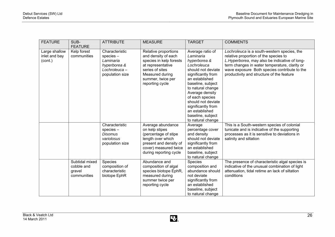
Kelp forest communities
Characteristic species – Laminaria hyperborea & Lochroleuca – population size
Relative proportions and density of each species in kelp forests at representative series of sites Measured during summer, twice per reporting cycle
Average ratio of Laminaria hyperborea & Lochroleuca should not deviate significantly from an established baseline, subject to natural change Average density of each species should not deviate significantly from an established baseline, subject to natural change
Lochroleuca is a south-western species, the relative proportion of the species to L.Hyperborea, may also be indicative of long-term changes in water temperature, clarity or wave exposure Both species contribute to the productivity and structure of the feature
Characteristic species – Disomus variolosus population size
Average abundance on kelp stipes (percentage of stipe length over which present and density of cover) measured twice during reporting cycle
Average percentage cover and density should not deviate significantly from an established baseline, subject to natural change
This is a South-western species of colonial tunicate and is indicative of the supporting processes as it is sensitive to deviations in salinity and siltation
Subtidal mixed cobble and gravel communities
Species composition of characteristic biotope EphR
Abundance and composition of algal species biotope EphR, measured during summer twice per reporting cycle
Species composition and abundance should not deviate significantly from an established baseline, subject to natural change
The presence of characteristic algal species is indicative of the unusual combination of light attenuation, tidal retime an lack of siltation conditions

Debut Services (SW) Ltd Defence Estates
Baseline Document for Maintenance Dredging in Plymouth Sound and Estuaries European Marine Site
Black & Veatch Ltd 14 March 2011
27
FEATURE SUB-
FEATURE ATTRIBUTE MEASURE TARGET COMMENTS
Large shallow inlet and bay (cont.)
Subtidal mud communities
Species composition of biotope IMUPhiVir
Presence and abundance of composite species from biotope IMUPhiVir Measured during summer, once during reporting cycle
Presence and abundance should not deviate significantly from an established baseline, subject to natural change
Species composition is an important contributor to the structure of IMUPhiVir The presence and relative abundance of characterising species gives an indication of the quality of an change in composition may indicate cyclic change/trend in sediment communities
Subtidal sandbank communities
Attributes and targets for this sub-feature are listed under the ‘Subtidal sandbanks’ interest feature covered in other sections of this table
Estuaries Extent Area (ha) of the estuaries measured periodically (frequency to be determined)
No decrease in extent from an established baseline, subject to natural change
Extent is an attribute on which reporting is required by the Habitats Directive The extent of the estuaries will not change significantly over time unless due to some human activity but nevertheless needs to be measured periodically
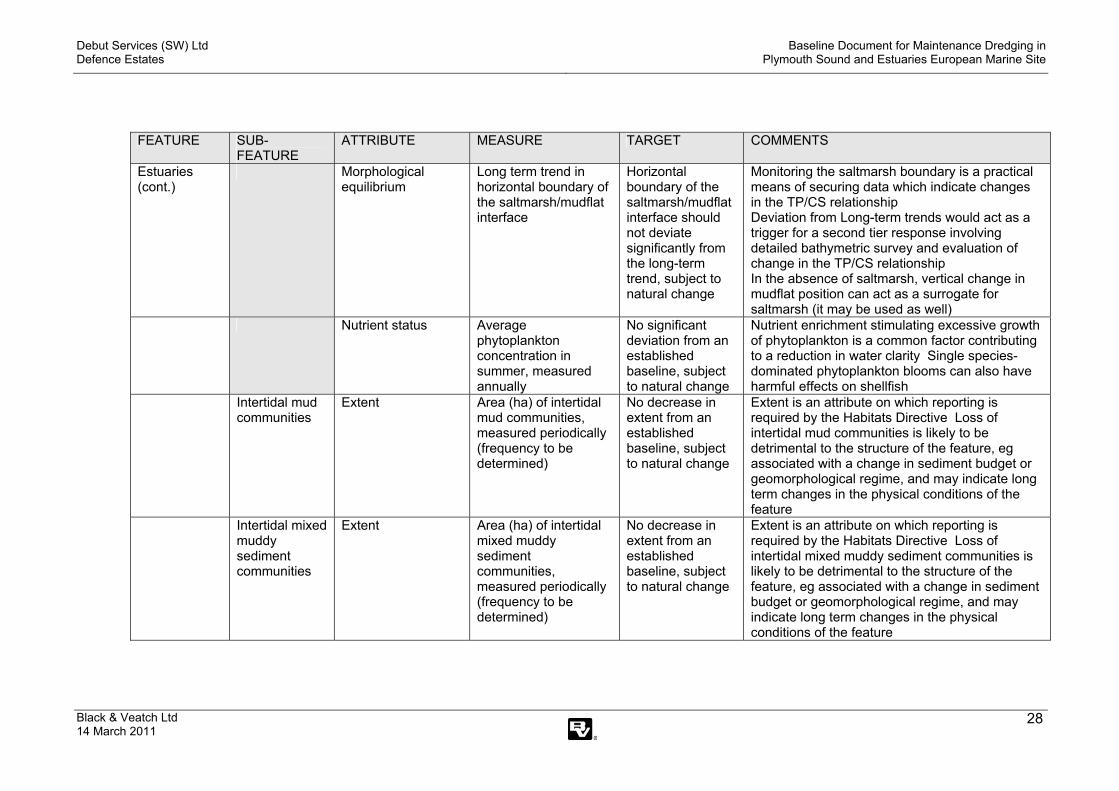
Morphological equilibrium
Intra- and inter-estuarine Tidal Prism/Cross-Section ratio (TP/CS ratio), measured periodically (frequency to be determined)
Intra- and inter-estuarine TP/CS ratio should not deviate significantly from an established baseline, subject to natural change
TP = Tidal Prism = total volume of water crossing a given profile during the flood tide (m3) CS = Cross-sectional area of a given profile (location) at high water springs in m2 The relationship between TP and CS provides a measure of the hydrodynamics of the estuary which are fundamental to the way the estuary adjusts to tidal energy reflected in rates of deposition and erosion Substantial change in this relationship may indicate that anthropogenic factors are taking effect and this would trigger more detailed evaluation of potential problems
Debut Services (SW) Ltd Defence Estates
Baseline Document for Maintenance Dredging in Plymouth Sound and Estuaries European Marine Site
Black & Veatch Ltd 14 March 2011
28
FEATURE SUB-
FEATURE ATTRIBUTE MEASURE TARGET COMMENTS
Estuaries (cont.)
Morphological equilibrium
Long term trend in horizontal boundary of the saltmarsh/mudflat interface
Horizontal boundary of the saltmarsh/mudflat interface should not deviate significantly from the long-term trend, subject to natural change
Monitoring the saltmarsh boundary is a practical means of securing data which indicate changes in the TP/CS relationship Deviation from Long-term trends would act as a trigger for a second tier response involving detailed bathymetric survey and evaluation of change in the TP/CS relationship In the absence of saltmarsh, vertical change in mudflat position can act as a surrogate for saltmarsh (it may be used as well)
Nutrient status Average phytoplankton concentration in summer, measured annually
No significant deviation from an established baseline, subject to natural change
Nutrient enrichment stimulating excessive growth of phytoplankton is a common factor contributing to a reduction in water clarity Single species-dominated phytoplankton blooms can also have harmful effects on shellfish
Intertidal mud communities
Extent Area (ha) of intertidal mud communities, measured periodically (frequency to be determined)
No decrease in extent from an established baseline, subject to natural change
Extent is an attribute on which reporting is required by the Habitats Directive Loss of intertidal mud communities is likely to be detrimental to the structure of the feature, eg associated with a change in sediment budget or geomorphological regime, and may indicate long term changes in the physical conditions of the feature
Intertidal mixed muddy sediment communities
Extent Area (ha) of intertidal mixed muddy sediment communities, measured periodically (frequency to be determined)
No decrease in extent from an established baseline, subject to natural change
Extent is an attribute on which reporting is required by the Habitats Directive Loss of intertidal mixed muddy sediment communities is likely to be detrimental to the structure of the feature, eg associated with a change in sediment budget or geomorphological regime, and may indicate long term changes in the physical conditions of the feature

Debut Services (SW) Ltd Defence Estates
Baseline Document for Maintenance Dredging in Plymouth Sound and Estuaries European Marine Site
Black & Veatch Ltd 14 March 2011
29
FEATURE SUB-
FEATURE ATTRIBUTE MEASURE TARGET COMMENTS
Estuaries (cont.)
Subtidal mud communities
Extent Area (ha) of subtidal mud communities, measured periodically (frequency to be determined)
No decrease in extent from an established baseline, subject to natural change
Extent is an attribute on which reporting is required by the Habitats Directive Loss of subtidal mud communities is likely to be detrimental to the structure of the feature, eg leading to associated loss of intertidal sediments, and may indicate long term changes in the physical conditions of the feature
Subtidal mixed muddy sediment communities
Extent Area (ha) of subtidal mixed muddy communities, measured periodically (frequency to be determined)
No decrease in extent from an established baseline, subject to natural change
Extent is an attribute on which reporting is required by the Habitats Directive Loss of subtidal mixed sediment communities is likely to be detrimental to the structure of the feature, eg leading to associated loss of intertidal sediments, and may indicate long term changes in the physical conditions of the feature
Extent and distribution of characteristic biotopes (CuSH, HarCon as identified at Appendix IV)
Extent and distribution of biotopes (CuSH, HarCon), measured once during reporting cycle
Extent and distribution of biotopes should not deviate significantly from an established baseline, subject to natural change
The extent of these biotopes and their relative distribution is an important structural aspect of the feature Changes in their extent and distribution may indicate long term changes in the physical conditions of the estuarine complex
Estuarine bedrock, boulder and cobble communities
Extent and distribution of characteristic biotopes (SIRCorEle – LsacRSFiR as identified at Appendix IV)
Extent and distribution of biotopes (SIRCorEle – LsacRSFiR) measured during summer, once during reporting cycle
Extent and distribution of CorEle and LsacRSFiR should not deviate significantly from an established baseline, subject to natural change
The extent of these biotopes contributes to the structure of the estuaries, and changes in distribution may indicate long term changes in the physical conditions of the estuarine complex such as changes in salinity gradients or siltation patterns

Debut Services (SW) Ltd Defence Estates
Baseline Document for Maintenance Dredging in Plymouth Sound and Estuaries European Marine Site
Black & Veatch Ltd 14 March 2011
30
FEATURE SUB-
FEATURE ATTRIBUTE MEASURE TARGET COMMENTS
Estuaries (cont.)
Subtidal sandbank communities
Attributes and targets for this sub-feature are listed under the ‘Subtidal sandbanks’ interest feature covered in other sections of this table
Saltmarsh communities
Extent Area (ha) of saltmarsh communities measured once during the reporting cycle
No decrease in extent of saltmarsh communities from an established baseline, subject to natural change
Monitoring will need to take account of the dynamic nature of some of these habitats A reduction in extent could be further indicated by ground survey to assess for signs of erosion-toppled vegetated blocks; stepping of saltmarsh edge; signs of stress/damage to plants Extent needs to be measured at low tide
Creek patterns Creek density and morphology measured periodically during reporting cycle (frequency to be determined)
No alteration of creek patterns from an established baseline, subject to natural change
Creeks absorb tidal energy and assist with the delivery of sediment into saltmarshes The efficiency of this process depends on creek pattern Density is controlled by vegetation cover, suspended sediment load and tidal influence Creeks allow pioneer vegetation to be established along their banks higher into the saltmarsh system
Range and distribution of characteristic saltmarsh communities (NVC communities listed in Appendix V)
Range and distribution of characteristic saltmarsh communities measured once per reporting cycle
Range and distribution of characteristic saltmarsh communities should not deviate significantly from an established baseline, subject to natural change
Sites with the greatest range of community types considered typical for the site from low, mid to upper saltmarsh and transition to other habitats are in most favourable condition
Debut Services (SW) Ltd Defence Estates
Baseline Document for Maintenance Dredging in Plymouth Sound and Estuaries European Marine Site
Black & Veatch Ltd 14 March 2011
31
FEATURE SUB-
FEATURE ATTRIBUTE MEASURE TARGET COMMENTS
Estuaries (cont.)
Saltmarsh communities (cont)
Characterising species of characteristic saltmarsh communities (NVC communities listed in Appendix V)
Frequency and abundance of characterising species of characteristic communities measured once during reporting cycle
Frequency and abundance of characteristic species should not deviate significantly from an established baseline, subject to natural change
Species composition of characteristic saltmarsh communities is an important indicator of favourable condition of the sub-feature
Reedbed communities
Extent Area (ha) of reedbed communities measured once every reporting cycle
No decrease in extent of reedbed plant communities from an established baseline, subject to natural change
Important transitional habitat, loss of which will have impacts on other species, including juvenile fish and birds such as the little egret
Subtidal sandbanks
Extent Area (ha) of subtidal sandbank communities measured periodically (frequency to be determined)
No decrease in extent from an established baseline, subject to natural change
Extent of the feature is a reporting requirement of the Habitats Directive Monitoring will need to take account of the dynamic nature of the feature but reduction in extent may indicate long term changes in the physical conditions influencing the feature

Debut Services (SW) Ltd Defence Estates
Baseline Document for Maintenance Dredging in Plymouth Sound and Estuaries European Marine Site
Black & Veatch Ltd 14 March 2011
32
FEATURE SUB-
FEATURE ATTRIBUTE MEASURE TARGET COMMENTS
Subtidal sandbanks (cont.)
Sediment character
Particle size analysis (PSA) Parameters include percentage sand/silt/gravel, mean and median grain size, and sorting coefficient, used to characterise sediment type Sediment character to be measured during summer, once during reporting cycle
Average PSA parameters should not deviate significantly from an established baseline, subject to natural change
Sediment character defined by particle size analysis is key to the structure of the feature, and reflects all of the physical processes acting on it Particle size composition varies across the feature and can be used to indicate spatial distribution of sediment types thus reflecting the stability of the feature and the processes supporting it
Topography Depth distribution of sandbanks from selected sites, measured periodically (frequency to be determined)
Depth should not deviate significantly from an established baseline, subject to natural change
Depth and distribution of the sandbanks reflects the energy conditions and stability of the sediment, which is key to the structure of the feature Depth of the feature is a major influence on the distribution of communities throughout
Eelgrass bed communities
Extent Area (ha) of eelgrass bed communities measured during peak growth period twice during reporting cycle
No decrease in extent from an established baseline, subject to natural change
The extent and distribution of seagrass beds provides a long-term integrated measure of environmental conditions
Water clarity Average light attenuation measured periodically throughout the reporting cycle (frequency to be determined)
Average light attenuation should not decrease significantly from an established baseline, subject to natural change
Water clarity is important for maintaining the eelgrass beds, and thus the structure of the feature Clarity decreases through increases in amounts of suspended organic/inorganic matter Water clarity is already being measured in the shallow inlets and bays feature, but has to be measured on all eelgrass beds
Debut Services (SW) Ltd Defence Estates
Baseline Document for Maintenance Dredging in Plymouth Sound and Estuaries European Marine Site
Black & Veatch Ltd 14 March 2011
33
FEATURE SUB-
FEATURE ATTRIBUTE MEASURE TARGET COMMENTS
Subtidal sandbanks (cont.)
Eelgrass bed communities (cont)
Characteristic species-density of Zostera marina
Average density, measured during peak growth period twice during reporting cycle
Average density should not deviate significantly from an established baseline, subject to natural change
An early indicator of seagrass under stress is a reduction in biomass, ie the number and length of leaves Density is preferred as a surrogate for biomass, being less destructive, based on baseline survey to establish the relationship between density and biomass at a site
Characteristic species – epiphytic community
Presence and abundance of epiphytic species measured during summer twice during reporting cycle
Presence and abundance of epiphytic species should not deviate significantly from an established baseline, subject to natural change
The occurrence and frequency of epiphytes is indicative of the structure of the eelgrass bed communities It gives an indication of their quality and changes in epiphytic composition may indicate cyclic change/trend in the host biotope or the subtidal sandbank communities as a whole
Nutrient status – green algal mat
Extent across whole or parts of site, measured during peak growth period every 3 years during reporting cycle
No increase in extent of green algal mats from an established baseline, subject to natural change
Nutrient status is a key functional factor that influences the sub-feature as opportunistic macroalgae compete with seagrass and affect the associated species Increase in filamentous green algae may be a related natural phenomenon or may indicate eutrophication
Gravel and sand communities
Species composition of characteristic biotopes
Presence and abundance of composite species from biotopes IGSSell & IMSEcorEns Measured during summer, once during reporting cycle
Presence and abundance of composite species should not deviate significantly from an established baseline, subject to natural change
Species composition is an important contributor to the structure of IGSSell & IMSEcorEns The presence and relative abundance of characterising species gives an indication of the quality of the biotopes and change in composition may indicate cyclic change/trend in subtidal sandbank communities

Debut Services (SW) Ltd Defence Estates
Baseline Document for Maintenance Dredging in Plymouth Sound and Estuaries European Marine Site
Black & Veatch Ltd 14 March 2011
34
FEATURE SUB-
FEATURE ATTRIBUTE MEASURE TARGET COMMENTS
Subtidal sandbanks (cont.)
Muddy sand communities
Species composition of characteristic biotope
Presence and abundance of composite species from biotope IMSMacAbr Measured during summer, once during reporting cycle
Presence and abundance of composite species should not deviate significantly from an established baseline, subject to natural change
Species composition is an important contributor to the structure of IMSMacAbr The presence and relative abundance of characterising species gives an indication of the quality of the biotopes and change in composition may indicate cyclic change/trend in subtidal sandbank communities
Nationally important Annex 1 bird populations (avocet Recurvirostra avosetta)
Intertidal mudflat communities and mixed muddy sediment communities
Extent Area (ha) of intertidal mudflat communities and mixed muddy sediment communities, measured periodically (frequency to be determined)
No decrease in extent of intertidal sediment communities from an established baseline, subject to natural change
Important feeding areas
Presence and abundance of prey species
Presence and abundance of prey species measured periodically (frequency to be determined)
Presence and abundance of prey species should not deviate significantly from an established baseline, subject to natural change
Important prey species include insects, crustaceans, small fish or worms found in clear water, on mud surfaces or in soft sediments Suitable prey size up to 15mm (or large for thin worms)
Saltmarsh communities
Extent Area (ha) of saltmarsh communities, measured periodically (frequency to be determined)
No decrease in extent of saltmarsh from an established baseline, subject to natural change
Important roosting areas

Debut Services (SW) Ltd Defence Estates
Baseline Document for Maintenance Dredging in Plymouth Sound and Estuaries European Marine Site
Black & Veatch Ltd 14 March 2011
35
FEATURE SUB-
FEATURE ATTRIBUTE MEASURE TARGET COMMENTS
Nationally important Annex 1 bird populations (avocet Recurvirostra avosetta) (cont.)
Saltmarsh communities (cont)
Disturbance in feeding and roosting areas
Reduction or displacement of birds measured using 5 year peak mean information
No significant reduction in numbers or displacement of birds from an established baseline, subject to natural change
Significant disturbance attributable to human activities can result in reduced food intake and / or increased energy expenditure Five year peak mean information on populations will be used as the basis for assessing whether disturbance is damaging
Nationally important Annex 1 bird populations (little egret Egretta garzetta)
Intertidal mudflat communities and intertidal mixed muddy sediment communities
Extent Area (ha) of intertidal mudflat communities and intertidal mixed muddy sediment communities, measured periodically (frequency to be determined)
No decrease in extent of intertidal sediment from an established baseline, subject to natural change
Important feeding areas
Presence and abundance of prey species
Presence and abundance of prey species measured periodically (frequency to be determined)
Presence and abundance of prey species should not deviate significantly from an established baseline, subject to natural change
Important prey species include fish, amphibians, and/or large aquatic insects Suitable prey size less than 15cm
Saltmarsh communities
Extent Area (ha) of saltmarsh communities, measured periodically (frequency to be determined)
No decrease in extent of saltmarsh from an established baseline, subject to natural change
Important feeding and roosting areas

Debut Services (SW) Ltd Defence Estates
Baseline Document for Maintenance Dredging in Plymouth Sound and Estuaries European Marine Site
Black & Veatch Ltd 14 March 2011
36
FEATURE SUB-
FEATURE ATTRIBUTE MEASURE TARGET COMMENTS
Nationally important Annex 1 bird populations (little egret Egretta garzetta) (cont.)
Saltmarsh communities (cont)
Presence and abundance of prey species
Presence and abundance of prey species measured periodically (frequency to be determined)
Presence and abundance of prey species should not deviate significantly from an established baseline, subject to natural change
Important prey species include fish, amphibians, and/or large aquatic insects Suitable prey size less than 15cm
Disturbance in feeding and roosting areas
Reduction or displacement or birds measured using 5 year peak mean information
No significant reduction in numbers or displacement or birds from an established baseline, subject to natural change
Significant disturbance attributable to human activities can result in reduced food intake and / or increased energy expenditure Five year peak mean information on populations will be used as the basis for assessing whether disturbance is damaging
NB Extreme events (such as storms reducing or increasing salinities, exceptionally cold winters or warm summers) also need to be recorded as they may be critical in influencing ecological issues in Plymouth Sound and Estuaries European Marine Site and may well be missed by routine monitoring
Debut Services (SW) Ltd Defence Estates
Baseline Document for Maintenance Dredging in Plymouth Sound and Estuaries European Marine Site
Black & Veatch Ltd 14 March 2011
37
4 SITES OF SPECIAL SCIENTIFIC INTEREST
4.1 Introduction
Although the condition assessments of SSSIs will not strictly be for the European designated sites, they are considered to be relevant as several SSSIs cover the same area as the Plymouth Sound and Estuaries European Marine Site. As a result, they share some of the same interest features. For example, both the Tamar Estuaries Complex SPA and the Tamar-Tavy Estuary SSSI are designated for supporting nationally and internationally important numbers of Avocet.
Each site is provided with a list of "operations that are likely to damage the special interest" or Operation Likely to Damage (OLD). As part of this section, those OLD’s relevant to coastal civil engineering and dredging operations are listed for each site. It should be noted that whilst the reference numbers for each SSSI may be identical, the description of the OLD may vary to reflect the site features. Hence the relevant OLD’s have been provided in full for each site.
SSSIs are divided up into management units so their requirements to reach a favourable status can be tailored for on an individual basis. For each of these units Natural England has assessed their condition according to a number of criteria and assigned them a term which best represents the unit in question. The terms are defined in Table 4.1. The location of SSSIs within the Plymouth Sound and Estuaries European Marine Site are shown in Figure 4-1. Table 4.1: Definition of SSSI condition assessment terms (Natural England, 2009).
Term Description Favourable Favourable condition means that the SSSI land is being
adequately conserved and is meeting its 'conservation objectives'; however, there is scope for the enhancement of these sites.
Unfavourable recovering
Unfavourable recovering condition is often known simply as 'recovering'. SSSI units are not yet fully conserved but all the necessary management measures are in place. Provided that the recovery work is sustained, the SSSI will reach favourable condition in time.
Unfavourable no change
This means the special interest of the SSSI unit is not being conserved and will not reach favourable condition unless there are changes to the site management or external pressures. The longer the SSSI unit remains in this poor condition, the more difficult it will be, in general, to achieve recovery.
Unfavourable declining
This means that the special interest of the SSSI unit is not being conserved and will not reach favourable condition unless there are changes to site management or external pressures. The site condition is becoming progressively worse.
Part destroyed Part destroyed means that lasting damage has occurred to part of the special conservation interest of a SSSI unit such that it has been irretrievably lost and will never recover. Conservation work may be needed on the residual interest of the land.
Destroyed Destroyed means that lasting damage has occurred to all the special conservation interest of the SSSI unit such that it has been irretrievably lost. This land will never recover.

Debut Services (SW) Ltd Defence Estates
Baseline Document for Maintenance Dredging in Plymouth Sound and Estuaries European Marine Site
Black & Veatch Ltd 14 March 2011
38
Figure 4-1: SSSI units and condition assessment.

Debut Services (SW) Ltd Defence Estates
Baseline Document for Maintenance Dredging in Plymouth Sound and Estuaries European Marine Site
Black & Veatch Ltd 14 March 2011
39
The following descriptions relate to the SSSIs within the Plymouth Sound and Estuaries European Marine Site (as shown in Figure 4-1).
4.2 Tamar-Tavy Estuary Site of Special Scientific Interest
4.2.1 Overview
This site comprises the upper reaches of the Tamar Estuary system which includes the Lynher Estuary SSSI and St. John’s Lake SSSI. The Tamar-Tavy Estuary is designated as it supports more than 20% of the British wintering population of the uncommon Avocet (an Annex I species of the EC Council Directive on the Conservation of Wild Birds). Other species of passage or wintering wading birds for which the Tamar complex as a whole is important for include Limosa limosa (Black-tailed Godwit), Tringa tetanus (Redshank), Calidris alpina (Dunlin) and Numenius phaeopus (Whimbrel). Tringa nebularia (Greenshank), T. erythropus (Spotted Redshank) and T. ochropus (Green Sandpiper) all uncommon wintering species in Britain, together with large numbers of Pluvialis apricaria (Golden Plover) (an Annex I species) are dependent on parts of the SSSI in winter.
The site also encompasses a section of the River Tamar that is considered to be of national significance for its marine biological interest. The River Tamar’s rocky shore and sub-tidal habitats support communities that are considered to be the best examples of their type in tidal inlets of Southern Britain and are the only known examples in South West Britain. Some of the species include dense populations of the hydroid Cordylophora lacustris and the occurrence of the prawn Palaemon longirostris near Calstock.
Two nationally scarce species of grass are known from the site; Puccinellia rupestris (Stiff saltmarsh-grass) and Alopecurus bulbosus (Bulbous Fox-tail). Other plants of interest associated with the estuarine margins include Ruppia maritima (Beaked Tasselweed), Orobanche maritima (Carrot Broomrape) and Artiplex littoralis (Grass-leaved Orache) (it’s only recorded site in Devon). Several areas of semi-natural woodland of ancient character are included in the site. Lutra lutra (Otter) (protected species) and Alcedo atthis (Kingfisher) (Annex I species) are among the many animals dependant on the undisturbed stretches of river.
4.2.2 Current Conservation Status
The Tamar-Tavy estuary SSSI is made up of 62 management units. In general the SSSI is in a favourable condition (91.96%) and consequently 99.45% of the area is reaching the required management targets. The main issues potentially affecting the condition of the site were the presence of non-native plants. Some SSSI units had >5% of any of the tree layers comprising non-native species whilst other units featured invasive species such as Giant Hogweed, Japanese Knotweed and Rhododendron. Fly tipping and increased accessibility to the public were amongst other issues, but overall where the site is not already in a favourable condition, it is perceived to be recovering. The full results of the condition assessments can be found in Appendix I, a summary is given in Table 4.2.

Debut Services (SW) Ltd Defence Estates
Baseline Document for Maintenance Dredging in Plymouth Sound and Estuaries European Marine Site
Black & Veatch Ltd 14 March 2011
40
Table 4.2: Tamar-Tavy estuary SSSI condition summary (1st June 2009).
Relevant Operations Likely to Damage (OLDs) the special interest include (as stated in OLD1005917):
• Dumping, spreading or discharge of any materials (Ref. No. 7); • Modifications of the structure of watercourses, including their banks and
beds, as by re-alignment, regrading or dredging (Ref. No. 13b); • The changing of water levels and tables and water utilisation (Ref No.
14); • Infilling of marshes (Ref. No. 15); • Reclaiming of land from estuary or marsh (Ref. No. 17); • Erection of permanent or temporary structures, or the undertaking of
engineering works including drilling (Ref. No. 23); and • Modification of natural or man-made features (including cave entrances)
and clearance of boulders, large stones, loose rocks or scree (Ref. No. 24).
4.3 Lynher Estuary Site of Special Scientific Interest
4.3.1 Overview
The Lynher Estuary forms the Western arm of the Tamar-Tavy-Lynher drowned river valley (ria) complex lying to the west/ northwest of Plymouth. The estuary has developed fairly extensive saltmarsh which together with the adjacent highly productive mud flats provide important feeding and roosting grounds for large populations of wintering wildfowl and waders. Important populations of the nationally rare Alopecurus bulbosus (Bulbous Foxtail) also thrive here.
The Tamar-Tavy-Lynher complex is of national importance for its wintering populations of around 6,000 wildfowl and 10,000 waders. The extensive Lynher Estuary marsh system provides important roosting areas for up to 5,000 Anas Penelope (Wigeon) which feed on the Zostera spp (eel grass) beds on nearby St. John’s Lake. High numbers of Anas crecca (Teal), A. platyrhynchos (Mallard), Tadona tadorna (Shelduck) and Anas acuta (Pintail) all occur here along with a nationally important population of Black-tailed Godwit which regularly winter in numbers up to 150 (3-4% of the British wintering population). Other waders which feed on the productive mud flats include up to 5,000 Dunlin 899 Numenius arquata (Curlew), 500 Haematopus ostralegus (Oystercatchers) and 200 Redshank.
Cygnus olor (Mute Swan), Ardea cinerea (Grey Heron), Shelduck and Mallard all breed here. In addition there is a large gull roost of up to 4,000 Larus ridibundus (Black-headed Gulls). Arcenaris interpres (Turnstone), Pluvialis squatarola (Grey Plover), Charadrius hiaticula (Ringed Plover) and Spotted Redshank also frequent the site.
% Area meeting PSA target
% Area favourable
% Area unfavourable recovering
% Area unfavourable no change
% Area unfavourable declining
% Area destroyed / part destroyed
99.45% 91.96% 7.49% 0.29% 0.26% 0.00%

Debut Services (SW) Ltd Defence Estates
Baseline Document for Maintenance Dredging in Plymouth Sound and Estuaries European Marine Site
Black & Veatch Ltd 14 March 2011
41
4.3.2 Current Conservation Status
The Lynher Estuary SSSI is made up of 26 management units, all of which are in a favourable condition according to the last assessment. A summary of SSSI unit condition is given in Table 4.3 below (SSSI units’ last assessment dates range from 2001-2009). The full condition assessment can be seen in Appendix II.
Table 4.3: Lynher Estuary SSSI Condition Summary Table.
Relevant Operations Likely to Damage the special interest include (as stated in OLD1004001):
• Dumping, spreading or discharge of any materials (Ref. No. 7); • Modifications of the structure of watercourses, including their banks and
beds, as by re-alignment, regrading or dredging (Ref. No. 13b); • The changing of water levels and tables and water utilisation (Ref. No.
14); • Reclaiming of land from estuary or marsh (Ref. No. 17); • Erection of sea defences or coastal protection works (Ref. No. 19); • Extraction of minerals, including shingle, sand, gravel and shells (Ref.
No. 20); • Erection of permanent or temporary structures, or the undertaking of
engineering works including drilling (Ref. No. 23); and • Modification of natural or man-made features, clearance of boulders,
large stones, loose rock or scree and battering, buttressing or grading rock-faces and cuttings, infilling of pits and quarries (Ref. No. 24).
4.4 St. John’s Lake Site of Special Scientific Interest
4.4.1 Overview
St. John’s Lake SSSI lies immediately south of Torpoint and forms part of the Tamar-Lynher estuarine system. It is of national importance and designated under the Wildlife and Countryside Act 1981 (as updated by the Countryside and Rights of Way Act 2000) for its wintering population of around 6,000 wildfowl and 10,000 waders. The alga and eel grass beds are particularly important as they provide feeding areas for large populations of up to 5,000 widgeon. The soft mud flats also attract a nationally important population of Black-tailed Godwit which regularly winter in numbers up to 150 (3-4% of the British wintering population). Some 3,000 Dunlin, 600 C. canutus (knot), 300 oystercatchers, 200 curlew and 600 redshank also use the mudflats as an important feeding ground.
4.4.2 Current Conservation Status
St. John’s Lake SSSI is made up of three units, all of which were deemed to be in a favourable condition at their last assessments in 2001 and 2002 (see Table 4.4). The full condition assessment can be seen in Appendix III.
% Area meeting PSA target
% Area favourable
% Area unfavourable recovering
% Area unfavourable no change
% Area unfavourable declining
% Area destroyed / part destroyed
100.00% 100.00% 0.00% 0.00% 0.00% 0.00%

Debut Services (SW) Ltd Defence Estates
Baseline Document for Maintenance Dredging in Plymouth Sound and Estuaries European Marine Site
Black & Veatch Ltd 14 March 2011
42
Table 4.4: St John’s Lake SSSI Condition Summary Table.
Relevant Operations Likely to Damage the special interest include (as stated in OLD1000512):
• Dumping, spreading or discharge of any materials (Ref. No. 7); • Modifications of the structure of watercourses, including their banks and
beds, as by re-alignment, regrading or dredging (Ref. No. 13b); • The changing of water levels and tables and water utilisation (Ref. No.
14); • Infilling of marshes (Ref. No. 15); • Reclaiming of land from estuary or marsh (Ref. No. 17); • Erection of sea defences or coastal protection works (Ref. No. 19); • Extraction of minerals, including shingle, sand, gravel and shells (Ref.
No. 20); and • Erection of permanent or temporary structures, or the undertaking of
engineering works including drilling (Ref. No. 23).
4.5 Yealm Estuary Site of Special Scientific Interest
4.5.1 Overview
The Yealm is an example of a ria, or drowned river valley, which shows a transition to estuarine conditions in its upper reaches. There is a diverse range of biological communities, reflecting the influence of marine conditions far up the inlet. In the middle reaches of the inlet there is a well established zonation of biological communities down the shore. Where a mixed sediment of muddy shingle occurs there are extensive areas of a rich and nationally uncommon community dominated by the Hymeniacidon perleve (orange peel sponge) and Sabella pavonina (peacock worm).
Mudflats of varying width characterised by Hediste diversicolor (ragworm) and patches of Arenicola marina (lugworm) extend into the main channel. Mudflats are extensive particularly north-east of Broad Oooze, the area upstream of which almost completely dries at low water. At the top of the inlet the mudflats are backed by a small area of saltmarsh. Seaweed zones are present in several of the SSSI sections and support a variety of animal species.
4.5.2 Current Conservation Status
The Yealm Estuary SSSI is made up of three management units, all of which were in favourable condition as of Oct/Nov 2004. A summary is provided in Table 4.5 and the full condition assessment in Appendix IV.
% Area meeting PSA target
% Area favourable
% Area unfavourable recovering
% Area unfavourable no change
% Area unfavourable declining
% Area destroyed / part destroyed
100.00% 100.00% 0.00% 0.00% 0.00% 0.00%

Debut Services (SW) Ltd Defence Estates
Baseline Document for Maintenance Dredging in Plymouth Sound and Estuaries European Marine Site
Black & Veatch Ltd 14 March 2011
43
Table 4.5: Yealm Estuary SSSI Condition Summary Table.
% Area meeting PSA target
% Area favourable
% Area unfavourable recovering
% Area unfavourable no change
% Area unfavourable declining
% Area destroyed / part destroyed
100% 100% 0% 0% 0% 0%
Relevant Operations Likely to Damage the special interest include (as stated in OLD2000131):
• Dumping, spreading or discharge of any materials (Ref. No. 7); • Destruction, displacement, removal or cutting of any plant or plant
remains including seaweeds (Ref. No. 11); • Alterations to water levels and tables and water utilisation (Ref. No.14); • Digging of marshes (Ref. No. 15); • Reclaiming of land from sea, estuary or marsh (Ref. No. 17); • Erection and repair of sea defences or coastal protection works,
including cliff or landslip drainage or stabilisation measures (Ref. No. 19);
• Extraction of minerals, including shingle, sand, gravel and shells (Ref. No. 20);
• Erection of permanent or temporary structures, or the undertaking of engineering works including drilling (Ref. No. 23); and
• Modification of natural or man-made features (including cave entrances) and clearance of boulders, large stones, loose rocks or scree (Ref. No. 24a).
4.6 Western King Site of Special Scientific Interest
4.6.1 Overview
This section of cliff contains an important fauna of microfossils known as conodonts, which are used to subdivide the rock sequence and relate it to comparable sequences elsewhere. Of particular interest is the occurrence of laminated sediment which infills solutional cavities within the Frasnian limestones. As the exact process of formation of the infill is not yet fully understood, the site is of importance for further research purposes. The site also includes an area of amenity grassland and scrub within which colonies of a nationally rare plant Eryngium campestre (Field Eryngo) occurs. It is listed on Schedule 8 of the Wildlife and Countryside Act 1981 which stipulates that it is an offence if the plant is picked, uprooted or destroyed.
4.6.2 Current Conservation Status
The Western King SSSI is one management unit which was last assessed in February 2009 to be in 100% favourable condition as shown in summary Table 4.6 below. The full condition assessment is shown in Appendix V.

Debut Services (SW) Ltd Defence Estates
Baseline Document for Maintenance Dredging in Plymouth Sound and Estuaries European Marine Site
Black & Veatch Ltd 14 March 2011
44
Table 4.6: Western King SSSI condition assessment summary table.
Relevant Operations Likely to Damage the special interest include (as stated in OLD1002492):
• Dumping, spreading or discharge of any materials (Ref. No. 7); • The changing of water levels and tables and water utilisation (Ref. No.
14); and • Extraction of minerals, including shingle, sand, gravel and shells (Ref.
No. 20).
4.7 Wembury Point Site of Special Scientific Interest
4.7.1 Overview
This site comprises extensive reefs, of interest for their intertidal plant and animal communities together with coastal sand, shingle and steep slopes of sea-cliff grassland and mixed scrub. It also supports a diversity of passage and wintering birds and nesting species associated with the scrub. Several pairs of the rare Emberiza cirlus (Cirl bunting) and large populations of E. citrinella (Yellowhammer), Acanthis cannabina (Linnet), Saxicola torquata (Stonechat) and Sylvia communis (White Throat) are known to breed here. The Mewstone islet offers a comparatively disturbance free nesting ground. The very rare Sylvia undata (Dartford Warbler) (Schedule 1 species) defends territory on part of the site and may breed.
The Blackstone Rocks dip in a south-easterly direction, providing crevices and gullies which shelter delicate organisms. Seaward, there is an extensive wave-cut platform with numerous rock pools. Some of the earliest intertidal rock transects can still be followed here. The site contains both sheltered and exposed sections which have allowed a variety of plant and animal species and communities to develop; for instance there are southern species of seaweeds, with several Gigartina and Gracilaria species on this one shore. The exposed patches of sand, shingle and banks of decaying seaweed washed up in stormy weather provide feeding grounds for resident and migrant waders of which, at least 80 species have been recorded.
4.7.2 Current Conservation Status
The Wembury Point SSSI is made up of 12 management units. The most recent assessment dates vary between the year 2000 and 2006 for the individual units. 5 of the units are in a favourable condition constituting 82.42% of the site, 3 units are classified as unfavourable no change and four as unfavourable declining. A condition summary is shown in Table 4.7 and the full condition assessment is in Appendix VI.
% Area meeting PSA target
% Area favourable
% Area unfavourable recovering
% Area unfavourable no change
% Area unfavourable declining
% Area destroyed / part destroyed
100% 100% 0% 0% 0% 0%
Debut Services (SW) Ltd Defence Estates
Baseline Document for Maintenance Dredging in Plymouth Sound and Estuaries European Marine Site
Black & Veatch Ltd 14 March 2011
45
Table 4.7: Wembury Point SSSI condition assessment summary table.
Relevant Operations Likely to Damage the special interest include (as stated in OLD1003903):
• Dumping, spreading or discharge of any materials (Ref. No. 7); • Modifications of the structure of watercourses, including their banks and
beds, as by re-alignment, regrading or dredging (Ref. No. 13b); • The changing of water levels and tables and water utilisation (Ref. No.
14); • Infilling of marshes (Ref. No. 15); • Reclaiming of land from estuary or marsh (Ref. No. 17); • Erection of sea defences or coastal protection works (Ref. No. 19); • Extraction of minerals, including shingle, sand, gravel and shells (Ref.
No. 20); and • Erection of permanent or temporary structures, or the undertaking of
engineering works including drilling (Ref. No. 23). 4.8 Kingsand to Sandway Point Site of Special Scientific Interest
4.8.1 Overview
The rock platform along the Kingsand beach section is the only exposure in south-west England of an extrusive rhyolite flow of Permian age. Its significance lies in the strong possibility that it is representative of suprabatholithic volcanic activity after the emplacement of the Cornubian granites. In this connection it is the only in situ example of extensive early Permian volcanicity that is now largely seen as pebbles in the New Red Sandstone denudation products.
4.8.2 Current Conservation Status
The Kingsand to Sandway Point SSSI consists of two management units, both of which were assessed to be in a favourable condition at their last assessment in 2004. A condition summary is provided in Table 4-8 and the full condition assessment provided in Appendix VII.
Table 4.8: Kingsand to Sandway Point SSSI condition assessment summary table.
% Area meeting PSA target
% Area favourable
% Area unfavourable recovering
% Area unfavourable no change
% Area unfavourable declining
% Area destroyed / part destroyed
82.42% 82.42% 0% 8.78% 8.8% 0%
% Area meeting PSA target
% Area favourable
% Area unfavourable recovering
% Area unfavourable no change
% Area unfavourable declining
% Area destroyed / part destroyed
100.00% 100.00% 0% 0% 0% 0%
Debut Services (SW) Ltd Defence Estates
Baseline Document for Maintenance Dredging in Plymouth Sound and Estuaries European Marine Site
Black & Veatch Ltd 14 March 2011
46
Relevant Operations Likely to Damage the special interest include (as stated in OLD1007124):
• Dumping, spreading or discharge of any materials (Ref. No. 7); • Reclaiming of land from estuary or marsh (Ref. No. 17); • Erection of sea defences or coastal protection works (Ref. No. 19); • Extraction of minerals, including shingle, sand, gravel and shells (Ref.
No. 20); • Erection of permanent or temporary structures, or the undertaking of
engineering works including drilling (Ref. No. 23); and • Modification of natural or man-made features, clearance of boulders,
large stones, loose rock or scree and battering, buttressing or grading rock-faces and cuttings, infilling of pits and quarries (Ref. No. 24).
4.9 Rame Head & Whitsand Bay Site of Special Scientific Interest
4.9.1 Overview
The coastal cliff wetland habitats of this site are of particular importance for the occurrence of the largest colony of the nationally rare Rumex rupestris (shore dock) in mainland Britain. In addition, the site also supports significant populations of other rare plant species including the nationally rare Lotus angustissimus (slender bird’s-foot-trefoil) and Poa infirma (early meadow-grass). The more open short sward and rocky cliff ledge habitats of the site support the nationally scarce plant species Erodium moschatum (musk stork’s-bill) and Limonium britannicum (rock sea-lavender).
Whitsand Bay is also of special interest for its geology and is a nationally important site for coastal geomorphology. The Dartmouth Beds within Bull Cove contain a fossiliferous horizon which has yielded important marine fossils, deposits of which can be dated to the mid or late Siegenian. The overall form of the bay is of considerable antiquity and demonstrates the long timescale over which many features of the English coast may have developed.
4.9.2 Current Conservation Status
The Rame Head and Whitsand Bay SSSI is made up of four management units which were last assessed in 2001 and 2004. The majority of the sites units were classified as unfavourable recovering and only one site classified as favourable which only gives the site 31.67% of a favourable area as shown in Table 4.9 below. The latest full condition assessment can be found in Appendix VIII. Table 4.9: Rame Head and Whitsand Bay SSSI condition assessment summary table.
Relevant Operations Likely to Damage the special interest include (as stated in OLD2000094):
% Area meeting PSA target
% Area favourable
% Area unfavourable recovering
% Area unfavourable no change
% Area unfavourable declining
% Area destroyed / part destroyed
100% 31.67% 68.33% 0% 0% 0%
Debut Services (SW) Ltd Defence Estates
Baseline Document for Maintenance Dredging in Plymouth Sound and Estuaries European Marine Site
Black & Veatch Ltd 14 March 2011
47
• Dumping, spreading or discharge of any materials (Ref. No. 7); • Modifications of the structure of watercourses, including their banks and
beds, as by re-alignment, regrading or dredging (Ref. No. 13b); • The changing of water levels and tables and water utilisation (Ref. No.
14); • Infilling of marshes (Ref. No. 15); • Reclaiming of land from estuary or marsh (Ref. No. 17); • Erection of sea defences or coastal protection works (Ref. No. 19); • Extraction of minerals, including shingle, sand, gravel and shells (Ref.
No. 20); and • Modification of natural or man-made features, clearance of boulders,
large stones, loose rock or scree and battering, buttressing or grading rock-faces and cuttings, infilling of pits and quarries (Ref. No. 24).
4.10 Plymouth Sound Shores and Cliffs Site of Special Scientific Interest
4.10.1 Overview
Plymouth Sound is an open bay into which run several estuaries forming a complex ria system. Several major ecological zones have been identified for the Sound and its tributaries. This SSSI encompasses examples from the open coast and sheltered parts of the system (sections of the inner zones are represented in other SSSIs), and includes shore communities with a south-western influence.
Penlee Point at the western mouth of the sound has very steep bedrock showing unusual juxtaposition of habitats including exposed open faces, deep sheltered gullies with red seaweed communities and sheltered rock-pools. Hooe Lake Point differs in character and geology from other rocky shores included in this zone of the sound in that it comprises broken bedrock steeply sloped seaward, backed by boulders and shingle. The more exposed part of the shore exhibits well developed zonation from barnacle dominated with large quantities of Lichena pygmaea (lichen), to a red seaweed dominated zone on flatter bedrock grading into kelps in the sublittoral. On the eastern side there is a 2km stretch of rocky shore which shows good examples of seaweed zonation and is notable for its rich fauna, particularly that of under-boulders and overhangs.
Boring activity by various animals has resulted in a very heterogenous surface on the main area of limestone south of Mount Batten Point. This has provided numerous microhabitats for both plants and other animals. The shore in Jennycliff Bay and to the south has a diversity of habitats supporting a rich biota. It shows complete biological zonation typical of moderately exposed shores including a lichen zone, limpet/barnacle dominated midshore zone and a zone below this with saw wrack and various red seaweeds. Particular habitats of note include overhangs which are dominated by gooseberry sea squirt with a variety of other animals including other tunicates, sponges and bryozoan seamats together with a rich underboulder community, shady ridges and rock pools.
4.10.2 Current Conservation Status
The Plymouth Sound Shores and Cliffs SSSI is made up of five management units, all of which were favourable in their last assessment date which was either 2000, 2004 or 2006. A condition summary is given in Table 4.10, the full condition assessment is in Appendix IX.

Debut Services (SW) Ltd Defence Estates
Baseline Document for Maintenance Dredging in Plymouth Sound and Estuaries European Marine Site
Black & Veatch Ltd 14 March 2011
48
Table 4.10: Plymouth Sound Shores and Cliffs SSSI condition assessment summary table.
Relevant Operations Likely to Damage the special interest include (as stated in OLD2000130):
• Dumping, spreading or discharge of any materials (Ref. No. 7); • Alterations to water levels and tables and water utilisation (Ref. No. 14); • Reclaiming of land from estuary or marsh (Ref. No. 17); • Erection and repair of sea defences or coastal protection works (Ref.
No. 19); • Extraction of minerals, including sand, gravel and shells (Ref. No. 20); • Erection of permanent or temporary structures, or the undertaking of
engineering works including drilling (Ref. No. 23); and • Modification of natural or man-made features, clearance of boulders,
large stones, loose rock or scree and battering, buttressing or grading rock-faces and cuttings (rock and soil), infilling of pits and quarries (Ref. No.s 24a and 24b).
% Area meeting PSA target
% Area favourable
% Area unfavourable recovering
% Area unfavourable no change
% Area unfavourable declining
% Area destroyed / part destroyed
100% 100% 0% 0% 0% 0%
Debut Services (SW) Ltd Defence Estates
Baseline Document for Maintenance Dredging in Plymouth Sound and Estuaries European Marine Site
Black & Veatch Ltd 14 March 2011
49
5 DESCRIPTION OF BASELINE CONDITIONS
5.1 Coastal Processes and Geomorphology
5.1.1 Sources
The following section summarises information concerning the coastal processes which influence the Plymouth Sound and Estuaries European Marine site. This information is drawn from:
• Draft Durleston to Rame Head Shoreline Management Plan 2, 2009 (South Devon and Dorset Coastal Advisory Group, 2009);
• A Desk Study to Assess the Impact of Dredging Activity on the Tamar Estuary. (Plymouth Marine Applications (PMA), 2004);
• Characterisation of European Marine Sites, Plymouth Sound and Estuaries, (candidate) Special Area of Conservation Special Protection Area, MBA, Occasional Publication No.9, 2003; and,
• Tamar Estuary Literature Review on Estuarine Processes, Debut Services (South West) Ltd with Westminster Dredging Co. and Black & Veatch, 2007.
The information sources above condense the extensive historic information sources for the Plymouth Sound and Estuaries European Marine Site going back over many years. They jointly provide a strategic view of the study area, however, if readers require more detail they should refer to these documents and the associated referenced texts.
5.1.2 Coastal Evolution
Plymouth Sound and Estuaries European Marine Site is situated on a section of coast characterised by sea cliffs, indented with numerous coves, pocket beaches and ria type estuaries, of which the Plymouth Sound Estuaries Complex are examples. These drowned river valley estuaries are a result of rising sea levels since the Holocene marine transgression (circa 10,000 years BP).
Outside the estuaries, the Shoreline Management Plan (SMP2) indicates that there is likely to be a continuation of lower rates of erosion along the exposed cliffs and nearshore platforms of the outer Sound for the foreseeable future. Within the Sound, the Plymouth Breakwater affords shelter from waves to the inner Sound and associated estuary outfalls through the Hamoaze and Cattewater. The absence of the breakwater would lead to an increase in wave energy, together with an associated increase in erosion rates. However, it is thought that this would have little impact to the areas of resistant geology, where erosion rates in the inner Sound would simply increase to those of the outer unprotected Sound (South Devon and Dorset Coastal Advisory Group, 2009).
Sea level rise may be influencing the study area. The coast is evolving due to changes over the last 10,000 years as a result of flooding to the North Sea Basin and Solent, following the Holocene marine transgression. There are also changes in land (Isostatic) and sea (eustatic) levels as a result of crustal forebulge (release of downward pressure) following the retreat of ice (125,000 years BP). Thermal expansion of the sea, together with an increase in volume due to melting of ice at a global scale is also playing a part due to human induced climate change. Table 5.1 indicates sea level rise predictions for the coast in this area.

Debut Services (SW) Ltd Defence Estates
Baseline Document for Maintenance Dredging in Plymouth Sound and Estuaries European Marine Site
Black & Veatch Ltd 14 March 2011
50
Table 5.1: Sea level rise predictions from the latest DEFRA guidance on climate change (DEFRA, 2006).
Net sea-level rise (mm/year) Administrative or devolved
region
Assumed physical land
movement (mm/year)
1990 to 2025
2025 to 2055
2055 to 2085
2085 to 2115
South West and Wales -0.5 3.5 8.0 11.5 14.5
Estimates indicate that the estuary sediment budget may be in balance, although with a slight overall loss which appears to be consistent with the annual increase in water depths, presumed to be linked to dredging (PMA, 2004). This is discussed in more detail in Section 5.1.14.
Comparison of navigational charts between 1895 and 2001 indicates a 2% reduction in intertidal area in 100 years or so and insignificant change to the extent of the estuary (PMA, 2004). The reduction in intertidal is attributed to reclamation works rather than dredging.
5.1.3 Anthropogenic Influences
Work by Plymouth Marine Applications suggests that the estuary water volume below the lowest astronomical tides (LAT) has increased by 4 million m³ over the last 100 years. This includes Cattewater, Hamoaze, Plymouth Sound and the Tamar. This is considered to be due to capital dredging of the berths and navigational channels.
One of the most significant structures within the study area is the Plymouth Sound breakwater. This provides shelter to the inner Sound from open water wave conditions. This in turn leads to a significant decrease in wave energy on the northern part of the sound (South Devon and Dorset Coastal Advisory Group, 2009).
In addition parts of the shoreline are defended by hard defence structures, such as those at: Plymouth City frontage, Mountbatten Point, Picklecomb Point, Cawsand and Kingsand (South Devon and Dorset Coastal Advisory Group, 2009).
The City of Plymouth and associated historic land claims dominate and restrict the mouth of the three sub estuaries to the Sound, particularly with respect to the Tamar and Plym.
5.1.4 Salinity, Mixing and the Turbidity Maxima
The estuary turbidity maxima for the Tamar normally occurs in the low salinity upper reaches. It is characterised by fine sediment in suspension (50 to 100µm) particle diameter. The turbidity maxima is normally associated with the fresh/salt water interface, but occasionally occurs further upstream. During summer, the peak turbidity maxima is normally encountered close to Gunnislake weir (0 to 10 km). However, in winter it moves down estuary between 15 to 25 km from the weir. At the extreme 25 km position, the turbidity maxima is located between Saltash Bridge (24 km) and Weston Mill Lake (26 km). The movement of the turbidity maxima appears to be associated with changes in river flow (Debut, 2007).
As a result of tidal pumping (see Section 5.1.12), there is a tendency for the turbidity maxima to be located towards the head of the Tamar during normal flow conditions. However, during periods of high river flow (predominantly in winter) the

Debut Services (SW) Ltd Defence Estates
Baseline Document for Maintenance Dredging in Plymouth Sound and Estuaries European Marine Site
Black & Veatch Ltd 14 March 2011
51
turbidity maxima can move seawards. Fluvial discharge affects the freshwater - salt water interface, in respect to the turbidity maxima. The position of the turbidity maxima is dependent on the relative strengths of fluvial discharge and tidal streams. This will only really result in the turbidity maxima being as far south as Weston Mill Lake (Debut, 2007).
5.1.5 Tides and Tidal Range
The estuary of the Tamar is partially mixed. It has a flood dominated tidal flow and a tidal range of between 2.1 m (neaps) and 4.5 m (Springs). The approximate tidal volume of the estuary on a spring tide is 78.5 million m³. This is the area upstream of the "narrows" which is the mouth or outfall of the Tamar into Plymouth Sound. The tidal range varies within the estuary, increasing between the narrows and central Tamar, then decreasing towards the head of the estuary at Gunnislake (Debut, 2007).
5.1.6 Storms and Rainfall
Storms and rainfall, linked to greater than average tides, can result in the movement of large quantities of sediment within the Tamar and associated estuaries. This can result in 30,000 m³ of sediment being redistributed within the estuary during a single event. During the winter, it is possible that the scale of sediment movement due to storms is of a similar magnitude to the average annual amount of sediment removed by dredging.
5.1.7 Tidal Currents and Residual Current
Peak tidal current speed within the Tamar reaches a maximum 20 km upstream of the Narrows. Timing of peak flood current velocity is progressively later with distance towards the head of the estuary. Flood currents are significantly greater than ebb currents, with the duration of the ebb longer than of the Flood (Debut, 2007).
5.1.8 Waves
The orientation of the coast results in it being exposed to the full force of south-westerly waves originating from the Atlantic. This creates a high-energy environment where sediment deposits tend to only be retained in sheltered embayments (South Devon and Dorset Coastal Advisory Group, 2009).
The Plymouth Sound Breakwater and Drake’s Island limit wave exposure to the shoreline and the Plymouth estuary complex (see Section 5.1.15). Waves within the estuaries are, as a result of these features, limited to being locally wind generated (South Devon and Dorset Coastal Advisory Group, 2009).
The SMP2 does not identify information concerning the extent to which waves generated within Plymouth Sound affect the sub-estuaries. It was felt likely that any effects would be limited due to the narrow form of outfalls of the Tamar and Plym. The length of the Tamar could give rise to wind generated waves, although it is assumed that these would not reach any great height (South Devon and Dorset Coastal Advisory Group, 2009).
As a result of the morphology of the estuary (narrow and meandering) there are few long fetches resulting in relatively small waves which are nevertheless influential in resuspension of material from intertidal mudflats (Debut, 2007).

Debut Services (SW) Ltd Defence Estates
Baseline Document for Maintenance Dredging in Plymouth Sound and Estuaries European Marine Site
Black & Veatch Ltd 14 March 2011
52
5.1.9 Freshwater Input to the Estuary
The source of fresh water inputs to the Sound are the Tamar (entering the Hamoaze at the North), Tavy and Lynher (entering the Hamoaze at the North West), together with the Plym (entering the Sound via the Cattewater) and the River Yealm (MBA, 2003). Table 5.2 gives an overview of freshwater inputs to the Tamar Estuary.
The dominant freshwater input comes from the Tamar with an annual average flow of 5 to 38 m³ s -1, although instantaneous flows can exceed 100 m³ s -1. In comparison, the Tavy and Lynher contributed 30% and 20% respectively to the overall input via the Hamoaze (MBA, 2003). Table 5.2: An overview of freshwater inputs to the Tamar.
Freshwater source Catchment area (km²)
Mean flow (m³/s)
Mean annual flood (m³/s)
Tamar (Gunnislake) 916.9 22.6 309.1 Lynher (Pillaton Mill 135.5 4.5 4208 Tiddy (Tideford) 37.2 0.9 5.9 Tavy (Denham/ Ludbrook) 197.3 6.3 Not Available Total 1286.9 34.3 357.8+
(From: Debut 2007, note these are drawn from a 1995 NRA report - Freshwater Tamar and Tributaries Catchment Management Plan Consultation Report, National Rivers Authority, South Western Region, SW-9/95-IK-E-APFV, Sept 1995)
5.1.10 Sediment Sources
The sediment load of the estuaries is strongly dependent on fluvial discharge, the freshwater inflow being the overwhelming source of sediment.
The sediments of the estuary system are dominated by fine muds and silt, although there are some sand and shingle areas at the river outfalls into the Sound. As a result of this mud dominated system, there are extensive areas of flats in the three contributing sub estuaries. These tend to be within the middle and upper estuaries and associated tributaries (i.e. St John's Lake in the Tamar).
Previous hydrodynamic and geomorphological studies of the Tamar have suggested that that there is a net loss of sediment over time (PMA ,2004). Comparison of navigational charts between 1895 and the present day showed that there had been no significant changes in the aerial extent of inter-tidal mud although there was clear deepening of navigational channels. It was acknowledged that there was poor data coverage on intertidal areas and although there was a loss of some 14 million m3 of sub tidal material from Plymouth Sound between 1895 and 2001 (probably due to navigational dredging) there was probably a small net increase in the Tamar Estuary.
Analysis of historic data by the SMP2 indicates that there is "very little sediment exchange between the Plymouth Estuary System and the open sea “(South Devon and Dorset Coastal Advisory Group, 2009). It is therefore likely that sediment remains within the estuaries and is gradually reworked, unless removed by dredging activity. For example: siltation within the Tamar estuary appears to be dependent upon different hydrodynamic actions in different parts of the estuary. These include:
• Deposition of fluvial sediments originating from the upper Tamar: This is a continual process in areas where there is a reduction in flow velocity caused by localised deepening or widening of the channel. It is variable depending upon the amount of river discharge, i.e. sediment load.

Debut Services (SW) Ltd Defence Estates
Baseline Document for Maintenance Dredging in Plymouth Sound and Estuaries European Marine Site
Black & Veatch Ltd 14 March 2011
53
This process affects all areas (including Ernesettle jetty, Yonderberry Jetty, riverside wharf dredged boxes and off river basins).
• Deposition of marine sediments: marine sediments, of a similar nature
to the fluvially derived ones, are present within the Tamar. However, they appear to be in significantly lower concentrations. Marine sediments are transported by tidal action and deposited in still water. There is the likelihood that marine sediments will be a relatively significant source of siltation to off river tidal basins, where the contribution of fluvial sediment is smaller.
• The position of the estuary turbidity maxima (see Section 5.1.4).
River flows in the Yealm are significantly lower, being unlikely to carry much suspended sediment, although there are areas of sandbanks at the mouth of the estuary.
5.1.11 Sediment Transport
The south-westerly wave dominated coast tends to give rise to a potential eastward transport of sediment along the south Devon coast. However, there is a lack of sediment in the coastal system due to retention in sheltered embayments between headlands (e.g. such as Plymouth Sound).
Within the Tamar estuary there appears to be a dynamic and cyclical suspended sediment transport system. Previous studies of seasonal sediment movement and fluxes of suspended solids indicate that during normal flow conditions there is a net transport of sediment towards the head of the Tamar estuary by tidal pumping. However, this is modified by seasonal flow conditions leading to movement of the turbidity maxima (see Section 5.1.4). Whilst during normal conditions, sediment accumulates at the head of the estuary, the movement of the turbidity maxima seaward during high flow can result in recharging of sediment into the mid estuary region (MBA, 2003). Evidence for this is suggested by the net gain of sediment in the upper Tamar estuary at Ernesettle since 1901 (see Section 2.4) and the continuing need to remove sediment from the Hamoaze area.
A key finding of previous work is that there is a net seaward flux of sediment in the lower Tamar estuary, whilst in the upper estuary the net flux is landward (Debut, 2007).
The deposited intertidal and suspended sediment of the Tamar consists of cohesive silt and clay mixtures. Intertidal mud flats and mud banks exist along most of the Tamar’s channel (Debut, 2007).
Seasonal variation within the Tamar appears to give rise to changes in the estuaries’ bed sediments. In summer, silty, mobile sediment occurs on the bed of the main channel and mud banks within 1 km of the weir at Gunnislake. These sediments are then encountered for several kilometres down estuary. The typical median particle size in this silty bed sediments 20 to 30µm. Down estuary from the turbidity maxima to the mouth of the estuary, the surface sediment layer of the mud flats and mud banks become more consolidated. The silt and clay fraction of these sediments increases from the mouth to the turbidity maxima near the head (60 to 99% of dry weight). However, there appears to be a large amount of local variability (Debut, 2007).
The Tamar is a macro tidal estuary which is subject to climatic and tidal variations which influence sediment transport. These variations can be on a daily to seasonal temporal scale. During the tidal cycle, resuspended sediment (typically 5 to 50µm) is transported to the head of the estuary by ebb-flood tidal asymmetry.

Debut Services (SW) Ltd Defence Estates
Baseline Document for Maintenance Dredging in Plymouth Sound and Estuaries European Marine Site
Black & Veatch Ltd 14 March 2011
54
The resuspended sediment continuously accumulates in the upper estuary turbidity maxima zone (Debut, 2007).
During winter conditions, fine sediment is found not to occur within 3 km of the weir head at Gunnislake. However, mobile sediment is more abundant down estuary, varying from 50% silt at 3 km from the weir, up to 90 to 95% at 13 km. A sandy region with 30 to 50% silt content then occurs between 13 to 16 km from the weir. Silt content then increases to about 80% near the mouth of the Tavy, before falling to approximately 60% at the narrows. In areas of high silt content, water content tends to be about 70% by weight (Debut, 2007).
In winter, changes in flow conditions result in much of the accumulated sediment at the head of the estuary being flushed to recharge the mid-estuary (Debut, 2007). Variation in tidal currents (see Section 5.1.8) results in sediment rarely being eroded from the bed during neaps. However, during spring tides, bed sediments become highly mobile. Spring tidal conditions are associated with the turbidity maxima in the low salinity region of the Tamar. Further down the Tamar estuary, tidal pumping results in a net movement of sediment seaward (Debut, 2007). It has been previously estimated (PMA, 2007) that the seasonal cycle of freshwater flow causes 164,000 m³ of sediment to migrate up the estuary in summer during a low flow conditions, and then move down estuary in winter as a result of high river flow conditions. This was calculated from the depth of the shoal which forms at the freshwater-saltwater interface, which has been observed within 10m of Gunnislake Weir in the summer but between 10 and 20km of weir in winter. The volume of maintenance dredging is unrelated to this movement, but to place the two volumes in context, the in situ volume of the average Dockyard maintenance dredging over the past 6 years is approximately one third of the natural movement referred to above.
5.1.12 Sediment Budget
The sediment budget for an estuary is derived from inputs (sediment from river catchments, marine waters, primary production within the estuary, atmospheric depositions and leaf fall) and outputs or losses to the coastal sea/marine system offshore, and additionally through human intervention (i.e. dredging) (PMA, 2004).
The Tamar sediment budget has been estimated to indicate that the estuary is losing between 49 and 65,000 tonnes (wet) of sediment a year (PMA, 2004). Table 5.3 summarises their estimates. Table 5.3: Net change in both volume and mass of wet sediment per year derived from estimates of the various sediment sources and sinks.
Component Sediment volume 1000s of m³ (wet)
Sediment mass 1000s tonnes (wet)
Fluvial sediment 75 to 153 98 to 183 Marine-derived 12 to 24 15 to 29 Biological production 5 to 9 7 to 11 Atmospheric dust 0.1 to 0.1 0.1 to 0.1 Leaf fall 7 to 30 8 to 34 Export -4 to -19 -5 to -24 Dredging (see text below) -145 to -217 -188 to -282
Total -50 to -21 -65 to -49 Note: Inputs (sources) are positive and exports (sinks) negative. Upper and lower values are given in each category to illustrate the uncertainty introduced by applying a range of bulk densities (from PMA, 2004). PMA have used a bulk density of 1.3 tonnes per m3, but estimate of dredging volumes is not backed up by present studies.

Debut Services (SW) Ltd Defence Estates
Baseline Document for Maintenance Dredging in Plymouth Sound and Estuaries European Marine Site
Black & Veatch Ltd 14 March 2011
55
Most of the smaller numbers in Table 5.3 are little more than best estimates and the important comparison is between the estimated fluvial input and the dredging. The dredging numbers are reported by PMA to be calculated from DEFRA disposal licensing data for the period 1985 to 2003, which are said to range from zero to 700,000 tonnes (dry weight1) per annum, with typical values of 100,000 to 150,000 tonnes per annum. This is substantially higher than current actual dredged volumes, as opposed to permitted volumes. It is even substantially higher than the Dockyards licence of up to 117,000 tonnes per annum, which is not utilised in most years. Data obtained from MMO for the present document (Table 2.2) indicates that the highest amount disposed of in any one year was 605,000 tonnes (wet) (1994) with an average over the past 25 years of 125,000 tonnes(wet). 125,000 tonnes wet at 70% water contains about 100,000 tonnes of solids (dry weight). In recent years (since 2004) actual dredged volumes have averaged about 72,500 tonnes wet, or 40,000 tonnes dry solids.
In broad terms, the data supports the conclusion also expressed by PMA and others that the sediment regime is in balance, i.e. inputs equal dredging plus natural export to sea.
5.1.13 Summary of Morphological Characteristics
The area is characterised by the cliff line of Plymouth Sound, indented with small embayments with small pocket beaches. These occur in lower lying sections of coast between the cliff lines at Wembley, Bovysand, Kingsand and Cawsand (South Devon and Dorset Coastal Advisory Group, 2009). In addition to embayments, the coast of Plymouth Sound is cut by the Yealm, and the Plymouth estuary complex of the larger rivers (Tamar, Tavy and Plym) and smaller streams and creeks (Tiddy, Lynher and Tamarton Lakes). These outfall into the northern part of the inner Sound. The outfall is flanked by steep cliffs to east and west together with the partial protection of the breakwater and Drake’s Island, which collectively provide wave protection to the inner Sound and the estuary outfalls.
The cliffs and fronting wave platforms of the sound are formed from resistant rock types. The SMP2 indicates erosion of this coast over the past century has been negligible. The small pocket beaches in the area also appear to be very stable over the last century, although there may be seasonal fluctuations in response to solve it.
Four areas of the estuaries complex draining to the Sound have previously been distinguished and analysed to identify the potential impacts of historic dredging (PMA 2004). These are characterised as follows:
• Cattewater (Fishers Nose to Laira Bridge )- Area surrounded by quays and walls with small area of intertidal mud;
• Plymouth Sound (North of Breakwater excluding Cattewater and Hamoaze) -mainly rocky shore, probably a ‘resistant’ environment unlikely to be susceptible to dredging;
• Hamoaze (Narrows to Albert Bridge, excluding Lynher Estuary) - western shore has large areas of intertidal mud, eastern shore is almost entirely dominated by walls and quays; and
• Tamar River (Albert Bridge to the confluence with the Tavy) - area of extensive intertidal mud and natural coastline.
1 Sedimentation and maintenance dredging are variously referred to by wet or dry weight or by volume. For the purposes of licensing, the volume removed is usually measured as an in situ volume which is converted to a wet tonnage by a bulk density factor of, say 1.45 tonnes per m3. Sediment budgets often start from an estimate of the dry weight of the sediment particles which may have specific gravities in the range 2.2 to 2.7. If these settle out as a layer of mud which is 70% water, 30% solids (by volume) the bulk density is about 1.4 tonnes/m3.
Debut Services (SW) Ltd Defence Estates
Baseline Document for Maintenance Dredging in Plymouth Sound and Estuaries European Marine Site
Black & Veatch Ltd 14 March 2011
56
5.2 Estuarine Habitats and Ecology
In addition to literature in peer reviewed journals, the information used to complete this section is drawn from the following data sources:
• SAC and SSSI citations; • Langston, W.J., Chesman, B.S., Burt, G.R., Hawkins, S.J., Readman, J. &
Worsfold, P., 2003. Site characterisation of south west European Marine -Sites: Plymouth Sound and Estuaries cSAC, SPA;
• Tamar Estuaries Consultative Forum website; and • PMA (Plymouth Marine Applications), 2004. A desk study to assess the impact
of dredging activity on the Tamar Estuary.
Plymouth Sound and the Tamar Estuary complex is characterised by its extensive areas of sublittoral sandbanks which are considered to be one of the best areas in UK for this habitat. Sediments within the estuary consist of a range of sandy sediments throughout the estuary including tide-swept sandy banks in the upper estuary, sandy muds north of the breakwater, muddy sands in the east of the Sound and finer sands at the Yealm entrance. Hard substrate in the form of rocky reefs contributes to the uniqueness of the area.
5.2.1 Intertidal habitats and ecology
PMA
Cattewater The Cattewater area has been significantly developed and there is now very little natural coastline remaining. The natural line of the rocks is interspersed with artificially built concrete walls and quays and steps leading down to the foreshore. Along the northern shore from West Hoe to Batten Bay extend littoral and sublittoral limestone reefs which descend steeply to the water. These rocks are broken and fissured and have been extensively bored by Hiatella arctica (bivalve) and Polydora spp (spionid worms) leaving a pitted surface which provides habitat for a rich array of fauna including the Dendrodoa grossularia (gooseberry sea squirt) which favours crevices and overhangs.
Plymouth Sound The entrance to Plymouth Sound is a wide rocky inlet with the Yealm joining from the east at Wembury Bay to meet the rias of the rivers Tavy, Tamar and Lynher. The Yealm is a large shallow inlet, its sheltered waters providing excellent habitat for communities of sponges and worms on the lower shore mixed sediments.
In Cawsand Bay in the west of the Sound the slope of the beach is fairly even and gravel and shingles are present in pools and gullies (Evans, 1947). The east of Plymouth Sound is comprised of boulders and small loose masses form the cliff face. The coastline here is exposed to strong wave actions and the rocky shores include exposed limpet and barnacle dominated communities, deep sheltered gullies in which red seaweed communities are prominent. Also present are sheltered rock pools which vary from very deep pools with kelp to shallow pools dominated by corraline seaweeds such Furcellaria lumbricalis (red seaweed), Bifurcaria bifurcata (brown seaweed) and the japweed Sargassum muticum.

Debut Services (SW) Ltd Defence Estates
Baseline Document for Maintenance Dredging in Plymouth Sound and Estuaries European Marine Site
Black & Veatch Ltd 14 March 2011
57
Hamoaze The western shore of the Hamoaze has extensive mudflats which are exposed at low tide. Whilst much of this is bare mudflat there are also large areas which are covered by Enteromorpha (green alga). In this area eel grass beds exist comprised mainly of the narrow leaved eel grass as well as the locally distributed Z. noltii (dwarf eel grass).
In this area there are small patches of species-rich saltmarsh which are dominated by Spartina anglica (common cord grass). Of note is the occurrence of Halimione portulacoides (sea purslane), a small grey shrub which is rare in this region. The area is fringed by shingle beaches and shallow rock cliffs which support stunted trees and scrub.
In contrast the eastern shore of the Hamoaze is dominated by seawalls and quays which are interspersed by small areas of mudflat and sandbanks.
River Tamar The upper reaches of the Tamar Estuary complex display extensive tidal mudflats bordered by saltmarsh communities and a rocky shoreline. The mudflats support invertebrate communities including moderately species-rich polychaete worm communities. The rocky shore of the River Tamar is somewhat unusual so far up an estuary and is of high value for the marine life that it supports. Dense populations of the Cordylophora lacustris (hydroid), a species of national importance, are recorded from the sublittoral zone.
Glauco-Puccinellietalia maritimae (Atlantic salt meadows) are found throughout the estuary complex with the gradual salinity gradient resulting in a natural transition to brackish and freshwater communities, including reedbeds which are found in the upper reaches of the Tamar. The most extensive marsh in the estuary is Egypt saltmarsh, located on the eastern bank of the Tamar approximately mid-way up the estuary (Widdows et al., 2007). Locals have various concerns regarding saltmarsh erosion at Egypt Marsh and there are a variety of possible reasons for its loss which could be from natural and/or anthropogenic origin. Saltmarsh occurs as far upstream as Cotehele Quay and is typically dominated by the Common Saltmarsh-grass, Red Fescue and Elymus pycanthus (Sea Couch). Two nationally scarce species of grass are known from the site: Stiff saltmarsh-grass and Bulbous Fox-tail. This habitat also supports the only UK population of Schoenoplectus triqueter (triangular club-rush). The locally common parsley Oenanthe lachenalii (water-dropwort) is also found in some areas, and there are stands of sea-purslane, which is unusual in Cornwall.
The benthic macrofauna of the Tamar Estuary show a distinctive salinity driven gradient in distribution and community structure along the estuary (Widdows et al., 2007). The extensive intertidal mudflats are characterised by deposit feeding communities which are dominated by the main macrofaunal species including polychaetes Hediste diversicolor (ragworm), Nephtys hombergii (catworm) and Arenicola marina , and the bivalve mollusc Scrobicularia plana (Davey, 2003).
5.2.2 Subtidal habitats and ecology
Cattewater The sublittoral extent of the limestone reefs which stretch along the northern shore are dominated by a dense hydroid and bryzoan turf with anemones and ascidians. Small patches are dominated by kelp, in particular an area off Batten Bay where the species Laminaria ochroleuca is found (Hiscock & Moore, 1986) together with the rare sea slug Okenia elegans and trumpet anemone Aiptasia mutabilis.

Debut Services (SW) Ltd Defence Estates
Baseline Document for Maintenance Dredging in Plymouth Sound and Estuaries European Marine Site
Black & Veatch Ltd 14 March 2011
58
At West Hoe a nationally scarce species, the fan shell Atrina fragilis was found to exist in close proximity to the shipping lane (MCS, 2004). The recommendation from this report is that capital dredging of the shipping channel should be restricted to areas away from the south of the Hoe.
Plymouth Sound and Hamoaze The characteristic sandbank communities extend to the subtidal zone with the primary area within the estuary being situated at the mouth of the Yealm which is notable for its extensive eelgrass beds. Areas of sand not colonised by eelgrass have a particularly diverse community of burrowing species. Epifauna include the sea potato Echinocardium cordatum, razor shells Ensis ensis, the netted dogwhelk Hinia reticulata and gobies Pomatoschistus spp.
Habitats within the Sound support a diverse range of species, many of which are typical to southern Mediterranean-Atlantic conditions, including Hoplangia durotrix (carpet coral) which favours rocky reefs in the shallow subllittoral zone.
An artificial breakwater lying across the entrance to the Sound composed of limestone blocks, shelters the harbour from wave action. The southern face of the breakwater is particularly species rich with abundant dead man’s fingers Alcyonium digitatum, bryozoa and a variety of erect hydroids (Langston et al., 2003). In comparison the northern, more sheltered side of the breakwater supports subtidal mud communities and has a particularly high biomass of organisms such as the angular crab Goneplax rhomboides. The anemone Edwardsia claparedii, brittlestars Ophiura spp., the opisthobranch mollusc Philine aperta and sea pen Virgularia mirabilis are also recorded in this location (Moore et al., 1999). Other species of interest are the large burrowing shrimps Callianassa subterranea, Upogebia delturna and U. Stellata (Reay, 1998).
In the deeper water of the approaches to Plymouth Sound the slow growing, long lived, nationally important pink sea fan Eunicella verrucosa is abundant.
Kelp forests in the Outer Sound are found on infralittoral reefs and in contrast to the more sheltered waters around Batten Bay are dominated by Laminaria hyperborea.
River Tamar In the upper reaches of the estuary rocky reefs are found, an unusual habitat given the low salinity conditions, but one that is of high value for the marine life that it supports. Rocky reefs are important habitat being animal dominated by numerous species including fragile and rare species of soft corals, sea fans, anemones, sponges, bryozoans and hydroids including dense populations of the hydroid Cordylophora caspia. Large erect sponges are known to occur in the hard substrata surrounding Albert Bridge.
At Calstock, in the upper reaches of the Tamar, the prawn Palaemon longirostris is known to occur, a species which has been recorded from only two other estuaries in Britain.
5.2.3 Fish
Estuaries are important habitats for ocean and river migrating salmon, Salmo salar, and sea trout Salmo trutta, and the Tamar is one of the premier salmon rivers in the West Country. The subtidal muddy sediments are important as feeding grounds for other fish such as juvenile sole, Solea solea, and the saltmarsh fringes act as nursery areas (English Nature, 2000). Since the 1960’s

Debut Services (SW) Ltd Defence Estates
Baseline Document for Maintenance Dredging in Plymouth Sound and Estuaries European Marine Site
Black & Veatch Ltd 14 March 2011
59
and early 1970’s, there has been a decline in commercially and ecologically important fish species, e.g. salmon and sea trout caught in the Tamar. This situation is similar to other rivers within the region, such as the Exe and Taw (PMA, 2004). There are many factors which can influence the survival of the life-stages of salmon and trout populations. Some factors include siltation of eggs and fry, industry, changes in the wider environment, milder climates and deterioration of water quality.
The Tamar estuaries are the only location in the UK where Allis shad are known to spawn (which is why they are included in the SAC designation). They are known to spawn at night in the River Tamar upstream of the Tamar Bridge between SX43677109 and SX43587086 (Jess Thomasson, Environment Agency, Pers Comm 2010). The species is known to migrate within the estuary in late spring, i.e. between March and June.
As part of the 2007 Maintenance Dredging Campaign in the Devonport Dockyard, the Environment Agency stated that with the exception of docks and wharves at the edge of the channel, any dredging in the estuary channel should be undertaken in the winter months to avoid main fish migration periods (Letter 2/11/2006). Details can be found in Appendix XII.
5.3 Marine Habitats and Ecology
Overall, the continental shelf region around Plymouth is subject to a moderate energy regime. The tidal wave is a semi-diurnal progressive wave, with a mean spring tidal range of 4.7 m and mean neap tidal range of 2.2 m. The area is exposed to waves, especially those from the SW entering the English Channel from the S.W. Approaches, with fetches of many tens of miles. The existing seabed sediments in the region reflect this energetic regime, being dominated by sand, with admixtures of gravel or mud in places. The nearshore part of Whitsand Bay is the only near-shore sandy environment in the area. In general, close to the coast, rocky outcrops and sandy gravels occur, including across much of the western and offshore parts of Whitsand Bay. Seawards of the inshore coastal platforms are patchy areas of gravelly sands, which grade offshore to the sand dominated open shelf environment. Small pockets of muddy sand occur in places, and in heavily sheltered environments, such as the infilling estuary of the Tamar, muddy sediments accumulate. Benthic fauna has been recorded in a study looking at the impacts of dredged material disposal at Rame Head (CEFAS 2005). Video footage has provided an indication of the encrusting and mobile fauna seen at Rame Head. On the rocky reef, the sea urchin Echinus esculentus, the sea cucumber Cucumaria elongata and the starfish Marthasterias glacialis were observed. Colonial taxa such as ascidians, hydroids, the Devonshire Cup Coral Caryophyllia smithii and the sea fan Eunicella verrucosa were also observed both on the rocky reef areas and isolated boulders and rocks. Other mobile species observed were the spider crab Maja squinado, and several species of fish.
5.4 Sediment Quality
The catchments which drain into Plymouth Sound have a long history of human activity. This includes mining, agriculture, industry, ship building and more recently urbanisation. Such activity can lead to contamination of sediments within the estuaries, and the Sound.
Debut Services (SW) Ltd Defence Estates
Baseline Document for Maintenance Dredging in Plymouth Sound and Estuaries European Marine Site
Black & Veatch Ltd 14 March 2011
60
The majority of the contamination data has been obtained from the CEFAS database. Due to reasons of commercial confidentiality, only the general area where the samples were taken is indicated. As a result three readings are shown per contaminant in Table 5.4 and Table 5.5. These are:
• Min: The minimum value for a given contaminant found within a general area • Max: The maximum value for a given contaminant found within a general area • Ave: Average value (mean) for the range of values for a given contaminant
within a general area.
All figures are given in ppm/ mg.kg-1.
In order to determine the significance of contamination, chemical sediment analysis is required. In the UK, if material is being considered for disposal at sea, results are compared with the Centre for Environment, Fisheries & Aquaculture Science (CEFAS) Action Level system developed under the Food and Environment Protection Act 1985 (FEPA) licensing process for disposal of dredged material.
Action Levels are not statutory contamination concentrations, but are used as part of a ‘weight of evidence’ approach adopted for determining licences for the disposal of dredged material at sea. Action Levels are provided for comparison in Table 5.3.1. These values are likely to be used in conjunction with a range of other assessment methodologies (e.g. bioassays, comparison with historic data, knowledge of site environmental conditions, physical characteristics of disposal material, etc). Action levels are therefore not single pass or fail criteria, but can provide a trigger for additional assessment. In general, contamination levels in dredged material that are below Action Level 1 (AL1) are unlikely to influence a licensing decision. In contrast, contamination levels above Action Level 2 (AL2) are considered unsuitable for disposal at sea, and as a result may have an impact on other waste streams (i.e. moving to landfill) and require consideration under other waste related licensing and regulation. Contamination levels between AL1 and AL2 requires further consideration and testing before a decision can be made. For an explanation of how the Action Level values were established, refer to: The Use of Action levels in the Assessment of Dredged Material Placement at Sea and in Estuarine Areas under FEPA II, DEFRA Project AE0258, March 2003.
The geographical areas considered within this section are: • River Tamar • River Tavy • Lynher Estuary • Hamoaze (including Dockyard) • St John’s Lake (including Carbeile Mill) • Cattewater (Including Queen Anne’s Battery Marina and Cattewater
Harbour) • Plymouth Sound (North) • Plymouth Sound (South).
In addition to the CEFAS Action Level system, the Canadian Council of Ministers of the Environment has developed a set of sediment quality guidelines. These are based on observed field research data which associate contamination levels with biological effects (i.e. cause and effect relationships for particular organisms). As

Debut Services (SW) Ltd Defence Estates
Baseline Document for Maintenance Dredging in Plymouth Sound and Estuaries European Marine Site
Black & Veatch Ltd 14 March 2011
61
such, these guideline values can provide an indication of where sediment contamination levels are likely to impact on ecology. The Canadian guidelines are based upon Threshold Effect Levels (TELs) and Probable Effect Levels (PELs). The TELs and PELs are used to identify three ranges of contamination concentrations in regard to a contaminants expected biological effect to marine life: • Concentrations below the TEL are likely to have a minimal effect range
within which adverse effects rarely occur; • Concentrations between the TEL and PEL may have a possible effect range
within which adverse effects occasionally occur; and • Concentrations above the PEL are likely to have a probable effect range
within which adverse effects frequently occur.
Table 5.4 compares sediment contamination levels encountered within the area from the CEFAS database with the Canadian Sediment Contamination Guidelines.
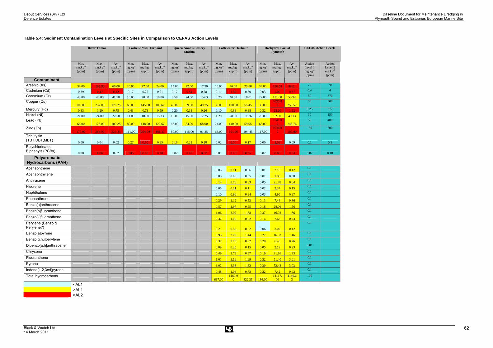
Debut Services (SW) Ltd Defence Estates
Baseline Document for Maintenance Dredging in Plymouth Sound and Estuaries European Marine Site
Black & Veatch Ltd 14 March 2011
62
Table 5.4: Sediment Contamination Levels at Specific Sites in Comparison to CEFAS Action Levels
River Tamar Carbeile Mill, Torpoint Queen Anne’s Battery Marina
Cattewater Harbour Dockyard, Port of Plymouth
CEFAS Action Levels
Min. mg.kg-1 (ppm)
Max. mg.kg-1 (ppm)
Av. mg.kg-1 (ppm)
Min. mg.kg-1 (ppm)
Max. mg.kg-1 (ppm)
Av. mg.kg-1 (ppm)
Min. mg.kg-1 (ppm)
Max. mg.kg-1 (ppm)
Av. mg.kg-1 (ppm)
Min. mg.kg-1 (ppm)
Max. mg.kg-1 (ppm)
Av. mg.kg-1 (ppm)
Min. mg.kg-1 (ppm)
Max. mg.kg-1 (ppm)
Av. mg.kg-1 (ppm)
Action Level 1 mg.kg-1 (ppm)
Action Level 2 mg.kg-1 (ppm)
Contaminant.
Arsenic (As) 39.00 102.00 69.00 20.00 27.00 24.00 15.00 22.00 17.50 16.00 46.00 23.80 33.00 196.00 88.81 20 70
Cadmium (Cd) 0.39 0.47 0.42 0.17 0.27 0.21 0.17 0.54 0.28 0.11 1.30 0.39 0.03 2.00 0.57 0.4 4
Chromium (Cr) 40.00 44.00 41.50 15.00 20.00 18.00 8.50 24.00 15.63 3.70 40.00 18.01 22.00 111.00 53.94 50 370
Copper (Cu) 103.00 237.00 176.25 68.00 145.00 106.67 46.00 59.00 49.75 30.00 100.00 55.45 33.00
1030.00 256.57
30 300
Mercury (Hg) 0.33 1.20 0.75 0.43 0.73 0.59 0.20 0.33 0.26 0.10 0.88 0.38 0.32 22.20 1.62 0.25 1.5
Nickel (Ni) 21.00 24.00 22.50 11.00 18.00 15.33 10.00 15.00 12.25 1.20 28.00 11.26 20.00 92.00 49.13 30 150
Lead (Pb) 66.00 126.00 100.25 80.00 148.00 122.67 46.00 84.00 68.00 24.00 140.00 59.95 63.00
1541.00 248.76
50 400
Zinc (Zn) 177.00 264.00 221.25 111.00 254.00 181.33 80.00 115.00 91.25 63.00 164.00 104.45 117.00
1034.00 405.00
130 600
Tributyltin (TBT,DBT,MBT) 0.00 0.04 0.02 0.27 0.50 0.35 0.16 0.21 0.18 0.02 0.74 0.17 0.00 1.56 0.09 0.1 0.5 Polychlorinated Biphenyls (PCBs) 0.00 0.06 0.02 0.05 0.16 0.10 0.02 0.02 0.02 0.01 0.19 0.05 0.02 0.05 0.04 0.02 0.18
Polyaromatic Hydrocarbons (PAH)
Acenaphthene 0.03 0.11 0.06 0.01 2.15 0.12 0.1
Acenaphthylene 0.03 0.08 0.05 0.01 1.98 0.08 0.1
Anthracene 0.14 0.70 0.33 0.05 21.78 0.84 0.1
Fluorene 0.05 0.21 0.11 0.02 2.37 0.15 0.1
Naphthalene 0.10 0.90 0.34 0.03 4.95 0.37 0.1
Phenanthrene 0.29 1.12 0.53 0.13 7.46 0.86 0.1
Benzo[a]anthracene 0.57 1.97 0.95 0.18 28.06 1.56 0.1
Benzo[b]fluoranthene 1.06 3.02 1.68 0.37 16.02 1.86 0.1
Benzo[k]fluoranthene 0.37 1.06 0.62 0.14 7.63 0.73 0.1
Perylene (Benzo g Perylene?) 0.21 0.56 0.32 0.06 3.02 0.42
0.1
Benzo[a]pyrene 0.93 2.79 1.44 0.27 16.53 1.46 0.1
Benzo[g,h,i]perylene 0.32 0.76 0.52 0.20 6.40 0.76 0.1
Dibenzo[a,h]anthracene 0.09 0.25 0.15 0.05 2.19 0.23 0.01
Chrysene 0.49 1.73 0.87 0.19 21.16 1.23 0.1
Fluoranthene 1.01 3.56 1.69 0.32 51.40 3.01 0.1
Pyrene 1.02 3.33 1.62 0.30 52.43 3.03 0.1
Indeno(1,2,3cd)pyrene 0.48 1.08 0.73 0.22 7.42 0.92 0.1
Total hydrocarbons 617.00
1180.00 822.33 186.00
14117.00
1140.63
100
<AL1 >AL1 >AL2
Debut Services (SW) Ltd Defence Estates
Baseline Document for Maintenance Dredging in Plymouth Sound and Estuaries European Marine Site
Black & Veatch Ltd 14 March 2011
63
This page has been left intentionally blank

Debut Services (SW) Ltd Defence Estates
Baseline Document for Maintenance Dredging in Plymouth Sound and Estuaries European Marine Site
Black & Veatch Ltd 14 March 2011
64
Table 5.5: Sediment Contamination Levels at Specific Sites in Comparison to Canadian Interim Sediment Quality Guidelines (ISQG)
River Tamar Carbeile Mill, Torpoint Queen Anne's Battery Marina
Cattewater Harbour
Dockyard Port of Plymouth
ISQG/ TEL
PEL
Min. mg.kg-1 (ppm)
Max. mg.kg-1 (ppm)
Av. mg.kg-1 (ppm)
Min. mg.kg-1 (ppm)
Max. mg.kg-1 (ppm)
Av. mg.kg-1 (ppm)
Min. mg.kg-1 (ppm)
Max. mg.kg-1 (ppm)
Av. mg.kg-1 (ppm)
Min. mg.kg-1 (ppm)
Max. mg.kg-1 (ppm)
Av. mg.kg-1 (ppm)
Min. mg.kg-1 (ppm)
Max. mg.kg-1 (ppm)
Av. mg.kg-1 (ppm)
mg.kg-1 (ppm)
mg.kg-1 (ppm)
%<ISQG ISQG<%<PEL %>PEL Contaminant.
Arsenic (As) 39.00 102.00 69.00 20.00 27.00 24.00 15.00 22.00 17.50 16.00 46.00 23.80 33.00 196.00 88.81 7.24 41.6 3 13 47 Cadmium (Cd) 0.39 0.47 0.42 0.17 0.27 0.21 0.17 0.54 0.28 0.11 1.30 0.39 0.03 2.00 0.57 0.7 4.2 6 20 71 Chromium (Cr) 40.00 44.00 41.50 15.00 20.00 18.00 8.50 24.00 15.63 3.70 40.00 18.01 22.00 111.00 53.94 52.3 160 4 15 53 Copper (Cu) 103.00 237.00 176.25 68.00 145.00 106.67 46.00 59.00 49.75 30.00 100.00 55.45 33.00 1030.00 256.57 18.7 108 9 22 56 Mercury (Hg) 0.33 1.20 0.75 0.43 0.73 0.59 0.20 0.33 0.26 0.10 0.88 0.38 0.32 22.20 1.62 0.13 0.7 8 24 37 Nickel (Ni) No ISQG No ISQG Lead (Pb) 66.00 126.00 100.25 80.00 148.00 122.67 46.00 84.00 68.00 24.00 140.00 59.95 63.00 1541.00 248.76 30.2 112 6 26 58 Zinc (Zn) 177.00 264.00 221.25 111.00 254.00 181.33 80.00 115.00 91.25 63.00 164.00 104.45 117.00 1034.00 405.00 124 271 4 27 65 Tributyltin (TBT,DBT,MBT)
Polychlorinated Biphenyls (PCBs) 0.00 0.06 0.02 0.05 0.16 0.10 0.02 0.02 0.02 0.01 0.19 0.05 0.02 0.05 0.04 0.0215 0.189 16 37 55
Polyaromatic Hydrocarbons (PAH)
Acenaphthene 0.03 0.11 0.06 0.01 2.15 0.12 0.00671 0.0889 8 29 57 Acenaphthylene 0.03 0.08 0.05 0.01 1.98 0.08 0.00587 0.128 7 14 51 Anthracene 0.14 0.70 0.33 0.05 21.78 0.84 0.0469 0.245 9 20 75 Fluorene 0.05 0.21 0.11 0.02 2.37 0.15 0.0212 0.144 Naphthalene 0.10 0.90 0.34 0.03 4.95 0.37 0.0346 0.391 Phenanthrene 0.29 1.12 0.53 0.13 7.46 0.86 0.0867 0.544 Benzo[a]anthracene 0.57 1.97 0.95 0.18 28.06 1.56 0.0748 0.693 9 16 78 Benzo[b]fluoranthene Benzo[k]fluoranthene Perylene
Benzo[a]pyrene 0.93 2.79 1.44 0.27 16.53 1.46 0.0888 0.763 8 22 71 Benzo[g,h,i]perylene 6 7 8 Dibenzo[a,h]anthracene 0.09 0.25 0.15 0.05 2.19 0.23 0.00622 0.135 16 12 65 Chrysene 0.49 1.73 0.87 0.19 21.16 1.23 0.108 0.846 9 19 72 Fluoranthene 1.01 3.56 1.69 0.32 51.40 3.01 0.113 1.494 10 20 80
Pyrene 1.02 3.33 1.62 0.30 52.43 3.03 0.153 1.398 7 19 83 Indeno(1,2,3cd)pyrene Total hydrocarbons
Below TEL
Between TEL and PEL
Above PEL No Data

Debut Services (SW) Ltd Defence Estates
Baseline Document for Maintenance Dredging in Plymouth Sound and Estuaries European Marine Site
Black & Veatch Ltd 14 March 2011 65
Heavy Metals Concentrations of Arsenic (As) within sediment is strongly influenced by the metaliferous geology of the river catchments which drain into the site, particularly in respect to the Tamar, Tavy and Lynher (MBA, 2003). As a result, background As concentrations in the sediments of the Plymouth Sound and Estuaries are elevated. This is contributed to by the historic legacy of mining and processing in the river catchments. However, these concentrations are an order of magnitude lower than other historic mining areas, such as the Fal and Hayle in Cornwall (MBA, 2003).
There is a strong correlation between As and iron (Fe) concentrations within estuarine sediments in the Tamar. This is probably related to the chemical reaction which causes the flocculation of Fe out of solution when river water mixes with seawater. During this process other heavy metals, such as As is scavenged by the formation of particulate Fe oxyhydroxide. Movement of contaminants will thus be greatly influenced by the movement of the turbidity maxima (see Section 5.1.4). This is reflected by the seasonal trends and spatial variability of cadmium (Cd), copper (Cu), iron (Fe), manganese (Mn), lead (Pb) and zinc (Zn). Given the close linkage with sediment movement, contamination will be influenced by fluvial inputs of new material (highest in periods of high river flow) and seasonal fluctuations in tidal pumping and movement of sediment. Grain size will also have a significant influence on concentrations; due to chemical bonding with clay particles (see Section 5.1.11). In low river flow summer conditions, fine sediments with higher contaminant concentrations accumulate at the head of the estuary. In winter, with higher flow conditions, fine sediments and associated contamination occur in the mid estuary. These are then flushed to the head of the estuary when low flow conditions return, as a result of tidal pumping.
However, the enrichment by Pb and Hg of sediments to seaward, around the Hamoaze indicates that there are additional anthropogenic sources. These may include outfalls and waste disposal. Cd concentrations in the upper Plym may have also originated from industrial sources. In addition, there may be localised sources of Zn contamination linked to the use of sacrificial anodes on vessels and recreational craft (MBA, 2003).
There may also be an increase in concentration of heavy metals (As, Zn, Pb and Cu) with sediment depth in the upper Tamar/ St John’s Lake. This may reflect the decline from peak mining activity in the nineteenth century. However, they appear to have been maintained to the present day as a result of run-off and leaching (MBA, 2003).
Previous work related to heavy metals in biota is documented within MBA, 2003 (see bibliography).
River Tamar: Historical data concerning the Tamar indicates that monitored heavy metals (As, Cd, Cu, Pb, Hg, Ni and Zn) are all below AL1 (MBA, 2003). CEFAS data obtained in 1998 (Table 5.4) indicates that the minimum and maximum figures for Zn (177 to 221.25 ppm) are above AL2. Similarly, the maximum figures for As and Cd so far encountered in this area are above AL2, although in the case of Cd there appear to be areas of the Tamar with contamination below AL1. Cu, Hg and Pb levels within the Tamar are all between AL1 and AL2. Although Cd levels are high on the CEFAS system, comparison with the Canadian sediment quality guidelines indicate that levels are below the TEL, giving only a 4% likelihood of an adverse biological effect. The metals which give cause for concern are As, Cu and Hg. All have minimum concentrations between the TEL and PEL. Average concentrations are above PEL giving,

Debut Services (SW) Ltd Defence Estates
Baseline Document for Maintenance Dredging in Plymouth Sound and Estuaries European Marine Site
Black & Veatch Ltd 14 March 2011 66
respectively a 47, 56 and 37% likelihood of an adverse biological effect. The average concentrations of Pb and Zn encountered within Tamar sediments are between the TEL and PEL, giving a respective 26 and 27% likelihood of an adverse biological effect. It should be noted that parts of the Tamar have Pb concentrations that exceed the PEL.
River Tavy: No publicly available data has been identified for this area.
Lynher Estuary: No publicly available data has been identified for this area.
Hamoaze: CEFAS data is available for the Dockyard area for 2004, 2006 and 2007. The maximum identified values for As, Cd, Cu, Hg, Pb and Zn are above AL2. However, in the case of As, Cu, Hg and Pb there appear to be areas where contamination is between AL1 and 2. In the case of Cr and Ni, maximum contamination levels are between AL1 and AL2, although there appear to be parts of the Dockyard with levels below AL1. This is also the case for Zn. The average sediment concentrations for As, Cu, Hg, Pb and Zn all exceed the PEL (see Table 5.5) Cd and Cr levels are below the TEL.
St John’s Lake: Contamination information exists for the north part of St John’s Lake around Carbeile Mill. The CEFAS database indicates samples were collected in 1999. These show that As, Cu, Hg and Pb levels are between AL1 and AL2. Cr and Ni are both below AL1. Average concentrations for As, Cu and Hg are between the PEL and TEL, although sites with Cu and Hg above the PEL can be encountered in this area. Pb average and maximum levels for the area exceed the PEL. Average Cr levels lie between the PEL and TEL. Average Cd levels are below the TEL.
Cattewater: Historically, sediment samples within the Plym, which outfalls into Cattewater have been below AL1 for As, Cd, Hg and Zn (MBA, 2003). Two areas of the Cattewater have been sampled according to the CEFAS database. These are Queen Anne’s Battery Marina and Cattewater Harbour. There is ambiguity in the location of the second set of results as the harbour is identified as being in the Tamar, were as Cattewater is the outfall of the Plym. Results for Queen Anne’s Battery Marina indicate that maximum figures for Cd are encountered above AL2, this is also the case for Cattewater Harbour. However, there are also parts of these two areas where Cd will be below AL1. Cu is consistently between AL1 and AL2 across both areas. Hg and Pb show maximum and average contamination readings across both areas which are between AL1 and AL2, although there are sites where contamination is below AL1. Cr and Ni are both below AL1 for both areas. The only difference between these two parts of Cattewater is that contamination by Zn has been shown to be above AL2 at some sampling points. However both areas also display sites where ZN is below AL1. At Queen Anne’s Battery Marina, As, Cu, Hg and Pb levels are between the PEL and TEL, see Table 5.4. Cd, Cr and Zn levels lie below the TEL. Within Cattewater Harbour average contamination levels of As, Cu, Hg and Pb are between the TEL and PEL, although As, Hg, and Pb exceeds the PEL at locations within the area. Average concentrations of Zn, Cu and Cr are below the TEL, albeit with localised variations for Zn and Cd which lie between the TEL and PEL.
Plymouth Sound (North of Breakwater): No publicly available data has been identified for this area.
Plymouth Sound (South of Breakwater): No publicly available data has been identified for this area.

Debut Services (SW) Ltd Defence Estates
Baseline Document for Maintenance Dredging in Plymouth Sound and Estuaries European Marine Site
Black & Veatch Ltd 14 March 2011 67
Tribuyltin (TBT) Previous work indicates that a combination of legislation to ban the use of TBT antifouling paint on recreational craft under 25 metres, together with containment procedures within the naval dockyard have reduced inputs to the Tamar estuary (MBA, 2003). TBT appears to behave seasonally in a similar manner to metals (see above). However, it should be noted that changes in pH, temperature, salinity, suspended solids, etc dictate deposition and remobilisation from sediments with historic contamination.
Potential sources of TBT within or adjacent to the site are thought to include: Devonport Dockyard, Millbay docks, Cattedown Wharves and numerous marina facilities around the Plymouth Sound and Estuaries site. Although sources can include fresh applications, it should be noted that where non-TBT replacement coatings are being used, TBT will need to be removed as part of vessel maintenance when old coatings are stripped. The dockyard has instigated a system of collection and removal to a waste site Chelson Meadow (MBA, 2003). Given the long term decline in TBT use and removal by maintenance the issue of new releases will have declined since the late 1980’s. However, reworking of sediments can lead to the release of TBT and derivatives (DBT).
Previous work related to TBT in biota is documented within MBA, 2003, see bibliography.
River Tamar: 1998 CEFAS data indicates that TBT levels on the Tamar are below AL1. This is in keeping with previous historic information (MBA, 2003).
River Tavy: No publicly available data has been identified for this area.
Lynher Estuary: No publicly available data has been identified for this area.
Hamoaze: CEFAS data for the Dockyard area (obtained in 2004, 2006 and 2007) indicates that minimum and average TBT contamination levels across the dockyard area can be below AL1. However, there are sites within the dockyard which exceed AL2.
St John’s Lake: Maximum levels of TBT show that sites within the Carbeile Mill area are above AL2, although minimum and average figures show variation with sites being between AL1 and AL2.
Cattewater: CEFAS data for Queen Anne’s Battery Marina and Cattewater Harbour (undated) indicates average levels of TBT contamination are between AL1 and AL2. However, there are areas of the Cattewater Harbour where TBT levels are below AL1. This is not the case for Queen Anne’s Battery Marina where levels are consistently between AL1 and AL2.
Plymouth Sound (North): No publicly available data has been identified for this area. Plymouth Sound (South): No publicly available data has been identified for this area.
Polychlorinated Biphenyls (PCBs) River Tamar: On average, PCB figures in the Tamar are below AL1, although
sites with PCB levels above AL2 have been detected. Comparison with Canadian sediment quality guidelines show that levels are on average below the TEL, with some sites showing levels between the TEL and PEL.
River Tavy: No publicly available data has been identified for this area.
Lynher Estuary: No publicly available data has been identified for this area.
Debut Services (SW) Ltd Defence Estates
Baseline Document for Maintenance Dredging in Plymouth Sound and Estuaries European Marine Site
Black & Veatch Ltd 14 March 2011 68
Hamoaze: CEFAS data for the Dockyard area (obtained for 2004, 2006 and 2007) indicates maximum figures and average levels of PCB contamination are above AL2. However, there appear to be areas of the Dockyard where PCB levels are below AL1. The Canadian sediment quality guidelines indicate maximum and average levels lie between the TEL and PEL, indicating a 27% likelihood of an adverse biological reaction to marine life associated with these sediments.
St John’s Lake: Minimum, maximum and average levels for PCB contamination from samples taken in 1999 is consistently above AL2. However, the levels are between the TEL and PEL giving a 37% likelihood of an adverse biological effect to marine life.
Cattewater: CEFAS data for Queen Anne’s Battery Marina and Cattewater Harbour (undated) indicates maximum and average levels of PCB contamination are above AL2. However, there are areas of the Cattewater where PCB levels are below AL1. Under the Canadian sediment quality guidelines, Queen Anne’s Battery has average sediment quality concentrations of PCBs below the TEL, whilst those for Cattedown harbour are between the TEL and PEL.
Plymouth Sound (North): No publicly available data has been identified for this area.
Plymouth Sound (South): No publicly available data has been identified for this area.
Polycyclic Aromatic Hydrocarbons & Total Hydrocarbons Previous studies indicate that there is a toxic threat to the estuary derived from polycyclic aromatic hydrocarbons (PAH). There is evidence to suggest that decline in mussel health in areas of the estuary (Beggars’ Island) could be linked to PAH contamination of sediments (PMA, 2004). Previous work related to PAH in biota is documented within a report by MBA (2003).
Review of the CEFAS database show that PAH data only exists for Cattewater Harbour and the Dockyard. The majority of samples are all above AL1 (there is no AL2 for PAHs). In general, readings for Cattewater are lower than the Dockyard. Analysis of the figures indicates that the dockyard area has significantly high contamination both in PAHs and Total Hydrocarbons. For example AL1 for Total Hydrocarbons is 100ppm. The average in the Dockyard area over 2004, 2006 and 2007 is 1140.6ppm, with the highest recorded reading being 14,117 ppm. Under the Canadian sediment quality guidelines, PAH figures are either between the TEL and PEL or exceed the PEL.
Conclusion The CEFAS data indicates that the sediments of the area have been contaminated by both current and historic sources. However, given the limited geographical coverage, the data cannot be used to reflect the contamination levels of the whole of the Plymouth Sound and Estuaries European Marine Site. It should also be noted that within relatively small areas (e.g. dock basins and embayments) there can be variation in contamination levels.

Debut Services (SW) Ltd Defence Estates
Baseline Document for Maintenance Dredging in Plymouth Sound and Estuaries European Marine Site
Black & Veatch Ltd 14 March 2011 69
5.5 Water Quality
The following section describes the water quality of the study area. Water quality is important for benthic infauna and hence the feeding resource for waterfowl can be impacted as a consequence of poor water quality.
The Environment Agency makes periodic assessments of the quality of rivers across England and Wales in order to report trends over time and satisfy legislative requirements. Data is then compared against environmental quality standards (EQS), which are designed to protect the environment and human health. Within the study area, there are a number of applicable EC Directives which trigger a requirement for monitoring which are described below.
• EC Water Framework Directive (WFD) (2000/60/EC) - this is the driver for water quality monitoring which is required to establish a framework for the protection of inland surface waters, transitional waters, coastal waters and groundwater. The WFD outlines that all aquatic ecosystems should meet ‘good status’ by 2015.
• EC Bathing Water Directives (76/160/EEC and 2006/7/EC) - sets stringent water quality standards in order to preserve, protect and improve the quality of the environment and to protect human health.
• EC Shellfish Waters Directive (2006/113/EEC) - this sets standards in terms of faecal coliforms in shellfish waters and flesh which allows for the classification of harvesting areas.
• EC Urban Waste Water Treatment Directive (91/271/EEC) - the objective is to protect the environment from the adverse effects of sewage discharges. It sets treatment levels on the basis of sizes of sewage discharges and the sensitivity of waters receiving the discharges.
• EC Dangerous Substances Directive (67/548/EEC) - this Directive controls the levels of dangerous substances going into inland, coastal and territorial waters. Dangerous substances are toxic substances that pose the greatest threat to the environment and human health.
• EC Nitrates Directive (91/676/EEC) - sets a threshold of 50mgl-1 for the identification of vulnerable waters in order to protect all waters against pollution by nitrates from agricultural sources.
5.5.1 Estuarine Water Quality
As part of the WFD River Basin Management Plans (RBMPs) have been drafted which set out the environmental objectives for all the water bodies within the River Basin District and how they will be achieved. Plymouth Sound falls into the South West RBMP.
Transitional water bodies (estuaries) in the UK have been classified in terms of whether they are likely to meet the requirements of the WFD to reach good status by 2015. The Environment Agency has classified Plymouth Sound as having good ecological potential (this is equivalent to good ecological status for estuaries such as Plymouth Sound which have been classified as being heavily modified water bodies due to substantial changes to its physical character resulting from physical alterations caused by human use). Predicted ecological quality for 2015 is also good. However Plymouth Sound does not meets the acceptable standards for chemistry and is classed as failing the requirements of the WFD for chemical water quality. This is not predicted to change by 2015. Overall Plymouth Sound is at risk of failing to meet the requirements of the WFD.

Debut Services (SW) Ltd Defence Estates
Baseline Document for Maintenance Dredging in Plymouth Sound and Estuaries European Marine Site
Black & Veatch Ltd 14 March 2011 70
The Tamar Estuaries Consultative Forum (TECF) list ‘pollution due to dredging’ (specifically disturbance of contaminated sediments) as a potential challenge to achieving good water quality (TECF, 2006) The requirements for action to combat this challenge are as follows:
• to produce and implement dredging protocols • to quantify threat caused by resuspension of contaminated
sediments due to (a) dredging (b) trampling of intertidal mudflat • to develop a plan for minimising impacts of (a) &(b).
5.5.2 Bathing Water Quality
There are 6 designated bathing waters located within Plymouth Sound. These points, shown on Figure 5-1reflect the Environment Agency’s monitoring points and are monitored and classified for water quality yearly.
Bathing water quality is assessed by standards listed in the EC Bathing Waters Directive. The Directive was adopted by the Council of the European Communities in 1975 and transposed into law for England and Wales to form the Bathing Waters (Classification) Regulations 1991. The Directive is concerned with the quality of bathing water for the purpose of protecting public health and requires monitoring of microbiological parameters and a small number of physical parameters e.g. visible oil.
There are two types of microbiological standards set out in the Directive, namely the mandatory standards and the more stringent guideline standards.
The imperative standards, which should not be exceeded are:
10,000 total coliforms per 100ml of water; and 2,000 faecal coliforms per 100ml of water
For bathing water to comply with the Directive, 95% of samples collected within a bathing season (15th May to 30th September) must meet these and the other physical criteria.
The guideline standards which should be achieved where possible are:
• No more than 500 total coliforms per 100ml of water • No more than 100 faecal coliforms per 100ml of water (in at least 80% of
samples) • No more than 100 faecal streptococci per 100ml of water (in at least 90%
of samples).
Water quality is classified by the Environment Agency as ‘excellent’, ‘good’ or ‘poor’. ‘Excellent’ relates to the achievement of the more stringent Directive standards and ‘good’ relates to the achievement of the mandatory standards. Bathing waters classified as ‘poor’, fail to meet the Directive’s minimum mandatory standard.

Debut Services (SW) Ltd Defence Estates
Baseline Document for Maintenance Dredging in Plymouth Sound and Estuaries European Marine Site
Black & Veatch Ltd 14 March 2011
71
Figure 5-1: The Environment Agency’s water quality monitoring points and designated shellfish waters

Debut Services (SW) Ltd Defence Estates
Baseline Document for Maintenance Dredging in Plymouth Sound and Estuaries European Marine Site
Black & Veatch Ltd 14 March 2011 72
A summary of the most recent sample data for the locations in Plymouth Sound is shown in Table 5.6: Bathing water quality at designated bathing beaches within the Plymouth Sound and Estuaries SAC (Environment Agency, 2009).. Water quality is yet to be classified for the year 2009.
Table 5.6: Bathing water quality at designated bathing beaches within the Plymouth Sound and Estuaries SAC (Environment Agency, 2009).
Year Location
2004 2005 2006 2007 2008
Wembury Excellent Excellent Excellent Excellent Good
Bovisand Excellent Excellent Good Excellent Good
Plymouth Hoe (E) Excellent Excellent Excellent Excellent Poor
Plymouth Hoe (W) Excellent Excellent Excellent Excellent Poor
Kingsand Excellent Excellent Excellent Excellent Good
Cawsand Excellent Excellent Excellent Excellent Excellent
Generally water quality has been excellent; indicating that water quality has met the stricter guideline standards set by the EC Bathing Water Directive. In 2008 there was a decline in water quality with Plymouth Hoe East and West failing to meet the guideline standards, despite recent improvements to STWs in this area. It is thought that summer rainfall may have contributed to the reduction in water quality (Marinet, 2009).
The marine environment is relatively hostile to microbial pathogens and the majority rapidly die upon entering the estuary. However, some can become associated with sediment particles which will prolong survival to days or weeks. This should be taken into consideration when dredging in close proximity to bathing waters or shellfish waters during bathing or harvesting season (MBA, 2003).
A revised Directive has been proposed which will simplify and consolidate the existing Directive and take account of technical progress and new knowledge. Based on epidemiological research and experience from the implementation of the current Directive, the revised version aims to modernise the management of bathing waters.
The proposal was adopted by the European Commission on 24 October 2002. It makes use of only two bacteriological indicator parameters, but sets a higher health standard than the 1976/160 Directive targeting health standards relating to faecal pollution (the primary cause of concern).
The classification of a beach's water quality will be determined on the basis of a three-year trend rather than one year's results and so will be less susceptible to bad weather conditions or "one-off" incidents. It will also allow beaches with exceptionally good water quality to exploit/capitalise on the situation.
The new Bathing Water Directive became law in the UK in March 2008 and will take effect by 2015.

Debut Services (SW) Ltd Defence Estates
Baseline Document for Maintenance Dredging in Plymouth Sound and Estuaries European Marine Site
Black & Veatch Ltd 14 March 2011 73
5.5.3 Shellfish Water Quality
The Shellfish Waters Directive (see Section 5.4) aims to protect the aquatic habitat of the bivalve and gastropod molluscan species of shellfish. Species covered include oysters, mussels, cockles, scallops and clams but not shellfish crustaceans such as crabs, crayfish and lobsters. The Shellfish Waters Directive is implemented in the UK under the Shellfish Waters (Shellfish) (Classifications) Regulations 1997.
Shellfish waters are monitored for various parameters based on water quality standards established by the Directive. These parameters include suspended solids, salinity, dissolved oxygen (DO), organo-halogenated substances (e.g. PCBs, organochlorine pesticides), metals and guideline values for coliforms in shellfish flesh. For each substance, the Directive specifies the minimum number of samples to be taken, the water quality standards to be met and the percentage of samples that must meet these standards. The standards are either a numeric limit or a descriptive standard. The water quality standards have been met if the following percentage of the samples analysed do not exceed the limit values:
• 100% for metals and organo-halogen compounds • 95% for salinity and Dissolved Oxygen (DO) • 75% for other substances • No evidence of harm to the shellfish from organo-halogenated compounds.
There are currently three designated shellfish waters located within the study area (Figure 5-1) which cover the Tamar, Lynher and Yealm estuaries. Designated shellfish waters are currently under review by Defra, who have a commitment to improving water quality to a level where all designated shellfish waters can support at least a ‘class B’ production area. The UK is committed to maintaining a broad match between designated shellfish waters and shellfish harvesting areas and Defra has pledged to keep the number of designations in England under review.
The majority of shellfish beds within the Plymouth Sound and Estuaries European Marine Site were classified as category B with the exception of the Tamar and the Plym where production was prohibited (data from 2001). As a result of the Defra review, the Tamar designated shellfish water is proposed for de-designation.
5.5.4 Summary of Toxic Contaminants
Metals
Results from the National Monitoring Programme surveys conducted between 1992 and 1995 revealed no evidence that Environmental Quality Standards (EQS) for Cadmium (Cd), Copper (Cu), Nickel (Ni), Lead (Pb), and Zinc (Zn) were exceeded in the Plymouth Sound and Estuaries European Marine Site. It was noted, however, that there was an increase in concentrations from offshore, through intermediate, to inshore sites. This is due to the proximity to inputs as well as natural processes and can give rise to potential water quality issues at estuarine sites, particularly in low salinity regions (MBA, 2003).
Organotins
The EQS for Tributyltin (TBT) is often exceeded, particularly in the estuarine parts of the Plymouth Sound and Estuaries European Marine Site. On analysis of Environment Agency data, the MBA (2003) indicated that little TBT enters the

Debut Services (SW) Ltd Defence Estates
Baseline Document for Maintenance Dredging in Plymouth Sound and Estuaries European Marine Site
Black & Veatch Ltd 14 March 2011 74
system from freshwater i.e. the Tamar, Tavy and Lynher were all found to have annual concentrations at the limit of detection. There was found to be a downward trend in the reported Tamar data at Gunnislake, the Tavy at Denham Bridge and the Lynher at Notter Bridge. No freshwater data was available for the Plym or Yealm at the time.
Most of the Environment Agency data for Triphenyltin (TPT) analysed by the MBA (2003) was found to be below detection limits. Based on limited evidence from the sampling, it was thought some TPT in sewage and trade discharges represents a possible source to the area and may be reflected in estuarine water samples close to discharges.
Pesticides and Herbicides
The most recent Environment Agency data for pesticides and herbicides analysed by the MBA in 2003 was for tidal waters in Plymouth Sound and Estuaries European Marine Site between 1990 and 1997. There were few results in the Environment Agency database for total hexachlorocyclohexanes (HCH), the majority of results at this time being for gamma-HCH used in insecticides. For freshwater and tidal waters, detection limits used are generally well below the EQS.
PCB’s
The data available in 2003 on PCBs in waters and sediment was not accurate enough to assess site characteristics or spatial trends (MBA, 2003).
Hydrocarbons (Oil, PAH’s)
There are no reports available for review concerning oil impact in Plymouth Sound and Estuaries. However a few sites have been described as containing unspecified ‘hydrocarbon oils’. The concentrations were generally low with the exception of the Hamoaze, a shellfishery near Jupiter Point in the mouth of the Lynher and the River Tavy at Lopwell Dam.
In the absence of recent data for concentrations in water and discharges, or the nature of the hydrocarbons, the current water quality status regarding hydrocarbons cannot be fairly commented on.
PAHs
The highest concentrations of PAHs occur in major estuaries and generally reflect inputs from a wide range of combustion processes involving industrial sources. Although there is a limited amount of information in the EA dataset for PAH concentrations in waters of the Plymouth Sound and Estuaries European Marine Site (MBA, 2003).
5.5.5 Summary of Non-Toxic Contaminants
Nutrient Quality
There are no statutory water quality standards for nutrients in the UK and therefore monitoring of nutrient levels is generally a subjective assessment. Various methods have been used to compare estuaries. One method employed by Cole et al. (1999) compares the nutrient status of estuaries in the UK using the total inorganic nitrogen (TIN) and total reactive phosphate (TRP –phosphate in unfiltered samples). Using these criteria the projected classification for TIN was found to be above average for the Tamar, Lynher and Yealm. The projected TRP for the Yealm was found to be almost double the average value however TRO for the Tamar and Lynher were very low.
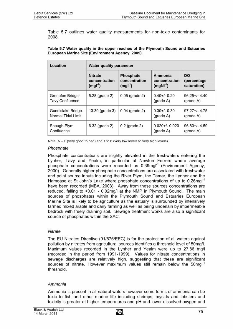
Debut Services (SW) Ltd Defence Estates
Baseline Document for Maintenance Dredging in Plymouth Sound and Estuaries European Marine Site
Black & Veatch Ltd 14 March 2011 75
Table 5.7 outlines water quality measurements for non-toxic contaminants for 2008.
Table 5.7 Water quality in the upper reaches of the Plymouth Sound and Estuaries European Marine Site (Environment Agency, 2009).
Water quality parameter Location
Nitrate concentration (mgl-1)
Phosphate concentration (mgl-1)
Ammonia concentration (mgNl-1)
DO (percentage saturation)
Grenofen Bridge-Tavy Confluence
5.28 (grade 2) 0.05 (grade 2) 0.40+/- 0.20 (grade A)
96.25+/- 4.40 (grade A)
Gunnislake Bridge-Normal Tidal Limit
13.30 (grade 3) 0.04 (grade 2) 0.30+/- 0.30 (grade A)
97.27+/- 4.75 (grade A)
Shaugh-Plym Confluence
6.32 (grade 2) 0.2 (grade 2) 0.020+/- 0.020 (grade A)
96.80+/- 4.59 (grade A)
Note: A – F (very good to bad) and 1 to 6 (very low levels to very high levels).
Phosphate
Phosphate concentrations are slightly elevated in the freshwaters entering the Lynher, Tavy and Yealm, in particular at Newton Ferrers where average phosphate concentrations were recorded as 0.39mgl-1 (Environment Agency, 2000). Generally higher phosphate concentrations are associated with freshwater and point source inputs including the River Plym, the Tamar, the Lynher and the Hamoase at St John’s Lake where phosphate concentrations of up to 0.26mgl-1 have been recorded (MBA, 2003). Away from these sources concentrations are reduced, falling to <0.01 - 0.02mg/l at the NMP in Plymouth Sound. The main sources of phosphates within the Plymouth Sound and Estuaries European Marine Site is likely to be agriculture as the estuary is surrounded by intensively farmed mixed arable and dairy farming as well as being underlain by impermeable bedrock with freely draining soil. Sewage treatment works are also a significant source of phosphates within the SAC.
Nitrate
The EU Nitrates Directive (91/676/EEC) is for the protection of all waters against pollution by nitrates from agricultural sources identifies a threshold level of 50mg/l. Maximum values recorded in the Lynher and Yealm were up to 27.86 mg/l (recorded in the period from 1991-1999). Values for nitrate concentrations in sewage discharges are relatively high, suggesting that these are significant sources of nitrate. However maximum values still remain below the 50mgl-1
threshold.
Ammonia
Ammonia is present in all natural waters however some forms of ammonia can be toxic to fish and other marine life including shrimps, mysids and lobsters and toxicity is greater at higher temperatures and pH and lower dissolved oxygen and

Debut Services (SW) Ltd Defence Estates
Baseline Document for Maintenance Dredging in Plymouth Sound and Estuaries European Marine Site
Black & Veatch Ltd 14 March 2011 76
salinity. Anthropogenic sources within Plymouth Sound and Estuaries SAC include sewage treatment effluent and run-of from agricultural land. Previous data show annual medium concentrations below 0.1mgl-1 with the highest values being recorded at sampling points in close proximity to STWs including in the Yealm downstream of the STW and in the Lynher at Polbathic, the Tavy near Bere Ferrers and the Plym at Saltram House. It is unlikely that the 21μgl-1 EQS for NH3 (N) is exceeded although the need for further monitoring has been noted.
Dissolved oxygen
Dissolved oxygen (DO) is measured either as a concentration (mgl-1) or as a percentage saturation (%). DO levels vary with temperature and the lowest levels will occur within the estuary during summer months. DO will fluctuate with photosynthetic activity and is related growth of macroalgae and phytoplankton (known as algal blooms) which in turn are determined by levels of nutrients which stimulate growth. During the day photosynthetic activity may result in supersaturation of oxygen and at night levels may drop due to respiration. EQS values for saline waters vary depending on the use, with a value of 8mgl-1 being suggested as GQA class A or B by Nixon et al. (1995).
The areas of Plymouth Sound and Estuaries SAC that are particularly vulnerable to problems are semi-enclosed bodies of water with long retention times where stratification of the water column occurs (MBA, 2003). In particular the upper Tamar estuary, the Lynher and the Yealm are sensitive to low DO levels which are the same areas where nutrient concentrations are relatively high (MBA, 2003). With the estuary DO is, as expected, lowest during the summer months. Other areas of reduced DO include adjacent to the shellfishery in the Yealm and the Tamar Estuary (off Pentile castle and Tamar Bridge). Depletion is thought to occur in tidal waters, rather than in the freshwaters which enter the estuary with possible causes being organic enrichment, BOD, suspended solids and stratification of the water column (MBA, 2003).
Chlorophyll a
Chlorophyll a is a useful measure of nutrient inputs into estuarine waters. Blooms of phytoplankton will result in elevated chlorophyll a levels and are expected to rise in spring due to the natural spring bloom.
Sites monitored in the Plym and Yealm recorded generally low chlorophyll a levels whilst sites in the Tamar and Lynher showed highest concentrations in the uppermost reaches of the estuary where mean annual values of 120μgl-1 and individual sample values of 396μgl-1 were recorded during summer months (MBA, 2003). Higher values may be indicative of algal blooms. However there is no information about species contributing to these blooms and whether this could have further impacts for the estuarine ecosystem (e.g. is they are toxic species).
Waters in the lower estuary at Hamoaze and the Sound generally do not show mean annual concentrations above 10μgl-1 with maximum values up to 80μgl-1 (MBA, 2003). Freshwaters entering the estuary have low chlorophyll a concentrations.
Debut Services (SW) Ltd Defence Estates
Baseline Document for Maintenance Dredging in Plymouth Sound and Estuaries European Marine Site
Black & Veatch Ltd 14 March 2011 77
Turbidity
Turbidity is caused by scattering and absorption of light particles as they enter the water column, and as such is affected by a number of parameters including inorganic and organic particulate suspended matter which is influenced by the presence of algal blooms. In order to quantify turbidity in Plymouth Sound and Estuaries SAC the Environment Agency measure both suspended solids (measured in mgl-1) and light scattering (measured using a turbidimeter calibrated with Formazin).
Light scattering mean annual values within the SAC range from 0.7 – 814 FTU (Formazin Turbidity Units) and are generally higher in the upper reaches of the estuary which may be the result of silt deposits as well as suspended solids in discharges, chemical flocculation and plankton (MBA, 2003). In the majority of lower tidal waters, mean annual turbidity is below 20 with individual values rarely exceeding 50 FTU (MBA, 2003).
Suspended solids within the SAC range from 0.2 – 570mgl-1 (measured 1990-2002) with the majority of samples having relatively low concentrations. The main sources of suspended solids in Plymouth Sound and Estuaries SAC are discharges, primarily from STWs. In 2001 the highest concentrations were from St. Levans (mean and max 488 and 1360mgl-1) and Marlborough St (mean and max 660 and 2430mgl-1). Other sources of suspended sediment in the estuary are dredging, freshwater inputs and urban and agricultural run-off (MBA, 2003).
Increased turbidity can lead to a reduction in availability of light which can lead to reduced algal growth rates and subsequent impacts on zooplankton, benthic fauna and fish.
5.6 Ornithology
Tamar Estuaries Complex SPA was designated in June 1997 and updated in February 2002. It qualifies as a SPA under Article 4.1 for supporting 18.5% of the British population of Avocet Recurvirostra avosetta over winter and at least 9.3% of the British population of migrating Little Egret Egretta garzetta. The national and international thresholds for bird species within the Tamar Estuaries Complex SPA and counts for these species are given in Table 5.8.
The extensive intertidal mudflats of the estuary system have diverse infaunal communities rich in bivalves and other invertebrates which provide feeding grounds for waterbirds in numbers of international importance.
Other species for which the Tamar Estuaries Complex SPA supports numbers greater than the 1% national threshold (or species with very low national populations) include Ardea cinerea (Grey Heron), Tringa erythropus (Spotted Redshank), Tringa nebularia (Greenshank) and Larus melanocephalus (Mediterranean Gull).

Debut Services (SW) Ltd Defence Estates
Baseline Document for Maintenance Dredging in Plymouth Sound and Estuaries European Marine Site
Black & Veatch Ltd 14 March 2011 78
Table 5.8 WeBS High Tide Counts, 2002/3 – 2006/7 for Tamar Estuary Complex (Austin et al., 2008).
1% thresholds for national and international importance Species Great Britain International
Tamar Estuary Complex (5 year mean peak 2002/3 – 2006/7)
Little Egret Egretta garzetta - 1300 124
Avocet Recurvirostra avosetta 35 730 422
Grey Heron Ardea cinerea - 2700 54 Spotted Redshank Tringa erythropus - 900 11
Greenshank Tringa nebularia 6 2300 40
Mediterranean Gull Larus melanocephalus - 6600 26
Note: ‘-’ denotes no threshold given.
Avocet Recurvirostra avosetta
The Avocet is an Annex 1 waterfowl species for which the Tamar Estuaries Complex SPA is designated. Numbers of Avocet at this site have increased over the last five years from 317 in 2002/3 to 465 in 2006/7 with counts being especially high in January (Austin et al., 2008). This species is found in the upper reaches of the Tamar Estuary where it is known to feed on insects, crustaceans and occasionally small fish. No WeBS alerts have been triggered for this species.
Little Egret Egretta garzetta
The Little Egret is an Annex 1 waterfowl species for which the Tamar Estuaries Complex SPA is designated as it supports more than 1% of the national population in the non-breeding season. Whilst overall numbers of Little Egret in Britain have increased, numbers in the Tamar Estuary Complex have remained relatively steady at around 120 to 143, with a small decline in 2006/7 to 97 (Austin et al., 2008). Little Egret favour muddy creeks and river channels and are known to roost in saltmarsh. No WeBS alerts have been triggered for this species.
In addition to supporting these two Annex 1 species, the Tamar Estuary Complex is of national importance for its wintering populations of around 6,000 wildfowl and 10,000 waders.
The upper estuary regularly supports Black-tailed Godwit in winter in numbers up to 150, 3–4% of the British wintering population. Other waders which feed on the productive mud flats particularly in the west of the complex include up to 5,000 Dunlin, 800 Curlew, 500 Oystercatchers and 200 Redshank. There is also a large gull roost of up to 4,000 Black-headed Gulls.
In addition the upper reaches of the Tamar Estuary support Numenius phaeopus (Whimbrel). Greenshank, Spotted Redshank and T. ochropus (Green Sandpiper) all uncommon wintering species in Britain, together with large numbers of Pluvialis apricaria (Golden Plover) (an Annex I species).
Debut Services (SW) Ltd Defence Estates
Baseline Document for Maintenance Dredging in Plymouth Sound and Estuaries European Marine Site
Black & Veatch Ltd 14 March 2011 79
Further south, St John’s Lake west of Hamoaze, supports up to 5,000 widgeon. Also present in high numbers are Mute swan, Brent geese, shelduck and teal. There is also a large gull roost in this area which contains up to 14,000 black-headed gulls. Other species of importance include the Canada goose Branta Canadensis; Mallard which are present only in the upper reaches of the estuary and Shelduck which are found primarily in the southern Tamar (PMA, 2004). Analysis of 10 bird species in the Tamar estuary undertaken by PMA (2004) found that numbers were being ‘generally maintained’ with the exception of widgeon, which has declined since the 1980’s.
5.7 Noise (In respect of disturbance to birds)
Previous studies for developments in the Tamar have shown that there is little existing baseline information available for noise levels on the Estuary (B&V, 2005). However, it is likely that noise levels are relatively low within the Estuary, typical of rural locations. Existing sources of noise are likely to comprise vessel movements (naval, recreational and ferry routes), traffic movements (e.g. at the Tamar Bridge and close to urban areas) and industrial noise (e.g. near to naval dockyards and marinas).
Species for which the Tamar Estuaries Complex SPA is designated utilise this area for over-wintering as part of their migration route. The area is also of national importance for its wintering populations of around 6,000 wildfowl and 10,000 waders as described in Section 5.5. Birds use the extensive mudflats during low tides for feeding, whereas the dredging activities occur around high water during times when birds are not using this area.
Dredging activities in Plymouth Sound have been ongoing since at least the latter half of the 19th Century and therefore birds of the SPA are likely to already be accustomed to such background noise. Noise from dredging is likely to be lower than noise resulting from the operation of other regular shipping operations, such as ferry routes, recreational boating and naval operations.
5.8 New and Future Relevant Legislation
This section outlines new legislation which has been passed and other known future legislation which may have an impact on maintenance dredging activities within the Plymouth Sound and Estuaries European Marine Site.
The Marine and Coastal Access Act 2009-12-11
The Marine and Coastal Access Bill received royal assent on 12 November 2009. It covers a number of subjects including marine planning, migratory and freshwater fisheries, coastal access and coastal and estuary management. It also sets up a new Marine Management Organisation (MMO) as the body who will deliver many of the objectives of the Act. The application process for licences will change as it will no longer be necessary to apply separately for CPA and FEPA consent as the majority of consents in England and Wales will be dealt with by the MMO. The MMO has been established as of April 2010.
The Act also introduces Marine Conservation Zones (MCZs) which will protect nationally important marine wildlife, habitats, geology and geomorphology. In the
Debut Services (SW) Ltd Defence Estates
Baseline Document for Maintenance Dredging in Plymouth Sound and Estuaries European Marine Site
Black & Veatch Ltd 14 March 2011 80
same way as other designations there will be restrictions on certain activities, with areas where some activities are allowed but not others, or some places where restrictions may be seasonal. Currently a group called ‘Finding Sanctuary’ are developing recommendations for MCZs in the south-west and will present their report in October 2011.
The Marine Strategy Framework Directive
This was formally adopted by all EU member states in June 2008 and will be transposed to UK law by July 2010. The Directive requires member states to prepare national strategies to manage their seas and achieve or maintain good environmental status by 2020. Good environmental status is defined by 11 high level descriptors. As yet it is not fully understood what impact, if any, this Directive will have on dredging activities within the Plymouth Sound and Estuaries European Marine Site.

Debut Services (SW) Ltd Defence Estates
Baseline Document for Maintenance Dredging in Plymouth Sound and Estuaries European Marine Site
Black & Veatch Ltd 14 March 2011 81
This page has been left intentionally blank

Debut Services (SW) Ltd Defence Estates
Baseline Document for Maintenance Dredging in Plymouth Sound and Estuaries European Marine Site
Black & Veatch Ltd 14 March 2011 82
6. CONCLUSIONS AND RECOMMENDATIONS
The Influence of Historic Dredging Activity on the Plymouth Sound and Estuaries European Marine Site
Previous studies have indicated that maintenance dredging and capital deepening of the main channel appear to have had no long term impact upon the intertidal extent of the estuary (PMA, 2004). This is based upon analysis of four discreet areas of the estuary:
• Cattewater (Fishers Nose to Laira Bridge) - From 1932 to 2003 the total intertidal area has decreased from 0.98 to 0.93 km² (5%). This is consistent with known reclamations. It may also be a reflection of dredging required for the marina development at Clovelly Bay rather than maintenance of the main channel, which appears unchanged up to 2003.
• Plymouth Sound (North of Breakwater excluding Cattewater, Hamoaze and Millbay Docks) - There appears to have been little change to the coast of Plymouth Sound in the last 100 years. The only known change within the area is the progressive deepening of the main navigation channel and anchorages for deep draught vessels.
• Hamoaze (Narrows to Albert Bridge, excluding Lynher Estuary) - The intertidal area of the Hamoaze has decreased by approximately 6% since 1895. This is principally attributable to the development of the No5 Basin and Weston Mill Jetties by 1932 and subsequent quay wall built by the 1990’s. Analysis of data indicates that the decrease in intertidal mud probably took place between 1895 and 1931, with no significant change since then (PMA, 2004). This would suggest that capital deepening and maintenance dredging alongside the berths in the Naval Dockyard has had a “negligible influence on the extent of the intertidal mud in the Hamoaze” (PMA, 2004). There may be some loss around the Trevor Channel at the north end of West Mud which was deepened in recent years.
• Tamar River (Albert Bridge to the confluence with the Tavy) - The area appears to have changed little in the last 100 years. There was a slight loss of 1.7% of the intertidal due to reclamation of Saltmill Creek. It should be noted that comparison of survey data for 1895 and 1933 indicates little change in the intertidal due to the 1901 dredging at Ernesettle (PMA, 2004). However, 1901 data indicates a loss of 12% of the intertidal, of which 9% is subsequently recovered by 1933. There has been a slight gain in material at the Ernesettle area in the last 100 years (i.e. after the 1901 dredging effort).
Based upon this work it is considered that changes to the cross-sectional area of the estuary due to historic modifications of the Dockyard and dredging between 1895 and 2001 appear to have had an insignificant impact upon the overall estuarine tidal dynamics.
Where evidence exists, there do not appear to have been any changes in the abundance of biota. This is with respect to the post 1985 peak in dredging activity at Weston Mill Lake.
The decline in catches of salmon and sea trout on the Tamar is thought to be linked to a large scale climatic change, rather than local human activity on the estuary (PMA, 2004). No bird species has shown any significant change numbers during the historic 1986 peak dredging activity, or the following winter. There is evidence of saltmarsh erosion at Egypt Marsh (12m loss between 1946 and 1999 (PMA, 2004).

Debut Services (SW) Ltd Defence Estates
Baseline Document for Maintenance Dredging in Plymouth Sound and Estuaries European Marine Site
Black & Veatch Ltd 14 March 2011 83
A previous study has recommended that potential negative effects should be considered when developing future dredging regimes, but that there are other, possibly more significant factors which may be affecting the estuary (PMA, 2004). These include sea level rise, reclamation of land, dock development, water abstraction, agriculture, mineral extraction and waste management. The current maintenance dredging regimes appear to be sustainable and the PMA comment is presumed to relate to major changes to the regime and be based on an erroneous estimate actual annual dredging quantities.
A recent study by Widdows et al., (2007) assessed the potential impact of dredging activity on the Tamar Estuary with respect to ecological changes. The study concluded that there were no significant correlations between overwintering numbers of wildfowl and wader birds and dredging activity and that there was also no evidence of ecological changes related to the dredging activity in the Tamar. The Marine Conservation Society has recommended that dredging in the shipping channel should be restricted to areas away from the south of the Hoe due to the presence of a nationally scarce species, the fan shell Atrina fragilis (MCS, 2004).
There is currently a lack of data regarding impacts from dredging activities on subtidal features and associated subfeatures of the EMS and future revisions of the Baseline Document should include any information from future assessments on the vulnerability of these features as described in Section 3.3.
The influence of maintenance dredging activity on the marine environment, and associated habitats and species (including the Allis shad) is likely to be negligible because of the lack of any impact of dredging on the wider coastal processes, outside of the estuary.
This Baseline Document concludes that the present maintenance dredging practices are sustainable and not having an adverse effect on the features of the Plymouth Sound and Estuaries European Marine Site.
Future Review
It is intended that this Baseline Document is reviewed every 5 years.
Debut Services (SW) Ltd Defence Estates
Baseline Document for Maintenance Dredging in Plymouth Sound and Estuaries European Marine Site
Black & Veatch Ltd 14 March 2011 84
References Austin, G.E., Collier, M.P., Calbrade, N.A., Hall, C. & Musgrove, A.J. (2008). Waterbirds in the UK 2006/07: The Wetland Bird Survey. BTO/WWT/RSPB/JNCC, Thetford.
Black & Veatch (2005), Ernesettle Jetty Upgrade, Environmental Appraisal and Technical Considerations Report, for Debut Services South West.
Cole, S., Codling, I.D., Parr., W. & Zabel, T. (1999) Guidelines for managing water quality impacts within UK European marin sites. 441p Swindon: WRc, 1999.
Coyle, M.D. & Wiggins, S.M. (2010). European Marine Site Risk Review. Natural England
Available: http://naturalengland.etraderstores.com/NaturalEnglandShop/NERR038 (date accessed 08//03/11).
Davy, J.T. (2003). Macrofaunal community structure bioturbation along an estuarine gradient. Netherland Journal of Aquatic Ecology. 27, 147-153
Debut (2007). Tamar Estuary Literature Review on Estuarine Processes, Debut Services (South West) Ltd with Westminster Dredging Co. and Black & Veatch, 2007.
Department for Environment, Food and Rural Affairs (2006) Supplementary Note to Operating Authorities – Climate Change Impacts, October 2006
Evans, R.G. (1947). The intertidal ecology of selected locations in the Plymouth neighbourhood. Journal of the Marine Biological Association of the United Kingdom, 27 (1), 173-218.
Hiscock, K. & Moore, J. (1986). Surveys of harbours, rias and estuaries in southern Britain: Plymouth area, including the Yealm. Volume 1 – report 143p. Peterborough: Nature conservancy Council, NCC CSD Report 752; FSC/OPRU/36/86.
Marinet, 2009. UK Bathing Water Mandatory Compliance for 2008 (2009 status). Available from: http://www.marinet.org.uk/ukbw/gbeachg.html [Accessed 2 October 2009].
MBA (2003). Characterisation of European Marine Sites, Plymouth Sound and Estuaries (candidate) Special Area of Conservation, Special Protection Area. Marine Biological Association Occasional publication No. 9.
MCS (Marine Conservation Society), (2004). Fanshell survey at West Hoe, Plymouth Sound. July 2004.
Moore, J.J., Smith, J. & Northern, K.O. (1999). Marine nature conservation review. Sector 8. Inlets in the western English Channel. Area summaries, Joint nature Conservation Committee: 171.
Natural England (2009). SSSI Glossary [online] Available http://www.english-nature.org.uk/Special/sssi/glossary.cfm (date accessed 24/07/09).
PMA (2004). A Desk study to assess the impact of dredging activity on the Tamar Estuary. PMA Applications Ltd. (2004).
Reay (1998). The Plymouth Sound and Estuaries Marine Conservation Review: report to English Nature and the Environment Agency.
South Devon and Dorset Coastal Advisory Group, 2009. Shoreline Management Plan Review (SMP 2) Durlston Head to Rame Head: Shoreline Management Plan (Consultation draft). April 2009.
Spooner, G.M. & Moore, H.B. (1940). The ecology of the Tamar Estuary VI. An account of the marcofauna of the intertidal muds. Journal of the Marine Biological Association of the United Kingdom, 24 (1), 283-330.

Debut Services (SW) Ltd Defence Estates
Baseline Document for Maintenance Dredging in Plymouth Sound and Estuaries European Marine Site
Black & Veatch Ltd 14 March 2011 85
TECF (Tamar Estuaries Consultative Forum), 2009. Tamar Estuaries Management Plan 2006 – 2012.
Widdows, J. Bale, A.J., Brinslet, M.D., Somerfield, P. & Uncles, R.J. (2007). An assessment of the potential impact of dredging activity on the Tamar Estuary over the last century: II. Ecological changes and potential drivers. Hydrobiologica, 588, 97-108.

Debut Services (SW) Ltd Defence Estates
Baseline Document for Maintenance Dredging in Plymouth Sound and Estuaries European Marine Site
Black & Veatch Ltd 14 March 2011 86
Appendices

Debut Services (SW) Ltd Defence Estates
Baseline Document for Maintenance Dredging in Plymouth Sound and Estuaries European Marine Site
Black & Veatch Ltd 14 March 2011 87
This page has been left intentionally blank
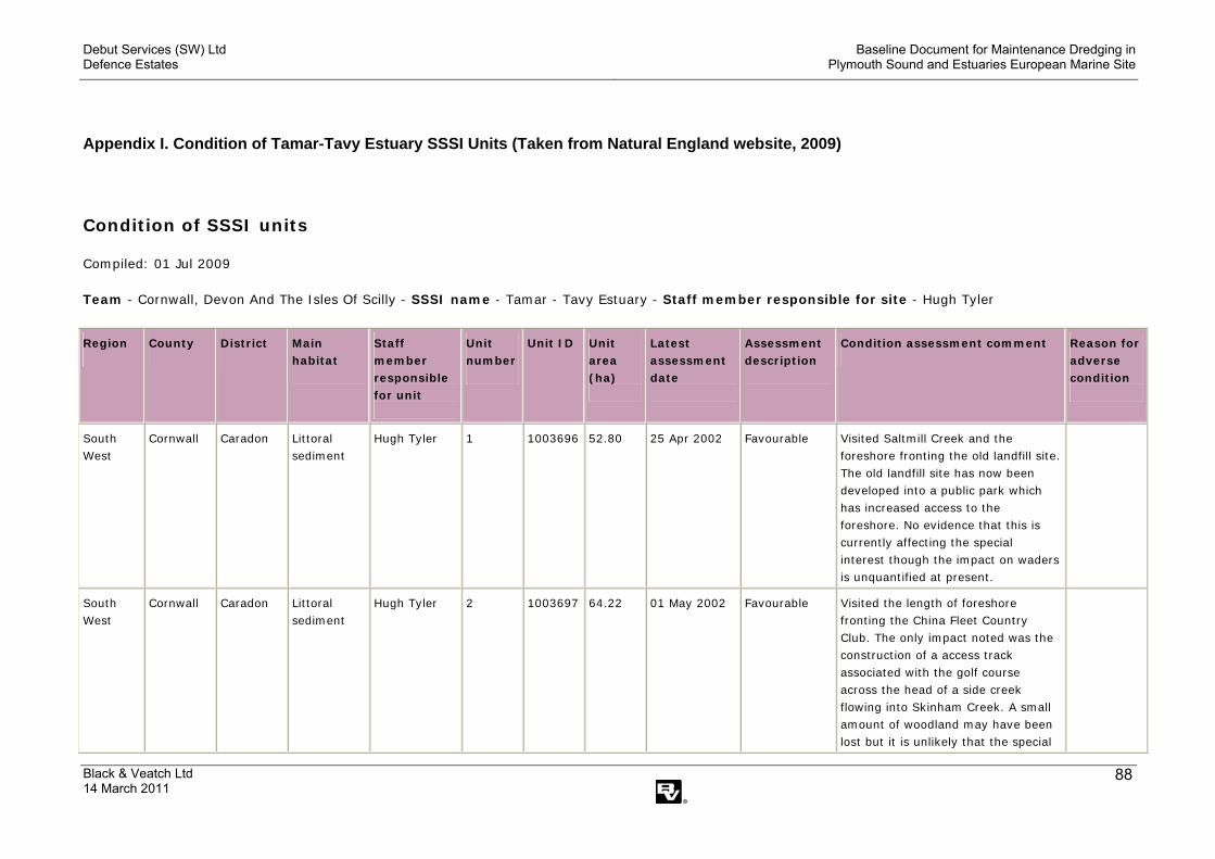
Debut Services (SW) Ltd Defence Estates
Baseline Document for Maintenance Dredging in Plymouth Sound and Estuaries European Marine Site
Black & Veatch Ltd 14 March 2011
88
Appendix I. Condition of Tamar-Tavy Estuary SSSI Units (Taken from Natural England website, 2009)
Condition of SSSI units
Compiled: 01 Jul 2009 Team - Cornwall, Devon And The Isles Of Scilly - SSSI name - Tamar - Tavy Estuary - Staff member responsible for site - Hugh Tyler
Region County
District
Main habitat
Staff member responsible for unit
Unit number
Unit ID Unit area (ha)
Latest assessment date
Assessment description
Condition assessment comment
Reason for adverse condition
South West
Cornwall Caradon Littoral sediment
Hugh Tyler 1 1003696
52.80 25 Apr 2002 Favourable Visited Saltmill Creek and the foreshore fronting the old landfill site. The old landfill site has now been developed into a public park which has increased access to the foreshore. No evidence that this is currently affecting the special interest though the impact on waders is unquantified at present.
South West
Cornwall Caradon Littoral sediment
Hugh Tyler 2 1003697
64.22 01 May 2002 Favourable Visited the length of foreshore fronting the China Fleet Country Club. The only impact noted was the construction of a access track associated with the golf course across the head of a side creek flowing into Skinham Creek. A small amount of woodland may have been lost but it is unlikely that the special
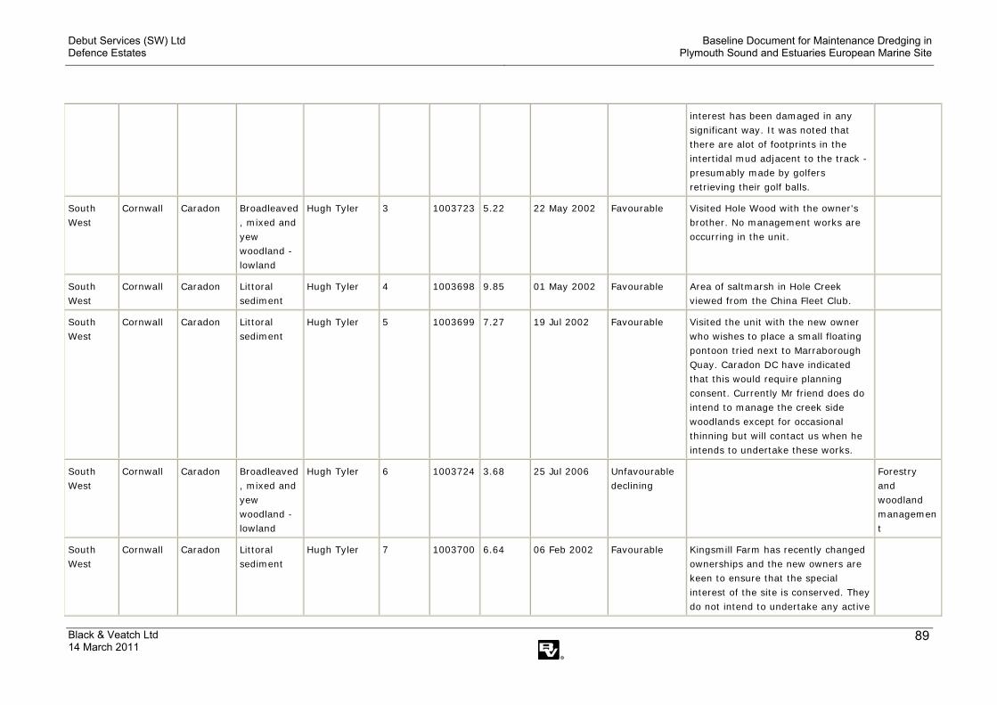
Debut Services (SW) Ltd Defence Estates
Baseline Document for Maintenance Dredging in Plymouth Sound and Estuaries European Marine Site
Black & Veatch Ltd 14 March 2011
89
interest has been damaged in any significant way. It was noted that there are alot of footprints in the intertidal mud adjacent to the track - presumably made by golfers retrieving their golf balls.
South West
Cornwall Caradon Broadleaved, mixed and yew woodland - lowland
Hugh Tyler 3 1003723
5.22 22 May 2002 Favourable Visited Hole Wood with the owner's brother. No management works are occurring in the unit.
South West
Cornwall Caradon Littoral sediment
Hugh Tyler 4 1003698
9.85 01 May 2002 Favourable Area of saltmarsh in Hole Creek viewed from the China Fleet Club.
South West
Cornwall Caradon Littoral sediment
Hugh Tyler 5 1003699
7.27 19 Jul 2002 Favourable Visited the unit with the new owner who wishes to place a small floating pontoon tried next to Marraborough Quay. Caradon DC have indicated that this would require planning consent. Currently Mr friend does do intend to manage the creek side woodlands except for occasional thinning but will contact us when he intends to undertake these works.
South West
Cornwall Caradon Broadleaved, mixed and yew woodland - lowland
Hugh Tyler 6 1003724
3.68 25 Jul 2006 Unfavourable declining
Forestry and woodland management
South West
Cornwall Caradon Littoral sediment
Hugh Tyler 7 1003700
6.64 06 Feb 2002 Favourable Kingsmill Farm has recently changed ownerships and the new owners are keen to ensure that the special interest of the site is conserved. They do not intend to undertake any active

Debut Services (SW) Ltd Defence Estates
Baseline Document for Maintenance Dredging in Plymouth Sound and Estuaries European Marine Site
Black & Veatch Ltd 14 March 2011
90
management within the SSSI except mowing of the grass at the on the old quay.
South West
Cornwall Caradon Littoral sediment
Hugh Tyler 8 1003701
34.59 14 Jun 2002 Favourable Unit viewed from the opposite bank. No grazing animals noted on site.
South West
Cornwall Caradon Fen, marsh and swamp - lowland
Hugh Tyler 9 1003736
13.20 12 Aug 2003 Favourable The unit would benefit from an increase in the number of animals grazing the marsh.
South West
Cornwall Caradon Littoral sediment
Hugh Tyler 10 1003702
64.72 07 Sep 2006 Favourable This unit was viewed from the foreshore. There were not any threats to the favourable condition of this unit although an increase in the number of crab tiles since the 2003/04 survey was recorded. This unit does not contain any areas of saltmarsh or reedbed except a few stray plants near Landulph marsh.
South West
Cornwall Caradon Littoral sediment
Hugh Tyler 11 1003703
28.67 07 Sep 2006 Favourable This unit was viewed from the foreshore except the area immediately adjacent to Cargreen sea walls. The features of interest remain favourable. Crab tile numbers appear unchanged since 2003/04 survey. No saltmarsh or reedbeds within this unit but it was noted that spartina is present in the area to the south of Cargreen (Penyoke) and this needs to be monitored.
South West
Cornwall Caradon Littoral sediment
Hugh Tyler 12 1003704
24.65 07 Sep 2006 Favourable This unit was viewed from the foreshore and by saltmarsh transect. The saltmarsh sections are of good quality although only relatively small areas exist (as expected for this

Debut Services (SW) Ltd Defence Estates
Baseline Document for Maintenance Dredging in Plymouth Sound and Estuaries European Marine Site
Black & Veatch Ltd 14 March 2011
91
location). The mudflats are in favourable condition. It was noted however, that the number of crab tiles in this unit appear to have increased and could become a threat to the condition. It was further noted that Spartina is present at Penyoke, Cargreen that should be monitored more regularly to assess the rate of change in its coverage.
South West
Cornwall Caradon Fen, marsh and swamp - lowland
Hugh Tyler 13 1003737
5.06 27 Jun 2002 Favourable The areas of reedbed, willow carr and intertidal mud are unmanaged.
South West
Cornwall Caradon Littoral sediment
Hugh Tyler 14 1003705
94.67 25 Sep 2006 Favourable The saltmarsh is not grazed, but with the whole of the marsh being inundated at spring tides there is no drying out or losses to terrestrial species. The saltmarsh community of plants is well represented. Spartina is only present on a minority of the site where it is sparse in its coverage. No anthropogenic threats at present.
South West
Cornwall Caradon Broadleaved, mixed and yew woodland - lowland
Hugh Tyler 15 1003725
16.24 25 Mar 2003 Unfavourable recovering
The unconsented pheasant pen has now been removed. The owner would like to felling a small number of oaks which if done correctly and with care will help improve diversity of the woodland canopy.
South West
Cornwall Caradon Fen, marsh and swamp - lowland
Hugh Tyler 16 1003738
9.34 01 Sep 2005 Unfavourable recovering
Part of this unit was damaged. Restoration works have taken place to facilitate recovery.
South West
Cornwall Caradon Littoral sediment
Hugh Tyler 17 1003706
22.36 10 Oct 2006 Favourable There are no saltmarsh or reedbeds within this unit. There appear to be

Debut Services (SW) Ltd Defence Estates
Baseline Document for Maintenance Dredging in Plymouth Sound and Estuaries European Marine Site
Black & Veatch Ltd 14 March 2011
92
no anthropogenic changes or other threats to this unit.
South West
Cornwall Caradon Fen, marsh and swamp - lowland
Hugh Tyler 18 1003739
10.03 30 Jan 2001 Favourable The unit was viewed by boat from the main river channel. There is the occasional piece of boating debris stored on the river frontage close to Chapel Farm which needs monitoring to ensure such storage does not encroach further on to the SSSI.
South West
Cornwall Caradon Fen, marsh and swamp - lowland
Hugh Tyler 19 1003740
18.43 30 Jan 2001 Favourable The agreement land was viewed from a boat. Need to check whether the current reed cutting regime is encouraging reed regeneration or not.
South West
Cornwall Caradon Fen, marsh and swamp - lowland
Hugh Tyler 20 1003741
15.11 09 Nov 2005 Favourable
South West
Cornwall Caradon Broadleaved, mixed and yew woodland - lowland
Hugh Tyler 21 1003726
3.06 16 Feb 2006 Unfavourable recovering
South West
Cornwall Caradon Fen, marsh and swamp - lowland
Hugh Tyler 22 1003742
7.88 06 Mar 2002 Favourable There is a small amount of laurel in the woodland areas which will be cleared under an FC WIGS. Elsewhere the woodland will be managed by non-intervention. The meadow at the western end of the SSSI is managed by summer sheep grazing under a CSS. The grazing levels need to be monitored to ensure the meadow does not become too rank. The reedbed at the eastern
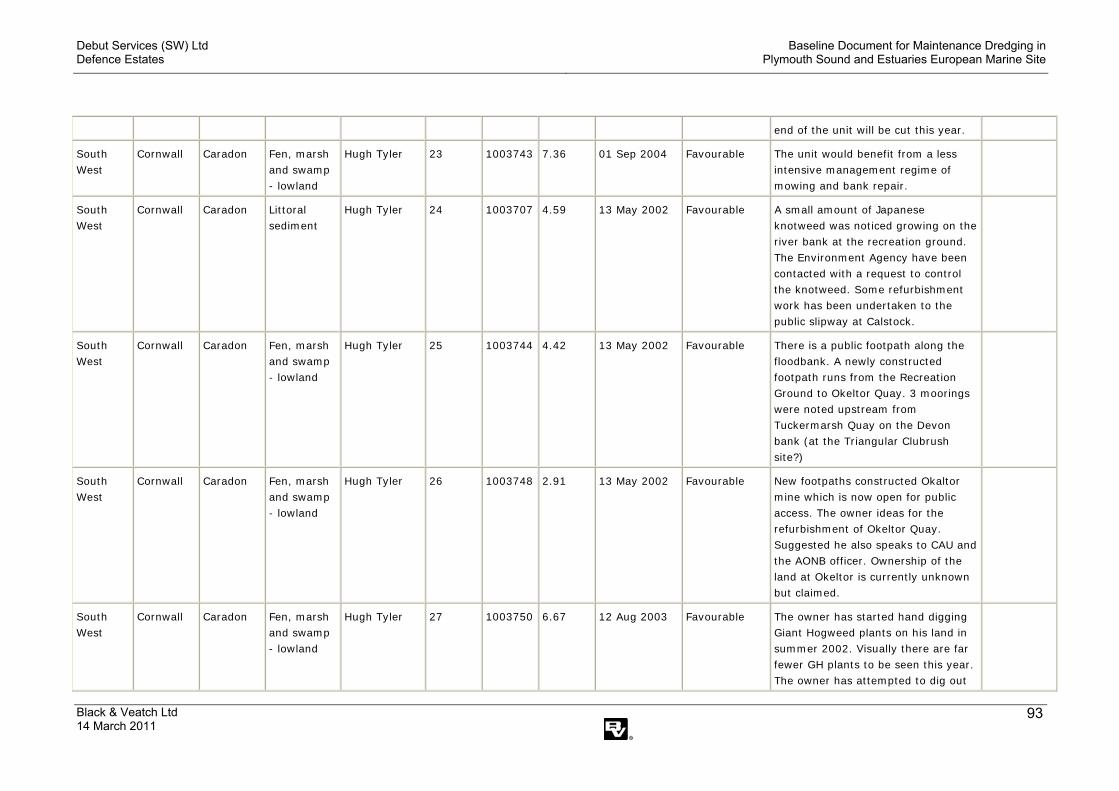
Debut Services (SW) Ltd Defence Estates
Baseline Document for Maintenance Dredging in Plymouth Sound and Estuaries European Marine Site
Black & Veatch Ltd 14 March 2011
93
end of the unit will be cut this year.
South West
Cornwall Caradon Fen, marsh and swamp - lowland
Hugh Tyler 23 1003743
7.36 01 Sep 2004 Favourable The unit would benefit from a less intensive management regime of mowing and bank repair.
South West
Cornwall Caradon Littoral sediment
Hugh Tyler 24 1003707
4.59 13 May 2002 Favourable A small amount of Japanese knotweed was noticed growing on the river bank at the recreation ground. The Environment Agency have been contacted with a request to control the knotweed. Some refurbishment work has been undertaken to the public slipway at Calstock.
South West
Cornwall Caradon Fen, marsh and swamp - lowland
Hugh Tyler 25 1003744
4.42 13 May 2002 Favourable There is a public footpath along the floodbank. A newly constructed footpath runs from the Recreation Ground to Okeltor Quay. 3 moorings were noted upstream from Tuckermarsh Quay on the Devon bank (at the Triangular Clubrush site?)
South West
Cornwall Caradon Fen, marsh and swamp - lowland
Hugh Tyler 26 1003748
2.91 13 May 2002 Favourable New footpaths constructed Okaltor mine which is now open for public access. The owner ideas for the refurbishment of Okeltor Quay. Suggested he also speaks to CAU and the AONB officer. Ownership of the land at Okeltor is currently unknown but claimed.
South West
Cornwall Caradon Fen, marsh and swamp - lowland
Hugh Tyler 27 1003750
6.67 12 Aug 2003 Favourable The owner has started hand digging Giant Hogweed plants on his land in summer 2002. Visually there are far fewer GH plants to be seen this year. The owner has attempted to dig out

Debut Services (SW) Ltd Defence Estates
Baseline Document for Maintenance Dredging in Plymouth Sound and Estuaries European Marine Site
Black & Veatch Ltd 14 March 2011
94
the stand of Japanese knotweed on his flood bank though I have some reservations as to whether this technique will be successful in eradicating the plant. Himalayan balsam is becoming an increasing problem.
South West
Cornwall Caradon Fen, marsh and swamp - lowland
Hugh Tyler 28 1003751
7.18 13 Jun 2002 Favourable The riverside meadows (now dominated by Phragmites) are summer grazed by cattle. Currently the main treat to the special interest of this part of the unit is from long term colonisation by Himalayan Balsam. The Owner is still undertaking some small scale woodland management works mainly weed control beating up around trees planted under the old WGS scheme.
South West
Cornwall Caradon Broadleaved, mixed and yew woodland - lowland
Hugh Tyler 29 1003727
10.55 03 Apr 2002 Favourable Visited the section of Hare Wood owned by Ravenscourt. No active management currently undertaken. The unit would benefit from some rhododendron clearance.
South West
Cornwall Caradon Fen, marsh and swamp - lowland
Hugh Tyler 30 1003754
6.63 24 Apr 2003 Favourable Visited the part of the unit owned by the Old Rectory Coach House. The land comprises rushy meadows behind the river bank which are currently cattle grazed during the summer months. The river bank is heavily infested by Giant Hogweed, Japanese Knotweed and Himalayan Balsam.
South Cornwall Caradon Fen, marsh Hugh Tyler 31 1003756 3.77 09 Feb 2006 Unfavourable
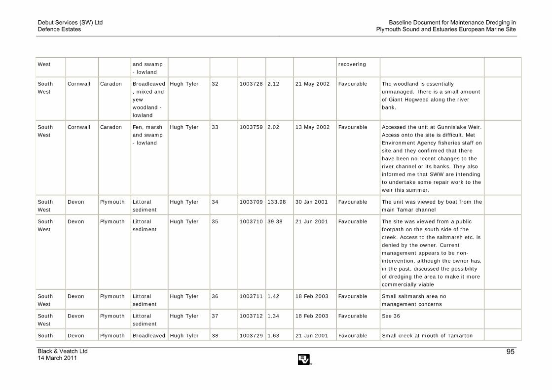
Debut Services (SW) Ltd Defence Estates
Baseline Document for Maintenance Dredging in Plymouth Sound and Estuaries European Marine Site
Black & Veatch Ltd 14 March 2011
95
West and swamp - lowland
recovering
South West
Cornwall Caradon Broadleaved, mixed and yew woodland - lowland
Hugh Tyler 32 1003728
2.12 21 May 2002 Favourable The woodland is essentially unmanaged. There is a small amount of Giant Hogweed along the river bank.
South West
Cornwall Caradon Fen, marsh and swamp - lowland
Hugh Tyler 33 1003759
2.02 13 May 2002 Favourable Accessed the unit at Gunnislake Weir. Access onto the site is difficult. Met Environment Agency fisheries staff on site and they confirmed that there have been no recent changes to the river channel or its banks. They also informed me that SWW are intending to undertake some repair work to the weir this summer.
South West
Devon Plymouth Littoral sediment
Hugh Tyler 34 1003709
133.98 30 Jan 2001 Favourable The unit was viewed by boat from the main Tamar channel
South West
Devon Plymouth Littoral sediment
Hugh Tyler 35 1003710
39.38 21 Jun 2001 Favourable The site was viewed from a public footpath on the south side of the creek. Access to the saltmarsh etc. is denied by the owner. Current management appears to be non-intervention, although the owner has, in the past, discussed the possibility of dredging the area to make it more commercially viable
South West
Devon Plymouth Littoral sediment
Hugh Tyler 36 1003711
1.42 18 Feb 2003 Favourable Small saltmarsh area no management concerns
South West
Devon Plymouth Littoral sediment
Hugh Tyler 37 1003712
1.34 18 Feb 2003 Favourable See 36
South Devon Plymouth Broadleaved Hugh Tyler 38 1003729 1.63 21 Jun 2001 Favourable Small creek at mouth of Tamarton
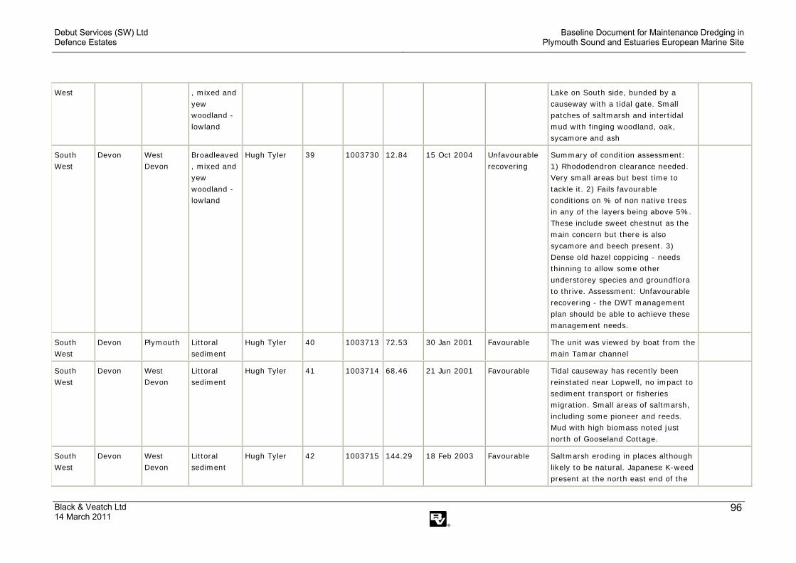
Debut Services (SW) Ltd Defence Estates
Baseline Document for Maintenance Dredging in Plymouth Sound and Estuaries European Marine Site
Black & Veatch Ltd 14 March 2011
96
West , mixed and yew woodland - lowland
Lake on South side, bunded by a causeway with a tidal gate. Small patches of saltmarsh and intertidal mud with finging woodland, oak, sycamore and ash
South West
Devon West Devon
Broadleaved, mixed and yew woodland - lowland
Hugh Tyler 39 1003730
12.84 15 Oct 2004 Unfavourable recovering
Summary of condition assessment: 1) Rhododendron clearance needed. Very small areas but best time to tackle it. 2) Fails favourable conditions on % of non native trees in any of the layers being above 5%. These include sweet chestnut as the main concern but there is also sycamore and beech present. 3) Dense old hazel coppicing - needs thinning to allow some other understorey species and groundflora to thrive. Assessment: Unfavourable recovering - the DWT management plan should be able to achieve these management needs.
South West
Devon Plymouth Littoral sediment
Hugh Tyler 40 1003713
72.53 30 Jan 2001 Favourable The unit was viewed by boat from the main Tamar channel
South West
Devon West Devon
Littoral sediment
Hugh Tyler 41 1003714
68.46 21 Jun 2001 Favourable Tidal causeway has recently been reinstated near Lopwell, no impact to sediment transport or fisheries migration. Small areas of saltmarsh, including some pioneer and reeds. Mud with high biomass noted just north of Gooseland Cottage.
South West
Devon West Devon
Littoral sediment
Hugh Tyler 42 1003715
144.29 18 Feb 2003 Favourable Saltmarsh eroding in places although likely to be natural. Japanese K-weed present at the north east end of the

Debut Services (SW) Ltd Defence Estates
Baseline Document for Maintenance Dredging in Plymouth Sound and Estuaries European Marine Site
Black & Veatch Ltd 14 March 2011
97
site.
South West
Devon West Devon
Fen, marsh and swamp - lowland
Hugh Tyler 43 1003760
4.10 18 Feb 2003 Unfavourable no change
Damage to southern side of the site by a development which may recover. Evidence of possible giant hogweed which will require further investigation. Additional problems with fly tipping on the north west end of the site.
Inappropriate pest control, Water pollution - agriculture/run off
South West
Devon West Devon
Broadleaved, mixed and yew woodland - lowland
Hugh Tyler 44 1003731
26.39 21 Jan 2008 Unfavourable recovering
South West
Devon West Devon
Broadleaved, mixed and yew woodland - lowland
Hugh Tyler 45 1003732
16.41 29 Mar 2005 Unfavourable recovering
A Wildlife Enhancement Scheme agreement has been entered into between EN and the Maristow Estate. The first phase of these works has been completed. This involved the removal of rubbish and the removal and treatment of laurel and rhodo. This works will continue as an annual works programme as agreed between EN and the land owner.
South West
Devon West Devon
Littoral sediment
Hugh Tyler 46 1003716
38.56 30 Jan 2001 Favourable The unit was viewed by boat from the main Tamar channel
South West
Devon West Devon
Littoral sediment
Hugh Tyler 47 1003717
86.37 30 Jan 2001 Favourable The unit was viewed by boat from the main Tamar channel
South West
Devon West Devon
Fen, marsh and swamp - lowland
Hugh Tyler 48 1003763
2.83 18 Feb 2003 Favourable Saltmarsh and woodland in favourable condition. Only problem was with rubbish building up from estuary debris.
South Devon West Littoral Hugh Tyler 49 1003718 19.46 30 Jan 2001 Favourable The unit was viewed by boat from the

Debut Services (SW) Ltd Defence Estates
Baseline Document for Maintenance Dredging in Plymouth Sound and Estuaries European Marine Site
Black & Veatch Ltd 14 March 2011
98
West Devon sediment main Tamar channel. No new development at boatyard.
South West
Devon West Devon
Littoral sediment
Hugh Tyler 50 1003719
8.57 30 Jan 2001 Favourable The unit was viewed by boat from the main Tamar channel. Two house boats on foreshore, appeared to be no further structures added, electricity cables and water pipes remaining.
South West
Devon West Devon
Broadleaved, mixed and yew woodland - lowland
Hugh Tyler 51 1003733
4.46 20 Oct 2004 Favourable Overall condition is favourable. However the following need to be addressed: 1) Small section of hedge laying required on NE edge of unit to thicken hedge and prevent animals from escaping into woodland. 2) Sweet chestnut not a problem at the moment but would be preferable to fell some of the large sweet chestnut to prevent spread. Best to fell specimens which are higher up the slope first as seeds will always make their way down slope. Investigate ways of achieving this. Woodland Grant Scheme?
South West
Devon West Devon
Littoral sediment
Hugh Tyler 52 1003720
65.30 30 Jan 2001 Favourable The unit was viewed by boat from the main Tamar channel.
South West
Devon West Devon
Fen, marsh and swamp - lowland
Hugh Tyler 53 1003767
15.17 30 Jan 2001 Favourable The unit was viewed by boat from the main Tamar channel.
South West
Devon West Devon
Fen, marsh and swamp - lowland
Hugh Tyler 54 1003765
11.17 30 Jan 2001 Favourable The unit was viewed by boat from the main Tamar channel.
South Devon West Broadleaved Hugh Tyler 55 1003734 4.92 19 Feb 2003 Favourable Woodland not of SSSI quality. small.

Debut Services (SW) Ltd Defence Estates
Baseline Document for Maintenance Dredging in Plymouth Sound and Estuaries European Marine Site
Black & Veatch Ltd 14 March 2011
99
West Devon , mixed and yew woodland - lowland
Mostly beech canopy no particularly old trees. not good age structure. Sweet chestnut on edge of wood. Some laurel, oak, hazel, ash. Regen mostly beech. shrub layer mostly holly. blue bells and violet on edge. No visible mgt. dead wood left. Future management recommendations: if considered important enough could improve quality of woodland using WGS or WES? Kill off some of big beech and regeneration. maybe fell beech around oaks to allow them to regen.
South West
Devon West Devon
Fen, marsh and swamp - lowland
Hugh Tyler 56 1003768
11.33 30 Jan 2001 Favourable The unit was viewed by boat from the main Tamar channel.
South West
Devon West Devon
Broadleaved, mixed and yew woodland - lowland
Hugh Tyler 57 1003735
10.26 21 Jun 2001 Favourable
South West
Devon West Devon
Fen, marsh and swamp - lowland
Hugh Tyler 58 1003770
2.26 20 Jun 2001 Favourable Rich mud with diatoms and bedrock with abundant hydroids under shady overhangs at LW
South West
Devon West Devon
Fen, marsh and swamp - lowland
Hugh Tyler 59 1003776
1.57 20 Jun 2001 Favourable
South West
Devon West Devon
Fen, marsh and swamp - lowland
Hugh Tyler 60 1003771
12.19 20 Jun 2001 Favourable Bedrock, rich mud banks, phraqmites, willow carr with nice transitions
South Devon West Fen, marsh Hugh Tyler 61 1003772 17.79 15 Dec 2004 Unfavourable Agreed management in place to
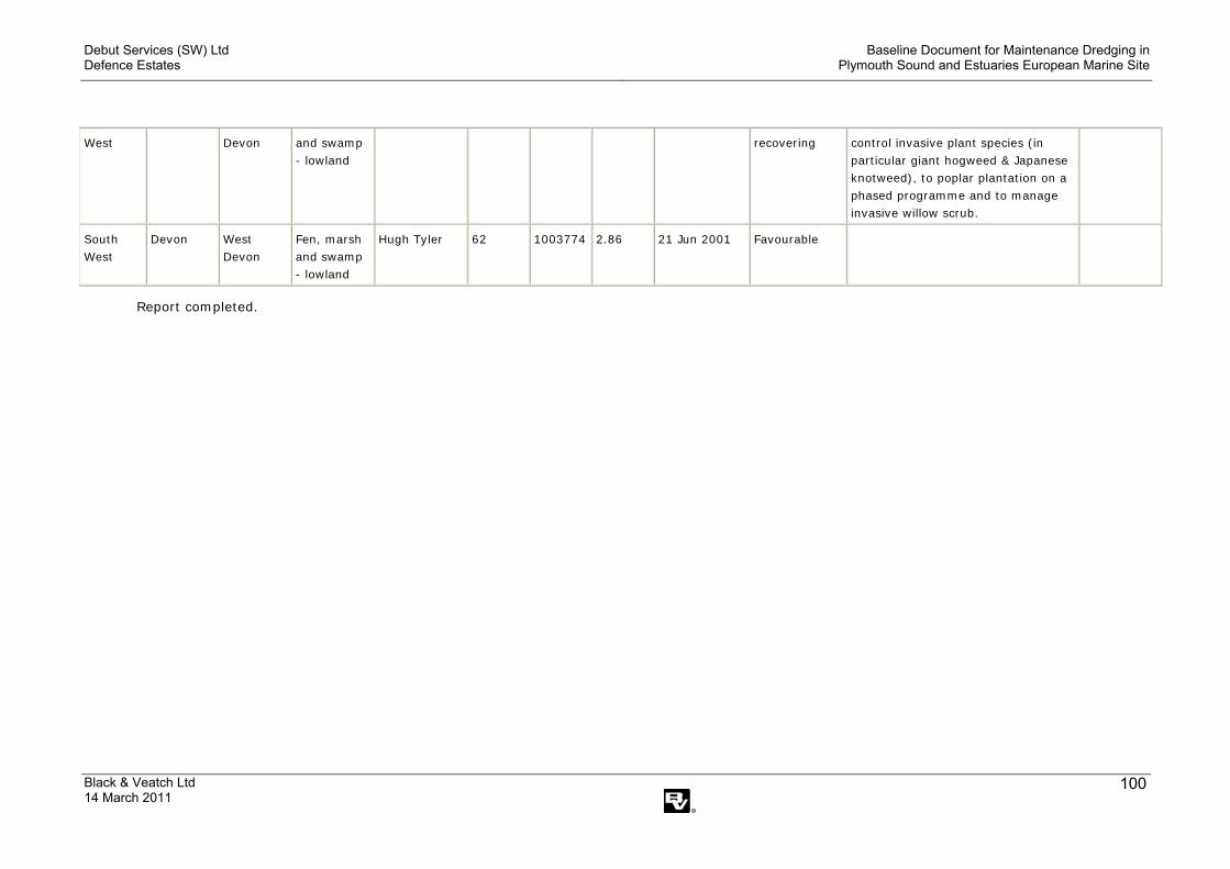
Debut Services (SW) Ltd Defence Estates
Baseline Document for Maintenance Dredging in Plymouth Sound and Estuaries European Marine Site
Black & Veatch Ltd 14 March 2011
100
West Devon and swamp - lowland
recovering control invasive plant species (in particular giant hogweed & Japanese knotweed), to poplar plantation on a phased programme and to manage invasive willow scrub.
South West
Devon West Devon
Fen, marsh and swamp - lowland
Hugh Tyler 62 1003774
2.86 21 Jun 2001 Favourable
Report completed.
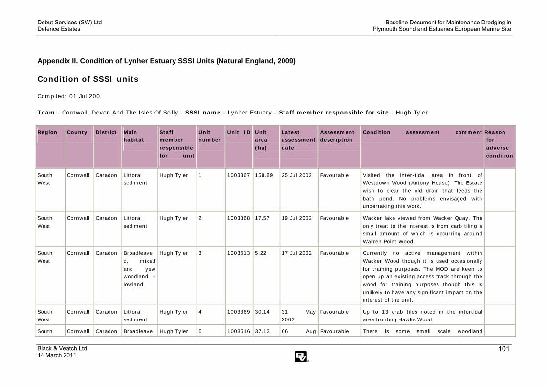
Debut Services (SW) Ltd Defence Estates
Baseline Document for Maintenance Dredging in Plymouth Sound and Estuaries European Marine Site
Black & Veatch Ltd 14 March 2011
101
Appendix II. Condition of Lynher Estuary SSSI Units (Natural England, 2009)
Condition of SSSI units
Compiled: 01 Jul 200 Team - Cornwall, Devon And The Isles Of Scilly - SSSI name - Lynher Estuary - Staff member responsible for site - Hugh Tyler
Region County District Main habitat
Staff member responsible for unit
Unit number
Unit ID Unit area (ha)
Latest assessment date
Assessment description
Condition assessment comment
Reason for adverse condition
South West
Cornwall Caradon Littoral sediment
Hugh Tyler 1 1003367
158.89 25 Jul 2002 Favourable Visited the inter-tidal area in front of Westdown Wood (Antony House). The Estate wish to clear the old drain that feeds the bath pond. No problems envisaged with undertaking this work.
South West
Cornwall Caradon Littoral sediment
Hugh Tyler 2 1003368
17.57 19 Jul 2002 Favourable Wacker lake viewed from Wacker Quay. The only treat to the interest is from carb tiling a small amount of which is occurring around Warren Point Wood.
South West
Cornwall Caradon Broadleaved, mixed and yew woodland - lowland
Hugh Tyler 3 1003513
5.22 17 Jul 2002 Favourable Currently no active management within Wacker Wood though it is used occasionally for training purposes. The MOD are keen to open up an existing access track through the wood for training purposes though this is unlikely to have any significant impact on the interest of the unit.
South West
Cornwall Caradon Littoral sediment
Hugh Tyler 4 1003369
30.14 31 May 2002
Favourable Up to 13 crab tiles noted in the intertidal area fronting Hawks Wood.
South Cornwall Caradon Broadleave Hugh Tyler 5 1003516 37.13 06 Aug Favourable There is some small scale woodland

Debut Services (SW) Ltd Defence Estates
Baseline Document for Maintenance Dredging in Plymouth Sound and Estuaries European Marine Site
Black & Veatch Ltd 14 March 2011
102
West d, mixed and yew woodland - lowland
2002 management o The main threat to the special interest in long term colonisation by rhododendron and the absence of positive management to remove non-native trees. Much of the unit still supports excellent examples of W10 and W16 communities. However in large sections of the woodland beech and sweet chestnut occupy significant component within the community. There has been some recent unconsented track improvement work, pond construction and construction of a pheasant pen within the SSSI.
South West
Cornwall Caradon Littoral sediment
Hugh Tyler 6 1003370
23.25 16 May 2006
Favourable
South West
Cornwall Caradon Littoral sediment
Hugh Tyler 7 1003371
11.98 03 Oct 2001 Favourable Visited the area of saltmarsh just to the east of the boatyard. The visit was made with a representative from an ecological consultancy to undertake a saltmarsh transect. Over much of the area the saltmarsh vegetation is characterised by Festuca rubra and Agrostis stolonifera. The barge on Polbathic Turf remains.
South West
Cornwall Caradon Littoral sediment
Hugh Tyler 8 1003372
11.25 19 Feb 2003
Favourable Sheep graze the saltmarsh from the adjacent fields for a couple of months during winter (grazier) as had been previously established (SMS) with previous tenant. Consent for this issued following visit.
South West
Cornwall Caradon Littoral sediment
Hugh Tyler 9 1003373
12.87 10 Sep 2002
Favourable There is no obvious management occurring within the unit. The saltmarsh areas are characterised by sea purslane, sea couch, sea aster, common cord-grass and sea club-rush. The majority of the unit is open mud-
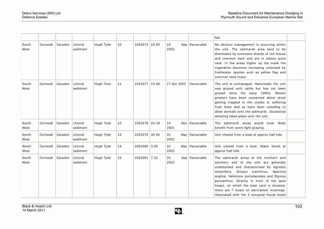
Debut Services (SW) Ltd Defence Estates
Baseline Document for Maintenance Dredging in Plymouth Sound and Estuaries European Marine Site
Black & Veatch Ltd 14 March 2011
103
flat.
South West
Cornwall Caradon Littoral sediment
Hugh Tyler 10 1003374
15.56 10 Sep 2002
Favourable No obvious management is occurring within the unit. The saltmarsh area tend to be dominated by extensive stands of red fescue and common bent and are in places quite rank. In the areas higher up the creek the vegetation becomes increasing colonised by freshwater species such as yellow flag and common reed-mace.
South West
Cornwall Caradon Littoral sediment
Hugh Tyler 11 1003377
10.58 17 Oct 2002 Favourable The unit is unmanaged. Historically the unit was grazed with cattle but has not been grazed since the early 1980s. Recent graziers have been concerned about stock getting trapped in the creeks or suffering from fluke and so have been unwilling to allow animals onto the saltmarsh. Occasional shooting takes place over the unit.
South West
Cornwall Caradon Littoral sediment
Hugh Tyler 12 1003378
25.18 14 Nov 2001
Favourable The saltmarsh areas would most likely benefit from some light grazing.
South West
Cornwall Caradon Littoral sediment
Hugh Tyler 13 1003379
30.50 31 May 2002
Favourable Unit viewed from a boat at approx half tide.
South West
Cornwall Caradon Littoral sediment
Hugh Tyler 14 1003380
3.35 31 May 2002
Favourable Unit viewed from a boat. Water levels at approx half tide.
South West
Cornwall Caradon Littoral sediment
Hugh Tyler 15 1003381
7.22 24 Sep 2002
Favourable The saltmarsh areas at the northern and southern end of the unit are generally undisturbed and characterised by Agrostis stolonifera, Scirpus maritimus, Spartina anglica, Helimone portulacoides and Elymus pycnanthus. Directly in front of the spoil heaps, on which the boat yard is situated, there are 7 boats on permanent moorings. Associated with the 2 occupied house boats
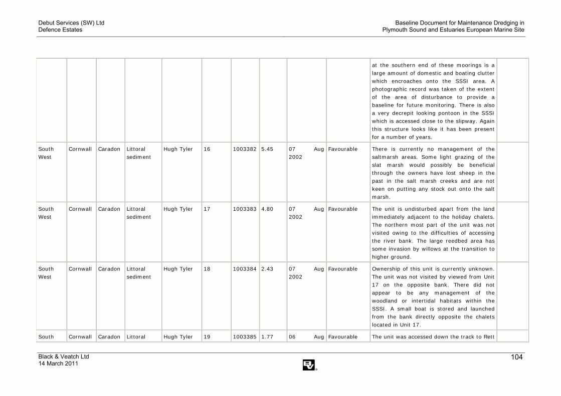
Debut Services (SW) Ltd Defence Estates
Baseline Document for Maintenance Dredging in Plymouth Sound and Estuaries European Marine Site
Black & Veatch Ltd 14 March 2011
104
at the southern end of these moorings is a large amount of domestic and boating clutter which encroaches onto the SSSI area. A photographic record was taken of the extent of the area of disturbance to provide a baseline for future monitoring. There is also a very decrepit looking pontoon in the SSSI which is accessed close to the slipway. Again this structure looks like it has been present for a number of years.
South West
Cornwall Caradon Littoral sediment
Hugh Tyler 16 1003382
5.45 07 Aug 2002
Favourable There is currently no management of the saltmarsh areas. Some light grazing of the slat marsh would possibly be beneficial through the owners have lost sheep in the past in the salt marsh creeks and are not keen on putting any stock out onto the salt marsh.
South West
Cornwall Caradon Littoral sediment
Hugh Tyler 17 1003383
4.80 07 Aug 2002
Favourable The unit is undisturbed apart from the land immediately adjacent to the holiday chalets. The northern most part of the unit was not visited owing to the difficulties of accessing the river bank. The large reedbed area has some invasion by willows at the transition to higher ground.
South West
Cornwall Caradon Littoral sediment
Hugh Tyler 18 1003384
2.43 07 Aug 2002
Favourable Ownership of this unit is currently unknown. The unit was not visited by viewed from Unit 17 on the opposite bank. There did not appear to be any management of the woodland or intertidal habitats within the SSSI. A small boat is stored and launched from the bank directly opposite the chalets located in Unit 17.
South Cornwall Caradon Littoral Hugh Tyler 19 1003385 1.77 06 Aug Favourable The unit was accessed down the track to Rett

Debut Services (SW) Ltd Defence Estates
Baseline Document for Maintenance Dredging in Plymouth Sound and Estuaries European Marine Site
Black & Veatch Ltd 14 March 2011
105
West sediment 2002 Wood. The unit is primarily comprised of inter-tidal mud flat and was viewed from the old quarry track. The river bank is difficult to access however there is no obvious sign that of any management activity within the unit.
South West
Cornwall Caradon Littoral sediment
Hugh Tyler 20 1003386
3.99 06 Aug 2002
Favourable Part of the unit, namely the creek in front of Bagmill Barn has been sold. The new owner 3 boats moored within the creek. Another boat has been moored at Cumble Tor Quay. There is a small amount of occasional cattle grazing of the salt marsh just downstream from Cumble Tor Quay. An old farm dump is located on the river bank just downstream of Bagmill Barn.
South West
Cornwall Caradon Littoral sediment
Hugh Tyler 21 1003387
4.53 31 May 2002
Favourable Unit viewed from a boat at approximately half tide.
South West
Cornwall Caradon Littoral sediment
Hugh Tyler 22 1003388
36.21 07 May 2009
Favourable An area of ungrazed saltmarsh which is characterized by upper and mid marsh plant communities.
South West
Cornwall Caradon Littoral sediment
Hugh Tyler 23 1003389
32.66 13 May 2009
Favourable An area of ungrazed saltmarsh dominated by mid and upper marsh communities
South West
Cornwall Caradon Littoral sediment
Hugh Tyler 24 1003390
98.45 31 May 2002
Favourable Up to 70 crab tiles noted in the stretch of intertidal mud from the quay at Earth Hill downstream to the bend in the river.
South West
Cornwall Caradon Littoral sediment
Hugh Tyler 25 1003391
49.80 13 Aug 2002
Favourable Unit viewed from the north bank of Wivelscombe Lake at around high water. No evidence of any management activity occurring within the unit. A large pontoon is present near the western end of the unit just to the west of the culvet under the disused rail track. Judging by the condition of the pontoon it looks like it may have been
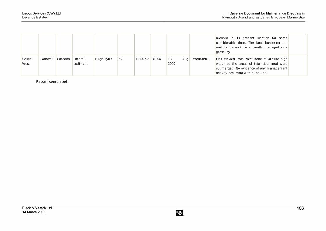
Debut Services (SW) Ltd Defence Estates
Baseline Document for Maintenance Dredging in Plymouth Sound and Estuaries European Marine Site
Black & Veatch Ltd 14 March 2011
106
moored in its present location for some considerable time. The land bordering the unit to the north is currently managed as a grass ley.
South West
Cornwall Caradon Littoral sediment
Hugh Tyler 26 1003392
31.84 13 Aug 2002
Favourable Unit viewed from west bank at around high water so the areas of inter-tidal mud were submerged. No evidence of any management activity occurring within the unit.
Report completed.

Debut Services (SW) Ltd Defence Estates
Baseline Document for Maintenance Dredging in Plymouth Sound and Estuaries European Marine Site
Black & Veatch Ltd 14 March 2011
107
Appendix III. Condition Assessment of St John’s Lake SSSI Units
Condition of SSSI units
Compiled: 01 Jul 2009
See the SSSI glossary for an explanation of terms.
Team - Cornwall, Devon And The Isles Of Scilly - SSSI name - St John's Lake - Staff member responsible for site - Hugh Tyler Region County
District Main habitat
Staff member responsible for unit
Unit number
Unit ID Unit area (ha)
Latest assessment date
Assessment description
Condition assessment comment
Reason for adverse condition
South West
Cornwall Caradon Littoral sediment
Hugh Tyler 1 1003052
14.05 15 Jan 2002 Favourable The saltmarsh in Insworke Lake id dominated by Spartina. There is some evidence that sheep have escaped from the adjoining land onto the intertidal mud and saltmarsh though no long term impact is envisaged.
South West
Cornwall Caradon Littoral sediment
Hugh Tyler 2 1003053
123.28 15 Jan 2002 Favourable There is no active management of this unit. A small amount of Spartina is present in the bay south of Sango Island.
South West
Cornwall Caradon Littoral sediment
Hugh Tyler 3 1021028
129.11 03 Oct 2001 Favourable Visited the saltmarsh areas at the western end of the unit around the causeway to St John's. The saltmarsh on the north side of the estuary is dominated almost exclusively by Spartina with occasional patches of Halimione portulacoides and Salicornia. It is no clear if there is long term loss of saltmarsh in this area. To the west of the

Debut Services (SW) Ltd Defence Estates
Baseline Document for Maintenance Dredging in Plymouth Sound and Estuaries European Marine Site
Black & Veatch Ltd 14 March 2011
108
road causeway in the creek the saltmarsh is dominated by Halimione with Spartina invading.
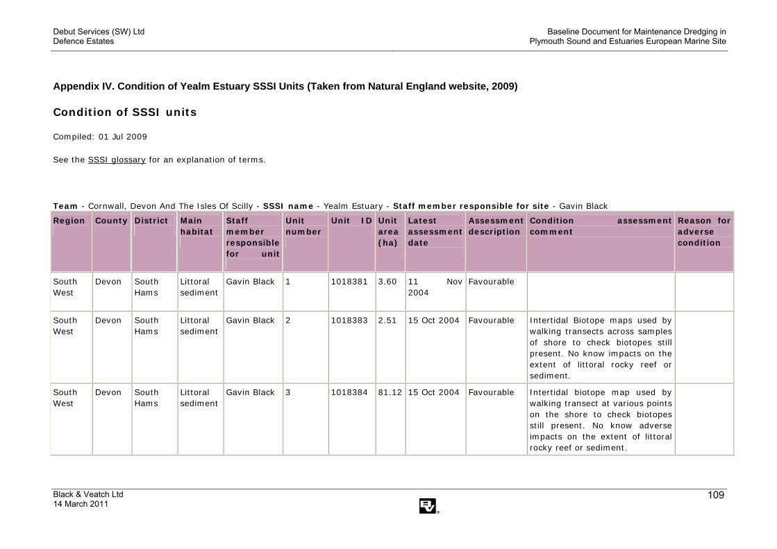
Debut Services (SW) Ltd Defence Estates
Baseline Document for Maintenance Dredging in Plymouth Sound and Estuaries European Marine Site
Black & Veatch Ltd 14 March 2011
109
Appendix IV. Condition of Yealm Estuary SSSI Units (Taken from Natural England website, 2009)
Condition of SSSI units
Compiled: 01 Jul 2009
See the SSSI glossary for an explanation of terms.
Team - Cornwall, Devon And The Isles Of Scilly - SSSI name - Yealm Estuary - Staff member responsible for site - Gavin Black Region County District
Main habitat
Staff member responsible for unit
Unit number
Unit ID
Unit area (ha)
Latest assessment date
Assessment description
Condition assessment comment
Reason for adverse condition
South West
Devon South Hams
Littoral sediment
Gavin Black 1 1018381 3.60 11 Nov 2004
Favourable
South West
Devon South Hams
Littoral sediment
Gavin Black 2 1018383 2.51 15 Oct 2004 Favourable Intertidal Biotope maps used by walking transects across samples of shore to check biotopes still present. No know impacts on the extent of littoral rocky reef or sediment.
South West
Devon South Hams
Littoral sediment
Gavin Black 3 1018384 81.12
15 Oct 2004 Favourable Intertidal biotope map used by walking transect at various points on the shore to check biotopes still present. No know adverse impacts on the extent of littoral rocky reef or sediment.

Debut Services (SW) Ltd Defence Estates
Baseline Document for Maintenance Dredging in Plymouth Sound and Estuaries European Marine Site
Black & Veatch Ltd 14 March 2011
110
Appendix V. Condition of Western King SSSI Units (Taken from Natural England website, 2009)
Condition of SSSI units
Compiled: 01 Jul 2009
See the SSSI glossary for an explanation of terms.
Team - Cornwall, Devon And The Isles Of Scilly - SSSI name - Western King - Staff member responsible for site - Simon Dunsford Region County District
Main habitat
Staff member responsible for unit
Unit number
Unit ID
Unit area (ha)
Latest assessment date
Assessment description
Condition assessment comment
Reason for adverse condition
South West
Devon Plymouth Earth heritage
Simon Dunsford
1 1004162 1.83 04 Feb 2009
Favourable The exposures remain virtually continuous throughout the site. These are wave-washed and little vegetation is growing. There are no construction works apart from pre-existing bunkers and some concrete pipes, which do not compromise the interest of the site as a whole.
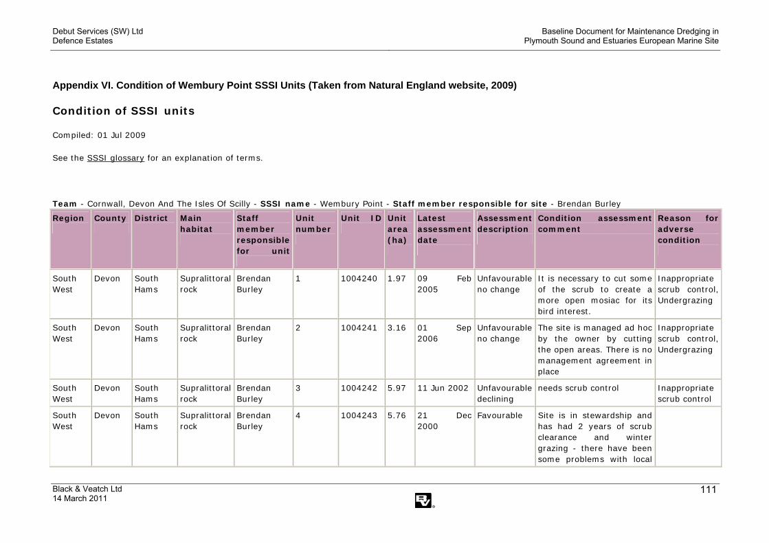
Debut Services (SW) Ltd Defence Estates
Baseline Document for Maintenance Dredging in Plymouth Sound and Estuaries European Marine Site
Black & Veatch Ltd 14 March 2011
111
Appendix VI. Condition of Wembury Point SSSI Units (Taken from Natural England website, 2009)
Condition of SSSI units
Compiled: 01 Jul 2009
See the SSSI glossary for an explanation of terms.
Team - Cornwall, Devon And The Isles Of Scilly - SSSI name - Wembury Point - Staff member responsible for site - Brendan Burley Region County District
Main habitat
Staff member responsible for unit
Unit number
Unit ID
Unit area (ha)
Latest assessment date
Assessment description
Condition assessment comment
Reason for adverse condition
South West
Devon South Hams
Supralittoral rock
Brendan Burley
1 1004240 1.97 09 Feb 2005
Unfavourable no change
It is necessary to cut some of the scrub to create a more open mosiac for its bird interest.
Inappropriate scrub control, Undergrazing
South West
Devon South Hams
Supralittoral rock
Brendan Burley
2 1004241 3.16 01 Sep 2006
Unfavourable no change
The site is managed ad hoc by the owner by cutting the open areas. There is no management agreement in place
Inappropriate scrub control, Undergrazing
South West
Devon South Hams
Supralittoral rock
Brendan Burley
3 1004242 5.97 11 Jun 2002 Unfavourable declining
needs scrub control Inappropriate scrub control
South West
Devon South Hams
Supralittoral rock
Brendan Burley
4 1004243 5.76 21 Dec 2000
Favourable Site is in stewardship and has had 2 years of scrub clearance and winter grazing - there have been some problems with local

Debut Services (SW) Ltd Defence Estates
Baseline Document for Maintenance Dredging in Plymouth Sound and Estuaries European Marine Site
Black & Veatch Ltd 14 March 2011
112
concerns for animal welfare and an instance of overstocking has occurred. Welfare cull took place during FMD outbreak.
South West
Devon South Hams
Supralittoral rock
Brendan Burley
5 1004245 7.04 01 Sep 2006
Unfavourable no change
No management on this site currently - It is understood to be changing ownership about now.
Inappropriate scrub control, Undergrazing
South West
Devon South Hams
Supralittoral rock
Brendan Burley
6 1004247 20.22
14 Mar 2001
Favourable The MOD have been carrying out scrub clearance on the site for a couple of years - recent cutting has been agreed/consented to facilitate an MOD survey to assess the presence/quantity of ordnance that may be present on the site - The MOD are currently in the process of decomissioning the site, which could present management changes/problems for the future
South West
Devon South Hams
Supralittoral rock
Brendan Burley
7 1004248 1.43 11 Jun 2002 Unfavourable declining
Inappropriate scrub control
South West
Devon South Hams
Supralittoral rock
Brendan Burley
8 1004249 1.20 11 Jun 2002 Unfavourable declining
Inappropriate scrub control
South West
Devon South Hams
Supralittoral rock
Brendan Burley
9 1004250 8.02 09 Jan 2001 Favourable Met with manager and walked the site to look at recent scrub clearance

Debut Services (SW) Ltd Defence Estates
Baseline Document for Maintenance Dredging in Plymouth Sound and Estuaries European Marine Site
Black & Veatch Ltd 14 March 2011
113
work. The clearance has created significant clearings and glades - additional work will be carried out over the next few weeks at the north end of the site and fencing completed around the woodland section. No cattle are grazing at present, the manager doesn't currently have suitable winter stock.
South West
Devon South Hams
Supralittoral rock
Brendan Burley
10 1004251 3.61 11 Jun 2002 Unfavourable declining
Inappropriate scrub control
South West
Devon South Hams
Supralittoral rock
Brendan Burley
11 1004253 26.54
09 Jan 2001 Favourable Maritime grassland has recovered well, grazing continues with sheep and Dartmoor Ponies - grazing appears to be maintaining a 5/10cm sward height and preventing further scrub encroachment
South West
Devon South Hams
Littoral sediment
Brendan Burley
12 1021641 53.76
09 Sep 2001
Favourable

Debut Services (SW) Ltd Defence Estates
Baseline Document for Maintenance Dredging in Plymouth Sound and Estuaries European Marine Site
Black & Veatch Ltd 14 March 2011
114
Appendix VII. Condition of Kingsand to Sandway Point SSSI Units (Taken from Natural England website, 2009)
Condition of SSSI units
Compiled: 01 Jul 2009
See the SSSI glossary for an explanation of terms.
Team - Cornwall, Devon And The Isles Of Scilly - SSSI name - Kingsand To Sandway Point - Staff member responsible for site - Hugh Tyler Region County
District
Main habitat
Staff member responsible for unit
Unit number
Unit ID
Unit area (ha)
Latest assessment date
Assessment description
Condition assessment comment
Reason for adverse condition
South West
Cornwall Caradon Earth heritage
Hugh Tyler 1 1003605 3.54 30 Nov 2004
Favourable The features of interest remain exposed. No evidence of tipping of garden refuse or fly tipping on day of visit. No additional (post notification) coastal defences or development associated with the village of Kingsand or the hut foundations evident on day of visit. No evidence of specimen collecting noted. Hence 'favourable' condition assessment.
South West
Cornwall Caradon Earth heritage
Hugh Tyler 2 1020627 2.75 30 Nov 2004
Favourable The features of interest remain exposed. No evidence of tipping of garden refuse or fly tipping on day of visit. No additional (post notification) coastal defences or

Debut Services (SW) Ltd Defence Estates
Baseline Document for Maintenance Dredging in Plymouth Sound and Estuaries European Marine Site
Black & Veatch Ltd 14 March 2011
115
development associated with the village of Kingsand or the hut foundations evident on day of visit. No evidence of specimen collecting noted. Hence 'favourable' condition assessment.
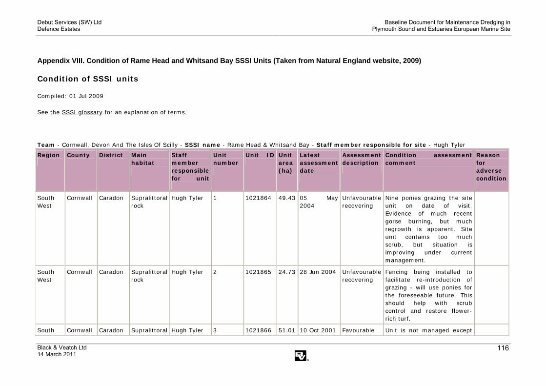
Debut Services (SW) Ltd Defence Estates
Baseline Document for Maintenance Dredging in Plymouth Sound and Estuaries European Marine Site
Black & Veatch Ltd 14 March 2011
116
Appendix VIII. Condition of Rame Head and Whitsand Bay SSSI Units (Taken from Natural England website, 2009)
Condition of SSSI units
Compiled: 01 Jul 2009
See the SSSI glossary for an explanation of terms.
Team - Cornwall, Devon And The Isles Of Scilly - SSSI name - Rame Head & Whitsand Bay - Staff member responsible for site - Hugh Tyler Region County
District
Main habitat
Staff member responsible for unit
Unit number
Unit ID
Unit area (ha)
Latest assessment date
Assessment description
Condition assessment comment
Reason for adverse condition
South West
Cornwall Caradon Supralittoral rock
Hugh Tyler 1 1021864 49.43
05 May 2004
Unfavourable recovering
Nine ponies grazing the site unit on date of visit. Evidence of much recent gorse burning, but much regrowth is apparent. Site unit contains too much scrub, but situation is improving under current management.
South West
Cornwall Caradon Supralittoral rock
Hugh Tyler 2 1021865 24.73
28 Jun 2004 Unfavourable recovering
Fencing being installed to facilitate re-introduction of grazing - will use ponies for the foreseeable future. This should help with scrub control and restore flower-rich turf.
South Cornwall Caradon Supralittoral Hugh Tyler 3 1021866 51.01 10 Oct 2001 Favourable Unit is not managed except

Debut Services (SW) Ltd Defence Estates
Baseline Document for Maintenance Dredging in Plymouth Sound and Estuaries European Marine Site
Black & Veatch Ltd 14 March 2011
117
West rock from strimming of vegetation along the cliff path. The unit is characterised by gorse, bracken and blackthorn scrub. The topography is generally steep which would make any sort of more widespread vegetation management difficult. The MOD section of the unit was not visited.
South West
Cornwall Caradon Supralittoral rock
Hugh Tyler 4 1021867 35.89
10 Oct 2001 Unfavourable recovering
The areas above the cliff slopes are being managed as part of larger grazing units. Management includes grazing and some scrub cutting. Most of the land above the cliff edge is managed under a CSS agreement. Vegetation on the cliffs themselves tend to be dominated by gorse and bracken with occasional blackthorn scrub.
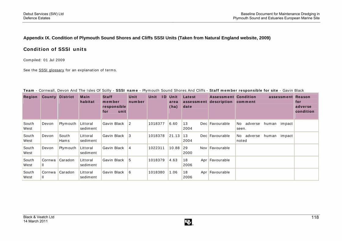
Debut Services (SW) Ltd Defence Estates
Baseline Document for Maintenance Dredging in Plymouth Sound and Estuaries European Marine Site
Black & Veatch Ltd 14 March 2011
118
Appendix IX. Condition of Plymouth Sound Shores and Cliffs SSSI Units (Taken from Natural England website, 2009)
Condition of SSSI units
Compiled: 01 Jul 2009
See the SSSI glossary for an explanation of terms.
Team - Cornwall, Devon And The Isles Of Scilly - SSSI name - Plymouth Sound Shores And Cliffs - Staff member responsible for site - Gavin Black Region County District
Main habitat
Staff member responsible for unit
Unit number
Unit ID
Unit area (ha)
Latest assessment date
Assessment description
Condition assessment comment
Reason for adverse condition
South West
Devon Plymouth Littoral sediment
Gavin Black 2 1018377 6.60 13 Dec 2004
Favourable No adverse human impact seen.
South West
Devon South Hams
Littoral sediment
Gavin Black 3 1018378 21.13
13 Dec 2004
Favourable No adverse human impact noted
South West
Devon Plymouth Littoral sediment
Gavin Black 4 1022311 10.88
29 Nov 2000
Favourable
South West
Cornwall
Caradon Littoral sediment
Gavin Black 5 1018379 4.63 18 Apr 2006
Favourable
South West
Cornwall
Caradon Littoral sediment
Gavin Black 6 1018380 1.06 18 Apr 2006
Favourable

Debut Services (SW) Ltd Defence Estates
Baseline Document for Maintenance Dredging in Plymouth Sound and Estuaries European Marine Site
Black & Veatch Ltd 14 March 2011
119

Debut Services (SW) Ltd Defence Estates
Baseline Document for Maintenance Dredging in Plymouth Sound and Estuaries European Marine Site
Black & Veatch Ltd 14 March 2011
120
Appendix X – Westminster Dredging Sites and Register – HMNB Devonport
Debut Services (SW) Ltd Defence Estates
Baseline Document for Maintenance Dredging in Plymouth Sound and Estuaries European Marine Site
Black & Veatch Ltd 14 March 2011
121
This page is left intentionally blank

Debut Services (SW) Ltd Defence Estates
Baseline Document for Maintenance Dredging in Plymouth Sound and Estuaries European Marine Site
Black & Veatch Ltd 14 March 2011
122
[Insert Figures showing locations of dredge boxes here]
Debut Services (SW) Ltd Defence Estates
Baseline Document for Maintenance Dredging in Plymouth Sound and Estuaries European Marine Site
Black & Veatch Ltd 14 March 2011
123
This page has been left intentionally blank
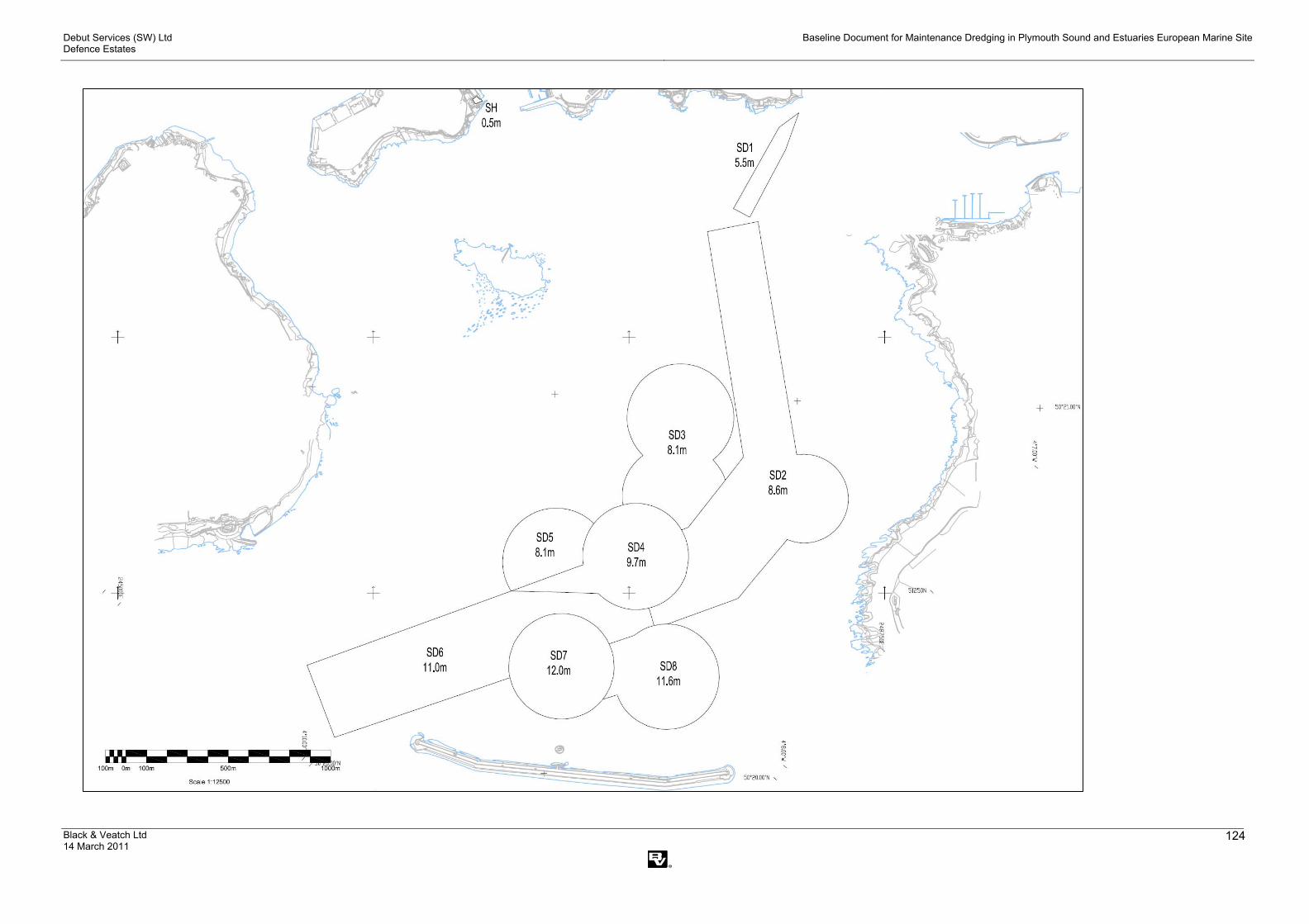
Debut Services (SW) Ltd Defence Estates
Baseline Document for Maintenance Dredging in Plymouth Sound and Estuaries European Marine Site
Black & Veatch Ltd 14 March 2011
124

Debut Services (SW) Ltd Defence Estates
Baseline Document for Maintenance Dredging in Plymouth Sound and Estuaries European Marine Site
Black & Veatch Ltd 14 March 2011
125
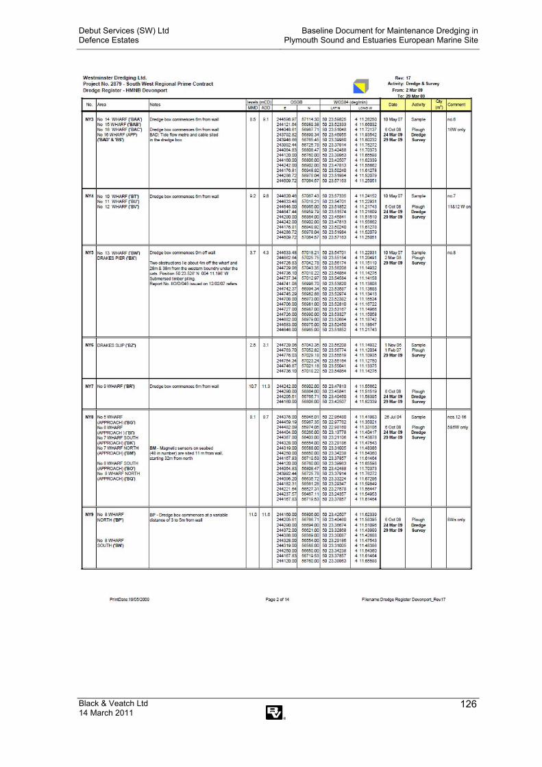
Debut Services (SW) Ltd Defence Estates
Baseline Document for Maintenance Dredging in Plymouth Sound and Estuaries European Marine Site
Black & Veatch Ltd 14 March 2011
126

Debut Services (SW) Ltd Defence Estates
Baseline Document for Maintenance Dredging in Plymouth Sound and Estuaries European Marine Site
Black & Veatch Ltd 14 March 2011
127

Debut Services (SW) Ltd Defence Estates
Baseline Document for Maintenance Dredging in Plymouth Sound and Estuaries European Marine Site
Black & Veatch Ltd 14 March 2011
128
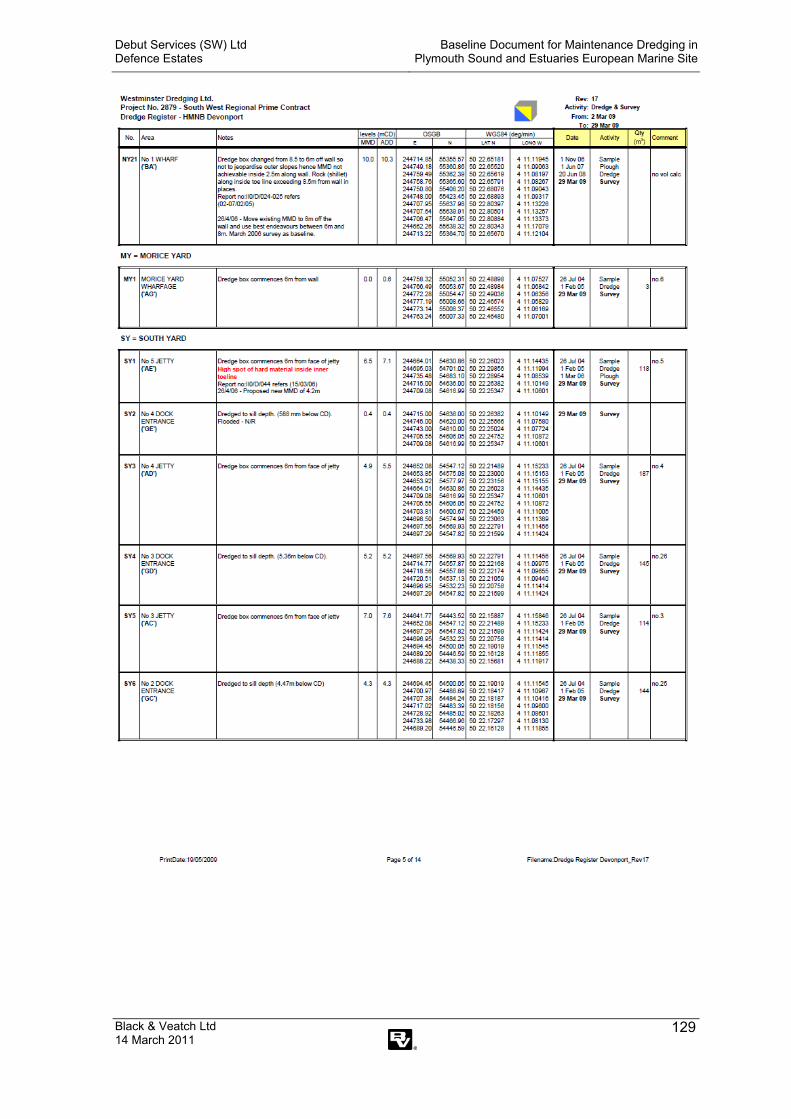
Debut Services (SW) Ltd Defence Estates
Baseline Document for Maintenance Dredging in Plymouth Sound and Estuaries European Marine Site
Black & Veatch Ltd 14 March 2011
129
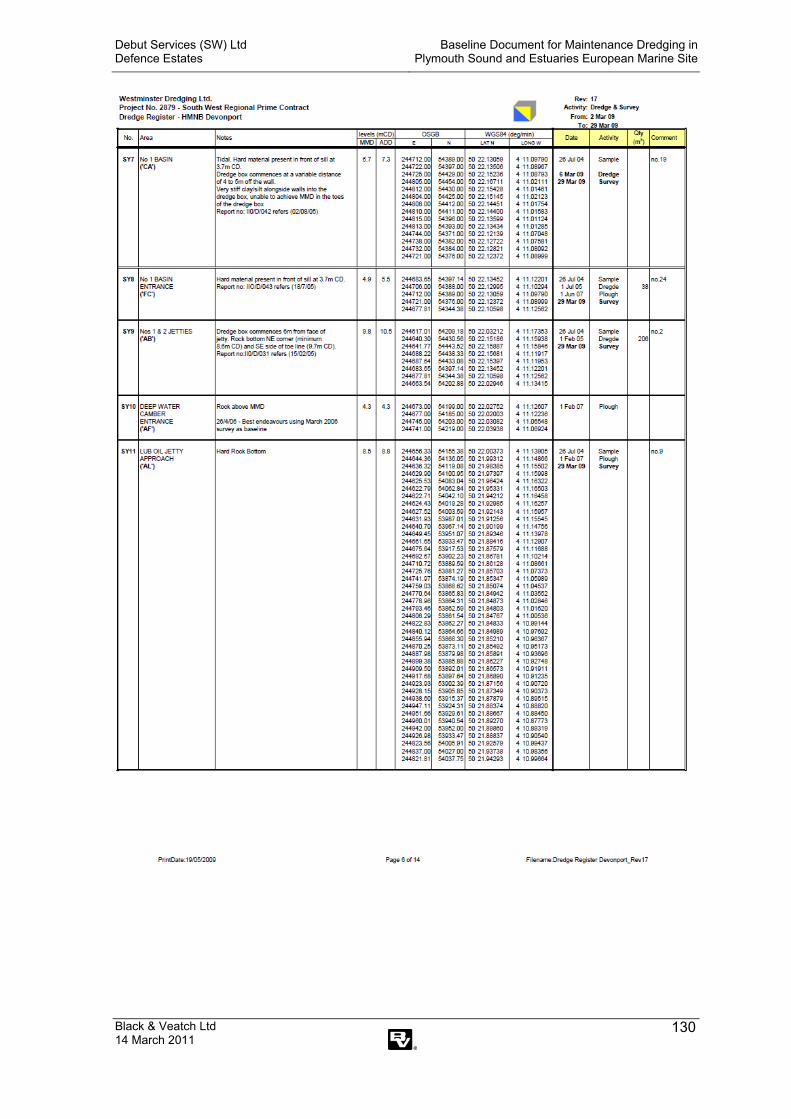
Debut Services (SW) Ltd Defence Estates
Baseline Document for Maintenance Dredging in Plymouth Sound and Estuaries European Marine Site
Black & Veatch Ltd 14 March 2011
130

Debut Services (SW) Ltd Defence Estates
Baseline Document for Maintenance Dredging in Plymouth Sound and Estuaries European Marine Site
Black & Veatch Ltd 14 March 2011
131

Debut Services (SW) Ltd Defence Estates
Baseline Document for Maintenance Dredging in Plymouth Sound and Estuaries European Marine Site
Black & Veatch Ltd 14 March 2011
132
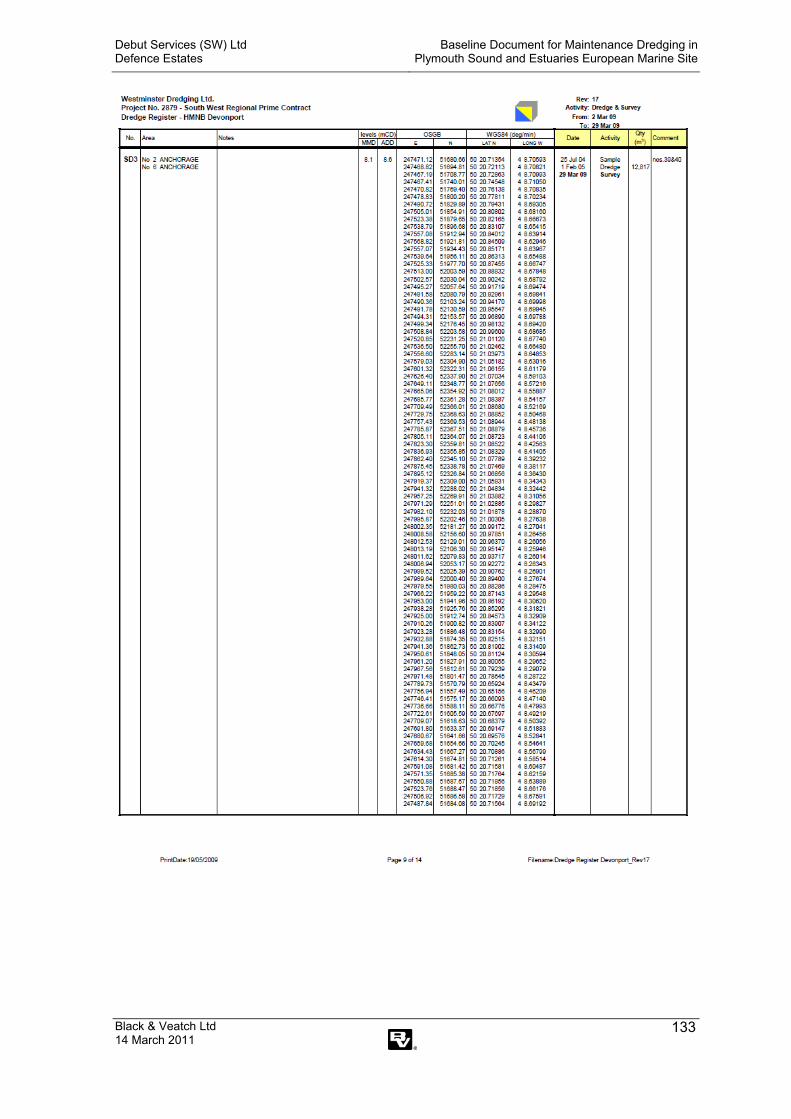
Debut Services (SW) Ltd Defence Estates
Baseline Document for Maintenance Dredging in Plymouth Sound and Estuaries European Marine Site
Black & Veatch Ltd 14 March 2011
133

Debut Services (SW) Ltd Defence Estates
Baseline Document for Maintenance Dredging in Plymouth Sound and Estuaries European Marine Site
Black & Veatch Ltd 14 March 2011
134

Debut Services (SW) Ltd Defence Estates
Baseline Document for Maintenance Dredging in Plymouth Sound and Estuaries European Marine Site
Black & Veatch Ltd 14 March 2011
135

Debut Services (SW) Ltd Defence Estates
Baseline Document for Maintenance Dredging in Plymouth Sound and Estuaries European Marine Site
Black & Veatch Ltd 14 March 2011
136
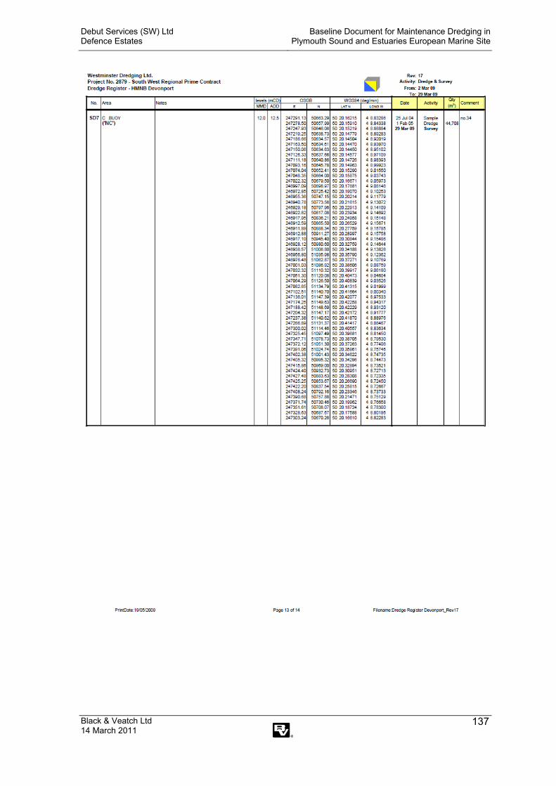
Debut Services (SW) Ltd Defence Estates
Baseline Document for Maintenance Dredging in Plymouth Sound and Estuaries European Marine Site
Black & Veatch Ltd 14 March 2011
137

Debut Services (SW) Ltd Defence Estates
Baseline Document for Maintenance Dredging in Plymouth Sound and Estuaries European Marine Site
Black & Veatch Ltd 14 March 2011
138

Debut Services (SW) Ltd Defence Estates
Baseline Document for Maintenance Dredging in Plymouth Sound and Estuaries European Marine Site
Black & Veatch Ltd 14 March 2011
139
Appendix XI – Disposal data as received from the Marine Management Organisation

Debut Services (SW) Ltd Defence Estates
Baseline Document for Maintenance Dredging in Plymouth Sound and Estuaries European Marine Site
Black & Veatch Ltd 14 March 2011
140
Rame Head Disposals 1985 to 1999Licence Id N/R/V Waste Id Licensee Where Start Date Expiry Date Total Qty Addtl Qty Site Code Year Dumped, t1875/84/0 RENEWAL MD Zanen Dredging& Contracting Co Ltd TAMAR RIVER ("H.M. NAVAL BASE,DEVON 23-Mar-84 22-Mar-85 300,000.00 PL030 1985 02329/85/0 NEW CD PVW International D & H Works Ltd DEVONPORT 11-Jan-85 10-Jan-86 74,500.00 PL030 1985 45,5422329/85/0 NEW CD PVW International D & H Works Ltd DEVONPORT 11-Jan-85 10-Jan-86 74,500.00 PL030 1986 02346/84/0 NEW MD Dredgework Services Ltd HMS Raleigh, Jupiter Point 20-Dec-84 19-Dec-85 5,100.00 PL030 1985 2,8732413/85/0 NEW MD The Ballast Pound Yacht Harbour Ltd The Ballast Pound Yacht Harbour Ltd 26-Jun-85 25-Jun-86 13,000.00 PL030 1985 8,8052413/85/0 NEW MD The Ballast Pound Yacht Harbour Ltd The Ballast Pound Yacht Harbour Ltd 26-Jun-85 25-Jun-86 13,000.00 PL030 1986 02413/88/0 RENEWAL CD The Ballast Pound Yacht Harbour Ltd The Ballast Pound Yacht Harbour Ltd 14-Jun-88 13-Jun-89 30,000.00 PL030 1988 02413/88/0 RENEWAL CD The Ballast Pound Yacht Harbour Ltd The Ballast Pound Yacht Harbour Ltd 14-Jun-88 13-Jun-89 30,000.00 PL030 1989 02428/85/0 NEW CD City of Plymouth TAMAR RIVER (PLYMOUTH MARINE EVENTS BASE 22-Oct-85 21-Oct-86 196,300.00 PL030 1985 12,2002428/85/0 NEW CD City of Plymouth TAMAR RIVER (PLYMOUTH MARINE EVENTS BASE 22-Oct-85 21-Oct-86 196,300.00 PL030 1986 108,5762468/85/0 NEW CD Associated British Ports TAMAR RIVER (MILLBAY DOCKS) 11-Sep-85 10-Sep-86 70,000.00 PL030 1985 23,3822468/85/0 NEW CD Associated British Ports TAMAR RIVER (MILLBAY DOCKS) 11-Sep-85 10-Sep-86 70,000.00 PL030 1986 02503/85/0 NEW CD Holland Dredging Co (UK) Ltd WESTON MILL JETTY, DEVONPORT 19-Nov-85 18-Nov-86 975,000.00 PL030 1985 80,9002503/85/0 NEW CD Holland Dredging Co (UK) Ltd WESTON MILL JETTY, DEVONPORT 19-Nov-85 18-Nov-86 975,000.00 PL030 1986 904,6002503/87/0 RENEWAL CD Costain Civil Engineering Ltd WESTON MILL JETTY, DEVONPORT 19-Jan-87 23-Jun-87 8,450.00 PL030 1987 4,8002503/87/1 VARIATION CD Costain Civil Engineering Ltd WESTON MILL JETTY, DEVONPORT 24-Jun-87 06-Jul-87 48,900.00 40,450.00 PL030 1987 4502503/87/2 VARIATION CD Costain Civil Engineering Ltd WESTON MILL JETTY, DEVONPORT 07-Jul-87 10-Nov-87 48,900.00 0 PL030 1987 37,7902503/87/3 VARIATION CD Costain Civil Engineering Ltd WESTON MILL JETTY, DEVONPORT 11-Nov-87 18-Jan-88 48,900.00 0 PL030 1987 6002503/87/3 VARIATION CD Costain Civil Engineering Ltd WESTON MILL JETTY, DEVONPORT 11-Nov-87 18-Jan-88 48,900.00 0 PL030 1988 02503/88/0 RENEWAL CD Costain Civil Engineering Ltd WESTON MILL JETTY, DEVONPORT 19-Jan-88 17-Jan-89 27,800.00 PL030 1988 7,2002503/88/0 RENEWAL CD Costain Civil Engineering Ltd WESTON MILL JETTY, DEVONPORT 19-Jan-88 17-Jan-89 27,800.00 PL030 1989 02698/86/0 NEW CD Shoreline Engineering Ltd DEVONPORT 01-Aug-86 31-Jul-87 2,600.00 PL030 1986 2,1502698/86/0 NEW CD Shoreline Engineering Ltd DEVONPORT 01-Aug-86 31-Jul-87 2,600.00 PL030 1987 02917/87/0 NEW MD Dredgework Services Ltd DEVONPORT 01-Jul-87 29-Jun-88 38,000.00 PL030 1987 1,9242917/87/0 NEW MD Dredgework Services Ltd DEVONPORT 01-Jul-87 29-Jun-88 38,000.00 PL030 1988 02958/87/0 NEW CD Sailport Plc MAYFLOWER INTERNATIONAL MARINA 19-Dec-87 17-Dec-88 9,000.00 PL030 1987 02958/87/0 NEW CD Sailport Plc MAYFLOWER INTERNATIONAL MARINA 19-Dec-87 17-Dec-88 9,000.00 PL030 1988 02958/89/0 RENEWAL CD Sailport Plc MAYFLOWER INTERNATIONAL MARINA 27-Feb-89 26-Feb-90 9,000.00 PL030 1989 02958/89/0 RENEWAL CD Sailport Plc MAYFLOWER INTERNATIONAL MARINA 27-Feb-89 26-Feb-90 9,000.00 PL030 1990 02958/90/0 RENEWAL CD Sailport Plc MAYFLOWER INTERNATIONAL MARINA 27-Feb-90 26-Feb-91 9,000.00 PL030 1990 02958/90/0 RENEWAL CD Sailport Plc MAYFLOWER INTERNATIONAL MARINA 27-Feb-90 26-Feb-91 9,000.00 PL030 1991 03023/87/0 NEW MD Nash Dredging Ltd DEVONPORT 24-Nov-87 07-Dec-87 260,000.00 PL030 1987 03023/87/1 VARIATION MD Nash Dredging Ltd DEVONPORT 08-Dec-87 22-Nov-88 260,000.00 0 PL030 1987 25,8193023/87/1 VARIATION MD Nash Dredging Ltd DEVONPORT 08-Dec-87 22-Nov-88 260,000.00 0 PL030 1988 227,5803033/87/0 NEW MD Dredging Marine (South West) Ltd SOUTH DOWN QUAY, MILLBROOK 01-Jan-88 30-Dec-88 60,000.00 PL030 1988 10,3653033/89/0 RENEWAL MD Dredging Marine (South West) Ltd SOUTH DOWN QUAY, MILLBROOK 02-Aug-89 01-Aug-90 60,000.00 PL030 1989 03033/89/0 RENEWAL MD Dredging Marine (South West) Ltd SOUTH DOWN QUAY, MILLBROOK 02-Aug-89 01-Aug-90 60,000.00 PL030 1990 03033/92/0 RENEWAL MD Seaward Marine Enterprises SOUTH DOWN QUAY, MILLBROOK 18-Mar-92 17-Mar-93 9,000.00 PL030 1992 3,2403033/92/0 RENEWAL MD Seaward Marine Enterprises SOUTH DOWN QUAY, MILLBROOK 18-Mar-92 17-Mar-93 9,000.00 PL030 1993 0
30522/99/0 RENEWAL MD Cattewater Harbour Commissioners CATTEWATER HARBOUR 17-Mar-99 08-Jul-99 49,950.00 PL031 1999 030522/99/1 VARIATION MD Cattewater Harbour Commissioners CATTEWATER HARBOUR 08-Jul-99 09-Jul-99 49,950.00 0 PL031 1999 030522/99/2 VARIATION MD Cattewater Harbour Commissioners CATTEWATER HARBOUR 09-Jul-99 16-Mar-00 49,950.00 0 PL031 1999 12,84630711/99/0 NEW CD Stride Management Ltd DEVONPORT 25-Oct-99 17-Nov-99 80,000.00 PL031 1999 030711/99/1 VARIATION CD Stride Management Ltd DEVONPORT 17-Nov-99 22-Nov-99 80,000.00 0 PL031 1999 030711/99/2 VARIATION CD Stride Management Ltd DEVONPORT 22-Nov-99 19-Jun-00 78,000.00 0 PL031 1999 51,185
3159/88/0 NEW CD Dean And Dyball Shipping Ltd MILLBAY DOCKS 22-Jun-88 21-Jun-89 27,000.00 PL030 1988 1,9503159/88/0 NEW CD Dean And Dyball Shipping Ltd MILLBAY DOCKS 22-Jun-88 21-Jun-89 27,000.00 PL030 1989 03159/89/0 RENEWAL CD Dean And Dyball Shipping Ltd MILLBAY DOCKS 22-Jun-89 21-Jun-90 60,000.00 PL030 1989 03159/89/0 RENEWAL CD Dean And Dyball Shipping Ltd MILLBAY DOCKS 22-Jun-89 21-Jun-90 60,000.00 PL030 1990 03326/89/0 NEW CD Holland Dredging Co (UK) Ltd DEVONPORT 14-Feb-89 13-Feb-90 110,000.00 PL030 1989 109,0003326/89/0 NEW CD Holland Dredging Co (UK) Ltd DEVONPORT 14-Feb-89 13-Feb-90 110,000.00 PL030 1990 03326/90/0 RENEWAL MD Holland Dredging Co (UK) Ltd DEVONPORT 14-Feb-90 13-Feb-91 250,000.00 PL030 1990 205,0003326/90/0 RENEWAL MD Holland Dredging Co (UK) Ltd DEVONPORT 14-Feb-90 13-Feb-91 250,000.00 PL030 1991 03326/92/0 RENEWAL MD Works & Engineering Services Dept DEVONPORT 01-Oct-92 30-Sep-93 91,000.00 PL030 1992 66,3003326/92/0 RENEWAL MD Works & Engineering Services Dept DEVONPORT 01-Oct-92 30-Sep-93 91,000.00 PL030 1993 03326/95/0 RENEWAL MD W S Atkins Consultants DEVONPORT 25-Sep-95 10-Oct-95 380,000.00 PL031 1995 36,2543326/95/1 VARIATION MD W S Atkins Consultants DEVONPORT 11-Oct-95 24-Sep-96 0 PL031 1995 156,3453326/95/1 VARIATION MD W S Atkins Consultants DEVONPORT 11-Oct-95 24-Sep-96 0 PL031 1996 03334/89/0 NEW CD Edmund Nuttall Ltd DEVONPORT 27-Feb-89 26-Feb-90 5,500.00 PL030 1989 3,7003334/89/0 NEW CD Edmund Nuttall Ltd DEVONPORT 27-Feb-89 26-Feb-90 5,500.00 PL030 1990 0

Debut Services (SW) Ltd Defence Estates
Baseline Document for Maintenance Dredging in Plymouth Sound and Estuaries European Marine Site
Black & Veatch Ltd 14 March 2011
141
Rame Head Disposals 1985 to 1999Licence Id N/R/V Waste Id Licensee Where Start Date Expiry Date Total Qty Addtl Qty Site Code Year Dumped, t3382/89/0 NEW MD Holland Dredging Co (UK) Ltd DEVONPORT 13-May-89 12-May-90 30,000.00 PL030 1989 29,0003382/89/0 NEW MD Holland Dredging Co (UK) Ltd DEVONPORT 13-May-89 12-May-90 30,000.00 PL030 1990 03457/89/0 NEW MD Nash Dredging Ltd DEVONPORT 18-Aug-89 17-Aug-90 70,000.00 PL030 1989 40,9703457/89/0 NEW MD Nash Dredging Ltd DEVONPORT 18-Aug-89 17-Aug-90 70,000.00 PL030 1990 03549/90/0 NEW MD Holland Dredging Co (UK) Ltd DEVONPORT 26-Feb-90 25-Feb-91 45,000.00 PL030 1990 44,9003549/90/0 NEW MD Holland Dredging Co (UK) Ltd DEVONPORT 26-Feb-90 25-Feb-91 45,000.00 PL030 1991 0
376/83/0 RENEWAL CD Sutton Harbour Company SUTTON HARBOUR 01-Feb-83 06-Feb-85 105,000.00 PL030 1985 1,360376/85/0 VARIATION CD Sutton Harbour Company SUTTON HARBOUR 07-Feb-85 31-Jan-86 35,000.00 0 PL030 1985 8,080376/85/0 VARIATION CD Sutton Harbour Company SUTTON HARBOUR 07-Feb-85 31-Jan-86 35,000.00 0 PL030 1986 0376/86/0 RENEWAL MD Sutton Harbour Company SUTTON HARBOUR 22-Mar-86 21-Mar-87 13,000.00 PL030 1986 5,580376/86/0 RENEWAL MD Sutton Harbour Company SUTTON HARBOUR 22-Mar-86 21-Mar-87 13,000.00 PL030 1987 0376/87/0 RENEWAL MD Sutton Harbour Company SUTTON HARBOUR 22-Mar-87 21-Mar-88 13,000.00 PL030 1987 0376/87/0 RENEWAL MD Sutton Harbour Company SUTTON HARBOUR 22-Mar-87 21-Mar-88 13,000.00 PL030 1988 0376/88/0 RENEWAL MD Sutton Harbour Company SUTTON HARBOUR 22-Mar-88 21-Mar-89 15,000.00 PL030 1988 2,460376/88/0 RENEWAL MD Sutton Harbour Company SUTTON HARBOUR 22-Mar-88 21-Mar-89 15,000.00 PL030 1989 0376/89/0 RENEWAL MD Sutton Harbour Company SUTTON HARBOUR 22-Mar-89 21-Mar-90 50,000.00 PL030 1989 5,950376/89/0 RENEWAL MD Sutton Harbour Company SUTTON HARBOUR 22-Mar-89 21-Mar-90 50,000.00 PL030 1990 0376/90/0 RENEWAL MD Sutton Harbour Company SUTTON HARBOUR 22-Mar-90 21-Mar-91 20,000.00 PL030 1990 0376/90/0 RENEWAL MD Sutton Harbour Company SUTTON HARBOUR 22-Mar-90 21-Mar-91 20,000.00 PL030 1991 0376/92/0 RENEWAL MD Sutton Harbour Company SUTTON HARBOUR 14-Oct-92 13-Oct-93 20,000.00 PL030 1992 0376/92/0 RENEWAL MD Sutton Harbour Company SUTTON HARBOUR 14-Oct-92 13-Oct-93 20,000.00 PL030 1993 0398/86/0 RENEWAL MD Cattewater Harbour Commissioners CATTEWATER HARBOUR 31-Jan-86 30-Jan-87 30,000.00 PL030 1986 0398/86/0 RENEWAL MD Cattewater Harbour Commissioners CATTEWATER HARBOUR 31-Jan-86 30-Jan-87 30,000.00 PL030 1987 0398/87/0 RENEWAL CD Cattewater Harbour Commissioners CATTEWATER HARBOUR 01-Jan-88 16-Feb-88 39,650.00 PL030 1988 42,123398/88/0 VARIATION CD Cattewater Harbour Commissioners CATTEWATER HARBOUR 17-Feb-88 30-Dec-88 48,425.00 8,775.00 PL030 1988 0398/95/0 RENEWAL MD Cattewater Harbour Commissioners CATTEWATER HARBOUR 26-Jan-95 25-Jan-96 77,000.00 PL031 1995 19,387398/95/0 RENEWAL MD Cattewater Harbour Commissioners CATTEWATER HARBOUR 26-Jan-95 25-Jan-96 77,000.00 PL031 1996 0402/82/0 RENEWAL MD Associated British Ports MILLBAY DOCKS 01-Jul-82 30-Jun-85 60,000.00 PL030 1985 0402/85/0 RENEWAL MD Associated British Ports MILLBAY DOCKS 26-Jul-85 21-Aug-85 30,000.00 PL030 1985 0402/85/1 VARIATION MD Associated British Ports MILLBAY DOCKS 22-Aug-85 25-Jul-88 90,000.00 60,000.00 PL030 1985 8,080402/85/1 VARIATION MD Associated British Ports MILLBAY DOCKS 22-Aug-85 25-Jul-88 90,000.00 60,000.00 PL030 1986 0402/85/1 VARIATION MD Associated British Ports MILLBAY DOCKS 22-Aug-85 25-Jul-88 90,000.00 60,000.00 PL030 1987 1,578402/85/1 VARIATION MD Associated British Ports MILLBAY DOCKS 22-Aug-85 25-Jul-88 90,000.00 60,000.00 PL030 1988 0
4259/93/0 NEW MD Scott Wilson Kirkpatrick DEVONPORT 18-Sep-93 17-Sep-94 50,000.00 PL030 1993 67,2004259/93/0 NEW MD Scott Wilson Kirkpatrick DEVONPORT 18-Sep-93 17-Sep-94 50,000.00 PL030 1994 44,9794260/93/0 NEW MD Scott Wilson Kirkpatrick DEVONPORT 11-Nov-93 10-Nov-94 10,000.00 PL030 1993 25,6004260/93/0 NEW MD Scott Wilson Kirkpatrick DEVONPORT 11-Nov-93 10-Nov-94 10,000.00 PL030 1994 10,5664268/93/0 NEW CD PLYMOUTH CITY COUNCIL,ENGINEERING SERVICE SECTION CATTEDOWN RECLAMATION 12-Oct-93 11-Oct-94 187,000.00 PL030 1993 04268/93/0 NEW CD PLYMOUTH CITY COUNCIL,ENGINEERING SERVICE SECTION CATTEDOWN RECLAMATION 12-Oct-93 11-Oct-94 187,000.00 PL030 1994 04268/95/0 RENEWAL CD PLYMOUTH CITY COUNCIL,ENGINEERING SERVICE SECTION CATTEDOWN RECLAMATION 03-Apr-95 02-Apr-96 187,000.00 PL030 1995 04268/95/0 RENEWAL CD PLYMOUTH CITY COUNCIL,ENGINEERING SERVICE SECTION CATTEDOWN RECLAMATION 03-Apr-95 02-Apr-96 187,000.00 PL030 1996 04387/94/0 NEW CD South West Water Services Ltd FOWEY 11-Mar-94 19-Oct-94 4,400.00 PL030 1994 04415/94/0 NEW MD Scott Wilson Kirkpatrick DEVONPORT 25-Jul-94 15-Sep-94 87,000.00 PL030 1994 04415/94/1 VARIATION MD Scott Wilson Kirkpatrick DEVONPORT 19-Sep-94 02-Oct-94 87,000.00 0 PL030 1994 7,2004415/94/2 VARIATION MD Scott Wilson Kirkpatrick DEVONPORT 04-Oct-94 24-Jul-95 112,000.00 25,000.00 PL030 1994 100,8004415/94/2 VARIATION MD Scott Wilson Kirkpatrick DEVONPORT 04-Oct-94 24-Jul-95 112,000.00 25,000.00 PL030 1995 04524/94/0 NEW MD Base Services Department PLYMOUTH SOUND CHANNELS 03-Nov-94 14-Dec-94 792,000.00 PL030 1994 315,1064524/94/1 VARIATION MD Base Services Department PLYMOUTH SOUND CHANNELS 15-Dec-94 17-May-95 1,000,500.00 208,500.00 PL031 1994 126,0584524/94/1 VARIATION MD Base Services Department PLYMOUTH SOUND CHANNELS 15-Dec-94 17-May-95 1,000,500.00 208,500.00 PL031 1995 266,9904524/95/0 VARIATION MD Base Services Department PLYMOUTH SOUND CHANNELS 18-May-95 02-Nov-95 792,000.00 0 PL031 1995 04794/95/0 NEW MD Associated British Ports MILLBAY DOCKS 26-Oct-95 25-Oct-96 22,400.00 PL030 1995 2,9404794/95/0 NEW MD Associated British Ports MILLBAY DOCKS 26-Oct-95 25-Oct-96 22,400.00 PL030 1996 05040/96/0 NEW CD Maunsell LRDC Ltd CLOVELLY BAY, CATTEWATER 21-Oct-96 20-Oct-97 96,000.00 PL031 1996 05040/96/0 NEW CD Maunsell LRDC Ltd CLOVELLY BAY, CATTEWATER 21-Oct-96 20-Oct-97 96,000.00 PL031 1997 63,0005040/97/0 RENEWAL CD Maunsell Maritime CLOVELLY BAY, CATTEWATER 21-Oct-97 20-Oct-98 96,000.00 PL031 1997 36,9605040/97/0 RENEWAL CD Maunsell Maritime CLOVELLY BAY, CATTEWATER 21-Oct-97 20-Oct-98 96,000.00 PL031 1998 46,7605081/96/0 NEW CD DEFENCE ESTATES C/O MINISTRY OF DEFENCE DEVONPORT 15-Oct-96 14-Oct-97 80,000.00 PL031 1996 13,1255081/96/0 NEW CD DEFENCE ESTATES C/O MINISTRY OF DEFENCE DEVONPORT 15-Oct-96 14-Oct-97 80,000.00 PL031 1997 64,164
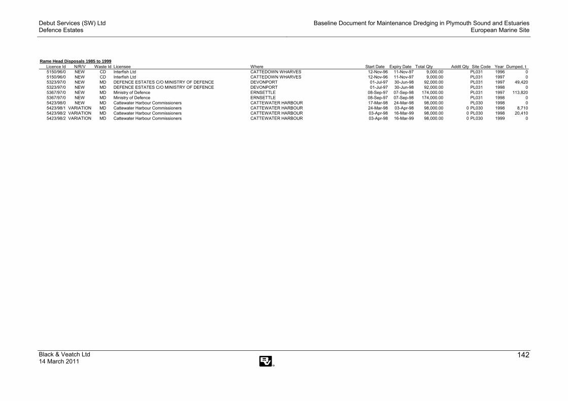
Debut Services (SW) Ltd Defence Estates
Baseline Document for Maintenance Dredging in Plymouth Sound and Estuaries European Marine Site
Black & Veatch Ltd 14 March 2011
142
Rame Head Disposals 1985 to 1999Licence Id N/R/V Waste Id Licensee Where Start Date Expiry Date Total Qty Addtl Qty Site Code Year Dumped, t5150/96/0 NEW CD Interfish Ltd CATTEDOWN WHARVES 12-Nov-96 11-Nov-97 9,000.00 PL031 1996 05150/96/0 NEW CD Interfish Ltd CATTEDOWN WHARVES 12-Nov-96 11-Nov-97 9,000.00 PL031 1997 05323/97/0 NEW MD DEFENCE ESTATES C/O MINISTRY OF DEFENCE DEVONPORT 01-Jul-97 30-Jun-98 92,000.00 PL031 1997 49,4205323/97/0 NEW MD DEFENCE ESTATES C/O MINISTRY OF DEFENCE DEVONPORT 01-Jul-97 30-Jun-98 92,000.00 PL031 1998 05367/97/0 NEW MD Ministry of Defence ERNSETTLE 08-Sep-97 07-Sep-98 174,000.00 PL031 1997 113,8205367/97/0 NEW MD Ministry of Defence ERNSETTLE 08-Sep-97 07-Sep-98 174,000.00 PL031 1998 05423/98/0 NEW MD Cattewater Harbour Commissioners CATTEWATER HARBOUR 17-Mar-98 24-Mar-98 98,000.00 PL030 1998 05423/98/1 VARIATION MD Cattewater Harbour Commissioners CATTEWATER HARBOUR 24-Mar-98 03-Apr-98 98,000.00 0 PL030 1998 8,7105423/98/2 VARIATION MD Cattewater Harbour Commissioners CATTEWATER HARBOUR 03-Apr-98 16-Mar-99 98,000.00 0 PL030 1998 20,4105423/98/2 VARIATION MD Cattewater Harbour Commissioners CATTEWATER HARBOUR 03-Apr-98 16-Mar-99 98,000.00 0 PL030 1999 0

Debut Services (SW) Ltd Defence Estates
Baseline Document for Maintenance Dredging in Plymouth Sound and Estuaries European Marine Site
Black & Veatch Ltd 14 March 2011
143
Rame Head Disposals 2000 to 2009Licence Id N/R/V Waste Id Licensee Start Date Expiry Date Total Qty Addtl Qty Site Code Year Dumped, t
30425/00/0 N CD JACOBS BABTIE (EXETER) RAFT NAVAL BASE 05‐Dec‐00 05‐Dec‐00 500,000 PL031 2000 030425/00/1 V CD JACOBS BABTIE (EXETER) RAFT NAVAL BASE 05‐Dec‐00 05‐Dec‐00 500,000 0 PL031 2000 030425/00/2 V CD JACOBS BABTIE (EXETER) RAFT NAVAL BASE 05‐Dec‐00 06‐Feb‐01 500,000 0 PL031 2000 108,43630425/00/2 V CD JACOBS BABTIE (EXETER) RAFT NAVAL BASE 05‐Dec‐00 06‐Feb‐01 500,000 0 PL031 2001 176,57730425/01/0 V CD JACOBS BABTIE (EXETER) RAFT NAVAL BASE 07‐Feb‐01 07‐Feb‐01 391,564 PL031 2001 148,29730425/01/1 V CD JACOBS BABTIE (EXETER) RAFT NAVAL BASE 07‐Feb‐01 30‐Nov‐01 243,267 0 PL031 2001 183,535
616,84530522/99/2 V MD Cattewater Harbour Commissioners 09‐Jul‐99 16‐Mar‐00 49,950 0 PL031 1999 12,84630522/99/2 V MD Cattewater Harbour Commissioners 09‐Jul‐99 16‐Mar‐00 49,950 0 PL031 2000 0
30711/00/0 V CD Stride Management Ltd H.M NAVAL BASE DEVONPORT 19‐Jun‐00 24‐Oct‐00 26,815 PL031 2000 6,42330711/99/2 V CD Stride Management Ltd H.M NAVAL BASE DEVONPORT 22‐Nov‐99 19‐Jun‐00 78,000 0 PL031 1999 51,18530711/99/2 V CD Stride Management Ltd H.M NAVAL BASE DEVONPORT 22‐Nov‐99 19‐Jun‐00 78,000 0 PL031 2000 0
30820/00/0 N MD Marina Developments Ltd QUEEN ANNE'S BATTERY MARINA, TAMAR 15‐Mar‐00 14‐Mar‐01 9,500 PL031 2000 030820/00/0 N MD Marina Developments Ltd QUEEN ANNE'S BATTERY MARINA, TAMAR 15‐Mar‐00 14‐Mar‐01 9,500 PL031 2001 0
30900/00/0 N MD Samos Ltd CARBEILE MILL, TORPOINT, PLYMOUTH 18‐Sep‐00 17‐Sep‐01 6,000 PL030 2000 030900/00/0 N MD Samos Ltd CARBEILE MILL, TORPOINT, PLYMOUTH 18‐Sep‐00 17‐Sep‐01 6,000 PL030 2001 0
31023/00/0 R MD Cattewater Harbour Commissioners 03‐Apr‐00 02‐Apr‐01 49,950 PL031 2000 031023/00/0 R MD Cattewater Harbour Commissioners 03‐Apr‐00 02‐Apr‐01 49,950 PL031 2001 26,87531023/01/0 R MD Cattewater Harbour Commissioners 26‐Apr‐01 25‐Apr‐02 49,999 PL031 2001 031023/01/0 R MD Cattewater Harbour Commissioners 26‐Apr‐01 25‐Apr‐02 49,999 PL031 2002 0
31161/01/0 N MD Base Services Department H.M NAVAL BASE DEVONPORT 30‐Jan‐01 19‐Feb‐01 210,090 PL031 2001 139,05031161/01/1 V MD Base Services Department H.M NAVAL BASE DEVONPORT 19‐Feb‐01 26‐Feb‐01 334,000 PL031 2001 56,08831161/01/2 V MD Base Services Department H.M NAVAL BASE DEVONPORT 26‐Feb‐01 02‐Mar‐01 281,000 7,000 PL031 2001 30,97531161/01/3 V MD Base Services Department H.M NAVAL BASE DEVONPORT 02‐Mar‐01 13‐Jun‐01 252,700 0 PL031 2001 104,33831161/01/3 V MD Base Services Department H.M NAVAL BASE DEVONPORT 02‐Mar‐01 13‐Jun‐01 252,700 0 PL031 2002 031161/01/4 V MD Base Services Department H.M NAVAL BASE DEVONPORT 13‐Jun‐01 08‐Aug‐01 148,362 0 PL031 2001 32,16231161/01/5 V MD Base Services Department H.M NAVAL BASE DEVONPORT 08‐Aug‐01 29‐Jan‐02 136,362 PL031 2001 2,34031161/01/5 V MD Base Services Department H.M NAVAL BASE DEVONPORT 08‐Aug‐01 29‐Jan‐02 136,362 PL031 2002 0
31381/01/0 N MD JACOBS BABTIE (EXETER) H.M NAVAL BASE DEVONPORT 01‐Nov‐01 31‐Oct‐02 212,970 PL031 2001 194,83431381/01/0 N MD JACOBS BABTIE (EXETER) H.M NAVAL BASE DEVONPORT 01‐Nov‐01 31‐Oct‐02 212,970 PL031 2002 0
31635/02/0 R MD Cattewater Harbour Commissioners 17‐Jun‐02 19‐Jul‐02 49,999 PL031 2002 5,99231635/02/1 V MD Cattewater Harbour Commissioners 19‐Jul‐02 14‐Feb‐03 49,999 0 PL031 2002 5,99231635/02/1 V MD Cattewater Harbour Commissioners 19‐Jul‐02 14‐Feb‐03 49,999 0 PL031 2003 6,69031635/03/0 V MD Cattewater Harbour Commissioners 14‐Feb‐03 09‐Jul‐03 44,007 PL031 2003 16,72531635/03/1 V MD Cattewater Harbour Commissioners 09‐Jul‐03 09‐Oct‐03 21,290 0 PL031 2003 0

Debut Services (SW) Ltd Defence Estates
Baseline Document for Maintenance Dredging in Plymouth Sound and Estuaries European Marine Site
Black & Veatch Ltd 14 March 2011
144
Rame Head Disposals 2000 to 2009Licence Id N/R/V Waste Id Licensee Start Date Expiry Date Total Qty Addtl Qty Site Code Year Dumped, t
31831/02/0 N MD Royal National Lifeboat Institution SALCOMBE FAIRWAY, BATSON CREEK 20‐Dec‐02 12‐Feb‐03 45,325 PL031 2002 031831/02/0 N MD Royal National Lifeboat Institution SALCOMBE FAIRWAY, BATSON CREEK 20‐Dec‐02 12‐Feb‐03 45,325 PL031 2003 50831831/03/0 V MD Royal National Lifeboat Institution SALCOMBE FAIRWAY, BATSON CREEK 12‐Feb‐03 25‐Apr‐03 45,325 0 PL031 2003 34,93831831/03/1 V MD Royal National Lifeboat Institution SALCOMBE FAIRWAY, BATSON CREEK 25‐Apr‐03 12‐Apr‐04 10,387 PL031 2003 35,410
31868/05/0 N CD WINTERS MARINE LTD LINCOMBE MARINA ACCESS CHANNEL 01‐Sep‐05 22‐Sep‐05 10,800 PL031 2005 031868/05/1 V CD WINTERS MARINE LTD LINCOMBE MARINA ACCESS CHANNEL 22‐Sep‐05 31‐Aug‐06 10,800 0 PL031 2005 031868/05/1 V CD WINTERS MARINE LTD LINCOMBE MARINA ACCESS CHANNEL 22‐Sep‐05 31‐Aug‐06 10,800 0 PL031 2006 0
31958/03/0 N CD Associated British Ports Millbay Docks 14‐Nov‐03 09‐Dec‐03 66,320 PL031 2003 031958/03/1 V CD Associated British Ports Millbay Docks 09‐Dec‐03 19‐Jun‐04 66,320 0 PL031 2003 931958/03/1 V CD Associated British Ports Millbay Docks 09‐Dec‐03 19‐Jun‐04 66,320 0 PL031 2004 59,08031958/04/0 V CD Associated British Ports Millbay Docks 19‐Jun‐04 13‐Nov‐04 36,320 30,000 PL031 2004 34,720
32032/03/0 N MD DEFENCE ESTATES C/O MINISTRY OF DEFENH.M NAVAL BASE DEVONPORT 04‐Sep‐03 15‐Oct‐03 68,070 PL031 2003 032032/03/1 V MD DEFENCE ESTATES C/O MINISTRY OF DEFENH.M NAVAL BASE DEVONPORT 15‐Oct‐03 18‐Feb‐04 276,855 208,785 PL031 2003 032032/03/1 V MD DEFENCE ESTATES C/O MINISTRY OF DEFENH.M NAVAL BASE DEVONPORT 15‐Oct‐03 18‐Feb‐04 276,855 208,785 PL031 2004 032032/04/0 V MD DEFENCE ESTATES C/O MINISTRY OF DEFENH.M NAVAL BASE DEVONPORT 20‐Feb‐04 03‐Sep‐04 130,250 PL031 2004 39,513
32243/03/0 R MD Cattewater Harbour Commissioners 28‐Oct‐03 27‐Oct‐04 49,999 PL031 2003 032243/03/0 R MD Cattewater Harbour Commissioners 28‐Oct‐03 27‐Oct‐04 49,999 PL031 2004 0
32323/04/0 N MD Defence Estates H.M NAVAL BASE DEVONPORT 18‐Feb‐04 03‐Jun‐04 120,000 PL031 2004 69,64732323/04/1 V MD Defence Estates H.M NAVAL BASE DEVONPORT 03‐Jun‐04 26‐Aug‐04 50,353 PL031 2004 032323/04/2 V MD ROYAL BOSKALIS WESTMINSTER DREDGIN H.M NAVAL BASE DEVONPORT 26‐Aug‐04 17‐Feb‐05 50,353 0 PL031 2004 38,74432323/04/2 V MD ROYAL BOSKALIS WESTMINSTER DREDGIN H.M NAVAL BASE DEVONPORT 26‐Aug‐04 17‐Feb‐05 50,353 0 PL031 2005 20,118
32433/04/0 N MD ROYAL BOSKALIS WESTMINSTER DREDGIN H.M NAVAL BASE DEVONPORT 01‐Jan‐05 23‐Mar‐05 647,154 PL031 2005 114,54432433/05/0 V MD ROYAL BOSKALIS WESTMINSTER DREDGIN H.M NAVAL BASE DEVONPORT 23‐Mar‐05 11‐Jul‐05 101,174 PL031 2005 032433/05/1 V MD ROYAL BOSKALIS WESTMINSTER DREDGIN H.M NAVAL BASE DEVONPORT 11‐Jul‐05 10‐Feb‐06 101,174 0 PL031 2005 5,65932433/05/1 V MD ROYAL BOSKALIS WESTMINSTER DREDGIN H.M NAVAL BASE DEVONPORT 11‐Jul‐05 10‐Feb‐06 101,174 0 PL031 2006 032433/06/0 V MD ROYAL BOSKALIS WESTMINSTER DREDGIN H.M NAVAL BASE DEVONPORT 10‐Feb‐06 19‐Jul‐06 95,515 0 PL031 2006 032433/06/1 V MD ROYAL BOSKALIS WESTMINSTER DREDGIN H.M NAVAL BASE DEVONPORT 19‐Jul‐06 31‐Dec‐07 95,515 0 PL031 2006 032433/06/1 V MD ROYAL BOSKALIS WESTMINSTER DREDGIN H.M NAVAL BASE DEVONPORT 19‐Jul‐06 31‐Dec‐07 95,515 0 PL031 2007 86,958
33271/06/0 N MD Cattewater Harbour Commissioners 28‐Jul‐06 23‐Dec‐06 19,500 PL031 2006 033271/06/1 V MD Cattewater Harbour Commissioners 23‐Dec‐06 18‐Jun‐07 19,500 PL031 2006 033271/06/1 V MD Cattewater Harbour Commissioners 23‐Dec‐06 18‐Jun‐07 19,500 PL031 2007 10,72533271/07/0 V MD Cattewater Harbour Commissioners 18‐Jun‐07 27‐Jul‐07 8,775 0 PL031 2007 1,200
33664/07/0 R MD ROYAL BOSKALIS WESTMINSTER DREDGIN H.M NAVAL BASE DEVONPORT 09‐Jan‐08 02‐Feb‐09 352,000 PL031 2008 24,53833664/07/0 R MD ROYAL BOSKALIS WESTMINSTER DREDGIN H.M NAVAL BASE DEVONPORT 09‐Jan‐08 02‐Feb‐09 352,000 PL031 2009 033664/09/0 V MD ROYAL BOSKALIS WESTMINSTER DREDGIN H.M NAVAL BASE DEVONPORT 05‐Feb‐09 05‐Mar‐10 234,666 PL031 2009 34,59833664/09/0 V MD ROYAL BOSKALIS WESTMINSTER DREDGIN H.M NAVAL BASE DEVONPORT 05‐Feb‐09 05‐Mar‐10 234,666 PL031 2010 0
34315/09/0 N MD Marina Developments Limited QUEEN ANNE'S BATTERY MARINA 18‐May‐09 01‐Sep‐09 29,700 PL031 2009 034315/09/1 V MD Marina Developments Limited QUEEN ANNE'S BATTERY MARINA 01‐Sep‐09 17‐May‐12 29,700 0 PL031 2009 4,000
Debut Services (SW) Ltd Defence Estates
Baseline Document for Maintenance Dredging in Plymouth Sound and Estuaries European Marine Site
Black & Veatch Ltd 14 March 2011
145
Appendix XII – Letter from Environment Agency regarding Maintenance Dredging and Fish Migration

Debut Services (SW) Ltd Defence Estates
Baseline Document for Maintenance Dredging in Plymouth Sound and Estuaries European Marine Site
Black & Veatch Ltd 14 March 2011
146
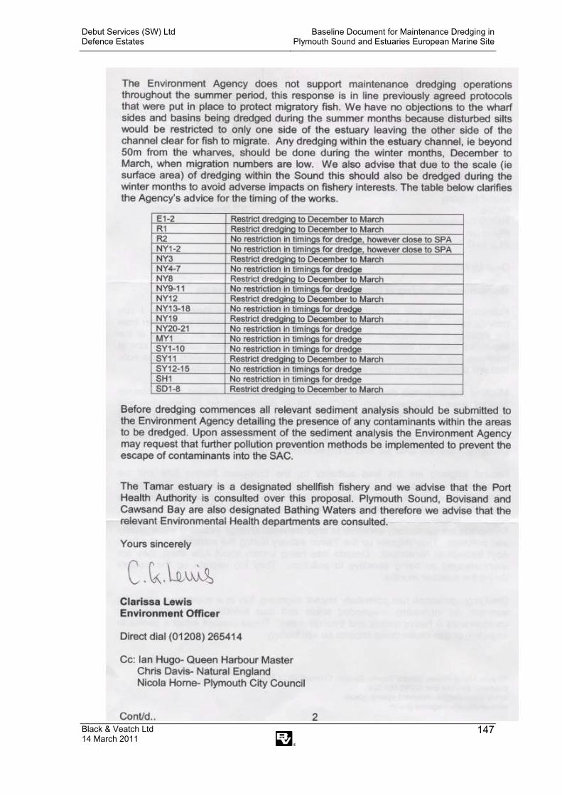
Debut Services (SW) Ltd Defence Estates
Baseline Document for Maintenance Dredging in Plymouth Sound and Estuaries European Marine Site
Black & Veatch Ltd 14 March 2011
147