Embed Size (px)
Citation preview
Basarsoft Information Technologies
COMPANY PROFILE
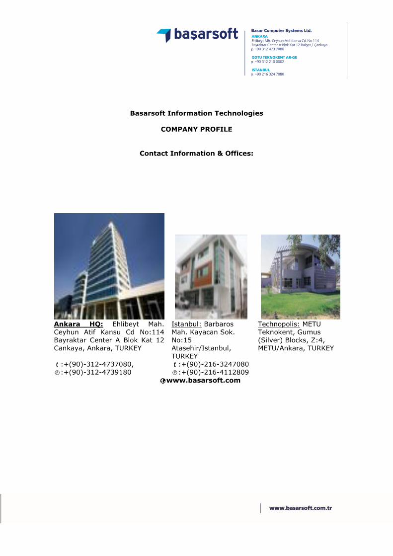
Contact Information & Offices:
Ankara HQ: Ehlibeyt Mah.
Ceyhun Atif Kansu Cd No:114
Bayraktar Center A Blok Kat 12
Cankaya, Ankara, TURKEY
Istanbul: Barbaros
Mah. Kayacan Sok.
No:15
Atasehir/Istanbul,
TURKEY
Technopolis: METU
Teknokent, Gumus
(Silver) Blocks, Z:4,
METU/Ankara, TURKEY
:+(90)-312-4737080, :+(90)-216-3247080
:+(90)-312-4739180 :+(90)-216-4112809
www.basarsoft.com
Brief Company Information:
Basarsoft’s primary working area is building Geographical Information System
(GIS) solutions, mainly with MapInfo technology, and was founded in 1997.
Basarsoft is now the MapInfo distributor in Turkey and a solution center for the middle-
east partners and has a well-established partner channel in Turkey also to deliver solutions
in MapInfo and related geographic technology.
Basarsoft delivers many industry-specific solutions to government agencies and private
companies. Basarsoft’s main activities are navigable map production, infrastructure
information systems, field data collection, turnkey customized GIS solutions, GIS Software
sales, training courses for product users, and integrated mapping applications.
Basarsoft has 3 offices: The headquarters in the capital city of Ankara, focusing mainly on
government solutions; the Istanbul branch, focusing on private sector clients; and the
Technopolis office, focusing on research and development. Basarsoft has delivered many
solutions in Turkey and the Middle East.
In 2014, Basarsoft has risen to the level of regional distributor for Pitney Bowes Business
Intelligence Software, covering the region from the Balkans and North Africa to Central
Asia and the Middle East.
Enterprise Utility Network GIS Solutions:
Basarsoft has developed nationwide projects for Telecom Wireline, Electricity, Natural Gas,
Water Distribution companies.
Custom Tailored GIS Solutions:
Basarsoft has developed the first GIS system for The Turkish Post Office, and the Ministries
of Health, Transportation, Education and Energy.
Navigation Maps & Solutions:
Basarsoft has been active in the Navigation sector since 2003. Basarsoft has continually
developed navigable maps and local navigation software for industrial use with server
connected functionality. Today, Basarsoft has the most extensive and up-to-date map
coverage for Turkey, covering whole urban, rural and centers of tourism. The local software
called Yolbil, has begun to be used by police departments in Turkey, utility and retail
companies with server side communication capabilities. Also the first fully integrated
Navigation system for Blind persons build with Yolbil SDK.

KEY STAFF:
Basarsoft has more than 350 staff. Some of the key staff members are as follows.
No Name Profession Position Since
1 Mr. Alim Kucukpehlivan BSc. Computer E.,MBA CEO 1997
2 Mr. Tuncay Kucukpehlivan MSc, BSc. Elec.Eltro. E. Vice Manager 1997
3 Mr. Ahmet Dabanli BSc. Enviro E, MSc.GIS Vice Manager 1997
4 Mr. Abdullah Efe BSc, City Planning Istanbul Project Dept 1998
5 Mr. Baris Engin BSc. Elec & Comp Eng SW Solutions Advisor 2001
6 Mr. Mehmet Ciftci BSc. Computer Eng Chief Of SW Developers 2005
7 Mr. Alper Degirmenci BSc. Computer Eng Chief Of R&D 2006
8 Mr. Yalcin Ozturk BSc. Geography Chief Of Navigation Data 2005
9 Ms. Zeynep Aci BSc. Mining Eng Chief Of Projects 2007
10 Mr. Caglayan Ozdemir BSc. Geological Eng Chief Of Field Operations 2005
11 Mr. Yalcin Ozdemir BSc. in Enviro. Eng GIS Expert 2005
12 Mr. Engin Yegnidemir BSc. Computer Eng Senior GIS Programmer 2007
13 Ms. Necla Agirman BSc. Computer Eng Telco GIS Solutions 2007
14 Mr. Gazi Kaynak BSc. Geological Eng GIS Expert in Data 2007
15 Mr. Can Yagar BSc Management 3D GIS Expert 2006
16 Mr. Emrah Yilmaz BSc. Computer Eng R&D Projects Director 2009
17 Mr. Ilker Gurcan MSc. Computer Eng Java & Android Dev. 2009
18 Ms. Derya Bozdag Surveying Tech. Utility Sector Sales 2010
19 Mr. Selim Satici BSc. & MSc. Geo. Eng Project Supervisor 2014
20 Mr. Greg Hammonds BSc. Psychology Int. Projects Supervisor 2013
21 Ms. Ayse Yazgin BSc. Mining E.MSc.GIS Int. Projects Support 2014
Awards
Basarsoft has been listed in the Deloitte FAST50 Turkey (Fastest Growing ITC
Companies, 2009 to present), Deloitte FAST500 EMEA (2012), AllWorldNetwork
FAST500 (2013), and National ITC500 (2009 to present).
Basarsoft listed in the Biggest 500 ICT Companies in Turkey from 2010 to 2014
Basarsoft has ranked #10 in size nationally among software companies since 2012
Basarsof was chosen by AllWorld Network for the Arabia Fastest 500 EMEA in 2012.

Utility Solutions & References
1. Navigation
1.1. Garmin, Turkey/Germany
Basarsoft started delivering navigable maps to the Garmin
Distributor in Turkey in January 2007. Basarsoft works with a
Garmin software called MPC to convert the raw navigable maps
into Garmin routable maps. Baytekin is selling the Basarsoft
maps under a local brand called NavCITY along with basemaps
in every handheld Garmin GPS device being sold in Turkey.
Garmin Germany has started selling NavCITY on SD cards, as an
additional option to their NUVI customers in Germany. The maps
are also offered to other European countries where Garmin has
offices and the product will soon be available in other regions
also.
1.2. NavNGo (I-GO), Hungary
Basarsoft contacted the best and most-sold mobile navigation
software company, NavNgo, for a potential map-providing
partnership contract before the CeBIT Hannover event in March
2007. After reviewing and inspecting Basarsoft’s detailed
navigable maps, NavNGo decided to change from their previous
map provider in Turkey. Basarsoft has been delivering maps to
I-GO customers since April 2007. Currently more than 600,000
Navigation licenses are sold per year in Turkey alone.
1.3. Google Maps & Earth (maps.google.com)
The leading Internet company of all time has very well known
map services called Google Earth and Google Maps. Basarsoft
has been selected as the best available data supplier for Turkey,
after thorough evaluations by Google USA. Basarsoft maps are
to be used and will be maintained by us, as long as the Google-
Basarsoft contract is valid.

1.4. Medion, Turkey/Germany
Basarsoft started delivering navigable maps for Medion devices as
Turkey Distributor in January 2008. Devices have been sold in
Germany and in Turkey, and became used by 18,000 taxi drivers in
Istanbul to serve the people living in or visiting the city.
1.5. Navitel, Turkey/ Russia
Basarsoft started delivering navigable maps to Navitel in 2010,
and the company’s navigation devices are sold and used in Turkey
and in Russia.
1.6. Blind Navigation (GörenGöz), Turkey
Basarsoft has developed Seeing Eye, a personal navigation system for people with
visual impairment. Starting from Istanbul and Ankara, the system has been distributed
nationwide in 22 cities for 10,000 people. Seeing Eye provides spoken, turn by turn
navigation and special descriptions. Features include spoken prompts for traffic lights,
the nearest bus/metro/ferry stops, wrong direction warnings, Where Am I?, battery
level, GPS and system status info, and many others specially designed for use by people
with visual impairment.
2. Telecommunication
2.1. Turkish Telecom Country wide Integrated GIS Inventory System, since
1998
Basarsoft developed and actively maintains the largest nationwide
infrastructure GIS solution for Turk Telekom. The project was designed
to centrally store, update and analyze wire line, fiber optic and DSL
infrastructure for entire cities. The network design software is used to
install and update cables, and the monitoring software is used to analyze
the system. There is a central Oracle Database to store spatial data. The
system has 800+ active users (4500+ users overall), connected via 10
application servers.
A similar system has been developed for the Vodafone Cable Company

2.2. Turksat Cable TV, since 2012
Basarsoft has developed custom applications for Turksat
Cable TV & Wireline Internet Customer Infrastructure in 22
metropolitan areas in Turkey (50% of the national
population).
3. Electricity Network Distribution Systems
3.1. KCETAS
KCTAS is the electricity distribution company for the city of
Kayseri and surrounding areas. In 1998 Basarsoft began, as a
subcontractor for KCTAS, to develop GIS software applications
for the use of maps and for the production of analyses and
reports. In 2001 KCTAS decided to try a commercially available
GIS software, but after 5 years of unsuccessful use KCTAS
decided to work again with Basarsoft. In 2007, KCTAS began
using Basarsoft’s MapInfo-based electrical utilities management
software Edabis, and became the first electricity distribution
company in Turkey to integrate its operational data in real time,
including all inventory and customer data. Using desktop and web
versions of Edabis, KCTAS is setting new trends for electricity
distribution companies nationwide, both in daily operations and
in strategic planning.
3.2. SEDAS
SEDAS is the electricity distribution company for the city of
Sakarya and the surrounding region. In 2008, a tender included
MapInfo software for managing customer address data, and as a
logical next step SEDAS decided to use Basarsoft’s MapInfo-
based electrical utilities management software, Edabis, for GIS
integration of their network. Siemens was chosen as the provider
of technology for supervisory control and data acquisition.
Basarsoft incorporated the monitoring component provided by
Siemens into an overall successful integration of the SEDAS
system. SEDAS is using Edabis desktop and web versions, and
has also recently purchased Edabis Field Force Management.

3.3. AYDEM
AYDEM distributes electricity in southwestern Turkey. In a tender
for customer address management, AYDEM successfully used
MapInfo software, and then decided to build on this by using
Basarsoft’s Edabis software throughout the organization.
Network inventory was successfully digitized, and this was
followed by integration with call center operations and field
force management. Integration of these with AYDEM’s
customer information system is now in progress. Basarsoft again
worked with Siemens, which handled the network monitoring
technology component of Basarsoft’s overall GIS integration of
AYDEM’s activities.
3.4. MEDAS
MEDAS delivers electricity in the city of Konya and other parts
of central Turkey. MEDAS has been using MapInfo software since
1998. After privatization, the new management chose to
continue working with MapInfo, and this led to their choice of
Edabis desktop and web applications, which MEDAS continues to
use actively. The adaptability of Basarsoft’s Edabis software was
shown at MEDAS by successful integration with IBM’s Maximo
software for asset management and maintenance.
3.5. AKEDAS
AKEDAS, distributor of electricity in southern Turkey, after a long
period of research and consultation, combined projects for GIS
and supervisory control and data acquisition into one tender.
Currently in this project, Basarsoft is acting as a subcontractor
for Siemens while a foundation of data is being collected.
Basarsoft’s Edabis software has been installed and is beginning
to be used. After the monitoring data are included in GIS
integration, the full capabilities of Edabis will become available,
and this will be supported by training sessions for AKEDAS staff
so they can use the software to its fullest extent.
3.6. CALIK YEDAS
YEDAS, an electricity distributor in northern Turkey, chose SAP
software for organizational use, and also wanted to integrate this
with GIS capability. Basarsoft successfully provided this
integration, with all address procedures being updated via GIS
and synchronized with SAP.

3.7. DEDAS
DEDAS, in southeastern Turkey, hired Basarsoft as a contractor
via a tender in 2014 for GIS software and field data collection.
In only two months, the new system was brought into active
use. In the following two months, integration was achieved for
analysis, automatic metering, and the farmers’ registration
system of the Ministry of Agriculture. Field data collection
continues.
3.8. ARAS EDAS
Aras, an electricity distributor in northeastern Turkey, also
through a tender in 2014 hired Basarsoft as a contractor for
GIS software and field data collection. Basarsoft established
GIS capability within the first two months of the project, and
field data collection is in progress.
3.9. GEDIZ ELEKTRIK
Gediz distributes electricity in western Turkey. Gediz decided
to use GIS software in cooperation with its sister company
Aydem, and began to use Basarsoft’s Edabis software in
September 2014.
3.10. NEDCO
In a tender made by the World Bank, Basarsoft pulled ahead of
its competitors, and with the support of a local firm, won the
contract. Training was provided for the Palestinian partners,
and Edabis desktop was brought into active use.

4. Water Sector and Distribution Network Solutions
4.1. ASKİ: Capital Ankara Water&Sewer Authorty
ASKI, the water distribution authority for the capital Ankara, had more than 4000 digital
as-is maps of the city, at 1/1000 scale in Microstation DGN format in 1996. These CAD files
were converted to MapInfo format, Basarsoft integrated them and developed client based
and web based applications for ASKI. The resulting system was able to track, via Oracle
RDBMS, all the pipes for clean water, waste-water and storm water, and all related
materials, stored at and deployed from ASKI’s central database. ASKI now also uses
MapXtreme, the intranet/internet environment of MapInfo, to open the applications to all
departments within the municipality. Also integrated into the system were ASKI’s water
flow monitoring data from their SCADA equipment and software.
Ankara, as the capital of Turkey, has a population of 4.5 million in the city center, with 1.5
million water customers. With a new tender, 50% of the customers were geocoded and
located on the map to according to their actual locations via office work alone, the
remaining customers being geolocated by a combination of office work and field surveys.
The project, Construction and maintenance departments are using the same GIS
environment integrated with other systems such as MIS, Customer Billing IS, Maintnance
Systems, Dams&Facilities Info Systems. Every single piece of pipe/fitting installations are
recorded in the systems first , before any payments done.

4.2. DİSKİ : Diyarbakır Water & Sewer Authority
DISKI, the water distribution authority for the city of Diyarbakir Metropolitan City, had CAD
based maps for the water network and there were no sewer maps. The water network
maps were converted into GIS format, enabling the inventory database to be checked for
accuracy. Sewer network data were collected from the field as textual information and
coordinates, then in the office the database was automatically converted to GIS.
Basarsoft’s work for DISKI , under another contract from kfW credited project, has also
included studies on reducing water losses. A network monitoring system for supervisory
data acquisition and control was built, and this system was integrated digitally into the GIS
environment.
Sewer pipe and manhole cleaning planning systesm created with another module, to
minimize the operational costs and not to allow cleaned pipes/manholes re-contaminated
from the dirt/sediments due to upstream cleaning.
Hyraulic model integration and calibration studies carried for the existing network system.
4.3. DESKİ: Denizli Water & Sewer Authority
DESKI, provider of water and wastewater services in Denizli
province, was managing the large local network with CAD data
and paper maps. In 2013, with Basarsoft’s water network
management software SUDABIS, all network data were
transferred into a GIS environment. Physical network and
customer address data are updated and maintained through an
SQL Server database. As the next project, GIS integration of
customer data and customer relations management are
planned.
4.4. KASKİ: Kayseri Water & Sewer Authority
KASKI, provider of water and wastewater services to the city
of Kayseri, had purchased a software system to manage their
network data in shapefile format, but were unable to use it for
web-based updates or for sufficient queries, analyses and
reports. In 2014 KASKI switched to Basarsoft’s SUDABIS for
managing their network, using both desktop and web-based
applications. In this way, KASKI successfully converted its CAD
and .shp data into a form suitable for managing network
topology, and developed a powerful, easily usable decision
support system.
5. Natural Gas Distribution GIS System
Basarsoft has worked with Siemens to deliver a complete IT solution to one of the largest
Gas companies in Turkey, Izmirgaz. Basarsoft met the company’s full range of GIS needs,
and the software solution is now being used in other cities which have recently received
licenses for natural gas distribution. Natural gas companies in Ankara, Eskisehir, Yalova,
and Izmit (Kocaeli) are some of the other customers for Basarsoft’s MapInfo based
solutions.
5.1. İzmirgaz
Izmirgaz, the natural gas distributor for the provinces of Izmir
and Tire, was formed in 2005 through a partnership of Kolin
A.Ş. and Türkerler A.Ş. Izmirgaz has the unique distinction of
being the first natural gas provider in Turkey to organize its
physical network and customer address data via GIS at the
very beginning of company operations. As a leader in
innovation, Izmirgaz uses Barasoft’s DOABIS software, which
is based on MapInfo and MapXtreme and is designed
specifically for managing natural gas networks. Address and
network data, stored in Oracle, were integrated with the
customer management system by the firm ATOS.

5.2. Eskişehirgaz
ESGAZ became the natural gas distributor for Eskisehir
province in 2004 through privatization and the firm Kolin A.Ş.
ESGAZ has been using Basarsoft’s GIS products since 2006
and, working with the firm ATOS, has successfully integrated
its customer management operations with the desktop version
of Basarsoft’s DOABIS natural gas management software.
5.3. Bursagaz
Bursagaz, natural gas provider in the Bursa region, traces its
roots back to 1989, when Botaş began investing in natural gas
infrastructure there. In 2004 these efforts passed to Çalık
Group, and in 2007 Bursagaz became the prize acquisition of
one of Europe’s infrastructure giants, EWE AG. In 2011
Bursagaz began to work with Basarsoft, and has become the
first company in its field to integrate all operations with GIS,
including customer relations management, SCADA data, field
force management and navigation, and its use of SAP software.
5.4. Kayserigaz
Kayserigaz, the sole provider of natural gas services in the
province of Kayseri since 2004, attracted the attention of EWE
AG and was acquired by that company in In 2007. In 2008
Kayserigaz began to use Basarsoft’s MapInfo-based natural gas
management software DOABIS, in desktop and web versions.
This led the way for Kayserigaz to become another of the
successful natural gas firms to integrate SAP with customer
data and GIS with customer relations management.
5.5. İzmitgaz
Izmitgaz, provider of natural gas services in the industrial
region of Izmit and Kocaeli, was founded in 2004 and joined
with GDF Suez in 2009. Since 2006 Izmitgaz has been using
GIS in its operations, and has achieved GIS integration with
customer management and asset management.

5.6. Çedaş
Cedas, founded in 2004, provides natural gas services to
approximapely 1 million customers across 5 disgtribution
regions and 9 provinces. As a leader in the field, Cedas began
working with Basarsoft in 2014, and has so far achieved GIS
integration with customer data.
6. Telco/GSM
6.1. Vodafone, Turkey
Basarsoft has delivered nationwide coverage of Turkey with
detailed maps for Vodafone’s newly established LBS platform.
Working with Vodafone IT (previously known as Oksijen),
Basarsoft also delivered the mapping engine of the LBS platform
developed by Vodafone IT. The system delivers the location of
the mobile unit and the desired point with a shortest/fastest path
and driving information with text and maps. The system was
launched in June 2007, with 18 major cities’ navigable attributes
and the remainder as a base map, covering all of Turkey.
Currently the whole range of navigation data & POI is supplied
to the Vodafone.
6.2. Turkcell, Turkcell Kıbrıs, Life Belarus Turkey
Turkcell, with more than 38 million subscribers, is the leading
GSM provider in Turkey and neighboring countries. Turkcell has
the biggest coverage in Turkey. Turkcell has been using MapInfo
solutions for years and also has bought street data from
Basarsoft.
6.3. Avea, Turkey
Avea, GSM operator in Turkey, has the most subscribers in civil
service. Avea uses MapInfo technologies.

7. Government
7.1. General Directorate Of National Property
In line with its vision, the main function of the General Directorate of National Property is
to efficiently manage over one-fourth of the total land area in Turkey, allocating national
parcels for public services, and selling or renting some parcels to get revenue.
Başarsoft’s specially designed National Property GIS System (MEOP GIS) enables the
Directorate to manage and monitor each and every parcel in every region of the country
in a seamless database; to compare the unit prices of neighboring parcels; to evaluate the
status of immovable assets; and to create value in the country’s economy.
7.2. Ministry of Forestry and Water Affairs
Basarsoft has developed a Map Based Analysis Software for Flooding & Erosion Control
- Several processes are carried out such as data crafting and data transformation.
After that, on the field, data accuracy is checked and input of software structure is
checked.
- With the using of data set which is produced by Ministry ; 30m x 30m grids were
created on the application and water resources and their flow direction were entered
to the system. Additionally, in case of the possible precipitation, region of potential
flood were calculated and presented with the help of software
- The following layers were used for the application;
Digital Elevation Model, Topographic Slope, Slope Orientation, Drainage - Drainage
Density - Drainage Frequency, Coefficient of Surface Flow, Land Use Status (Remote
Sensing, Stand, Corina), Hydraulic soil properties (structure, depth, permeability, etc.),
Topographic Humidity Index, Rivers Erosion Strength Index, Sediment Transport
Capacity Index, Geological structure, Erosion status, Meteorological data (rainfall,
Radar, evaporation, temperature, snow, etc.).

7.3. Ministry of Forestry and Agriculture
Basarsoft has developed a Map Based Monitoring and Reporting System for the former
Ministry of Forestry and Agriculture in 2004. This system handles yearly statistics on
production of agricultural goods and surface areas of farmlands and forests. Also the
system is used to track the yearly additions of new forest areas and changed areas. Forest
types and densities can also be entered or analyzed via the system.
7.4. Ministry of National Education, Turkey
A Microsoft-financed project has started at the beginning of 2004 and finished at the end
of 2006. Basarsoft developed a Map Based Decision Support System by using .NET
technology, on web and desktop platforms. Basarsoft also delivered city level data on street
networks and schools in detail for all of the provincial centers in Turkey (81 provinces).
The system is designed to work with Microsoft OLAP cubes on MS SQL Server databases
that represent 40,000 schools, 400,000 teachers and 10 million+ students. The system
tracks existing and past education infrastructure and enables accurate projections of the
future, so that appropriate investments can be made in personnel and facilities. The entire
system is working on a pure .NET platform. SENTIM, a major integrator, is developing the
web portals for the systems. A similar system was developed for the Ministry of Health in
2007 as an information portal for General Practitioner physicians.
7.5. Ministry of Health, Turkey
Basarsoft has developed a Map Based Decision Support System for desktop and web
platforms. Basarsoft also digitized and/or geocoded all hospitals and local health units, and
integrated these with personnel and inventory databases to report statistics at the province
and city level.
This system is integrated with the Oracle BI reporting system, to map-enable all reports
built in Oracle Business Intelligence. Example procedures include averages and top 10
analyses, and these can be projected on the map to reveal geographic patterns in water
quality, infections, birth and mortality rates, etc.
Water quality in water distribution systems, at swimming areas and at water bottling
facilities is also monitored by GPS-enabled measurements.

7.6. Turkish Post Office (PTT)
PTT has opened a tender for managing postal delivery via handheld GPS-enabled terminals.
This requires the creation of a basemap for postal delivery routes including the building
numbers on the streetmaps. Sentim, one of the largest system integrators, has been
awarded this project and Basarsoft, being a subcontractor for them, collected and
integrated all the door numbers for 81 provincial centers up to June 2008. This
level of data will be available only to Basarsoft’s customers.
8. Security
8.1. Traffic Information System, TURKEY
The Turkish Police Organization awarded an 8 Million USD contract to Siemens Business
Services (SBS) to redevelop the IT structure of the Traffic Center. Başarsoft delivered the
GIS infrastructure, maps, software and development to SBS in this project. 230 police units
on all major national roads connected with GPRS infrastructure to the Center, tracked and
managed in GIS. Statistical reports on traffic accidents, roadway blind spots, and many
other parameters were delivered to managers and public users for different purposes via
MapInfo tools. The project’s second phase was completed in 2007 with an addition of 1200
more tablet PCs in the field and updating of the system.
9. Completed International Projects
9.1. Al-Madinah Municipality GIS Project, Saudi Arabia
The Municipality of Al-Madinah awarded a contract to re-
engineer all of their text-based applications and move them
into a GIS based operational and management system.
Ageotech sub-contracted this work to Basarsoft. The series of
contracts started in January 2001 and the final one was fulfilled
in April 2006. The system is up and running currently. More
than 40 applications are running in the system, ranging from
data collection to residency permits.
9.2. Al-Madinah Water Department GIS Project, Saudi Arabia
While successfully managing the Al-Madinah Municipality
project, Basarsoft was awarded continuing support and
enhancement projects for the Al-Madinah Water Department
during the same period (2001-2006). Water and wastewater
networks were digitized in a GIS Environment and several
integrations were made with the customer service, project
development and maintenance departments.
Applications developed for automated Benchmarking reports
based on United Nations criteiras, such as serviceable area
percentage, failure in network percentage, etc.
Water & Wastewater Hydrulic integrations with GIS were
established.
MIS applications are map-enabled with integrating GIS
system to MIS.
9.3. Albania Telecom GIS Project, Albania
Basarsoft in 2013 developed and continues to maintain GIS-
based infrastructure solutions for AlbTelecom, the main
provider of telephone and internet services in Albania. The
project was designed to centrally store, update and analyze
wire line, fiber optic and DSL infrastructure for entire cities. The
network design program is used to create and update cables,
and the Monitoring program is used to analyze system
operations. Spatial data are stored in a central Oracle Database
and 20+ clients are connected to a central application server.
9.4. Ramallah Electricity Project, Palestine
Basarsoft in 2013 developed GIS-based infrastructure solutions
for the Palestine Electricity Inventory project. The project was
designed to register all inventory in the field with GPS, along
with customer data including postal addresses and electricity
connections from transformers to residences.