Embed Size (px)
Citation preview

JRPP (Northern Region) Business Paper – 9 December 2009 – Item No. 1 Page 1
JRPP No: Item 1 (2009NTH003)
DA No: DA 2009/0263
PROPOSED DEVELOPMENT
STAGED CONSTRUCTION OF RETAIL COMPLEX COMPRISING SUPERMARKET, SHOPS & PUBLIC CARPARKING, REPLACEMENT BUS TERMINAL AND 1 INTO 2 TORRENS LOT COMMERCIAL SUBDIVISION - LOT 2 DP 850217, 28 HAYWARD STREET, PORT MACQUARIE
APPLICANT: KING & CAMPBELL PTY LTD
REPORT BY: PORT MACQUARIE-HASTINGS COUNCIL
Assessment Report and Recommendation ________________________________________________________________PRECIS This report considers a Development Application for the above proposed development. The matter is being reported to the Joint Regional Planning Panel as the proposal is a ‘regional development’ in accordance with the State Environmental Planning Policy (Major Development) 2005. The proposal is also an ‘integrated development’ for the purposes of the Water Management Act 2000. 6 submissions have been received following the public exhibition of the proposal. The proposal has been amended during the assessment of the application. RECOMMENDATION That DA 2009/0263 for a staged construction of: - A retail complex comprising supermarket, shops, and replacement public carparking; - Replacement bus terminal; and - a 1 into 2 torrens lot commercial subdivision at Lot 2, DP 850217, No. 28 Hayward Street, Port Macquarie, be determined by granting consent, subject to the recommended conditions.

JRPP (Northern Region) Business Paper – 9 December 2009 – Item No. 1 Page 2
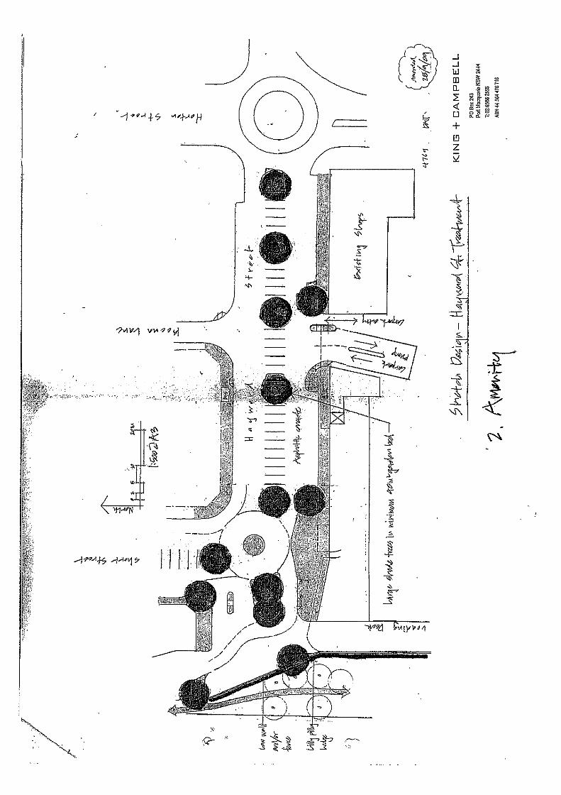
1. BACKGROUND Existing sites features and Surrounding development The site has an area 6413 m2 and is irregular in shape. The site has frontages of 41.535m to Gordon Street and 96.115m to Hayward Street. The site is currently occupied by an existing bus terminal interchange which has frontage to Hayward Street, an existing public carpark with 154 carparking spaces accessed from a roundabout in Hayward Street and an area of open space. The site was reclaimed from part of Kooloonbung Creek in the 1960s/1970s. The site is zoned 3(a) General Business pursuant to the Hastings Local Environmental Plan 2001, as shown in the following zoning plan overlay:
The existing subdivision pattern and location of existing development within the immediate locality is shown in the following aerial photo:

JRPP (Northern Region) Business Paper – 9 December 2009 – Item No. 1 Page 3
Previous applications on the site
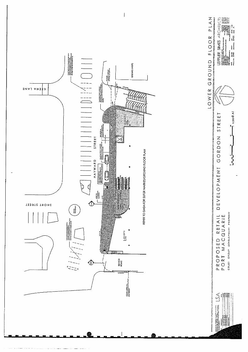
A previous DA 2008/224 for a retail complex was approved by Council on 17 December 2008 on the site together with Lots 2,3 and B shown in the above image (lots fronting Horton Street). 2. DESCRIPTION OF DEVELOPMENT In summary, the application proposes the following: • Demolition of the existing bus interchange • Demolition of the existing public carpark • The construction of a new replacement bus interchange with frontage to Gordon
Street and Kooloonbung Creek reserve • 1 into 2 lot torrens title commercial subdivision • The construction of a building comprising basement car parking, a retail level which
includes a supermarket (Coles), 2 shops and a level of carparking on the roof of the building (154 of 163 of these parking spaces will be public parking spaces which are proposed to be administered and managed by Council by way of a deed of agreement) which is accessed on the roof of the building
JRPP (Northern Region) Business Paper – 9 December 2009 – Item No. 1 Page 4
• A lift and travelators within an proposed enclosed lobby on the Hayward Street frontage will connect the 3 levels of the building
• External advertising signage • A loading dock and back of house facilities (office and storage areas) servicing the
supermarket will be provided within the building accessed off Hayward Street • Proposed trading hours for the supermarket of 6.00am to 12.00 midnight, 7 days per
week • Proposed delivery and waste collection hours for the supermarket of 6.00am to
10.00pm, 7 days a week The development is proposed to be carried out in stages as follows: 1. Construction of the proposed bus terminal 2. Completion of the subdivision to create a separate parcel to contain the bus terminal 3. Demolition of the existing bus terminal and public carpark 4. Construction of the building containing the supermarket, shops and carparking. Attachments - site plans and elevations Refer to attachments at the end of this report. 3. APPLICATION CHRONOLOGY 24 July 2009 - DA lodged with Council. 31 July 2009 - Brief on DA provided to Council Executive Management to determine whether internal staff resources be used to assess DA 11 August 2009 - Referral sent to Department of Water and Energy to seek integrated concurrence under Water Management Act 2000 11 August 2009 - Referral sent to the New South Wales Roads and Traffic Authority (NSW RTA) to seek comments pursuant to State Environmental Planning Policy (Infrastructure) 2007 11 August 2009 - Copies of DA documentation sent to Joint Regional Planning Panel secretariat 13 August 2009 - Assessment officer advised that Council Executive Management resolved that DA be assessed using internal staff resources at meeting on 4 August 2009. 13 August 2009 - Additional copies of DA documentation received from applicant 21 August to 21 September 2009 - Public exhibition of proposal via neighbour notification and advertisement in local newspaper in accordance with Council's DCP 2006 and Environmental Planning and Assessment Regulation 2000 24 August 2009 - Additional information requested from applicant. 28 August 2009 - Additional information received from applicant. 7 September 2009 - Written advice received from NSW RTA 18 September 2009 - Copy of NSW RTA advice forwarded to applicant 19 September 2009 - Applicant provided with copy of written advice provided from NSW RTA on previous DA 2008/0224 as requested 4 September 2009 - Additional information received from applicant 11 September 2009 - Additional information received from applicant 7 October 2009 - Additional information requested from applicant 4 November 2009 - Additional information requested from applicant 4 November 2009 - Additional information received from applicant

JRPP (Northern Region) Business Paper – 9 December 2009 – Item No. 1 Page 5
11 November 2009 - Additional information received from applicant 12 November 2009 - Additional information received from applicant 18 November 2009 - Advice received from Department of Water and Energy in relation to Integrated concurrence under Water Management Act 2000 20 November 2009 - Additional information received from applicant 4. STATUTORY ASSESSMENT Section 79C Matters for Consideration In determining the application, Council is required to take into consideration the following matters as are relevant to the development that apply to the land to which the development application relates: (a) The provisions (where applicable) of: (i) any Environmental Planning Instrument: State Environmental Planning Policy No.55 – Remediation of Land
In accordance with clause 7, the applicant has submitted details in a report prepared by Cavvanba Consulting that the site has been subject to preliminary testing in order to ascertain the presence of substances or other elements requiring remediation. In summary, the Cavvanba report details the following: • The site was reclaimed from being part of Kooloonbung Creek in the 1960s/1970s. • The activities on the site conducted appear to have been limited to filling and
subsequent carparking and landscaping. There is potential for the fill material to include demolition waste, drums etc and minor spills of oil or fuels to have occurred during it use as a carpark. It is possible that fill from sources other than sand dredging have been placed on the site.
• The bus terminal does not include any refuelling facilities and is merely a pickup point for passengers including some amenities.
• It is evident that a stabilising aggregate eg. roadbase has been placed on the surface to facilitate the asphalt surface and carparking.
• Groundwater was observed to be at approximately 2.0m depth. • Apart from the fill on the site no on-site sources of contamination were visible. • Off-site sources of potential contamination include the former service station and the
dry cleaners, both of which are located up-topographic gradient of the site. • Based upon the scope of work undertaken, the site is likely to be suitable for the
proposed commercial landuse, with appropriate management of any potential the groundwater contamination.
• Development of a suitable management approach will require additional data input obtained through more intrusive, focused investigation of the potential contaminants migrating onto the site from adjacent properties.
• Additional investigations should include the installation of additional monitoring wells, replacement of the monitoring wells installed as part of this investigation, and investigation of details of the existing monitoring well.
JRPP (Northern Region) Business Paper – 9 December 2009 – Item No. 1 Page 6
It is recommended that compliance with the Cavvanba report be conditioned to be required to be complied with prior to and during construction of the development be a condition of consent. The requirements of this SEPP are therefore satisfied. State Environmental Planning Policy No.64 - Advertising and Signage
The proposed development includes proposed advertising signage as depicted in the submitted elevation plans.
In accordance with clause 7, this SEPP prevails over the Hastings LEP 2001 in the event of any inconsistency. Refer to the assessment table following this table for compliance with specific requirements of this SEPP. The proposed signage satisfies all listed requirements. The requirements of this SEPP are therefore satisfied. State Environmental Planning Policy No.71 – Coastal Protection
The site is located within a coastal zone as defined in accordance with clause 4. The site is further identified as a sensitive coastal location. In accordance with clause 7, this SEPP prevails over the Hastings LEP 2001 in the event of any inconsistency. Refer to the assessment table following this table for compliance with specific requirements of this SEPP. The requirements of this SEPP are therefore satisfied. State Environmental Planning Policy (Infrastructure) 2007
In accordance with clause 104 and Schedule 3, the proposed development is a 'traffic generating development' for the purposes of this SEPP. The proposal includes provision of a new vehicular access off Gordon Street, which is a classified road. In accordance with clause 104 the following requirements apply: (3) Before determining a development application for development to which this clause applies, the consent authority must:
(a) give written notice of the application to the RTA within 7 days after the application is made, and (b) take into consideration:
(i) any submission that the RTA provides in response to that notice within 21 days after the notice was given (unless, before the 21 days have passed, the RTA advises that it will not be making a submission), and (ii) the accessibility of the site concerned, including: (A) the efficiency of movement of people and freight to and from the site and the extent of multi-purpose trips, and (B) the potential to minimise the need for travel by car and to maximise movement of freight in containers or bulk freight by rail, and

JRPP (Northern Region) Business Paper – 9 December 2009 – Item No. 1 Page 7
(iii) any potential traffic safety, road congestion or parking implications of the development.
(4) The consent authority must give the RTA a copy of the determination of the application within 7 days after the determination is made. In this regard, the application has been referred to the NSW RTA. A copy of the advice provided from the RTA is provided in the attachments section of this report. Initial issues raised by the RTA have been forwarded to the applicant to provide the opportunity to respond to together with Council initial assessment concerns. Refer to assessment details later in this report which under heading 'access, transport and traffic' for consideration of the proposal in accordance with this SEPP and details in response to the RTA's concerns. A copy of the determination of the DA will be forwarded to the RTA following issue of the notice of determination to the applicant. The requirements of this SEPP are therefore satisfied. State Environmental Planning Policy (Major Development) 2005
In accordance with clause 13B, the proposed development is a 'regional development' due to: • The estimated capital investment value being greater than the $10 million (being
$18.05 million) • The proposal being on Council owned land and valued over $5 million. In accordance with clause 13F, Council is the consent authority for the proposed development, however the determination of the DA is required to be made by a Joint Regional Planning Panel. The DA is therefore reported to the JRPP for determination. Following a determination being made by the JRPP, Council will be required issue the determination notice in accordance with this clause. The requirements of this SEPP are therefore satisfied subject the JRPP making determination of the DA. North Coast Regional Environmental Plan
In accordance with clause 2 and 2B, the proposal will not contravene any of the aims of this REP.
In accordance with clause 32B(2) the following guidelines are be taken into consideration:
(a) the NSW Coastal Policy 1997, (b) the Coastline Management Manual, and (c) the North Coast: Design Guidelines.
The applicant has submitted details that the preparation of the proposal has taken into consideration of these guidelines and policy documents. The development site is also not directly adjoining any defined 'waterfront' open space area.
In accordance with clause 32B(3), consent must not be granted to the carrying out of development which would impede public access to a foreshore. In this regard, the

JRPP (Northern Region) Business Paper – 9 December 2009 – Item No. 1 Page 8
proposal will not adversely affect existing public access points to the adjoining Kooloonbung Creek foreshore. Additional embellishment of this Crown reserve is proposed to be undertaken as part of the development which will include improved accessible access from Gordon Street.
In accordance with clause 36F, consent must not be granted to the carrying out of development on land in the vicinity of a heritage item unless it has made an assessment of the effect the carrying out of that development will have on the heritage significance of the item and its setting. In this regard, the proposal will not have any identifiable adverse impacts to any heritage listed items within proximity to the site. Additional details are provided later in this report under Hastings LEP 2001. As part of the assessment of the previous DA 2008/224 on the site, Council’s nominated heritage advisor (at the time) provided comments that no concerns were raised with any potential impacts on the settings of these items for that commercial proposal.
In accordance with clause 81, consent must not be granted for development on land within 100 metres of the ocean or any substantial waterway unless it is satisfied that:
(a) there is a sufficient foreshore open space which is accessible and open to the public within the vicinity of the proposed development, (b) buildings to be erected as part of the development will not detract from the amenity of the waterway, and (c) the development is consistent with the principles of any foreshore management plan applying to the area.
The applicant has submitted the following details, adequately addressing the REP:
• There is sufficient foreshore open space which is accessible and open to the public within the vicinity of the proposed development.
• Buildings to be erected as part of development will not detract from the amenity of the waterway; and
• The development is consistent with the principles of the foreshore management plan which applies to the area.
The requirements of this REP are therefore satisfied. Hastings Local Environmental Plan 2001
In accordance with clause 9, the subject site is zoned 3(a) General Business. The adjoining Crown reserve, as part of Kooloonbung Creek, is zoned 6(a) Open Space.
The proposed development includes landuses which can be best as 'general store', 'shop', 'car park' and 'bus station' for the purposes of the LEP, which are permissible landuses with consent within the 3(a) zone.
In accordance with clause 9(2), the objectives of the 3(a) zone require consideration as follows:
(a) To allow a range of retail, office and commercial development appropriate to the status and function of the particular retail centre within the zone. (b) To allow a wide range of uses which may be ancillary to, supportive of, or
appropriately located near, or within, retail and commercial facilities. (c) To facilitate strong, multi-functional town centres. (d) To enable appropriate development where allowed with consent.
The proposal satisfies the objectives of this zone for the following reasons:

JRPP (Northern Region) Business Paper – 9 December 2009 – Item No. 1 Page 9
• All landuses are permissible within the 3(a) zone with consent; • The applicant has submitted details that the proposed supermarket will replace an
existing supermarket and will be supported by 2 proposed shops. The shops will assist with the activation of the adjacent section of Hayward Street and in turn assist with the strengthening of this part of the town centre.
• The applicant has submitted details that the proposed retention of the public carpark and bus terminal will also be supportive of the multi-functional nature of the town centre.
In accordance with clause 13, satisfactory arrangements are available for water supply and facilities for removal/disposal of sewage and drainage to the proposal.
In accordance with clause 25, in the case of flood liable land the following shall be taken into consideration:
(3).... consent shall not be granted to development of the land unless a survey identifying the level of the land relative to the 1 in 100 year flood level has been completed.
A site survey of the land identifying existing levels has been submitted with the DA. The likely 1:100 year flood level expected to affect the site is to RL 2.55 AHD (without consideration for any potential climate change impacts).
(4) Consent shall not be granted to development of any flood liable land unless the consent authority has considered:
(a) the likelihood of loss of life or property from flooding, and
(b) the likelihood of increased demand for flood mitigation measures and emergency services, and
(c) any impediments to the operation of floodway systems in times of flood, and
(d) the effect of proposed development on adjoining land in times of flood, and
(e) limits on the intensity of development of urban flood liable land, and
(f) the provision of services and facilities appropriate to the flood liability of the land.
In this regard, the applicant has provided the following details:
• The basement car park will be below the 1:100 year flood level. • Access to the carpark will be from Hayward Street and will be via a ramp which will
be graded in such a way that it goes above the 1 in 100 year flood level, before going down to the basement, thereby flood proofing it.
• The entry to the loading dock is proposed to be below the 1 in 100 year flood level. This area will be sealed to prevent water entering the building.
• The bus terminal will be above the 1 in 100 year flood level. • The adjacent streets are generally above the 1 in 100 year flood level, although a
section of Hayward Street west of Keena lane, grades down to levels below the 1 in 100 year flood level. This, however, is not considered to represent a major safety issue.
Comments with regard to flooding are as follows:
• The site is flood affected, including the full frontage to Hayward Street. The vehicular access to the basement carpark is within this location, as well as the truck loading ramps. It is proposed to protect the basement carpark from flooding by grading the

JRPP (Northern Region) Business Paper – 9 December 2009 – Item No. 1 Page 10
entrance ramp above the 1:100 ARI event. In addition, it is proposed to seal the truck loading bays so that water does not enter the loading bay area. A flood management plan shall be submitted and approved by Council before a Certificate of Occupancy is issued.
• The current 1:100 year flood level is 2.55m AHD. The 1:20 year level is 2.30m AHD. • Council's flood policy requires commercial development to be at the 1:100 level and
all basement carparks to be protected from the 1:100 year event. Note: The above levels do not include Climate Change (sea level rise) and as such the development should allow for an adoptable approach and provide for a 400mm increase in flood levels due to sea level rise over the next 50 years.
In accordance with clause 26, the site has class 3 potential acid sulfate soils (ASS) across the majority of the site. This clause requires (with potential class 3 ASS) that where proposed works are proposed beyond 1 metre below the natural surface, consent must not be granted unless Council has considered a preliminary soil assessment determining the presence or absence of potential or actual acid sulfate soils within the area of the landform alteration. In this regard, construction of the proposed development will likely require excavation greater than 1m below the existing ground surface. The applicant has provided details that this matter could be appropriately addressed via a condition of consent. It is recommended that whilst limited details are available, this approach will be appropriate via inclusion of a condition to require that an acid sulfate soils management plan be prepared in accordance with the Acid Sulfate Soils Manual, published by the Acid Sulfate Soils Management Advisory Committee prior to issue of a construction certificate.
In accordance with clause 34, consent must not be granted to development on land in the vicinity of a heritage item unless an assessment of the effect the carrying out of that development will have on the heritage significance of the item and its setting. In this regard, there are 2 heritage items in the vicinity of the site, 1 being a convict well at 158 Horton Street and the other Historic Cemetery on the southern side of Gordon Street. The applicant submits that the proposed development will not adversely impact on the heritage significance of the existing nearby convict well primarily as the proposal is located on an allotment of land on the opposite side of Gordon Street. It is agreed that adequate separation/curtilage is afforded to the heritage items and their integrity will remain in tact. No significant adverse impacts can be identified.
In accordance with clause 37, where the consent authority receives an application for consent to carry out development involving the excavation or filling of land, or the erection or Error! Hyperlink reference not valid. of buildings on land identified on the zoning map as a potential archaeological site, it must not grant consent unless it has considered a report which includes an assessment of how the proposed development would affect the archaeological significance of the site. In this regard, the applicant has submitted satisfactory details that in 1958 the subject land formed part of the Kooloonbung estuary. The land was reclaimed in the mid to late 1960s and the applicant has stated that it is unlikely that the land will contain any items of archaeological significance. Additionally it is noted that as part of assessment report for DA 2008/224 the following comments were made: A historical and archaeological assessment prepared by Edward Higginbotham & Associates Pty Ltd has been submitted which relates to Lot B DP: 212735, 165 Horton Street, Lots 2 and 3 Section 10A DP 758852, 159 Horton Street. A copy of advice from the NSW Heritage Office providing an excavation exception under section 140 of the

JRPP (Northern Region) Business Paper – 9 December 2009 – Item No. 1 Page 11
Heritage Act 1977 has been provided which relates to Lot B DP: 212735, 165 Horton Street, Lots 2 and 3 Section 10A DP 758852, 159 Horton Street. Details have been provided that the remainder of the site Lot 2 DP: 850217, 28 Hayward Street, is reclaimed land and considered to not bear considerable archaeological significance. Figure 2.13 and 2.14 of the Edward Higginbotham & Associates report shows a survey completed on 9 September 1960 for the Kooloonbung Creek reclamation and aerial photo taken in 1960 showing no existing buildings on the now Lot 2 DP: 850217. In the 1960’s land was reclaimed with a large part of the Kooloonbung watercourse and the canalisation of the creek at the western edge of its original course.
In accordance with clause 40, Consent must not be granted to the display of an advertisement unless:
(a) the advertisement relates to the use of the land on which it is to be displayed, or ... (c) the sign complies with the provisions of Development Control Plan No 7—Policy on Advertisements.
In this regard, the proposal includes proposed advertising signage. The proposed signage relates to the proposed uses of the site and complies with the requirements of DCP 7. The requirements of this LEP are therefore satisfied. Any draft instruments on applies or on exhibition pursuant to Section 47(b) or 66(1)(b): No draft EPIs applicable (iii) any Development Control Plan in force under Section 72: Port Macquarie Hastings Development Control Plan 2006: DCP 7 – Policy on Advertisements
The proposal includes proposed advertising signage which complies with the applicable provisions of this DCP. Relevant factors for consideration are included in SEPP 64 assessment in the attachments to this report.
DCP 17 – Subdivision Code
The proposal includes a proposed 1 into 2 lot torrens title subdivision which complies with the applicable provisions of this DCP.
DCP 18 – Off-street Parking Code
The proposal includes provision of off-street carparking which complies with the provisions of this DCP. Refer to the attached tabled assessment of the proposal in accordance with applicable requirements of this DCP.
JRPP (Northern Region) Business Paper – 9 December 2009 – Item No. 1 Page 12
DCP 20 – Port Macquarie Town Centre
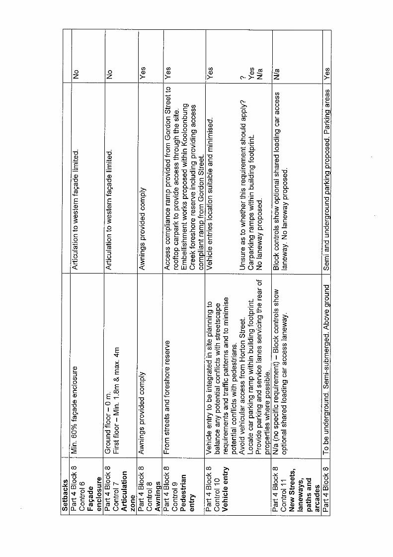
The attached tabled assessment provides an assessment check of the proposal in accordance with applicable requirements of this DCP. The assessment reveals a number of matters of non-compliance. The following comments are provided with regard to a merit assessment of the most significant matters:
Provision not being made for a new laneway providing a mid block connection
Principle 8 of the section in Part 2 headed 'Street Hierarchy' states that 'where possible, access to parking and service areas should be via a lane accessing the rear of properties'.
The subject property has two street frontages and accordingly does not have a rear lane (in the sense) contemplated by DCP 20.
These frontages have been able to be utilised to provide direct access to the proposed parking areas as well as the proposed loading dock.
Lack of activation of Kooloonbung Creek, location of loading dock and amalgamation of lots within urban block not possible
The DCP identifies the site as being substantially intended to be utilised for large floor plate retailing. The DCP suggests that properties be amalgamated for this purpose. The applicant has advised that whilst this might be theoretically possible, the form of the property ownership within the block makes this very difficult to achieve in practice. The applicant contends that it is not possible in the subject case.
As conditions of sale of the land that the existing 154 parking spaces are required to be retained in any development of the land and that the bus terminal must also be retained on the land.
In order to provide parking on a single level, a large part of the land area needs to be utilised. To spread the parking over two levels would add significantly to the cost of the development as well as increase its height.
Both the required public parking spaces and bus terminal are critical elements of public infrastructure serving the needs of the broader community. The proposed supermarket requires a footprint which covers a substantial percentage of the land and be on a single level. To create an alternate parcel of sufficient size to accommodate the supermarket, by amalgamations, would be difficult to achieve in a practical sense.
The proposed embellishments including lighting and landscaping of the adjoining Kooloonbung Creek reserve adjoining the western frontage will improve the amenity of this area significantly.
If the loading dock was required to be relocated to the Gordon Street frontage, this frontage would lack amenity and not be adequately activated. The applicant submits that the access to the loading dock off the western section of Hayward Street is where there is likely to limited traffic.
The applicant contends that the proposed architectural treatment of the western elevation is clean and simple and will accentuate the horizontal perception of the elevation which will have the effect of minimising the perception of height of the wall when viewing this elevation.

JRPP (Northern Region) Business Paper – 9 December 2009 – Item No. 1 Page 13
It is agreed with the applicant's contentions that taking into consideration of the above factors it would not be practical to develop the land to its desired use and at the same time activate the frontage to Kooloonbung Creek. An appropriate balance is considered to have been achieved.
Appropriateness of location of relocated replacement bus terminal to Gordon Street
On page 36 of DCP 20 an alternate bus interchange location is identified to be possible along the frontage to Gordon Street to which appears to be sited where the Finnians Tavern is. The applicant contends that the location of the bus terminal on Gordon Street as being generally consistent with the provisions of DCP 20. The applicant has also advised that the potential location of the terminal in Gordon Street was partly based on the consideration that this location had advantages in terms of ease of access by bus operators.
The proposal has been amended during the assessment of the application to provide for a layby for buses which are likely to be pulling up in front of the terminal. This will increase the visibility for vehicles exiting the upper level carpark to Gordon Street.
The terminal will address Gordon Street thereby contributing to the activation of the street. This in turn will facilitate better integration of the supermarket with the remainder of the town centre, particularly other shopping outlets in Short Street.
Significantly improved lighting together with comprehensive live monitored CCTV cameras providing surveillance of all faces of the building will improve the safety of the area generally. Bus access to a terminal in Gordon Street will be easier for buses which will not need to enter the town centre fully assisting the management of the traffic in the town centre.
The applicant has provided the following details, as summarised, in response to the CPTED assessment that has been carried out by the NSW Police Service:
• It is not correct that the report states that the only way patrons of the bus terminal can access the rest of the CBD is via the reserve along the Kooloonbung Creek reserve. Patrons could just as easily access the town centre via Gordon Street and Horton Street or via the pedestrian pathway through the rooftop carpark to Hayward Street, which will be well lit and subject to CCTV camera surveillance.
• An inspection of the business premises in Short Street would suggest that there would be little point in going there after normal business hours as the vast majority of businesses in this location would not be of interest to patrons of the bus terminal and would close at the cessation of the normal business hours. The Coles supermarket is currently located in Short Street but is to be relocated as part of the proposed development.
• Finnians Tavern is likely to meet some of the needs of people using the bus terminal.
• Other potential food outlets are Kentucky Fried Chicken which is located in Horton Street which closes at 10pm each night.
• The nearest takeaway food shop in the CBD is located at the corner of Horton and William Streets. There is also a bakery located in Horton Street and newsagent on the corner of Horton and Hayward Streets and these facilities are not likely to be open late at night.

JRPP (Northern Region) Business Paper – 9 December 2009 – Item No. 1 Page 14
• Access to the proposed supermarket will be via 3 routes. The most direct will be via utilising the pedestrian link through the rooftop carpark. This route will be well lit and subject to CCTV camera surveillance. It will also be possible to access the supermarket via the Kooloonbung reserve and via Gordon, Horton and Hayward Streets.
• It would seem that the primary time period of concern from a safety perspective will be late at night. To the applicant's knowledge, nothing in the vicinity of the terminal is open after 10 pm other than the Finnians Tavern. Accordingly, it is unlikely that people using the bus terminal late at night will use the reserve along Kooloonbung Creek to access the remainder of the town centre at this time.
• Plans have been submitted which indicate that the Kooloonbung Creek reserve will be subject to embellishment improvements including lighting. Additionally, CCTV cameras which will subject to live monitoring will provide surveillance of all aspects of the proposed building.
• The bus terminal and its surrounds will also be well lit. All of these elements will significantly improve the safety of the area generally, including the area proposed to the occupied by the bus terminal.
• The Gordon Street location of the bus terminal will see significantly more passing traffic with the surveillance that comes from that, than the existing or proposed site in Hayward Street. To suggest that the proposed terminal will only be subject to reduced levels of police surveillance because they focus on identified hotspots also seems contradictory to the view that it will be a vulnerable location.
DCP 34 – Acid Sulphate Soils
Refer to comments provided earlier in this report under clause 37 of Hastings LEP 2001. The proposal is capable of compliance with the requirements of this DCP. DCP 40 - Advertising of Development
The proposed development has been publicly exhibited via neighbour notification letters and an advertisement in the local newspaper for a period in accordance with Environmental Planning and Assessment Regulation 2000 requirements for nominated integrated development and this DCP.
DCP 41 – Building Construction & Site Management
The proposal is capable of compliance with the building construction and site management requirements of this DCP subject to the recommended conditions. (iiia) any planning agreement that has been entered into under Section 93f or any draft planning agreement that a developer has offered to enter into under Section 93f: No planning agreement has been offered or entered into relating to the site. iv) any matters prescribed by the Regulations:

JRPP (Northern Region) Business Paper – 9 December 2009 – Item No. 1 Page 15
NSW Coastal Policy 1997
The proposed development is consistent with the objectives and strategic actions of this policy. Relevant matters for consideration are contained in SEPP 71 assessment.
Demolition of buildings AS 2601 - Cl 66 (b)
Demolition of the existing building on the site is capable of compliance with this Australian Standard and is recommended to be conditioned. (b) The likely impacts of that development, including environmental impacts on both the natural and built environments and the social and economic impacts in the locality: Context & Setting
The site is currently occupied by an existing bus terminal interchange which has frontage to Hayward Street, an existing public carpark with 154 carparking spaces accessed from a roundabout in Hayward Street and an area of open space. The site is affected by an easement for batter (supporting Gordon Street). The Lot is bounded by Kooloonbung Creek reserve (west), Hayward Street (north), existing commercial properties (east), and Gordon Street and a commercial property (south). Access, Transport & Traffic Roads
Hayward Street and Horton Street are public roads under the care and control of Council. Gordon Street is a classified road (Main Road) and although Council is the road authority, RTA concurrence is required for any proposed works. Traffic
There has been much discussion on the application between the applicant, Council and the RTA. RTA comments relating to the impacts of road safety, efficiency and traffic management were detailed in a letter from RTA dated 4 September 2009 and are as follows: (Development Engineer response in brackets) – 1. The proposed access to Gordon Street will require approval and concurrence in
accordance with Section 138 of the Roads Act.
(Agreed) 2. It has been demonstrated that the proposed development will have a cumulative impact on the existing road infrastructure such as the three existing roundabouts at Hayward/Short Street, Hayward/Horton Street and Horton/Gordon Street. An equitable contribution should be made toward the upgrade of these facilities in the future do to the impact on their efficiency.

JRPP (Northern Region) Business Paper – 9 December 2009 – Item No. 1 Page 16
(Agreed. Improvements will be required as a condition of consent to improve the Horton Street & Gordon Street Roundabout, as well as many site related improvements along Gordon Street and Hayward Street.) 3. All of the existing central parking should be retained in Hayward Street so as not to create a cross-junction at Keena Lane. Exiting and entering traffic from the proposed development and the lane can utilise the two existing roundabouts for u-turns.
(Agreed. Plans have been amended to reflect request.) 4. It is unsafe to permit articulated service vehicles to reverse on a public road. Any service area should be designated so they can enter and leave in a forward manner.
(Agreed. Conditions of consent shall require that backing motion of vehicle in public road reserve does not impact forward motion of vehicles along the west leg of Hayward Street & Short Street roundabout.) 5. Adequate and safe provisions need to be provided for pedestrians to cross Hayward Street
(Agreed. It is recommended that the development be required to upgrade the pathway to current pedestrian crossing standards.) 6. Consideration needs to be given to how the public will be able to access both car parks safety and easily after hours.
(Agreed. The basement car park primarily serves Coles. After hour access will only be required to the public rooftop car park. Assessable pedestrian access should be maintained from Hayward Street to rooftop garage through extended lobby hours.) 7. Both public car parks will need to be appropriately illuminated to maintain security.
(Agreed. The applicant proposes appropriate lighting and CCTV monitoring of areas while open.) 8. It is not clear how the speciality shops fronting Hayward Street will be serviced.
(Disagreed. Specialty shops will be serviced through a kerbside loading zone. Council Local Traffic Committee has approved the use of a 2 bay loading zone as well as taxi zone on Hayward Street on 11 Nov 2009.) 9.The bus terminal would be better located on a less significant road in a safer environment where it would not conflict with entering and exiting traffic to a public car park.
(Agreed. However proposed relocation is in accordance with DCP 20. Amended plans provide layby for bus terminal to overcome issues regarding adequate site distance for vehicles entering/exiting the rooftop car park.)
TTM Consulting Traffic Engineers prepared a revised traffic study (dated 5 November 2009) following issues raised by Council , RTA and submissions as a result of public exhibition. The revised report evaluates trip generation for the site using the RTA’s Guide to Trip Generating Developments. Based upon the square footage for the

JRPP (Northern Region) Business Paper – 9 December 2009 – Item No. 1 Page 17
proposed development and assuming a 25% reduction in traffic for multi-purpose trips, which may be expected in the CBD area, a total of 480 peak hour trips were evaluated. In addition, no modifications were to existing travel patterns were assumed for this traffic. This is because of the low peak hour volume shown in the counts and type of use for these facilities. Council staff agrees that these traffic conditions will create negligible impacts to the adjacent roundabout patterns. Based upon the traffic conditions modelled, the Horton Street & Gordon Street roundabout should be modified to provide a second southbound to eastbound left-turn lane as part of the conditions of consent. Bus/Coach Terminal
The applicant plans to stage the construction of the Bus/Coach terminal so that no interruption in service is provided. Specifically, the applicant proposes to build the new Bus/Coach terminal prior to the removal of the old. This process of staged construction is acceptable. Access
Vehicular access is proposed to the rooftop carpark through Gordon Street and to the basement carpark through Hayward Street. Access widths at both access driveways do not comply with the Australian or Council Standards, but are sufficient for left-in/left-out access. Access to the basement carpark is immediately adjacent to access service driveway for the existing shops to the east. Separation between these driveways should provide a minimum 2 metre x 3 metre wide refuge area consistent with ASD 109. Service vehicle access and truck bays are proposed on the western boundary of the site. Council should be advised that access to truck service bay requires backing along the public road reserve for Hayward Street. As defined in sections 6.2.2 and 6.4.2 of the RTA’s Guide to Traffic Generating Development, forward ingress and egress of service vehicles is desired. Where backing is required in the public road reserve, backing should not obstruct forward motion of westbound vehicles on the western leg of the Hayward Street & Short Street roundabout. No parking shall be provided in the public road reserve where servicing vehicles forward and backward movements occur. Amended plans propose acceptable pedestrian access along Hayward Street. Pedestrian features will be required to be constructed to current Australian and Council Standards. Parking
Parking is to be provided in two locations.
• Roof top carpark - This is to replace the existing Council carpark. • Basement carpark – This is to serve as the primary carpark for the development.
Prior to the issue of any Construction certificate (including demolition) all necessary arrangements shall be made for the temporary relocation of carspaces of the existing

JRPP (Northern Region) Business Paper – 9 December 2009 – Item No. 1 Page 18
Hayward Street public carpark. This shall include all legislative approvals, Local Development Committee (traffic) approval, public consultation, etc. Refer to DCP 18 assessment (attachment). Manoeuvring
With regard to the rooftop parking deck, parking spaces located directly across from the entry/exit ramp create the potential for challenging conditions for parked vehicles required to back into the main driveway to the carpark. The blind isle located toward Gordon Street also presents some concern. This configuration creates difficulties for parking vehicles to turn around when parking spaces are unavailable. Notwithstanding these issues, given the low speed environment of the car park and capability of the parking area to comply with the Australian Standard, an acceptable outcome has been achieved. Pedestrians
Disabled access is available to Hayward Street, via the basement carpark and lift, and via Gordon Street through the disabled ramp. Full width footpath paving, in accordance with Town Centre Masterplan, is required for the full frontages of the development to Gordon Street and Hayward Street. The finished floor levels of all shops with direct street access shall be set from the footpath levels approved pursuant to Section 138 of the Roads Act. Warping of the footpath to suit inappropriate floor levels will not be permitted. Public Domain Council has a Policy with regard to street improvements associated with developments in the Port Macquarie Town Centre. Any works in the streets needs to conform with the Port Macquarie Town Centre Master Plan. The proposal also includes significant improvements for pedestrians using the reserve along Kooloonbung Creek. These improvements include a ramp facilitating disabled access from Gordon Street to the reserve proper, lighting and seating. Connectivity will also be possible by using Horton Street. The adjoining Crown reserve to the western boundary of the property is earmarked for public improvements in the future as identified in the Port Macquarie Foreshore Masterplan. The proposed embellishment works are generally consistent with the requirements of this Masterplan. Utilities Water
Records indicate that there is a 150mm PVC water main on the opposite side of part of Hayward Street and a 300mm PVC or ductile iron water main on the opposite side of Gordon Street. There is also a reclaim water main on the opposite side of Gordon Street. A water service connection for the supermarket development from Hayward Street would be limited to 150mm unless water main augmentation takes place in Short Street. A water main connection to Hayward Street west of Short Street would require a water

JRPP (Northern Region) Business Paper – 9 December 2009 – Item No. 1 Page 19
main extension across Short Street and across Hayward Street. A water main connection to Hayward Street east of Short Street will only require a water main connection across Hayward Street. Alternative arrangements for the supermarket development could include a connection to the 300mm water main on the opposite side of Gordon Street requiring a major water service to cross four traffic lanes and two parking lanes. This route would also allow connection to the reclaim water main on the opposite side of Gordon Street should this be desired. Smaller water service connections across Gordon Street will be required provide a reclaimed water supply and potable water supply to the bus terminal lot. Final water service sizing for the proposed development will need to be determined by a hydraulic consultant to suit the domestic and commercial components of the development, as well as addressing fire service and protection requirements. Any internal fire hydrant or fire sprinkler systems are to be metered with individual double detector check installations. Sewer
Sewerage facilities are available to serve the proposed development. It will be necessary to extend Council’s system to provide a separate independent point of connection wholly contained within the two (2) lots to be created. Council’s preferred option is to connect to the existing system adjacent to the western boundary of the site and the applicant is to ensure the proposed development including any basement carpark fixtures will drain to these points. A sewer rising main located adjacent to western boundary may also require relocation. Due to scope of the development all sewage is to be discharged to new or existing manholes. Utilities
Electricity and telephone services are available. Stormwater
There are significant existing capacity problems with the drainage in Hayward Street and Short Street. Water quantity (flow) calculations have not been provided to demonstrate the suitability of the existing council system to cater for the additional discharge. The developer must access the existing system to determine its capacity and ability to receive drainage water from this development. If the existing system is found to be inadequate, the developer must upgrade the system. Additional outlets into Kooloonbung Creek will not be approved. The developer must allow for, and provide drainage infrastructure as necessary, to drain Lot 1, DP 850217 (the tavern) for storms in excess of the capacity of the piped system. In addition, the development must provide appropriate easements for any stormwater drainage crossing the property. An existing kerb inlet located in the basement carpark driveway will need to be converted to a grate inlet.

JRPP (Northern Region) Business Paper – 9 December 2009 – Item No. 1 Page 20
There are pipe drains located in Hayward Street, however its capacity will need to be checked against the design discharge. If the system is not adequate it will need to be upgraded or OSD provided. There is a drainage line running north/south on the eastern boundary. This should be located to confirm it is not on the site. If it is, this system must be relocated or alternative arrangements made. It will important to confirm the capacity of any existing system and if necessary the system is to be upgraded. Council will be unable to support maintaining the system under the new development. The Kooloonbung Creek tailwater levels for the design shall adopt the following:
• Minor storm (1:20) - Mean High Water (MHW) level plus 400mm for climate change,
• Major storm (1:100) - Highest Astronomical Tide (HAT) plus 400mm for climate change.
Water quality (WQ) treatment devices shall be provided on-site (eg. gross pollutant trap, oil and grease trap etc). Hydrology in the locality
The proposal is for an integrated development for the purposes of the Water Management Act 2000, due to works proposed within 40m of an existing watercourse requiring a controlled activity approval pursuant to clause 91(2) of this Act. The Department of Water and Energy (DWE) have provided advice with general terms of approval subject to conditions which are required to be included in the consent. The DWE have also provided advice that a license to dewater will also be required under Part 5 of the Water Act 1912.
Additionally, it is also recommended that a condition be included to require that the stormwater drainage system for the development shall incorporate measures to enhance stormwater discharge quality from the site and protect downstream waterways. All stormwater discharging from the site shall comply with Council's AUS-SPEC Design & Construction Specifications, Table D7.5 (modified ecosystems - estuaries).
The proposal will be unlikely to have any significant adverse impacts on existing water resources and the water cycle.
Soils
Substantial excavation will be involved to develop the basement carpark. Excess material will be likely to be required to be removed from the site. Air & Micro-climate
The construction and operations of the proposed development will be unlikely to result in any identifiable adverse impacts on the existing air quality or result in any adverse pollution within the immediate locality. Standard recommended conditions relating to construction requirements are included.
Flora & Fauna

JRPP (Northern Region) Business Paper – 9 December 2009 – Item No. 1 Page 21
Construction of the proposed development will not require any removal/clearing of any significant vegetation. It is therefore unlikely to have any significant adverse impacts on biodiversity or threatened species of flora and/or fauna. Waste
Details have been submitted with the DA from Coles addressing proposed waste management including methods to minimise waste and carry out recycling. The proposed arrangements for waste are satisfactory. Energy
During the assessment of the application, the applicant has submitted a report prepared by Blackett Maguire and Goldsmith (BMG) addressing compliance of the proposal with the requirements of the Building Code of Australia (BCA). The BMG report details that the proposal is capable of compliance with the section J BCA energy efficiency requirements in relation to insulation, external glazing, building sealing, efficiency of air conditioners, artificial lighting and power controls and hot water systems. Noise & Vibration The proposed trading hours for supermarket are from 6.00am to 12.00 midnight, 7 days per week. Based upon the intended use and the site being within a commercial zone and setting these hours are considered acceptable. A recommended condition is included to require compliance with these hours of operation. The proposed delivery and waste collection hours for supermarket are proposed from 6.00am to 10.00pm, 7 days a week. It is recommended that the hours of deliveries be conditioned to be between 7am to 10pm, 7 days a week. A standard condition is recommended to address restrictions to construction hours. A standard condition is recommended to address restrictions to construction hours. Bushfire risk
The site is mapped for the southern majority of the site as being within a mapped buffer area associated with an existing bushfire hazard to the south of Gordon Street within the Kooloonbung Creek nature reserve. In accordance with the aims and objectives of the NSW Rural Fire Service's document Planning for Bushfire Protection 2006 the following comments are provided:
• Given the distance separation to the existing hazard identified above and the intended nature of use, adequate protection from exposure of occupants and the buildings to a potential bushfire will be provided.
• Sufficient defendable space will be available around the building in the public domain.
• Adequate water supply services will be available to meed the needs of fire fighters in the area in the event of a bushfire.

JRPP (Northern Region) Business Paper – 9 December 2009 – Item No. 1 Page 22
Safety, Security & Crime Prevention
The applicant has submitted a Crime Prevention through Environmental Design assessment prepared by the NSW Police Mid North Coast Crime Management Unit. The assessment raises issues with the location of the bus terminal and its design including the proposed amenities. Comments have been provided from the applicant in response to the bus terminal location as detailed under the previous section addressing DCP 20. Council's Crime Prevention Officer has advised that the proposed relocation of the terminal to Gordon Street is not supported and should remain in Hayward Street. Other matters of consideration can be addressed via recommended conditions as appropriate. Notwithstanding the Crime Prevention Officer's advice, the applicant's response previously detailed under the section addressing DCP 20 is considered on balance to be satisfactory to not warrant refusal of the application solely on the basis of the location of the bus terminal. Social Impact in the Locality
In summary, the applicant has provided the following satisfactory details: • The provision of improved retailing facilities in the Port Macquarie Town Centre will
have a positive social impact. • The section in the Community Profile on Council's website dealing with employment
across various industries indicates that retailing is the category that provides the largest number of jobs.
• The proposal will retain an existing carparking facility as well as an existing bus terminal on the land.
• The provision of the proposed modern supermarket and shops that will replace an existing supermarket will play a positive role in retaining an important retail amenity in the town centre.
Economic Impact in the Locality
In summary, the applicant has provided the following satisfactory details:
• As the proposed supermarket and shops will largely replace an existing supermarket, it is unlikely that the proposed centre will have a significant impact on existing retailing within the Port Macquarie Town Centre.
• The proposed supermarket will conform with Coles latest format and will be marginally bigger than the existing supermarket (4,200m2 as opposed to 3,500m2). It will therefore have capacity to absorb some increased activity over time.
• Council sought independent advice from Leyshon Consulting in 2006 with regard to the future retail needs of the Greater Port Macquarie CBD, with supplementary advice from Hill PDA in 2007.
- Presently there is around 130,000m2 of shop front space in the LGA of which around 110,000 m2 is being used for retailing. Port Macquarie Greater Central Business District has almost 80,000m2 of retail space, almost half is in 2 large indoor shopping centres ie. Port Central and Settlement City.

JRPP (Northern Region) Business Paper – 9 December 2009 – Item No. 1 Page 23
- The current level of supply in retail floor space was close to equilibrium in 2006 based on national benchmark turnover levels.
- Whilst demand and supply are more of less in equilibrium in 2006 there is considerable growth forecast over the next decade or 2. The demand for shop front space in the greater CBD will increase at around 2,600m2 each year.
• There is nothing in the findings which would mitigate from the Port Macquarie Town Centre from absorbing the proposed supermarket.
Site Design and Internal Design
It is considered based upon the existing site attributes and inability to practically achieve block consolidation that the design response has sufficiently balanced site constraints, operational and access needs for a viable development together with making a genuine attempt to provide for improved amenity and animation of the surrounding public domain.
The applicant has submitted a report prepared by Blackett Maguire and Goldsmith (BMG) addressing compliance of the proposal with the requirements of the Building Code of Australia (BCA). The BMG report details that the proposal is capable of compliance with the BCA subject to consideration of proposed fire engineered alternative solutions which could be appropriately addressed prior to issue of a construction certificate. Appropriate conditions are recommended to address this matter. Construction
The proposed development is proposed to be constructed in stages as detailed earlier in this report. This will facilitate retention of a bus terminal on the site at all times. Cumulative Impacts
The construction and/or operations of the proposed development will be unlikely to result in any adverse cumulative environmental, social or economic impacts within the locality. The provision of improved retailing facilities in the Port Macquarie Town Centre will be likely to have a positive social and economic impact. (c) The suitability of the site for the development: The proposal will fit into the locality and the site attributes are conducive to the proposed development. (d) Any submissions made in accordance with this Act or the Regulations: 6 written submissions have been received following completion of the required public exhibition of the application. A list of names and addresses of members of the public who have lodged submissions is provided as an attachment to this report. Issues raised in the submissions received and comments in response to these issues are provided as follows:

JRPP (Northern Region) Business Paper – 9 December 2009 – Item No. 1 Page 24
Submission Issue/Summary Planning Comment/Response
General support for proposal • General support for development of the site
with a major retail facility. • The southern end of the CBD will be
improved in a way that will increase the overall consolidation of the CBD as a vibrant retail centre.
Comments noted.
Shopping trolley management • Concern that trolley management plan does
not include any system for restricting shopping trolleys to the boundary of the site.
• Wayward abandoned trolleys are a problem as they are unsightly, environmentally damaging and a cause of significant cost and damage.
• A mechanical wheel lock system should be fitted to each shopping trolley.
The applicant has provided a response to this matter advising that Council needs to have a policy in place that applies to all relevant retailers that are associated with this issue. Notwithstanding that Council has no Policy on trolley management, it is recommended that the suggested mechanical wheel lock system be fitted to each shopping trolley.
Provision of additional car parking • Concern that the number of all day car
parks has not been significantly increased. • The lack of available car parking spaces is
a well documented issue that has been continually raised.
• The ceding of the public car parking asset to a commercial venture should achieve significant improvement to the availability of all-day car parking whether on that site or elsewhere in the CBD.
• Concern that once the land is sold, there will be no future opportunity for Council to be able to develop further car-parking on the site.
• The long term ramifications of forgoing the opportunity to provide future car parking is highlighted in the Port Central shopping centre. 10 years later after construction of the centre when Council sold the car park in Hay Street Council tried to negotiate unsuccessfully with the owners of Port Central to build another level of car parking spaces to no avail and the CBD has suffered as a result.
The applicant has provided a response that the provision of additional car parking on the site could only be done by adding another level to the proposed development and would have major cost implications together with opening up a number of planning considerations. The applicant contends that the site is not an appropriate location for Council to provide additional parking to serve the town centre. It would be better located more centrally in the town centre.
Provision of active uses to Hayward Street • The inclusion of specialty retail shops
facing Hayward Street is a positive (although limited) component.
Comments noted.
Public domain improvements • The extension of Council’s beautification
Council has a Policy with regard to street improvements associated with developments in

JRPP (Northern Region) Business Paper – 9 December 2009 – Item No. 1 Page 25
program into the southern end of Short Street and the eastern end of Hayward Street is essential to assist the development to consolidate the southern end of the CBD.
• The external landscaping of the developed site needs to be consistent with Council’s plans for the streetscape.
the Port Macquarie Town Centre. Any works in the streets needs to conform with the Port Macquarie Town Centre Master Plan.
Location of replacement bus terminal, including public amenities • The relocation of the bus terminal to
Gordon Street represents sound logic. This is the main thoroughfare and a more open and safe environment for commuters out of business hours.
• The proposed location of the bus interchange from Hayward Street frontage to the Gordon Street frontage is remote from the existing bus interchange, the existing local bus connections and the existing circulation pattern of bus stops within the town centre.
• The relocation of the public amenities will result in these facilities not being readily available to a wider group of users.
• Council’s engineers do not support the relocation of the bus interchange and its public facilities from Hayward Street frontage to any other frontage based on feedback with previous DA on the site.
The submissions received have mixed views on the appropriateness of the location of the replacement bus terminal. The applicant has provided the following additional details during the assessment of the application which are summarised in comments provided earlier in the report under DCP 20. The applicant's response is considered on balance to be satisfactory to not warrant refusal of the application solely on the basis of the location of the bus terminal.
Accessibility and design of car parking • Consider that the car parking could be
better integrated with existing shops surrounding the proposed development.
• Considering that 154 of the car parking spaces are Council car parks, they should be easily accessible to and from the outside of the development.
• The access from the Hayward Street retail shops to the supermarket should be improved.
The access provided to the rooftop carparking area offers the best legibility and connectivity given the existing site conditions and desired usage of the site. The access from Hayward Street to the retail shops (existing and proposed) is satisfactory. Internal access of all shops from within the shopping complex would be at odds with the intent of DCP 20.
Inconsistency with DCP 20 • The DA has ignored a significant number of
the provisions of the now adopted DCP 20. • No adequate justifications for the departure
from DCP 20 have been offered by the applicant and therefore in the absence of such justifications for the departures the DA should be refused.
The applicant has provided sufficient detail to justify the logic as to the design response not being able to achieve all design principle requirements of DCP 20. An acceptable on balance outcome has been achieved - refer to DCP 20 comments.
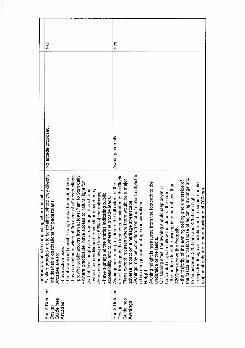
Awnings across street frontages This matter was raised with the applicant

JRPP (Northern Region) Business Paper – 9 December 2009 – Item No. 1 Page 26
• The design is not consistent with DCP 20 controls in that it does not provide for an awning as required along each of the nominated street frontage.
following an initial planning assessment of the application. The proposal has been amended to provide continuous awnings across the frontages to Gordon and Hayward Streets.
The articulation of facades • The design does not include articulation
within the façade zones at both ground level and upper level within DCP 20 controls with provision of a continuous wall.
The applicant has provided a response that the proposed facades to Gordon and Hayward Streets both contain elements that address the issue of articulation. The proposed façade facing the reserve along Kooloonbung Creek is not articulated. This façade is proposed to include elements that will given it interest consistent with a maritime theme. Articulation of this façade would create functional issues with the proposed building.
The view of proposed building from Church Hill as identified in DCP 20 • The view line B from Church Hills will be
adversely impacted by the proposed height of the building and the inclusion of canopy structures over the roof-top area parking.
The applicant has provided a response that the application includes a photomontage which addresses View B identified in DCP 20. The applicant considers that the proposal is consistent with the requirements of View B, as the vegetated horizon will remain part of the view on completion of the proposed development.
Connectivity between Gordon and Hayward Streets, including a laneway • The design does not provide for or enable
the inclusion in the future of a laneway from Hayward Street frontage to the Gordon Street frontage through the site for access. This is a significant loss of pedestrian amenity and connectivity given that the existing at-grade parking enables pedestrians to traverse unrestricted through the Council site between Hayward and Gordon Streets.
• DCP 20 block controls require provision of a laneway which would serve as a through site link from Hayward Street to Gordon Street.
The applicant has provided a response that the proposal includes a pedestrian link between Gordon and Hayward Streets including a ramp facilitating disabled access together with a lift and travelators. The proposal also includes significant improvements for pedestrians using the reserve along Kooloonbung Creek. These improvements include a ramp facilitating disabled access from Gordon Street to the reserve proper, lighting and seating. Connectivity will also be possible by using Horton Street. The applicant has provided a response that the only reference to a laneway in DCP 20 is the option for one to provide access loading areas, located on the eastern side of the Finnians Tavern property. There is no such need for a laneway to service the current proposals for the affected properties. There is also very little likelihood of the necessary cooperation between the affected property owners to provide a laneway in this location.
Activation of Gordon and Hayward Street frontages as well as the frontage to the reserve along Kooloonbung Creek • The design does not provide for sufficient
The applicant has provided a response that the proposal will activate the Gordon and Hayward Streets frontages. Other than the minor extent of activation that will be provided by the

JRPP (Northern Region) Business Paper – 9 December 2009 – Item No. 1 Page 27
shop frontages directly onto Hayward Street, Gordon Street or the foreshore area alignments to enable the possibility of street activating uses to be located at pedestrian footpath levels. As such the design principles of DCP 20 will not be achieved.
• The development will result in an inferior urban design outcome given the location of the loading dock adjacent to the foreshore reserve at the Hayward Street frontage, given the number of truck deliveries and requirements associated OH&S, this will restrict pedestrian access along Hayward Street to the foreshore reserve area and adversely affect public safety.
proposed bus terminal the frontages to the reserve of Kooloonbung Creek will not be activated. Given the nature and structure of the proposal activation of this frontage is not possible. The proposal does include measures to mitigate the blandness of this elevation, along with measures to improve the amenity of the reserve itself.
The height of the proposed development relative to the height of existing adjoining developments • The design of the development is
significantly larger in height when compared to existing development within this block and southern portion of the Port Macquarie town centre and given this larger scale is out of character with existing development.
• The design of the development does not make provision for any physical connections with land within the remainder of the block and as such will not result in an outcome as envisaged in the future character of this portion of the Port Macquarie Town Centre as outlined within DCP 20.
• The proposed development will adversely impact on adjoining properties and will result in orphaned allotments due to the lack of inclusion of all land within the block.
The applicant has provided a response that potential overshadowing of adjoining properties is the only issue that is relevant to comparison heights. The plans forming part of the application address overshadowing. Separately, DCP 20 indicates that the height of any development of the land should be a maximum of 4 storeys for the bulk of the site with a section up to 5 storeys and another section 3 storeys. The top of the columns supporting the proposed sails to provide shade for the rooftop car park are shown to be 13m above existing ground level. This proposed height is not uniform and will generally be less than 13m. The main structure of the building is 2 to 4m below the top of the columns. The proposal complies with DCP 20 with regard to height.
Lack of public benefit • The applicant has failed to demonstrate an
adequate assessment of the Council’s requirements and the overall effect of the departures will result in a development which is not in the public interest.
• On balance the inappropriate locations and lack of direct public access to the replacement facilities when compared to that currently enjoyed today, it is clear that the public benefit derived today from the replacement facilities will be diminished.
• The development will not bring about a like
The applicant has provided a response that the proposal includes retention of 14 public parking spaces and a bus terminal including public conveniences. Refer also to comments provided later in this report under section addressing public interest.

JRPP (Northern Region) Business Paper – 9 December 2009 – Item No. 1 Page 28
for like public benefit for the people of Port Macquarie, despite the inclusion of replacement car parking and replacement bus interchange. These adverse social impacts in themselves are unacceptable.
Independent assessment • The DA will need to be assessed by an
independent planner as part of its reporting process to the Joint Regional Planning Panel to ensure Council does not fetter its own interests.
Council executive management have resolved to have DA assessed internally with Council given the DA will be required to be reported to the independent JRPP for determination.
Relocation of bus stop in Gordon Street and potential interference with access to the car park for the proposed Dan Murphy Development • The relocation of the existing bus stop to a
position further east seems at odds with the concept of providing a bus interchange facility at the site.
• The position of the relocated bus stop is likely to conflict with future access to lot 8 which has limited accessible frontage to Gordon Street dues to its corner position and is currently vacant.
• The submitted TTM traffic report does not address the traffic implications of relocating the bus interchange facility and its relationship to the proposed access to the public car park from Gordon Street. Furthermore, there is the potential for traffic conflict between these two elements and the existing driveway to Finnians Tavern.
• Council has insufficient information to make an informed decision in regards to traffic impacts associated with relocating the bus interchange facility to Gordon Street.
The applicant has provided a response that they have reviewed the matter and agree that there is potential for conflict if the location of the repositioned bus stop is taken literally. The submitted plans demonstrate a general location for a repositioned bus stop that would not interfere with future access to the proposed Dan Murphy carpark. The relocation of the bus stop requires consideration by Council and the Local Traffic Advisory Committee. The applicant has provided further commentsthat another option would be to combine the local bus stop with the operation of the bus terminal and therefore not relocate it, to any significant degree. The detailed resolution of this issue is beyond the scope of the application.
Potential for conflict between the proposed bus terminal and access to rooftop car park • The proposed ramp off Gordon Street to
the rooftop car parking area will potentially exacerbate traffic issues in Gordon Street given its location close to the proposed bus interchange facility, bus stop and entry to Finnians Tavern car park.
• The TTM traffic report states that the rooftop car parking will not result in any additional traffic generation. However it does not take into account the relocation of this driveway to Gordon Street and vehicular movements in and out of the
This matter of concern was raised as part of the initial assessment of the application. The applicant has provide a response that proposal has been amended to include a layby for buses using the terminal, thereby allowing vehicles entering the access to utilise a separate deceleration lane and also ensuring clear visibility for vehicles exiting the carpark. Refer also to comments made later in report under access, traffic and transport.

JRPP (Northern Region) Business Paper – 9 December 2009 – Item No. 1 Page 29
carpark. The requirements for an economic impact assessment • There is no economic impact statement
provided with the DA. The application relies on the Leyshon Consulting report and supplementary advice from Hill PDA regarding the future retail demands with the LGA.
• The statement of environmental effects fails to acknowledge that the proposal includes over 4,400m2 of additional retail floor space. The existing Coles supermarket premises when vacated will be available to another retail use.
• Since 2006 three major retail developments have been approved within the LGA which increases the approved retail floor space by over 10,200m2 well in excess of the 3,000m2 shortfall identified in the 2006 Leyshon report. The economic impact of this has not been addressed.
The applicant has provide a response that none of the 3 supermarkets referred to are in Port Macquarie. The proposal is to relocate an existing supermarket. It is likely that any reoccupation of the existing supermarket premises will require a further DA. The 2007 PDA report stated that the Greater CBD of Port Macquarie will require an additional 2,600m2 of retail space on an annual basis.
Site contamination and provisions of SEPP 55
• The Cavvanba site investigation report is accompanied by limited soil and groundwater testing.
• The Cavvanba report concludes that the groundwater in the north east section of the site is contaminated with volatile organic compounds associated with up gradient off site sources being the adjacent service station and dry cleaner. The report recommends that further investigation to determine the extent of groundwater contamination followed by further evaluation of options including environmental and human health risk assessment.
• Without a remediation action plan, Council is not in a position to comply with its obligations under SEPP55.
This matter can be appropriate addressed via an appropriate condition of consent. Refer to comments provided earlier in this report under the section addressing SEPP 55.
Hours of deliveries With regard to nearby residential apartments to the west a request has been received to consider curfew times that the semi trailers would be unloading goods at night as could create a lot of noise.
It is recommended that the hours of deliveries be conditioned to be confined to be between 7am to 10pm, 7 days a week.
Restriction to rooftop parking Question whether time restrictions are going
The application does not include any details identifying restricted hours of access. Access

JRPP (Northern Region) Business Paper – 9 December 2009 – Item No. 1 Page 30
to be placed on the rooftop parking. from the rooftop to the Coles supermarket however will be restricted in line with trading hours.
Weather protection with bus terminal • Would appear that there is limited
protection from the elements for passengers both boarding and alighting from buses. As a minimum there should be an awning or similar roof covering extending from the Terminal Building out and over where it is planned for buses to load and unload similar to that at the current terminal.
The submitted plans indicate an awning proposed to cover the public footpath to the front of the terminal. In accordance with DCP 20 the awning needs to be setback from the kerb.
(e) The Public Interest:
Issues of concern raised in submissions received following public exhibition of the proposal have been addressed in this report.
With regard to the overarching public interest consideration, it is imperative that consideration be given as to whether the public advantages of the proposal outweigh to some extent possible disadvantages of the proposal. For reasons stated, it is apparent that there is significant public benefit to be derived from the provision of a new additional publicly accessible major retail attraction at the southern end of the CBD area. This will maintain Port Macquarie's role as the primary business and retail centre on the Mid North Coast. The proposal provides for significant impetus for the higher utilization of the site to support economic activity within the town centre while maintaining the provision of required public car parking and public bus passenger facilities. Despite the perceptible difficult constraints and issues with likely impacts on the public domain, the development is incapable of providing for continuous activation of all street block interfaces. On balance, it is considered that the benefits outweigh the perceptible disbenefits and as such the proposed development will have an overall net public benefit.
Interim Port Macquarie-Hastings Flood Policy April 2007
The assessment of the proposal with regard to the potential for flooding impacts has been addressed earlier in this report under the section addressing Hastings LEP 2001 taking into consideration of the requirements of this Interim Policy.
Retail Policy Plan
The objectives of the Retail Policy are to
1. To maintain and enhance the present hierarchy of retail centres throughout the Hastings Local Government Area.

JRPP (Northern Region) Business Paper – 9 December 2009 – Item No. 1 Page 31
2. To encourage new retail development (Note 1) to occur within the existing identified CBDs of the Hastings LGA (Note 2) to meet the needs of a resident population of 97,800 people and a sub-regional population of 150,000.
3. New retail centres (Note 1) to be restricted to neighbourhood centres servicing new urban areas, apart from those within the CBDs referred to in Objective 2 above.
4. To provide for additional major retail development in the long term (Note 3) 5. To retain higher order retail services within the CBDs.
The proposal is consistent with the objectives of the Policy in that it will be located within the Port Macquarie CBD and will strengthen the retail offered by this CBD.
Draft DCP 17 – Subdivision Code
The proposed subdivision component of the proposal satisfies the objectives and proposed guidelines of this draft DCP, as exhibited.
Climate change
An appropriate condition is recommended to require that minimum flood protection which makes allowance for any future sea level rise predictions in accordance with the requirements of the NSW Sea Level Rise Policy Statement (October 2009) and requiring submission of an appropriate flood management plan. 5. DEVELOPMENT CONTRIBUTIONS APPLICABLE • Development contributions will be required towards augmentation of town water
supply and sewerage system head works under Section 64 of the Local Government Act 1993.
• A condition is recommended to require payment of Section 94A of the Environmental Planning and Assessment Act 1979 towards public road improvements within the locality.
6. CONCLUSION The application has been assessed in accordance with Section 79C of the Environmental Planning and Assessment Act 1979. Issues raised during assessment and public exhibition of the application have been considered in the assessment of the application. Where relevant, conditions have been recommended to manage the impacts attributed to these issues. The site is suitable for the proposed development, is not contrary to the public's interest and will not have a significant adverse social, environmental or economic impact. It is therefore recommended that the application be approved subject to the recommended conditions of consent provided in the attachment section of this report. 7. ATTACHMENTS: